IAN WHITE ASSOCIATES. Crawley Station Gateway Public Realm
|
|
|
- Shanon French
- 5 years ago
- Views:
Transcription

1 IAN WHITE ASSOCIATES Crawley Station Gateway Public Realm
2 contents 1. objectives & client brief 2. site appraisal 3. best practice guidance 4. design concept
3 1. objectives & client brief Crawley Train Station is a major gateway to the town with around 2 million people passing through it each year*.it is within the top 10% busiest stations within the UK. Crawley Borough Council have identified the station along with surrounding environs as an area for redevelopment and improvement to the public realm. The existing main pedestrian link between the station and town centre is a difficult, convoluted route across a busy dual carriageway gyrator road. The station forecourt is somewhat neglected, with poor accessibility, and most space given over to car parking.bus interchange facilities are adjacent, but could be improved to provide a more comfortable user experience. There is a desire for seamless connectivity between the train and bus stations and town centre, that encompasses all users, and to create a high quality, distinctive public realm that is safe and secure. * Office for Rail Regulation statistics

4 2. site appraisal type of destination By applying TfL definitions, Crawley can best be described as a Metropolitan station: close to the town centre; acts as an interchange hub between local modes of transport; and has to the balance the needs of conflicting user groups.
5
 Missing link in cycling infrastructure limits access to bus / railway station Dual carriageway barrier to pedestrian")
6 Town Centre Linkages: Existing Key Core Retail Area Key Pedestrian Routes Cycle Routes Bus Routes Key Vehicular Routes Vehicles Allowed, but Pedestrian / Cycle Friendly (20mph speed limit) Missing link in cycling infrastructure limits access to bus / railway station Dual carriageway barrier to pedestrian connectivity
 ramp with upstand kerbs offer poor pedestrian accessibility -")
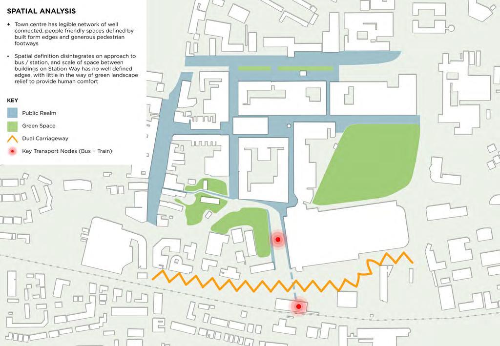
7 Movement and Spatial Analysis to and from Station: Existing Key Pedestrian Priority Area Vehicular Priority Area Safe Pedestrian Movement through Vehicular Area - Imbalance of vehicular space relative to pedestrian space - Very limited public realm to station forecourt - Stepped access and non compliant (1 in 11 grade) ramp with upstand kerbs offer poor pedestrian accessibility - Circuitous and staggered route to town centre


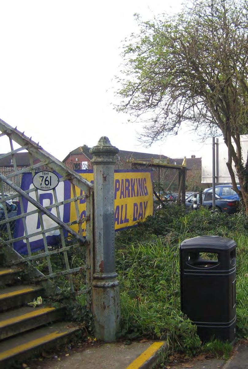
8 site appraisal Train Station - degraded public realm

9 site appraisal Poor pedestrian accessibility

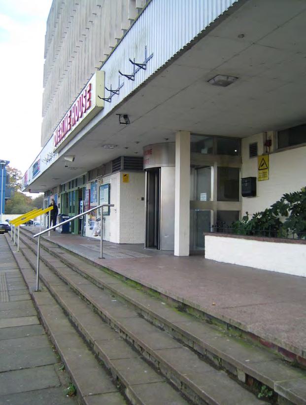
10 site appraisal Bus Station - Poor pedestrian accessibility to shopping centre with pinched waiting / movement space

11 site appraisal Station Way - Vehicular dominated space with little landscape relief

12 site appraisal Rebalance the street


13 3. best practice guidance Our approach is underpinned by current best practice Design Guidance: Places & Spaces Urban Realm on the Crossrail Route 2015 Town Centre Toolkit Scottish Government 2015 Royal Docks Local Transport Design Guidance 2015 Manual for Streets Dept Transport UK Govt 2007/2011 Designing Streets Scottish Government 2010

14 best practice guidance Context Particularly relevant is the: Station and Public Realm Design Guidance Transport for London TfL 2015 TfL Station Public realm guidance states that the space outside a station should support both the station itself and the local area. This goal can be broken down into 4 objectives for the public realm, which are entirely relevant and applicable to Crawley...


15 best practice guidance Objectives 1. TRANSPORT: Optimise local operation of the transport system 2. PLACE MAKING: Enhances the sense of place 3. COMMUNITY: Develop socially engaging places that unlock community benefit 4. COMMERCIAL: Support the local economy and generate commercial revenue, encouraging confidence in the wider regeneration of Crawley town centre

16 best practice guidance Movement A critical element for successful design of the Urban Realm is achieving a balance between Movement and Place The needs of all users must be addressed and well integrated. However, all users of Stations will be pedestrians within the public realm at some point in their journey, and the total number of pedestrians in the space will almost always outweigh the number of other types of users. The hierarchy of user, reflecting best practice, must in general prioritise Pedestrian Movement FIRST, then Cyclists,Public Transport and finally the Car. Encouraging more pedestrian movement helps to activate the street, reduce congestion on the public transport and road network, and provides benefits to an individual s health and wellbeing.

17 best practice guidance Prioritise


18 best practice guidance Place Place making is about creating spaces that are attractive and functional. It makes more than just a through route by supporting the needs of users, enhancing their experience and giving them a reason to spend time there.


19 4. design concept Rebalance and optimise the quality of the urban environment by prioritising pedestrians first in the movement hierarchy, and creating a vibrant and attractive place, that is safe for all.

20 wider public realm Friary Way - tree line extended with more generous footways Station Way - segregated bike lanes and greening of central reservation possible by reducing lane no s from 4 to 3 and narrowing the width to 3.2m per lane people friendly junction Station square - high quality public realm

21 Station Square Proposed Movement / Spatial Arrangement to Station Square Key Pedestrian Priority Area Vehicular Priority Area Safe Vehicular Movement through Pedestrian Area insert proposed movement / place Station diagram

22 Station Square raised table with change in surface material generous, direct and at-grade crossings high quality paving taxi drop off drop off zone drop off apartments retail / cafe cycle parking apartments station entrance apartments multi storey car park
23 Station Square - dedicated left turn bus lane option buses only raised table with change in surface material buses only dedicated left turn bus lane buses only buses only generous, direct and at-grade crossings high quality paving taxi drop off drop off zone drop off apartments retail / cafe cycle parking apartments station entrance apartments multi storey car park


24 design concept Public Realm upgrade of the public realm to the Station forecourt that provides a positive first impression upon arrival is safe and secure which supports a number of social activities

25 design concept Activity zones & Movement arrival / ticket zone local info zone social zone waiting zone retail / social zone waiting zone


26 design concept People Friendly Junctions where cars pass through people spaces in a safe and controlled manner, rather than the other way around at grade / step-free access to crossings Reduce vehicle design speed from 30mph to 20mph on Station Way tighten geometry on turning radii and narrow lane width


27 design concept Cycling provide segregated cycle lanes on Station Way completing a key link to the town s cycle infrastructure add cycle parking at the Station bike rail to any steps internal or external Single Footpath Cycleway Dual carriageway carriageway Cycleway Footpath

28 pelican crossing design concept Enhance Bus Station improve environment for users focusing on comfort, generous pedestrian movement space, and safe crossings bus stops positioned to road side and omitting sawtooth alignment frees up pedestrian circulation pelican crossing direct to mall entrance space in both directions for set down and passing of buses bus holding lane omitted to enable space for central reservation landscape and widening of footways


29 design concept Wayfinding, Signage and Information developing a strategy that provides clear legibility, local info and ease of getting around for users


30 design concept Station Way & Friary Way enhance the attractiveness and comfort of the public realm street trees and hedging good quality street lighting colourful decorative screens where required to segregate vehicles from people


31 design concept Street Furniture & Paving hierarchy of good quality paving materials that reflect Station Square as a key activity node and important place multi-purpose surfacing must be durable and robust street furniture should be uniform, contemporary and support a wide range of use and activities


32 design concept Summary Applying principles of pedestrian priority within hierarchy of Public Realm, and achieving a balance between movement and placemaking. - Co-ordination and enhancement of wider Public Realm - Station Square improvements - Activity zones and movement - People friendly junctions that provide safe passage for vehicles through a people space - Accomodate and integrate cyclists better - Enhance bus station - Legible wayfinding and signage - Enhance Station Way - Robust, good quality materials and street furniture
33 Station Square - dedicated left turn bus lane option Developed following stakeholder consultation + feedback
34 Bus Station - Haslett Avenue West + Friary Way Developed following stakeholder consultation + feedback bus waiting (x4) - Maintain current no. of stances (10 no.) - Bus waiting for 4 buses to Haslett Avenue West (taxi rank re-location required) - Central landscape strip trees and hedging - Increase in no. of pedestrian crossing points
35 Crawley Station Gateway - wider public realm Developed following stakeholder consultation + feedback - Bus station extended to Haslett Avenue bus waiting (x4) West - Dedicated left turn lane for buses exiting Friary Way - 3 bus stacking right turn lane from Station Way into Friary Way - Landscape extended east from County Mall roundabout to west end of Station Way - Station Way to 20mph zone
DMURS - Practical Implications
 Comhairle Contae Fhine Gall DMURS - Practical Implications Sean McGrath. 13 November 2013 Planning and Strategic Infrastructure Department DMURS Practical Implications What DMURS means for: Street Layouts
E4 Cycle Route Exeter University to Redhayes Bridge. - Recommendations from Exeter Cycling Campaign
 E4 Cycle Route Exeter University to Redhayes Bridge - Recommendations from Exeter Cycling Campaign 1.0 Introduction Exeter Cycling Campaign has prepared this report to provide recommendations for Devon
Frascati Road and Temple Hill Route Improvements. Outline Design Report to Accompany Public consultation
 Frascati Road and Temple Hill Route Improvements Outline Design Report to Accompany Public consultation September 2013 Background: Dún Laoghaire-Rathdown is committed to providing high quality pedestrian
ENFIELD TOWN THE REVISED DESIGN
 TOWN THE REVISED DESIGN We re turning Enfield into a borough that encourages walking and cycling, a place that s easy for all of us to get around however we choose to travel. A greener place, with safer
BYRES ROAD: PUBLIC REALM Public Consultation
 Public Consultation Introduction As a vibrant commercial, shopping and residential location within the heart of the West End Byres Road is an important destination. Its proximity to the University of Glasgow
Living Streets response to the Draft London Plan
 Living Streets response to the Draft London Plan Contents Living Streets response to the Draft London Plan... 1 About Living Streets... 2 Summary... 2 Consultation response... 3 Chapter 1: Planning London
DESIGN CODE. Enterprise West Harlow London Road North Design Code 21
 DESIGN CODE Enterprise West Essex @ Harlow London Road North Design Code 21 4 MAXIMUM BUILDING HEIGHTS 4.1 Table 4A sets out maximum building height standards for each character area within the LDO boundary.
Part B Design Guidance / Principles _
 Part B Design Guidance / Principles www. landlab.co.nz Queenstown Town Centre Public Realm Design Guidelines Version 7 14 June 2018 Page 006 B1 Design Guidance & Best Practice The Queenstown Town Centre
Introduction. Prince Street Cycling Ambition Fund Public Realm Project
 Introduction The (CAF) project will create a high quality, 8-80 s cycle route up the west side of Prince Street from Cumberland Road, over Prince Street bridge to the Centre. This is part of the City Centre
LEA BRIDGE ROAD - A STREET FOR EVERYONE Public consultation document
 LEA BRIDGE ROAD - A STREET FOR EVERYONE Public consultation document TELL US Bakers Arms to Leyton Green Road (Section D, E, F) Leyton Green Road to Whipps Cross Roundabout (Section G) YOUR VIEWS www.enjoywalthamforest.co.uk
TRANSPORT AND MOVEMENT
 TRANSPORT AND MOVEMENT Movement Strategy Public Transport Cycling and Walking Road Network Parking Standards Transport Impact Assessments Traffic Management Policies DRAFT POOLBEG PLANNING SCHEME Movement
4.0 transport requirements
 4.0 transport requirements 4.1 Transport Demand forecasting Arrival & departure models of people using oxford station For the purposes of this masterplanning work a time horizon of 2043 has been assumed
The Cabinet Member for Highways & Streetscene. Aurang Zeb - Head of Highways & Transport
 LONDON BOROUGH OF RICHMOND UPON THAMES Cabinet Member Decision DATE: January 2012 REPORT OF: LEAD OFFICER: SUBJECT: WARDS: The Cabinet Member for Highways & Streetscene Aurang Zeb - Head of Highways &
Cabinet Member for Highways & Streetscene. Highway Infrastructure Manager
 LONDON BOROUGH OF RICHMOND UPON THAMES DATE: AUGUST 2015 DECISION MAKER: LEAD OFFICER: SUBJECT: WARDS: Cabinet Member for Highways & Streetscene Highway Infrastructure Manager PROPOSED CYCLING IMPROVEMENTS
HISTON ROAD Have your say on better public transport, cycling and walking journeys
 HISTON ROAD Have your say on better public transport, cycling and walking journeys Have your say: Please complete the survey inside this leaflet or online at www.greatercambridge.org.uk/histonconsultation
21.07 TRANSPORT CONNECTIVITY AND INFRASTRUCTURE
 21.07 TRANSPORT CONNECTIVITY AND INFRASTRUCTURE 21.07-1 Connectivity and Choice Transport connectivity and mode choice are critical to achieving productive, sustainable and socially just cities. Travel
High frequency bus services operating to Little Island; Creation of a new Park and Ride site and train station at North Esk;
 Cork County Council 7 th December 2018 Dear Adrian O Neill (aoneill@jbbarry.ie) The Transport and Mobility Forum, Cork (TMF) is a representative group of organisations who have a common interest in sustainable
How do we design for pedestrians? Case study: transforming the Walworth Road
 How do we design for pedestrians? Case study: transforming the Walworth Road David Moores, Director of Public Realm Institution of Highways and Transportation, November 2009 Presentation overview Design
Have your say on the transformation of Oxford Street West
 Have your say on the transformation of Oxford Street West About Living Streets We are Living Streets, the UK charity for everyday walking. We want to create a walking nation, free from congested roads
Bentleigh GLEN EIRA COUNCIL TRANSFORMATIONAL CONCEPTS 15
 2 Bentleigh GLEN EIRA COUNCIL TRANSFORMATIONAL CONCEPTS 15 Bentleigh Bentleigh urban design context The Bentleigh activity centre is a busy strip shopping centre that runs along Centre Road and is dissected
REF. PE01595: MORATORIUM ON SHARED SPACE SCHEMES
 PE1595/RRR Sustrans submission of 17 March 2017 Following the Public Petitions Committee meeting on 9 th February 2017 you wrote to Sustrans Scotland requesting a clarification on our position on the use
Douglas Land Use and Transportation Strategy (DLUTS) Summary. August 2013
 Summary. August 2013") Douglas Land Use and Transportation Strategy (DLUTS) Summary August 2013 Background Douglas is a large and popular residential suburb of approximately 30,000 persons on the periphery of Cork City along
Douglas Land Use and Transportation Strategy (DLUTS) Summary August 2013 Background Douglas is a large and popular residential suburb of approximately 30,000 persons on the periphery of Cork City along
Joint Response to the Department for Transport Consultation on the Station Champions Report on Better Rail Stations. February 2010
 Joint Response to the Department for Transport Consultation on the Station Champions Report on Better Rail Stations Joint Response to the Better Rail Stations Consultation This response has been prepared
Chelmsford City Growth Package
 Chelmsford City Growth Package Public Consultation Document Volume 2 West Chelmsford July - August 2017 Chelmsford City Growth Package Public Consultation Document - Volume 2 - West Chelmsford Contents
Transportation Master Plan Advisory Task Force
 Transportation Master Plan Advisory Task Force Network Alternatives & Phasing Strategy February 2016 BACKGROUND Table of Contents BACKGROUND Purpose & Introduction 2 Linking the TMP to Key Council Approved
IMPLEMENTATION. PEDESTRIAN USERS (Continued /) A: Class 2 Pedestrian / Cycle Ways. Pedestrian and Cycle Ways:
 A: Class 2 Pedestrian / Cycle Ways. Pedestrian and Cycle Ways:") A: Class 2 Pedestrian / Cycle Ways PLAN VIEW Pedestrian and Cycle Ways: Layout and Geometry (Refer to A): Walkways and cycle to be provided adjacent to all Class 2 Roads (these facilities should always
A: Class 2 Pedestrian / Cycle Ways PLAN VIEW Pedestrian and Cycle Ways: Layout and Geometry (Refer to A): Walkways and cycle to be provided adjacent to all Class 2 Roads (these facilities should always
MARKHOUSE ROAD IMPROVEMENTS
 MARKHOUSE ROAD IMPROVEMENTS www.enjoywalthamforest.co.uk Waltham Forest is changing and we want you to be part of it. Thanks to a funding pot of 27million from Transport for London, we re delivering the
IMPLEMENTATION. PEDESTRIAN USERS (Continued /) Building Frontages: A: Stair Applications. Geometry (Accessed from the Sidewalk) Refer to A:
 Building Frontages: A: Stair Applications. Geometry (Accessed from the Sidewalk) Refer to A:") A: Stair Applications Building Frontages: Geometry (Accessed from the Sidewalk) Refer to A: Ramps should be provided for disabled users at 1:12 (8.3%) gradient. Ramp rises should be stepped at 400mm intervals.
A: Stair Applications Building Frontages: Geometry (Accessed from the Sidewalk) Refer to A: Ramps should be provided for disabled users at 1:12 (8.3%) gradient. Ramp rises should be stepped at 400mm intervals.
Green Streets and Urban Greenways
 127 11 Green Streets and Urban Greenways 11. Green Streets and Urban Greenways 128 11 Green Streets and Urban Greenways Once the traffic-free section of a route has come to an end, then comes the remaining
Complete Streets. Designing Streets for Everyone. Sarnia
 Complete Streets Designing Streets for Everyone Sarnia Complete Streets ~ Sarnia ~ 2018 Introduction Our City is made up of a network of streets that we use to go for a walk, cycle to work, drive to the
Urban Street Design with DMURS. Sean McGrath Senior Executive Engineer Fingal County Council
 Urban Street Design with DMURS Sean McGrath Senior Executive Engineer Fingal County Council Urban versus Rural Design Rural Road Design Prefer higher speed Release constraints Work within fence line Urban
Strategy for Walking & Cycling Action Plan
 Strategy for Walking & Cycling Action Plan To achieve higher levels of walking and cycling activity, the destinations which people access have to be available within suitable distances and designed to
Public Consultation on Braintree Integrated Transport Package (ITP) HAVE YOUR. Consultation open from 24 September to 5 November 2018 SAY
 HAVE YOUR. Consultation open from 24 September to 5 November 2018 SAY") Public Consultation on Braintree Integrated Transport Package (ITP) HAVE YOUR SAY Consultation open from 24 September to 5 November 2018 Contents Introduction 3 Background 4 Springwood Drive Roundabout
Public Consultation on Braintree Integrated Transport Package (ITP) HAVE YOUR SAY Consultation open from 24 September to 5 November 2018 Contents Introduction 3 Background 4 Springwood Drive Roundabout
Rhebogue Neighbourhood Greenway. Road Safety Audit Stage 2
 Rhebogue Neighbourhood Greenway Road Safety Audit Stage 2 Report Number: 12/007/00/00057 July 2014 Mid West National Road Design Office Lissanalta House, Dooradoyle County Limerick Tel: 061 496 800 Fax:
Nottingham Cycle City Frequently Asked Questions
 Nottingham Cycle City Frequently Asked Questions About the scheme How much money is to be spent on cycling? And where is the money from? We have 6.1 million in Growth Fund which we will be investing directly
Dún Laoghaire Rathdown County Council. Luas to Dart via UCD Cycle and Pedestrian Route
 Dún Laoghaire Rathdown County Council Luas to Dart via UCD Cycle and Pedestrian Route October 2012 Luas to Dart via UCD Cycle and Pedestrian Route DOCUMENT CONTROL SHEET Client: Project Title: Document
MAGNA PARK Lutterworth. DHL SUPPLY CHAIN: Design and Access Statement. June
 DHL SUPPLY CHAIN: Design and Access Statement June 2015 CONTENTS SECTION - The Access Proposals 9.1. Site Access 140 9.2. Mere Lane 140 9.3. A5 140 9.4. Footpaths, cycle ways and bridleways 142 SECTION
Design Workshops Summary of all Feedback January 2017
 Histon Road Corridor Design Workshops Summary of all Feedback January 2017 CITY DEAL AND GROWTH Commitment to Growth: Government, County, City and District Emerging Local Plans: 33,000 new homes 45,000
City of Perth Cycle Plan 2029
 Bicycling Western Australia s response City of Perth Cycle Plan 2029 2012-2021 More People Cycling More Often ABOUT BICYCLING WESTERN AUSTRALIA Bicycling Western Australia is a community based, not-for-profit
WELCOME. Purpose of the Open House. Update you on the project. Present a draft recommended plan. Receive your input
 WELCOME Purpose of the Open House The Town of Smiths Falls has initiated the Beckwith Street Redevelopment Plan that includes the preparation of a streetscape functional design for the renewal of Beckwith
Bulwell Cycling Consultation
 Bulwell Cycling Consultation Image 1 Bulwell Bogs (Sutton, 2015) As part of a final year research project, I am seeking feedback on proposals for cycling improvements in Bulwell. This consultation is not
interchange audit ABERDEEN Introduction Purpose of the Interchange Audit Interchange Audit Linking cycling with public transport
 interchange audit ABERDEEN Bus Station RAILWAY Station FERRY PORT Interchange Audit Susan Warren Jolin Warren 20 March 2014 Linking cycling with public transport Image copyright Boon Low Introduction Purpose
Tonight is for you. Learn everything you can. Share all your ideas.
 Strathcona Neighbourhood Renewal Draft Concept Design Tonight is for you. Learn everything you can. Share all your ideas. What is Neighbourhood Renewal? Creating a design with you for your neighbourhood.
London Cycle Network Annual Report 2000
 London Cycle Network Annual Report 2000 A cycle network for London by 2005 A cycle network for London by 2005 The London Cycle Network will: provide local links between residential neighbourhoods, railway
FOCUS AREA 1 - Alberta Avenue Pocket Park 3 (121 Ave and 92 St)
") FOCUS AREA 1 - Alberta Avenue Pocket Park 3 (121 Ave and 92 St) New benches Plant evergreen trees Widen existing sidewalk from 1.5m to 1.8m Marked crosswalk 1.8m wide sidewalk Add pedestrian oriented lights
FOCUS AREA 1 - Alberta Avenue Pocket Park 3 (121 Ave and 92 St) New benches Plant evergreen trees Widen existing sidewalk from 1.5m to 1.8m Marked crosswalk 1.8m wide sidewalk Add pedestrian oriented lights
Lea Bridge Road A street for everyone Tell us
 Lea Bridge Road A street for everyone Tell us Public consultation document Section H your views 1 Lea Bridge Road: a street for everyone Introduction Mni-Holland is an exciting programme to improve walking
HAMILTON BIKING PLAN OUR VISION: A BIKE FRIENDLY CITY
 HAMILTON BIKING PLAN 2015-2045 OUR VISION: A BIKE FRIENDLY CITY INTRODUCTION Biking as a travel option is experiencing a resurgence internationally and in New Zealand, growing as a familyfriendly and healthy
Woolwich Ferry A205 PURPOSE OF VISITING THE TOWN CENTRE. Usually for shopping (particularly groceries) and for transport PARTS OF WOOLWICH VISITED
 and for transport PARTS OF WOOLWICH VISITED") INTRODUCTION ABOUT THE STRATEGY WHAT HAS HAPPENED SO FAR? Woolwich is changing. Recent new developments and the arrival of Crossrail are creating a huge opportunity for tranformation in Woolwich. This
INTRODUCTION ABOUT THE STRATEGY WHAT HAS HAPPENED SO FAR? Woolwich is changing. Recent new developments and the arrival of Crossrail are creating a huge opportunity for tranformation in Woolwich. This
Your views are important. Please fill in a form before you leave. Or alternatively
 Drum Property Group is delighted to welcome you to this exhibition which sets out our initial proposals for a mixed-use development at Stead s Place, Edinburgh. We are keen to hear the views of local people
TS 109 DURHAM ROAD QTC PHASE 4 PROJECT PROPOSAL. Page 1
 TS 109 DURHAM ROAD QTC PHASE 4 PROJECT PROPOSAL Page 1 Table of Contents 1.0 Introduction... 3 2.0 Project Overview... 3 3.0 Project Proposals... 4 3.1 Enfield Road / Durham Road Junction... 3 5 3.2 Summerfield
Space for Cycling. A guide for decision makers
 Space for Cycling A guide for decision makers Why create Space for Cycling? Imagine your area with considerably less traffic. Imagine safe streets and neighbourhoods, clean air, young and old alike able
Issues at T junctions:
 TheSlade_PublicConsulationPlans_March2017.pdf These comments relate to junction designs in this phase of the project on The Slade. Comments begin with the northernmost junction: Girdlestone Rd and continue
GLEN EIRA CITY COUNCIL. MURRUMBEENA Transforming our neighbourhood together our concepts based on your ideas
 GLEN EIRA CITY COUNCIL MURRUMBEENA Transforming our neighbourhood together our concepts based on your ideas 1 WHAT HAVE WE HEARD? WHAT NOW? Stage one Tell us what you love about your shopping strip November
PROMOTING 20MPH. Photo
 PROMOTING 20MPH Photo Inverness City Centre We are Living Streets Scotland, part of the UK charity for everyday walking. We want to create a walking nation where people of all generations enjoy the benefits
Transport Workshop Dearbhla Lawson Head of Transport & Infrastructure Policy & Funding University of the Third Age.
 Transport Workshop Dearbhla Lawson Head of Transport & Infrastructure Policy & Funding University of the Third Age 30 th March 2015 1 Presentation Overview Roles and responsibilities Snapshot of Key Challenges
PLACE CONCEPT! DESIGNS. Simplified crossroads junction to take traffic away from the heart of Picardy Place
 ith W alk Le Simplified crossroads junction to take traffic away from the heart of Picardy Place lace Quality public space & transport interchange hub surrounding new development. P York Wider pavements
Chelmsford City Growth Package
 Chelmsford City Growth Package Public Consultation Document Volume 5 South and East Chelmsford July - August 27 Chelmsford City Growth Package Contents Introduction 5 Army and Navy Roundabout Improvements:
Contents Location Map Welcome and Introduction Travel Plan Management Science Park Accessibility Walking Cycling Bus Rail Car Sharing Contact Details
 Contents Contents Location Map Welcome and Introduction Travel Plan Management Science Park Accessibility Walking Cycling Bus Rail Car Sharing Contact Details 1 2 3 5 7 9 11 13 15 17 19 Thames Valley Science
Marcus Jones, TRL. Presented by Name Here Job Title - Date
 Segregation Insert the title and of priority your at presentation junctions: a here discussion Marcus Jones, TRL Presented by Name Here Job Title - Date Background: TfL cycle facility trials Infrastructure
A future cycle route network for North Staffordshire mb/08/16 Need for a strategy. Existing cycle route network
 Need for a strategy 1. The government s aim is to double cycling levels nationally by 2025 [note 1]. This would bring significant health, environmental, economic and traffic benefits [note 2]. It is widely
Principles. 4biii. Good Urban Design
 Principles Good Urban Design The Sherford approach to the hierarchy of travel modes is fostered and encouraged by a combination of influences. These are as follows, described in further detail below: Town
Temple Circus Consultation. Consultation Capture Report
 Temple Circus Consultation Consultation Capture Report February 2017 Contents Introduction... 2 Background to the scheme... 2 Wider context... 2 Methodology... 4 Consultation materials... 4 Leaflet...
Guildford Borough (Draft)
") ITEM Annex Page 7 Guildford Borough (Draft) Forward Programme Part A This is a work in progress and its completion is subject to the adoption of the Local Plan and Infrastructure Delivery Schedule November
ITEM Annex Page 7 Guildford Borough (Draft) Forward Programme Part A This is a work in progress and its completion is subject to the adoption of the Local Plan and Infrastructure Delivery Schedule November
Wayfinding and Walking in London. Lilli Matson Transport for London May 2013
 Wayfinding and Walking in London Lilli Matson Transport for London May 2013 I want to make walking in London as attractive and enjoyable as possible by making walking count Mayor of London Boris Johnson
March Maidstone Integrated Transport Strategy Boxley Parish Council Briefing Note. Context. Author: Parish Clerk 2 March 2016
 Context. Author: Parish Clerk 2 The Draft Integrated Transport Policy (DITS) sets out a vision and objectives, and identifies a detailed programme of interventions to support the Maidstone Borough Local
NW Bicester Masterplan. Access and Travel Strategy Appendix 2 Walking and Cycling Linkages
 NW Bicester Masterplan Access and Travel Strategy Hyder Consulting (UK) Limited 2212959 HCL House Fortran Road St Mellons Business Park St Mellons Cardiff CF3 0EY United Kingdom Tel: +44 (0)29 2092 6700
Proposed. City of Grand Junction Complete Streets Policy. Exhibit 10
 Proposed City of Grand Junction Complete Streets Policy Exhibit 10 1 City of Grand Junction Complete Streets Policy Vision: The Complete Streets Vision is to develop a safe, efficient, and reliable travel
Easton Safer Streets - Final Project Report BRISTOL
 - Final Project Report BRISTOL A Sustrans Community Street Design Project in partnership with Bristol City Council February 07 About Sustrans Sustrans makes smarter travel choices possible, desirable and
Christchurch 3 years on: - growing resilience
 Christchurch 3 years on: - growing resilience Presentation to Road Controlling Authorities Forum 9 May 2014 Michael Blyleven Presentation Outline The Earthquakes The Damage The Recovery Plan An Accessible
10 SHERFORD Town Code
 Key Fixes (Ref: Masterplan Book, section 4a. Land Use Budget and Key Fixes ) The Town Plan designs and allocates buildings, streets and spaces as accurately as possible in the understandable absence of
Report from Embassy Visit to Copenhagen May David Arditti
 Report from Embassy Visit to Copenhagen May 2013 David Arditti Standard CPH cycle track, one-way 1.5 2m wide, 5cm above carriageway, 5cm below footway Basic one-way cycle track protected by car parking
Exhibit 1 PLANNING COMMISSION AGENDA ITEM
 Exhibit 1 PLANNING COMMISSION AGENDA ITEM Project Name: Grand Junction Circulation Plan Grand Junction Complete Streets Policy Applicant: City of Grand Junction Representative: David Thornton Address:
Highland Creek Village Transportation Master Plan
 Highland Creek Village Transportation Master Plan Information Booklet On-Street Parking Discussion November 9, 04 Highland Creek Village Transportation Master Plan www.toronto.ca/hcvtransportation Old
 COMPLETE STREETS CHECKLIST City of Philadelphia The City of Philadelphia's Complete Streets policies are designed ensure that city streets are safe, comfortable and convenient for people of all ages and
Tel: Karime Hassan Chief Executive Exeter City Council Civic Centre Paris Street Exeter EX1 1JN
 Page 1 of 6 Karime Hassan Chief Executive Exeter City Council Civic Centre Paris Street Exeter EX1 1JN Dear Mr Hassan 14th September 2015 Re: Development of Bus & Coach Station Site Following the submission
Perne Rd / Radegund Rd Roundabout Cambridge
 Perne Rd / Radegund Rd Roundabout Cambridge The conversion of an conventional urban roundabout to continental geometry A little bit of history The first traffic roundabout was built in Sollershott, Letchworth
Developing a Birmingham Transport Space Allocation policy. David Harris Transport Policy Manager Economy Directorate Birmingham City Council
 Developing a Birmingham Transport Space Allocation policy David Harris Transport Policy Manager Economy Directorate Birmingham City Council Birmingham s Sustainable Urban Mobility Plan Birmingham Connected
Welcome! Public Open House on UBC s Transportation Plan
 1 Welcome! Public Open House on UBC s Transportation Plan Public open house hours: to When it comes to on-campus transportation, what do you think is working well and what are some opportunities for improvement?
Commonwealth Heads of Government Meeting: London 2018
 Commonwealth Heads of Government Meeting: London 2018 Resident and Business Factsheet Location: The Royal Parks, the Commonwealth Village and the QEII Centre Impact dates: Saturday 14 to Sunday 22 April
4. Guided Bus Explained
 4. Guided Bus Explained Contents 1 INTRODUCTION... 2 Structure of this report... 2 2 KERB GUIDED BUS... 3 Overview... 3 Kerb guidance... 3 Figures Figure 2.1 Figure 2.2 Figure 2.3 Figure 2.4 Figure 2.5
2. Context. Existing framework. The context. The challenge. Transport Strategy
 Transport Strategy Providing quality connections Contents 1. Introduction 2. Context 3. Long-term direction 4. Three-year priorities 5. Strategy tree Wellington City Council July 2006 1. Introduction Wellington
4.1 Introduction. 4.2 Aspects of walkable communities
 4 Community walkability Community walkability Making communities walkable Urban form Feeling secure 4.1 Introduction Walkability describes the extent to which the built environment is walking-friendly.
COWETA HIGH SCHOOL AND EAST HIGHWAY 51
 COWETA HIGH SCHOOL AND EAST HIGHWAY 51 Lack of sidewalks along Ben Lumpkin Rd. Lack of crosswalks and ramps at intersection. Hwy 51 is wide to cross as a pedestrian. No ADA compliance or connection to
MILTON ROAD LLF PROJECT UPDATE
 Greater Cambridge City Deal MILTON ROAD LLF PROJECT UPDATE 9 th May 2017 Project objectives Comprehensive priority for buses in both directions wherever practicable; Additional capacity for sustainable
A CHANGING CITY. of Edmonton, it is essential that it reflects the long-term vision of the City.
 A CHANGING CITY By the year 2040, Edmonton will be home to more than 1 million people. To accommodate growth and support a healthy and compact city, we need a new approach to development/redevelopment
KIGALI CITY, RWANDA MODERNIZATION OF TRANSPORT INFRASTRUCTURE AND SERVICES. Presentation to ITC, UTwente Enschede 13 June 2018
 KIGALI CITY, RWANDA MODERNIZATION OF TRANSPORT INFRASTRUCTURE AND SERVICES Presentation to ITC, UTwente Enschede 13 June 2018 Dr. Eng. Alphonse NKURUNZIZA City Engineer, City of Kigali Kigali City Projected
Environment Policy & Scrutiny Committee
 Environment Policy & Scrutiny Committee Date: 2 nd March 2015 Classification: Title: Report of: Cabinet Member Portfolios Wards Involved: Policy Context: Financial Summary: Report Authors and Contact Details:
TRAVEL PLAN: CENTRAL EUROPEAN UNIVERSITY CAMPUS REDEVELOPMENT PROJECT TRAVEL PLAN. Central European University Campus Redevelopment Project.
 TRAVEL PLAN Central European University Campus Redevelopment Project Page 1 Table of Contents Introduction... 3 Background... 7 Building Users... 7 Transportation in Community Consultation... 7 Summary
Parking. Signing. Appendix C Typical detail drawings. London Cycling Design Standards
 Appendix C Typical detail drawings London Cycling Design Standards All drawings are prefixed CCE/ General A1 Cycle Symbol Diagram 1057 165 A3 Raised entry treatment on side roads 166 A4 Raised table at
Devonport City Cycling Network Strategy
 Devonport City Cycling Network Strategy 2010-2013 Devonport City Cycling Network Strategy Introduction In February 2010 a draft master plan for cycleways was presented to the community. The feedback received
Walking and Cycling Action Plan Summary. A Catalyst for Change The Regional Transport Strategy for the west of Scotland
 Walking and Cycling Action Plan Summary A Catalyst for Change The Regional Transport Strategy for the west of Scotland 2007-2021 Strathclyde Partnership for Transport Contents Purpose...2 Issues, Constraints
DALLAS MIDTOWN REDEVELOPMENT PLAN FOCUS NORTH TEXAS Peer Chacko, AICP, Assistant Director, City of Dallas
 DALLAS MIDTOWN REDEVELOPMENT PLAN FOCUS NORTH TEXAS 2014 Peer Chacko, AICP, Assistant Director, City of Dallas Dallas Midtown: Strategic growth area Future transit node 2 Peterson Road Study Area Galleria
1. TRANSFORM CITY ROAD WEST INTO A GREAT CENTRAL city street
 1. TRANSFORM CITY ROAD WEST INTO A GREAT CENTRAL city street Understanding City Road West City Road West (between Clarendon Street and ower Street) is a local street, and can be significantly enhanced
Cycle network linking Wolverhampton city centre and Bilston town centre with employment sites and residential areas:
 Context and Problems Corridor length 12.3 km; Population within 800m 59,922; Jobs within 800m 59,100; Unemployment 11%; Average Index of Multiple Deprivation 46; Households with no car 45%; Proportion
Derby Cycling Group, c/o 126, Station road, Mickleover, Derby, DE3 9FN. Date: 20 th November, 2018.
 Your Ref: Derby City Council Air Quality - Preferred Option Nov 2018 Derby Cycling Group, c/o 126, Station road, Mickleover, Derby, DE3 9FN Date: 20 th November, 2018. 1. Introduction: 1.1. Derby Cycling
Background. Caversham a vision for the future. Joint public meeting arranged by:
 Joint public meeting arranged by: Sharing our Streets Caversham a vision for the future and Caversham Traders Association This presentation followed a presentation by Simon Beasley, Network Manager for
Miami Health District
 Miami Health District Streetscapes, Gateways, and Signage Basis of Design Report Study Miami Partnership Meeting July 21, 2008 Gannett Fleming EDAW The Corradino Group Sponsored by the Miami Partnership:
South False Creek Seawall Park Upgrades & Tree Replacements
 South False Creek Seawall Park Upgrades & Tree Replacements PARK BOARD COMMITTEE MEETING May 2, 2016 Recommendations A. THAT the Vancouver Park Board approve the design plan for the South False Creek Seawall
Interchange matters London TravelWatch 21 st June John Barry Head of Network Development - Buses Transport for London
 Interchange matters London TravelWatch 21 st June 2017 John Barry Head of Network Development - Buses Transport for London Contents Importance of interchange Strengths and opportunities Lewisham Importance
WEST CENTRAL DRAFT DISTRICT PLAN SUBMISSION 3 HASSAL ST WESTMEAD
 Ref: OBF 170330 LGSC - DDP Sub 30 March 2017 Greater Sydney Commission PO Box 257 PARRAMATTA NSW 2124 Attention: District Commissioner - Professor Edward Blakely Dear Professor Ed Blakeley, WEST CENTRAL