PROPOSED RESIDENTIAL SUBDIVISION
|
|
|
- Martha Sullivan
- 5 years ago
- Views:
Transcription


1 PROPOSED RESIDENTIAL SUBDIVISION PART OF TARNEIT ROAD & 1121 DOHERTYS ROAD, TARNEIT Prepared For: TCG (RM) Developments Pty Ltd MARCH 2014 OUR REF: 16740R#1

, M.I.E.")


2 PROPOSED RESIDENTIAL SUBDIVISION PART OF TARNEIT ROAD & 1121 DOHERTYS ROAD, TARNEIT Traffic Engineering Assessment Study Team: Nathan Woolcock B.E. (Civil), M.I.E. Aust., M.V.P.E.L.A. Brent Chisholm B.E. (Civil) Hons Released By: 4 th March, 2014 Document Status: Final COPYRIGHT: The ideas and material contained in this document are the property of Traffix Group (Traffix Group Pty Ltd ABN , Traffix Survey Pty Ltd ABN , Traffix Design Pty Ltd ABN ). Use or copying of this document in whole or in part without the written permission of Traffix Group constitutes an infringement of copyright. LIMITATION: This report has been prepared on behalf of and for the exclusive use of Traffix Group s client, and is subject to and issued in connection with the provisions of the agreement between Traffix Group and its client. Traffix Group accepts no liability or responsibility whatsoever for or in respect of any use of or reliance upon this report by any third party.
3 TABLE OF CONTENTS 1 INTRODUCTION EXISTING CONDITIONS THE SITE EXISTING LAND USE ROAD NETWORK PUBLIC TRANSPORT PROPOSED DEVELOPMENT INTERNAL TRAFFIC MATTERS TRAFFIC GENERATION AND ROAD HIERARCHY ROAD CROSS-SECTIONS Connector Streets (Avenue 1 & Avenue 2) Connector Street (Street 2) Access Street (Street 1) Access Street (Local Road) Access Place (Reserve/Service Road) Laneway PARKING PROVISION ACCESS FOR SERVICE AND EMERGENCY VEHICLES PEDESTRIAN AND CYCLING ACCESS PUBLIC TRANSPORT CONSIDERATIONS TRAFFIC CONTROL EXTERNAL ACCESS CONSIDERATIONS CONCLUSIONS R#1

. 2 EXISTING CONDITIONS 2.")
4 1 INTRODUCTION Traffix Group has been engaged by TCG(RM) Developments Pty Ltd to undertake a traffic engineering assessment and to prepare a report for the proposed residential subdivision located at Part of Tarneit Road & 1121 Dohertys Road, Tarneit. This report provides a detailed traffic engineering assessment of the internal road layout and access arrangements and considers the vehicle connections with the surrounding road network in association with the proposed development. The site is located within the area that is identified for the future Tarneit North Precinct Structure Plan (PSP1089). 2 EXISTING CONDITIONS 2.1 The Site The subject site is located on the east side of Tarneit Road in Tarneit, between Dohertys Road (to the north) and the Regional Rail Link (to the south), as presented in the locality plan at Figure 1. Subject Site Figure 1: Locality Plan Reproduced with Permission of Melway Publishing Pty Ltd 16740R#1 Page 1


5 2.2 Existing Land Use The subject site is zoned Urban Growth Zone 1 UGZ1 under the Wyndham Planning Scheme as indicated in Figure 2. The site is currently vacant rural land. Land use within the immediate vicinity of the subject site is also predominately vacant rural land. Adjacent to the north-west corner of the site is a power line reservation. A railway line reservation is located a short distance south of the site. A recently constructed bridge on Tarneit Road over the railway line provides grade separation. Subject Site 2.3 Road Network Tarneit Road Figure 2: Land Use Zoning Map Source: Planning Maps Online, Tarneit Road is aligned in a north-south direction along the western boundary of the site. Tarneit Road is a higher order road under the control of Council and is zoned Road Zone Category 2 under the Planning Scheme. In the vicinity of the subject site, Tarneit Road has a road reservation width of approximately 20m and a 6.7m wide (approximate) sealed carriageway which accommodates a single traffic lane in each direction R#1 Page 2

6 A speed limit of 70km/h currently applies to Tarneit Road in the vicinity of the site. Tarneit Road in the vicinity of the site is shown in Figures 3 and 4. Figure 3: Tarneit Road view North Figure 4: Tarneit Road view South Dohertys Road Dohertys Road is a higher order road managed by Council and is aligned in an east-west direction. In the vicinity of Tarneit Road, Dohertys Road has a sealed carriageway which accommodates a single traffic lane in each direction. The intersection of Dohertys Road and Tarneit Road is controlled by a roundabout. A speed limit of 80km/h applies to Dohertys Road in the vicinity of Tarneit Road. Dohertys Road, in the vicinity of Tarneit Road, is shown in Figures 5 and 6. Figure 5: Dohertys Road view East Figure 6: Dohertys Road view West 2.4 Public Transport The site currently has limited access to public transport services, typical of developing areas. As the area develops it is likely that public transport services will be extended to provide new services to the area. Potential future bus routes within the area are likely to be determined and identified as part of the work that will be undertaken in association with the Tarneit North PSP (PSP1089) R#1 Page 3
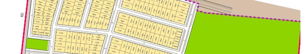
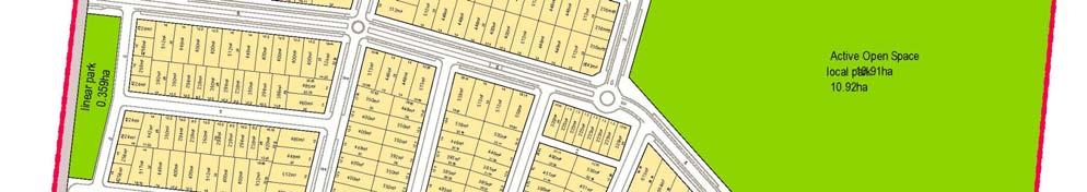
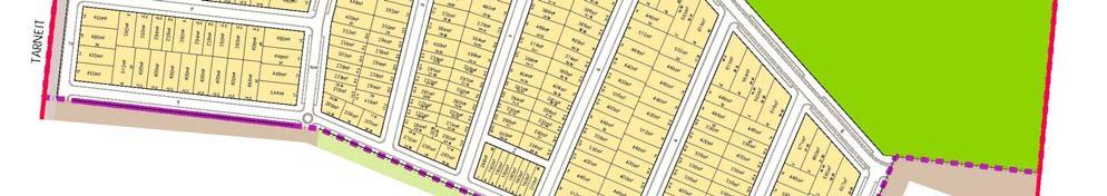
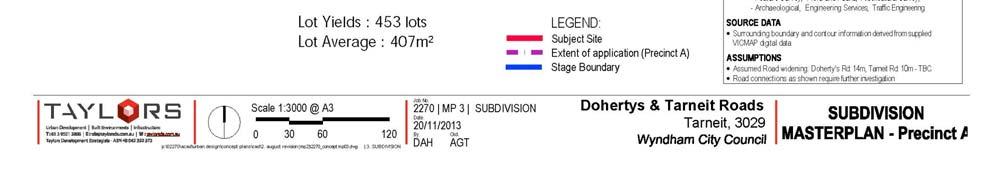
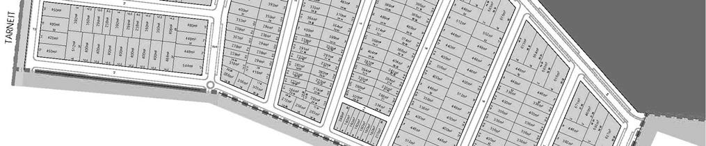
7 3 PROPOSED DEVELOPMENT The proposal is to subdivide the site to ultimately provide a total of approximately 453 residential allotments, including roads and paths consistent with current practice. Various open space will also be provided as part of the development. Ultimate site access for vehicles is proposed as follows:- a signalised intersection to Tarneit Road, approximately midway along the site s western boundary, a left-in/left-out intersection to Tarneit Road at the north-west corner of the site, and via several connections that will be available with adjacent land to the north, east, and south of the site once adjacent land has also been developed. A plan of the proposed subdivision is attached at Appendix A. 4 INTERNAL TRAFFIC MATTERS 4.1 Traffic Generation and Road Hierarchy The RTA Guide to Traffic Generating Developments (2002) (RTA Guide) sets out traffic generation rates based on survey data collected in New South Wales for a range of land uses. This guide is used by VicRoads and is generally regarded as the standard for metropolitan development characteristics. The RTA Guide sets out the following rates for standard residential dwellings: daily vehicle trips = 9.0 per dwelling weekday peak hour vehicle trips = 0.85 per dwelling However the RTA Guide states that... The Australian Model Code for Residential Development (AMCORD) assumes a daily vehicle generation rate of 10.0 per dwelling, with 10% of that taking place in the commuter peak period. The use of these figures provides some allowance for later dual occupancy development. If we conservatively adopt a rate of 10 vehicle trip-ends (vte) per day then it would be expected that no more than 4,530 daily vte would be generated by the proposed subdivision. Of these, we will conservatively assume that in the order of 10% would be generated during each of the AM and PM peak hours 1. This results in a traffic generation of 453 vte during each of the peak hours. Based on the above, a road hierarchy plan for internal roads has been prepared when having consideration for the identified road layout and connections with the external road network. This is attached at Appendix B. 1 Previous experience with residential subdivisions indicate that less than 10% of daily traffic is generated during each of the commuter peak hours in outer metropolitan areas such as this R#1 Page 4

8 4.2 Road Cross-Sections All road reservations are identified to ensure that the future characteristics of each street are generally in accordance with Clause of the Wyndham Planning Scheme and current practice. Each of the proposed road/street types are outlined below Connector Streets (Avenue 1 & Avenue 2) An entry Connector Street (Avenue 1) is proposed to run in an east-west orientation between Tarneit Road and the western boundary of the large Active Open Space that is proposed at the eastern side of the site. This road is identified with a total road reservation width of 28m. This road reservation would provide dual carriageways that accommodate a 3.5m wide traffic lane, 1.7m wide bicycle lane and 2.3m wide parking lane in each direction. This road reservation width is sufficient to accommodate all necessary road user groups including the provision of 1.5m wide footpaths on each side of the road and is shown in Figure 7. Figure 7: Connector Road (Avenue 1) cross-section Another form of Connector Street (Avenue 2) is proposed adjacent to the eastern side of the site s southern boundary. This road is proposed to have a total road reservation of 24.5m and a cross-section that is virtually the same as the entry Connector Street with the exception of no bicycle lanes Connector Street (Street 2) A Connector Street (Street 2) is proposed adjacent to the large Active Open Space that is proposed at the eastern side of the site. This road is proposed to have a total road reservation width of 24m. This road reservation provides for a 3.5m wide traffic lane, 1.7m wide bicycle lane and 2.3m wide parking lane in each direction R#1 Page 5
 is shown in Figure 8. Figure 8: Connector Street (Street 2) Cross-Section 4.2.3 Access Street (Street 1) Three (3) Access Streets (Street 1) are proposed throughout the site.")
9 This road reservation width is sufficient to accommodate all necessary road user groups including the provision of 1.5m wide footpaths on each side of the road. A cross-section of the proposed Connector Street (Street 2) is shown in Figure 8. Figure 8: Connector Street (Street 2) Cross-Section Access Street (Street 1) Three (3) Access Streets (Street 1) are proposed throughout the site. These roads are proposed to have a total road reservation width of 20.6m. This road reservation provides for a 3.5m wide traffic lane and 2.3m wide parking lane in each direction. This road reservation width is sufficient to accommodate all necessary road user groups including the provision of 1.5m wide footpaths on each side of the road. A cross-section of the proposed Access Street (Street 1) is shown in Figure 9Figure R#1 Page 6
 The majority of streets within the proposed subdivision are proposed to be Access Streets (Local Road) and are shown to have 16m wide road reservations.")
10 Figure 9: Access Street (Street 1) Cross-Section Access Street (Local Road) The majority of streets within the proposed subdivision are proposed to be Access Streets (Local Road) and are shown to have 16m wide road reservations. These road reservations are sufficient to accommodate all relevant road user groups. The proposed carriageway width of 7.3m for these roads can accommodate parking on both sides of the road and a single though lane of traffic. Alternatively, simultaneous two-way traffic can be accommodated when vehicles are parked on one side of the road only. Footpaths (1.5m wide) are to be provided on both sides of all of these roads. A cross-section of the proposed Access Street (Local Road) is shown in Figure R#1 Page 7

11 Figure 10: Access Street (Local Road) Cross-Section Access Place (Reserve/Service Road) Some Access Places (Reserve/Service Road) are also proposed within the subdivision. Each of these roads are proposed adjacent to local park/reserve and are shown to have a road reservation of 13m. These road reservations are sufficient to accommodate all relevant road user groups. The proposed carriageway width of 5.5m for these roads can accommodate parking on one side of the road and a single though lane of traffic. Alternatively, simultaneous two-way traffic can be accommodated when there are no vehicles parked. Footpaths (1.5m wide) are to be provided on one side of the road only. Footpaths on the other side of the road can be suitably accommodated within the adjacent local park/reserve where relevant. A cross-section of the proposed Access Place (Reserve/Service Road) is shown in Figure R#1 Page 8

12 Figure 11: Access Place (Reserve/Service Road) Cross-Section Laneway Some laneways are also proposed within the site at the rear of allotments. These are proposed with a 6.5m wide road reservation including a 6m wide carriageway, in excess the Planning Scheme requirements for an Access Lane. This carriageway width accommodates simultaneous two-way traffic and no parking which is an acceptable outcome given that associated allotments also have abuttal to an adjacent frontage road and/or side where on-street parking is possible. A cross-section of the proposed Laneway is shown in Figure R#1 Page 9
 are proposed with a carriageway width of 7.3m wide which allows parking to readily occur on both sides of the road whilst maintaining a through lane for traffic.")
13 4.3 Parking Provision Figure 12: Laneway Cross-Section Parallel parking lanes will be provided on each side of the Connecter Streets and Access Streets (Street 1). Access Streets (Local Road) are proposed with a carriageway width of 7.3m wide which allows parking to readily occur on both sides of the road whilst maintaining a through lane for traffic. Alternatively, simultaneous two-way traffic would be possible if parking occurred on only one side of these roads. Parking will also be available along one side of Access Place (Reserve/Service Road) roads which is suitable given that residential abuttal will be provided on only one side of these streets. 4.4 Access for Service and Emergency Vehicles The 7.3m wide carriageway for Access Streets (Local Road) will adequately facilitate the relevant service and emergency vehicles and are consistent with the typical CFA requirements. This is similarly the case for the Access Place (Reserve/Service Road) streets which have a 5.5m wide carriageway but allows parking on one side of the road only. The proposed laneways which provide a 6.0m wide carriageway with no parking allowed will also adequately accommodate service and emergency vehicles. Furthermore, all allotments with laneway access are to also have abuttal to a frontage and/or side road which would be suitable for the placement of bins for associated collection by Council s standard refuse vehicles. All other proposed road have a cross-section with a 3.5m wide through lane (in each direction) clear of any bicycle and/or parking lanes which will also readily facilitate service and emergency vehicles. No dead-end roads are proposed in the development. Accordingly, the development does not require any turning provisions. However, we note that some consideration may 16740R#1 Page 10
14 be necessary in relation to service and emergency vehicles when specific stages are being constructed. 4.5 Pedestrian and Cycling Access Footpaths, shared paths and bicycle lanes are to be provided in accordance with the requirements of the Wyndham Planning Scheme. This includes: Footpaths (as a minimum) on both sides of the development s internal roads (excluding laneways) or within adjacent local reserves where relevant, and On-road bicycle lanes on Avenue 1 and Street 2 Connector Streets. These will provide connections with adjacent land at a level that is consistent with the objectives of the Wyndham Planning Scheme and current practice, and will be appropriate to serve the proposed residential development. 4.6 Public Transport Considerations A bus network plan of the area will likely be developed as part of the Tarneit North PSP. It is likely that a potential future bus route will run adjacent to the site along Tarneit Road. It is also possible that a potential bus route(s) will operate through the site along the higher order road network which is appropriately identified to facilitate buses in accordance with current standards. If this is the case, any traffic control treatment that is provided along this route should be designed to ensure that buses can be accommodated. This potential level of public transport will ensure that all future dwellings in the development are within an acceptable walking distance of a bus route (less than 400m) at a level that is consistent with current objectives. 4.7 Traffic Control Clause of the Planning Scheme suggests that it is desirable for street blocks to be no more than approximately 240m long in order to facilitate pedestrian movement and control traffic speed. Having said this, it is not uncommon or inappropriate for higher order roads to be between m long between speed devices. The proposed subdivision, which includes the provision of a number of roundabouts that are identified along either the entry Connector Road (Avenue 1) or the central northsouth Access Street (Street 1), is generally in accordance with the above with a few exceptions as follows: The north-south aligned Access Street (Local Road) within the north-west portion of the site. A reverse priority T-intersection is suggested on this street. The north-south aligned Access Street (Local Road) located approximately midway along the site s southern boundary. A reverse priority T-intersection is suggested on this street. The central north-south Access Street (Street 1) towards the northern boundary of the site. A reverse priority T-intersection is suggested on this street. The Access Street (Street 2)/Access Street (Street 1) intersection at the eastern site boundary immediately south of the Active Open Space. A roundabout or some form of T-intersection treatment is suggested at the intersection. The suggested traffic control devices are shown in Figure 13. It is also noted that staggered T-intersections are appropriately separated throughout the site. The Access Street (Street 1)/Access Street (Local Road) cross-intersection that is located in the northern part of the site is expected to have minimal east-west through 16740R#1 Page 11
.")
15 movements and we are satisfied that standard Statcon controls (Give Way signs and linemarking) would be appropriate on both the eastern and western leg in order to provide priority to motorists travelling along the north-south orientated Access Street (Street 1). Reversed Priority T-intersections Roundabouts Roundabout Reversed Priority T-intersection T-treatment or Roundabout Figure 13: Suggested Traffic Control Devices 5 EXTERNAL ACCESS CONSIDERATIONS The primary access point for the proposed residential subdivision will be located approximately mid-way along the site s western boundary via Tarneit Road. This site s primary access point is also well located in relation to Dohertys Road and the grade separation of the railway line, being approximately midway between the two. This intersection will likely be signalised under ultimate conditions and the provision of splays and flares will likely be needed in addition to the standard Tarneit Road reservation in order to accommodate associated turn lanes. A secondary site connection is proposed via Tarneit Road at the site s north-west corner. This connection is also well located, being approximately halfway between Dohertys Road to the 16740R#1 Page 12
16 north and the main site connection as proposed to the south. In the ultimate when Tarneit Road is duplicated, this secondary access may be restricted to left-in and left-out (and perhaps rightin) movements only. However, subject to suitable turn lanes being provided, we see no reason to suggest why all movements couldn t be accommodated under the interim (existing) Tarneit Road configuration if desired. 6 CONCLUSIONS Having visited the site, perused relevant documents and plans, predicted traffic generation, provided design advice to the internal layout and associated connections to the abutting road network, and undertaken other traffic engineering assessments, we are of the opinion that:- a) the proposed road reservations are consistent with what is required to accommodate appropriate carriageways, footpaths, services, etc. in accordance with the relevant standards, and current practice, b) public transport, on-street parking, pedestrian and cycle provisions are identified in a manner that is at least consistent with the Planning Scheme requirements, relevant standards, and current practice, c) all relevant vehicles will be able to adequately access the site including service and emergency vehicles subject to consideration for potential interim arrangements at any temporary dead-ends that may eventuate depending on staging within the development, d) traffic predicted to be generated by the proposed development will easily be accommodated by the ultimate road network and intersections without any adverse impacts, e) traffic control devices similar to those presented at Figure 13 of this report should be considered on the internal road network to control speed in a fashion consistent with current practice, and f) there are no traffic engineering reasons why a permit should not be granted for the proposed residential subdivision at Part of Tarneit Road & 1121 Dohertys Road, Tarneit R#1 Page 13
17 Appendix A Development Plan 16740R#1


18 16740R#1
19 Appendix B Road Hierarchy Plan 16740R#1


20 LEGEND Avenue 1 Avenue 2 Street 2 Street 1 Local road Reserve/Service Road Laneway 16740R#1
Traffic and Transport Assessment
 Traffic and Transport Assessment Section 96 Residential Subdivision, Davis Road Tarneit CG120370 Prepared for Stockland Pty Ltd 19 February 2013 Document Information Prepared for Stockland Pty Ltd Project
BROMPTON LODGE, CRANBOURNE PRECINCT STRUCTURE PLAN TRAFFIC ENGINEERING ASSESSMENT WOLFDENE PTY LTD PREPARED FOR
 BROMPTON LODGE, CRANBOURNE PRECINCT STRUCTURE PLAN TRAFFIC ENGINEERING ASSESSMENT PREPARED FOR WOLFDENE PTY LTD TRAFFIC ENGINEERING ASSESSMENT PRECINCT STRUCTURE PLAN AT BROMPTON LODGE, CRANBOURNE Document
Minta Farm Berwick S96A Transport Impact Assessment
 Minta Farm Berwick S96A Transport Impact Assessment 170310TIA001I-F 4 October 2017 onemilegrid ABN: 79 168 115 679 (03) 9939 8250 1/59 Keele Street COLLINGWOOD, VIC 3066 www.onemilegrid.com.au DOCUMENT
Daleston Masterplan Traffic & Transport Assessment
 ` Daleston Masterplan Job Number: CG111723 Daleston Masterplan Cardno Victoria Pty Ltd ABN 47 106 610 913 150 Oxford Street, Collingwood Victoria 3066 Australia Telephone: 03 8415 7777 Facsimile: 03 8415
Barwon Heads Road, Armstrong Creek Traffic Impact Assessment Prepared for: Newland Developers Pty Ltd
 892 990 Barwon Heads Road, Armstrong Creek Traffic Impact Assessment Prepared for: Newland Developers Pty Ltd JULY 2015 TABLE OF CONTENTS 1 INTRODUCTION... 1 1.1 BACKGROUND... 1 1.2 SCOPE... 1 1.3 AIM
1 VicRoads Access Management Policies May 2006 Ver VicRoads Access Management Policies May 2006 Version 1.02
 1 VicRoads Access Management Policies May 2006 Ver 1.02 VicRoads Access Management Policies May 2006 Version 1.02 2 VicRoads Access Management Policies May 2006 Ver 1.02 FOREWORD FOR ACCESS MANAGEMENT
10 SHERFORD Town Code
 Key Fixes (Ref: Masterplan Book, section 4a. Land Use Budget and Key Fixes ) The Town Plan designs and allocates buildings, streets and spaces as accurately as possible in the understandable absence of
STATEMENT TO PLANNING PANELS VICTORIA BY WILLIAM DE WAARD, TRAFFIC ENGINEER
 Amendment C228 to the Casey Planning Scheme Traffic Engineering Assessment Planning Panels Victoria Panel Hearing Date: Monday 16 th April, 2018 Report Date: 5 th April, 2018 Prepared for the Applicant:
Traffic Engineering Assessment. Additional Traffic Modelling at Minta Farm PSP 11. Prepared for Victorian Planning Authority
 Additional Traffic Modelling at Minta Farm PSP 11 Prepared for Victorian Planning Authority Traffic Engineering Assessment Additional Traffic Modelling at Minta Farm PSP 11 Document Control Issue No. Type
Proposed Residential & Retail Development at Geelong Rd Portarlington
 Batman Invest Traffic Impact Assessment Proposed Residential & Retail Development at 30-32 Geelong Rd Portarlington Batman Invest Traffic & Parking Impact Assessment for Proposed Residential & Retail Development
IMPLEMENTATION GUIDELINE NO. 13
 IMPLEMENTATION GUIDELINE NO. 13 Provision of Electricity, Driveways and Crossovers, Footpaths, Kerb and Channel Date of Council Resolution These guidelines were adopted by Council on 13 October 2009, and
HANNA STREET, NOBLE PARK PROPOSED RESIDENTIAL REZONING TRAFFIC ENGINEERING ASSESSMENT YARRAMAN PARK DEVELOPMENTS PREPARED FOR JUNE, 2012
 48-146 HANNA STREET, NOBLE PARK PROPOSED RESIDENTIAL REZONING TRAFFIC ENGINEERING ASSESSMENT PREPARED FOR YARRAMAN PARK DEVELOPMENTS JUNE, 2012 14034R#1 TRAFFIC ENGINEERING ASSESSMENT PROPOSED RESIDENTIAL
Growth Areas Authority 31 May Wyndham North Traffic Modelling and SIDRA Analysis
 Growth Areas Authority 31 May 213 Wyndham North Traffic Modelling and SIDRA Analysis AECOM Wyndham North Traffic Modelling and SIDRA Analysis Wyndham North Traffic Modelling and SIDRA Analysis Prepared
PLAN 20 PUBLIC TRANSPORT NETWORK
 KEY Bus Route / 400m Coverage Existing Recommended Secondary Potential Secondary Indicative Stop Locations Principle Standard Sub-regional Transit Corridor Reservation PLAN 0 PUBLIC TRANSPORT NETWORK Date:
Traffic Modelling Report
 CG150713 Prepared for Metropolitan Planning Authority 28 September 2015 Document Information Prepared for Metropolitan Planning Authority Project Name File Reference CG150713REP001F01.docx Job Reference
Ministry of Education Flat Bush School Notice of Requirement. Integrated Transportation Assessment Report. February 2016
 Ministry of Education Flat Bush School Notice of Requirement Integrated Transportation Assessment Report February 2016 TDG Ref: 12988-2 151105 ita flat bush.docx Ministry of Education Flat Bush School
Appendix 5 Traffic Assessment
 Appendix 5 Traffic Assessment 44 Harrison Transportation Best Start Educare Shelly Bay Road Beachlands Transportation Assessment Report September 2017 PO Box 11 557 Palm Beach Papamoa 3151 Reference: 187
Transit boulevard: A new road type for Sydney s Growth Centres
 Transit boulevard: A new road type for Sydney s Growth Centres Cleaver, M. A., de Roos, M. P., NSW Centre for Road Safety, Roads and Traffic Authority, NSW Collins, G., Network Services, Roads and Traffic
Minta Farm Precinct Structure Plan
 Minta Farm Precinct Structure Plan Concept Road Design Report Client: Victorian Planning Authority Project No. 161910 Final Report 05/10/17 1 st Floor 132 Upper Heidelberg Road Ivanhoe Vic 3079 PO Box
Berwick Health and Education Precinct: Casey Amendment C207 (Part 1) Submission to Planning Panels Victoria
 Submission to Planning Panels Victoria") Berwick Health and Education Precinct: Casey Amendment C207 (Part 1) Submission to Planning Panels Victoria August 2018 CONTENTS 1 Executive summary... 1 2 Summary of the amendment... 2 3 Submission...
Berwick Health and Education Precinct: Casey Amendment C207 (Part 1) Submission to Planning Panels Victoria August 2018 CONTENTS 1 Executive summary... 1 2 Summary of the amendment... 2 3 Submission...
Response to further information request Ministry of Education Notice of Requirement (200 & 252 Park Estate Road)
") 21 Pitt Street PO Box 6345, Auckland 1141, New Zealand T: +64 9 300 9000 // F: +64 9 300 9300 E: info@beca.com // www.beca.com Auckland Council Private Bag 92300 Victoria Street West Auckland 1142 15 August
21 Pitt Street PO Box 6345, Auckland 1141, New Zealand T: +64 9 300 9000 // F: +64 9 300 9300 E: info@beca.com // www.beca.com Auckland Council Private Bag 92300 Victoria Street West Auckland 1142 15 August
EXECUTIVE SUMMARY Callan Park accommodates travel from a wide range of transport modes, including walking, cycling, bus and light rail.
 TRANSPORT AND ACCESS EXECUTIVE SUMMARY Callan Park accommodates travel from a wide range of transport modes, including walking, cycling, bus and light rail. Whilst there are some walking facilities within
CHECKLIST 2: PRELIMINARY DESIGN STAGE AUDIT
 CHECKLIST 2: PRELIMINARY DESIGN STAGE AUDIT 2.1 General topics 2.1.1 Changes since previous audit Do the conditions for which the scheme was originally designed still apply? (for example, no changes to
Report from Embassy Visit to Copenhagen May David Arditti
 Report from Embassy Visit to Copenhagen May 2013 David Arditti Standard CPH cycle track, one-way 1.5 2m wide, 5cm above carriageway, 5cm below footway Basic one-way cycle track protected by car parking
MILTON ROAD LLF PROJECT UPDATE
 Greater Cambridge City Deal MILTON ROAD LLF PROJECT UPDATE 9 th May 2017 Project objectives Comprehensive priority for buses in both directions wherever practicable; Additional capacity for sustainable
TGSI Tactile Ground Surface Indicators
 TGSI Tactile Ground Surface Indicators Introduction: This Design Note, No 11, provides guidelines and requirements for the use and installation of Tactile Ground Surface Indicators (TGSI s). References
Public Consultation on Braintree Integrated Transport Package (ITP) HAVE YOUR. Consultation open from 24 September to 5 November 2018 SAY
 HAVE YOUR. Consultation open from 24 September to 5 November 2018 SAY") Public Consultation on Braintree Integrated Transport Package (ITP) HAVE YOUR SAY Consultation open from 24 September to 5 November 2018 Contents Introduction 3 Background 4 Springwood Drive Roundabout
Public Consultation on Braintree Integrated Transport Package (ITP) HAVE YOUR SAY Consultation open from 24 September to 5 November 2018 Contents Introduction 3 Background 4 Springwood Drive Roundabout
Appendix A Maunsell Traffic Report
 Appendix A Maunsell Traffic Report Mooroopna West Growth Corridor Structure Plan T:\300 232 04 Mooroopna West ODP\3.0 Deliverables\July 2009 Reports\Structure Plan\Mooroopna West Growth Corridor Structure
Harriet Fraser Traffic Engineering & Transportation Planning
 Appendix 5: Traffic Assessment 71 26 February 2015 Mr James Beban Senior Resource Consents Planner Cuttriss Consultants Ltd PO Box 30429 Lower Hutt PO Box 40170 Upper Hutt 5140 P 04 526 2979 M 027 668
RÉGION D OTTAWA-CARLETON
 8 REGION OF OTTAWA-CARLETON RÉGION D OTTAWA-CARLETON REPORT RAPPORT Our File/N/Réf. Your File/V/Réf. 50 23-00-R030-H DATE 14 July 2000 TO/DEST. FROM/EXP. SUBJECT/OBJET Co-ordinator Transportation Committee
2. executing a legal agreement with respect to the above.
 2. MODIFICATIONS TO INNES ROAD AND BLAIR ROAD INTERSECTION TO ACCOMMODATE THE CONSTRUCTION OF THE INNES CENTRE - PUBLIC HEARING COMMITTEE RECOMMENDATION Having held a public hearing, that Council approve
Ministry of Education Notice of Requirement, North City High School. Transportation Assessment Report. July 2010
 Ministry of Education Notice of Requirement, North City High School Transportation Assessment July 2010 PO Box 1261, Level 1, 7 Hardley Street Hamilton 3240 P: +64 7 839 550 www.tdg.co.nz New Zealand 10574ta_v6.doc
CITY OF VAUGHAN EXTRACT FROM COUNCIL MEETING MINUTES OF OCTOBER 30, 2012
 CITY OF VAUGHAN EXTRACT FROM COUNCIL MEETING MINUTES OF OCTOBER 30, 2012 Item 31, Report No. 39, of the Committee of the Whole, which was adopted without amendment by the Council of the City of Vaughan
A5.1 Permitted activities
 Section A5 Transportation A5.1 Permitted activities A5.1.1 Activities within roads Note: Refer to Section D for the definition of road (a) Any activity associated with the movement of traffic and the functioning
Table of Contents... i. 1. Introduction Proposed Amendment C162 (Mt Atkinson and Tarneit Plains PSP) Overview...
 Overview...") TABLE OF CONTENTS Table of Contents... i 1. Introduction... 1 2. Proposed Amendment C162 (Mt Atkinson and Tarneit Plains PSP)... 2 2.1. Overview... 2 2.2. Design Principles & Relevant Guideline Documents...
TABLE OF CONTENTS Table of Contents... i 1. Introduction... 1 2. Proposed Amendment C162 (Mt Atkinson and Tarneit Plains PSP)... 2 2.1. Overview... 2 2.2. Design Principles & Relevant Guideline Documents...
Amendments to Essex Highway Maintenance Strategy Maintenance Policy and Standards April 2008
 Amendments to Essex Highway Maintenance Strategy Maintenance Policy and Standards April 2008 The following amendments to the wording of the maintenance strategy apply following the revised maintenance
City of Perth Cycle Plan 2029
 Bicycling Western Australia s response City of Perth Cycle Plan 2029 2012-2021 More People Cycling More Often ABOUT BICYCLING WESTERN AUSTRALIA Bicycling Western Australia is a community based, not-for-profit
13M /09/13. St Germain Special Activity Precinct 1425 Pound Road & 2100 Thompsons Road Clyde North Transport Impact Assessment.
 St Germain Special Activity Precinct 1425 Pound Road & 2100 Thompsons Road Clyde North Transport Impact Assessment d r a f t TIA/RSAMA VIC (130603 v7.2)) St Germain Special Activity Precinct 1425 Pound
St Germain Special Activity Precinct 1425 Pound Road & 2100 Thompsons Road Clyde North Transport Impact Assessment
 St Germain Special Activity Precinct 1425 Pound Road & 2100 Thompsons Road Clyde North Transport Impact Assessment St Germain Special Activity Precinct 1425 Pound Road & 2100 Thompsons Road, Clyde North
4. ENVIRONMENTAL IMPACT ANALYSIS 9. TRANSPORTATION AND TRAFFIC
 4. ENVIRONMENTAL IMPACT ANALYSIS 9. TRANSPORTATION AND TRAFFIC 4.9.1 INTRODUCTION The following section addresses the Proposed Project s impact on transportation and traffic based on the Traffic Study
1.5 On this basis it is fundamental that the Transport Strategy for the site focuses on the following key criteria,
 1.0 Introduction 1.1 The Transport Assessment has been prepared on behalf of Eon and Roger Bullivant Ltd in respect of the proposed mixed use sustainable urban extension of Drakelow Park. 1.2 The methodology
Shotover Country. Proposed Private Plan Change. Transportation Assessment Report. February 2010
 Shotover Country Proposed Private Plan Change February 2010 PO Box 13 835, Armagh Christchurch 8141 P: +64 3 379 2404 www.tdg.co.nz New Zealand Shotover Country Proposed Private Plan Change Quality Assurance
Classification Criteria
 SCHEDULE D TO RECOMMENDED OFFICIAL PLAN AMENDMENT NO. 40 SCHEDULE C-4 Road Criteria Criteria Traffic Service Objective Land Service/Access Typical Daily Traffic Volume Flow characteristics Travel Speed
Amendment C369 to the Greater Geelong Planning Scheme: Drysdale Bypass
 Amendment C369 to the Greater Geelong Planning Scheme: Planning Panels Victoria Panel Hearing Date: Friday 27 th July, 2017 Report Date: 20 th July, 2017 Prepared For: VicRoads Instructed By: HWL Ebsworth
Frome Street Bicycle Route
 The Adelaide City Council invites engagement from the community about Frome Street Bicycle Route Project Summary Adelaide City Council is seeking feedback on design options to construct bicycle facilities
A127/A130 Fairglen Interchange Improvement Schemes. Information Leaflet February 2017
 A127/A130 Fairglen Interchange Improvement Schemes Information Leaflet February 2017 1 2 Foreword By Councillor Kevin Bentley Essex is continuing to grow as a vibrant economic hub and as a fantastic place
RAA Submission to: The City of Adelaide Draft Integrated Movement Strategy Moving Adelaide
 RAA Submission to: The City of Adelaide Draft Integrated Movement Strategy 2012-22 Moving Adelaide May 2012 RAA Submission to the City of Adelaide Draft Integrated Movement Strategy 2012-22 Moving Adelaide
MEETING FACILITY 2901 GIBFORD DRIVE CITY OF OTTAWA TRANSPORTATION BRIEF. Prepared for: Holiday Inn Express 2881 Gibford Drive Ottawa, ON K1V 2L9
 MEETING FACILITY 2901 GIBFORD DRIVE CITY OF OTTAWA TRANSPORTATION BRIEF Prepared for: Holiday Inn Express 2881 Gibford Drive Ottawa, ON K1V 2L9 December 18, 2012 112-566 Brief_1.doc D. J. Halpenny & Associates
BLYTHEWOOD PARK, BROMLEY
 BLYTHEWOOD PARK, BROMLEY Proposed Access Junction to Serve a Single Residential Dwelling On behalf of Robert Pooke CONTENTS Introduction...1 Appeal Site and Planning History...2 Relevant Transport Policy...4
Frascati Road and Temple Hill Route Improvements. Outline Design Report to Accompany Public consultation
 Frascati Road and Temple Hill Route Improvements Outline Design Report to Accompany Public consultation September 2013 Background: Dún Laoghaire-Rathdown is committed to providing high quality pedestrian
CITY OF OTTAWA ROADWAY MODIFICATION APPROVAL UNDER DELEGATED AUTHORITY
 RMA-2015-ATM-038 CITY OF OTTAWA ROADWAY MODIFICATION APPROVAL UNDER DELEGATED AUTHORITY DATE: April 22, 2015 SUBJECT Approval of Roadway Modifications Recommended through an Area Traffic Management Study
CURRENT ORIGINAL REFERENCE SECTIONS. (Typical Section) (Typical Section) The Parade Island Bay : Concept Option Summary Sheets.
 (Typical Section) The Parade Island Bay : Concept Option Summary Sheets.") ORIGINAL (Typical Section) CURRENT (Typical Section) 3,900 3,000 2,000 1,500 3,100 1,600 3,100 1,500 2,000 2,500 3,900 3,000 1,800 600 2,000 3,000 3,000 2,000 600 1,800 2,500 Existing Planting Traffic
ORIGINAL (Typical Section) CURRENT (Typical Section) 3,900 3,000 2,000 1,500 3,100 1,600 3,100 1,500 2,000 2,500 3,900 3,000 1,800 600 2,000 3,000 3,000 2,000 600 1,800 2,500 Existing Planting Traffic
Precinct 15 Blackshaws Road Altona North Development / Structure Plan Transport Assessment
 Precinct 15 Blackshaws Road Altona North Development / Structure Plan Transport Assessment 14M1544000 23/03/15 Precinct 15 Blackshaws Road, Altona North Development / Structure Plan Transport Assessment
The Wincheap Society
 The Wincheap Society s on sections of: Thanington 4th Arm Slip Road, Walking, Cycling & Horse-Riding Assessment & Review Report, by Peter Brett Associates, October 2017, on behalf of Pentland Properties
The Rower Traffic Management Scheme
 KILKENNY COUNTY COUNCIL Comhairle Chontae Chill Chainnigh Section 38 of the Road Traffic Act, 1994 as amended by the Public Transport Regulation Act, 2009 (Section 46) The Rower Traffic Management Scheme
Acland Street, St Kilda
 Acland Street, St Kilda Traffic Redistribution Client: Yarra Trams Project No. 122531 Draft_4 Report 16/09/13 Suite 1, 1 st Floor 132 Upper Heidelberg Road Ivanhoe Vic 3079 PO Box 417 Ivanhoe Vic 3079
Phone: Ref No: 06/2018/0884
 Development Directorate Preston City Council Town Hall Lancaster Road Preston PR1 2RL FAO Ben Sandover Phone: 01772 533855 Email: david.allen@lancashire.gov.uk Ref No: 06/2018/0884 Date: 20 September 2018
Prepared For: Shieldbay Developments Inc. c/o Matson, McConnell Ltd. 2430A Bloor Street West Toronto, Ontario M6S 1P9.
 Prepared For: Shieldbay Developments Inc. c/o Matson, McConnell Ltd. 2430A Bloor Street West Toronto, Ontario M6S 1P9 Prepared By: URS Canada Inc. 4 th Floor, 30 Leek Crescent Richmond Hill, Ontario L4B
SCHEME DESIGN AND ENGINEERING
 THE NORTH SOMERSET COUNCIL (SOUTH BRISTOL LINK CLASSIFIED ROAD) SIDE ROADS ORDER 2013 THE NORTH SOMERSET COUNCIL (SOUTH BRISTOL LINK) COMPULSORY PURCHASE ORDER 2013 THE NORTH SOMERSET COUNCIL (SOUTH BRISTOL
Potential Bicycle Facility on Bayou Street Mobile, Alabama
 Potential Bicycle Facility on Bayou Street Mobile, Alabama By Richard A. Hall, P.E. Prepared For Mobile Downtown Alliance Hall Planning & Engineering, Inc. March 28, 2018 Introduction Review of the February
APPENDIX G: INTERSECTION NEEDS AT OKEECHOBEE BOULEVARD
 APPENDIX G: INTERSECTION NEEDS AT OKEECHOBEE BOULEVARD INTERSECTION NEEDS AT SR 7 and OKEECHOBEE BOULEVARD SR 7 Extension Project Development and Environment (PD&E) Study From Okeechobee Boulevard (SR
6. BREENS/GARDINERS/HAREWOOD INTERSECTION - SAFETY IMPROVEMENT PROJECT
 6. BREENS/GARDINERS/HAREWOOD INTERSECTION - SAFETY IMPROVEMENT PROJECT General Manager responsible: Officer responsible: Author: Jane Parfitt General Manager City Environment DDI 941 8656 Michael Aitken
Sixth Line Development - Transit Facilities Plan
 Memorandum Date: November 13, 2012 To: From: c.c. Subject: Rob Freeman (Freeman Planning) Kevin Phillips Sixth Line Development - Transit Facilities Plan 33016631 This memo was prepared to review the transit
CUERDEN TRANSPORT PROPOSALS
 1 CUERDEN TRANSPORT PROPOSALS The transport assessment, submitted with the Cuerden development planning application, looks at access to the site and the impact on the local road network in detail. This
Transport Assessment. Curtis Street Plan Change
 Transport Assessment Curtis Street Plan Change Transport Assessment for Curtis Street Plan Change i Contents 1. Introduction... 1 2. Existing Conditions... 2 2.1 Location... 2 2.2 Study Area... 3 2.3
SC6.17 Planning scheme policy for the transport and parking code
 SC6.17 Planning scheme policy for the transport and parking code SC6.17.1 Purpose The purpose of this planning scheme policy is to:- (a) (b) (c) provide guidelines and advice about achieving outcomes in
TRANSPORT AND MOVEMENT
 TRANSPORT AND MOVEMENT Movement Strategy Public Transport Cycling and Walking Road Network Parking Standards Transport Impact Assessments Traffic Management Policies DRAFT POOLBEG PLANNING SCHEME Movement
North West Non-Technical Summary of the Transport Assessment September 2011
 North West Non-Technical Summary of the Transport Assessment September 2011 Introduction This is a Non-Technical Summary of the findings of the Transport assessment work undertaken for the proposed North
E4 Cycle Route Exeter University to Redhayes Bridge. - Recommendations from Exeter Cycling Campaign
 E4 Cycle Route Exeter University to Redhayes Bridge - Recommendations from Exeter Cycling Campaign 1.0 Introduction Exeter Cycling Campaign has prepared this report to provide recommendations for Devon
MACKA S SAND PTY LTD
 MACKA S SAND PTY LTD ROAD SAFETY AUDIT STAGE 2 PRELIMINARY DESIGN OF CHANNELISED INTERSECTION OF ACCESS ROAD TO TO PROPOSED SAND MINING DEVELOPMENT AT LOT 218, D.P. 1044608, WILLIAMTOWN AND NELSON BAY
DESIGN CODE. Enterprise West Harlow London Road North Design Code 21
 DESIGN CODE Enterprise West Essex @ Harlow London Road North Design Code 21 4 MAXIMUM BUILDING HEIGHTS 4.1 Table 4A sets out maximum building height standards for each character area within the LDO boundary.
Liveable Neighbourhoods Design Code and Policy
 CNU London Transportation Summit, November 2007 The West Australian Liveable Neighbourhoods Design Code and Policy Incorporating a New Urbanist Street Design Manual for New Communities Wendy Morris Ecologically
Appendix 3 Roadway and Bike/Ped Design Standards
 Appendix 3 Roadway and Bike/Ped Design Standards OTO Transportation Plan 2040 4/20/2017 Page A3-1 Adopted Standards The adopted OTO Design Standards and Major Thoroughfare Plan are contained herein.
Traffic Modelling and Intersection Analysis
 City of Whittlesea 4-Sep-4 Traffic Modelling and Intersection Analysis Wollert Precinct Structure Plan \\aumelfp\projects\698\6. Draft Docs\6. Reports\4-9-4 Final Report.docx Revision 4-Sep-4 Prepared
3.9 Recreational Trails and Natural Areas
 3.9 Recreational Trails and Natural Areas 3.9.1 Introduction Parks and other recreational facilities such as trails, bicycle routes, and open space are important community resources. This section discusses
INDUSTRIAL BUILDING 3009 HAWTHORNE ROAD CITY OF OTTAWA TRANSPORTATION OVERVIEW REVISED. Prepared for: Canada Inc.
 INDUSTRIAL BUILDING 3009 HAWTHORNE ROAD CITY OF OTTAWA TRANSPORTATION OVERVIEW REVISED Prepared for: 7849648 Canada Inc. Octiober 1, 2015 114-598 Overview_2.doc D. J. Halpenny & Associates Ltd. Consulting
Lyons Avenue/Dockweiler Road Extension Project Draft Environmental Impact Report. Appendix I Traffic Impact Study
 Lyons Avenue/Dockweiler Road Extension Project Draft Environmental Impact Report Appendix I Traffic Impact Study Street 0 80-1947 500.4501 RITA ld Court 0 91355-1096 400.7401 LA n Avenue 0 590-3745 300-9301
APPELLANT S STATEMENT OF CASE
 TOWN & COUNTRY PLANNING ACT 1990 (AS AMENDED) APPEAL BY FOCUS INTERNATIONAL CHRISTIAN CENTRE (FICC) AGAINST REFUSAL OF PLANNING PERMISSION BY THE LONDON BOROUGH OF HILLINGDON PLANNING PERMISSION IS SOUGHT
21.07 TRANSPORT CONNECTIVITY AND INFRASTRUCTURE
 21.07 TRANSPORT CONNECTIVITY AND INFRASTRUCTURE 21.07-1 Connectivity and Choice Transport connectivity and mode choice are critical to achieving productive, sustainable and socially just cities. Travel
Kings College, Otahuhu Proposed Plan Change. Integrated Transportation Assessment Report
 Proposed Plan Change Integrated Transportation Assessment Report 23 October 2017 Project: Report title: Document reference: Kings College, Otahuhu Integrated Transportation Assessment Report J00700 Kings
RESPONSIVE ROUNDABOUTS MYTH OR REALITY
 RESPONSIVE ROUNDABOUTS MYTH OR REALITY Andy Poole WSP UK Three White Rose Office Park Millshaw Park Lane Leeds LS11 0DL andy.poole@wspgroup.com Keywords: Traffic signals, optimisation, micro-simulation,
Pakenham East PSP 1210
 Pakenham East PSP 1210 Victorian Planning Authority Traffic and Transport: Expert Witness Statement Final C May 28, 2018 Pakenham East PSP 1210 Project No: Document Title: Document No.: Revision: IS245200
IMPLEMENTATION. PEDESTRIAN USERS (Continued /) Building Frontages: A: Stair Applications. Geometry (Accessed from the Sidewalk) Refer to A:
 Building Frontages: A: Stair Applications. Geometry (Accessed from the Sidewalk) Refer to A:") A: Stair Applications Building Frontages: Geometry (Accessed from the Sidewalk) Refer to A: Ramps should be provided for disabled users at 1:12 (8.3%) gradient. Ramp rises should be stepped at 400mm intervals.
A: Stair Applications Building Frontages: Geometry (Accessed from the Sidewalk) Refer to A: Ramps should be provided for disabled users at 1:12 (8.3%) gradient. Ramp rises should be stepped at 400mm intervals.
City of Wayzata Comprehensive Plan 2030 Transportation Chapter: Appendix A
 A1. Functional Classification Table A-1 illustrates the Metropolitan Council s detailed criteria established for the functional classification of roadways within the Twin Cities Metropolitan Area. Table
TRANSPORTATION NEEDS ASSESSMENT
 TRANSPORTATION NEEDS ASSESSMENT A travel demand analysis was carried out to determine the operational issues and the potential benefit that adding traffic capacity would have on the road network. All the
Loughborough University Travel Planning
 Document Ti tle Client Name Loughborough University Travel Planning Loughborough University Travel Plan Executive Summary 2015-2020 23 December 2015 Loughborough University Travel Planning Project no:
APPENDIX F: TECHNICAL NOTE 22 (VICARAGE ROAD JUNCTION)
") APPENDIX F: TECHNICAL NOTE 22 (VICARAGE ROAD JUNCTION) West Midlands Interchange Transport Assessment DCO Submission WEST MIDLANDS INTERCHANGE SUBJECT: Technical Note 22 Review of Vicarage Road Junction
APPENDIX F: TECHNICAL NOTE 22 (VICARAGE ROAD JUNCTION) West Midlands Interchange Transport Assessment DCO Submission WEST MIDLANDS INTERCHANGE SUBJECT: Technical Note 22 Review of Vicarage Road Junction
Woodward Hill Elementary School School Safety and Operation Review
 Address: 6082-142 nd Street Surrey, BC, V3X 1C1 Site Visit: March 7, 2011 Principal Anne Mackie Report Date: November 25, 2011 Phone: (604) 594-2408 Email: Mackie_A@sd36.bc.ca The following report is one
GLEN EIRA CITY COUNCIL. MURRUMBEENA Transforming our neighbourhood together our concepts based on your ideas
 GLEN EIRA CITY COUNCIL MURRUMBEENA Transforming our neighbourhood together our concepts based on your ideas 1 WHAT HAVE WE HEARD? WHAT NOW? Stage one Tell us what you love about your shopping strip November
4 & 4A Oaklands Road, Bromley, BR1 3SL TRANSPORT ASSESSMENT
 4 & 4A Oaklands Road, Bromley, BR1 3SL TRANSPORT ASSESSMENT Oaklands January 2015 4 & 4A Oaklands Road, Bromley, BR1 3SL TRANSPORT ASSESSMENT Oaklands January 2015 Registered Company Address: Mansion House
Recommended Roadway Plan Section 2 - Land Development and Roadway Access
 Recommended Roadway Plan Section 2 - Land Development and Roadway Access SECTION 2 Land Development and Roadway Access 2.1 Land Use and Access Management The Federal Highway Administration (FHWA) defines
Improving Cyclist Safety at the Dundas Street West and Sterling Road Intersection
 STAFF REPORT ACTION REQUIRED Improving Cyclist Safety at the Dundas Street West and Sterling Road Intersection Date: August 17, 2012 To: From: Wards: Reference Number: Public Works and Infrastructure Committee
At each type of conflict location, the risk is affected by certain parameters:
 TN001 April 2016 The separated cycleway options tool (SCOT) was developed to partially address some of the gaps identified in Stage 1 of the Cycling Network Guidance project relating to separated cycleways.
Terwillegar Drive Expressway Draft Concept Plan
 Terwillegar Drive Expressway Draft Concept Plan Anthony Henday Drive to Whitemud Drive November 28 5:00-8:00 p.m. December 1 10:00 a.m. - 3:00 p.m. Let s Talk Today you can: Learn about the new direction
Public Works and Infrastructure Committee. General Manager, Transportation Services
 STAFF REPORT ACTION REQUIRED Extending the Bay Street Bicycle Lanes Date: May 16, 2013 To: From: Public Works and Infrastructure Committee General Manager, Transportation Services Wards: Toronto Centre
Welcome. If you have any questions or comments on the project, please contact:
 Welcome This drop-in public open house is intended to provide information about the Bay Street bike lanes project. This project proposes a dedicated cycling facility along Bay Street between Aberdeen Avenue
Chapter 4 Route Window C3 Hyde Park and Park Lane shafts. Transport for London
 Chapter 4 Route Window C3 Hyde Park and Park Lane shafts Transport for London HYDE PARK AND PARK LANE SHAFTS 4 Route Window C3 Hyde Park and Park Lane shafts Introduction 4.1 In this route window, which
Highland Park Glengarry Court. Landscape design and Fencing rules
 Highland Park Glengarry Court Landscape design and Fencing rules Introduction Glengarry Court is to be developed as a comprehensive precinct with its own identity within Highland Park. This includes the
Statement of Evidence of Judith Makinson
 In the Matter of: The Resource Management Act 1991 and In the Matter of: Podium Sports Lodge, 18 20 Peake Road Application By: Brian Perry Charitable Trust Statement of Evidence of Judith Makinson TDG
Rhebogue Neighbourhood Greenway. Road Safety Audit Stage 2
 Rhebogue Neighbourhood Greenway Road Safety Audit Stage 2 Report Number: 12/007/00/00057 July 2014 Mid West National Road Design Office Lissanalta House, Dooradoyle County Limerick Tel: 061 496 800 Fax: