|
|
|
- Morgan Phillips
- 5 years ago
- Views:
Transcription
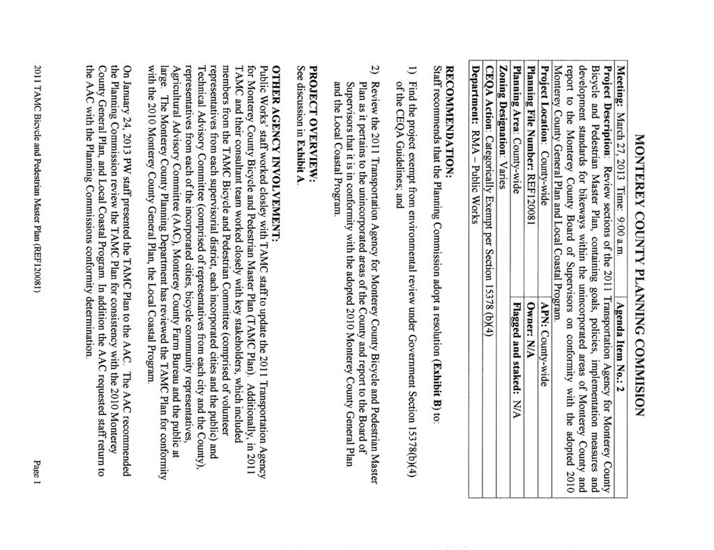
1
2

3
4
5
6
7

8 Transportation Agency for Monterey County Bicycle and Pedestrian Master Plan August 2011 PREPARED BY: Alta Planning + Design PREPARED FOR: Transportation Agency for Monterey County FUNDED IN PART BY: Monterey Bay Unified Air Pollution Control District
9 Transportation Agency for Monterey County Bicycle and Pedestrian Master Plan August 2011

10 Prepared for: Transportation Agency for Monterey County Funded in part by: Monterey Bay Unified Air Pollution Control District Prepared by: Alta Planning and Design
11 Acknowledgements TAMC Board of Directors Fernando Armenta, District 1 Louis Calcagno, District 2 Simon Salinas, 1 st Vice Chair, District 3 Jane Parker, District 4 Dave Potter, District 5 Jason Burnett, City of Carmel-By-The-Sea Jerry Edelen, City of Del Rey Oaks Maria Orozco, Chair, City of Gonzales John P. Huerta Jr., City of Greenfield Sue Kleber, City of King City Bruce Delgado, City of Marina Frank Sollecito, City of Monterey Robert Huitt, City of Pacific Grove Kimbly Craig, City of Salinas Steve Matarazzo, City of Sand City Felix Bachofner, City of Seaside Alejandro Chavez, City of Soledad Agency Staff Debbie Hale, Executive Director Don Bachman, P.E., Deputy Executive Director Kaki Cheung, Associate Transportation Planner Bicycle and Pedestrian Facilities Advisory Committee Eric Petersen, District 1 Dennis L. Johnson, District 2 Jeff Wriedt, District 4 Matthew Sundt, District 5 Dominick Askew, City of Marina Jan Roehl, City of Pacific Grove Judge Alan Hedegard, Vice Chair, City of Salinas William Randall, City of Seaside Jonathan Garcia, Fort Ord Reuse Authority David Craft, Monterey Bay Unified Air Pollution Control District Alexander Cappelli, Velo Club Alta Planning + Design Staff Michael Jones, Principal Jennifer Donlon, Project Manager Bruce Wolff, Planner Tony Salomone, GIS Analyst
12 TAMC Bicycle and Pedestrian Master Plan Table of Contents 1. Introduction Plan Purpose Vision, Goals, Objectives and Policies Public Involvement Existing Conditions Setting Land Use, Development and Activity Centers Transportation System Transit Bicycle Planning and Existing Bikeways in Monterey County Pedestrian Planning in Monterey County Planning and Policy Review Regional Planning Documents City Plans State Policies Needs Analysis Bicyclists General Needs and Preferences Pedestrians General Needs and Preferences Land Use and Demand for Bicycling and Walking Existing Bicycle and Pedestrian Activity Collision Analysis Benefits of Bicycling and Walking Air Quality Water Quality Reduced Dependence on Non-Renewable Resources Health Benefits Cost Savings and Economic Benefits Quality of Life Future Usage Bicycle Network and Projects Bicycle Parking and End-of-Trip Facilities County of Monterey Carmel-by-the-Sea Del Rey Oaks Gonzales Alta Planning + Design i
13 Table of Contents 6.6. Greenfield King City Marina City of Monterey Pacific Grove Salinas Sand City Seaside Soledad Caltrans California State Parks Pedestrian Improvements Countywide Pedestrian Priority Areas Project Lists and Categories Recommended Pedestrian Project Prioritization Criteria Project Implementation Bicycle Project Implementation Pedestrian Project Implementation Funding Federal State Regional Appendix A: Bicycle Design Guidelines... A-1 Appendix B: Pedestrian Design Guidelines... B-1 Appendix C: Bike Parking Tables... C-1 Appendix D: Bikeway Project Ranking... D-1 Appendix E: Bicycle Transportation Account Compliance... E-1 Appendix F: Project Sheets... F-1 Appendix G: Pedestrian Projects... G-1 Appendix H: Agricultural Resources... H-1 ii Alta Planning + Design
14 TAMC Bicycle and Pedestrian Master Plan Table of Figures Figure 1-1: Agency Bicycle and Pedestrian Facilities Advisory Committee Figure 2-1: Greater Monterey Peninsula Land Use Map Figure 2-2: North County Land Use Map Figure 2-3: South County Land Use Map Figure 2-4: Caltrans Bikeway Classifications Figure 2-5: Existing Bicycle Network Northern Monterey County Figure 2-6: Existing Bicycle Network Monterey Bay Area Figure 2-7: Existing Bicycle Network Southern Monterey County Figure 4-1: Bicyclist Typology Scale Figure 4-2: Bicycle and Pedestrian Attractors (North County) Figure 4-3: Bicycle and Pedestrian Attractors (South County) Figure 4-4: Bicycle Related Collisions Northern Monterey County Figure 4-5: Bicycle Related Collisions Peninsula Figure 4-6: Bicycle Related Collisions Southern Monterey County Figure 6-1: Monterey County Bikeway Projects (North) Figure 6-2: Monterey County Bikeway Projects (Peninsula) Figure 6-3: Monterey County Bikeway Projects (South) Figure 6-4: Carmel-by-the-Sea Bikeway Projects Figure 6-5: Del Rey Oaks Bikeway Projects Figure 6-6: Gonzales Bikeway Projects Figure 6-7: Greenfield Bikeway Projects Figure 6-8: King City Bikeway Projects Figure 6-9: Marina Bikeway Projects Figure 6-10: City of Monterey Bikeway Projects Figure 6-11: Pacific Grove Bikeway Projects Figure 6-12: Salinas Bikeway Projects Figure 6-13: Sand City Bikeway Projects Figure 6-14: Seaside Bikeway Projects Figure 6-15: Soledad Bikeway Projects Figure 7-1: Northern County AMBAG Blueprint Priority Areas Figure 7-2: Southern County AMBAG Blueprint Priority Areas Figure 7-3: County of Monterey (Moss Landing) Pedestrian Projects Figure 7-4: County of Monterey (Las Lomas) Pedestrian Projects Figure 7-5: County of Monterey (Carmel Valley) Pedestrian Projects Figure 7-6: Carmel Pedestrian Projects Figure 7-7: Gonzales Pedestrian Projects Figure 7-8: King City Pedestrian Projects Figure 7-9: Marina Pedestrian Projects Figure 7-10: City of Monterey Pedestrian Projects Figure 7-11: Pacific Grove Pedestrian Projects Figure 7-12: Salinas Pedestrian Projects Alta Planning + Design iii
15 Table of Contents Figure 7-13: Seaside Pedestrian Projects Figure 9-1: Federal Obligations for Bicycle and Pedestrian Projects in Millions (Source: FHWA) Figure 9-2: Transportation Funding Flow Chart Figure 9-3: California Spending on Bicycle and Pedestrian Projects (Source: FHWA) iv Alta Planning + Design
16 TAMC Bicycle and Pedestrian Master Plan Table of Tables Table 1-1: Performance Measures Table 2-1: Population by Community Table 2-2: Existing Bikeway Mileage by Location Table 4-1: School Enrollment by Grade Level Table 4-2: Major Employers in Monterey County Table 4-3: Journey to Work Mode Share by Community Table 4-4: Ten Minute or Less Commute Time by Community Table 4-5: Estimated Daily Bicycle Trips Table 4-6: Estimated Walking Trips Table 4-7: Bicycle Related Collisions by Location and Year Table 4-8: Violation and Faulty Parties in Bicycle Related Collisions Table 4-9: Bicycle Related Traffic Violations by Location Table 4-10: Pedestrian Related Collisions by Location and Year Table 4-11: Parties at Fault for Pedestrian Collisions Table 5-1: Estimated Vehicle Miles Replaced by Bicycling and Resulting Air Quality Benefits Table 5-2: Estimated Vehicle Miles Replaced by Walking and Resulting Air Quality Benefits Table 5-3: Employment per $1 Million Expenditures Table 5-4: Estimated Bicycle Activity and Resulting Air Quality Benefits in Table 5-5: Estimated Pedestrian Activity and Resulting Air Quality Benefits in Table 6-1: Summary of Bikeway Projects Countywide Table 6-2: Monterey County Bikeway Projects Table 6-3: Monterey County Bikeway Project Summary Miles and Costs Table 6-4: Carmel Bikeway Projects Table 6-5: Carmel Bikeway Project Summary Miles and Costs Table 6-6: Del Rey Oaks Bikeway Projects Table 6-7: Del Rey Oaks Bikeway Project Summary Miles and Costs Table 6-8: Gonzales Bikeway Projects Table 6-9: Gonzales Bikeway Project Summary Miles and Costs Table 6-10: Greenfield Bikeway Projects Table 6-11: Greenfield Bikeway Project Summary Miles and Costs Table 6-12: King City Bikeway Projects Table 6-13: King City Bikeway Project Summary Miles and Costs Table 6-14: Marina Bikeway Projects Table 6-15: Marina Bikeway Project Summary Miles and Costs Table 6-16: City of Monterey Bikeway Projects Table 6-17: City of Monterey Bikeway Project Summary Miles and Costs Table 6-18: Pacific Grove Bikeway Projects Table 6-19: Pacific Grove Bikeway Project Summary Miles and Costs Table 6-20: Salinas Bikeway Projects Table 6-21: Salinas Bikeway Project Summary Miles and Costs Alta Planning + Design v
17 Table of Contents Table 6-22: Sand City Bikeway Projects Table 6-23: Sand City Bikeway Project Summary Miles and Costs Table 6-24: Seaside Bikeway Projects Table 6-25: Seaside Bikeway Project Summary Miles and Costs Table 6-26: Soledad Bikeway Recommendations Table 6-27:Soledad Bikeway Project Summary Miles and Costs Table 6-28: Caltrans Bikeway Projects Table 6-29: Caltrans Bikeway Project Summary Miles and Costs Table 6-30: California State Parks Bikeway Projects Table 6-31: California State Parks Bikeway Projects Summary Miles and Costs Table 7-1: Project Cost Estimation by Submitted Project Description Level of Detail Table 7-2: Pedestrian Facilities Cost Assumptions Table 7-3: Monterey County Pedestrian Improvements Table 7-4: Carmel by the Sea Pedestrian Improvements Table 7-5: City of Gonzales Pedestrian Improvements Table 7-6: King City Pedestrian Improvements Table 7-7: Marina Pedestrian Improvements Table 7-8: City of Monterey Pedestrian Projects Table 7-9: Pacific Grove Pedestrian Improvements Table 7-10: Salinas Pedestrian Improvements Table 7-11: Seaside Pedestrian Improvements Table 7-12: Sand City Pedestrian Improvements Table 7-13: Soledad Pedestrian Improvements Table 7-14: California State University Monterey Bay (Seaside and Marina) Pedestrian Improvements Table 7-15: Design Guidelines for Pedestrian Priority Areas Table 8-1: Ranking Criteria Table 8-2: Project Phasing Tiers Table 8-3: Bikeway Cost Assumptions Per Mile Table 8-4: Bikeway Cost by Tier Table 8-5: Bikeway Cost by Jurisdiction Table 8-6: Costs by Class Table 8-7: Priority Bikeway Projects Table 8-8: Pedestrian Facilities Cost Assumptions Table 8-9: Pedestrian Facilities Cost by Jurisdiction Table 8-10: Costs By Improvement Table 8-11: Pedestrian Priority Projects Table 9-1: Funding Sources vi Alta Planning + Design
18 TAMC Bicycle and Pedestrian Master Plan 1. Introduction This Plan presents recommended countywide bicycle and pedestrian projects for Monterey County. The Transportation Agency for Monterey County (Agency) is the County s Transportation Commission, the Regional Transportation Planning Agency, the Congestion Management Agency and the Service Authority for Freeways and Expressways and is responsible for distributing regional, state and federals funds related to bicycle and pedestrian projects. The Agency, in coordination with member agencies, developed this Plan to identify bikeways of countywide significance and focused areas for pedestrian improvements in order to prioritize funding and facilitate implementation of the countywide network. The Monterey County region has consistently implemented safe and efficient bikeways and pedestrian facilities as part of its goal to reduce traffic volumes and enhance traffic safety. In 2005, the Transportation Agency for Monterey County adopted a Bicycle Master Plan. This Plan included a set of goals, objectives, and policies to guide the development in implementation of bikeway projects in Monterey County. Since then, a number of incorporated cities have adopted or updated their bicycle master plans, new regional policy documents were adopted and bicycling and walking increased in importance to the County s overall transportation system. This updated Bicycle Plan and appended Pedestrian Plan reinforces the region's goals for bicycle and pedestrian oriented projects and programs. This 2011 Transportation Agency for Monterey County Bicycle and Pedestrian Plan identifies all existing and proposed bicycle projects and facilities of jurisdictions within the Monterey County region; and satisfies the General Bikeways Plan requirements set by the California Department of Transportation (California Streets and Highways Code Section 891.2). Many bicycle grants require applicants to have a state-approved Bikeways Plan. Without this plan, project applications may not be eligible. The following member agencies are represented in this Plan and those with an asterisk have adopted bicycle and/or pedestrian plans: Carmel Pacific Grove Del Rey Oaks Salinas* Gonzales Sand City Greenfield Seaside* King City Soledad Marina* County of Monterey* Monterey* Alta Planning + Design 1-1
19 Chapter 1 Introduction This plan identifies regionally significant bicycle and pedestrian projects that will help guide the allocation of Transportation Agency for Monterey County (Agency) administered funds towards the regionally significant projects. These funds include the Transportation Development Act (TDA) Article 3 funds, which sets aside two percent per year for bicycle and pedestrian projects, Transportation Enhancement (TE) funds, and Congestion Mitigation and Air Quality (CMAQ) funds. The Agency developed this plan with help from the following agencies, departments and organizations. Transportation Agency for Monterey County Bicycle and Pedestrian Facilities Advisory Committee (BPC) County of Monterey Public Works Department Bicycling community representatives Representatives from each of the incorporated cities in Monterey County This plan contains a discussion of the benefits of bicycling and the state-mandated elements of the bikeways plan, including land use maps, existing and proposed bikeways, the priority listing of bicycle projects, and population information for the Monterey County region Plan Purpose This Plan addresses the planning, design, funding, and implementation for a variety of bicycle and pedestrian infrastructure projects and programs in three ways: This Plan provides a new policy framework to guide the implementation and evaluation of this Plan s recommendations. The Plan updates and refines the countywide bicycle network. To maximize funding for bikeway projects, this plan prioritizes projects that close network gaps, improve high collision areas, and make connections to cities and activity centers. The Plan establishes geographic focus areas for countywide investment in pedestrian infrastructure, based on the Association of Monterey Bay Area Government s Priority Development Areas and need throughout the County. To assist jurisdictions with identifying specific pedestrian projects, the Plan describes minimum design guidelines for these focus areas Vision, Goals, Objectives and Policies This section presents the vision, goals, objectives and policies to support bicycling and walking in Monterey County for years to come. The vision is a broad inspirational statement that presents desired future conditions. Goals and objectives direct the way the public improvements are made, including the allocation of resources, operation of programs, and determination of countywide priorities. Policies identify specific action areas to achieve this Plan s objectives. This Plan presents a framework of how to create and expand programs and improvements to increase bicycling and walking in Monterey County 1-2 Alta Planning + Design
20 TAMC Bicycle and Pedestrian Master Plan Vision The following vision statement expresses the desired bicycling and walking environment in Monterey County. This Plan envisions Monterey County with a transportation system that supports sustainability, active living and community where bicycling and walking are an integral part of daily life. The system will include a comprehensive, safe, and convenient bicycle and pedestrian network that will support bicycling and walking as a viable, convenient, and popular travel choice for residents and visitors Goals The six goals presented are broad statements of purpose; each addresses a topic designed to support the vision for bicycling and walking in Monterey County. These goals identify a strategy for improving non-motorized transportation. 1. Increase and improve bicycle and pedestrian mobility across Monterey County. 2. Maintain and improve the quality, operation and integrity of bikeway and walkway network facilities. 3. Improve bicycle and pedestrian safety. 4. Increase the number of commute, recreation and utilitarian bicycle and pedestrian trips. 5. Increase the number of high quality support facilities to complement the bicycle network and walkway facilities. 6. Increase education and awareness of the value of bicycle and pedestrian travel for commute and noncommute trips Objectives Objectives are specific measurable action items that evaluate progress towards a goal. The following objectives identify actions developed to help the Plan s goals to be achieved. 1. Increase the mileage of transportation related bicycle facilities miles in Monterey County by 10 percent from 175 miles to 192 miles by the year Complete the Monterey Bay Sanctuary Scenic Trail by the year Implement the Bicycle and Pedestrian Master Plan over the next twenty (20) years. 4. Increase the number of trips made by bicycle from the existing 0.8 percent to three (3) percent by the year Increase the number of walking trips from the existing 3.8 percent to 5 percent by the year Reduce the number of bicycle and pedestrian related collisions, injuries and fatalities. 7. Provide maintained bikeways and walkways that are clean, safe, and encourage use. 8. Increase the number of bicycle and pedestrian support facilities. 9. Work with local agencies to institutionalize and promote education, encouragement and outreach bicycle and pedestrian programs. Alta Planning + Design 1-3
21 Chapter 1 Introduction Policies The following policies identify specific action areas to achieve this Plan s objectives. Policy 1. Policy 2. Policy 3. Policy 4. Policy 5. Policy 6. Update the Agency Bikeways and Pedestrian Master Plan and Monterey County Bicycle Map in concert with the 5-year update schedule for the Regional Transportation Plan to document gaps on the regional bicycle and pedestrian facilities network and set priorities for funding projects. Implement the 2011 Bikeways and Pedestrian Master Plan over the next twenty (20) years. Prioritize the top ten Bikeways and Pedestrian Master Plan projects for funding. Identify gaps in the countywide regional bicycle facilities network and needed improvements to and within key pedestrian activity centers and county community areas, and define priorities for eliminating these gaps by making needed improvements. Support and encourage local efforts to require the construction of bicycle and pedestrian facilities and amenities, where warranted, as a condition of approval of new development and major redevelopment projects as part of Agency s goal to coordinate land use decision-making with regional transportation planning. Accommodate, and encourage other agencies to accommodate, the need for mobility, accessibility, and safety of bicyclists and pedestrians when planning, designing, and developing transportation improvements. Such accommodations could include: a. Reviewing capital improvement projects to make sure that needs of non-motorized travel are considered in planning, programming, design, reconstruction, retrofit, maintenance, construction, operations, and project development activities and products. b. Accommodating the needs of all travelers through a complete streets approach to designing new transportation improvements that includes sidewalks, bicycle lanes, crosswalks, pedestrian cut-throughs, or other bicycle and pedestrian improvements. c. Designation of low-traffic bicycle boulevards incorporating traffic calming features to facilitate safe, direct, and convenient bicycle travel within jurisdictions. Policy 7. In order to facilitate regional travel by bicycle, encourage member agencies to construct bicycle facilities on new roadways as follows: a. In coordination with regional and local bikeways plans, b. According to the specifications in Chapter 1000 of the Department of Transportation Highway Design Manual, c. With consideration of bicycle lanes (Class 2 facilities) on all new major arterials and on new collectors with an Average Daily Traffic (ADT) greater than 3,000, or with a speed limit in excess of 30 miles per hour, and d. With special attention to safe design where bicycle paths intersect with streets. 1-4 Alta Planning + Design
22 TAMC Bicycle and Pedestrian Master Plan Policy 8. Policy 9. Work to have some of the County s bike routes incorporated into the United States Bicycle Route System, administered by the Adventure Cycling Association. Work with agencies with jurisdictions over actuated intersections to: a. Conform with Caltrans requirements for bicycle detection at all new and modified actuated intersections, and b. Encourage Caltrans conforming bicycle detection at all existing actuated intersections on designated bikeways. Policy 10. Policy 11. Continue to administer the Bike Protection Program to subsidize the cost of bike racks and lockers in locations most heavily used by bicyclists. Work with local agencies to develop a coordinated approach to bicycle signage, the system for which could include: a. Directional and destination signs along bikeways and shared use trails, b. Location maps in downtown areas and other major pedestrian districts c. A route identification system and common set of signs for the regional bicycle network identified in this Bicycle and Pedestrian Master Plan. Policy 12. Policy 13. Determine funding needs for expanding and improving bicycle and pedestrian facilities, and seek funding for those needs. Encourage routine maintenance of bikeway and walkway network facilities, as funding and priorities allow, including regular sweeping of bikeways and shared-use pathways. Programs to support these maintenance efforts could include: a. Sidewalk repair programs, including incentive to property owners to improve adjoining sidewalks beyond any required maintenance, b. Continued administration of the Bicycle Service Request Form Program to alert public works departments to bicycle-related hazards, c. Develop and administer a Pedestrian Service Request Form Program similar to the Bicycle Service Request Form, d. Adopt a Trail programs that involve volunteers for trail clean-up and other maintenance, e. Enforcement of sweeping requirements of towing companies following automobile accidents, f. Encourage those who drive from fields onto highways and roads to minimize the transfer of mud, dirt, gravel and sand from fields and dirt roads to the public roadways, g. Encourage the removal of mud, dirt, gravel and sand that is transferred to the public roadways as soon as possible, and h. Encourage active identification of funding for bikeway maintenance from potential sources including the Bicycle Transportation Account and prioritizing street sweeping on roadways with bikeways. Alta Planning + Design 1-5
23 Chapter 1 Introduction Policy 14. Support the development and implementation of effective safety programs for adults and children to educate drivers, bicyclists, and pedestrians as to their rights and responsibilities, and adult and youth pedestrian and bicycle education and safety programs, including: a. Enforcement of pedestrian- and bicycle-related laws by local police departments, b. Teaching of bicycle and pedestrian safety to school children and drivers, and c. Informing interested agencies and organizations about available education materials and assistance such as those programs administered by the National Bicycle Safety Network and the National Safe Routes to School Partnership. Policy 15. Support programs being developed, or in place in Monterey County, that encourage and promote bicycle and pedestrian travel. These programs could include: a. Producing and distributing the Agency s Monterey County Bicycle Map as resources allow, b. Supporting programs that would encourage more students to walk or bicycle to school, c. Continuing the encouragement of bicycling and walking as part of transportation demand management and commute alternatives programs, and d. Continuing to work with local jurisdictions and partner agencies to sponsor Monterey County Bike Week as a mechanism for promoting bicycle travel and bicycle safety. Policy 16. Policy 17. Policy 18. Policy 19. The Agency s Bicycle and Pedestrian Facilities Advisory Committee (Committee) will continue to review development proposals from local agencies and provide comments to public works staff to help resolve bicycle and pedestrian issues of concern and make sure that the proposed facilities are practical, safe and usable. The committee will develop countywide or sub-regional approaches that would help overcome obstacles standing in the way of achieving Agency s bicycle and pedestrian planning goals. Minimize trail impacts to private lands including agricultural, residential and other land uses. Avoid trail development on private lands when a feasible alternative alignment exists on adjacent public properties. Provide amenities such as restrooms, drinking fountains, benches, lighting and others at major trailheads to enhance user experience. 1-6 Alta Planning + Design
24 TAMC Bicycle and Pedestrian Master Plan Performance Measures Performance measures monitor the progress made towards achieving the goals of the Bicycle and Pedestrian Master Plan, as listed on page 1-3. The measures outlined below should be reviewed and updated on a regular basis. Many of the performance measures include target dates. The 2015 target dates are those identified in the 2010 Regional Transportation Plan and have not been changed for consistency purposes. The 2016 target dates assume a five year time frame from Plan adoption and the expected time until the next Plan update. Goal Goal 1. Increase and improve bicycle and pedestrian access across Monterey County. Table 1-1: Performance Measures Performance Measure Measure 1.A Complete on average five percent of the regional system every year; system completion by Goal 2. Maintain and improve the quality, operation and integrity of bikeway and walkway network facilities. Goal 3. Improve bicycle and pedestrian safety. Goal 4. Increase the number of commute, recreation and utilitarian bicycle and pedestrian trips. Goal 5. Increase the number of high quality support facilities to complement the bicycle network and walkway facilities. Goals 6. Increase education and awareness of the value of bicycle and pedestrian travel for commute and non-commute trips. Measure 2.A - Encourage the development and administration of maintenance programs and service request forms. Measure 3.A - Reduce bicyclist and pedestrian related injuries and fatalities by five (5) percent by Measure 4.A - Increase the number of bicycle trips from the existing 0.8 percent to three (3) percent by the year Measure 4.B - Increase the number of walking trips from the existing 3.8 percent to five (5) percent by the year Measure 5.A - Increase the number of public bicycle parking spaces by twenty-five (25) percent by Measure 5.B - Develop a coordinated bicycle and pedestrian wayfinding system and implement by Measure 6.A - Increase distribution of the Agency Monterey County Bicycle Map by fifty (50) percent by Measure 6.B - Increase the number of Monterey County Bike Week participants by ten (10) percent by Measure 6.C - Increase the number of employers participating in Monterey County Bike Week Team Bike Challenge by fifty (50) percent by Public Involvement The Agency Board appoints representatives to the Committee from each of the twelve cities, the five supervisory districts and from area agencies including: Monterey Peninsula Regional Parks District (MPRPD) Monterey Bay Unified Air Pollution Control District (MBUAPCD) Monterey-Salinas Transit (MST) Association of Monterey Bay Area Governments (AMBAG) County of Monterey Public Works Department Salinas Bicycle and Pedestrian Advisory Committee The Velo Club of Monterey and the Pebble Beach Company Alta Planning + Design 1-7

25 Chapter 1 Introduction Figure 1-1: Agency Bicycle and Pedestrian Facilities Advisory Committee This committee provides input to Transportation Agency for Monterey County and its member agencies on key bicycle issues and projects. The BPC also helps build widespread community awareness, understanding and support for the bicycle and pedestrian transportation planning process, and continually seeks to encourage citizen participation in this process. The BPC has the ongoing task of recommending ways to implement the General Bikeways Plan as well as the Regional Transportation Plan s goals and objectives. The Agency has forwarded the General Bikeways Plan to each of its member agencies for their review and public comment. Each local agency that adopts the plan will include public comment as part of their adoption process. The Agency Bicycle and Pedestrian Facilities Advisory Committee and the Agency Technical Advisory Committee have also reviewed and commented on the plan, providing public involvement from all the member agencies within Monterey County. 1-8 Alta Planning + Design
26 TAMC Bicycle and Pedestrian Master Plan 2. Existing Conditions This chapter presents a review of existing conditions for bicycling and walking in Monterey County. The examination of the County s setting, land use, transit connections, existing bicycle and pedestrian facilities and support programs and barriers to multimodal travel in Monterey County identifies key opportunities and constraints Setting Located at the northern end of California s central coast, Monterey County offers an ideal setting for bicycling and walking. Topography varies from flat lands near the coast to Fremont Peak at 3,169 feet of elevation. 1 Monterey County has a moderate climate, with temperatures typically falling between 55 and 70 degrees Fahrenheit year round. The Mediterranean climate is characterized by dry summers and wet winters. Agriculture is a main industry in Monterey County, representing vast areas of potential bike routes through scenic landscapes. In 2004, the Agency began working with agricultural industry representatives and the bicycle community to develop policies that would support bicycle and pedestrian friendly facilities in agricultural land. Monterey County s communities have concentrated populations that offer employment, shopping and entertainment destinations for commuting bicyclists and pedestrians. Table 2-1 lists the communities in Monterey County and their populations. Salinas, located in the northern county, is the most populated community with 150,724 residents. Monterey County s diversity in communities and geography lends itself to being one of the most popular destinations in California. The County offers the following tourist attractions: Table 2-1: Population by Community Community Population Salinas 150,724 Unincorporated County 100,167 Seaside 31,786 Monterey 29,773 Marina 25,052 Pacific Grove 15,459 Greenfield 12,628 Soledad 11,283 King City 11,235 Gonzales 7,726 Carmel-by-the-Sea 4,075 Del Rey Oaks 1,650 Sand City 204 Total 401,762 Monterey Bay Aquarium Laguna Seca Raceway 25 golf courses, including Pebble Beach Salinas California Rodeo Monterey Jazz and Blues Festivals California International Air Show 368,000 acres of National Wilderness Forest Areas National Marine Sanctuary Source: American Community Survey Alta Planning + Design 2-1
27 Chapter 2 Existing Conditions In addition to the tourist attractions listed above, Monterey County hosts the following bicycling events. Sea Otter Classic 24-hours of Adrenaline AIDS Life Cycle 2.2. Land Use, Development and Activity Centers Monterey County has a diverse range of land uses including resource conservation areas, agriculture, and cities with commercial areas and residential densities of five to 20 units per acre. The majority of development is in the north, near the Monterey Bay Peninsula. To the east and south are agriculture and smaller communities. Employment centers and transit hubs are in the County s larger cities in the north such as in Salinas and Monterey. Smaller activity centers also exist in the more rural parts of the County along Highway 101. Figure 2-1 through Figure 2-3 present maps of existing land use in north county, the Greater Monterey Bay Area and the south county from the Monterey County General Plan. The County s wide range of development patterns, from urban to rural, preclude a one-size-fits-all approach to bicycle and pedestrian planning. This Plan prioritizes regionally significant improvements that close network gaps, improve high collision areas, and make connections to cities and activity centers. The diversity in landscapes attracts bicyclists of all trip purposes and skill levels. Recreational bicyclists likely ride in open and scenic landscapes. Commuter bicyclists likely ride in developed areas near activity centers near employment, shopping and entertainment. The intensity and type of development influence pedestrian activity levels in Monterey County. Typically, people walk up to a quarter mile to a destination if a route has a modest level of pedestrian accommodations, e.g. sidewalks and safe crossings. Most pedestrian activity in Monterey County is concentrated in activity centers near transit, retail and places of employment. Cities with compact commercial districts e.g. Carmelby-the-Sea and the City of Monterey, have high pedestrian activity levels for shopping and commute purposes. 2 This Plan considers the County s land uses and setting as they relate to existing and potential bicyclist and pedestrian demand, focusing to improve regional bikeway connections and pedestrian conditions around regional attractions, i.e. commercial and employment centers. 2 Carmel-by-the-Sea and the City of Monterey have 10 percent and 16 percent walk to work mode shares, respectively. (US Census, 2000) 2-2 Alta Planning + Design

28 TAMC Bicycle and Pedestrian Master Plan Figure 2-1: Greater Monterey Peninsula Land Use Map Alta Planning + Design 2-3

29 Chapter 2 Existing Conditions Figure 2-2: North County Land Use Map 2-4 Alta Planning + Design

30 TAMC Bicycle and Pedestrian Master Plan Figure 2-3: South County Land Use Map Alta Planning + Design 2-5
31 Chapter 2 Existing Conditions 2.3. Transportation System Monterey County s transportation system is based largely two highways and County roadways connecting local roadway networks, which vary by community. Highway 101 runs the length of the Monterey County, linking the cities of Salinas, Gonzales, Soledad, Greenfield and King City. Within these cities, Highway 101 creates barriers for bicyclists and pedestrians. Highway over- and under-crossings constrict roadway width and limit potential bicycle and pedestrian improvements. At-grade crossings commonly have multiple lanes and are challenging to cross by foot or bike. Highway 1 runs the length of Monterey County s coastline. Much of Highway 1 runs through rural and rugged landscapes and provides two travel lanes with shoulders. As Highway 1 runs through the Monterey Bay Area, it becomes a freeway with two separated travel lanes in both directions. The highway s scenic views of the Pacific Ocean and access to beaches attract recreational motorists and bicyclists. County roads such as Old Stage Road and Crescent Bluff Road outside of Salinas and Metz Road outside of Greenfield are potential regional bicycle connections. County roads vary in geometry, but commonly have two travel lanes with narrow shoulders. Farm equipment operators have the right to use county roadways and their needs were considered in developing bicycle facility recommendations. Local roadways are where most bicycle and pedestrian activity occurs. The type and connectivity of roadways influence bicyclist and pedestrian travel patterns and levels of activity. Most communities in Monterey County have gridded roadway networks, which increases bicycle and pedestrian access to community destinations. Typically, gridded networks also disperse traffic over many roadways. This dispersion generally increases bicyclist and pedestrian comfort by avoiding concentrated areas of heavy traffic volumes. While many factors influence pedestrian activity, grid street networks connecting residents to compact commercial districts in Carmel-by-the-Sea and the City of Monterey are potential factors to these cities high walk to work rates. Marina and Salinas, by comparison, have disconnected street networks that channel users onto arterial roadways and have low walk and bicycle to work rates. The roadway network types were considered in developing bicycle and pedestrian recommendations for communities Transit Transit provides long distance mobility for bicyclists and pedestrians. Transit accommodations for pedestrians focus on transit station and stop access, i.e. ensuring pedestrians can walk comfortably to transit stops. Accommodations for bicyclists also focus on station and stop access. However, it also includes accommodations for transit riders to securely store their bicycles at transit stops and on or in transit vehicles. Figure 2-5, Figure 2-6 and Figure 2-7 show the major transit stations in Monterey County. 2-6 Alta Planning + Design

32 TAMC Bicycle and Pedestrian Master Plan Monterey-Salinas Transit Monterey-Salinas Transit (MST) is the major bus transit provider in Monterey County and provides 1,322 stops along 58 routes Bicycle Accommodations MST bicycle transport service began in Two bicycles fit on the front mounted rack, and two inside the bus in the wheelchair locked area. The space inside the bus is available as passenger loads permit. Maximum bicycle size is 80" long by 40" high. Motorized bicycles are not allowed on MST buses. According to the 1996 Monterey Peninsula Airport Passenger Survey, MST currently carries more than 2,200 bicycles on buses every month Pedestrian Accommodations Pedestrian accommodations at transit stops include engineering treatments that improve pedestrian access and support facilities and programs that make stations and stops more attractive and comfortable to walk to. MST offers an Adopt-a-Spot program for volunteers to maintain stops. Maintenance includes regular clean up and red curb painting. In an effort to promote safe pedestrian access to transit stops, MST gave away pedestrian strobe lights in October Pedestrians wear the lights at night to increase their visibility Amtrak MST gave away pedestrian strobe lights October 27, 2010 to promote walking safely at night. Amtrak provides passenger rail and bus service throughout California and the United States. It has one rail station in Salinas and bus stops in Prunedale, Monterey, Seaside and Carmel. Its Coast Starlight route from Seattle to Los Angeles stops at the Salinas Station on West Market Street at Lincoln Avenue. The Salinas Station provides one bicycle rack that accommodates seven bicycles. Amtrak permits passengers to check bicycles in and stow in the undercarriage or bring folding bicycles in train cars. Amtrak provides detailed information about traveling with bicycles on the website below Bicycle Planning and Existing Bikeways in Monterey County General Plans for the Monterey County region include goals to provide for a safe, convenient bicycle transportation system integrated with other modes, and policies to encourage bicycle use. In addition, the plans include policies to consider the needs of bicyclists and, where appropriate, provide for bicycles in the public right of way. Chapter 3 presents a review of relevant planning and policy documents. Transportation Agency for Monterey County s Regional Transportation Plan (RTP) includes goals for maximizing the effectiveness of the transportation system to include better facilities for alternative transportation modes. Facilities pertinent to cycling include bikeways, Bike and Ride service (racks on buses), and bicycle racks and lockers. Alta Planning + Design 2-7
33 Chapter 2 Existing Conditions Local, regional, and state bicycling programs have become stronger in recent years, due in part to: Increased funding available for bicycle programs Environmental concerns Limits of nonrenewable resources (fuel) Health and exercise trends Most bicycle use occurs on streets and roads shared with motor vehicles and are not designated bikeway facilities, as described below. Figure 2-4 presents cross-sections of each Caltrans bikeways classification. Class 1: Dedicated bicycle/pedestrian path Class 2: Striped and signed bicycle lane Class 3: Signed bike route without lanes Caltrans District 5, the district that includes Monterey, emphasizes alternative transportation modes, including bicycling, transit, and park and ride lots. Caltrans District 5 has worked with local and regional levels to promote safe access for commuter cyclists by improving bicycle facilities on state routes and responding to issues raised by Agency staff and the Bicycle and Pedestrian Facilities Advisory Committee. 2-8 Alta Planning + Design

34 TAMC Bicycle and Pedestrian Master Plan Figure 2-4: Caltrans Bikeway Classifications Alta Planning + Design 2-9
35 Chapter 2 Existing Conditions Existing Bikeways Table 2-2 presents the bikeway mileage by location in Monterey County. In total, Monterey County has miles of bikeways. Class 2 bike lanes make up roughly half of the total bikeway network mileage. Geographically, most bikeways are concentrated in developed communities. Salinas has the most bikeway miles of Monterey Communities with 74.4 miles followed by Marina with 15.9 miles and the City of Monterey with 11.7 bikeway miles. Within in Monterey County, but outside of cities, there are 39.6 bikeway miles. Region-wide, Class 3 bike routes on Caltrans Highways connect communities. These routes run along two lane and four lane separated highways typically with at least four-foot wide shoulders. Figure 2-5 through Figure 2-7 present the existing bikeway network, illustrating where bikeways are concentrated and gaps exist in the regional network. Table 2-2: Existing Bikeway Mileage by Location Jurisdiction Class 1 Class 2 Class 3 Total County Carmel Del Rey Oaks Gonzales Greenfield King City Marina Monterey Pacific Grove Salinas Sand City Seaside Soledad Caltrans Grand Total Alta Planning + Design

36 TAMC Bicycle and Pedestrian Master Plan Figure 2-5: Existing Bicycle Network Northern Monterey County Alta Planning + Design 2-11

37 Chapter 2 Existing Conditions Figure 2-6: Existing Bicycle Network Monterey Bay Area 2-12 Alta Planning + Design

38 TAMC Bicycle and Pedestrian Master Plan Figure 2-7: Existing Bicycle Network Southern Monterey County Alta Planning + Design 2-13


39 Chapter 2 Existing Conditions Existing Bicycle Support Facilities Bicycle support facilities provide additional accommodations for bicyclists at the end of bicycle trips and include bicycle parking, showers and changing rooms. Bicycle support facilities are critical to make bicyclists feel that bicycling is encouraged and accepted Signage Guide signage is a required for all Caltrans standard bikeways. Class 1, 2, and 3 bikeways shall have signs at the beginning of the bikeway and at major changes in direction. The County of Monterey and jurisdictions therein have installed bikeway guide signs that meet CA MUTCD standards, such as at the intersection of South Main Street and San Joaquin Street in Salinas. Signage is also used to warn and regulate roadway and path users, including bicyclists. Caution Watch for Bicyclists signs are used to warn motorists of potential bicyclist activity, such as where the Monterey Recreational Trail intersects Sand Dunes Road in Monterey. California Vehicle Code permits parking in bike lanes unless otherwise restricted, such as along Canyon Del Rey. Signage directs bicyclists in Salinas. Photo: Mari Lynch Bicycle Parking Currently some developers will provide bicycle-parking facilities in conjunction with new residential, commercial or industrial projects. Agency staff recommends that local jurisdictions make bicycle parking facilities a formal Signage restricts parking in the bike lane. Photo: Mari Lynch requirement by the zoning code (parking requirements) and condition of discretionary permits by each city s Planning Department where bicycle facilities will serve either employees or customers. Bicycle parking facilities include bike racks and bike lockers. Bike lockers are enclosed facilities that provide a high level of safety for bicycles. Their use should be encouraged throughout the cities in Monterey County, but especially in locations where bicycles could be left without the owner s attention for extended periods of time (two hours or more), or at intermodal transportation links. Such locations may include, but are not limited to: transit centers, intermodal centers, park and ride lots, and bus stations. Bike lockers require more space and cost more than other available parking facilities, but provide the benefit of a high level of protection for bicycles that may outweigh the costs. Appendix C provides a list of bicycle parking locations, type and capacities Alta Planning + Design
40 TAMC Bicycle and Pedestrian Master Plan Bicycle End of Trip Facilities Bicycle end of trip facilities include showers and changing rooms. Bicyclists value these facilities because they can freshen up after a bike ride into work. The following employers provided discounted memberships to nearby gyms for employees that bicycle to work. Salinas Valley Memorial Hospital (1,700 employees) Household Credit Services (1,500 employees) Mann Packing (650 employees) City of Salinas (592 employees) McCormick & Company (400 employees) Hartnell Community College (250 employees) Monterey Peninsula Community College (200 employees) YMCA (120 employees) Bike Rentals Bicycle rentals in Monterey County primarily serve tourists interested in exploring the Monterey Bay area. Tourism represents a large portion of Monterey County s economy and a large number of bicyclists. Most bicycle rentals are located in the City of Monterey and surrounding areas Existing Bicycle Programs Transportation Agency for Monterey County Bicycle Protection Program Encouraging increased bicycle use for commuting purposes is a major goal of the Agency. The possibility of bicycle theft is a strong deterrent to bicycle use, and the Agency believes that provision of adequate numbers of secure bicycle parking facilities countywide is necessary to encourage bicycle use. To help increase the number of secure bicycle facilities, the Agency initiated the Bicycle Protection Program, funded by AB2766 grant funds to help private businesses, local jurisdictions, school districts, and other public agencies in Monterey County acquire bicycle parking racks, and lockers with the intent of reducing air pollution associated with vehicle emissions. The program provides bicycle-parking facilities to businesses and agencies that agree to install them securely in a convenient location for use by patrons and/or employees and to monitor the usage of these facilities. Having received grant funding during the years 2002, 2006 and 2007, the Agency provided agencies and businesses throughout Monterey County with 185 bike racks and lockers, with the total capacity to store 506 bikes. The vast majority of bicycle parking facilities provided under this program have taken the form of a variety of bike racks. These racks include wave, sidewinder and/or ribbon-type racks. Bicycle users and planners prefer these racks because they: do not cause wheel damage, require less space, are reasonably priced, come in sizes to meet each particular development s needs, offer better bicycle security, and are more aesthetic (they can be painted to match the development s color scheme). See Appendix C for a complete listing of bicycle parking facilities within Monterey County Bicycle Violator Safety Program Monterey County Health Department provides bicycle safety classes for bicyclists cited for not wearing helmets. The classes cost 45 dollars (2011) and are held in Marina. Instructors teach the classes in English. Alta Planning + Design 2-15

41 Chapter 2 Existing Conditions Individuals interested in learning about bicycle safety, but were not cited for a helmet violation, are also welcome Bicycle Facilities Maintenance Request Form The Transportation Agency for Monterey County provides an online form for the public to request the maintenance of bicycle facilities and forwards the requests to the appropriate department. The Agency is not responsible for the maintenance or operation of roadways Bike to School Day In 2010, the Transportation Agency for Monterey County promoted bicycling to school by providing school staff and parents with Bike to School Day! A Resource Guide, which provided strategies to encourage children to bike to school. This promotional effort built on the year 2009 s result of 3,300 children bicycling to school. The Agency provides more information at: Bicycle Rodeos Bicycle rodeos use police officers and instructors proficient in bicycling to teach bicycle skills and rules of the road to children. Salinas Valley Criterium and the City of Monterey have hosted bicycle rodeos in recent years. TAMC provides an online form for the public to request maintenance of bicycle facilities Pedestrian Planning in Monterey County Much like bicycle planning, the Transportation Agency for Monterey County Regional Transportation Plan and General Plans for Monterey County and the communities therein initiate the implementation of pedestrian facilities. Unlike bicycle planning, pedestrian planning is at a more local level, concentrating on improved pedestrian access to community destinations. Some of these destinations, including shopping centers and downtowns, are also accessed by those who drive, creating potential for pedestrian and motorist conflict. This Bicycle and Pedestrian Plan supports the pedestrian-oriented goals set forth in previous regional and local transportation plans. Chapter 3 presents a review of regional and local planning documents. The purpose of this review is to ensure that the recommendations in this Plan are consistent with regional and local agency goals and objectives regarding pedestrian travel. The Agency and the Bicycle Pedestrian Facilities Advisory Committee will use this Plan to provide support for pedestrian issues presented to Caltrans District 5 staff for review and implementation Alta Planning + Design
42 TAMC Bicycle and Pedestrian Master Plan Existing Pedestrian Facilities Existing pedestrian infrastructure varies widely in Monterey County from urban sidewalks to unpaved roadway shoulders in rural areas. The purpose of this Plan is to provide a summary of high-level pedestrian design and safety needs for Monterey County pedestrian place types, which include: AMBAG Blueprint Priority Areas where local agencies should focus growth to achieve a Sustainable Growth Scenario. AMBAG defines these areas as within one half mile of a proposed Monterey Salinas Transit rapid bus line or light rail line or are zoned with at least 15 dwelling units per acre or as high density commercial and industrial. Major Barrier Crossings - where crossings inhibit pedestrian mobility and design barriers such as blocked or unprotected crossings of State routes, railroads, and large arterial roadways. Safe Routes to School Areas where pedestrian and bicycle improvements are needed within one mile of a school. Safe Routes to Transit should focus on the areas around the Monterey-Salinas Transit Regional Fixed Route service lines as determined in the Regional Transportation Plan, in addition to the Monterey-Salinas Bus Rapid Transit and Light Rail projects captured under AMBAG Blueprint. Regional Trails and Trail Access - will consist of pathway construction, trailhead amenities, and crossing improvements along the Monterey Bay Sanctuary Trail and other trails of regional significance. These pedestrian environments capture the majority of pedestrian trips in Monterey County. Chapter 7 introduces typical improvement strategies to apply to these place types Existing Pedestrian Programs Walk to School Day International Walk to School Day is typically the first Thursday in October. In 2009, the County Sheriff s Department teamed up with Safe Kids Monterey to teach students at Castroville and McKinnon Elementary Schools safe pedestrian behaviors and hazard avoidance. Alta Planning + Design 2-17
43 Chapter 2 Existing Conditions This page intentionally left blank Alta Planning + Design
44 TAMC Bicycle and Pedestrian Master Plan 3. Planning and Policy Review This Plan builds on and supports a number of plans and policies of other agencies. These planning efforts were conducted by a variety of public agencies at the local, regional, state and federal level. The following chapters review these plans and policies documents relevant to this Bicycle and Pedestrian Master Plan to ensure this Plan s recommendations are consistent with adopted planning policies. Additionally, many of the reviewed documents identify bicycle and pedestrian improvements, which this Plan considers. In addition to the documents reviewed in this section, this Plan is coordinated with many existing plans dealing with transportation: Monterey County General Plan and Area Plan Monterey County Local Coastal Development Plan Monterey-Salinas Transit Short Range Transit Plan North Monterey County Parks and Recreational Trails Plan Monterey Bay Unified Air Pollution Control Districts Clean Air Plan and the Air Quality Management Plan Regional Transportation Plan for the Transportation Agency for Monterey County Local Circulation elements for each of the following member agencies: o Cities of Carmel, Gonzales, Greenfield, King City, Marina, Monterey, Pacific Grove, Salinas, Sand City, Seaside, Soledad and the County of Monterey Transportation Report for State Routes in Monterey County Congestion Management Program Model Trip Reduction Ordinance California Transportation Plan These plans address the need to provide transportation connections between residential areas and activity centers. Goals of these plans emphasize promoting alternate modes of transportation, such as bicycling and walking, and greater interconnectedness between transportation modes: for example, providing bicycle racks on buses to allow people to use both buses and bicycles to reach their final destination. These plans emphasize funding constraints and environmental problems associated with increasing vehicle congestion. Additionally, they recognize the benefits of maximizing the efficiency of the existing transportation system by promoting alternate modes of transportation. The intention of this Plan is to highlight the importance of promoting bicycling and walking as an integrated part of the transportation system Regional Planning Documents Regional bikeway planning documents address bikeways access and connections to regionally significant destinations. In the Monterey Bay Area, the Agency and County of Monterey are responsible for bikeway planning and the following Plans are relevant to bicycling and walking. Alta Planning + Design 3-1
45 Chapter 3 Planning and Policy Review AMBAG s Blueprint Report (2011) The Association of Monterey Bay Area Government s (AMBAG) Blueprint Report presents guidelines for communities in the Monterey Bay Area to grow in a sustainable fashion over the next 25 years. The Blueprint Report offers high-level guidance relative to this Countywide Bicycle and Pedestrian Plan by defining Priority Areas for sustainable growth. Priority areas are locations where implementing agencies should focus growth around transit and job centers. This focused growth includes improved bicycle and pedestrian access to transit, job centers and commercial areas. The Blueprint Report priority areas characteristics include: Coordinated regional plan for sustainable growth Medium to high residential and employment densities in Blueprint Priority Areas while maintaining existing average densities across the region New development with mix of different land uses More access to affordable/workforce housing in cities with large employment bases Multimodal focused transportation (streets for cars, buses, rail, bike and pedestrians) Most employment growth takes places in existing employment clusters Far less leapfrog development, mostly compact development Fiscal variances are tempered by some tax base sharing The Blueprint priority areas informed the pedestrian recommendations in this Countywide Bicycle and Pedestrian Plan. Recommendations focus on access to schools, transit and regional destinations Transportation Agency for Monterey County s Regional Transporation Plan (2010) The Transportation Agency for Monterey County is responsible for periodically updating the Regional Transportation Plan (RTP) for Monterey County. The RTP provides a basis for local, state and federal transportation programming and planning funds over the next 25 years. The RTP sets forth bicycle and pedestrian supporting goals that inform the recommendations of this Countywide Bicycle and Pedestrian Plan. The RTP sets forth the following goal and objectives that support bicycling and walking. Expand, improve, and maintain facilities for pedestrians and bicyclists that accommodate safe, convenient, and accessible bicycle and pedestrian transportation across Monterey County. o o Objective 1: Increase the number of bicycle facility miles in Monterey County by 10 percent from 246 miles to 271 miles by the year Objective 2: Increase the number of bicycle facility miles on the Monterey Bay Sanctuary Scenic Trail from the existing 14 miles to 30 miles, completing the trail by the year o Objective 3: Increase the number of trips made by bicycle from the existing.8 percent to 3 percent by the year o Objective 4: Update and distribute a revised copy of the Monterey County Bike Map by Alta Planning + Design
46 TAMC Bicycle and Pedestrian Master Plan o Objective 5: Annually administer Monterey County Bike Week, and preserve or increase public and private sponsorships for Bike Week activities. The RTP identifies the following improvement opportunities. Expansion and integration of bicycle and pedestrian facilities in the Fort Ord area Bicycle lanes on Lighthouse Avenue between David Avenue and Lighthouse Avenue Bicycle lanes on Carmel Valley Road between Carmel Rancho Boulevard and State Route 1 The Bicycle and Pedestrian Travel Chapter of the RTP identifies the following improvement opportunities. Portions of the Monterey Bay Sanctuary Scenic Trail, from Pacific Grove to the Santa Cruz County line Pajaro River at the Thurwachter-McGowan Bridge Route 68, between Monterey and Salinas Route 183, between Castroville and Salinas Route 218, between Route 68 and the Coastal Trail Crossing the Union Pacific Railroad tracks to connect the town of Castroville with North Monterey County High School Castroville Boulevard and Highway 156 Portions of the Pacific Coast Route (generally along Highway 1) Blanco Road, between Salinas and Marina Transportation Agency for Monterey County s 2005 General Bikeways Plan The Agency adopted its first Bikeways Master Plan in Its purpose was to identify existing and new bike facilities within the Monterey County region and prioritize the new facilities. This Plan updates the 2005 Bikeways Master Plan, fulfilling Caltrans requirement to update bicycle plans every five years to maintain eligibility for Bicycle Transportation Account funding. This update also adds a Pedestrian Master Plan component. This Plan also builds on the goals, objectives and policies set forth in the 2005 Bikeways Master Plan to ensure consistency with superseding Plans, address current goals and to include provisions for pedestrians. The goals of the 2005 Bikeway Master Plan are listed below. 1. Expand, improve, and maintain facilities for bicyclists that accommodate safe, convenient, and accessible bicycle transportation across Monterey County. 2. Increase number of commute trips by bicycle. 3. Increase number of recreation and non-commute trips by bicycle. 4. Increase number of shopping and errand trips by bicycle. Alta Planning + Design 3-3
47 Chapter 3 Planning and Policy Review 5. Increase education and awareness of the value of using bicycles for commute and non-commute trips. The 2005 Bikeways Master Plan sets the following objectives, which are also set forth in the RTP. Increase the number of bikeway miles by 10 percent from 246 to 271 by 2015 Increase the number of Sanctuary Scenic Trail miles from 14 to 30 by 2025 Increase the number of trips made by from 0.8 percent to three percent by 2015 The proposed projects identified in the 2005 Bikeways Master Plan that have been constructed are listed below. 5 th Avenue Class III, Alta to Winery, Gonzales Carmel Valley Class I Phase III, County Hall Road/Tarpey Road Class II, County San Miguel Canyon Road Class II, County Monterey Bay Scenic Trail, County (in environmental phase) The 2005 Bikeways Master Plan projects not yet constructed were considered for this Plan s recommendations Monterey Bay Sanctuary Scenic Trail Master Plan (2008) The Agency produced the Monterey Bay Sanctuary Scenic Trail Master Plan to identify a continuous trail alignment from Pacific Grove to the Pajaro River to the Santa Cruz County Boundary along the Monterey coastline. This trail alignment is a section of the California Coastal Trail, the establishment of which is set forth by California legislation. The Monterey Bay Sanctuary Scenic Trail will consist of a variety of bikeway types dependent on existing opportunities and constraints. The planned primary route will largely consist of paved and unpaved trails separated from roadways. Spurs and connector trails will consist of on and off-street facilities. The Monterey Bay Sanctuary Scenic Trail Master Plan identifies a host of constraints including Caltrans ROW, agricultural and private lands and lands owned by the State. Agricultural lands are not only identified as constraints but opportunities as well. The Plan identifies opportunities for users to learn about some of the most fertile land in the nation and about the risks of sharing land with farming equipment. The 2005 Bikeways Master Plan sets forth the objective of Monterey County and the cities therein plan to increase the number of bicycle facility miles on the Monterey Bay Sanctuary Scenic Trail from the existing 14 miles to 30 miles, completing the trail by the year Planning and construction of the Monterey Bay Sanctuary Scenic Trail requires the coordination of the Agency, local jurisdictions and the Santa Cruz Transportation Commission. 3-4 Alta Planning + Design
48 TAMC Bicycle and Pedestrian Master Plan Monterey County General Bikeways Plan (2008) The Monterey County General Bikeways Plan identifies bicycle facility improvements in the unincorporated county. The General Bikeways Plan lists a number of goals to make bicycling in Monterey County safer, more convenient and pleasurable. The goals of special interest to this Plan are listed below. Provide opportunities and incentives to create a 10 percent mode shift from vehicles to bicycles. Bicycling shall be encouraged as a viable mode of transportation in all visitor-serving areas. Trails adjacent to agricultural areas should consider fencing and agricultural buffers and/or buffers that include plantings that prevent public access where agricultural products are grown. In addition, inclusion of all projects identified in the 2005 General Bikeways Plan, the 2008 Monterey County General Bikeways Plan identifies the following priority bikeway projects. Carmel Valley Class I Project Phases I-IV Moss Landing Road Class II from South Highway 1 to North Highway North County Land Use Plan and Moss Landing Community Plan In 1972, the California State Legislature passed the Coastal Act to establish a framework for resolving competing land use along the coast. The Act prioritizes preservation and protection of natural habitat and directed local municipalities to develop coastal land use plans. The Monterey Board of Supervisors adopted the North County Land Use Plan in 1976 and last updated the plan in The North County Land Use Plan emphasizes preservation of highway capacity for coastal access and coastal dependant-land uses. Accommodation of bicyclists is included in this effort. The plan calls for the improvement of bicycle paths by improving clarity of route markings, separating bicycle and heavy motorist traffic, and providing access to major coastal destinations. The plan sets for the following policies specific to bicycling in Monterey County. Action plans follow each policy. Bicycle shoulders should be provided and routes signed along Maher Road, Castroville Boulevard, and Dolan Road. o The County shall evaluate options for providing bicycle shoulders along Maher Road, Castroville Boulevard, and Dolan Road. The Bicentennial Bicycle Route should be improved by separating the bicycle path from Highway 1 traffic between the Pajaro River and Molera Road. o The State Department of Transportation shall initiate a study for the widening of the existing Highway 1 alignment. During evaluation of alignment adjustments for expansion, attention should be given to minimizing encroachment on agricultural uses, environmentally sensitive habitats and commercial uses. Alternative alignments for the Bicentennial Bicycle Route in this area should be considered in the study. The North County Land Use Plan includes a community plan for Moss Landing, which plans land use for the community at full build out. Regarding bicycling, the Moss Landing Community Plan identifies the need for bicycle parking at Moss Landing State Beach. Alta Planning + Design 3-5
49 Chapter 3 Planning and Policy Review 3.2. City Plans This Bicycle and Pedestrian Master Plan identifies bicycle and pedestrian facilities for the entire Monterey Bay County, including the cities therein. The following review of city plans relative to bicycle and pedestrian travel ensures this Plan is consistent with local policies, design guidelines, existing conditions and identified proposed facilities City of Salinas Bikeways Plan (2002) Updated three times since 1991, the Salinas 2002 Bikeways Plan reports 64 miles of existing bikeways and 26 miles proposed bikeways. The plan identified the following priority bikeways that the City has yet to install. Natividad Creek/Gabilan Creek (Class I) Bridge Street from Rossi Street to North Main Street (Class II) Front Street from John Street to East Alisal Street (Class II) Terven Avenue from Sanborn Road to Airport Boulevard (Class II) The goals set forth by the Salinas Bikeways Plan most relevant to this Plan are: Work with the Agency to develop a bikeway from southwest Salinas to the Monterey Peninsula Improve bikeway connections between north, south and east Salinas City of Salinas Pedestrian Plan (2004) In 2004, the City of Salinas adopted a Pedestrian Plan to satisfy its General Plan goals of becoming more pedestrian friendly and implementing New Urbanism principles. 3 The Pedestrian Plan sets forth the following goals. Promote the development and design of pedestrian facilities that are convenient, safe, attractive, comfortable, interesting, and interconnected to provide continuity of travel Reduce the number of pedestrian-related accidents in Salinas Condition New Development to install appropriate streets, sidewalks, pedestrian access ramps, traffic calming measures, lighting and related facilities to encourage walking Develop a Traffic Calming Policy to address vehicular speeds in residential and commercial areas Develop a Suggested Routes to School Program for all elementary schools in Salinas Educate the general public to increase the number of overall walking trips within Salinas Identify needs of walking districts or areas to increase walking trips To further develop a strategy for traffic calming, the Salinas adopted a Neighborhood Traffic Management Program, which outlines strategies for residents and the City to slow traffic on local roadways with the intent of increasing pedestrian safety. 3 New Urbanism is an urban design movement that promotes pedestrian movement, drawing from traditional neighborhood designs popular before the rise of the automobile. 3-6 Alta Planning + Design
50 TAMC Bicycle and Pedestrian Master Plan Navajo Drive/Main Street intersection had eight pedestrian related collisions in , the most of any location in Salinas. East Market Street and Pajaro Street had the second most collisions with six. Neither intersection had a traffic signal at the time of the plan s development. The 2004 Pedestrian Plan also identifies the following roadways as high-pedestrian activity areas. North Main Street at Harden Shopping Center, Sherwood Community Sports Complex, and Downtown Constitution Boulevard and Laurel Drive Hartnell College area North Sanborn Road and Garner Avenue Hospital area The 2004 Pedestrian Plan provides a prioritized list of improvements, many of which are traffic signal installation, ADA ramp updates and sidewalk maintenance. These improvements are included in this Plan s pedestrian related improvements in Section City of Marina Pedestrian and Bicycle Master Plan (2010) In 2010, the City of Marina adopted its Pedestrian and Bicycle Master Plan to achieve three purposes: provide guidelines for facilities improvements, position the City for grant and financing opportunities, and reduce the City s greenhouse gas emissions. The Plan prioritizes a range of bicycle and pedestrian facilities in an effort to meet the Complete Streets Act of 2011 and highlights policies from the City s General Plan to ensure consistency. The Plan envisions: A city within which the majority of the residences, businesses and community facilities are served by frequent cost effective transit. A city designed for attractive, comfortable, convenient, welcoming and secure walking for people of all ages and abilities, in which most housing, shops, businesses, plazas, civic buildings and other community facilities are within easy walking distance of each other. A balanced land use/transportation system minimizing induced traffic congestion, noise, excessive energy consumption, and air pollution. Physically and socially cohesive communities in which existing and future land uses, transportation facilities, and open spaces are well integrated. Ample opportunities for outdoor recreation for all residents, both within their immediate neighborhoods, elsewhere in the city, and in the immediate environs. The Pedestrian and Bicycle Plan identifies the following priority projects, all of which are Class II bicycle lanes that the City has yet to install. Crescent Road De Forest Road Lake Drive Palm Avenue Carmel Avenue Cardoza Avenue Bostick Avenue Beach Road Seacrest Avenue Alta Planning + Design 3-7
51 Chapter 3 Planning and Policy Review City of Monterey Bicycle Transportation Plan (2009) The City of Monterey s Bicycle Transportation Plan supersedes the City s previous adoption of the 2005 Agency General Bicycle Plan. Their Plan also helps the City comply with the Urban Environment Accords and the U.S. Mayors Climate Agreement, both of which the Mayor of Monterey signed. The Urban Environment Accords holds Cities responsible to reduce the number of single-occupancy commuter trips and the U.S. Mayors Climate Agreement holds Cities responsible to reduce greenhouse gas emissions. The goal of the plan is to provide for efficient and safe bicycle travel, while increasing opportunities for bicycle ridership through bikeway interconnectedness and education for cyclists and motorists. The plan identifies the following priority bikeways that have yet to be installed. North Fremont from Canyon Del Rey to Casa Verde (Class II) 3 rd Street from Sloat to Aquajito (Class III) Pearl Street from Aquajito to Alvarado (Class III) Alvarado from Pearl Street to Monterey Peninsula Recreation Trail (Class III) Polk Street from Hartnell to Alvarado (Class II) Madison from Pacific to Harnell (Class II) Lighthouse Avenue from Line to Resside (SB Class II) Olmsted Road from Garden to Highway 68 (Class II) Casanova from Montecito to Euclid (Class III) Laine Street from David to Reeside (Class III) The City also identifies two bicycle boulevard routes. The East Downtown Bicycle Boulevard would be installed on Jefferson Street, Pearl Street and Third Street from Van Buren Street to Camino Aguajito, at which point the bicycle boulevard would continue towards Monterey Peninsula College and under Highway 1, continuing east on Mark Thomas Drive and onto North Fremont. The New Monterey Bicycle Boulevard would be installed on Laine Street from David Street to Reeside Street, following Reside Street to Hawthorne to the Presidio City of Seaside Bicycle Transportation Plan (2007) In 2007, the City of Seaside adopted its Bicycle Transportation Plan with the intent to increase regional bikeway connectivity and meet the demand of growth at Fort Ord and the California State University Monterey Bay Campus. Seaside s Bicycle Transportation Plan goals with regional significance include linking bikeways to the Intermodal Transit Center at Del Monte Boulevard and Broadway Avenue and develop bikeways that link Fort Ord and the CSU campus to Seaside proper. In addition to complying with Caltrans Highway Design Manual and the California Manual on Uniform Traffic Control Devices design guidelines, Seaside provides for modified bike facility standards, which are listed below. Bikeway sign intervals shall not exceed 1,500 feet 3-8 Alta Planning + Design
52 TAMC Bicycle and Pedestrian Master Plan Thermoplastic shall be used for all roadway markings at a thickness of 90 millimeters and with adequate abrasive material Drop lanes at intersections shall be 100 long, and 200 feet long when both roadways are arterials Regarding new facilities, the Seaside Bicycle Transportation Plan recommends new developments install bicycle boulevards. The plan identifies the following priority bikeways that the City has yet to install. Canyon Del Rey from Del Monte to Fremont (Class II) Coe Avenue from Pacific Crest to General Jim Moore Boulevard (Class II) Del Monte Boulevard from Broadway to Canyon Del Rey (Class II) and from Broadway to Fremont (Class III) California State University links on General Jim Moore Boulevard, First, Second and Third Streets (Class II) Monterey Bay Trail connections on First Street, Monterey Road/Fremont Boulevard, Del Monte Boulevard/Canyon Del Rey (bikeway type not identified) West Broadway from Del Monte to Fremont (Class II feasibility study) City of Del Rey Oaks General Plan (1997) The City of Del Rey Oaks last updated its General Plan in The Circulation Element sets forth the following policies regarding the accommodation of bicyclists and pedestrians: In order to provide or promote a safe, interconnected network of bicycle and pedestrian routes linking homes with places of work, school, recreations, shopping, transit centers and other activity centers both within the City and nearby, four Class II City Bike Routes are herby designated and adopted: o o o o Highway 218 within City limits; (City has installed this route) North/South Road from City limit to Highway 218 (requested Fort Ord annexation area) Carlton Drive from highway 218 to the City limit; (this Countywide Bicycle and Pedestrian Plan recommends Class II bicycle lanes on General Jim Moore Boulevard, which is parallel to Carlton Drive) South Boundary Road (requested Fort Ord annexation area) Any improvement, repavement or signalization on the three designated City Bike Routes permitted by the City shall include Type II bike lanes on both sides of the affected segment of those routes. New non-residential land uses which generate significant adverse traffic impacts shall dedicate an easement or make a monetary contribution, if appropriate, toward the completion of adopted Bicycle Routes. For all proposed new land uses in the City, provision for bicycle circulation, sidewalks and pedestrian-friendly design will be required. Alta Planning + Design 3-9
53 Chapter 3 Planning and Policy Review 3.3. State Policies State planning and policy documents set forth policies and goals for Regional Transportation Planning Agencies and Metropolitan Planning Organizations to implement. These policies begin as Senate and Assembly Bills that the governor later signs to become Acts. This section reviews three bills that have recently become law governing bicycle and pedestrian accommodations and greenhouse gas emissions State Assembly Bill 32: Global Warming Solutions Act (2006) Signed into law in 2006, the Global Warming Solutions Act sets discrete actions for California to reduce greenhouse gas emissions. The discrete actions focus on reducing emissions by increasing motor vehicle and shipyard efficiency and other strategies involving refrigerants, landfills and consumer products. While encouraging bicycling will help California to reach 1990 greenhouse gas emission levels in 2020, AB 32 does not identify it as a strategy State Assembly Bill 1358: Complete Streets Act (2008) AB 1358 requires the legislative body of any City or County to, upon revision of a general plan or circulation element, ensure that streets accommodate all user types, e.g. pedestrians, bicyclists, transit riders, motorists, children, persons with disabilities and elderly persons. Beginning January 1, 2011, Cities and Counties must include accommodation of all street users in Circulation Element revisions State Senate Bill 375: Sustainable Communities (2009) Signed into law in 2008, SB 375 links land use planning with greenhouse gas emissions, first requiring the State Air Resources Board to set emission reduction goals for metropolitan planning organizations (Association of Monterey Bay Area Governments AMBAG is the metropolitan planning organization for the Monterey Bay Area) and then requiring AMBAG to develop a land use scenario to meet that goal. AMBAG must make transportation funding decisions consistent with their new plan, namely by developing a Sustainable Communities Strategy (SCS) in the Regional Transportation Plan. The SCS must also be consistent with the Regional Housing Needs Assessment (RHNA) allocation. Aspects relevant to this County Bicycle and Pedestrian Master Plan are listed below. Air Resources Board (ARB) creation of regional targets for greenhouse gas emissions reduction tied to land use. Regional planning agencies must create a plan, including a Sustainable Communities Strategy, to meet those targets. Regional transportation funding decisions must be consistent with this new plan. RHNA guiding local housing efforts that are informed by efficient use of the transportation system Alta Planning + Design
54 TAMC Bicycle and Pedestrian Master Plan 4. Needs Analysis This chapter presents factors that influence bicycling and walking, which include: Bicyclist general needs and preferences Pedestrian general needs and preferences Land uses that attract bicyclists and pedestrians Estimated daily bicycle and pedestrian trips made in Monterey County Safety as measured by bicycle and pedestrian related collisions Each of the needs listed above inform the recommendations presented in Chapters 7 and 8. The following analysis also satisfies Caltrans Bicycle Transportation Account (BTA) requirements ensuring the recommendations in this plan eligible for BTA funding. This needs analysis also provides supporting data for other funding applications Bicyclists General Needs and Preferences This Plan seeks to address the needs and preferences of all bicyclists and potential bicyclists and therefore it is important to understand their diverse needs in order to develop a successful plan. Bicyclists needs and preferences vary between skill levels and their trip types. In addition, the propensity to bicycle varies from person to person, providing insight into potential increases in bicycling rates. Generally, bicycling propensity levels can be classified into four categories: 4 Strong and Fearless people will ride on almost any roadway despite the traffic volume, speed and lack of bikeway designation and are estimated to be less than one percent of the population. Enthused and Confident people will ride on most roadways if traffic volumes and speeds are not high. They are confident in positioning themselves to share the roadway with motorists and are estimated to be seven percent of the population. Interested but Concerned people will ride if bicycle paths or lanes are provided on roadways with low traffic volumes and speeds. They are typically not confident cycling with motorists. Interested but Concerned people are estimated to be 60 percent of the population and the primary target group that will bicycle more if encouraged to do so. No Way No How are people that do not consider cycling part of their transportation or recreation options and are estimated to be 33 percent of the population. Figure 4-1 presents a bicyclist typology scale. 4 Source: Roger Geller, Bicycle Coordinator, City of Portland, Oregon Alta Planning + Design 4-1
55 Chapter 4 Needs Analysis No Way No How, 33% Strong and Fearless, 1% Enthused and Confident, 7% Interested but Concerned, 60% Figure 4-1: Bicyclist Typology Scale 4.2. Pedestrians General Needs and Preferences This Plan seeks to address the needs and preferences of all current and potential pedestrians. Pedestrian needs are more local than bicyclist needs because walking trips tend to be shorter. Pedestrian needs include considerations for block length and roadway crossing distance as well as the presence of well designed facilities including sidewalks, curb ramps, crosswalks and support facilities. Support facilities include countdown signals, warning signage, street furniture, lighting and wayfinding signage. Generally, pedestrian preferences include: Short block lengths Direct connections to destinations Wide sidewalks Pedestrian scaled lighting Street furniture Curb ramps Crosswalks Pedestrian countdown signals 4-2 Alta Planning + Design
56 TAMC Bicycle and Pedestrian Master Plan 4.3. Land Use and Demand for Bicycling and Walking Land use types influence demand for bicycling and walking. Schools and major employers (commercial areas) are land uses that typically attract the majority of bicyclists and pedestrians. Major transit stations and parks also attract bicyclists and pedestrians. This section presents an overview of these land uses that provides support improving bicycle and pedestrian access to them. Figure 4-2 and Figure 4-3 present maps of school and employer locations as well as major transit stations and parks Schools There are nearly 71,000 students enrolled in schools in Monterey and schools can be major bicyclist and pedestrian attractors. The majority of schools in Monterey County are in urbanized areas and can improve rates of walking and biking. Each school has unique opportunities and challenges that can either prevent or encourage students from walking or biking. Safely walking and bicycling to school requires a multidisciplined approach including engineering improvements and education and encouragement programs. The first step to accommodate bicycling and walking to school is to identify how many students are in Monterey County and where they are enrolled. Table 4-1 presents the number of students enrolled in Monterey schools by grade. Figure 4-2 and Figure 4-3 present school locations. While is it unknown how many students walk and bike to school, improved safety and accessibility to schools can increase the number of students who walk or bike to school and encourage fewer automobile trips, Table 4-1: School Enrollment by Grade Level Grade Level Estimate Nursery school, preschool 6,981 Kindergarten 6,119 Grade 1 to grade 4 22,680 Grade 5 to grade 8 22,196 Grade 9 to grade 12 25,426 College, undergraduate years 24,276 Graduate or professional school 4,727 Not enrolled in school 271,063 Source: American Community Survey, Alta Planning + Design 4-3
57 Chapter 4 Needs Analysis Major Employers This Plan works to improve bicycle and pedestrian commuting to work. Table 4-2 presents the major employers in Monterey County that have more than 500 employees. While some employer industries and locations may not be suitable for bicycle or pedestrian commuting due to distance and topography, other employer industries, such as hospitals and schools, are typically located in communities that have existing or potential bicycle and pedestrian facilities. Outreach to these employers to promote bicycling and walking to work could induce substantial mode shifts away from automobile commuting, which could potentially reduce traffic and automobile emissions. Table 4-2: Major Employers in Monterey County Employer Name Location Industry Azcona Harvesting 44 El Camino, Greenfield Harvesting-Contract Bud Of California, Dole Fresh Vegetables California State Monterey Bay* Camphora Road, Soledad Fruits & Vegetables-Growers & Shippers 100 Campus Drive, Seaside Schools Community Hospital Holman Highway, Monterey Mental Health Services D'Arrigo Brothers Co 383 West Market Street, Salinas Fruits & Vegetables-Growers & Shippers Fresh Express 900 East Blanco Road, Salinas Salads (Whls) Hilltown Packing Co 375 West Market Street, Salinas Harvesting-Contract Hsbc Card Svc Inc 1441 Schilling Place, Salinas Credit & Debt Counseling Services Mann Packing Co 1250 Hanson Road, Salinas Fruits & Vegetables-Growers & Shippers Mc Graw-Hill Co 20 Ryan Ranch Road, Monterey Publishers-Book (Mfrs) Misionero Vegetables Gloria Road, Gonzales Fruits & Vegetables-Growers & Shippers Monterey Cnty Social Svc 713 La Guardia Street, Salinas County Government-Social/Human Resources Natividad Medical Ctr 1441 Constitution Boulevard, Salinas Hospitals Naval Postgraduate School 1 University Avenue, Monterey Schools-Universities & Colleges Academic Pebble Beach Resorts Mile Drive, Pebble Beach Resorts Salinas Valley Memorial 450 East Romie Lane, Salinas Hospitals Special Education School 901 Blanco Circle, Salinas Schools Taylor Farms California Inc 1207 Abbott Street, Salinas Fruits & Vegetables-Growers & Shippers US Defense Dept 400 Gigling Road, Seaside Federal Government-National Security Source: California Department of Finance, * California State University Monterey Bay was not included in the California Department of Finance 2010 report of major employers. However, it is a major employer with approximately 700 total faculty and staff ( 4-4 Alta Planning + Design
 Alta Planning + Design 4-5")
58 TAMC Bicycle and Pedestrian Master Plan Figure 4-2: Bicycle and Pedestrian Attractors (North County) Alta Planning + Design 4-5
 4-6 Alta Planning")
59 Chapter 4 Needs Analysis Figure 4-3: Bicycle and Pedestrian Attractors (South County) 4-6 Alta Planning + Design
60 TAMC Bicycle and Pedestrian Master Plan 4.4. Existing Bicycle and Pedestrian Activity Bicycle and pedestrian daily trip estimates provide support for facility construction and program implementation. Policy makers can use the estimates provided in this Plan to inform their decisions to increase the integration of non-motorized modes into the transportation system. Agencies and departments that initiate project implementation can use the estimates to provide support for facility construction. Bicycle and pedestrian data comes from a variety of sources. The US Census collects Journey to Work data, which is useful for comparing locations but is only one component in an estimate that considers other trip purposes. This section concludes with an estimated daily bicycle and pedestrian trips made in Monterey using additional data sources Journey to Work The US Census data includes information for comparing bicycling rates in different locations. The Census only collects the primary mode residents use when commuting to work and not for other purposes, like school trips and shopping, thus many existing bicycle trips are not captured or represented. Table 4-3 presents journey to work data for the communities in Monterey County and, for comparison, data for California and the United States. According to the US Census American Community Survey , approximately 1,518 Monterey residents bicycle to work and 7,378 walked. Compared to California and the United States, the percentage of residents in the County of Monterey and communities therein that bicycle and walk are about the same. The City of Monterey and Carmel-by-the-Sea residents walk to work more than other cities in the County. Potential reasons for high walk to work rates are that these cities have compact downtown shopping districts surrounded by walkable neighborhoods. Alta Planning + Design 4-7
61 Chapter 4 Needs Analysis Table 4-3: Journey to Work Mode Share by Community Place Drove alone Carpooled Transit Bicycle Walked Other means Worked at home Carmel-by-the- 54% 12% 2% 1% 17% 0% 14% Sea Del Rey Oaks 82% 10% 2% 0% 1% 1% 2% Gonzales 74% 19% 2% 0% 2% 2% 1% Greenfield 72% 19% 1% 0% 3% 4% 1% King City 50% 40% 0% 1% 7% 2% 1% Marina 76% 14% 3% 0% 3% 1% 2% Monterey 57% 9% 4% 3% 18% 2% 8% Pacific Grove 75% 9% 1% 2% 5% 0% 6% Salinas 70% 18% 3% 0% 2% 4% 3% Sand City 55% 14% 0% 4% 5% 0% 21% Seaside 67% 14% 7% 2% 5% 1% 3% Soledad 71% 22% 2% 0% 2% 1% 2% Unincorporated 75% 14% 1% 0% 2% 1% 7% California 76% 11% 5% 0% 3% 1% 4% United States 73% 12% 5% 1% 3% 1% 5% Source: American Community Survey, US Census data reports commute time, which can be used as to identify locations where bicycle and walk to work rates have the potential to increase. US Census does not provide the data necessary to determine the commute times of residents that do not already bike or walk to work. However, most 10 minute or less commutes by motor vehicle can be assumed to be within biking distance. Table 4-4 presents the percent of residents with drive alone and carpool commute times of 10 minutes or less by community. The communities with the highest percent of residents with 10 minute or less commutes also have gridded street networks that directly connect residents to employment centers. This analysis does not consider distances traveled to work and where residents work but community jobs/housing ratios suggests that residents in low population communities with low jobs/housing ratios have longer commutes and are therefore less inclined to bike or walk to work. The Agency RTP notes the following factors influencing resident commute behavior: in 2002, half of all new homes in Salinas were purchased by residents commuting to the Silicon Valley; vacation homes are prevalent on the Monterey peninsula and not available for workers (which artificially lowers the jobs/housing ratio). 5 5 The Transportation Agency, Regional Transportation Plan, Alta Planning + Design
62 TAMC Bicycle and Pedestrian Master Plan Table 4-4: Ten Minute or Less Commute Time by Community Community Commute less than 10 minutes Jobs/Housing Carmel-by-the-Sea 31% 1.01 Pacific Grove 23% 0.86 King City 22% 0.99 Del Rey Oaks 20% 0.49 Monterey 18% 2.39 Soledad 16% 1.6 Gonzales 15% 0.53 Monterey County 13% 2.02 Greenfield 13% 0.33 Salinas 12% 1.18 Seaside 10% 0.61 Marina 10% 0.38 Sand City 8% Sources: US Census ACS, , * AMBAG Population, Housing Unit and Employment Data, 2005 presented in the Agency RTP Estimated Daily Bicycle and Pedestrian Trips Ratio* This Plan uses additional data sources presented in Table 4-5 and Table 4-6 to generate a more complete estimate of existing bicycle and pedestrian trips in Monterey County. A key goal of this Plan is to maximize the number of bicyclists and pedestrians in order to realize multiple benefits, such as improved health and less traffic congestion, and maintenance of ambient air quality levels. In order to achieve this, a better understanding of the number of bicyclists and pedestrians is needed. The US Census collects only the primary mode of travel to work and it does not consider bicycle use when bicyclists ride to transit or school. Alta Planning + Design has developed a bicycle model that estimates usage based on available empirical data. This model uses Monterey specific data from the US Census, American Community Survey; National Safe Routes to School survey information; and Federal Highway Administration college commute survey information. The steps used to calculate estimated bicycle and walk trips are outlined below. 1. Bicycle/ Walk to work mode share: a. Add number of bicycle commuters, derived from the US Census American Community Survey five year estimate. 2. Work at home bicycle mode share: Alta Planning + Design 4-9
63 Chapter 4 Needs Analysis a. Add the number of those who work from home and likely bicycle, derived from assumption that 10 percent of those who work at home make at least one bicycle trip daily. 3. Bicycle to school mode share: a. Add the number of number of students biking to school, derived from multiplying the K-12 student population by three percent. b. Add the number of students biking to college, assuming 10 percent of residents enrolled in college bike to school. The pedestrian trip model uses the same steps as the bicycle trip model, but with slightly different assumptions and includes pedestrian trips to transit. An estimated 7,625 people bicycle daily in Monterey County, making 15,250 daily bicycle trips. This may be an underestimate of bicyclists and bicycle trips because recreational bicycle trips are not accounted for because they are difficult to track without supporting surveys or counts. An estimated 19,680 people walk daily in Monterey County, making 39,360 daily walking trips. It should be noted that almost every person walks somewhere on any given day. This estimate focuses on commuting trips. Table 4-5 and Table 4-6 present detailed calculations and data sources used to estimate bicyclist and pedestrian daily trips and resulting air quality benefits Alta Planning + Design
64 TAMC Bicycle and Pedestrian Master Plan Table 4-5: Estimated Daily Bicycle Trips Variable Figure Source Existing study area population 401,762 American Community Survey Existing employed population 176,773 American Community Survey Existing bike-to-work mode share 0.9% American Community Survey Existing number of bike-to-work 1,518 Employed persons multiplied by bike-to-work mode share commuters Existing work-at-home mode share 4.4% American Community Survey Existing number of work-at-home bike commuters 779 Assumes 10% of population working at home makes at least one daily bicycle trip Existing transit-to-work mode share 2.5% American Community Survey Existing transit-to-work commuters 135 Estimate of 3% transit to work commuters bike to transit based on survey results from the Marina Service Area Study (2009) and South County Service Analysis (2010) Existing school children, (grades K-12) 76,421 American Community Survey Existing school children bicycling mode share 3.0% Estimate based on National Safe Routes to School Partnership estimated 13% of children that walk or bike to school in the U.S. This analysis assumes 5% of those children bicycle and due to the rural setting of the County of Monterey, a slightly less percent of children (3%) are estimated to bicycle to school. Existing school children bike commuters 2,293 School children population multiplied by school children bike mode share Existing number of college students 29,003 American Community Survey in study area Existing estimated college bicycling mode share 10.0% Review of bicycle commute share in seven university communities (source: National Bicycling & Walking Study, FHWA, Case Study No. 1, 1995). Existing college bike commuters 2,900 College student population multiplied by college student bicycling mode share Existing total number of bike commuters 7,625 Total bike-to-work, school, college and utilitarian bike trips. Does not include recreation. Estimated Countywide Bicycle Mode Share 4% Total daily bicycle trips / population (does not include recreational bicycle trips) Estimated total daily bicycling trips 15,250 Total bicycle commuters x 2 (for round trips) Alta Planning + Design 4-11
65 Chapter 4 Needs Analysis Table 4-6: Estimated Walking Trips Variable Figure Source Existing study area population 401,762 American Community Survey Existing employed population 176,773 American Community Survey Existing walk-to-work mode 4.2% American Community Survey share Existing number of walk-towork 7,378 Employed persons multiplied by walk-to-work mode share commuters Existing work-at-home mode 4.4% American Community Survey share Existing number of work-athome walk commuters 1,948 Assumes 25% of population working at home makes at least one daily walking trip for any purpose. Existing transit-to-work mode 2.5% American Community Survey share Existing transit pedestrian commuters 3,374 Estimate of 75% transit to work commuters walk to transit based on survey results from the Marina Service Area Study (2009) and South County Service Analysis (2010)* Existing school children, K-12 50,995 American Community Survey Existing school children walking mode share 8.0% Estimate based on National Safe Routes to School Partnership estimated 13% of children that walk or bike to school in the U.S. This analysis assumes 8% of those children walk. Existing school children walk commuters 4,080 School children population multiplied by school children walking mode share Existing number of college 29,003 American Community Survey students in study area Existing estimated college walking mode share 10.0% Estimate based on colleges in Monterey being commuter schools and have a lower than average pedestrian mode share. Existing college walking commuters 2,900 College student population multiplied by college student walking mode share Existing total number of walk commuters 19,680 Total walk-to-work, school, college and utilitarian walking trips. Does not include recreation. Estimated countywide walk mode share 5% Existing total number of walk commuters divided by existing study area population. Estimated total daily walking trips 39,360 Total walk commuters x 2 (for round trips) 4-12 Alta Planning + Design
66 TAMC Bicycle and Pedestrian Master Plan 4.5. Collision Analysis An analysis of bicycle and pedestrian related collisions informs this Plan s recommendations. The collision analyses presented below are categorized into bicycle and pedestrian collisions, both of which present collision data by year, location, violation type and parties at fault. The bicycle collision analysis also presents violation type by location. This provides further support for location specific recommendations Collision Data Source Collision data was collected from the Statewide Integrated Traffic Records System (SWITRS), which is the statewide repository of all reported traffic collisions in California. SWITRS is regularly updated but the most recent data available is usually about one year old because the system relies on jurisdictions to report their data to Caltrans, who then processes the data. It for this reason and the Caltrans Bicycle Transportation Account requirement for bicycle plans to analyze the most recent five years of collision data that the collision analyses uses 2004 through 2009 data Bicycle Collisions by Year and Location Table 4-7 presents bicycle related collisions by location and year. The bulleted list below highlights key findings. The number of bicycle collisions reached a high in 2006 with 130, but decreased in 2007 to Sand City reported the highest bicycle collision rate of 20 per 1,000 people (over six years), despite reporting only four total collisions in Carmel Gonzales Table 4-7: Bicycle Related Collisions by Location and Year Greenfield King City Marina Monterey City Year Total Pacific Grove Salinas Sand City Seaside Soledad Unincorporated Total Population (1,000) Collision Rate per 1, Source: Statewide Transportation Integrated Traffic Records System (SWITRS) Alta Planning + Design 4-13
67 Chapter 4 Needs Analysis Bicycle Collisions by Traffic Violation and Party at Fault Table 4-8 presents bicycle related collisions by traffic violation and party type at fault. The bulleted list below highlights key findings. Bicyclists were deemed responsible for 58 percent of collisions. Motorists were deemed responsible for 22 percent of collisions. Bicyclists most commonly rode on the wrong side of the road and violated automobile rights of way when committing traffic violations. Motorists most commonly violated other automobile rights of way when involved in bicycle related collisions. Table 4-8: Violation and Faulty Parties in Bicycle Related Collisions Violation Bicycle Vehicle Tractor Pedestrian Not Stated Total Percent of Violations Wrong Side of the Road % Auto ROW % Traffic Signals and Signs % Improper Turning % Brakes % Unsafe Speed % Not Stated % Pedestrian Violation % DUI % Other Improper Driving % Improper Passing % Pedestrian ROW % Unsafe Lane Change % Unsafe Starting or Backing % Unknown % Lights % Following too Closely % Impeding Traffic % Hazardous Parking % Other than Drive % Total % Percentage at Fault 58% 22% 0% 0% 20% 100% Source: SWITRS 4-14 Alta Planning + Design
68 TAMC Bicycle and Pedestrian Master Plan Bicycle Related Collisions by Traffic Violation and Location Table 4-9 presents the percent of top five occurring bicycle related collisions by location. Only locations with significant percentages of bicycle related collisions are presented. The bulleted list below highlights key findings. Differences between violation type reported by jurisdiction is presumably due to different jurisdictional reporting methods, e.g. SWITRS data reported 54.8 percent of all other hazardous violations occurred in Monterey City, while none occurred in Pacific Grove. Most wrong way riding, violation of automobile rights of way and traffic signals/signs occurred in Salinas. Most improper turning violations occurred in unincorporated Monterey County. Table 4-9: Bicycle Related Traffic Violations by Location Violation Marina Monterey City Pacific Grove Salinas Seaside Unincorporated County Auto ROW 6.9% 22.8% 5.5% 41.4% 8.3% 7.6% Wrong Side of the Road 4.2% 11.1% 0.7% 60.4% 11.8% 6.9% Improper Turning 4.6% 9.2% 14.9% 18.4% 11.5% 34.5% Traffic Signals and Signs 3.5% 12.3% 3.5% 35.1% 21.1% 12.3% Other Hazardous Violation 7.1% 54.8% 0.0% 23.8% 7.1% 7.1% Source: SWITRS Alta Planning + Design 4-15
69 Chapter 4 Needs Analysis Pedestrian Collisions by Year and Location Table 4-10 presents the number of pedestrian collisions and collision rates by City and year. The bulleted notes below highlight other notable findings. The number of pedestrian related collisions peaked in 2007 and 2008 at 150 and 151, respectively. Sand City reported the highest pedestrian collision rate of 19.6 collisions per 1,000 people. In comparison, most communities have a collision rate around 2.0. o Potential factors for pedestrian/vehicle conflicts in Sand City include a high number of potential conflict areas including high traffic volumes near the City s commercial outlets, large multi-lane intersections, and frequent driveways. Unincorporated county reported the lowest pedestrian collision rate of 1.0, presumably due to low population, walking rates and development densities. Table 4-10: Pedestrian Related Collisions by Location and Year Year Carmel Gonzales Greenfield King City Marina Monterey City Pacific Grove Salinas Sand City Seaside Soledad Unincorporated Total Total Population (1,000) Collision Rate per 1,000 Source: SWITRS 4-16 Alta Planning + Design
70 TAMC Bicycle and Pedestrian Master Plan Pedestrian Collisions by Traffic Violation and Party Type at Fault Table 4-11 presents the violations committed at pedestrian related collisions and the faulty party type of the violations. The bulleted notes below highlight key finds regarding violations and parties at fault. Motorists were deemed responsible for 41 percent of pedestrian collisions Pedestrians were deemed responsible for 32 percent of collisions. Motorists most commonly violated pedestrian right of way when at fault. Pedestrians most commonly violated a traffic law specific to pedestrian movement, such as crossing where prohibited. This is likely due to long block lengths. Table 4-11: Parties at Fault for Pedestrian Collisions Violation Pedestrian Vehicle Tractor Bicycle Not Stated Total Percent of Violations Pedestrian ROW % Pedestrian Violation % Not Stated % Unsafe Speed % Unsafe Starting or Backing % Improper Turning % DUI % Unknown % Traffic Signals/Signs % Improper Passing % Auto ROW % Other Improper Driving % Wrong Side of the Road % Other than Driver % Other Hazardous Violation % Impeding Traffic % Fell Asleep % Unsafe Lane Change % Hazardous Parking % Total Violations % Percent of At-Fault Parties 32% 41% 1% 1% 26% 100% Source: SWITRS Alta Planning + Design 4-17

71 Chapter 4 Needs Analysis Figure 4-4: Bicycle Related Collisions Northern Monterey County 4-18 Alta Planning + Design

72 TAMC Bicycle and Pedestrian Master Plan Figure 4-5: Bicycle Related Collisions Peninsula Alta Planning + Design 4-19

73 Chapter 4 Needs Analysis Figure 4-6: Bicycle Related Collisions Southern Monterey County 4-20 Alta Planning + Design
74 TAMC Bicycle and Pedestrian Master Plan 5. Benefits of Bicycling and Walking Bicycling and walking provide a variety of benefits to the individual and to the public at large. This chapter introduces the benefits of bicycling and walking with respect to: Air quality Water quality Non-renewable resources Personal health Cost savings This chapter concludes with an estimation of future bicycle and pedestrian trips made in Monterey County as a result of forecasted population growth and the implementation of the recommendations presented in this plan Air Quality Each time someone in Monterey County walks or bicycles, a trip is completed that does not create air pollution. As Monterey County and its communities become more inviting to pedestrians and bicyclists, nonmotorized trips to work, school, shopping outlets and recreational destinations will increase. Cumulatively, this pattern may reduce traffic in some areas and improve air quality. Table 5-1 and Table 5-2 shows us the current estimated biking and walking trips presented in Chapter 4 to estimate current air quality benefits in Monterey County. It is estimated that current biking trips in Monterey County result in a savings of approximately seven million pounds of greenhouse gas emissions a year. Current walking trips save approximately 3.3 million pounds of greenhouse gas emissions a year Water Quality Bicycling and walking do not pollute water as driving an automobile otherwise would. Oil, petroleum products and other toxins from automobiles kill fish, plants and aquatic life. One quart of oil contaminates thousands of gallons of water and remains in the water because it is insoluble. These toxins, trace metals and degreasing agents used on automobiles contaminate drinking water and can cause major illness. Some of these toxins and metals are absorbed in various sea life and cause medical problems to people when eaten. Phosphorus and nitrogen cause explosive growth of algae, which depletes water of oxygen, killing fish and aquatic life. 6 As a result of bicycling, people reduce the amount of vehicle miles traveled, which reduces the amount of oil released into the environment. 6 City and County of Honolulu Department of Environmental Services Alta Planning + Design 5-1
75 Chapter 5 Benefits of Bicycling and Walking Table 5-1: Estimated Vehicle Miles Replaced by Bicycling and Resulting Air Quality Benefits Variable Figure Calculations and Sources Vehicle Miles Reduced Reduced Vehicle Trips per Weekday 15,126 Reduced Vehicle Trips per Year 3,947,902 Reduced Vehicle Miles per Weekday 31,568 Reduced Vehicle Miles per Year 8,239,224 Assumes all bicycle trips replace vehicle trips as calculated in Table 4-5. Reduced number of weekday vehicle trips multiplied by 261 (weekdays in a year) Assumes average round trip travel length of 8 miles for adults/college students and 1 mile for schoolchildren Reduced number of weekday vehicle miles multiplied by 261 (weekdays in a year) Air Quality Benefits* Reduced Hydrocarbons (pounds/year) 24,704 Reduced PM10 (pounds/year) 94 Reduced PM2.5 (pounds/year) 89 Reduced NOX (pounds/year) 17,256 Yearly mileage reduction multiplied by 1.36 grams per reduced mile Yearly mileage reduction multiplied by grams per reduced mile Yearly mileage reduction multiplied by grams per reduced mile Yearly mileage reduction multiplied by 0.95 grams per reduced mile Reduced CO (pounds/year) 225,238 Yearly mileage reduction multiplied by 12.4 grams per reduced mile Reduced C02 (pounds/year) 6,702,656 Yearly mileage reduction multiplied by 369 grams per reduced mile Reduced Greenhouse Gas Emissions (pounds/year) 6,970,038 * Emissions rates from EPA report 420-F "Emission Facts: Average Annual Emissions and Fuel Consumption for Gasoline-Fueled Passenger Cars and Light Trucks." Alta Planning + Design
76 TAMC Bicycle and Pedestrian Master Plan Table 5-2: Estimated Vehicle Miles Replaced by Walking and Resulting Air Quality Benefits Variable Figure Calculations and Sources Vehicle Miles Reduced Reduced Vehicle Trips per Weekday 43,428 Reduced Vehicle Trips per Year 11,334,698 Reduced Vehicle Miles per Weekday 15,286 Reduced Vehicle Miles per Year 3,989,643 Assumes all walking trips replace vehicle trips. Reduced number of weekday vehicle trips multiplied by 261 (weekdays in a year) Assumes average round trip travel length of 1.2 miles for adults/college students and 0.5 mile for schoolchildren Reduced number of weekday vehicle miles multiplied by 261 (weekdays in a year) Air Quality Benefits* Reduced Hydrocarbons (pounds/year) 11,962 Reduced PM10 (pounds/year) 46 Reduced PM2.5 (pounds/year) 43 Reduced NOX (pounds/year) 8,356 Yearly mileage reduction multiplied by 1.36 grams per reduced mile Yearly mileage reduction multiplied by grams per reduced mile Yearly mileage reduction multiplied by grams per reduced mile Yearly mileage reduction multiplied by 0.95 grams per reduced mile Reduced CO (pounds/year) 109,066 Yearly mileage reduction multiplied by 12.4 grams per reduced mile Reduced C02 (pounds/year) 3,245,597 Yearly mileage reduction multiplied by 369 grams per reduced mile Reduced Greenhouse Gas Emissions (pounds/year) 3,363,108 * Emissions rates from EPA report 420-F "Emission Facts: Average Annual Emissions and Fuel Consumption for Gasoline-Fueled Passenger Cars and Light Trucks." Alta Planning + Design 5-3
77 Chapter 5 Benefits of Bicycling and Walking 5.3. Reduced Dependence on Non-Renewable Resources Motor vehicle transportation consumes three-fourths of all oil and one-half of all energy used in California. This consumption will increase as congestion levels rise and commuter distances increase. An average Monterey County commuter uses 182 gallons of fuel each year. According to the U.S. Department of Transportation, the increase in the use of bicycles during the 1980s reduced the country's dependence on oil between 16 and 24 million barrels a year. Statewide statistics show that each motorist wastes about 43 gallons of motor fuel every year due to traffic congestion. This amounts to more than 817 million gallons wasted statewide. Wasted motor fuel is estimated to cost $17 billion or approximately $900 per motorist a year. Congestion costs California $20.7 billion a year in lost time, fuel and productivity, according to the Texas Transportation Institute. As a result of bicycling, people reduce the amount of vehicle miles traveled, which reduces the amount of fuel consumed in transportation activities Health Benefits Bicycling and walking create many health benefits, including: Enhancing cardiovascular fitness Reducing body fat Reducing stress levels Reduce cases of obesity According to the Monterey County Health Department, 60 percent of all Monterey adults ages 18 through 64 and 42 percent of youth ages 12 to 17 were overweight in At the state level, the obesity rate among adults has increased 10% since Without regard to age, sex, or ethnic background, people over the age of 20 are 24 pounds heavier, children 6 to 11 years of age are almost nine pounds heavier, and teen boys are more than 15 pounds heavier than in the early 1960 s. 8 Increasing obesity rates is in part due to automobile trips replacing walking and bicycling trips for all but the shortest trips. 9 The decline in walking and bicycling to school is one such example. In 1969, 48 percent of children ages five to 14 walked or biked to school; compared to 14 percent in Conversely, 12 percent of school children arrived at school by automobile in 1969 and 44 percent in Walking and biking can reduce the incidence of obesity. For children, the Center for Disease Control and Prevention recommends 60 minutes of daily aerobic exercise. The CDC recommends 75 to 150 minutes of vigorous exercise, in combination with muscle strengthening exercises, for adults on a weekly basis. For many adults and children, walking or biking to work or school is a viable option for achieving these recommended exercise regimens. For those living outside of walking or biking distances to school or work, the Monterey Bay Sanctuary Scenic Trail is great for recreational walking or biking. 7 Center for Disease Control and Prevention, accessed April 20, October 27, 2004 issue of WebMD Medical News 9 October 27, 1999 issue of the JAMA 10 United States Department of Transportation, National Household Travel Survey 5-4 Alta Planning + Design
78 TAMC Bicycle and Pedestrian Master Plan 5.5. Cost Savings and Economic Benefits Bicycling and walking save the residents of Monterey County money on a personal and community level. At the personal level, both modes require little money to own, operate and maintain compared to automobiles. Both modes are free to operate and bicycling requires minimal maintenance cost and most people can easily acquire the skills necessary to maintain a bicycle. In addition, the healthcare savings from obesity prevention, including walking and bicycling, amounts to approximately $1,429 annually per capita. 11 At community and regional levels, bicycle and pedestrian infrastructure costs a fraction of total roadway costs. The estimated cost to implement this Bicycle and Pedestrian Master Plan is approximately $10 million, equal a half mile of a four-lane freeway. The cost to maintain bicycle and pedestrian infrastructure is also a fraction of roadway maintenance due to the low impact bicycling and walking has on pavement and striping. Constructing bicycle and pedestrian facilities not only provides residents with a means to travel without paying for gas or insurance but positively affects local economies. Table 5-3 shows pedestrian projects and bicycle projects generate more jobs per $1 million spent than strictly road repairs and resurfacing. Direct jobs generated are those related to designing, engineering and constructing a project. Indirect jobs are those related to manufacturing construction items such as signs, striping and concrete. Induced jobs are those that support people working direct and indirect jobs, such as retail, food service and healthcare. Table 5-3: Employment per $1 Million Expenditures Project Type Direct jobs Indirect jobs Induced jobs Total jobs Employment multiplier* Pedestrian projects Bike lanes (on-street) Bike boulevard (planned) Road repairs and upgrades Road resurfacing Source: Political Economy Research Institute, Estimating the Employment Impacts of Pedestrian, Bicycle and Road Infrastructure, * The number of indirect jobs created from every direct job Quality of Life Quality of life is hard to measure. Quality of life is largely based on local attributes that make people happy about where they live, which includes attributes that bicycling addresses. One reason why bicycling improves quality of life is that it is a flexible and inexpensive transportation choice. As noted in Section 5.5, bicycling is a very cost effective transportation mode both at a personal and community level. A bicyclist saves money from not having to pay for gas or parking. While a local economy benefits from the minimal costs, in comparison other transportation modes, of bicycle infrastructure and maintenance. These monetary savings directly and positively influence quality of life perception. Additionally, community character can be influenced by bicycle facilities in a positive manner. Generally, people enjoy using streets that are multi-modal and that accommodate bicyclists with on-street facilities and 11 Center for Disease Control and Prevention, 2009 Alta Planning + Design 5-5
79 Chapter 5 Benefits of Bicycling and Walking bicycle parking. Such streets encourage happenstance run-ins with friends and acquaintances, building a sense of community and belonging. Community character can be also defined by events and entertainment, both of which are used by communities to rally support for bicycling. Bike-in movies, bike clubs, organized family bike rides or kidical mass, and providing valet bicycle parking at street festivals and fairs are ways to use bicycling to a build community and improve quality of life Future Usage Alta has developed a Caltrans approved bicycle and pedestrian model that estimates future activity and benefits associated with increased biking and walking. Table 5-4 and Table 5-5 each quantify the estimated reduction in vehicle trips and miles as well as future air quality benefits for biking and walking for the year 2035, respectively. The future activity estimates assume the County achieves the bicycle and walking rates set forth as objectives in this Plan. If target biking and walking mode share rates are reached, it may result in over 100,000 reduced annual vehicle trips in Monterey County as well as notable reductions in greenhouse gas emissions. 5-6 Alta Planning + Design
80 TAMC Bicycle and Pedestrian Master Plan Table 5-4: Estimated Bicycle Activity and Resulting Air Quality Benefits in 2035 Variable Figure Source Future Commute Statistics Future study area population 530,362 AMBAG estimate 2035 Future employed population 233,356 Future bike-to-work mode share 3.0% Future number of bike-to-work commuters Future work-at-home mode share 4.4% Assumes employed population will increase at the same rate as the overall population Assumes Plan objective of 3% bike mode share by 2015 will be achieved and remain at that level in ,001 Employed persons multiplied by bike-to-work mode share Assumes percentage of work-at-home population will not change from ACS estimate Future number of work-at-home bike Assumes 50% of population working at home makes at least one daily commuters 5,142 bicycle trip Future transit-to-work mode share 2.5% Future transit bicycle commuters Future school children, ages 6-14 (grades K-8) 100,883 Future school children bicycling mode share 7.0% Future school children bike commuters Future number of college students in study area 38,287 Future estimated college bicycling mode share 12.0% Future college bike commuters Future total number of bicycle commuters 23,977 Future total daily biking trips A Future Vehicle Trips and Miles Reduction Reduced Vehicle Trips per Weekday Reduced Vehicle Trips per Year Reduced Vehicle Miles per Weekday Reduced Vehicle Miles per Year Future Air Quality Benefits* Reduced Hydrocarbons (pounds/year) Reduced PM10 (pounds/year) Reduced PM2.5 (pounds/year) Reduced NOX (pounds/year) Reduced CO (pounds/year) Reduced C02 (pounds/year) Assumes percentage of transit to work commuters will not change from ACS estimate 178 Assumes current bike to transit levels (3%) will remain the same Assumes student population will increase at the same rate as the overall population Assumes mode share increases from current 5% to 7% with additional school focused improvements 7,062 School children population multiplied by school children bike mode share Assumes the number of college students will increase at the same proportion as the total population Assumes college bike mode share will increase 2% over current bike to college mode share estimation 4,594 College student population multiplied by college student bike mode share Total bike-to-work, school, college and utilitarian biking trips. Does not include recreation. 47,955 Total bicycle commuters x 2 (for round trips) 15,961 4,165, ,490 26,488,804 Assumes 73% of biking trips replace vehicle trips for adults/college students and 53% for school children Reduced number of weekday vehicle trips multiplied by 261 (weekdays in a year) Assumes average round trip travel length of 8 miles for adults/college students and 1 mile for schoolchildren Reduced number of weekday vehicle miles multiplied by 261 (weekdays in a year) 79,421 Yearly mileage reduction multiplied by 1.36 grams per reduced mile 304 Yearly mileage reduction multiplied by grams per reduced mile 286 Yearly mileage reduction multiplied by grams per reduced mile 55,478 Yearly mileage reduction multiplied by 0.95 grams per reduced mile 724,133 Yearly mileage reduction multiplied by 12.4 grams per reduced mile 21,548,794 Yearly mileage reduction multiplied by 369 grams per reduced mile *Emissions rates from EPA report 420-F "Emission Facts: Average Annual Emissions and Fuel Consumption for Gasoline-Fueled Passenger Cars and Light Trucks." Alta Planning + Design 5-7
81 Chapter 5 Benefits of Bicycling and Walking Table 5-5: Estimated Pedestrian Activity and Resulting Air Quality Benefits in 2035 Variable Figure Source Future Commute Statistics Future study area population 530,362 AMBAG estimate 2035 Future employed population 233,356 Future walk-to-work mode share 5.0% Assumes employed population will increase at the same rate as the overall population Assumes Plan objective of 5% walk mode share by 2015 will be achieved and remain at that level in 2035 Future number of walk-to-work commuters 11,668 Employed persons multiplied by walk-to-work mode share Future work-at-home mode share 4.4% Future number of work-at-home walk commuters 5,142 Future transit-to-work mode share 2.5% Future walk to transit commuters 4,454 Future school children, ages 6-14 (grades K-8) 100,883 Future school children walking mode share 10.0% Assumes percentage of work-at-home population will not change from ACS estimate Assumes 50% of population working at home makes at least one daily walking trip Assumes percentage of transit to work commuters will not change from ACS estimate Employed persons multiplied by transit mode share. Assumes existing percent of transit to work commutes (75%) will not change Assumes student population will increase at the same rate as the overall population Assumes mode share increases from current 8% to 10% with additional school focused improvements Future school children walk commuters 10,088 School children population multiplied by school children walking mode share Future number of college students in study area 38,287 Future estimated college walking mode share 12.0% Assumes the number of college students will increase at the same proportion as the total population Assumes college walking mode share will increase at the same rate as the walk to work mode share Future college walking commuters 4,594 College student population multiplied by college student walking mode share Future total number of walk commuters 35,947 Total walk-to-work, school, college and utilitarian walking trips. Does not include recreation. Future total daily walking trips 71,894 Total walk commuters x 2 (for round trips) AB Future Vehicle Trips and Miles Reduction Reduced Vehicle Trips per Weekday 24,224 Reduced Vehicle Trips per Year 6,322,410 Reduced Vehicle Miles per Weekday 25,326 Reduced Vehicle Miles per Year 6,610,036 AB Future Air Quality Benefits* Assumes 73% of walking trips replace vehicle trips for adults/college students and 53% for school children Reduced number of weekday vehicle trips multiplied by 261 (weekdays in a year) Assumes average round trip travel length of 1.2 miles for adults/college students and 0.5 mile for schoolchildren Reduced number of weekday vehicle miles multiplied by 261 (weekdays in a year) Reduced Hydrocarbons (pounds/year) 19,819 Yearly mileage reduction multiplied by 1.36 grams per reduced mile Reduced PM10 (pounds/year) 76 Yearly mileage reduction multiplied by grams per reduced mile Reduced PM2.5 (pounds/year) 71 Yearly mileage reduction multiplied by grams per reduced mile Reduced NOX (pounds/year) 13,844 Yearly mileage reduction multiplied by 0.95 grams per reduced mile Reduced CO (pounds/year) 180,701 Yearly mileage reduction multiplied by 12.4 grams per reduced mile Reduced C02 (pounds/year) 5,377,302 Yearly mileage reduction multiplied by 369 grams per reduced mile *Emissions rates from EPA report 420-F "Emission Facts: Average Annual Emissions and Fuel Consumption for Gasoline-Fueled Passenger Cars and Light Trucks." Alta Planning + Design


82 TAMC Bicycle and Pedestrian Master Plan 6. Bicycle Network and Projects This chapter presents the bikeway network and projects as identified by: Bikeways proposed in adopted County and city bicycle plans Bikeways submitted by local jurisdictions as part of this Plan s survey to the cities and County Bikeways recommended by the Bicycle and Pedestrian Facilities Advisory Committee Class I bikeways are separated from the roadway. Class II bike lanes provide a striped travel lane on roadways for bicyclists. Class III bicycle routes are signed roadways indicating a preferred bicycle route. Improving connections within and between communities The bikeway projects are intended to make bicycling more comfortable and accessible for bicyclists of all skill levels and trip purposes. The type of user, e.g. novice or experienced, was considered when identifying the appropriate bikeway type. This Bicycle and Pedestrian Master Plan recommends three bikeway types as classified by Caltrans, as described below and presented to the right. Class I multi-use paths provide for bicycle and pedestrian travel on a paved right-or-way completely separated from roadways. These facilities are typically used by recreational and casual bicyclists. Commuting bicyclists will also use Class I facilities that provide access to work or school. Class II bicycle lanes provide a signed, striped and stenciled lane for oneway travel on both sides of a roadway. These facilities are typically used by commuting bicyclists and bicycle enthusiasts. Casual bicyclists will also use Class II facilities if traffic speeds and volumes are relatively low. Class II bicycle lanes are often recommended on roadways with moderate traffic volumes and speeds where separation from motorists can increase the comfort of bicyclists. Class III bicycle routes provide for shared roadway use and are generally identified only by signs. These facilities may have a wide travel lane or shoulder that allow for parallel travel with motorists. Table 6-1 presents a summary of the bikeway projects identified in this chapter. The projects include over 500 miles of bikeways, connecting residents to community destinations as well as providing recreational opportunities. The estimated cost to implement the entire network is approximately $109 million. Complete build out of the network is not possible in the short term and a detailed tiering and phasing plan is presented in Chapter 8. Alta Planning + Design 6-1
83 Chapter 6 Bicycle Network Table 6-1: Summary of Bikeway Projects Countywide Class Sum of Miles Sum of Cost Estimate $75,076, $17,392, $16,464,000 Total $108,932,400 The recommendations are organized by jurisdiction to facilitate ease of implementation by responsible agencies. Each section summarizes the existing planning and policy documents and land use characteristics that affect bicycle planning, followed by recommended bikeway projects. The projects are presented in maps and tables. The tables describe the project and also indicate the project ranking. In order to assist the Agency identify regionally significant bicycle projects that will help guide the allocation of administered funds, each project was scored based on how it satisfies a number of criteria. The criteria include: Gap closure in network Collision/safety Local connections Project cost Connections to activity centers The criteria were reviewed by the Committee, Agency staff and representatives of the local jurisdictions. A detailed explanation of the project scoring methodology is described in detail in Chapter 8 but for jurisdictional summary purposes the project ranking is included in this chapter. 6-2 Alta Planning + Design
84 TAMC Bicycle and Pedestrian Master Plan Chapter Organization 6.1. Bicycle Parking and End-of-Trip Facilities County of Monterey Carmel-by-the-Sea Del Rey Oaks Gonzales Greenfield King City Marina City of Monterey Pacific Grove Salinas Sand City Seaside Soledad Caltrans California State Parks Bicycle Parking and End-of-Trip Facilities Bicycle parking is an important and necessary complement to any bicycle network. Without adequate bicycle parking, people may not feel encouraged to bicycle to a destination. In addition, installing the appropriate type of bicycle parking facility is also important. In general, bicycle racks are appropriate for parking durations less than two hours and bicycle lockers are appropriate for longer durations. End-of-trip facilities also complement the bicycle network and encourage people to bicycle. Showers and changing facilities accommodate bicyclists who need to freshen up after their trip. The Association of Pedestrian and Bicycle Professional s Bicycle Parking Guide is a great resource to help determine the appropriate type of bicycle parking facility, number of parking spaces and how and where to install parking facilities. Selecting the appropriate type of bicycle parking and indentifying end-of-trip facility locations are best completed at the local level. This Plan recommends local jurisdictions and transit agencies identify locations where bicycle parking and end-of-trip facilities are needed, especially at civic buildings, parks, schools and retail outlets. Alta Planning + Design 6-3
85 Chapter 6 Bicycle Network 6.2. County of Monterey Planning and Policy Context Association of Monterey Bay Area Governments Blueprint Report (2011) The Association of Monterey Bay Area Governments (AMBAG) developed a blueprint to plan land use and transportation in a regional context, providing long-term guidance for local jurisdictions to remain consistent with regional goals that respond to projected future population growth. The Blueprint presents a Sustainable Growth Scenario that focuses development around job and transit rich areas. This scenario includes priority areas where all transportation modes should be accommodated, including bicyclists and pedestrians. Chapter 3 provides a more detailed review of the Blueprint Monterey County General Bikeways Master Plan (2008) The Monterey County General Bikeways Master Plan includes of all recommended projects identified in the 2005 General Bikeways Plan that are in the incorporated county in addition to the priority bikeway projects listed below. Carmel Valley Class I Project Phases I-IV Spreckels Boulevard Moss Landing Road Class II from South Highway 1 to North Highway 1 Chapter 3 provides a more detailed review of the County Bikeways Master Plan Existing Conditions The existing land use in the unincorporated county is largely rural, undeveloped or parkland. The population of the unincorporated area totals 100,200. The 2000 US census reports that no resident bicycles to work. However, many people to bicycle in the area for other purposes. Bicycling for recreation and exercise, typically for long distances, is popular in the unincorporated County. Existing bikeway mileage in this area totals 22.6 miles with 3.6 miles of Class I, 11.6 Class II and 7.3 Class III bikeways. The existing bikeways are shown on Figures 6-1 through 6-3. For the years 2004 through 2009, 87 bicycle related collisions occurred in the unincorporated county, accounting for 13 percent of all bicycle related collisions in Monterey County. Locations with a concentrated number of collisions are Pajaro and Castroville. Figures 4-6 through 4-8 show collision locations throughout Monterey County Bikeway Projects Figure 6-1, Figure 6-2 and Figure 6-3 present the bikeway projects in the unincorporated Monterey County. 6-4 Alta Planning + Design
 Alta Planning +")
86 TAMC Bicycle and Pedestrian Master Plan Figure 6-1: Monterey County Bikeway Projects (North) Alta Planning + Design 6-5
 6-6 Alta Planning +")
87 Chapter 6 Bicycle Network Figure 6-2: Monterey County Bikeway Projects (Peninsula) 6-6 Alta Planning + Design
 Alta Planning +")
88 TAMC Bicycle and Pedestrian Master Plan Figure 6-3: Monterey County Bikeway Projects (South) Alta Planning + Design 6-7
89 Chapter 6 Bicycle Network Table 6-2 presents descriptions of each bikeway project including bikeway type, length, estimated cost, and project rank. Those identified in italics and with an asterisk are the top ranking three projects in the unincorporated County. Table 6-2: Monterey County Bikeway Projects Project Class Start End Miles Cost Estimate Rank Carmel River Bridge 1 Carmel River (N) Carmel River (S) 0.08 $540, Castroville Bike Path and Railroad Crossing* 1 Axtell St Castroville Blvd 0.31 $5,995,000 3 Gen Jim Moore Path 1 Eucalyptus Rd City Limits 1.85 $1,205, Hatton Canyon MUP 1 Carmel Valley Rd Hwy $1,689, Hatton Canyon MUP 1 Rio Rd Carmel River Bridge 0.24 $156, Hwy 1 Sidepath - MBSST 1 Moss Landing Rd Elkhorn Bridge (S) 0.57 $373, Jonathan St 1 Salinas Rd Florence St 0.14 $90, Meridian Rd Path 1 375' S of Meridian Rd 390' N of Meridian Rd 0.15 $95, Pajaro Rail Line 1 Salinas Rd Pajaro River Levee 0.69 $447, Pajaro River Levee 1 Pajaro Rail Line Drainage Pond 0.69 $448, Reservation Rd Path 1 Reservation Rd Creekside Terrace 0.22 $140, Sanctuary Scenic Trail 15A 1 Elkhorn Bridge (S) Elkhorn Bridge (N) 0.17 $5,082,00 8 Sanctuary Scenic Trail Segment 10 1 Neponset Rd Lapis Rd 2.42 $2,057, Sanctuary Scenic Trail Segment 11 1 Neponset Rd Monte Rd 0.79 $634, Sanctuary Scenic Trail Segment 12 1 Sanctuary Scenic Trail Segment 13 1 Salinas River and Hwy 1 Salinas River State Beach 1.82 $5,552, Salinas River State Beach Sandholdt Rd 3.85 $7,403, Sanctuary Scenic Trail Segment 14 1 Nashua Rd Potrero Rd 3.40 $2,799, Sanctuary Scenic Trail Segment 14 1 Molera Rd Monterey Dunes Way 0.40 $257, Sanctuary Scenic Trail Segment 14A 1 Salinas River State Beach Potrero Rd 1.29 $835, Sanctuary Scenic Trail Segment 17A 1 Pajaro River Trafton Rd 0.11 $699, Sanctuary Scenic Trail Segment 17B 1 Trafton Rd McGown Rd 1.44 $1,659, Sanctuary Scenic Trail Segment 7 1 Lapis Rd Dunes Dr 0.69 $3,411, Sanctuary Scenic Trail Segment 9 1 Lapis Rd Monte Rd 0.89 $36, York - Blue Larkspur Path 1 York Rd Blue Larkspur Ln 0.87 $564, Alta Planning + Design
90 TAMC Bicycle and Pedestrian Master Plan Project Class Start End Miles Cost Estimate Rank York School Path 1 Blue Larkspur Ln York School 0.24 $152, th Ave 2 Bay View Ave Rio Rd 0.80 $34, Abbott St 2 Harkins Rd Artichoke Ave 2 Firestone Business Park 2.93 $126, Merritt St/Poole St Hwy1/Watsonville Rd 0.98 $42, Blackie Rd 2 Hwy 101 Hwy $207, Blanco Rd* 2 Luther Way Abbott St 2.50 $107,300 4 Blanco Rd 2 Research Dr Luther Way 5.36 $200,000 6 Blue Larkspur Ln 2 York Rd end of Blue Larkspur 0.64 $27, Camphora Gloria Rd 2 Gloria Rd Hwy $226, Carmel Valley Rd 2 Loma del Rey Via Contenta 6.47 $278, Castroville Blvd - Dolan Rd 2 San Miguel Canyon Rd Hwy $285, Cherry Ave 2 10th St end of 10th St 0.36 $15, Crazy Horse Canyon Rd 2 Hwy 101 San Juan Grade Rd 3.78 $162, Cross Rd 2 Reese Rd Pesante Rd 0.71 $30, Davis Rd* 2 Blanco Rd Rossi St 1.75 $3,411,000 5 Davis Rd 2 Reservation Rd Central Ave 2.91 $125, Drainage Pond/Miller Property 2 Elkhorn Rd 2 Florence Extension Levee 0.37 $16, Paradise Valley Rd Hall Rd 4.52 $194, Espinosa Rd 2 Hwy 101 Hwy $211, Florence Ave 2 Front Rd Extension 2 Pajaro River Levee End of Florence Ave 0.29 $12, Camphora Gloria Rd Encinal St 2.20 $94, Gloria Rd 2 Hwy 101 Camphora Gloria 3.77 $162, Gonzales River Rd 2 River Rd Alta St 2.52 $108, Harkins Road 2 Nutting Street 5th Street 1.55 $66, Harrison Rd 2 Damian Wy Russell Rd (Salinas) 1.90 $81, Hwy Prunedale Rd Castroville Blvd 4.27 $183, Hwy 68 2 San Benancio Rd Salinas Creek Bridge (S) 4.40 $189, Hwy 68 2 Viejo Rd Presidio Blvd 2.32 $99, Hwy 68 2 Salinas Creek Bridge (N) Salinas City Limit 1.45 $62, Intergarrison Rd 2 Reservation Rd Old County Rd 0.61 $26, Iverson Rd 2 5th St (Gonzales City Limits) Old Stage Rd 4.66 $200, Alta Planning + Design 6-9
91 Chapter 6 Bicycle Network Project Class Start End Miles Cost Estimate Rank Iverson Rd 2 Johnson Canyon Rd 2 Johnson Canyon Rd Gloria Rd 2.17 $93, ' NE of Herold Pkwy Iverson Rd 1.09 $47, Jolon Rd 2 Hwy 101 Nacimiento Lake Dr $1,689, Lanini Rd 2 Tavernetti Rd Tavernetti Rd Hwy 101 On Ramp 0.67 $28, Las Lomas Dr 2 Hall Rd Clausen Rd 0.75 $32, Laureles Grade Rd 2 Hwy 68 Carmel Valley Rd 5.86 $251, Main St 2 Grant St Lincoln St 0.14 $6, McCoy Road 2 Meade St (Extension) 2 Tembladera St Soledad Prison Rd Camphora Gloria Rd 2.01 $86, Artichoke Ave (Extension) 0.04 $1, Monte Rd - MBSST 2 Nashua Rd Lapis Rd 1.88 $80, Moss Landing Rd - MBSST 2 Potrero Rd end of Moss Landing Rd 0.74 $31, Natividad Rd 2 Boronda Rd Old Stage Rd 2.14 $92, Old Stage - San Juan Grade 2 Herbert Rd Crazy Horse Canyon Rd 1.18 $50, Park Rd 2 Ryan Ranch Rd end of Park Rd 0.07 $3, Pine Canyon Rd 2 Jolon Rd Pine Meadow Dr 1.35 $58, Portola Dr 2 Torero Dr Muleta Dr 0.38 $16, Prunedale North Rd 2 San Miguel Canyon Rd 300' S of Hwy 156 overpass 1.06 $45, Reservation Rd 2 Blanco Rd Hwy $236, Rio Rd 2 Atherton Dr Hwy $29, Rogge Rd 2 S Prunedale Rd 2 Salinas Rd 2 Hwy 1 San Juan Grade Rd Natividad Rd 1.29 $55, ' S of Hwy 156 overpass Blackie Rd 0.95 $40, Salinas Rd/ County Rd $69, Salinas Rd 2 Salinas Rd Werner Rd 0.02 $1, Salinas Rd - Hall Rd - Tarpey Rd 2 Porter Dr San Juan Rd 1.73 $74, Salinas St 2 Haight St Merritt St 0.34 $14, San Benancio - Corral de Tierra Rd Loop 2 Hwy 68 Hwy $530, San Juan Rd 2 Porter Dr Florence Ave 0.11 $4, San Juan Grade Rd 2 Herbert Rd Rogge Rd 2.05 $88,300 9 San Juan Rd 2 Porter Dr Hwy $381, South Boundary Rd 2 City Limit Barley Canyon Rd 3.32 $142, Tavernetti Rd 2 Lanini Rd Soledad Prison Rd 2.20 $94, Alta Planning + Design
92 TAMC Bicycle and Pedestrian Master Plan Project Class Start End Miles Cost Estimate Rank Werner Rd 2 Salinas Rd Elkhorn Rd 0.22 $9, York Rd 2 Trail Rd/York Rd end of York 1.14 $49, th St 3 Herold Pkwy 650' N of Herold Pkwy 0.13 $ Abrams Dr 3 Imjin Rd Intergarrison Rd 0.91 $2, Alisal - Old Stage Rd - San Juan Grade Rd 3 San Juan Grade Rd Old Stage Rd Hwy 101 On Ramp $69, Alta St/Old US Hwy Foletta Rd 10th St 1.23 $3, Arroyo Seco 3 Fort Romie Hwy $5, Arroyo Seco Rd 3 Fort Romie Rd Elm Ave 8.04 $24, Bishop St 3 Salinas Rd Florence Ave 0.12 $ Blackie Rd 3 Castro St Merritt St 0.07 $ Bluff Rd 3 Hwy 1 Pajaro River 1.70 $5, Brooklyn St 3 San Juan Rd Bishop St 0.19 $ Canada de la Segunda 3 Hwy 68 Carmel Valley Rd 4.14 $12, Castro St 3 Blackie Rd Wood St 0.28 $ Castroville Blvd 3 Cattleman Rd 3 Del Monte Farms Rd Dolan Rd 0.32 $1, Wildhorse Canyon Rd Paris Valley Rd $50, Central Ave 3 Elm Ave Hwy $21, Chualar River Rd 3 River Rd Grant St 2.56 $7, Copper - Nashua Rd 3 Blanco Rd Monte Rd 4.89 $14, El Camino Real 3 City Limits Susan Ln 0.19 $ Elm Ave 3 Arroyo Seco Rd 13th St 4.74 $14, Elm Ave 3 Metz Rd 3rd St (Greenfield) 2.15 $6, Espinosa Rd 3 Patricia Ln Elm Ave 2.73 $8, Espinosa Rd 3 Central Ave Foletta Rd 3 Chualar River Rd Susan Ln (// to Hwy 101) 1.82 $5, Alta St/Old US Hwy $12, Fort Romie Rd 3 River Rd Arroyo Seco Rd 3.87 $11, Fremont St 3 Salinas Rd End of Fremont St 0.13 $ Geil St 3 Wood St Hwy 156 Bike/Ped Overcrossing 0.19 $ Grant St 3 Hwy 101 Payson St 0.60 $1, Hwy 1 3 Ocean Ave Carmel High School 0.23 $ McGowan Rd - MBSST 3 Trafton Rd Santa Cruz Co Line 0.70 $2, Mead St 3 Tembladera St Gambetta Middle School 0.34 $1, Meridian Rd 3 Castroville Blvd Hwy $8, Alta Planning + Design 6-11
93 Chapter 6 Bicycle Network Project Class Start End Miles Cost Estimate Rank Mesa Verde 3 Metz Rd 3 Moro Rd 3 Old Stage - San Juan Grade 3 Old Stage Rd 3 Omart Rd 3 Wildhorse Canyon Rd/ Hwy 101 1st St 2.56 $7, Soledad City Limits King City Limits $55, San Miguel Canyon Rd Hwy $5, Crazy Horse Canyon Rd County Limit 4.25 $12, Associated Ln/101 Alta St 0.36 $1, Del Monte Farms Rd Meridian Rd 0.15 $ Pajaro - Axtell - Benson Rte 3 Merritt St Benson Rd 0.51 $1, Payson St - Chualar Rd 3 Grant St Old Stage Rd 1.41 $4, Pesante Rd 3 Hwy 101 Cross Rd 0.68 $2, Reese Cir - Country Meadows Rd 3 Blackie Rd Damian Wy 1.09 $3, River Rd 3 Hwy 68 Fort Romie Rd $70, San Juan Grade Rd 3 Russell Rd Rogge Rd 0.40 $1,200 9 Seymour St 3 Salinas St Washington St 0.76 $2, Strawberry Rd 3 San Miguel Canyon Rd Elkhorn Rd 3.32 $10, Susan Ln 3 El Camino Real Espinosa Rd 0.32 $1, Tafton Rd 3 Salinas Rd McGowan Rd 2.58 $7, Tafton Rd 3 Bluff Rd 2nd Bend in Trafton Rd 0.58 $1, Tafton Rd - MBSST 3 Salinas Rd Pajaro River Trails 1.00 $3, Tavernetti Rd 3 Hwy 101 Overpass Gloria Rd 0.18 $ Teague Ave 3 Central Ave Hwy $3, Thorne Rd 3 Arroyo Seco Rd El Camino Real 3.50 $10, The bikeway projects for unincorporated Monterey County includes 385 bikeway miles and will cost approximately $54 million dollars (Table 6-3). Table 6-3: Monterey County Bikeway Project Summary Miles and Costs Class Sum of Miles Sum of Cost Estimate $42,325, $11,427, $511,000 Total $54,264, Alta Planning + Design
94 TAMC Bicycle and Pedestrian Master Plan 6.3. Carmel-by-the-Sea Planning and Policy Context General Plan The City of Carmel-by-the-Sea adopted its most recent general plan in The Circulation Element of the General Plan notes that all bikeways in Carmel are Class III bicycle routes, the designation of which requires only signs. The Circulation Element notes a focus on safety and maintenance of bicycle routes rather than the construction of new bikeways due to the build-out of the City. Policy O2-6 directs the City to promote and participate in alternative transportation (including bicycles) encouragement programs Existing Conditions The City of Carmel-by-the-Sea is the second least populous city in Monterey County with approximately 4,100 residents. The City has one and half miles of bikeway, a Class III bicycle route along Scenic Road and is shown on Figure 6-4. The 2000 US Census reports no Carmel resident bicycles to work. However, this does not mean people to do not bicycle in Carmel. During the years 2004 to 2009, 19 bicycle related collisions occurred in Carmel, resulting in the City having second highest collision rate of all cities in Monterey County. Figure 4-7 in Chapter 4 presents the bicycle related collision locations in Carmel-by-the-Sea Bikeway Projects Figure 6-4 presents the bikeway projects in Carmel-by-the-Sea. Alta Planning + Design 6-13

95 Chapter 6 Bicycle Network Figure 6-4: Carmel-by-the-Sea Bikeway Projects 6-14 Alta Planning + Design
96 TAMC Bicycle and Pedestrian Master Plan Table 6-4 presents descriptions of each bikeway project and includes bikeway type, length, estimated cost, and project rank. All projects in Carmel-by-the-Sea are Class 3 Bicycle Routes connecting residents across the City. Those identified in italics and with an asterisk are the top ranking three projects. Table 6-4: Carmel Bikeway Projects Project Class Start End Miles Cost Estimate Rank Rio Rd 2 Lausen Dr Atherton Dr 0.68 $29, Mile Dr/Carmel Way* 3 17 Mile Dr San Antonio Ave 2.22 $6, th Ave 3 San Antonio Ave Carmelo St 0.05 $ th Ave 3 Scenic Rd San Carlos St 0.38 $1, Camino del Monte Ave 3 San Carlos St Serra Ave 0.49 $1, Carmelo St 3 4th Ave 15th Ave 0.90 $2, Ocean Ave 3 San Antonio Ave Scenic Rd 0.05 $ Ocean Ave 3 San Carlos St Hwy $1, San Antonio Ave 3 Carmel Way Ocean Ave 0.30 $ San Carlos St - Rio Rd Rte 3 Lasuen Dr Camino del Monte Ave 1.15 $3, Scenic Rd* 3 8th Ave Ocean Ave 0.17 $ Serra Ave* 3 Camino del Monte Ave Hwy $1, The bikeway projects for Carmel includes over seven bikeways miles and will cost approximately $50,000 to construct (Table 6-5). Table 6-5: Carmel Bikeway Project Summary Miles and Costs Class Sum of Miles Sum of Cost Estimate $20, $29,200 Total 7.37 $49,200 Alta Planning + Design 6-15
97 Chapter 6 Bicycle Network 6.4. Del Rey Oaks Planning and Policy Context General Plan The Del Rey Oaks City Council amended the City s most current General Plan in The Circulation Element sets forth the following policies most related to bicycling. Provide safe, convenient, energy-conserving, comfortable and healthful transportation for all people and goods by the most efficient and appropriate transportation modes that meet current and future travel needs of the City s residents. Provide or promote travel by mean other that single-occupant automobile. Improve and maintain a transportation network of streets, transit, pedestrian paths and bikeways. Bicycle and pedestrian circulation and facilities policies designate the following roadways as Class II bicycle routes. Highway 218 within City limit (City has since installed) North/South Road from Highway 218 to City limit (requested Fort Ord annexation area) Carlton Drive from Highway 218 to City limit (this Countywide Bicycle and Pedestrian Plan recommends Class II bicycle lanes on General Jim Moore Boulevard, which is parallel to Carlton Drive) South Boundary Road (requested Fort Ord annexation area) Existing Conditions Del Rey Oaks has a population of 1,650 residents primarily living along Canyon Del Rey Boulevard. Del Rey Oaks has 1.9 miles of Class II bikeways making up the Ragsdale Drive loop, which accesses light industrial land uses. Figure 6-5 presents the existing bikeways. The US Census reports one percent of residents bicycle to work. During the years 2004 through 2009, one bicycle collision occurred on the intersection of Route 218 and Del Rey Gardens (Figure 4-7, Chapter 4) Bikeway Projects Figure 6-5 presents the Del Rey Oaks bikeway projects Alta Planning + Design

98 TAMC Bicycle and Pedestrian Master Plan Figure 6-5: Del Rey Oaks Bikeway Projects Alta Planning + Design 6-17
99 Chapter 6 Bicycle Network Table 6-6 presents the bikeway projects in Del Rey Oaks. All the facilities are Class 2 Bike Lanes providing important connections across the City. Those identified in italics and with an asterisk are the top ranking three projects in Del Rey Oaks. Table 6-6: Del Rey Oaks Bikeway Projects Project Class Start End Miles Cost Estimate Rank Canyon del Rey Blvd* 2 General Jim Moore Blvd Hwy $32,500 2 General Jim Moore* 2 Canyon del Rey Blvd City Limits 0.43 $18, Ryan Ranch Rd 2 Canyon del Rey Blvd end of Ryan Ranch 0.42 $18, South Boundary Rd* 2 Gen Jim Moore Blvd York Rd 1.73 $74, The bikeway projects for Del Rey Oaks include three bikeways miles and will cost approximately $143,000 to construct. Table 6-7 presents the summary miles and costs for Del Rey Oaks. Table 6-7: Del Rey Oaks Bikeway Project Summary Miles and Costs Class Sum of Miles Sum of Cost Estimate $143,000 Grand Total 3.33 $143, Alta Planning + Design
100 TAMC Bicycle and Pedestrian Master Plan 6.5. Gonzales Planning and Policy Context General Plan The City of Gonzales adopted its most current General Plan in The Circulation Element requires that all arterial and collector roadways provide Class I or II bicycle/pedestrian paths and presents the following implementing actions. CIR CIR CIR Design all new collector streets with one travel lane in each direction and sufficient room for parking, sidewalks, and bicycle lanes. Design local streets in a manner that is consistent with the street system in place in the older portions of Gonzales and in a manner that encourages pedestrian and bicycle traffic. Design Streets for Pedestrians and Bicyclists. Ensure that street designs provide adequate safety provisions for bicycles and pedestrians. Policy CIR 8.1. sets forth for the City to increase bicycle and pedestrian opportunities including the following projects. Construct a linear park along Johnson Canyon Creek Ensure any redesign of the Fifth Street/Highway 101 interchange places high priority on providing safe movement of bicyclists and pedestrians Existing Conditions The City of Gonzales has 7,700 residents in approximately one square mile of area. Highway 101 bisects the city, creating a barrier for bicyclists commuting between residential areas on the east side of the highway and commercial and retail opportunities on the west side of the highway. The city has two Class II bicycle lanes, one on Herold Parkway, which is the eastern edge of current development and one on Alta Street. The bikeways are shown on Figure 6-6. The 2000 US Census reports one percent of residents bicycle to work. During the years 2004 to 2009, nine bicycle related collisions occurred in Gonzales, resulting in a low collision rate (1.2%) in comparison to other cities in Monterey County. Figure 4-8 in Chapter 4 shows the bicycle related collisions in Gonzales Bikeway Projects Figure 6-6 presents the recommended bikeway projects in Gonzales. Alta Planning + Design 6-19

101 Chapter 6 Bicycle Network Figure 6-6: Gonzales Bikeway Projects 6-20 Alta Planning + Design
102 TAMC Bicycle and Pedestrian Master Plan Table 6-8 represents the bikeway projects in Gonzales. The projects include a number of Class 2 Bike Lanes while the majority of projects are Class 3 Bike Routes connecting residents to retail destinations. Those identified in italics and with an asterisk are the top ranking three projects in Gonzales. Table 6-8: Gonzales Bikeway Projects Project Class Start End Miles Cost Estimate Rank 4th St 2 Center St Gonzales High School 0.14 $6, Alta St 2 1st St C St 0.21 $9, C St 2 Belden St Alta St 0.10 $4, Fanoe Rd 2 Rhone Rd 5th St 0.96 $41, th St 3 Alta St/Old US Hwy 101 Belden St 0.10 $ st St* 3 Alta St Elko St 0.25 $ th St* 3 Alta St Herold Pkwy 0.81 $2, th St 3 Alta St Del Monte Cir 0.52 $1, Alta St* 3 Existing BL on Alta St Hwy 101 Overpass 0.42 $1, Alta St 3 10th St 1st St 0.64 $1, Belden St 3 5th St 3rd St 0.14 $ Belden St 3 10th St 5th St 0.35 $1, Belden St 3 3rd St C St 0.35 $1, Del Monte Cir 3 7th St Rincon Rd 0.08 $ Fairview Dr 3 Elko St 5th St 0.50 $1, Rincon Rd 3 Del Monte Rd 5th St 0.21 $ Table 6-9 presents a summary of bikeway project miles and costs. Implementation of the projects would add nearly six miles of bikeways and with an estimated cost of $73,700. Table 6-9: Gonzales Bikeway Project Summary Miles and Costs Sum of Class Sum of Miles Cost Estimate $60, $13,000 Total 5.78 $73,700 Alta Planning + Design 6-21
103 Chapter 6 Bicycle Network 6.6. Greenfield Planning and Policy Context General Plan The City of Greenfield adopted its most current general plan in Among the key issues identified in the Circulation Element are identifying measures to increase bicyclist safety and encouraging bicycle usage. Bicycle supportive policies include: Policy Policy Policy Policy Provide maximum opportunities for bicycle and pedestrian circulation on existing and new roadway facilities. Incorporate convenient bicycle and pedestrian access and facilities in new public and private development projects where appropriate. Create a bicycle and pedestrian system that provides connections throughout Greenfield and within the region designed to serve both recreational and commuter users. Design new roadway facilities to accommodate bicycle and pedestrian traffic Existing Conditions Greenfield has 12,600 residents in approximately one and half square miles of area. Land use is primarily residential with retail along El Camino Real. Elementary and high schools are located on El Camino Real at the northern extent of the city, while the middle school is located in the southwest of the city on Elm Street. The 2000 US Census reports no one bicycled to work. The existing bikeway network, shown in Figure 6-7, includes a Class III Bike Route on Oak Avenue and a number of short Class II Bike Lanes. During the years 2004 to 2009, 26 bicycle related collisions occurred in Greenfield, the majority were along El Camino Real. Figure 4-8 in Chapter 4 presents the bicycle-related collisions Bikeway Projects Figure 6-7 presents the Greenfield bikeway projects Alta Planning + Design

104 TAMC Bicycle and Pedestrian Master Plan Figure 6-7: Greenfield Bikeway Projects Alta Planning + Design 6-23
105 Chapter 6 Bicycle Network Table 6-10 presents the bikeway projects in Greenfield. The projects include a number of Class 2 Bike Lanes where right-of-way allows. Class 3 Bike Routes complete the connections across the City. Those identified in italics and with an asterisk are the top ranking three projects in Greenfield. Table 6-10: Greenfield Bikeway Projects Project Class Start End Miles Cost Estimate 12th St 2 Elm Ave 550' N of Walnut Ave 0.86 $36, th St 2 Oak Ave Apple Ave 0.25 $10, rd St 2 Walnut Ave Elm Ave 0.75 $32, Apple Ave* 2 Thorp Ave 4th St 0.51 $21, Apple Ave 2 13th St El Camino Real 1.00 $43, Elm Ave* 2 13th St El Camino Real 1.00 $43, Elm Ave 2 4th St 3rd St 0.25 $10, Pine Ave 2 690' W of El Camino Real end of Pine Ave 0.34 $14, Walnut Ave 2 10th St El Camino Real 0.13 $5, Walnut Ave 2 Hwy 101 2nd St 0.79 $33, th St 3 Elm Ave Apple Ave 0.50 $1, Apple Ave 3 El Camino Real end of Apple 0.33 $1, El Camino Real* 3 Apple Ave Hwy 101 Ramp 0.89 $2, El Camino Real 3 Thorne Rd Walnut Ave 0.93 $2, Rank Table 6-11 presents a summary of bikeway project miles and costs. Implementation of all projects would add nearly nine miles of bikeways and would cost an estimated $260,200. Table 6-11: Greenfield Bikeway Project Summary Miles and Costs Class Sum of Miles Sum of Cost Estimate $252, $8,000 Grand Total 8.52 $260, Alta Planning + Design
106 TAMC Bicycle and Pedestrian Master Plan 6.7. King City Planning and Policy Context General Plan The King City Council adopted the most current General Plan in November At the time of adoption, King City did have any designated bikeways. The Circulation Element states that the City will promote the use of non-motorized transportation modes where appropriate Existing Conditions King City has 11,200 residents, one percent of which bicycle to work. The city is bound by Highway 101 to south and Metz Road to the east, providing a fairly continuous grid network for bicyclists to travel. Commercial retail lines Broadway Street, which bisects the city. One, half mile, Class I multi-use pathway is located in at the southwest end of the city, connecting San Antonio Drive and County Road G14. Figure 6-8 presents this path s location. During the years 2004 to 2009, 16 bicycle related collisions occurred in King City. The majority of the collisions were on 3 rd Street and Broadway. Figure 4-8 in Chapter 4 presents the bicycle related collisions Bikway Projects Figure 6-8 presents the bikeway projects in King City. Alta Planning + Design 6-25

107 Chapter 6 Bicycle Network Figure 6-8: King City Bikeway Projects 6-26 Alta Planning + Design
108 TAMC Bicycle and Pedestrian Master Plan Table 6-12 presents descriptions of each bikeway project by bikeway type and includes estimated cost and project rank. The projects connect residents across the city and provide routes on roadways parallel to busier streets such as Broadway. Those identified in italics and with an asterisk are the top ranking three projects in King City. Table 6-12: King City Bikeway Projects Project Class Start End Miles Cost Estimate Rank 1st St 2 Metz Rd Hwy $55, Bitterwater Rd 2 Airport Dr 1st St 0.51 $21, Broadway* 2 Mildred Ave San Lorenzo St 0.12 $5, Broadway 2 San Lorenzo Park Mildred Ave 0.85 $36, Canal St 2 Division St River Dr 0.29 $12, Ellis St 2 1st St Mildred Ave 0.57 $24, Metz Rd 2 Airport Rd 1st St 0.72 $30, San Antonio Dr 2 Metz Rd Broadway 1.55 $66, San Antonio Dr 2 Metz Rd Bitterwater Rd 0.52 $22, Vanderhurst Ave 2 King St Villa Dr 0.86 $36, Airport Rd 3 Metz Rd Bitterwater Rd 0.91 $2, Broadway* 3 San Lorenzo St 1st St 0.45 $1, Broadway Cir 3 San Antonio Dr River Dr 0.39 $1, Canal St* 3 Broadway Division St 0.29 $ Division St 3 Canal St 1st St 0.70 $2, Table 6-13 presents a summary of bikeway project miles and project costs. The projects would add ten miles to the existing bikeway network and would cost approximately $320,800. Table 6-13: King City Bikeway Project Summary Miles and Costs Class Sum of Miles Sum of Cost Estimate $312, $8,300 Total $320,800 Alta Planning + Design 6-27
109 Chapter 6 Bicycle Network 6.8. Marina Planning and Policy Context General Plan The City of Marina last amended its general plan in Policy 3.15 sets forth that all collector streets, existing and future shall provide bicycle lanes within or adjacent to the roadway. Policy 3.18 further strengthens policy 3.15 by restricting additional roadway width to selected roadway extensions to accommodate only transit, bicycles or pedestrians. The General Plan identifies the following opportunities for bicycle facilities. Marina Heights Southern extension of DeForest Road Extension of Crescent Avenue Bicycle and Pedestrian Plan The City of Marina adopted its first Bicycle and Pedestrian Plan in 2010, which identifies deficiencies in and improvements to the non-motorized transportation network. The plan presents a prioritized listing of recommended bikeways, which includes bicycle lanes on DeForest Road and Crescent Avenue Existing Conditions The City of Marina has 25,100 residents, one percent of whom bicycle to work, according to the 2000 US Census. Marina s roadway network includes a number of cul-de-sacs, which directs bicyclists to use collector and arterial roadways. There are 16.7 miles of bikeways, the majority being Class II bicycle lanes. The Monterey Peninsula Recreation Trail runs on the west side of Del Monte Road, providing a critical north-south connection through the western part of the city. Figure 6-9 presents the existing bikeways in Marina. During the years 2004 through 2009, 34 bicycle related collisions occurred in Marina. The collision rate for this time period is 1.4 per 1,000 residents, 0.3 points below the average rate for the entire county. Collisions were concentrated along Carmel Ave and Reservation Road. Figure 4-7 in Chapter 4 presents the bicycle related collision locations Bikeway Projects Figure 6-9 presents the bikeway projects in Marina Alta Planning + Design

110 TAMC Bicycle and Pedestrian Master Plan Figure 6-9: Marina Bikeway Projects Alta Planning + Design 6-29
111 Chapter 6 Bicycle Network Table 6-14 presents descriptions of each bikeway project by bikeway type and includes estimated cost and project rank. The bikeway projects provide bike lane connections from the residential communities to community destinations including transit and the Monterey Peninsula Recreational Trail. Those identified in italics and with an asterisk are the top ranking three projects in Marina. Table 6-14: Marina Bikeway Projects Project Class Start End Miles Cost Estimate Rank Patton Pkwy Path 1 Reindollar Ave Patton Pkwy 0.50 $322, st Ave 2 1st St 8th St 0.58 $25, nd Ave* 2 3rd St 1st St 0.26 $11, nd Ave N Extension 2 Imjin Rd Cypress Knolls 1.31 $56, rd Ave 2 8th St Imjin Rd/12th St 0.37 $15, rd St 2 2nd Ave 8th St 1.06 $45, rd St 2 1st Ave 2nd Ave 0.29 $12, th Ave 2 9th St 12th St 0.29 $12, th Ave 2 8th St 12th St 0.52 $22, th St 2 1st Ave 2nd Ave 0.28 $12, th St 2 2nd Ave 5th Ave 0.62 $26, th St 2 Proposed St - The Dunes 2nd Ave 0.15 $6, th St 2 Hwy 1 1st Ave 0.10 $4, th St 2 1st Ave 3rd Ave 0.47 $20, th St 2 1st Ave Proposed St - The Dunes 0.16 $7, th St Extension 2 3rd Ave 5th Ave 0.35 $15, Bayer Dr 2 Bostick Ave end of Bayer Dr 0.42 $18, Bayer Dr - California Ave MUP 2 Carmel Ave/Salinas Ave California Ave 0.86 $37, Bayer St - Bostick Ave 2 Reindollar Ave Reservation Rd 0.59 $25, Beach Rd 2 Monte Rd Costa del Mar Rd 0.65 $28, Berney Dr 2 Reindollar Ave Hillcrest Ave 0.10 $4, California Ave 2 Carmel Ave Reservation Rd 0.29 $12, Cardoza Ave 2 Beach Rd end of Cardoza Ave 0.49 $21, Carmel Ave 2 Sunset Ave Salinas Ave 1.27 $54, Carmel Ave 2 Sunset Ave Monte Rd 0.16 $7, Crescent Ave 2 Reservation Rd end of Reservation Rd 0.49 $21, Crescent Ave + Extension 2 Hillcrest Ave Carmel Ave 0.14 $6, Crescent St 2 Reindollar Ave end of Crescent St 0.13 $5, Crestview Ct 2 Reservation Rd end of Crestview Ct 0.12 $5, de Forest Rd 2 Costa del Mar Rd Reservation Rd 0.40 $17, Ellen Ct 2 Reindollar Ave end of Ellen Ct 0.15 $6, Hillcrest Ave 2 Redwood Dr end of Hillcrest Ave 0.84 $36, Imjin Rd 2 8th St 12th St 0.33 $14, Alta Planning + Design
112 TAMC Bicycle and Pedestrian Master Plan Project Class Start End Miles Cost Estimate Rank Imjin Rd/12th St* 2 Imjin Rd Reservation Rd 2.72 $2,200,000 1 Lake Dr 2 Robin Dr 174' E of Hwy $22, Lake Dr 2 174' E of Hwy 1 end of Lake Dr 0.29 $12, Lynscott Dr 2 Carmel Ave Reservation Rd 0.31 $13, Melania Rd 2 Peninsula Dr Beach Rd 0.33 $14, Neeson Rd 2 Imjin Rd end of Neeson Rd 0.53 $22, Palm Ave 2 Lake Dr Clarke Pl 0.03 $1, Palm Ave 2 Lake Dr Sunset Ave 0.35 $15, Peninsula Dr* 2 Viking Ln Melanie Rd 0.03 $1, Proposed St The Dunes 2 3rd St 300' N of 10th St 0.76 $32, Redwood Dr 2 Reindollar Ave end of Redwood Dr 0.35 $15, Reindollar Ave 2 Bostick Ave Monte Rd 1.27 $54, Reservation Rd 2 Salinas Ave Blanco Rd 1.39 $59, Robin Dr 2 Lake Dr Reservation Rd 0.02 $1, Salinas Ave 2 Carmel Ave Reservation Rd 0.27 $11, Seacrest Ave 2 Carmel Ave Reservation Rd 0.29 $12, Sunset Ave 2 Reindollar Ave Carmel Ave 0.28 $12, Vaughn Ave 2 Reindollar Ave Carmel Ave 0.28 $12, Viking Ln 2 Reservation Rd Peninsula Dr 0.11 $4, Table 6-15 presents the bikeway project summary of bikeway miles and costs. Implementation of the projects would add nearly 25 miles of bikeways and would cost an estimated $3.5 million. Table 6-15: Marina Bikeway Project Summary Miles and Costs Class Sum of Miles Sum of Cost Estimate $322, $3,133,200 Total $3,455,600 Alta Planning + Design 6-31
113 Chapter 6 Bicycle Network 6.9. City of Monterey Planning and Policy Context General Plan The City of Monterey last amended its general plan in The circulation element sets forth an extensive set of policies and programs that support bicycling. The policies and programs listed below hold most relevance to this Plan. Policy b.4. Program c.11. Program d.1.3. Reinforce the visual, pedestrian, and bicycle connection between City neighborhoods and the Bay so that residents have exceptional non-automobile access to the Bay. To better link the Downtown with the waterfront, construct an attractive pedestrian bridge between Spanish Plaza and the Wharf parking lot to provide a direct bicycle connection from Downtown to the Recreation Trail. Plan and support a continuous east west Class I/Class II bikeway that connects the Monterey Peninsula with Salinas Bicycle Plan The City of Monterey adopted its Bicycle Plan in 2009, in response to implementing the Mayor s signing of the Urban Climate Accords and the US Mayors Climate Agreement. The Bicycle Plan presents the following proposed bikeways that will improve regional connectivity. Chapter 3 presents the City of Monterey Bicycle Plan in more detail. Munras Avenue between El Dorado Road and Fremont Street Abrego Street between Fremont Street and Del Monte Avenue Washington Street between Pearl Street and the Recreation Trail Existing Conditions The City of Monterey has 29,800 residents, two percent of whom bicycle to work. Many employment opportunities are located along Washington Street and Fremont Street. Located at the south end of Monterey Bay, the City of Monterey is also a scenic destination for recreational bicyclists, ranging from beginners to the experienced. The City s bicycle network totals 11.7 miles and is comprised of two miles of Class I, nine miles of Class II and one mile of Class III bikeways. Figure 6-10 presents the existing bikeways in the City of Monterey. During the years 2004 to 2009, 123 bicycle related collisions occurred in the City of Monterey; this is noticeably more collisions than other communities in the County. The majority of the bicycle related collisions occurred in downtown Monterey. Figure 4-7 in Chapter 4 presents the bicycle related collisions in the City of Monterey Bikeway Projects Figure 6-10 presents the bikeway projects in the City of Monterey Alta Planning + Design

114 TAMC Bicycle and Pedestrian Master Plan Figure 6-10: City of Monterey Bikeway Projects Alta Planning + Design 6-33
115 Chapter 6 Bicycle Network Table 6-16 presents the bikeway projects in the City of Monterey. The projects include a number of Class 2 Bike Lanes where right-of-way allows. Class 3 Bike Routes complete the connections across the City. The City of Monterey has also identified a Bike Boulevard network along Laine Street, Van Buren Street, Pearl Street and Aguajito Road. Those identified in italics and with an asterisk are the top ranking three projects in the City of Monterey. Table 6-16: City of Monterey Bikeway Projects Project Class Start End Miles Cost Estimate Rank Ryan Ranch Park MUP 1 Park Rd Harris Ct 0.32 $207, Soledad - Viejo 1 Munras Ave Existing MUP 0.70 $456, Van Buren St Path 1 Seeno St near Artillery St 0.05 $29, Camino Aguajito 2 Monterey Peninsula Recreational Trail Fremont St 0.47 $20, Fairground Rd 2 Airport Rd Garden Rd 0.45 $19, Foam St 2 David Ave Lighthouse Ave 0.79 $33, Fremont Blvd 2 Canyon del Rey Blvd Casa Verde 0.70 $30, Fremont St 2 Abrego St Camino Aguajito 0.55 $23, Herman - Madison Uphill Bike Boulevard Route 2 Via del Rey Pacific St 0.35 $15, Joselyn Canyon Rd 2 Hwy 68 Mark Thomas Rd 1.47 $63, Lighthouse Ave 2 David Ave Private Bolio Rd 0.74 $31, Munras Ave 2 Soledad Dr El Dorado St 0.80 $34, Olmsted Rd 2 Hwy 68 Garden Rd 0.10 $4, Polk St Bike Boulevard Route 2 Pacific St Pearl St 0.05 $2, Polk St Bike Boulevard Route 2 Alvarado St Hartnell St 0.10 $4, Soledad - Viejo 2 Munras Ave Existing MUP 0.69 $29, Soledad Dr 2 Pacific St Munras Ave 0.08 $3, Van Buren St 2 Scott St Seeno St 0.05 $2, York Rd 2 Hwy 68 South Boundary Rd 0.37 $15, rd St Bike Boulevard Route 3 Sloat Ave Camino Aguajito 0.24 $ Abrego St* 3 El Dorado St Webster St 0.29 $ Abrego St* 3 Webster St Del Monte Ave 0.29 $ Airport Rd - Euclid Ave 3 Casanova Ave Fremont St 0.69 $2, Alvarado St Bike Boulevard Route 3 Pearl St Monterey Peninsula Recreational Trail 0.37 $1, Casa Verde Way 3 Hwy 1 Del Monte Ave 0.22 $ Casa Verde Way 3 Fairground Rd Hwy $ Casanova Ave 3 Montecito Ave Euclid Ave 0.73 $2, David Ave 3 Cannery Row Hwy $4, English Ave 3 Del Monte Ave Montecito Ave 0.22 $ Fairground Rd 3 Garden Rd Montsalas Dr 0.07 $ Alta Planning + Design
116 TAMC Bicycle and Pedestrian Master Plan Project Class Start End Miles Cost Estimate Rank Franklin St 3 Van Buren St Bowen St 0.65 $2, Herman - Madison Downhill Bike Boulevard Route 3 Via del Rey Pacific St 0.37 $1, Hoffman Ave 3 Laine St Monterey Peninsula Recreational Trail 0.28 $ Jefferson-Skyline Route Bike Boulevard Routes 3 Alvarado St Hwy $7, Laine St Bike Boulevard Route 3 David Ave Lighthouse Ave 0.82 $2, Montecito Ave 3 Casa Verde Way English Ave 0.43 $1, Oliver St 3 Van Buren St Pacific St 3 Monterey Peninsula Recreational Path 0.18 $ Pacific St Bike Lane at Martin St Madison St 0.23 $ Pacific St 3 Soledad Dr Pacific St Bike Lane 0.70 $2, Pearl-Jefferson-Johnson- Skyline Bike Boulevard Route 3 Camino Aguajito Alvardo St 0.69 $2, Van Buren St Bike Boulevard Route 3 Madison St Scott St 0.45 $1, Hwy 1 Ramp and Aguajito Rd Signage* Signs Aguajito Rd Aguajito Rd 15 Table 6-17 presents the bikeway project summary of bikeway miles and costs. Implementation of the projects would add over 20 miles of bikeways and would cost an estimated $1 million. Table 6-17: City of Monterey Bikeway Project Summary Miles and Costs Class Sum of Miles Sum of Cost Estimate $694, $333, $36,300 Total $1,064,300 Alta Planning + Design 6-35
117 Chapter 6 Bicycle Network Pacific Grove Planning and Policy Context General Plan The City of Pacific Grove adopted its most recent general plan in Many of the policies and programs related to bicycling in Pacific Grove support the improvement of the Monterey Peninsula Recreational Trail. Other policies most relevant to this Countywide BPP are listed below. Program GG Policy 27 Coordinate bicycle and pedestrian route planning with the City of Monterey, the Pacific Grove Unified School District, Monterey County, the State Department of Parks and Recreation, the U.S. Coast Guard, and the Monterey Peninsula Regional Park District. Pursue the acquisition and development of the remainder of the Southern Pacific right-ofway within Pacific Grove for recreational, trail, and open space use Coastal Trails Master Plan The City of Pacific Grove adopted a Coastal Parks Plan in Goal 6 of the plan sets forth a provision for the City to establish a safe and continuous coastal bikeway by implementing phase III of the city s bikeways plan. As of the development of this Plan, the City has a continuous coastal bikeway comprised of Class I, II and III bikeway designations Existing Conditions The City of Pacific Grove has 15,000 residents, two percent of whom bicycle to work. Employment opportunities are located along Lighthouse Avenue, in downtown. Recreational bicyclists from beginner to experienced also bicycle in Pacific Grove, many of whom use the Monterey Recreational Trail along the Bay. Pacific Grove s bicycle network totals 5.9 miles, comprised of 2.3 Class II and 3.6 Class III. The Monterey Bay Scenic Trail also runs through Pacific Grove and is in Caltrans jurisdiction. Figure 6-11 presents the existing bikeways in Pacific Grove. During the years 2004 through 2009, 41 bicycle related collisions occurred in Pacific Grove, which was slightly above the county average. The collisions occurred throughout the City but were more prevalent on Ocean View Road and Sunset Drive. Figure 4-7 in Chapter 4 presents the bicycle related collisions in Pacific Grove Bikeway Projects Figure 6-11 presents the bikeway projects in Pacific Grove Alta Planning + Design

118 TAMC Bicycle and Pedestrian Master Plan Figure 6-11: Pacific Grove Bikeway Projects Alta Planning + Design 6-37
119 Chapter 6 Bicycle Network Table 6-18 presents the Pacific Grove bikeway projects. The projects include connections across the City connecting residents to downtown and to the Bay. Those identified in italics and with an asterisk are the top ranking three projects in the Pacific Grove. Table 6-18: Pacific Grove Bikeway Projects Project Class Start End Miles Cost Estimate Rank Ocean View Ave* 2 Asilomar Blvd 17 Mile Dr 2.31 $99, Pine Ave 2 Alder St Eardley Ave 1.12 $48, Mile Dr 3 Sunset Dr Jewell Ave 0.81 $2, Mile Dr* 3 Hwy ' S of Hwy $ th St - Park St 3 Jewell Ave Hwy $3, Asilomar Blvd 3 Sunset Dr Sinex Ave 0.23 $ Asilomar Blvd 3 Sinex Ave Lighthouse Ave 0.87 $2, Asilomar Blvd 3 Lighthouse Ave Ocean View Blvd 0.37 $1, Jewell Ave 3 Lighthouse Ave 17th St 0.78 $2, Lighthouse Ave 3 Ocean View Blvd Asilmoar Blvd 0.22 $ Lighthouse Ave 3 17 Mile Dr Asilomar Blvd 0.47 $1, Pine Ave 3 Eardley Ave David Ave 0.05 $ Pine Ave 3 Alder St 17 Mile Dr 0.16 $ Sinex Ave* 3 Asilomar Blvd 19th St 0.90 $2, Table 6-19 presents the bikeway project summary miles and costs. Implementation of the bikeway projects would add nearly 10 miles to the bicycle network and would cost an estimated $165,000. Table 6-19: Pacific Grove Bikeway Project Summary Miles and Costs Class Sum of Miles Sum of Cost Estimate $147, $17,900 Total 9.44 $165, Alta Planning + Design
120 TAMC Bicycle and Pedestrian Master Plan Salinas The Salinas Bicycle and Pedestrian Advisory Committee reviews bicycle-related issues and provides input on bicycle programs/projects within Salinas. Salinas Bicycle and Pedestrian Advisory Committee also promotes bicycling through special events held within the City and/or County, and supports educational and enforcement activities to enhance bicycle safety throughout the community Planning and Policy Context General Plan The City of Salinas adopted its most current General Plan in The following policy and program item directly address bicycle planning in Salinas. Policy COS 7.11 Supports the development of trails along easements, utility corridors, drainage corridors and other natural features. Implementation Program item C-12 identifies the Public Works Department to continue to implement the Bikeways Plan. The City s website, below, provides the entire General Plan Bikeways Plan The Salinas 2002 Bikeways Plan reports 64 miles of existing bikeways and 26 miles of proposed bikeways. The City s website, below, provides an updated map with the remaining unconstructed bikeways. The goals set forth by the Salinas Bikeways Plan most relevant to this Plan are: Work with the Agency to develop a bikeway from southwest Salinas to the Monterey Peninsula Improve bikeway connections between north, south and east Salinas Existing Conditions Salinas is the most populous city in Monterey County, with over 150,000 residents. Commercial land use, where many bicyclist destinations are located, is mostly in the areas adjacent to Main Street and Alisal Street. These areas represent regional attractions for motorists, pedestrians and bicyclists. Figure 6-12 presents the existing bikeways in Salinas. The 2000 US Census reports one percent of Salinas residents bike to work, which is the typical percent reported by other cities in the County. While 35 percent of bicycle related collisions in Monterey County occurred in Salinas, the City has relatively average collision rate (collisions per residents) compared to the County as a whole. Figure 4-6 in Chapter 4 presents the bicycle-related collision locations in Salinas for the years Bikeway Projects Figure 6-12 presents the Salinas bikeway projects. Alta Planning + Design 6-39

121 Chapter 6 Bicycle Network Figure 6-12: Salinas Bikeway Projects 6-40 Alta Planning + Design
122 TAMC Bicycle and Pedestrian Master Plan Table 6-20 presents the Salinas bikeway projects. The projects include filling in a number of bikeway network gaps and improving connections across the City. Those identified in italics and with an asterisk are the top ranking three projects in the Salinas. Table 6-20: Salinas Bikeway Projects Project Class Start End Miles Cost Estimate Rank Airport Blvd Path 1 Airport Blvd Hansen St 0.30 $196, Cesar Chavez Park Natividad Creek Path 1 Cesar Chavez Park Natividad Creek 1.08 $702, Davis Rd Median Path 1 Larkin St Calle del Adobe 0.30 $195, Davis Rd Path 1 Larkin St Rossi St 0.41 $266, E Laurel Path 1 Sanborn Rd 650 ft south of Ranch View Ln 0.29 $188, Gabilan Creek* 1 Danbury St Constitution Blvd 0.88 $569, Madeira Ave Path 1 Madeira Ave Yorkshire Way 0.18 $117, Martella St Path 1 Rossi St Station Pl cul-de-sac 0.21 $134, Natividad Creek 1 Boronda Rd Las Casitas Dr 0.59 $385, Airport Blvd 2 Terven Ave de la Torre 0.12 $5, Airport Blvd 2 Moffett St existing bike lane on Airport Blvd 0.13 $5, Alisal St 2 Blanco Rd College Dr 0.65 $27, Alvin Dr 2 Main St Hwy $26, Alvin Dr 2 Kip Dr Natividad Rd 0.75 $32, Boronda Rd 2 San Juan Grade Rd Main St 0.32 $13, Calle del Adobe 2 Davis Rd Boronda Rd 0.57 $24, Casentini Bridge 2 Main St Rossi St 0.24 $10, Central Ave* 2 David Rd Hartnell College 0.45 $19, Constitution Blvd Extension 2 Laurel Dr Proposed Sherwood Pl Extension 0.83 $35, Davis Rd 2 Laurel Dr Larkin St 0.60 $25, Freedom Pkwy + Extension 2 Tuscany Blvd Alisal Rd 1.15 $49, Hemingway Dr 2 Nantucket Blvd Boronda Rd 0.17 $7, Rossi St Extension 2 Davis Rd Boronda Rd 0.51 $22, Russell Rd 2 Main St San Juan Grade Rd 0.89 $38, San Juan Grade Rd* 2 Russell Rd Boronda Rd 0.91 $39,200 9 Sherwood Pl Extension 2 Sherwood Dr Yorkshire Way 0.57 $24, Terven Ave 2 Sanborn Pl Airport Blvd 0.42 $18, Adams St 3 Tulane St Laurel Dr 0.18 $ Alisal Rd 3 Bardin Rd City Limits 0.86 $2, Boronda Rd 3 Proposed Rossi St Extension Davis Rd 1.15 $3, Calle del Adobe 3 Adams St Davis Rd 0.31 $ John St 3 Abbott St Wood St 0.63 $1, Kip Dr 3 Block Ave Alvin Dr 0.14 $ Alta Planning + Design 6-41
123 Chapter 6 Bicycle Network Project Class Start End Miles Cost Estimate Rank Los Palos Dr 3 Manor Dr Abbott St 0.20 $ Madeira Ave 3 Circle Dr St Edwards Ave 0.25 $ Maplewood Dr 3 Grove St Sierra Dr 0.07 $ Market St 3 Cross Ave Alisal St 0.11 $ Riker St 3 Woodside Dr Alisal St 0.90 $2, St Edwards Ave 3 Circle Dr Laurel Dr 0.51 $1, Table 6-21 presents the bikeway project summary miles and costs. Implementation of the bikeway projects would add over 21 miles to the bicycle network and would cost an estimated $3.2 million. Table 6-21: Salinas Bikeway Project Summary Miles and Costs Class Sum of Miles Sum of Cost Estimate $2,756, $425, $15,800 Total $3,197, Alta Planning + Design
124 TAMC Bicycle and Pedestrian Master Plan Sand City Planning and Policy Context General Plan Sand City adopted its most recent General Plan in The General Plan s Circulation element identifies a proposed Class I path between La Playa Avenue and Tioga Avenue. The Circulation Element sets forth the following policies most directly related to this Countywide Bicycle and Pedestrian Plan. Facilitate the coast-side completion of the remaining segment of the coastal bicycle trail connecting Marina to the Monterey Peninsula in conjunction with project approvals in the North of Tioga Coastal district. Include bicycle and pedestrian facilities within any new connection between the southeast portion of the city and the South of Tioga Coastal district or improvement projects involving the Tioga Avenue overpass and Playa Avenue undercrossing. A complete, integrated program for future rail, bike lanes, sidewalks and boardwalks, parking and shuttle service should be pursued by the City to connect all districts with the coastal area and to transport visitors to the beach Existing Conditions Sand City is the smallest city in Monterey County, with 200 residents, 21 percent of whom bicycle to work. Regional commercial land use makes up most of Sand City, representing many employment opportunities. Sand City s bikeway mileage totals 0.3 miles, all of which are designated Class II bike lanes. The Monterey Bay Scenic Trail also runs along Highway 1 and is in Caltrans jurisdiction. Figure 6-13 presents the existing bikeways in Sand City. During the years 2004 through 2009, four bicycle related collisions occurred in Sand City, all of which occurred in 2009, resulting the highest collision rate in the county. The majority of collisions occurred on Del Monte Boulevard, Fremont Boulevard and Broadway Avenue. Figure 4-7 in Chapter 4 presents the bicycle related collisions Bikeway Projects Figure 6-13 presents the bikeway projects in Sand City. Alta Planning + Design 6-43

125 Chapter 6 Bicycle Network Figure 6-13: Sand City Bikeway Projects 6-44 Alta Planning + Design
126 TAMC Bicycle and Pedestrian Master Plan Table 6-22 presents the Sand City bikeway projects. The replacement of lighting along the Sanctuary Scenic Trail is included in the Sand City pedestrian projects (Section The projects include connections across the city as well as recreational facilities including a segment of the Sanctuary Scenic Trail. Those identified in italics and with an asterisk are the top ranking three projects in Sand City. Table 6-22: Sand City Bikeway Projects Project Class Start End Miles Cost Estimate Rank Peninsula Path 1 Vista del Mar St Sanctuary Scenic Trail Segment 4B* 1 Tioga Ave Peninsula Trail near La Playa Ave 0.19 $121, Monterey Peninsula Recreational Trail 0.42 $292, UPRR RWT* 1 Tioga Ave La Playa Ave 0.22 $140, La Playa Ave 2 Metz Rd Noche Buena St 0.49 $20, Tioga Ave 2 Sand Dunes Dr Metz Rd 0.18 $7, California Ave 3 Contra Costa St Tioga Ave 0.47 $1, Contra Costa St 3 California Ave Del Monte Blvd 0.23 $ Tioga Ave* 3 Metz Rd Del Monte Blvd 0.15 $ Table 6-22 presents the bikeway project summary miles and costs. Implementation of the bikeway projects would add 2.34 miles to the bicycle network at an estimated cost of $585,500. Table 6-23: Sand City Bikeway Project Summary Miles and Costs Class Sum of Miles Sum of Cost Estimate $554, $28, $2,500 Total 2.34 $585,500 Alta Planning + Design 6-45
127 Chapter 6 Bicycle Network Seaside Planning and Policy Context General Plan The City of Seaside adopted its most recent general plan in The general plan sets forth the following policies and programs that support bicycling. Implementation Plan C requires new development and redevelopments to accommodate bicyclists and identifies bicycle improvement opportunities on Del Monte, Fremont and Broadway Bicycle Plan The City of Seaside adopted its current Bicycle Transportation Plan in The recommendations in the plan include provisions for new developments to install bicycle boulevards and for Class II bike lanes on Eucalyptus Drive, Broadway Avenue and Monterey Road as well as Class III bike routes on La Salle, Military and Hilby Avenues Existing Conditions The City of Seaside has 31,800 residents, one percent of whom bicycle to work. Regional and heavy commercial land use is mostly located between Del Rey Avenue and Fremont Boulevard. Seaside s bicycle network totals 5.7 miles, with 3.4 miles of Class I and 2.3 miles of Class II bikeways. Figure 6-14 presents the existing bikeways in Seaside. During the years 2004 through 2009, 88 bicycle related collisions occurred in Seaside, resulting a high collision rate per number of residents relative to the entire county. Figure 4-7 in Chapter 4 presents the bicycle related collisions in Seaside Bikeway Projects Figure 6-14 presents the bikeway projects in Seaside Alta Planning + Design

128 TAMC Bicycle and Pedestrian Master Plan Figure 6-14: Seaside Bikeway Projects Alta Planning + Design 6-47
129 Chapter 6 Bicycle Network Table 6-24 presents the Seaside bikeway projects. The projects include bikeways that cross the City connecting residents to schools, retail and recreation. Those identified in italics and with an asterisk are the top ranking three projects in Seaside. Table 6-24: Seaside Bikeway Projects Project Class Start End Miles Cost Estimate Rank Gen Jim Moore Path 1 Normandy Rd 3rd St 1.30 $845, Peninsula Path Connection 1 Laguna Grande Regional Park Laguna del Rey 0.06 $39, st St 2 Beach Range 2nd Ave 0.43 $18, th Division Circle 2 Gigling Rd Monterey Rd 0.10 $4, th Ave 2 3rd St Gigling Rd 0.75 $32, Broadway* 2 Del Monte Blvd Mescal St 1.58 $67,900 6 Canyon del Rey Blvd 2 Fremont Blvd Del Monte Blvd 0.67 $28, Coe Ave 2 Hibiscus Heights General Jim Moore Blvd 0.72 $31, Del Monte Blvd* 2 Canyon del Rey Blvd Broadway 0.20 $8, Eucalyptus Rd 2 Parker Flats General Jim Moore Blvd 1.55 $66, General Jim Moore 2 Watkins Gate Rd Broadway 0.42 $18, General Jim Moore 2 City Limits Coe Ave 0.02 $ Gigling Rd 2 7th Ave 6th Division Cir 1.11 $47, Light Fighter Dr 2 Gen Jim Moore Blvd Hwy $28, Melmedy Rd 2 Gigling Ave General Jim Moore Blvd 0.34 $14, Monterey Rd 2 6th Division Cir Buna Rd 1.59 $68, Parker Flats 2 Gigling Rd Eucalyptus Rd 1.16 $49, Del Monte Blvd* 3 Broadway Fremont Blvd 1.17 $3, Fremont Blvd 3 Military Ave Hwy 1 Ramp 0.16 $ Hilby Ave 3 Canyon del Rey Blvd Watkins Gate Rd 1.55 $4, Hwy 1 Crossing 3 Fremont Blvd Monterey Rd 0.03 $ La Salle Ave 3 Del Monte Blvd Nadina St 1.23 $3, Military Ave 3 Fremont Blvd Paralta Ave 1.25 $3, Nadina St + Extension 3 La Salle Ave Proposed Gen Jim Moore MUP 0.23 $ Noche Buena St 3 Plumas Ave Military Ave 1.69 $5, Yosemite St 3 Hilby Ave Military Ave 1.34 $4, Alta Planning + Design
130 TAMC Bicycle and Pedestrian Master Plan Table 6-25 presents the Seaside project summary miles and costs. Implementation of the projects would add nearly 22 miles to the bikeway network and would cost an estimated $1,396,300. Table 6-25: Seaside Bikeway Project Summary Miles and Costs Class Sum of Miles Sum of Cost Estimate $884, $485, $25,900 Total $1,396,300 Alta Planning + Design 6-49
131 Chapter 6 Bicycle Network Soledad Planning and Policy Context General Plan The City of Soledad adopted its most recent general plan in The Circulation Element sets forth a set of bicycle supporting policies mostly addressing design issues. Policy L-31 is most relevant to this Countywide BPP, stating that the downtown area along First Street shall be developed as a physical and social center. Pedestrian and bicycle access shall to downtown be improved. The general plan also identifies the closure of Bryant Canyon Road to automobiles for non-motorized purposes Existing Conditions The City of Soledad has 11,300 residents, one percent of whom bicycle to work. Employers in Soledad are located in downtown along Front Street. The existing bicycle network in Soledad totals 8.7 miles, all of which are Class II bicycle lanes connecting to Front Street in downtown and on most major roadways except Front Street. During the years 2004 through 2009, 15 bicycle related collisions occurred in Soledad, resulting in a lower than average collision rate relative to the entire county. Figure 4-8 in Chapter 4 presents the bicycle related collision locations in Soledad Bikeway Projects Figure 6-15 presents the bikeway projects in Soledad Alta Planning + Design

132 TAMC Bicycle and Pedestrian Master Plan = Figure 6-15: Soledad Bikeway Projects Alta Planning + Design 6-51
133 Chapter 6 Bicycle Network Table 6-26 presents the Soledad bikeway projects. The projects include completing a number of connections across the City. Those identified in italics and with an asterisk are the top ranking three projects in Soledad. Table 6-26: Soledad Bikeway Recommendations Project Class Start End Miles Cost Estimate Rank Front St* 2 East St 4th St 0.59 $25, Kidder St* 2 Front St Market St 0.18 $7, Nestles Rd 2 Los Coches Rd Front St 0.48 $20, Orchard Lane* 2 Metz Rd Asilomar Rd 0.52 $22, San Vincente Rd 2 Vista del Sol Rd Hwy $42, Table 6-27 presents the Soledad project summary miles and costs. Implementation of the projects would add over two miles to the bikeway network and would cost an estimated $118,800. Table 6-27:Soledad Bikeway Project Summary Miles and Costs Class Sum of Miles Sum of Cost Estimate $118,800 Total 2.76 $118, Alta Planning + Design
134 TAMC Bicycle and Pedestrian Master Plan Caltrans A number of bikeways in this countywide plan are in the jurisdiction of the California Department of Transportation (Caltrans). These bikeway projects will be a critical part of the countywide network. Caltrans has jurisdiction over the State Routes in Monterey County. Local jurisdictions and the County should coordinate with Caltrans to develop the bikeways listed in Table Table 6-28: Caltrans Bikeway Projects Project Class Start End Miles Cost Estimate Rank Hilltop MUP (West of State Highway 68) 1 Spreckels Blvd Reservation Rd 0.89 $576, Hwy 68* 2 Joselyn Canyon Rd San Benancio Rd 8.17 $351,300 7 Hwy 68* 2 Prescott Ln Presidio Blvd 0.48 $20, Crazy Horse Canyon Rd - Echo Valley Rd 3 Hwy 101 Encho Valley Rd/Tustin Rd 0.87 $2, El Camino Real Patricia Ln 3 El Camino Real Espinosa Rd 0.64 $1, Hwy 101 Overpass 3 Alta St Tavernetti Rd 0.27 $ Hwy 68 at Salinas River Bridge widening* 3 South of Salinas Creek North of Salinas Creek 0.20 $15,800, Table 6-29 presents the Caltrans project summary miles and costs. Implementation of the projects would add over 11 miles to the bikeway network and would cost an estimated $16.8 million. Table 6-29: Caltrans Bikeway Project Summary Miles and Costs Class Sum of Miles Sum of Cost Estimate $576, $372, $15,805,300 Total $16,753,700 Alta Planning + Design 6-53
135 Chapter 6 Bicycle Network California State Parks Segments of the Sanctuary Scenic Trail are in the jurisdiction of California State Parks. It is recommended local jurisdictions and the County coordinates with California State Parks on the development of the bikeways listed in Table Table 6-30: California State Parks Bikeway Projects Project Class Start End Miles Cost Estimate Rank Sanctuary Scenic Trail Segment 5* 1 Sanctuary Scenic Trail Segment 5A* 1 Sanctuary Scenic Trail Segment 6* 1 Ford Ord State Park Ford Ord State Park Marina Dr and Hwy 1 Hwy 1 and Marina Dr 4.85 $982, Hwy 1 and Marina Dr 1.74 $152, Dunes Dr and Reservation Rd 1.67 $90, Sanctuary Scenic Trail Segment 16A 1 Jetty Rd Trafton Rd 3.61 $9,940, Sanctuary Scenic Trail Segment 16B 1 Jetty Rd Trafton Rd 3.83 $15,796, Table 6-31 presents the State Park project summary miles and costs. Implementation of the projects would add over 15 miles to the bikeway network and would cost an estimated $27 million. Table 6-31: California State Parks Bikeway Projects Summary Miles and Costs Class Sum of Miles Sum of Cost Estimate $26,961,500 Total $26,961, Alta Planning + Design
136 TAMC Bicycle and Pedestrian Master Plan 7. Pedestrian Improvements While walking is the least expensive and for some, the only transportation mode, implementing, building, and maintaining a high quality pedestrian system requires comprehensive planning and long term funding. Everyone who lives in and visits Monterey County is a pedestrian; whether they walk to work, walk to school, walk to transit, or walk from their car to a shopping destination. Walking trips form the foundation of our transportation system and provide connectivity to automobile and transit modes. For these reasons, this 2011 Transportation Agency for Monterey County (Agency) Bicycle and Pedestrian Plan includes the following recommendations to focus investment in capital projects to improve walking: Definitions for countywide pedestrian priority areas Locally-identified pedestrian projects for potential implementation in the short-term Evaluation criteria for use in future Agency calls-for-projects The recommended countywide pedestrian priority area definitions provide the Agency with a starting point for focusing scarce financial resources in the areas where people walk most often and where people need to walk but encounter significant barriers. First and foremost, these pedestrian priority areas emphasize investment in areas where people walk frequently including downtowns, school zones, transit stops, and regional trails. In addition to these areas with concentrated walking trips, investment should also be focused in areas where people frequently need to walk but encounter significant gaps in the pedestrian network due to lack of facilities and high-speed, high volume traffic. These areas include crossings of major arterials, atgrade highways, and interchanges in areas where there are pedestrian attractors and generators. This plan includes locally-identified pedestrian projects that reflect local priorities at the time that this Plan was prepared. These projects should be considered for short-term implementation provided that they fall within the recommended countywide pedestrian priority areas and that they rank favorably according to the additional criteria recommended below. These projects are not guaranteed funding by virtue of listing in this Plan, but are considered likely candidate projects. Finally, this plan recommends preliminary evaluation criteria that can be refined and adopted by the Agency for use in future evaluation of pedestrian projects submitted by local jurisdictions in response to call-forprojects under various funding programs including TDA Article 3 and any future sales tax measures Countywide Pedestrian Priority Areas Pedestrian trips are and will continue to be concentrated in key geographic areas in Monterey County, as introduced above, thus it is important to focus investment of scarce resources in these geographic areas. AMBAG s Envisioning the Monterey Bay Area: A Blueprint for Sustainable Growth and Smart Infrastructure Blueprint (AMBAG Blueprint) provides a regional, consensus-based starting point for focusing pedestrian investment for Monterey County in the short-term. The AMBAG Blueprint Priority Areas capture existing concentrations of residential land use, commercial and employment centers, and industrial that offer potential for future infill development. These AMBAG Blueprint Priority Areas are outlined in greater detail below, under The AMBAG Blueprint Priority Areas do not however capture other areas that are important for Alta Planning + Design 7-1
137 Chapter 7 Pedestrian Improvements Monterey County pedestrian infrastructure investment. This Plan adds the following additional geographic priorities to the AMBAG Blueprint Priority Areas: major barriers to walking, safe routes to school areas, and safe routes to transit connections AMBAG Blueprint Priority Areas The AMBAG Blueprint describes how communities in Monterey County can grow in a sustainable fashion. The Blueprint s Sustainable Growth Scenario identifies priority areas for compact development centered around transit and job centers. Figure 7-1 and Figure 7-2 present the locations of these Priority Areas. The AMBAG Blueprint Priority Areas capture existing concentrations of residential land use, commercial and employment centers, and industrial that offer potential for future infill development. AMBAG s specific methodology defines the priority areas by the following characteristics: Areas within one half mile of proposed transit stops for Monterey-Salinas Bus Rapid Transit line and TAMC s Light Rail Line Areas identified in City and County General Plans as: o Density of 15 dwelling units per acre or higher o Higher density commercial and industrial areas Areas were excluded if they: o Fell within an open space, agricultural or conservation easement area o Did not fall within at least one of the following: transit corridor, city boundary, sphere of influence or in an annexation area Future pedestrian infrastructure investments in the Blueprint Priority Areas should at minimum include creation of a continuous pedestrian network through construction of new sidewalks and intersection improvements and crossing improvements. Sidewalks in these more dense areas with higher walking rates should ideally include a planted/furniture zone, a wide pedestrian through zone, and a frontage zone. 7-2 Alta Planning + Design

138 TAMC Bicycle and Pedestrian Master Plan Figure 7-1: Northern County AMBAG Blueprint Priority Areas Alta Planning + Design 7-3

139 Chapter 7 Pedestrian Improvements 6.5 Figure 7-2: Southern County AMBAG Blueprint Priority Areas 7-4 Alta Planning + Design
140 TAMC Bicycle and Pedestrian Master Plan Major Barrier Crossing Areas Major barriers to walking that influence countywide pedestrian mobility and safety include both physical barriers, long and design barriers such as blocked or long unprotected crossings of State routes, railroads, and large arterial roadways.. Major barrier crossing improvements benefit both bicyclists and pedestrians. New or improved crossings for pedestrians are especially beneficial where they would connect pedestrian attractors and generators that are currently separated such as a crossing improvement or sidewalk gap closure project on a major arterial that connects a school site to an isolated neighborhood. Additionally, new or reconstructed freeway interchanges can benefit from additional design improvements to encourage safe convenient pedestrian and bicycle access or dedicated bicycle and pedestrian overcrossings. Projects in these focus areas will generally consist of crossing and sidewalk improvements on major arterials designated in the Monterey County Regional Road System (Monterey County Regional Transportation Plan, 2010) pedestrian over and undercrossings at freeway interchange and ramp areas, improvements to at-grade arterial intersections, and pedestrian-related improvements to interchanges Safe Routes to School Areas Safe Route to School improvements facilitate walking and bicycling to schools in Monterey County. A twomile radius around a school is considered the highest priority for Safe Routes to School infrastructure improvements. Pedestrian improvements in Safe Routes to School areas will improve safety and help encourage children to walk to school. Projects in these priority areas may include sidewalk installation along school access routes, development of improved pedestrian crossings, and traffic calming measures to help reduce motor vehicle speeds Safe Routes to Transit Areas Access to transit can be a challenge for pedestrians and is a priority improvement for the Transportation Agency for Monterey County. In some cases, there are few or no safe and convenient walkways between residential areas and transit stops and stations. Intersections and crossings near station areas can be challenging and unpleasant to navigate because of large intersections and vehicular volume and speeds. Pedestrian improvements in transit areas will improve safety while making transit accessible to more people. Priority Safe Routes to Transit should focus on the Monterey-Salinas Transit Regional Fixed Route service lines as determined in the Regional Transportation Plan, in addition to the Monterey-Salinas Bus Rapid Transit and Light Rail projects captured under AMBAG Blueprint. Projects within these priority areas will generally consist of sidewalks, wayfinding signage, intersection improvements within a half-mile radius of Amtrak and future light rail and a quarter-mile of major bus lines, and bus stop and transit station amenities that improve the pedestrian experience Regional Trails and Trail Access Regional trail facilities meet important recreation and transportation needs for Monterey County residents. Trails are typically a significant investment for implementing agencies, and to protect this investment, trail use should be maximized by providing convenient pedestrian access and safe crossings of roadways. Alta Planning + Design 7-5
141 Chapter 7 Pedestrian Improvements Projects in these priority areas will consist of pathway construction, trailhead amenities, and crossing improvements along the Monterey Bay Sanctuary Trail and other trails of regional significance Project Lists and Categories As part of this Plan s development, a request for priority pedestrian projects was sent to all communities within Monterey County. The following communities and agencies submitted projects. County of Monterey Pacific Grove Carmel by the Sea Salinas Gonzales Seaside King City Soledad Marina California State University Monterey Bay Communities described submitted projects at varying levels of detail and costs and some communities did not provide project costs. In order to develop cost estimates for all of the submitted projects, Table 7-1 lists the methodologies used to develop cost estimates where submitted project descriptions were incomplete or inconsistent. Table 7-1: Project Cost Estimation by Submitted Project Description Level of Detail Project Description Level of Detail Project Cost Estimation Methodology No cost estimate provided Project cost included bicycle facilities No cost estimate provided and insufficient project detail Project described as various locations communitywide Sidewalks and paths Estimates developed using Table 7-2 planning level cost assumptions Cost of bicycle facilities estimated using Section planning level cost assumptions and subtracted from total cost No cost estimate developed and noted with NA Planning level cost estimate per mile provided Cost estimates developed assuming project is needed on one street side, unless otherwise noted or if the community provided a cost estimate In order to provide a summary of proposed pedestrian improvements on a countywide level, as presented in Table 8-9 and Table 8-10, each submitted project was categorized into a: Sidewalk four feet wide and includes curb gutter. Path soft-surface path and intended for multiple user types Intersection Improvement includes engineering intensive improvements such as intersection reconfiguration and traffic signal installation. Crossing Improvement includes striping and signage installation to improve pedestrian crossings. Maintenance Project includes restriping and repairing multi-use paths. Amenities Project includes lighting enhancements, benches and trash receptacles. 7-6 Alta Planning + Design
142 TAMC Bicycle and Pedestrian Master Plan The City of Salinas also submitted non-infrastructure projects that were categorized into planning or programs. The City of Pacific Grove submitted one project on school property, which was categorized as school. Table 7-2 presents pedestrian facility construction item costs used to calculate the cost of sidewalks and softsurface walkways per mile. Lump sums are provided for pedestrian facilities that are primarily comprised of a few construction items. Table 7-2: Pedestrian Facilities Cost Assumptions Item Quantity Units Unit Cost Total Sidewalk Concrete 21,120 SF $15 $ 316,800 Curb Gutter 5,280 LF $35 $ 184,800 Clearing Grubbing 21,120 SF $1.50 $ 31,680 Curb Ramp 8 EA $4,000 $ 32,000 Sidewalk per mile $ 570,000 Soft Surface Walkway Erosion Control 1 LS $12,000 $ 12,000 Clearing Grubbing 1 LS $12,000 $ 12,000 Earthwork 1 LS $20,000 $ 20,000 Aggregate Base 1,030 TON $50 $ 51,500 Decomposed Granite 700 TON $95 $ 66,500 Header Board 14,600 LF $8 $ 116,800 Driveway Modification 1,080 SF $85 $ 91,800 Tree/Stump Removal 40 EA $600 $ 24,000 Tree Replacement 1 LS $65,000 $ 65,000 Soft Surface Walkway per mile $ 460,000 Crosswalk 1 EA $1,000 $ 1,000 Raised Textured Crosswalk 480 SF $15 $ 7,200 Traffic Signal Reconfiguration 1 EA $250,000 $ 250,000 Pre Fabricated Bridge 2,400 SF $150 $ 360,000 Renovate Bridge 2,400 SF $75 $ 180,000 Maintenance (resurfacing) 1 MI $200,000 $ 200,000 Pedestrian Amenities Lighting 10 EA 5,000 $ 50,000 Bench 2 EA 1,000 $ 2,000 Trash Receptacle 2 EA 800 $ 1,600 Pedestrian Amenities per mile $ 53,600 Alta Planning + Design 7-7
143 Chapter 7 Pedestrian Improvements County of Monterey Table 7-3 presents specific priority pedestrian improvement projects in unincorporated Monterey County. Project costs were provided by the County. Figure 7-3, Figure 7-4 and Figure 7-5 present maps of Moss Landing, Las Lomas and Carmel Valley, respectively. Figure 7-3 shows the location of the proposed Monterey Bay Sanctuary Trail, which is discussed in Chapter 6. Table 7-3: Monterey County Pedestrian Improvements Location Start End Improvement Description and Type Berry Rd End End Sidewalk Improvement New sidewalks, curb, gutter, drainage and roadway improvements Boling Rd Las Lomas Dr End Sidewalk Improvement New sidewalks, curb, gutter, drainage and roadway improvements Miles Cost Estimate 0.44 $2,110, $1,650,000 Boronda Rd and Intersection Intersection Improvement NA $1,017,000 Country Club Dr at Widen and reconfigure the Carmel Valley Rd intersections Rancho Rd at Carmel Intersection Intersection Improvement NA $815,000 Valley Rd Widen and reconfigure the intersection Clausen Rd Las Lomas Dr End Sidewalk Improvement New sidewalks, curb, gutter, drainage and roadway improvements Gregory Rd Overpass Rd End Sidewalk Improvement New sidewalks, curb, gutter, drainage and roadway improvements 0.29 $1,650, $890,000 Hall Rd 1668 Feet West 655 Feet East of Sidewalk Improvement 0.44 $2,440,000 of Las Lomas Dr Las Lomas New sidewalks, curb, gutter, drainage and roadway improvements Las Lomas Dr Thomas Rd End Sidewalk Improvement New sidewalks, curb, gutter, drainage and roadway improvements 0.23 $7,490, Alta Planning + Design
144 TAMC Bicycle and Pedestrian Master Plan Location Start End Improvement Description and Type Las Lomas Dr Sill Rd Overpass Rd Sidewalk Improvement New sidewalks, curb, gutter, drainage and roadway improvements Miles Cost Estimate 0.57 $1,945,000 Moss Landing Rd South end of North end of Sidewalk Improvement 0.71 $2,856,000 Hwy 1 Hwy 1 New sidewalks, curb, gutter, drainage and roadway improvements Oak Rd Berry Rd End Sidewalk Improvement New sidewalks, curb, gutter, drainage and roadway improvements Sandholt Rd North of MBARI Sidewalk Improvement New sidewalks, curb, gutter, drainage and roadway improvements Sill Rd Kinghall Rd End Sidewalk Improvement New sidewalks, curb, gutter, drainage and roadway improvements Willow Rd Hall Rd Berry Rd Sidewalk Improvement New sidewalks, curb, gutter, drainage and roadway improvements 0.12 $610, $896, $2,500, $950,000 Total 4.15 $27,819,100 Alta Planning + Design 7-9
 Pedestrian Projects 7-10 Alta Planning")
145 Chapter 7 Pedestrian Improvements Figure 7-3: County of Monterey (Moss Landing) Pedestrian Projects 7-10 Alta Planning + Design
 Pedestrian Projects Alta Planning + Design")
146 TAMC Bicycle and Pedestrian Master Plan Figure 7-4: County of Monterey (Las Lomas) Pedestrian Projects Alta Planning + Design 7-11
 Pedestrian Projects 7-12 Alta Planning")
147 Chapter 7 Pedestrian Improvements Figure 7-5: County of Monterey (Carmel Valley) Pedestrian Projects 7-12 Alta Planning + Design
148 TAMC Bicycle and Pedestrian Master Plan Carmel by the Sea Specific pedestrian priority projects for Carmel by the Sea are presented in Table 7-4. Carmel by the Sea submitted projects that included bicycle facilities but did not provide cost estimates. Project cost estimates were developed using the cost assumptions provided in Table 7-2 and only estimate costs for pedestrian facilities. Figure 7-6 presents a map of the projects, including the Hatton Canyon Class 1 path presented in Chapter 6. Table 7-4: Carmel by the Sea Pedestrian Improvements Location Start End Improvement Description and Type Miles Cost 15th Ave Carmelo St Monte Verde St Path Improvement Separated soft-scape walkway Canyon and Hatton Canyon Ocean Ave Sidewalk Improvement Flanders and Separated walkway (sidewalk) joining Carmel Hills Dr Hatton Canyon path & Carmel High School Carmel River Rio Park Ribera Rd Bridge Improvement Bluffs Renovate existing pedestrian bridge & add second bridge for access across River & Lagoon via sewer treatment & other properties. Carmelo St River Beach Santa Lucia Path Improvement Ave Separated soft-scape walkway Carpenter St Ocean Ave Hwy 1 Path Improvement Separated soft-scape walkway Dolores St and Corner 15th Rio Rd Sidewalk Improvement Lasuen Dr and 14th Aves Separated walkway Estimate 0.15 $69, $666,900 NA $540, $193, $391, $165,300 Hwy 1 Ocean Ave 68W overpass Hwy 1 Monastery Point Lobos Beach Hwy 1 and Crossing Improvement Carpenter St Hwy 1 and Crossing Improvement Ocean Ave Hwy 1 and Oliver Rd Crossroads Oliver Rd Mall Sidewalk Improvement Separated walkway Sidewalk Improvement Separated walkway Crossing Improvement Raised & bricked crosswalk at northern entrance to Carmel Crossing Improvement Raised & bricked crosswalk at high school & main entrance to Carmel Crossing Improvement Separated crossing over Hwy 1 at terminus of new Hatton Bike path 1.31 $746, $894,900 NA $7,200 NA $7,200 NA NA Alta Planning + Design 7-13
149 Chapter 7 Pedestrian Improvements Location Start End Improvement Description and Type Miles Cost Estimate Hwy 1 and Rio Intersection Crossing Improvement NA $7,200 Rd Raised & bricked crosswalk at southern entrance to Carmel Junipero St Rio Rd Ocean Ave Path Improvement 1.40 $644,000 Separated soft-scape walkway Junipero St Crossing Improvement Crossing Improvement NA $56,000 and Ocean Ave Raised & bricked crosswalks plus landscaped island(s) at 5-way Intersection Rio Rd Mission Trail Carmel Crossing Improvement NA $7,200 Park Mission Raised & bricked crosswalk with landscaping connecting the Mission and its park Rio Rd Hwy 1 Junipero St Sidewalk Improvement 0.73 $416,100 Gap closure: walkway on both sides of road with landscaped separation Santa Lucia Rio Rd Scenic Rd Path Improvement 0.55 $253,000 Ave Separated soft-scape walkway Scenic Rd Martin Wy River Beach Path Improvement 2.11 $970,600 Separated soft-scape walkway Serra Ave and Santa Lucia Hwy 1 Path Improvement 1.96 $901,600 San Carlos St Ave Separated soft-scape walkway West of Scenic Ocean Ave 8th Ave Path Improvement 0.17 $78,200 Rd Separated soft-scape walkway joining Carmel Beach path with parking lot Total $7,015, Alta Planning + Design

150 TAMC Bicycle and Pedestrian Master Plan Figure 7-6: Carmel Pedestrian Projects Alta Planning + Design 7-15
151 Chapter 7 Pedestrian Improvements Castroville Project list not submitted Del Rey Oaks Project list not submitted Gonzales Table 7-5 presents specific priority pedestrian improvement projects in the City of Gonzales. The majority of the improvements address pedestrian crossing improvements at uncontrolled intersections. Highway 101 bisects the City and presents a major pedestrian barrier. To overcome this pedestrian network challenge, the City of Gonzales seeks to provide a pedestrian overcrossing at Fifth Street and Highway 101. Project cost estimates were provided by the City. Figure 7-7 presents a map of the projects. Table 7-5: City of Gonzales Pedestrian Improvements Location Start End Improvement Description and Type Fifth St Ricon Rd Elko St Path Improvement Multi-use path Elko St Fourth St Fifth St Amenity Improvement Pedestrian amenities Fifth St and Elko St Intersection Improvement Traffic signal installation Fifth St and Harold Intersection Improvement Parkway Lighted crosswalk installation, traffic signal installation Fifth St and Highway Intersection Improvement 101 Overpass Pedestrian overcrossing and traffic signal installation Fifth St and Rail Rd Intersection Improvement Crossing Traffic signal installation Fifth St and Rincon Intersection Improvement Rd Traffic signal installation Harold Parkway at Intersection Improvement Gloria Rd Traffic signal installation (2) Citywide No improvement type due to nonspecific location Sidewalk gap closure Citywide No improvement type due to nonspecific location Sidewalk repair and maintenance Miles Cost Estimate 0.23 $300, $90,000 NA $450,000 NA $900,000 NA $650,000 NA $1,600,000 NA $480,000 NA $450,.000 NA NA NA $2,000, Alta Planning + Design
152 TAMC Bicycle and Pedestrian Master Plan Location Start End Improvement Description and Type Miles Cost Estimate Citywide No improvement type due to nonspecific NA $1,500,000 location Curb ramp installation Total 0.33 $7,970,000 Alta Planning + Design 7-17

153 Chapter 7 Pedestrian Improvements Figure 7-7: Gonzales Pedestrian Projects 7-18 Alta Planning + Design
154 TAMC Bicycle and Pedestrian Master Plan Greenfield Project list not submitted King City Table 7-6 presents specific priority pedestrian improvement projects in King City. The majority of the improvements address sidewalk gaps and curb ramp installation. Project cost estimates were developed using the cost assumptions provided in Table 7-2. The cost assumptions for sidewalks include costs for eight curb ramps per mile, which was assumed given the project description provided by the City. In addition, sidewalk installation is assumed to be on one side of the street. Figure 7-8 presents a map of the projects. Table 7-6: King City Pedestrian Improvements Location Start End Improvement Description and Type Miles Cost Airport Blvd Broadway and Mildred Ave Bitterwater Rd Metz Rd Sidewalk Improvement Sidewalk and curb ramp installation Intersection Improvement Intersection redesign and traffic signal installation Canal St River Dr Hwy 101 Sidewalk Improvement Sidewalk and curb ramp installation Canal St Reich St Talbot St Sidewalk Improvement Canal St at Hwy 101 Sidewalk and curb ramp installation Intersection Improvement Curb ramp installation on Caltrans R.O.W Carlson St Third St Second St Sidewalk Improvement Sidewalk and curb ramp installation Copley St Ellis St Orchard St Sidewalk Improvement Division St Vanderhurst Ave First St Sidewalk and curb ramp installation Sidewalk Improvement Sidewalk and curb ramp installation Ellis St Third St Second St Sidewalk Improvement Sidewalk and curb ramp installation Mildred Ave Reich St Talbot St Sidewalk Improvement Sidewalk and curb ramp installation Mildred Ave Division St Reich St Sidewalk Improvement Sidewalk and curb ramp installation Monte Vista Pl Reich St Talbot St Sidewalk Improvement Sidewalk and curb ramp installation Pearl St Second St First St Sidewalk Improvement Sidewalk and curb ramp installation Estimate 0.90 $513,000 NA $250, $96, $57,000 NA NA 0.90 $513, $74, $131, $57, $456, $456, $57, $513,000 Alta Planning + Design 7-19
155 Chapter 7 Pedestrian Improvements Location Start End Improvement Description and Type Miles Cost Estimate Reich St Monte Vista Seventh St Sidewalk Improvement 0.11 $62,700 Pl Sidewalk and curb ramp installation Sidewalk Improvement Talbot St Canal St Mildred Ave Sidewalk Improvement 0.11 $62,700 Sidewalk and curb ramp installation Third St Pearl St Vivian St Sidewalk Improvement 0.70 $399,000 Sidewalk and curb ramp installation Total 6.05 $3,698, Alta Planning + Design

156 TAMC Bicycle and Pedestrian Master Plan Figure 7-8: King City Pedestrian Projects Alta Planning + Design 7-21
157 Chapter 7 Pedestrian Improvements Marina Table 7-7 presents specific priority pedestrian improvement projects submitted by the City of Marina and California State University Monterey Bay. The majority of the improvements address sidewalk gaps and crosswalk striping. Project cost estimates were developed using the cost assumptions provided in Table 7-2. Sidewalk installation is assumed to be on one side of the street. Figure 7-9 presents a map of the projects submitted by the City of Marina and California State University Monterey Bay, including the Patton Parkway Path presented in Chapter 6. Table 7-7: Marina Pedestrian Improvements Location Start End Improvement Description and Type 2nd Ave Imjin Pkwy CSUMB Sidewalk Improvement Sidewalks Abdy Way Healy Ave Sidewalk Improvement Sidewalks Abdy Way Cardoza Ave Sidewalk Improvement Sidewalks Abdy Way Healy Ave Sidewalk Improvement Sidewalks Beach Rd Michael Dr Sidewalk Improvement Sidewalks Beach Rd Del Monte Blvd Sidewalk Improvement Sidewalks Beach Rd Cardoza Ave Sidewalk Improvement Sidewalks California Ave Reservation Rd Carmel Ave Sidewalk Improvement Sidewalks California Ave Tamara Court End Sidewalk Improvement Sidewalks Cardoza Ave Abdy Way Ora Court Sidewalk Improvement Sidewalks Carmel Ave Crescent Ave Vaughan Ave Sidewalk Improvement Sidewalks Carmel Ave Del Monte Blvd Sunset Ave Sidewalk Improvement Sidewalks Carmel Ave Seacrest Ave Crescent Ave Sidewalk Improvement Sidewalks Carmel Ave Del Monte Blvd Sunset Ave Sidewalk Improvement Sidewalks Miles Cost Estimate 1.00 $570, $136, $57, $57, $114, $256, $131, $159, $444, $57, $39, $91, $159, $39, Alta Planning + Design
158 TAMC Bicycle and Pedestrian Master Plan Location Start End Improvement Description and Type Carmel Ave Bayer St Salinas Ave Sidewalk Improvement Sidewalks Crescent Ave Carmel Ave Reservation Rd Sidewalk Improvement Sidewalks Del Monte Blvd Reservation Rd Beach Rd Sidewalk Improvement Sidewalks Del Monte Blvd Palm Ave Mortimer Lane Sidewalk Improvement Sidewalks Del Monte Blvd Palm Ave Crossing Improvement Restripe Crosswalks Del Monte Blvd Crescent Ave Crossing Improvement Restripe Crosswalks Del Monte Blvd Reservation Rd Crossing Improvement Restripe Crosswalks Del Monte Blvd Reservation Rd Crossing Improvement Restriping: Remove one of two right turn lanes Drew St Abdy Way Lakewood Dr Sidewalk Improvement Sidewalks Healy Ave Abdy Way David Dr Sidewalk Improvement Sidewalks Healy Ave Abdy Way Marina Dr Sidewalk Improvement Sidewalks Lake Dr Messinger Dr Hilo Ave Sidewalk Improvement Sidewalks Lake Dr Hilo Dr Reservation Rd Sidewalk Improvement Sidewalks Marina Dr Legion Way Healy Ave Sidewalk Improvement Sidewalks Paddon Place Lake Dr Marina Dr Sidewalk Improvement Sidewalks Palm Ave Lake Dr Del Monte Blvd Sidewalk Improvement Sidewalks Palm Ave Elm Ave Sunset Ave Sidewalk Improvement Sidewalks Redwood Dr Hillcrest Ave Carmel Ave Sidewalks Sidewalk Improvement Reindollar Ave Vera Lane Vaughan Ave Sidewalk Improvement Sidewalks Miles Cost Estimate 0.06 $34, $153,900 NA $4,000 NA $4,000 NA $4,000 NA $2, $250, $96, $188, $57, $176, $136, $256, $57, $91, $85, $57, $68, $91,200 Alta Planning + Design 7-23
159 Chapter 7 Pedestrian Improvements Location Start End Improvement Description and Type Reindollar Ave Del Monte Blvd Sunset Ave Sidewalk Improvement Sidewalks Reindollar Ave California Ave Eddy Circle Sidewalk Improvement Sidewalks Reservation Rd Cardoza Ave Beach Rd Sidewalk Improvement Sidewalks Reservation Rd Ocean Terrace Lynscott Dr Sidewalk Improvement Sidewalks Salinas Ave Carmel Ave Reservation Rd Sidewalk Improvement Sidewalks Seacrest Ave Carmel Ave Sidewalk Improvement Sidewalks Miles Cost Estimate 0.18 $102, $57, $57, $205, $153,900 ` Zanetta Dr Reindollar Ave Hillcrest Ave Sidewalk Improvement 0.13 $74,100 Sidewalks Total 8.36 $4,779, Alta Planning + Design

160 TAMC Bicycle and Pedestrian Master Plan Figure 7-9: Marina Pedestrian Projects Alta Planning + Design 7-25
161 Chapter 7 Pedestrian Improvements City of Monterey Table 7-8 presents the pedestrian projects and costs submitted by the City of Monterey. Projects focus on filling sidewalk gaps and installing ADA curb ramps. Figure 7-10 presents a map of the projects, including the Soledad-Viejo Class 1 path listed in Table Table 7-8: City of Monterey Pedestrian Projects Location Start End Improvement Description and Type Miles Cost Estimate English Avenue/ Del Monte Intersection Intersection Improvement Construct pedestrian and bike safety and ADA improvements at the signalized intersection of Del Monte / English NA $700,000 Hawthorne / Intersection Intersection Improvement NA $350,000 Pvt Bolio Fills critical gap that connects the New Monterey Neighborhood through the Lower Presidio to Downtown without crossing Lighthouse Avenue Mark Thomas Sidewalk Sloat Garden Sidewalk Improvement Construct sidewalk on north side of Mark Thomas Drive 0.60 $850,000 MBCT Crossings David Casa Verde Crossing Improvement Construct pedestrian and bike safety improvements at 11 uncontrolled trail crossings NA $660,000 Pacific Street Colton Martin Sidewalk Improvement 0.10 $250,000 Construct sidewalk on west side of Pacific Pearl Street ADA Improvements Calle Principal Camino Aguajito Crossing Improvement Construct ADA curb ramps at 10 intersections NA $750,000 Sloat / 5th Intersection Crossing Improvement NA $400,000 Soldead / Soledad Construct curb extensions, crosswalk, ADA ramps, lighting, signing and striping Soledad Dr Mar Vista Intersection Improvement Intersection realignment and sidewalk NA $500,000 Soledad Drive Via Descanso Via Gayuba Sidewalk Improvement Install sidewalk, curb and gutter on north side of Soledad Drive 0.60 $980,000 Van Buren / Corporal Ewing Ped & Bike Connection Intersection Intersection Improvement Fills critical gap that connects the New Monterey Neighborhood through the Lower Presidio to Downtown without crossing Lighthouse Avenue NA $1,700,000 Total $7,140, Alta Planning + Design

162 TAMC Bicycle and Pedestrian Master Plan Figure 7-10: City of Monterey Pedestrian Projects Alta Planning + Design 7-27
163 Chapter 7 Pedestrian Improvements Pacific Grove Specific priority pedestrian projects for the City of Pacific Grove are presented in Table 7-9. The City of Pacific Grove seeks to install sidewalks where there are none, improve pedestrian access to shopping and schools and improve intersections with pedestrian elements. Project cost estimates were provided by the City. Figure 7-11 presents a map of the projects. Table 7-9: Pacific Grove Pedestrian Improvements Location Start End Improvement Description and Type Central and Intersection Improvement Grand intersection Redesign and rebuild intersection -- curb bulb outs, pavement treatment, crosswalk updates David Ave sidewalk SaveMart West end of Sidewalk Improvement Driveway David Ave New sidewalk on south side of David Avenue Forest and Intersection Improvement Lighthouse Re-design and re-build intersection - intersection - curb bulb outs, pavement treatment, crosswalk updates Forest and Sinex Intersection Improvement intersection Traffic signal upgrade, modify existing signals, include countdown pedestrian signals and vehicle detection Forest Ave at Crossing Improvement Forest Hill Blvd Lighted crosswalk, pavement markings, signs Forest Ave crosswalk Crossing Improvement at Grove Mid-block crosswalk, bulb out, Market pavement markings, loading zone switch Forest Grove Congress Ave Forest Grove Sidewalk Improvement School School New sidewalk on east side of Congress Avenue, along high school stadium Fountain and Intersection Improvement Central intersection Re-align and narrow intersection, consider round-about Jewell, Pacific, Crossing Improvement and Caledonia Pedestrian crossing, new stop sign, intersection curb extension Miles Cost Estimate NA $50, $700,000 NA $300,000 NA $300,000 NA $170,000 NA $20, $100,000 NA $300,000 NA $100, Alta Planning + Design
164 TAMC Bicycle and Pedestrian Master Plan Location Start End Improvement Description and Miles Cost Estimate Type Lighthouse Intersection Improvement NA $300,000 intersections Redesign and rebuild intersection -- curb bulb outs, pavement treatment, crosswalk updates Lighthouse and Intersection Improvement NA $100,000 17th intersection Redesign and rebuild intersection -- curb bulb outs, pavement treatment, crosswalk updates Lighthouse and Intersection Improvement NA $300,000 Congress intersection Redesign and rebuild intersection -- curb bulb outs, pavement treatment, crosswalk updates Lighthouse and Intersection Improvement NA $75,000 Granite intersection Redesign and rebuild intersection -- curb bulb outs, pavement treatment, crosswalk updates Ocean View Ave Crossing Improvement $400,000 access to Trail Bulb outs, crosswalks Pacific Grove Sinex Dr Hillcrest Ave Maintenance Improvement 0.13 $15,000 Middle School Restripe Forest Avenue Recreational Trail David Ave Ocean View Maintenance Improvements $100,000 (Monterey Bay Sanctuary Trail) Blvd Repair and maintenance for pedestrian safety Robert Down 12th St 13th St School Improvement 0.03 $50,000 School Add passenger loading zones Total 0.79 $3,380,000 Alta Planning + Design 7-29

165 Chapter 7 Pedestrian Improvements Figure 7-11: Pacific Grove Pedestrian Projects 7-30 Alta Planning + Design
166 TAMC Bicycle and Pedestrian Master Plan Prunedale Project list not submitted Salinas Specific priority pedestrian projects for Salinas are presented in Table The City of Salinas pedestrian improvements include curb ramp upgrades, curb ramp installation and installation of lighted crosswalks. Project cost estimates were provided by the City. Figure 7-12 presents a map of the projects, including Class 1 projects that are listed in Chapter 6. Table 7-10: Salinas Pedestrian Improvements Location Improvement Description and Type Cost Estimate North Salinas ADA Pedestrian Crossing Improvement $480,000 Ramps Deficient Pedestrian Access Ramps West Alvin Drive, East Alvin Drive, Linwood Drive, Lassen Avenue, Modoc Avenue, Rainier Avenue, Parkside Street, Baldwin Street, Sherwood Drive and a portion of Natividad Road East Salinas Area St Lights Maintenance Improvement $220,000 - Phase VIII Street Light Upgrade Rider Avenue, Alamo Way, Gee Street, South Elm Street, Holly Street North Main St ADA Pedestrian Crossing Improvement $332,000 Ramp Project Deficient Pedestrian Access Ramps- North Main Street (Bernal Drive Lamar Street), West Curtis Street, Tyler Street (West Curtis Laurel Drive), East Curtis Street, Chaparral Street (North Main Street - Linwood Drive), Maryal Drive (Chaparral Street East Laurel Drive), Lamar Street (North Main Street Santa Rita Street), Santa Rita Street, West Bolivar, East Bolivar, Swaner Avenue, Van Buren Avenue, Mass Street, Brutus Street Bernal Dr Widening Sidewalk Improvement $1,647,000 Widen Bernal Drive, construct sidewalk & retaining wall on north side between Main St & Rosarita Dr Chaparral St and Linwood Dr Intersection Improvement $25,000 Deficient Pedestrian Access Ramps Citywide Sidewalk St Inventory No Improvement Type $20,000 Survey of City Pedestrian Facilities E. Market St and Pajaro St Crossing Improvement $100,000 Install lighted crosswalk and improve signing East Alisal and Towt St Intersection Improvement $275,000 Traffic Signal Installation John St (Across from Los Padres Elementary Crossing Improvement $100,000 School) Install lighted crosswalk John Steinbeck U.S Post Office Ac- Sidewalk Improvement $41,000 Alta Planning + Design 7-31
167 Chapter 7 Pedestrian Improvements Location Improvement Description and Type Cost Estimate cessibility New curb, gutter, sidewalk, pedestrian ramps, and minor drainage improvements N. Main St and Navajo St Sidewalk Improvement $136,400 Lack of sidewalk; deficient pedestrian access ramp, Install Lighted crosswalk Natividad St and Sorentini Dr Crossing Improvement $100,000 Install lighted crosswalk North Main St and Chaparral St Intersection Improvement $25,000 Deficient Pedestrian Access Ramps North Sanborn and Kimmel St Intersection Improvement Traffic Signal Installation $275,000 Northridge Mall's North Main St frontage Pedestrian Safety Education Program Sidewalk Repair Program South Main St corridor Traffic Calming Policy West Alisal St at and Cayuga St Williams and John and Alisal Intersection (MST Bus Stop Issue) Intersection Improvement NA Deficient Pedestrian Access Ramps Program Improvement $250,000 Implement Pedestrian Safety Education for motorists and pedestrians; Streets Smarts Program Maintenance Improvement $297,000 Capital Improvement Project for Sidewalk and Drainage Repairs Intersection Improvement NA Deficient Pedestrian Access Ramps Planning Improvement $20,000 Develop Policy Being Prepared Crossing Improvement $150,000 Install lighted crosswalk with curb return improvements Intersection Improvement NA Install Pedestrian Access Ramps Total $4,493, Alta Planning + Design

168 TAMC Bicycle and Pedestrian Master Plan Figure 7-12: Salinas Pedestrian Projects Alta Planning + Design 7-33
169 Chapter 7 Pedestrian Improvements Seaside Table 7-11 presents the specific priority pedestrian improvements submitted by the City of Seaside. The City seeks to improve the pedestrian environment with sidewalk widening, crossing and curb ramp improvements. Project cost estimates were developed using the cost assumptions provided in Table 7-2. Sidewalk installation is assumed to be on one side of the street. Figure 7-13 presents a map of the projects submitted by the City of Seaside and California State University Monterey Bay. Table 7-11: Seaside Pedestrian Improvements Location Start End Improvement Description and Type Miles Cost Estimate Broadway Ave Terrace Terrace Crossing Improvement Sidewalk curb, gutter, crossing improvements Broadway Ave San Lucas San Lucas Intersection Improvement West Broadway Ave Signal installation, crosswalk, sidewalk curb and gutter Del Monte Fremont Sidewalk Improvement Widen sidewalks, pedestrian and bicycle facilities NA $63,200 NA $54, $108,300 Total 0.08 $225, Alta Planning + Design

170 TAMC Bicycle and Pedestrian Master Plan Figure 7-13: Seaside Pedestrian Projects Alta Planning + Design 7-35
171 Chapter 7 Pedestrian Improvements Sand City Table 7-12 presents the priority pedestrian project submitted by the City of Sand City. The City did not provide project detail. Project scope is assumed to replace approximately 100 lighting fixtures. Figure 6-13 shows location of proposed lighting replacement. Table 7-12: Sand City Pedestrian Improvements Location Improvement Description and Type Cost Estimate Sanctuary Scenic Trail Replace lighting along the trail. Maintenance Improvement $50, Soledad Table 7-13 presents the priority pedestrian improvement types and general locations in the City of Soledad. Because the City did not provide specific project locations, planning level cost estimates and a map of the projects are not provided. Rather, planning level cost assumptions are provided for informational purposes. A map of pedestrian projects in Soledad is not provided due to the general project descriptions. Table 7-13: Soledad Pedestrian Improvements Location Improvement Description Cost Estimate Various locations Construct lighted crosswalks in front of local schools $120,000/ea Various locations Replace damaged and broken cross walks with new thermoplastic $6/SF striping Various locations Construct countdown ped signals at two signalized intersections $40,000/ea Various locations Remove and replace non ADA ramps $4,000/ea Various locations Construct missing sidewalk $540,000/mi Various locations Remove raised and broken sidewalk with new sidewalk $200,000/mi 7-36 Alta Planning + Design
172 TAMC Bicycle and Pedestrian Master Plan California State University Monterey Bay Specific pedestrian priority projects for California State University Monterey Bay are presented in Table The projects primarily include providing pedestrian connections from the roadway network to campus buildings and athletic areas. Project cost estimates were developed using cost assumptions provided in Table 7-2. Figure 7-8 and Figure 7-12 present the location of projects in Marina and Seaside, respectively. Table 7-14: California State University Monterey Bay (Seaside and Marina) Pedestrian Improvements Location Start End Improvement Description and Type Miles Cost Estimate 2nd Ave to Otter 2nd Ave Otter Sports Sidewalk Improvement 1.00 $540,000 Sports Cen- ter Center New sidewalk 2nd Ave to 2nd Ave Sports Fields Sidewalk Improvement 1.30 $702,000 Sports Fields New sidewalk 3rd Ave Inter-Garrison Child Center Sidewalk Improvement 0.10 $178,200 New sidewalk 4th St General Jim Black Box Cabaret Sidewalk Improvement 0.33 $178,200 Moore Blvd New sidewalk 5th Ave 8th St Inter-Garrison Path Improvement 0.35 $189,000 Two-way pedestrian and bicycling path on west side of street B St 6th Ave Watershed Institute Sidewalk Improvement 0.20 $108,000 New sidewalk Divarty St General Jim 5th Ave Sidewalk widening 0.37 $199,800 Moore Blvd Sidewalk Improvement Divarty St (north General Jim 2nd Ave Sidewalk Improvement 0.37 $199,800 and south side) Moore Blvd New sidewalk Divarty St Tide Hall Library Sidewalk Improvement 0.27 $145,800 (south side) New sidewalk General Jim General Jim Stadium Sidewalk Improvement 0.29 $156,600 Moore Blvd to Stadium Moore Blvd New sidewalk Inter-Garrison 2nd Ave Ocean Hall Sidewalk Improvement 0.10 $54,000 Rd (south side) (closest building) New sidewalk Inter-Garrison 4th Ave 5th Ave Sidewalk Improvement 0.42 $226,800 Rd (south side) New sidewalk Inter-Garrison Inter-Garrison Science Bldg Sidewalk Improvement 0.17 $91,800 Rd south to Science Bldg Rd New sidewalk Total 5.27 $2,970,000 Alta Planning + Design 7-37
173 Chapter 7 Pedestrian Improvements 7.3. Recommended Pedestrian Project Prioritization Criteria This section describes criteria that can be used to prioritize pedestrian projects during the Transportation Agency for Monterey County funding process. The Agency distributes state and federal funding for local and regional transportation projects, including approximately $250,000 per year from Transportation Development Act Article 3. These criteria reflect the goals and policies of this Plan, and ask the following questions: Does the project fall within a pedestrian priority area? Does the project improve pedestrian safety? Does the project provide for or improve facilities for people with disabilities, children, seniors, or a vulnerable population? Is the project identified in the priority project list? Is the project consistent with relevant pedestrian design guidelines? Improvement Located In a Countywide Pedestrian Priority Area Projects located in the Countywide Pedestrian Priority Areas including AMBAG Blueprint priority areas, major barrier crossing improvements, safe routes to school priority areas, safe routes to transit priority area and regional trail access areas as described in Section 7.1 should receive priority over projects that do not Pedestrian Safety Pedestrian safety is a key concern within the county and should be considered when identifying potential projects. A high rate of pedestrian injuries and fatalities suggest the pedestrian realm is an unsafe place to travel and may benefit from enhanced pedestrian facilities focusing on safety. While the total number of reported pedestrian collisions in a given area is readily available, it is often difficult to establish a rate pedestrian collisions per pedestrian exposed to motor vehicles. When available, pedestrian collision rate should be considered to identify potential projects. When not available, number of pedestrian related collisions should be used Provides for Vulnerable Communities There are vulnerable and underserved communities that would benefit significantly from improved pedestrian infrastructure. They include: people with disabilities, children, and seniors, and people living in lower income underserved communities. People with disabilities often face transportation challenges, and require a connected transportation network that meets or exceeds ADA guidelines. Children and seniors are more at risk of being injured or killed in a car crash than other age groups. People living in underserved communities are more likely to walk than other income groups. Projects that address the needs of people with disabilities, children, seniors and those living in underserved communities should receive priority over those projects that do not Priority Project List Projects listed on the priority project list in Section 7.2 were identified by local jurisdictions as high priority and of citywide importance. Projects on the priority project list should receive priority over projects that do not Alta Planning + Design
174 TAMC Bicycle and Pedestrian Master Plan Consistency with Design Guidelines and Complete Streets Policies Projects that meet or exceed the design guidelines listed in Table 7-15, should receive priority over those that do not. For additional reference, the Pedestrian Design Guidelines included in Appendix B of this document, provide a toolbox of potential strategies to improve walking conditions. Streets & Sidewalks Table 7-15: Design Guidelines for Pedestrian Priority Areas AMBAG Blueprint Priority Areas Major Barrier Crossings Safe Routes to School Safe Routes to Transit 6' - 16' sidewalk 10' - 20' paths ' - 16' sidewalk Vertical curb or min. 5' sidewalk or Vertical curb and gutter detached pathway and gutter Obstacles sidewalks; Vertical curb Obstacles removed from wider and gutter removed from pedestrian way pathways where pedestrian way where high ADA-compliant sidewalks exist ADA-compliant pedestrian curb ramps Obstacles curb ramps and/or bicycle Pedestrianscale lighting removed from Pedestrianscale lighting demand pedestrian way expected 5' landscape ADA-compliant Minimum 5' Min. 12' path if buffer pathways landscape vertical Street trees Pedestrianscale lighting, buffer enclosure On-street Street trees Obstacles min. at parking or bike On-street removed from crossings lane buffer parking or bike pedestrian way ADA-compliant lane buffer curb ramps Pedestrianscale lighting, min. at crossings Regional Trails and Trail Access 10' - 20' paths Obstacles removed ADA-compliant curb ramps Pedestrianscale lighting, min. at crossings Min. 12' path if vertical enclosure Alta Planning + Design 7-39

175 Chapter 7 Pedestrian Improvements AMBAG Blueprint Priority Major Barrier Safe Routes to Safe Routes to Regional Trails and Areas Crossings School Transit Trail Access Crossings Marked crossings at signalized and stop controlled locations Accessible pedestrian signals High visibility, enhanced crossings at uncontrolled locations High visibility, enhanced midblock crossings where appropriate Max 1 mile between crossings Marked crossings at signalized and stop controlled locations on access routes to barrier crossing Marked crossings at signalized and stop controlled locations High visibility, enhanced crossings at uncontrolled locations, including possible raised crosswalks Median islands and bulbouts possible Marked crossings at signalized and stop controlled locations Accessible pedestrian signals High visibility, enhanced crossings at uncontrolled locations High visibility, enhanced midblock crossings where appropriate Marked crossings at signalized and stop controlled locations Accessible pedestrian signals High visibility, enhanced crossings at uncontrolled locations High visibility, enhanced midblock crossings where appropriate Median islands Bulb-outs Max 300' between crossings Median islands Bulb-outs Max 300' between crossings Median islands and bulbouts possible Pedestrian Realm Vitality Medium/high density housing, employment Regional, community shopping destinations Public art Street fairs Street furniture Wayfinding Sidewalk seating/cafes Street furniture Wayfinding Crime prevention through environmental design measures (lighting, visibility, regular maintenance, etc.) Slow zones for vehicles Walking programs (e.g. walking school bus) Medium/high density housing, employment Regional, community shopping destinations Public art Street fairs Street furniture Wayfinding Sidewalk seating/cafes Street furniture Wayfinding Crime prevention through environmental design measures (lighting, visibility, regular maintenance, etc.) 7-40 Alta Planning + Design

176 TAMC Bicycle and Pedestrian Master Plan AMBAG Blueprint Priority Major Barrier Safe Routes to Safe Routes to Regional Trails and Areas Crossings School Transit Trail Access Show windows Show windows Vendor carts Vendor carts Awnings/shade structures Awnings/shade structures Paseos Paseos Alta Planning + Design 7-41
Bicycle Master Plan Goals, Strategies, and Policies
 Bicycle Master Plan Goals, Strategies, and Policies Mobilizing 5 This chapter outlines the overarching goals, action statements, and action items Long Beach will take in order to achieve its vision of
Chapter 2. Bellingham Bicycle Master Plan Chapter 2: Policies and Actions
 Chapter 2 Bellingham Bicycle Master Plan Chapter 2: Policies and Actions Chapter 2: Policies and Actions The Bicycle Master Plan provides a road map for making bicycling in Bellingham a viable transportation
SANTA CLARA COUNTYWIDE BICYCLE PLAN August 2008
 SANTA CLARA COUNTYWIDE BICYCLE PLAN August 2008 To assist VTA and Member Agencies in the planning, development and programming of bicycle improvements in Santa Clara County. Vision Statement To establish,
Chapter 7. Transportation. Transportation Road Network Plan Transit Cyclists Pedestrians Multi-Use and Equestrian Trails
 Chapter 7 Transportation Transportation Road Network Plan Transit Cyclists Pedestrians Multi-Use and Equestrian Trails 7.1 TRANSPORTATION BACKGROUND The District of Maple Ridge faces a number of unique
Solana Beach Comprehensive Active Transportation Strategy (CATS)
") Solana Beach Comprehensive Active Transportation Strategy (CATS) 3.0 Goals & Policies The Solana Beach CATS goals and objectives outlined below were largely drawn from the Solana Beach Circulation Element
Solana Beach Comprehensive Active Transportation Strategy (CATS) 3.0 Goals & Policies The Solana Beach CATS goals and objectives outlined below were largely drawn from the Solana Beach Circulation Element
Proposed. City of Grand Junction Complete Streets Policy. Exhibit 10
 Proposed City of Grand Junction Complete Streets Policy Exhibit 10 1 City of Grand Junction Complete Streets Policy Vision: The Complete Streets Vision is to develop a safe, efficient, and reliable travel
ACTIVE TRANSPORTATION
 ACTIVE TRANSPORTATION Mobility 2040 Supported Goals Improve the availability of transportation options for people and goods. Support travel efficiency measures and system enhancements targeted at congestion
NM-POLICY 1: Improve service levels, participation, and options for non-motorized transportation modes throughout the County.
 Transportation PRINCE WILLIAM COUNTY 2008 COMPREHENSIVE PLAN NON-MOTORIZED PLAN CONTENTS Goals, Policies, and Action Strategies Table 4 (Bike Facility Classifications and Descriptions) Table 5 (Bike Facility
Corpus Christi Metropolitan Transportation Plan Fiscal Year Introduction:
 Introduction: The Safe, Accountable, Flexible, Efficient Transportation Equity Act: A Legacy for Users (SAFETEA-LU) has continued the efforts started through the Intermodal Surface Transportation Efficiency
Living Streets Policy
 Living Streets Policy Introduction Living streets balance the needs of motorists, bicyclists, pedestrians and transit riders in ways that promote safety and convenience, enhance community identity, create
City of Novi Non-Motorized Master Plan 2011 Executive Summary
 City of Novi Non-Motorized Master Plan 2011 Executive Summary Prepared by: February 28, 2011 Why Plan? Encouraging healthy, active lifestyles through pathway and sidewalk connectivity has been a focus
CONNECTING PEOPLE TO PLACES
 CONNECTING PEOPLE TO PLACES 82 EAST BENCH MASTER PLAN 07 Introduction The East Bench transportation system is a collection of slow moving, treelined residential streets and major arteries that are the
Section 9. Implementation
 Section 9. Implementation The transportation system is just one of many aspects that must be carefully planned to maintain and enhance the quality of living in Cecil County. The Cecil County Bicycle Plan
Madison Urban Area and Dane County. Bicycle Transportation Plan Summary. September Introduction. Bicycle Plan Scope and Planning Process
 Bicycle Transportation Plan Summary Madison Urban Area and Dane County Introduction September 2000 Bicycling is an important mode of transportation in the Madison urban area and countywide that is available
PEDESTRIAN ACTION PLAN
 ATTACHMENT 2 CITY OF SANTA MONICA PEDESTRIAN ACTION PLAN CITY OF SANTA MONICA PEDESTRIAN ACTION PLAN This page intentionally left blank EXECUTIVE SUMMARY CHAPTER 1 EXECUTIVE SUMMARY Setting the Stage
BIKE PLAN CONTENTS GATEWAY
 CONTENTS Acknowledgments...vii Great Rivers Greenway District Board of Directors... vii Great Rivers Greenway District Staff... vii Project Consultants... vii Committees... viii Citizens Advisory Committee
Perryville TOD and Greenway Plan
 Perryville TOD and Greenway Plan Greenway Glossary Pathway: A bicycle and pedestrian path separated from motorized vehicular traffic by an open space, barrier or curb. Multi-use paths may be within the
MEETING OF THE CITY OF CONCORD BICYCLE, PEDESTRIAN AND SAFE ROUTES TO TRANSIT PLAN ADVISORY COMMITTEE AGENDA
 MEETING OF THE CITY OF CONCORD BICYCLE, PEDESTRIAN AND SAFE ROUTES TO TRANSIT PLAN ADVISORY COMMITTEE Monday, June 22, 2015 5:30 p.m., Regular Meeting PERMIT CENTER CONFERENCE ROOM 1950 Parkside Drive,
o n - m o t o r i z e d transportation is an overlooked element that can greatly enhance the overall quality of life for the community s residents.
 N o n - m o t o r i z e d transportation is an overlooked element that can greatly enhance the overall quality of life for the community s residents. 84 Transportation CHAPTER 11 INTRODUCTION Transportation
Circulation in Elk Grove includes: Motor vehicles, including cars and trucks
 Circulation, as it is used in this General Plan, refers to the many ways people and goods move from place to place in Elk Grove and the region. Circulation in Elk Grove includes: Motor vehicles, including
TABLE OF CONTENTS. Executive Summary
 Executive Summary Background... ES-1 Pedestrian Network... ES-2 Bikeway Network... ES-2 Collision History... ES-2 Public Input... ES-4 Conclusions and Recommendations... ES-4 1. Introduction and Setting
DRAFT MOVING FORWARD RHODE ISLAND BICYCLE MOBILITY PLAN 2018 PREPARED FOR PREPARED BY IN ASSOCIATION WITH
 RHODE ISLAND MOVING FORWARD BICYCLE MOBILITY PLAN 2018 PREPARED FOR PREPARED BY IN ASSOCIATION WITH T AF CHAPTER 1 D R INTRODUCTION CHAPTER 3 ARTICULATES VISION Bicycling is safe, fun and practical in
CITY OF COCOA BEACH 2025 COMPREHENSIVE PLAN. Section VIII Mobility Element Goals, Objectives, and Policies
 CITY OF COCOA BEACH 2025 COMPREHENSIVE PLAN Section VIII Mobility Element Goals, Objectives, and Policies Adopted August 6, 2015 by Ordinance No. 1591 VIII MOBILITY ELEMENT Table of Contents Page Number
Chapter VISION, MISSION, AND GOALS AND OBJECTIVES. Vision. Mission. Goals and Objectives CONNECTING COMMUNITIES ACROSS THE ST.
 VISION, MISSION, AND GOALS AND OBJECTIVES Chapter 3 The Plan s vision, mission, and goals and objectives were developed through a series of interactive exercises with the Citizens Advisory Committee (CAC)
CITY OF BLOOMINGTON COMPLETE STREETS POLICY
 CITY OF BLOOMINGTON COMPLETE STREETS POLICY POLICY OBJECTIVE: The City of Bloomington will enhance safety, mobility, accessibility and convenience for transportation network users of all ages and abilities,
Bicycle and Pedestrian Advisory Committee (BPAC) November 21, 2013
 November 21, 2013") Bicycle and Pedestrian Advisory Committee (BPAC) November 21, 2013 OVERALL LAND USE CONCEPT Overall Broadway Valdez District: 95.5 acres (35.1 acres right-of ways + 60.4 acres developable land) Plan Subareas:
Bicycle and Pedestrian Advisory Committee (BPAC) November 21, 2013 OVERALL LAND USE CONCEPT Overall Broadway Valdez District: 95.5 acres (35.1 acres right-of ways + 60.4 acres developable land) Plan Subareas:
Chapter 9: Pedestrians and Bicyclists
 Chapter 9: Pedestrians and Bicyclists Walking and bicycling are essential modes of transportation. These modes allow people to travel without contributing to congestion and air pollution, to access other
Double the amount of bicycle ridership while at the same time reducing the number of bicycle crashes by one-third.
 CHAPTER 6 Recommended Policies and Action Items To achieve the goals stated in Chapter 1 and guide implementation of the Bicycle Plan, policies and action items have been identified. They are presented
RESOLUTION NO ?? A RESOLUTION OF THE CITY OF NEPTUNE BEACH ADOPTING A COMPLETE STREETS POLICY
 RESOLUTION NO. 2018-?? A RESOLUTION OF THE CITY OF NEPTUNE BEACH ADOPTING A COMPLETE STREETS POLICY WHEREAS, safe, convenient, and accessible transportation for all users is a priority of the City of Neptune
Bikeway action plan. Bicycle Friendly Community Workshop March 5, 2007 Rochester, MN
 Bikeway action plan Summary The was held on March 5, 2007 at the Rochester Mayo Civic Center. The workshop was hosted by Rochester-Olmsted County Planning Department in collaboration with the League of
EXECUTIVE SUMMARY. Vision
 Vision Walking and bicycling in Salt Lake City will be safe, convenient, comfortable, and viable transportation options that connect people to places, foster recreational and economic development opportunities,
Clackamas County Comprehensive Plan
 ROADWAYS The County s road system permits the movement of goods and people between communities and regions, using any of a variety of modes of travel. Roads provide access to virtually all property. They
REGIONAL BICYCLE AND PEDESTRIAN DESIGN GUIDELINES
 REGIONAL BICYCLE AND PEDESTRIAN DESIGN GUIDELINES November 16, 2011 Deb Humphreys North Central Texas Council of Governments Bicycle and Pedestrian Advisory Committee Snapshot of the Guide 1. Introduction
University of Victoria Campus Cycling Plan Terms of Reference. 1.0 Project Description
 University of Victoria Campus Cycling Plan Terms of Reference 1.0 Project Description The Campus Cycling Plan, a first for the University, will provide a comprehensive and coordinated approach to support
4 Goals, Objectives & Actions
 Chapter4 4 This chapter presents goals, objectives, and recommended actions to support the vision of making Overland Park a safer and easier place to ride a bicycle. 35 4.1 Recommendations Structure The
City of San Mateo Bicycle Master Plan. Adopted October 17, PREPARED BY: Alta Planning + Design. PREPARED FOR: The City of San Mateo
 City of San Mateo Bicycle Master Plan Adopted October 17, 2011 PREPARED BY: Alta Planning + Design PREPARED FOR: The City of San Mateo City of San Mateo Bicycle Master Plan Adopted October 17, 2011 Updated
Bicycle and Pedestrian Chapter TPP Update Overview. TAB September 20, 2017
 Bicycle and Pedestrian Chapter TPP Update Overview TAB September 20, 2017 Bicycling & Walking in the Twin Cities Where are we now? The Bike-Pedestrian system Current trends New developments Where are we
APR 17. MAR 17 Eric Petersen, District 1, Past Chair P P P P P P P P Jerry Ramos District E - - E - E Vacant District 3 Jeff Wriedt, District 4
 Agenda item: 3.1 TRANSPORTATION AGENCY FOR MONTEREY COUNTY (TAMC) Bicycle and Pedestrian Facilities Advisory Committee FINAL Minutes of April 5, 20 Held at the Transportation Agency for Monterey County
CHAPTER 7.0 IMPLEMENTATION
 CHAPTER 7.0 IMPLEMENTATION Achieving the vision of the Better Streets Plan will rely on the ability to effectively fund, build and maintain improvements, and to sustain improvements over time. CHAPTER
INDOT Complete Streets Guideline & Policy
 INDOT Complete Streets Guideline & Policy INTRODUCTION The Complete Streets guidelines build upon multiple efforts and promote a multimodal transportation system that is integrated and sustains land use
Chapter 3 DESIGN SPECIFICATIONS
 Brampton PathWays Planning and Design Guidelines 27 Chapter 3 DESIGN SPECIFICATIONS 3.1 CLASS 1 MULTI-USE PATH Off-road multi-use trails are the backbone of the Brampton PathWays Network. They are typically
NOTES FROM JUNIOR COUNCIL ORIENTATION SESSION HELD ON MONDAY, JANUARY 22, 2018, AT 3:30 PM IN COUNCIL CHAMBERS, CITY HALL
 CITY OF KAMLOOPS Junior Council Meeting Agenda March 12, 2018, at 3:30 pm in Council Chambers, 7 Victoria Street West, Kamloops, BC Page 1. APPROVAL OF THE AGENDA 2. MINUTES Attachment Recommendation:
2.0 Existing Conditions
 20 2.0 Existing Conditions 2.1 Land Use, Future Growth Patterns, Physical Barriers Geographic Overview Sutter County s land use pattern is characterized by extensive agricultural areas, significant natural
City of Bakersfield. Bicycle Transportation Plan. Prepared by: In Partnership with: Prepared for: Alta Planning and Design
 City of Bakersfield Bicycle Transportation Plan Prepared by: Alta Planning and Design In Partnership with: Ruettgers & Schuler Civil Engineers Prepared for: City of Bakersfield The development of the Bicycle
Planning Guidance in the 2012 AASHTO Bike Guide
 Planning Guidance in the 2012 AASHTO Bike Guide Presentation by: RJ Eldridge Peter Lagerwey August 22, 2012 WEBINAR 2: PLANNING GUIDANCE IN THE 2012 AASHTO BIKE GUIDE Today s Webinar Significant Updates
2. Vision & Goals. Vision. Santa Rosa is a community where walking and bicycling are comfortable and convenient for people of all ages and abilities.
 2. Vision & Goals Overview The goals of the Santa Rosa Bicycle and Pedestrian Master Plan Update reflect the priorities expressed by the community throughout the public outreach phase of this Plan Update.
Non-Motorized Transportation 7-1
 Non-Motorized Transportation 7-1 Transportation facilities no longer mean just accommodating a vehicle powered by a combustion engine. Pedestrian and non-motorized facilities are important modes of travel
TRANSPORTATION TRAINING TOPICS. April 6, 2010
 TRANSPORTATION TRAINING TOPICS April 6, 2010 Roles of Transportation Providers Context and Policy Makers Division of Transportation and Traffic Other City Operations Other Transportation Operators CMA
Chapter 5. Complete Streets and Walkable Communities.
 Chapter 5. Complete Streets and Walkable Communities. 5.1 Description of Complete Streets. Cities throughout the world, and specifically the United States, are coming to embrace a new transportation and
12 RECOMMENDATIONS Road Improvements. Short Term (generally the next five years)
") 12 RECOMMENDATIONS Recommendations are based on the technical analysis of existing and future road and active transportation conditions, the results of the review of existing City policies and public feedback.
12 RECOMMENDATIONS Recommendations are based on the technical analysis of existing and future road and active transportation conditions, the results of the review of existing City policies and public feedback.
ADA Transition Plan. City of Gainesville FY19-FY28. Date: November 5, Prepared by: City Of Gainesville Department of Mobility
 ADA Transition Plan FY19-FY28 Date: November 5, 2018 Prepared by: City Of Gainesville Department of Mobility 1.0 INTRODUCTION 1.1 BACKGROUND The federal statute known as the Americans with Disabilities
Berkeley Strategic Transportation Plan A-76
 Berkeley Strategic Transportation Plan A-76 Appendices 1. A Team Effort 2. Where We ve Been A-11 Berkeley Strategic Transportation Plan Alameda County Transportation Plan Alameda County will be served
Active Transportation Infrastructure Investment A Business Case
 Active Transportation Infrastructure Investment A Business Case In 2016, the Real Estate Foundation awarded the Capital Regional District a $50,000 grant for Shifting Gears: Land Use Change through Active
Bicycle and Pedestrian Connectivity Study Phase 2
 Connectivity Study Phase 2 Process PROCESS OUTCOMES Phase Prepared By STEP I Public Participation and Outreach 1. RTP Outreach activities, and development of the Bike and Ped Task Force Phase 1 2011 OCPC
5/12/2009 Final Draft
 5/12/2009 Final Draft Prepared by: Alta Planning + Design Parametrix, Inc Table of Contents TABLE OF CONTENTS...i TABLE OF MAPS... ii LIST OF FIGURES... iii LIST OF TABLES... iii EXECUTIVE SUMMARY... ES-1
Exhibit 1 PLANNING COMMISSION AGENDA ITEM
 Exhibit 1 PLANNING COMMISSION AGENDA ITEM Project Name: Grand Junction Circulation Plan Grand Junction Complete Streets Policy Applicant: City of Grand Junction Representative: David Thornton Address:
EXECUTIVE SUMMARY: TRANSIT-ORIENTED DEVELOPMENT IN SMITHS FALLS, ONTARIO; A COMPARISON BETWEEN TWO SITES
 EECUTIVE SUMMARY: TRANSIT-ORIENTED DEVELOPMENT IN SMITHS FALLS, ONTARIO; A COMPARISON BETWEEN TWO SITES Topic and Purpose In 2007, the Mayor of Ottawa s Task Force on Transportation suggested adding a
Executive Summary Route 30 Corridor Master Plan
 Route Corridor Master Plan Project Overview The Route Corridor Master Plan is a coordinated multimodal transportation and land use plan for the entire stretch of Route through East Whiteland Township,
CHAPTER 3: Vision Statement and Goals
 Davidson Walks & Rolls: Active Transportation Master Plan CHAPTER 3 Contents: Overview Vision Statement Measurable Goals Public Outreach CHAPTER 3: Vision Statement and Goals Overview The vision statement
FUNDING SOURCES CHAPTER 6
 CHAPTER 6 6.1 BICYCLE 6.1.1 Local 6.1.2 Regional 6.1.3 State 6.1.4 Federal 6.1.5 Public Facilities 6.1.6 Bicycle Registration and Licensing Fees 6.1.7 Summary Table 6.1 of Bicycle Funding Sources 6 2 6.2
Transportation Master Plan Advisory Task Force
 Transportation Master Plan Advisory Task Force Network Alternatives & Phasing Strategy February 2016 BACKGROUND Table of Contents BACKGROUND Purpose & Introduction 2 Linking the TMP to Key Council Approved
ACTIVE TRANSPORTATION/NONMOTORIZED TRANSPORTATION
 ACTIVE TRANSPORTATION/NONMOTORIZED TRANSPORTATION BACKGROUND Active transportation, also known as nonmotorized transportation, is increasingly recognized as an important consideration when planning and
FROM: CITY MANAGER DEPARTMENT: PLANNING AND COMMUNITY ENVIRONMENT DATE: OCTOBER 4, 2004 CMR:432:04
 TO: HONORABLE CITY COUNCIL FROM: CITY MANAGER DEPARTMENT: PLANNING AND COMMUNITY ENVIRONMENT DATE: OCTOBER 4, 2004 CMR:432:04 SUBJECT: FINANCE COMMITTEE RECOMMENDATION TO ADOPT TRANSPORTATION STRATEGIC
FEDERAL HIGHWAY ADMINISTRATION APPLICATION
 FEDERAL HIGHWAY ADMINISTRATION APPLICATION REQUEST FOR PERMISSION TO EXPERIMENT WITH A BICYCLE BOX INTERSECTION TREATMENT Submitted by: City of Columbus Department of Public Service Date: June 26, 2009
APPROVE A RESOLUTION ADOPTING A COMPLETE STREETS POLICY
 STAFF REPORT MEETING DATE: September 13, 2016 TO: FROM: City Council Bob Brown, Community Development Director Russ Thompson, Public Works Director Patrick Filipelli, Management Analyst 922 Machin Avenue
City of Wayzata Comprehensive Plan 2030 Transportation Chapter: Appendix A
 A1. Functional Classification Table A-1 illustrates the Metropolitan Council s detailed criteria established for the functional classification of roadways within the Twin Cities Metropolitan Area. Table
Appendix C 3. Bicycle / Pedestrian Planning
 Appendix C 3. Bicycle / Pedestrian Planning BICYCLE/PEDESTRIAN PLANNING 2005 Master Plan GOAL: Provide for safe and convenient bicycle and pedestrian circulation throughout the City. Develop a city-wide
Chapter 5 Future Transportation
 Chapter 5 Future Transportation The Future Land Use Plan identifies the desired land use designations. The land uses desired for Crozet depend, in large part, on the success of the transportation system,
Encouragement. Chapter 4. Education Encouragement Enforcement Engineering & Facilities Evaluation & Planning. Encouragement Chapter 4
 Encouragement Education Encouragement Enforcement Engineering & Facilities Evaluation & Planning Photo above: Children show off their ribbons at the Tour de Virginia Beach. Virginia Beach Bikeways and
SAN BENITO COUNTY Bikeway and Pedestrian Master Plan
 SAN BENITO COUNTY Bikeway and Pedestrian Master Plan Prepared for: Council of San Benito County Governments Prepared by: Alta Planning + Design December 2009 ACKNOWLEDGEMENTS Council of San Benito County
PURPOSE AND POLICY GUIDANCE
 1 PURPOSE AND POLICY GUIDANCE The VTA Bicycle Technical Guidelines (BTG) present standards and guidance for planning, designing, operating, retrofitting and maintaining roadways and bikeways. They are
5. Pedestrian System. Accomplishments Over the Past Five Years
 5. Pedestrian System Accomplishments Over the Past Five Years The Alamo Area Metropolitan Planning Organization (MPO) and its partner agencies recognize the importance of improving pedestrian mobility.
APPENDIX A: Complete Streets Checklist DRAFT NOVEMBER 2016
 APPENDIX A: Complete Streets Checklist DRAFT NOVEMBER 2016 Complete Streets Checklist MetroPlan Orlando s Complete Streets Checklist is an internal planning tool for staff to further implementation of
2014 Bellingham Bicycle Master Plan
 2014 Bellingham Bicycle Master Plan Acknowledgements The City of Bellingham is honored by the commitment of the numerous community members and bicycling enthusiasts who participated in the development
WHEREAS, the New Jersey Department of Transportation' s Complete Streets
 WHEREAS, the State Department of Transportation adopted a Complete Streets Policy ( Policy No. 703), effective December 3, 2009, for all projects funded through the Department' s Capital Program and strongly
Chapter 14 PARLIER RELATIONSHIP TO CITY PLANS AND POLICIES. Recommendations to Improve Pedestrian Safety in the City of Parlier (2014)
") Chapter 14 PARLIER This chapter describes the current status and future plans for biking and walking in the City of Parlier. RELATIONSHIP TO CITY PLANS AND POLICIES The Parlier General Plan is the primary
Chapter 14 PARLIER This chapter describes the current status and future plans for biking and walking in the City of Parlier. RELATIONSHIP TO CITY PLANS AND POLICIES The Parlier General Plan is the primary
4 MOBILITY PLAN. Mobility Plan Objectives. Mobility Context. 1. Integrate with Local and Regional Transit Improvements
 Harbor Mixed Use CHAPTER Transit Corridor 4: Mobility Plan 4 MOBILITY PLAN Mobility Plan Objectives The Harbor Corridor Plan seeks to expand and improve the ways that people move along and through the
BICYCLE FACILITIES & PROGRAMS
 CHAPTER 5 BICYCLE FACILITIES & PROGRAMS This component reviews existing bicycle facilities and issues associated with bicycling in the region. The chapter also presents the regional bicycle route system
Table of Contents Introduction. 2 Purpose of the Plan...2 The Benefits of Walking and Bicycling...3 Vision and Goals of the Plan...
 BICYCLE AND This plan was created through a grant from the Healthy Communities Program with the cooperation of the City of Cynthiana, Cynthiana Main Street, Cynthiana-Harrison County-Berry Joint Planning
Overview. Illinois Bike Summit IDOT Complete Streets Policy Presentation. What is a Complete Street? And why build them? And why build them?
 Overview Illinois Bike Summit IDOT Complete Streets Policy Presentation Aren Kriks, P.E. District One Bicycle Coordinator and Bureau of Programming Project Engineer History of Complete Streets IDOT Policy
Vision: Traditional hamlet with an attractive business/pedestrian friendly main street connected to adjacent walkable neighborhoods
 N D. Focus Area II Vision: Traditional hamlet with an attractive business/pedestrian friendly main street connected to adjacent walkable neighborhoods Transit Road Focus Area II is located in the Hamlet
EXECUTIVE DIRECTIVE NO. 20. Issue Date: July 1, 2011
 ANTONIO R. VILLARAIGOSA MAYOR EXECUTIVE DIRECTIVE NO. 20 Issue Date: July 1, 2011 SUBJECT: Implementation of the 2010 Bicycle Plan It is no secret that the quality of life in Los Angeles is directly influenced
May 12, 2016 Metro Potential Ballot Measure Issue Brief: Local Return
 Summary: Local return is an important revenue source for cities to maintain their local transportation infrastructure. Most cities use their local return to operate small bus systems and repave streets,
SOLANA BEACH BICYCLE TRANSPORTATION PLAN SECOND ADDENDUM
 SOLANA BEACH BICYCLE TRANSPORTATION PLAN SECOND ADDENDUM Prepared by the City of Solana Beach January 2005 Introduction In June of 1993, the Solana Beach City Council adopted a Bikeway Master Plan as directed
Regional Transportation Needs Within Southeastern Wisconsin
 Regional Transportation Needs Within Southeastern Wisconsin #118274 May 24, 2006 1 Introduction The Southeastern Wisconsin Regional Planning Commission (SEWRPC) is the official areawide planning agency
Chapter PERFORMANCE MEASURES AND ACCOUNTABILITY. Introduction
 PERFORMANCE MEASURES AND ACCOUNTABILITY Introduction Performance measures are helpful in evaluating the progress being made toward achieving the goals and objectives of the Gateway Bicycle Plan. The Plan
Goal 3: Foster an environment of partnerships and collaboration to connect our communities and regions to one another.
 Non-Motorized Transportation Plan (NMTP) Draft Vision, Goal and,, Tri-County Regional Planning Commission (TCRPC) Purpose The purpose of the Tri-County Regional Planning Commission (TCRPC) Non-Motorized
5. RUNNINGWAY GUIDELINES
 5. RUNNINGWAY GUIDELINES These guidelines should be considered collectively when making runningway decisions. A runningway is the linear component of the transit system that forms the right-of-way reserved
The City of Chicago s. Bike 2015 Plan. Nick Jackson, Deputy Director Chicagoland Bicycle Federation RAIL-VOLUTION 2006
 The City of Chicago s Bike 2015 Plan Nick Jackson, Deputy Director Chicagoland Bicycle Federation RAIL-VOLUTION 2006 Plan funded by $75,000 grant from the Unified Work Program (UWP) received from the Chicago
Toronto Complete Streets Guidelines
 88 90 5.1 Cycling Design Principles 92 5.2 Context-sensitive Cycling Facilities 96 5.3 Key Cycling Elements Cycling infrastructure provides choice in how people are able to move around the city. Cyclists
TRAVEL PLAN: CENTRAL EUROPEAN UNIVERSITY CAMPUS REDEVELOPMENT PROJECT TRAVEL PLAN. Central European University Campus Redevelopment Project.
 TRAVEL PLAN Central European University Campus Redevelopment Project Page 1 Table of Contents Introduction... 3 Background... 7 Building Users... 7 Transportation in Community Consultation... 7 Summary
New Measure A Expenditure Categories DEFINITIONS OF ELIGIBLE EXPENDITURES Adopted March 8, 2007
 New Measure A Expenditure Categories DEFINITIONS OF ELIGIBLE EXPENDITURES Adopted March 8, 2007 City Street and County Road Maintenance Program The preservation and keeping of public street and road rights-of-way
General Plan Circulation Element Update Scoping Meeting April 16, 2014 Santa Ana Senior Center, 424 W. 3rd Street, Santa Ana, CA 92701
 General Plan Circulation Element Update Scoping Meeting April 16, 2014 Santa Ana Senior Center, 424 W. 3rd Street, Santa Ana, CA 92701 Meeting Agenda 1. Purpose of Scoping Meeting 2. Project Overview 3.
3/10/2016 VIA th Street, Suite 203 Sacramento, CA
 3/10/2016 VIA EMAIL Arwen Wacht, Associate Planner City of Sacramento Community Development Department 300 Richards Boulevard, 3 rd Floor Sacramento, CA 95811 RE: Natomas Fountains (P16-012) Dear Ms. Wacht:
FINAL PLAN APPENDIX D CITY OF BERKELEY BIKE PLAN D-1
 CITY OF BERKELEY BIKE PLAN D-1 . Proposed Programs D.1. EDUCATION This appendix presents the recommended bicycle-related programs for the City of Berkeley. The recommendations are organized in four E s:
Purpose and Need. Chapter Introduction. 2.2 Project Purpose and Need Project Purpose Project Need
 Chapter 2 Purpose and Need 2.1 Introduction The El Camino Real Bus Rapid Transit (BRT) Project (Project) would make transit and other transportation improvements along a 17.6-mile segment of the El Camino
 Time of Change We Are Growing We Are An Attractive Place To Live We Are Age Diverse + Living Longer 50000 40000 30000 20000 10000 0 2010 Census Job Density Housing Sheds Transit Sheds The Project FUNDING
San Mateo County Comprehensive Bicycle and Pedestrian Plan Open House
 San Mateo County Comprehensive Bicycle and Pedestrian Plan Open House October 28, 2010 Presented to San Mateo County residents and interested parties by Lauren Ledbetter, Alta Planning + Design Matt Haynes,
Castro Valley Municipal Advisory Council March 19, 2018
 Castro Valley Municipal Advisory Council March 19, 2018 1 Background 2 Draft Bicycle Vision and Pedestrian Networks 3 Next Steps 4 Updates Agenda 2 PROJECT AREA: Unincorporated Areas of Alameda County
Bike San Mateo County San Mateo County Bicycle Plan Recommendations August 30, 2010
 Policy and Procedures Develop and Implement a Complete Streets Policy to comply with DD-64-R1 and AB1358 Commencing January 1, 2011, AB1358 requires that the legislative body of a city or county, upon