4. C I R C U L A T I O N
|
|
|
- Charlotte Harrington
- 5 years ago
- Views:
Transcription

1 VISION In the year 2030, Chico is a model community for its ease of mobility through the use of multiple transportation modes. Implementation of an innovative circulation system has improved access and mobility for all modes of transportation to ensure safe and easy travel within the City. The circulation system reflects Chico s values, including preservation of the local environment, providing a sense of place and connectivity, and remaining mindful of the City s fiscal constraints. INTRODUCTION The Circulation Element describes transportation systems in Chico. The goals, policies, and actions established herein will guide development of the City s circulation system, including roadways, and transit, bicycle, and pedestrian facilities and services. The General Plan recognizes that an efficient multimodal circulation system, along with good land use planning, is essential to supporting the goals of economic vitality, a high quality of life, reduced greenhouse gas emissions, and a sustainable Chico. The Circulation Element establishes a multimodal transportation network that accommodates vehicles, transit, bicycles, and pedestrians. This network is intended to enhance mobility for the entire community. ISSUES AND CONSIDERATIONS Multimodal means the movement of people and goods using more than one mode of transportation. The Circulation Element focuses on meeting the needs of all users of the streets for safe and convenient travel through four modes of transportation: vehicles, transit, bicycles, and pedestrians. This section of the element identifies and addresses primary circulation issues raised during the outreach efforts for the General Plan Update. Policy guidance is found in the goals, policies, and actions section of this element. An explanation of specialized terms can be found in the General Plan Glossary (Appendix A). SUSTAINABLE CIRCULATION PLAN The City s greenhouse gas emissions inventory found that the major source of the community s greenhouse gas emissions are transportation related, and increases in vehicle miles travelled result in increased air pollution. This element, therefore, seeks to establish an efficient, connected, multimodal circulation system that reduces vehicle miles traveled citywide. As outlined in the Sustainability and Land Use Elements, the 2030 General Plan calls Chico General Plan 4-1


2 for a compact land use pattern and seeks to balance environmental protection, a strong local economy, and social equity. From a circulation perspective, this translates to transportation planning that supports build-out of the Land Use Diagram. Policies in this element focus on the development of an integrated, well-connected, multimodal transportation network to increase travel choice, improve goods movement, reduce vehicle miles traveled, and manage capital infrastructure costs associated with roadway and circulation system improvements. COMPLETE STREETS The creation of a multimodal transportation network is a top priority of the City. One of the most effective ways to achieve this goal is to require streets, where appropriate, to be designed as Complete Streets. State law requires consideration of Complete Streets in California general plans. Roadways developed using the principles of Complete Streets can accommodate vehicles, transit, bicycles, and pedestrians using design that may include sidewalks or paths, on or off-street bicycle facilities, vehicle parking and travel lanes, and Complete Streets are roadways designed and operated to enable all users safe and convenient travel through all modes of transportation. transit facilities. The Complete Streets concept seeks to ensure that all residents, regardless of mode of travel, are provided an opportunity to use the City s circulation network. The concept does not, however, dictate a specific street design or mandate that all streets accommodate all modes of travel in the same manner. This element introduces policies requiring that new streets be designed as Complete Streets, and it outlines objectives for retrofitting existing streets to better accommodate all modes of travel. To support the Complete Streets concept, this element introduces a new method, to be adopted in the future, for evaluating street performance that accounts for all modes of travel. CONNECTIVITY Connectivity between neighborhoods, employment centers, Downtown, schools, and shopping areas is critical to good land use planning. Connecting the City reduces automobile dependence and overall vehicle miles traveled, which is a key component of a sustainable community. During the General Plan Update process, the community identified the importance of improved connectivity in the circulation network. Goals, policies, and actions in this element focus on maintaining and enhancing a grid or modified-grid system of streets and improving connectivity between neighborhoods and destinations, such as shopping and employment centers, schools, and recreation areas. 4-2 Chico General Plan
3 CENTRAL CITY TRANSIT ROUTE The 1994 General Plan introduced the idea of an Inner Ring Transit Corridor in the central area of the City with policies regarding special transit and pedestrian corridor design treatments along with mixed-use development to support transit. The 2030 General Plan establishes a land use plan targeting housing and job growth in a number of Opportunity Sites in the central area of the City and along corridors that generally follow the route of the Inner Ring. Rather than incorporate the Inner Ring Transit Corridor loop identified in the 1994 General Plan, this element focuses on supporting the increase in frequency of transit (headways) to connect the central City and surrounding frequently visited locations. Examples of key destinations within this area include Downtown, CSU Chico, Chico High School, Enloe Medical Center, North Valley Plaza, and the higher density and intensity corridors such as Park Avenue, the Esplanade and Mangrove Avenue. It is important to note that the enhanced transit service within the City s central area can only be successful if adequate ridership and revenue exist to support the service. While the Butte County Association of Governments (BCAG) operates the transit service, the City of Chico encourages the development of this future route by making complementary land use decisions and increasing public awareness of the benefits of transit on traffic congestion and air quality. It is envisioned that a central city route will serve as a pilot project to demonstrate that frequent transit service results in increased ridership and reduced reliance on the automobile. TRANSPORTATION PLANNING CONTEXT Local transportation planning is a complex and coordinated effort involving multiple agencies. This section of the element identifies several documents and transportation planning agencies that are important to understanding the context of the Circulation Element. HIGHWAY CAPACITY MANUAL Published by the Transportation Research Board of the National Academies, the Highway Capacity Manual contains concepts, guidelines, and methodologies for computing the capacity and quality of service of various facilities including freeways, arterial roads, roundabouts, and intersections, as well as the effects of transit, pedestrians, and bicycles on the performance of these facilities. STATE TRANSPORTATION PLANNING The California Department of Transportation (Caltrans) establishes minimum design standards for several types of transportation facilities, including roadways, trails, and bicycle paths. Local governments are generally required to meet or exceed relevant Caltrans standards with locally adopted plans. Caltrans also prepares Transportation Concept Reports (TCR) as a first step in the planning process to determine how a highway will deliver the Chico General Plan 4-3
4 targeted level of service (LOS) and quality of operations over a 20-year period. Certain segments of State Route (SR) 32 and SR 99 in the Planning Area are forecasted to operate at LOS E; therefore, their TCRs identify plans for widening sections of those routes. REGIONAL TRANSPORTATION PLANNING The Butte County Association of Governments (BCAG) is the agency that manages local and regional public transit as well as prepares and implements regional transportation plans within Butte County. The BCAG 2035 Regional Transportation Plan (RTP) is the long-range regional planning document that identifies and programs roadway improvements throughout Butte County. The RTP does not focus on local transportation needs. There are several RTP improvement projects planned and programmed within the Planning Area that are reflected in the Roadway System Map (Figure CIRC-1). BCAG is also responsible for implementing Senate Bill 375, which requires development of a Sustainable Community Strategy that links the RTP with state greenhouse gas reduction goals. The Butte County General Plan also includes transportation plans and policies for roadways, transit, bike, and pedestrian improvements in areas surrounding Chico. LOCAL TRANSPORTATION PLANNING This element is supported through various implementing documents including local street design and improvement standards in the Municipal Code and the Chico Urban Area Bicycle Plan. The City has also adopted neighborhood plans that include transportation improvements primarily associated with traffic calming measures. The City is committed to working collaboratively with federal, state, and regional agencies and jurisdictions to implement all transportation laws and regulations, and to provide an efficient circulation system for all modes of transportation. 4-4 Chico General Plan

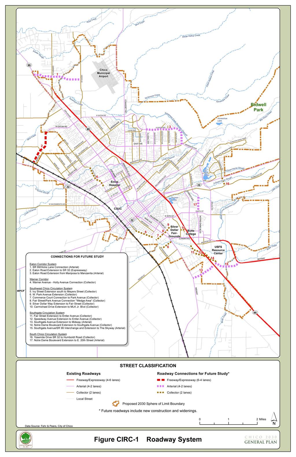
5 MULTIMODAL CIRCULATION SYSTEM This section of the Circulation Element describes how Chico s 2030 circulation system will accommodate all modes of travel and improve connectivity and mobility within and outside of the community. ROADWAYS The Roadway System Map (Figure CIRC-1) depicts roadways that support the Land Use Diagram, complete the street system, and reduce circuitous trips and vehicle miles traveled. Where appropriate, new connections that have been thoroughly studied will be located and designed as multimodal links between neighborhoods, employment centers, schools, and shopping areas. Goals and policies address system connectivity and complete streets, as well as flexibility in street design. Table CIRC-1 describes the different classes of streets, and Table CIRC-2 lists connections for future study, as shown on the Roadway System Map, Figure CIRC-1. The figure is not intended to show exact alignments of future roadways, but rather to show general connections that would be refined through future study and environmental review. Chico General Plan 4-5


6 TABLE CIRC-1 STREET CLASSIFICATIONS Street Classifications Freeways. Freeways serve regional, inter-city travel and should not become the optimum route for intra-city trips. Access is controlled, grade crossings are separated, and medians separate lanes moving in opposite directions. Typical free flow speeds exceed 55 miles per hour. Expressways. Expressways are designed to carry heavy traffic volumes at speeds of miles per hour. Expressways should serve longer distance intra-city travel as well as link the City with other nearby urban areas. Access is limited, crossings are generally signalized at grade, parking is prohibited, and a continuous median separates lanes in opposite directions. Arterials. The primary function of an arterial is to move large volumes of traffic between freeways and other arterials. Arterials generally provide four travel lanes, but may have fewer lanes. On street parking may be provided. Driveway access should be minimized, consistent with the primary function of arterials to move through traffic. Bike lanes, medians, park strips, sidewalks, and transit facilities are also accommodated within the right-of-way. Collectors. Collector streets provide a link between local streets and arterials. Collectors provide two travel lanes. On-street parking is generally permitted. Driveway access is allowed, but should be minimized. Bike lanes, park strips, sidewalks, and transit facilities are also typically accommodated within the right-of-way. Local Streets. The primary function of local streets is to provide direct access to adjacent properties. Local streets normally provide two travel lanes, landscaped park strips, sidewalks, and on-street parking. Bike lanes are not included because local streets have narrow street widths, carry low traffic volumes, and are considered to be bicycle-friendly. 4-6 Chico General Plan
7 TABLE CIRC-2 ROADWAY CONNECTIONS FOR FUTURE STUDY System/Roadway Classification Eaton Corridor System 1. SR 99/Hicks Lane Connection Arterial 2. Eaton Road Extension to SR 32 Expressway 3. Eaton Road Extension from Floral Avenue to Manzanita Arterial Warner Corridor 4. Warner Street - Holly Avenue Connection Collector Southwest Chico Circulation System 5. Ivy Street Extension south to Meyers Street Collector 6. W. Park Avenue Extension Collector 7. Commerce Court connection to Park Avenue Collector 8. Fair Street/Park Avenue connection through The Wedge Collector 9. Silver Dollar Way Extension to Fair Street Collector 10. Carmichael Drive Extension to MLK Jr. Blvd Collector Southgate Circulation System 11. Fair Street Extension to Entler Avenue Collector 12. Speedway Avenue Extension to Entler Avenue Collector 13. Southgate Avenue Extension to Midway Arterial 14. Notre Dame Boulevard Extension to Southgate Avenue Collector 15. Southgate Avenue/SR 99 interchange and Extension to The Skyway Arterial Southeast Chico Circulation System 16. Yosemite Drive - SR 32 to Humboldt Road Collector 17. Notre Dame Boulevard Extension to E. 20th Street Arterial Chico General Plan 4-7
8
9
10
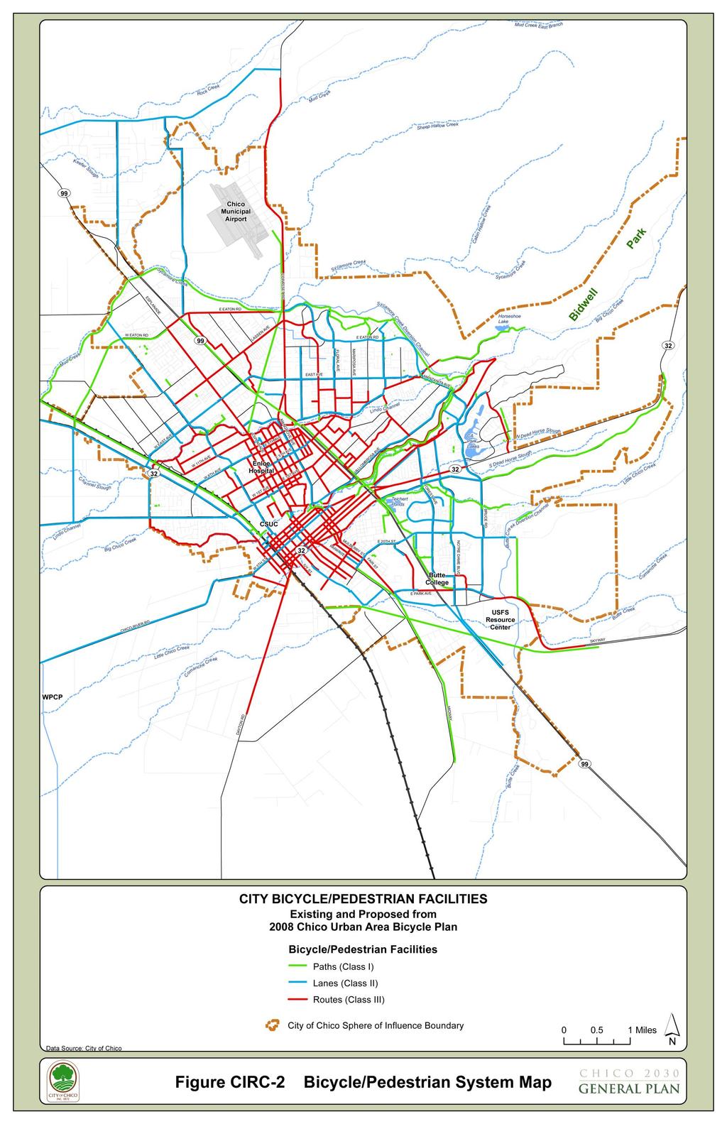
11 BIKEWAYS Chico prides itself as being a premier bicycle-friendly city. The Chico Urban Area Bicycle Plan (CUABPBike Plan), a comprehensive bicycle system plan for the City, was originally created in 1991 and is updated regularly. The existing and planned Bikeway/Pedestrian System Maps from the CUABP Bike Plan are shown in Figure CIRC-2. Future updates to the CUABP Bike Plan will include bicycle facilities in addition to those shown in Figure CIRC-2. Bicycle facilities within the City consist of the following: Class I Bicycle Paths provide a completely separated facility designed for the exclusive use of bicycles and pedestrians with minimal interruption by motorists. Class I bikeways typically have a minimum of 8 feet of pavement with 2-foot graded shoulders on either side. Class II Bicycle Lanes provide a restricted right-of-way designated for the exclusive or semi-exclusive use of bicycles with through travel by motor vehicles or pedestrians prohibited, but with vehicle parking and cross flows by pedestrians and motorists permitted. Class II bicycle lanes are typically a five-foot striped and signed lane. Class III Bicycle Routes provide designated areas where bicycles share the road with other modes of travel (such as vehicles). Class III routes are typically signed as such. The Circulation Element seeks to enhance bicycle travel by providing bicycle facilities on new roadways, enhancing connectivity within the existing bicycle system, and establishing policies to incorporate the consideration ofpromote bicycle transportation in a Mmultimodal environment. Level of Service (MMLOS) assessment. Chico General Plan 4-11

12 4-12 Chico General Plan 4. C I R C U L A T I O N
13
14


15 PEDESTRIAN WAYS The City of Chico s geographic location on the valley floor and its numerous creeks and drainage corridors provide opportunities for the continued development of a comprehensive pedestrian circulation system. The presence of Bidwell Park extending from Downtown Chico to the foothills serves as a well used east-west pedestrian corridor. Pedestrian facilities in the City are comprised primarily of pathways, sidewalks, trails, bridges, and pedestrian crossings. Most areas of the City have pathways or sidewalks, except for some older areas which developed under Butte County s jurisdiction. Most signalized intersections accommodate pedestrians with striped crosswalks and pedestrian signal heads. The City has made significant progress in its efforts to link the pedestrian circulation system and is exploring additional opportunities to develop shared bicycle and pedestrian facilities. Policies and actions in this element direct further efforts toward connecting pedestrian facilities Citywide. TRANSIT Public transportation services in Chico are provided by the regional B-Line system, managed and operated by the Butte County Association of Governments (BCAG). The B-Line provides a range of services from commuter routes throughout the County to local service routes in and around the community. Park-and-ride locations, such as the Caltrans facility located at SR 99 and Highway 32, promote and support the B-Line system. The Downtown transit hub advances the City s goal of convenient bus transit service for all residents. Comprehensive transit services are critical to the success of Chico s transportation system, as they serve the needs of various segments of the population, including students, workers, shoppers, the elderly, youth, and the disabled community. Public transit consists of the following services and facilities: Public Bus. The B-Line offers both fixed-route and demand-responsive services to City residents through local, commuter, and rural bus routes. There are currently 13 local fixed-routes within Chico. Figure CIRC-3 The following link identifies current B-Line routes and the Downtown transit center - In addition, CSU Chico and Butte College offer select routes to serve the specific needs of their students. Chico General Plan 4-15
16 4-16 Chico General Plan 4. C I R C U L A T I O N
17
18 Paratransit. B-Line Paratransit (Dial-A-Ride) is a complimentary paratransit service. Passengers with disabilities that prevent them from using the B-Line's fixed route bus system may apply to receive priority service on Dial-A-Ride. Other Commercial Transit. Other commercial transit service in Chico is provided by Greyhound and Amtrak which share a station near Downtown. Amtrak and Greyhound provide connecting service to Sacramento and other areas, depending on the carrier and the season. The Circulation Element advances the City s efforts to promote transit by requiring transit facilities on new roadways, implementing land use policies that support increased densities and intensities along transit corridors, and encouraging BCAG to implement a Central City Transit Route with frequent headways., and including transit as part of a Multimodal Level of Service assessment. VEHICLES MILES TRAVELLED REGULATIONS Formatted: Heading 2 On September 27, 2013, Governor Brown signed Senate Bill (SB) 743, which created a process to change the way that transportation impacts are analyzed under the California Environmental Quality Act (CEQA). Currently, environmental review of transportation impacts focuses on the delay that vehicles experience at intersections and on roadway segments. That delay is measured using a metric known as level of service, or LOS. Mitigation for increased delay generally involves increasing capacity (i.e., the width of a roadway or size of an intersection), which may increase auto use and emissions and discourage alternative forms of transportation. Under SB 743, the focus of transportation analysis has shifted from driver delay to reduction of greenhouse gas emissions, creation of multimodal networks, and promotion of a mix of land uses. LOS has been the standard by which local jurisdictions measure the transportation impacts of major developments and changes to roads. LOS is basically a measurement of how many cars can be pushed through an intersection in a given time. If a project reduced a road s LOS it was considered bad no matter how many other benefits the project may have created. When measuring transportation impacts of a project based solely on car delay, communities were often fighting against their own environmental goals. Using LOS, it is easier and cheaper to build projects in outlying areas where individual intersections show less delay resulting from new development. At the same time it is harder and more expensive to build in dense areas where there is already existing traffic, and where measured LOS impacts may require expensive mitigations or reduced project size but also where higher density can make transit, walking, and bicycling more viable transportation choices Chico General Plan


19 Under the new regulations, projects that are shown to decrease vehicle miles traveled for example, bike lanes or a grocery store that allows local residents to travel shorter distances to shop may be automatically considered to have a less than significant impact under CEQA. Formatted: Font color: Red Formatted: Font color: Red Formatted: Font color: Red Another change will come in how developments mitigate their transportation impacts. In many urban areas, under LOS analysis, the only way a development can lessen its impact is to widen a roadway. This can be particularly frustrating along major bus routes or anywhere bicyclists want to travel safely. Under the new rules, a development may instead mitigate transportation impacts by funding better transit, creating better access to transit, building better pedestrian facilities, or a host of other improvements that may improve travel choices. The new regulations are to be phased in over 2 years starting in The change in law does not require local governments to change the way they analyze traffic impacts for other purposes. The City will continue to use its LOS standards consistent with General Plan provisions, to promote safety and reduce congestion, and to support the impact fee program. MULTIMODAL LEVEL OF SERVICE AIRPORTS Chico has two general aviation airports: the Chico Municipal Airport (CMA), owned and operated by the City, and Ranchaero Airport, which is privately-owned but available for public use. The CMA is a modern, integrated air facility capable of accommodating air carriers as well as both general and commercial aviation planes. In December 2014, There is daily commercial service to San Francisco International Airport was discontinued., and t The City is actively working to secure commercial flight service. to additional cities. The CMA also serves as a primary regional base for fire-suppression aircraft. The Circulation Element and other elements of the General Plan seek to support the continued growth and successful operation of the airport by incorporating policies that address airport and land use compatibility, encourage the City s effort to attract additional passenger service options, and support the City s efforts to promote the airport as a major employment center. Chico General Plan 4-19

20 RAIL The City of Chico is served by the Union Pacific Railroad and Amtrak. The Circulation Element contains policies and actions which support the development of additional rail spur facilities to provide for enhanced goods movement opportunities and to minimize the impacts of passenger and rail freight operations on City residents and the City s circulation system Chico General Plan
21 GOALS, POLICIES, AND ACTIONS Goal CIRC-1: Provide a comprehensive multimodal circulation system that serves the build-out of the Land Use Diagram and provides for the safe and effective movement of people and goods. Goal CIRC-2: Enhance and maintain mobility with a complete streets network for all modes of travel. Goal CIRC-3: Expand and maintain a comprehensive, safe, and integrated bicycle system throughout the City that encourages bicycling. Goal CIRC-4: Design a safe, convenient, and integrated pedestrian system that promotes walking. Goal CIRC-5: Support a comprehensive and integrated transit system as an essential component of a multimodal circulation system. Goal CIRC-6 Plan for and promote a full range of aviation services and facilities that meet the present and future needs of residents and the business community. Goal CIRC-7 Increase rail services and improve rail freight movement facilities. Goal CIRC-8 Provide parking that supports the Citywide goals for economic development, livable neighborhoods, sustainability, and public safety. Goal CIRC-9 Reduce the use of single-occupant motor vehicles. Goal CIRC-1: Provide a comprehensive multimodal circulation system that serves the build-out of the Land Use Diagram and provides for the safe and effective movement of people and goods. OS Policy CIRC-1.1 (Transportation Improvements) Safely and efficiently accommodate traffic generated by development and redevelopment associated with build-out of the General Plan Land Use Diagram. Action CIRC (Road Network) Enhance existing roadways and intersections and develop the roadway system shown in Figure CIRC-1 over the life of the General Plan as needed to accommodate development. DT-5.1 Policy CIRC-1.2 (Project-level Circulation Improvements) Require new development to finance and construct internal and adjacent roadway circulation improvements as necessary to mitigate project impacts, including roadway, transit, pedestrian, and bicycle facilities. N-1.5 Chico General Plan 4-21
22 OS Policy CIRC-1.3 (Citywide Circulation Improvements) Collect the fair share cost of circulation improvements necessary to address cumulative transportation impacts, including those to state highways, local roadways, and transit, pedestrian and bicycle facilities, through the City s development impact fee program. Policy CIRC-1.4 (Level of Service Standards) Until a Multimodal Level of Service (MMLOS) methodology is adopted by the City, mmaintain LOS D or better for roadways and intersections at the peak PM period, except as specified below: LOS E is acceptable for City streets and intersections under the following circumstances: Downtown streets within the boundaries identified in Figure DT-1 of the Downtown Element. Arterials served by scheduled transit. Arterials not served by scheduled transit, if bicycle and pedestrian facilities are provided within or adjacent to the roadway. Utilize Caltrans LOS standards for Caltrans facilities. There are no LOS standards for private roads. Exceptions to the LOS standards above may be considered by the City Council where reducing the level of service would result in a clear public benefit. Such circumstances include, but are not limited to, the following: If improvements necessary to achieve the LOS standard results in impacts to a unique historical resource, a highly sensitive environmental area, requires infeasible right-of-way acquisition, or some other unusual physical constraint exists. If the intersection is located within a corridor that utilizes coordinated signal timing, in which case, the operation of the corridor as a whole should be considered. Policy CIRC-1.5 (Vehicle Miles Travelled Analysis) Consistent with State law, implement Vehicle Miles Travelled (VMT) assessments as part of the environmental review process under CEQA. Action CIRC (VMT CEQA Analysis) For projects that require a full traffic analysis as part of the CEQA review process, perform a VMT analysis consistent with the California Office of Planning and Research CEQA Guidelines. Formatted: Font: Bold Formatted: Font: Bold 4-22 Chico General Plan
23 Policy CIRC-1.5 (Multimodal Level of Service Program) Support implementation of a Multimodal Level of Service (MMLOS) assessment methodology. Policy CIRC-1.7 (Goods Movement) Provide clear routes for goods delivery. Action CIRC (Truck Routes) In consultation with Butte County, the Butte County Association of Governments, and Caltrans, continue to designate and provide signed truck routes through the City, and ensure that City roadways are maintained. ED Policy CIRC-1.8 (Regional Transportation Planning) Continue to participate in Butte County Association of Government s (BCAG) efforts to coordinate regional transportation planning with other jurisdictions, and continue to consult with Caltrans on transportation planning, operations, and funding to develop the City s circulation system. Action CIRC (BCAG Collaboration) Consult with BCAG on the development of the Regional Transportation Plan, and provide all information necessary for the Countywide traffic model to accurately reflect City development. Action CIRC (Sustainable Communities Strategy) Participate in BCAG s effort to prepare the regional Sustainable Communities Strategy. SUS-1.5 Action CIRC (Caltrans Highway Improvements) Consult with BCAG and Caltrans regarding the prioritization and timely construction of programmed freeway and interchange improvements on the state highway system. Policy CIRC-1.9 (Dedicated Funding Sources) Identify outside sources of funding and maximize the use of federal and other matching funding sources to provide ongoing maintenance, operation, and management of the City s circulation network. oss rence Goal CIRC-2: Enhance and maintain mobility with a complete streets network for all modes of travel. Policy CIRC-2.1 (Complete Streets) Develop an integrated, multimodal circulation system that accommodates transit, bicycles, pedestrians, and vehicles; provides opportunities to reduce air pollution and greenhouse gas emissions; and reinforces the role of the street as a public space that unites the City. Chico General Plan 4-23
24 Action CIRC (Complete Street Standards) With consideration of street classification and function, design new streets to accommodate all modes of travel, including transit, bicycles, pedestrians, vehicles and parking. Action CIRC (Retrofitting Existing Streets) Retrofit and upgrade existing streets, as funding allows, to include complete street amenities where appropriate, prioritizing improvements in locations that will improve the overall connectivity of the City s network of bicycle and pedestrian facilities or result in increased safety. Action CIRC (Multimodal Connections) Provide connections between and within existing and new neighborhoods for bicycles, pedestrians, and automobiles. Policy CIRC-2.2 (Circulation Connectivity and Efficiency) Provide greater street connectivity and efficiency for all transportation modes. SUS-1.6, CD-2.1.1, and DT-6.1 Action CIRC (Connectivity in Project Review) New development shall include the following internal circulation features: A grid or modified grid-based primary street system. Cul-de-sacs are discouraged, but may be approved in situations where difficult site planning issues, such as odd lot size, topography, or physical constraints exist or where their use results in a more efficient use of land, however in all cases the overall grid pattern of streets should be maintained; Traffic-calming measures, where appropriate; Roundabouts as alternative intersection controls, where appropriate; Bicycle and pedestrian connections to adjacent streets, trails, public-spaces, and bicycle paths; and Short block lengths consistent with City design standards. Action CIRC (Traffic Management) Perform routine, ongoing evaluation of the street traffic control system, with emphasis on traffic management, such as signal timing and coordination or the use of roundabouts, to optimize traffic flow along arterial corridors and reduce vehicle emissions. Action CIRC (Traffic-Calming Measures) Install appropriate trafficcalming devices, such as bulbing and reduced street widths, to discourage speeding and cut-through traffic on existing local streets. Action CIRC (Safe Routes to Schools) Work with the Chico Unified School District to identify, promote, and improve safe routes to schools. PPFS Chico General Plan
25 Policy CIRC-2.3 (Street Design Exceptions) Allow exceptions to the City s street design standards where circumstances warrant modifications. Action CIRC (Flexibility in Street Design) Update the Municipal Code to allow innovative and unique modifications to roadway standards under the following circumstances: Extraordinary construction requirements due to terrain, roadside development, or unusual right-of-way needs. Significant environmental constraints. As specified by Community Design policies regarding Chico s scenic roadways and foothill locations. Goal CIRC-3: Expand and maintain a comprehensive, safe, and integrated bicycle system throughout the City that encourages bicycling. CD OS Policy CIRC-3.1 (Bikeway Master Plan) Implement and update the Chico s Urban Area Bicycle Master Plan. (CUABP) consistent with the goals and policies of the General Plan. Action CIRC (Add Bicycle Facilities) Incorporate bicycle facilities identified in the CUABP Bicycle Master Plan into public road construction projects and private development projects. Action CIRC (Bikeway Connections) Increase connectivity of existing bike facilities to enhance bikeway network completeness. Action CIRC (Bicycle ings) Identify and pursue funding to construct crossings at creeks, railroads, and roadways consistent with the Bicycle Master PlanChico Urban Area Bicycle Plan to improve bicycle and pedestrian connectivity. Action CIRC (Regional Bicycle Trail Coordination) Consult with Butte County, Butte County Association of Governments, and other agencies regarding implementation of a regional bikeway system. Action CIRC (Bikeway Map) Promote bicycle use by providing an updated map of Chico s bikeways, as necessary, to bicycle stores, CSU Chico, and other key meeting places for bicyclists. Policy CIRC-3.2 (CSU Chico Bicycle Access) Continue to encourage CSU Chico to reintroduce opportunities for safe bicycle access into, around and through the main campus area. Chico General Plan 4-25
26 CD Policy CIRC-3.3 (New Development and Bikeway Connections) Ensure that new residential and non-residential development projects provide connections to the nearest bikeways. Action CIRC (Bikeway Requirements) Require pedestrian and bicycle connections to the Citywide bikeway system every 500 feet, where feasible, as part of project approval and as identified in the Bicycle Master Plan.Chico Urban Area Bicycle Plan. Policy CIRC-3.4 (Bicycle Safety) Improve safety conditions, efficiency, and comfort for bicyclists through traffic engineering, maintenance and law enforcement. Action CIRC (Construction and Maintenance) Continue to ensure that all new and improved streets have bicycle-safe drainage grates and are free of hazards such as uneven pavement and gravel. Maintain a program for the sweeping and repair of bikeways. Action CIRC (Signage, Markings, and Lighting) Continue to provide signage and markings to warn vehicular traffic of the existence of merging or crossing bicycle traffic where bikeways make transitions into or across roadways. Delineate and sign bikeways in accordance with Caltrans standards and install, where feasible, lighting for safety and comfort. Action CIRC (Bike Safety in Schools) Consult with the Chico Unified School District, CSU Chico, and Butte College regarding development of an educational campaign promoting bicycle safety and Safe Routes to School programs. Action CIRC (Bicycle Detection at Traffic Signals) Continue to install bicycle detectors at high volume bicycle/automobile intersections that have actuated signals. Policy CIRC-3.5 (Funding Bicycle Improvements) - Consider bikeway improvements when establishing funding priorities for the City and adopting the Capital Improvement Program. Action CIRC (Other Funding Sources) Continue to pursue funding sources, including state and federal grants, for new bicycle facilities. Policy CIRC-3.6 (Bicycle Parking) Provide safe and secure bicycle parking and support facilities Chico General Plan
27 Action CIRC (Bicycle Parking and Facilities) Update Maintain standards in the Municipal Code requirements for bicycle parking, and include where appropriate, requirements for bicycle-support facilities., such as personalockers and showers. Goal CIRC-4: Design a safe, convenient, and integrated pedestrian system that promotes walking. OS Policy CIRC-4.1 (Pedestrian Master Planning) Continue to integrate and highlight pedestrian access and dual use bicycle and pedestrian pathways in the Bicycle Master PlanChico Urban Area Bicycle Plan. Policy CIRC-4.2 (Continuous Network) Provide a pedestrian network in existing and new neighborhoods that facilitates convenient and continuous pedestrian travel free from major impediments and obstacles. LU-3.3.1, LU , and CD-2.1 Action CIRC (Housing or Destination Connections) Amend the Municipal Code to require new subdivisions and large-scale developments to include safe pedestrian walkways that provide direct links between streets and major destinations such as transit stops, schools, parks, shopping centers, and jobs. Action CIRC (Neighborhood Planning of Street Improvements) Continue to use the neighborhood planning processuse neighborhood plans to identify neighborhood priorities for the improvement of existing streets, including pedestrian facilities. Policy CIRC-4.3 (Pedestrian-Friendly Streets) Ensure that streets in areas with high levels of pedestrian activity, such as near schools, employment centers, residential areas, and mixed-use areas, support safe pedestrian travel by providing elements such as detached sidewalks, bulb-outs, on-street parking, enhanced pedestrian crossings, and medians. LU and LU CD 3.2 and DT-3.1 oss ences Action CIRC (Safe Pedestrian ings) As funding allows, improve pedestrian safety at intersections and other crossing locations by providing safe, well-marked pedestrian crossings, bulb-outs, on-street parking, audible warnings, or median refuges that reduce crossing widths. Action CIRC (Expand Sidewalk Infrastructure) As funding allows, continue installation of sidewalk and pedestrian-related infrastructure in areas not currently served. oss rence Goal CIRC-5: Support a comprehensive and integrated transit system as an essential component of a multimodal circulation system. Chico General Plan 4-27
28 Policy CIRC-5.1 (Transit Planning) Consult with and encourage the Butte County Association of Governments (BCAG) to implement a comprehensive transit system that serves Chico s current and future needs. Action CIRC (Transit Master Plan) Participate in BCAG s transit master planning efforts to help ensure that transit routes coincide with Chico s major destinations for employment and shopping, concentrations of housing, key institutions, and other land uses likely to supply riders for public transit. Action CIRC (Intercity Bus Service) In consultation with BCAG, Greyhound, and Amtrak, monitor demand for intercity bus transit service. DT Action CIRC (Transit Center) Maintain the Downtown Transit Center as the key hub for intra-city public transportation. Action CIRC (Enhanced B-Line) In consultation with BCAG, pursue funding sources and partnerships to support an enhanced B-Line with more frequent headways. Policy CIRC-5.2 (Central City Transit Route) Encourage the maintenance and expansion of a central city transit route that is frequently served by easilyrecognizable transit vehicles connecting heavily visited City locations, such as CSU Chico, Enloe Medical Center, shopping, entertainment areas, employment centers and Downtown. Action CIRC (Transit Oriented Development) Support new development and redevelopment within the Central City and Corridor Opportunity Sites to support ridership. Action CIRC (Central City Route Marketing) Bolster community support, awareness, and ridership of a central city transit route by encouraging BCAG to solicit public input on the naming and exterior design of its transit vehicles. Policy CIRC-5.3 (Transit Connectivity in Projects) Ensure that new development supports public transit. Action CIRC (Roadway Transit Facilities) When planning or retrofitting roadways, consult with BCAG regarding the inclusion of transit stops, shelters, bus turnouts, and other transit improvements. Action CIRC (Transit Improvements for New Development) During project review, consult with BCAG to determine appropriate requirements for the 4-28 Chico General Plan
29 installation of stops and streetscape improvements, if needed to accommodate transit. Goal CIRC-6: Plan for and promote a full range of aviation services and facilities that meet the present and future needs of residents and the business community. Policy CIRC-6.1 (Airport Services) Improve and maintain Chico Municipal Airport for commercial, general, and special aviation needs. Action CIRC (Land Use in Airport Vicinity) Ensure that development in the area adjacent to the airport is compatible with airport operations. ED-1.7 S-6.2 Policy CIRC-6.2 (Air Transportation) Increase the availability of passenger air transportation in Chico. Action CIRC (Routing Alternatives) Continue to ppursue additional passenger flights to and from Chico with varied origins and destinations. Goal CIRC-7: Increase rail services and improve rail freight movement facilities. Policy CIRC-7.1 (Rail Services) Consult with other agencies and private entities to identify ways to maintain, improve, and expand rail services to safely meet existing and future needs of residents and businesses. Action CIRC (Passenger Rail Service) Investigate opportunities to partner with other agencies to explore the feasibility of expanding passenger rail service to Chico as part of a statewide system. oss rence.1 and oss rence.1.3 Action CIRC (Existing Railroad ings) Continue ongoing partnerships to improve the condition and safety of railroad crossings by upgrading surface conditions and providing adequate signs and signals. Action CIRC (New Grade-Separated ings) Explore the feasibility of constructing new grade-separated crossings based on state criteria and funding availability at the following locations: State Route 32 at 8 th and 9 th streets (included in the Regional Transportation Plan); West 8th Avenue; West East Avenue; Chico General Plan 4-29
30 West Second Street; and State Route 32 at Eaton Rd. Goal CIRC-8: Provide parking that supports the Citywide goals for economic development, livable neighborhoods, sustainability, and public safety. Policy CIRC-8.1 (Appropriate Parking) Ensure that parking is provided in appropriate locations and amounts. LU Action CIRC (Parking Standards) Amend Maintain the Municipal Code to establish parking standards that support trip reduction goals by: Allowing parking reductions for projects that implement trip reduction methods (such as vehicle loan program and transit passes), for mixed-use developments, and for shared parking; and Requiring new office projects with more than 25 employees to provide preferential on-site parking for carpools. Action CIRC (Parking Requirements) Amend themaintain standards in the Municipal Code to that include minimum and maximum parking requirements that reduce surface parking area and ensure areas are not over-parked based on development intensity, proximity to transit stations, and availability of nearby onstreet parking and parking facilities. DT DT-3.6 and DT-7.1 Policy CIRC-8.2 (Parking Improvements) Ensure that new parking facilities and renovations are designed to be safe, efficient, and pedestrian-friendly. Action CIRC (Parking Facility Design) Require that parking facilities are designed with convenient connections to adjoining businesses and the public right-of-way and, where possible, shared access between adjacent development. This may include reducing barriers between existing parking lots to facilitate shared parking and providing pedestrian connections between adjacent developments. Action CIRC (Public Parking Facilities) When designing new public parking facilities, incorporate preferred parking for renewable energy vehicles and assess the need for electric vehicle charging stations. Policy CIRC-8.3 (Identify Parking Deficiencies and Conflicts) Monitor parking supply and utilization to identify deficiencies or conflicts as they develop, particularly for public parking areas in Downtown. DT and DT Goal CIRC-9: Reduce the use of single-occupant motor vehicles Chico General Plan
31 Policy CIRC-9.1 (Reduce Peak-Hour Trips) Strive to reduce single occupant vehicle trips through the use of travel demand management strategies. Action CIRC (City Travel Demand Management) Develop and implement a City of Chico Travel Demand Management Plan that provides incentives for City employees to commute in modes other than single-occupant vehicles. SUS-6.1 SUS-3.4 Action CIRC (Existing Employer Trip Reduction Programs) Encourage employers to provide transit subsidies, bicycle facilities, alternative work schedules, ridesharing, telecommuting and work-at-home programs, and preferential parking for carpools/vanpools. Action CIRC (New Employer Trip Reduction Programs) As a condition of project approval, require new non-residential projects that will employ more than 100 people to submit a Travel Demand Management Plan that identifies strategies, such as those listed in Action CIRC-9.1.2, to reduce singleoccupancy vehicle trips. Policy CIRC-9.2 (Off-Peak Deliveries) Encourage business owners to schedule deliveries during off-peak traffic periods. Policy CIRC-9.3 (Emphasize Trip Reduction) Emphasize automotive trip reduction in the design, review, and approval of public and private development. DT CD Chico General Plan 4-31
Solana Beach Comprehensive Active Transportation Strategy (CATS)
") Solana Beach Comprehensive Active Transportation Strategy (CATS) 3.0 Goals & Policies The Solana Beach CATS goals and objectives outlined below were largely drawn from the Solana Beach Circulation Element
Solana Beach Comprehensive Active Transportation Strategy (CATS) 3.0 Goals & Policies The Solana Beach CATS goals and objectives outlined below were largely drawn from the Solana Beach Circulation Element
Circulation in Elk Grove includes: Motor vehicles, including cars and trucks
 Circulation, as it is used in this General Plan, refers to the many ways people and goods move from place to place in Elk Grove and the region. Circulation in Elk Grove includes: Motor vehicles, including
CITY OF COCOA BEACH 2025 COMPREHENSIVE PLAN. Section VIII Mobility Element Goals, Objectives, and Policies
 CITY OF COCOA BEACH 2025 COMPREHENSIVE PLAN Section VIII Mobility Element Goals, Objectives, and Policies Adopted August 6, 2015 by Ordinance No. 1591 VIII MOBILITY ELEMENT Table of Contents Page Number
Proposed. City of Grand Junction Complete Streets Policy. Exhibit 10
 Proposed City of Grand Junction Complete Streets Policy Exhibit 10 1 City of Grand Junction Complete Streets Policy Vision: The Complete Streets Vision is to develop a safe, efficient, and reliable travel
Bicycle Master Plan Goals, Strategies, and Policies
 Bicycle Master Plan Goals, Strategies, and Policies Mobilizing 5 This chapter outlines the overarching goals, action statements, and action items Long Beach will take in order to achieve its vision of
Corpus Christi Metropolitan Transportation Plan Fiscal Year Introduction:
 Introduction: The Safe, Accountable, Flexible, Efficient Transportation Equity Act: A Legacy for Users (SAFETEA-LU) has continued the efforts started through the Intermodal Surface Transportation Efficiency
Chapter 7. Transportation. Transportation Road Network Plan Transit Cyclists Pedestrians Multi-Use and Equestrian Trails
 Chapter 7 Transportation Transportation Road Network Plan Transit Cyclists Pedestrians Multi-Use and Equestrian Trails 7.1 TRANSPORTATION BACKGROUND The District of Maple Ridge faces a number of unique
Chapter 2. Bellingham Bicycle Master Plan Chapter 2: Policies and Actions
 Chapter 2 Bellingham Bicycle Master Plan Chapter 2: Policies and Actions Chapter 2: Policies and Actions The Bicycle Master Plan provides a road map for making bicycling in Bellingham a viable transportation
ACTIVE TRANSPORTATION
 ACTIVE TRANSPORTATION Mobility 2040 Supported Goals Improve the availability of transportation options for people and goods. Support travel efficiency measures and system enhancements targeted at congestion
CONNECTING PEOPLE TO PLACES
 CONNECTING PEOPLE TO PLACES 82 EAST BENCH MASTER PLAN 07 Introduction The East Bench transportation system is a collection of slow moving, treelined residential streets and major arteries that are the
Living Streets Policy
 Living Streets Policy Introduction Living streets balance the needs of motorists, bicyclists, pedestrians and transit riders in ways that promote safety and convenience, enhance community identity, create
Transportation Master Plan Advisory Task Force
 Transportation Master Plan Advisory Task Force Network Alternatives & Phasing Strategy February 2016 BACKGROUND Table of Contents BACKGROUND Purpose & Introduction 2 Linking the TMP to Key Council Approved
CITY OF BLOOMINGTON COMPLETE STREETS POLICY
 CITY OF BLOOMINGTON COMPLETE STREETS POLICY POLICY OBJECTIVE: The City of Bloomington will enhance safety, mobility, accessibility and convenience for transportation network users of all ages and abilities,
West Dimond Blvd Upgrade Jodhpur Street to Sand Lake Road
 West Dimond Blvd Jodhpur St to Sand Lake CSS Transportation Project Summary Municipality of Anchorage Project # 05 005 Project Manager: John Smith, P.E. (MOA PM&E) Project Administrator: Julie Makela,
REGIONAL BICYCLE AND PEDESTRIAN DESIGN GUIDELINES
 REGIONAL BICYCLE AND PEDESTRIAN DESIGN GUIDELINES November 16, 2011 Deb Humphreys North Central Texas Council of Governments Bicycle and Pedestrian Advisory Committee Snapshot of the Guide 1. Introduction
Classification Criteria
 SCHEDULE D TO RECOMMENDED OFFICIAL PLAN AMENDMENT NO. 40 SCHEDULE C-4 Road Criteria Criteria Traffic Service Objective Land Service/Access Typical Daily Traffic Volume Flow characteristics Travel Speed
Exhibit 1 PLANNING COMMISSION AGENDA ITEM
 Exhibit 1 PLANNING COMMISSION AGENDA ITEM Project Name: Grand Junction Circulation Plan Grand Junction Complete Streets Policy Applicant: City of Grand Junction Representative: David Thornton Address:
APPENDIX A: Complete Streets Checklist DRAFT NOVEMBER 2016
 APPENDIX A: Complete Streets Checklist DRAFT NOVEMBER 2016 Complete Streets Checklist MetroPlan Orlando s Complete Streets Checklist is an internal planning tool for staff to further implementation of
NM-POLICY 1: Improve service levels, participation, and options for non-motorized transportation modes throughout the County.
 Transportation PRINCE WILLIAM COUNTY 2008 COMPREHENSIVE PLAN NON-MOTORIZED PLAN CONTENTS Goals, Policies, and Action Strategies Table 4 (Bike Facility Classifications and Descriptions) Table 5 (Bike Facility
TRANSPORTATION TRAINING TOPICS. April 6, 2010
 TRANSPORTATION TRAINING TOPICS April 6, 2010 Roles of Transportation Providers Context and Policy Makers Division of Transportation and Traffic Other City Operations Other Transportation Operators CMA
TRANSIT & NON-MOTORIZED PLAN DRAFT FINAL REPORT Butte County Association of Governments
 1 INTRODUCTION Maintaining a high quality of life is the essence of this plan for transit and non-motorized transportation in Butte County. Curbing greenhouse gas emissions (GHG) by reducing congestion,
General Plan Circulation Element Update Scoping Meeting April 16, 2014 Santa Ana Senior Center, 424 W. 3rd Street, Santa Ana, CA 92701
 General Plan Circulation Element Update Scoping Meeting April 16, 2014 Santa Ana Senior Center, 424 W. 3rd Street, Santa Ana, CA 92701 Meeting Agenda 1. Purpose of Scoping Meeting 2. Project Overview 3.
City of Novi Non-Motorized Master Plan 2011 Executive Summary
 City of Novi Non-Motorized Master Plan 2011 Executive Summary Prepared by: February 28, 2011 Why Plan? Encouraging healthy, active lifestyles through pathway and sidewalk connectivity has been a focus
This chapter describes the proposed circulation system and transportation alternatives associated with
 5.0 Circulation 5.1 OVERVIEW This chapter describes the proposed circulation system and transportation alternatives associated with West Landing, and summarize the information contained in the Existing
Clackamas County Comprehensive Plan
 ROADWAYS The County s road system permits the movement of goods and people between communities and regions, using any of a variety of modes of travel. Roads provide access to virtually all property. They
ACTIVE TRANSPORTATION/NONMOTORIZED TRANSPORTATION
 ACTIVE TRANSPORTATION/NONMOTORIZED TRANSPORTATION BACKGROUND Active transportation, also known as nonmotorized transportation, is increasingly recognized as an important consideration when planning and
APPROVE A RESOLUTION ADOPTING A COMPLETE STREETS POLICY
 STAFF REPORT MEETING DATE: September 13, 2016 TO: FROM: City Council Bob Brown, Community Development Director Russ Thompson, Public Works Director Patrick Filipelli, Management Analyst 922 Machin Avenue
Chapter 5. Complete Streets and Walkable Communities.
 Chapter 5. Complete Streets and Walkable Communities. 5.1 Description of Complete Streets. Cities throughout the world, and specifically the United States, are coming to embrace a new transportation and
MCTC 2018 RTP SCS and Madera County RIFP Multi-Modal Project Eval Criteria GV13.xlsx
 MCTC 8 RTP SCS and Madera County RIFP Multi-Modal Project Eval Criteria GV.xlsx Madera County Transportation Commission Regional Transportation Plan / Sustainable Communities Strategy Multi-Modal Project
Omaha s Complete Streets Policy
 Omaha s Complete Streets Policy (Adopted August 2015) VISION To create great places and enhance our quality of life, the City of Omaha will provide safe, accessible streets for all users. Complete Streets
Berkeley Strategic Transportation Plan A-76
 Berkeley Strategic Transportation Plan A-76 Appendices 1. A Team Effort 2. Where We ve Been A-11 Berkeley Strategic Transportation Plan Alameda County Transportation Plan Alameda County will be served
Perryville TOD and Greenway Plan
 Perryville TOD and Greenway Plan Greenway Glossary Pathway: A bicycle and pedestrian path separated from motorized vehicular traffic by an open space, barrier or curb. Multi-use paths may be within the
5/31/2016 VIA . Arwen Wacht City of Sacramento Community Development Department 300 Richards Blvd., 3 rd Floor Sacramento, CA 95811
 5/31/2016 VIA EMAIL Arwen Wacht City of Sacramento Community Development Department 300 Richards Blvd., 3 rd Floor Sacramento, CA 95811 RE: El Pollo Loco (P16-028) Dear Ms. Wacht: WALKSacramento has reviewed
5. RUNNINGWAY GUIDELINES
 5. RUNNINGWAY GUIDELINES These guidelines should be considered collectively when making runningway decisions. A runningway is the linear component of the transit system that forms the right-of-way reserved
5 CIRCULATION AND STREET DESIGN
 5 CIRCULATION AND STREET DESIGN This chapter describes circulation and streetscape improvements proposed for the Northwest Chico Specific Plan Area. It includes detailed design specifications for existing
o n - m o t o r i z e d transportation is an overlooked element that can greatly enhance the overall quality of life for the community s residents.
 N o n - m o t o r i z e d transportation is an overlooked element that can greatly enhance the overall quality of life for the community s residents. 84 Transportation CHAPTER 11 INTRODUCTION Transportation
Chapter 5 Future Transportation
 Chapter 5 Future Transportation The Future Land Use Plan identifies the desired land use designations. The land uses desired for Crozet depend, in large part, on the success of the transportation system,
Active Transportation Facility Glossary
 Active Transportation Facility Glossary This document defines different active transportation facilities and suggests appropriate corridor types. Click on a facility type to jump to its definition. Bike
SECTION 1 - TRAFFIC PLANNING
 SECTION 1 - TRAFFIC PLANNING 1.1 TRAFFIC OPERATIONS 1.1.1 Roadway Functional Classification The Multnomah County Comprehensive Framework Plan s Policy 34: Trafficways and the Functional Classification
RESOLUTION NO ?? A RESOLUTION OF THE CITY OF NEPTUNE BEACH ADOPTING A COMPLETE STREETS POLICY
 RESOLUTION NO. 2018-?? A RESOLUTION OF THE CITY OF NEPTUNE BEACH ADOPTING A COMPLETE STREETS POLICY WHEREAS, safe, convenient, and accessible transportation for all users is a priority of the City of Neptune
Chapter 9: Pedestrians and Bicyclists
 Chapter 9: Pedestrians and Bicyclists Walking and bicycling are essential modes of transportation. These modes allow people to travel without contributing to congestion and air pollution, to access other
Multimodal Through Corridors and Placemaking Corridors
 68 Multimodal Through Corridors and Placemaking Corridors Corridors have different functions in a region. Some corridors are used to get smoothly and rapidly through a region or to get quickly to major
Develop a Multi-Modal Transportation Strategy (Theme 6)
") DEVELOP A MULTI-MODAL TRANSPORTATION STRATEGY (THEME 6) WHY IS THIS THEME ADDRESSED? Develop a Multi-Modal Transportation Strategy (Theme 6) Statement of Ideal Reduce resident and visitor reliance on single
DEVELOP A MULTI-MODAL TRANSPORTATION STRATEGY (THEME 6) WHY IS THIS THEME ADDRESSED? Develop a Multi-Modal Transportation Strategy (Theme 6) Statement of Ideal Reduce resident and visitor reliance on single
2025 Comprehensive Plan for the City of Temple Terrace Florida. Mobility Element. Adopted by City Council June 30, 2009
 2025 Comprehensive Plan for the City of Temple Terrace Florida Mobility Element Adopted by City Council June 30, 2009 Effective Date September 22, 2009 GOAL 2: To protect and promote the quality of life
New Measure A Expenditure Categories DEFINITIONS OF ELIGIBLE EXPENDITURES Adopted March 8, 2007
 New Measure A Expenditure Categories DEFINITIONS OF ELIGIBLE EXPENDITURES Adopted March 8, 2007 City Street and County Road Maintenance Program The preservation and keeping of public street and road rights-of-way
SANTA CLARA COUNTYWIDE BICYCLE PLAN August 2008
 SANTA CLARA COUNTYWIDE BICYCLE PLAN August 2008 To assist VTA and Member Agencies in the planning, development and programming of bicycle improvements in Santa Clara County. Vision Statement To establish,
Regional Transportation Needs Within Southeastern Wisconsin
 Regional Transportation Needs Within Southeastern Wisconsin #118274 May 24, 2006 1 Introduction The Southeastern Wisconsin Regional Planning Commission (SEWRPC) is the official areawide planning agency
AMATS Complete Streets Policy
 AMATS Complete Streets Policy Table of Contents: Section 1. Definition of Complete Streets Section 2. Principles of Complete Streets Section 3. Complete Streets Policy Section 4. Consistency Section 5.
WELCOME TO OPEN HOUSE # 1 June 14, 2017
 Langstaff Road Weston Road to Highway 7 Class Environmental Assessment Study WELCOME TO OPEN HOUSE # 1 June 14, 2017 Please sign in and join our mailing list Purpose of Open House #1 & Study Area York
CHAPTER 7.0 IMPLEMENTATION
 CHAPTER 7.0 IMPLEMENTATION Achieving the vision of the Better Streets Plan will rely on the ability to effectively fund, build and maintain improvements, and to sustain improvements over time. CHAPTER
Executive Summary Route 30 Corridor Master Plan
 Route Corridor Master Plan Project Overview The Route Corridor Master Plan is a coordinated multimodal transportation and land use plan for the entire stretch of Route through East Whiteland Township,
City of Wayzata Comprehensive Plan 2030 Transportation Chapter: Appendix A
 A1. Functional Classification Table A-1 illustrates the Metropolitan Council s detailed criteria established for the functional classification of roadways within the Twin Cities Metropolitan Area. Table
GOAL 2A: ESTABLISH AND MAINTAIN A SAFE, CONVENIENT, AND EFFICIENT MULTI-MODAL TRANSPORTATION SYSTEM TO MOVE PEOPLE AND GOODS THROUGHOUT THE CITY.
 2. TRANSPORTATION ELEMENT The purpose of this element is to assist in establishing an adequate transportation system within the City and to plan for future motorized and non-motorized traffic circulation
EXECUTIVE SUMMARY. Vision
 Vision Walking and bicycling in Salt Lake City will be safe, convenient, comfortable, and viable transportation options that connect people to places, foster recreational and economic development opportunities,
4. ENVIRONMENTAL IMPACT ANALYSIS 9. TRANSPORTATION AND TRAFFIC
 4. ENVIRONMENTAL IMPACT ANALYSIS 9. TRANSPORTATION AND TRAFFIC 4.9.1 INTRODUCTION The following section addresses the Proposed Project s impact on transportation and traffic based on the Traffic Study
6-1 ELK GROVE GENERAL PLAN MOBILITY
 6-1 ELK GROVE GENERAL PLAN CHAPTER 6: ELK GROVE GENERAL PLAN 6-2 OVERVIEW Mobility (synonymous with the term circulation) is the beating heart and circulatory system of a city, enabling the movement of
Welcome. Background. Goals. Vision
 Welcome The formal Public Information Centre (PIC) for the Transportation Master Plan How We GO will be held in early 2017. At that time we will present the recommended transportation system for Niagara
Madison Urban Area and Dane County. Bicycle Transportation Plan Summary. September Introduction. Bicycle Plan Scope and Planning Process
 Bicycle Transportation Plan Summary Madison Urban Area and Dane County Introduction September 2000 Bicycling is an important mode of transportation in the Madison urban area and countywide that is available
Roadways. Roadways III.
 Introduction 97 Roadway Design Principles 98 Safe Speeds 99 Optimizing of Street Space 00 Minimum Lane Widths in the City of Boston 02 Design Features that Reduce Operating Speeds 05 Travel Lanes Transit
Basalt Creek Transportation Refinement Plan Recommendations
 Basalt Creek Transportation Refinement Plan Recommendations Introduction The Basalt Creek transportation planning effort analyzed future transportation conditions and evaluated alternative strategies for
12/4/2016 VIA . RE: Grocery Outlet Del Paso (DR16-328)
") 12/4/2016 VIA EMAIL Ethan Meltzer, Assistant Planner City of Sacramento Community Development Department 300 Richards Blvd, 3 rd Floor Sacramento, CA 95811 RE: Grocery Outlet Del Paso (DR16-328) Dear Mr.
12/4/2016 VIA EMAIL Ethan Meltzer, Assistant Planner City of Sacramento Community Development Department 300 Richards Blvd, 3 rd Floor Sacramento, CA 95811 RE: Grocery Outlet Del Paso (DR16-328) Dear Mr.
ROADSOADS CONGESTION HAMPTON SYSTEMYSTEM MANAGEMENT. Part II Roadway Congestion Analysis Mitigation Strategies and Evaluation
 HAMPTON ROADSOADS CONGESTION MANAGEMENT SYSTEMYSTEM Part II Roadway Congestion Analysis Mitigation Strategies and Evaluation Presented by: Dwight Farmer, PE Deputy Executive Director, Transportation April
T1-A - Service Reduction (Re-sizing)
") Key T1-A Choice A Key T1-B Choice B Key T1-C Choice C Key T1-D Choice D Key T1-E Choice E Key T1-F Choice F Key Choice G T2 T1-A - Service Reduction (Re-sizing) Description This key choice would represent
Key T1-A Choice A Key T1-B Choice B Key T1-C Choice C Key T1-D Choice D Key T1-E Choice E Key T1-F Choice F Key Choice G T2 T1-A - Service Reduction (Re-sizing) Description This key choice would represent
Appendix 3 Roadway and Bike/Ped Design Standards
 Appendix 3 Roadway and Bike/Ped Design Standards OTO Transportation Plan 2040 4/20/2017 Page A3-1 Adopted Standards The adopted OTO Design Standards and Major Thoroughfare Plan are contained herein.
2. TRANSPORTATION ELEMENT.
 2. TRANSPORTATION ELEMENT. The purpose of this element is to assist in establishing an adequate transportation system within the City and to plan for future motorized and non-motorized traffic circulation
NJDOT Complete Streets Checklist
 Background The New Jersey Department of Transportation s Complete Streets Policy promotes a comprehensive, integrated, connected multi-modal network by providing connections to bicycling and walking trip
5/7/2013 VIA . RE: University Village Safeway Expansion (P13-019)
") 5/7/2013 VIA EMAIL David Hung, Associate Planner Community Development Department, Current Planning Division City of Sacramento 300 Richards Boulevard, 3 rd Floor Sacramento, CA 95811 RE: University Village
5/7/2013 VIA EMAIL David Hung, Associate Planner Community Development Department, Current Planning Division City of Sacramento 300 Richards Boulevard, 3 rd Floor Sacramento, CA 95811 RE: University Village
12 RECOMMENDATIONS Road Improvements. Short Term (generally the next five years)
") 12 RECOMMENDATIONS Recommendations are based on the technical analysis of existing and future road and active transportation conditions, the results of the review of existing City policies and public feedback.
12 RECOMMENDATIONS Recommendations are based on the technical analysis of existing and future road and active transportation conditions, the results of the review of existing City policies and public feedback.
Chapter 6 Transportation Plan
 Chapter 6 Transportation Plan Transportation Plan Introduction Chapter 6 Transportation Plan Transportation Plan Introduction This chapter describes the components of Arvada s transportation system, comprised
4 MOBILITY PLAN. Mobility Plan Objectives. Mobility Context. 1. Integrate with Local and Regional Transit Improvements
 Harbor Mixed Use CHAPTER Transit Corridor 4: Mobility Plan 4 MOBILITY PLAN Mobility Plan Objectives The Harbor Corridor Plan seeks to expand and improve the ways that people move along and through the
City Council Agenda Item #6-A CITY OF ALAMEDA Memorandum. To: Honorable Mayor and Members of the City Council. John A. Russo City Manager
 CITY OF ALAMEDA Memorandum To: From: Honorable Mayor and Members of the City Council John A. Russo City Manager Date: January 14, 2013 Re: Adopt a Resolution Approving a Complete Streets Policy, in Accordance
2040 RTP. Chapter 6: Investments in our Transportation Future
 2040 RTP Chapter 6: Investments in our Transportation Future This chapter describes the transportation investments proposed for the San Benito region that support the goals and objectives of the Regional
Purpose and Need. Chapter Introduction. 2.2 Project Purpose and Need Project Purpose Project Need
 Chapter 2 Purpose and Need 2.1 Introduction The El Camino Real Bus Rapid Transit (BRT) Project (Project) would make transit and other transportation improvements along a 17.6-mile segment of the El Camino
Double the amount of bicycle ridership while at the same time reducing the number of bicycle crashes by one-third.
 CHAPTER 6 Recommended Policies and Action Items To achieve the goals stated in Chapter 1 and guide implementation of the Bicycle Plan, policies and action items have been identified. They are presented
Active Transportation Infrastructure Investment A Business Case
 Active Transportation Infrastructure Investment A Business Case In 2016, the Real Estate Foundation awarded the Capital Regional District a $50,000 grant for Shifting Gears: Land Use Change through Active
RESOLUTION NO A RESOLUTION OF THE CITY COUNCIL OF THE CITY OF MENLO PARK ADOPTING A COMPLETE STREETS POLICY
 RESOLUTION NO. 6123 A RESOLUTION OF THE CITY COUNCIL OF THE CITY OF MENLO PARK ADOPTING A COMPLETE STREETS POLICY WHEREAS, the term Complete Streets describes a comprehensive, integrated transportation
4 TRANSPORTATION ELEMENT
 4 TRANSPORTATION ELEMENT Chico strives to create a balanced transportation system that serves bicyclists and pedestrians as well as motor vehicles. The original grid layout provided street connections
Goal 3: Foster an environment of partnerships and collaboration to connect our communities and regions to one another.
 Non-Motorized Transportation Plan (NMTP) Draft Vision, Goal and,, Tri-County Regional Planning Commission (TCRPC) Purpose The purpose of the Tri-County Regional Planning Commission (TCRPC) Non-Motorized
Agenda. Overview PRINCE GEORGE S PLAZA METRO AREA PEDESTRIAN PLAN
 PRINCE GEORGE S PLAZA METRO AREA PEDESTRIAN PLAN May 28, 2008 Agenda Welcome and introductions Project overview and issue identification Planning context and strengths Design challenges and initial recommendations
PEDESTRIAN ACTION PLAN
 ATTACHMENT 2 CITY OF SANTA MONICA PEDESTRIAN ACTION PLAN CITY OF SANTA MONICA PEDESTRIAN ACTION PLAN This page intentionally left blank EXECUTIVE SUMMARY CHAPTER 1 EXECUTIVE SUMMARY Setting the Stage
Roads and Vehicular Traffic Design Principles. Roads and Vehicular Traffic Recommendations
 CIRCULATION AND PARKING roads and vehicular traffic The Campus Master Plan updates the campus transportation network through a multi-modal approach that encourages walking and biking while improving vehicular
5. Pedestrian System. Accomplishments Over the Past Five Years
 5. Pedestrian System Accomplishments Over the Past Five Years The Alamo Area Metropolitan Planning Organization (MPO) and its partner agencies recognize the importance of improving pedestrian mobility.
In station areas, new pedestrian links can increase network connectivity and provide direct access to stations.
 The Last Mile Planning for Pedestrians Planning around stations will put pedestrians first. Making walking to stations safe and easy is important; walking will be a part of every rapid transit Accessible
11/28/2016 VIA
 11/28/2016 VIA EMAIL Ethan Meltzer, Assistant Planner City of Sacramento Community Development Department 300 Richards Blvd., 3 rd Floor Sacramento, Ca 95811 RE: Natomas Corporate Center Commercial Building
ADA Transition Plan. City of Gainesville FY19-FY28. Date: November 5, Prepared by: City Of Gainesville Department of Mobility
 ADA Transition Plan FY19-FY28 Date: November 5, 2018 Prepared by: City Of Gainesville Department of Mobility 1.0 INTRODUCTION 1.1 BACKGROUND The federal statute known as the Americans with Disabilities
CITY OF ELKO BICYCLE AND PATHWAY PLAN
 CITY OF ELKO BICYCLE AND PATHWAY PLAN INTRODUCTION: The City of Elko is intended to provide the basic framework for the development of a functional bicycle and pathway system for the community with connections
Roadway Classification Design Standards and Policies. Pueblo, Colorado November, 2004
 Roadway Classification Design Standards and Policies Pueblo, Colorado November, 2004 Table of Contents Page Chapter 1. General Provisions 1.1 Jurisdiction 3 1.2 Purpose and Intent 3 1.3 Modification 3
Recommended Roadway Plan Section 2 - Land Development and Roadway Access
 Recommended Roadway Plan Section 2 - Land Development and Roadway Access SECTION 2 Land Development and Roadway Access 2.1 Land Use and Access Management The Federal Highway Administration (FHWA) defines
WELCOME. Thank you for joining us at the Second Public Workshop for the Carlsbad Pedestrian Master Plan. We look forward to receiving your feedback.
 City of Carlsbad Pedestrian Master Plan: WELCOME WELCOME Please Sign In Provide Input at Flip Charts Review Boards Presentation of Draft Plan Thank you for joining us at the Second Public Workshop for
Bikeway action plan. Bicycle Friendly Community Workshop March 5, 2007 Rochester, MN
 Bikeway action plan Summary The was held on March 5, 2007 at the Rochester Mayo Civic Center. The workshop was hosted by Rochester-Olmsted County Planning Department in collaboration with the League of
2.0 Existing Conditions
 20 2.0 Existing Conditions 2.1 Land Use, Future Growth Patterns, Physical Barriers Geographic Overview Sutter County s land use pattern is characterized by extensive agricultural areas, significant natural
TOWN OF PORTLAND, CONNECTICUT COMPLETE STREETS POLICY
 TOWN OF PORTLAND, CONNECTICUT COMPLETE STREETS POLICY I. VISION, GOALS & PRINCIPLES VISION To improve the streets of Portland making them safer and more accessible for all users including pedestrians,
City of Bartow Comprehensive Plan. Transportation Element
 City of Bartow 2030 Comprehensive Plan Amended through January 7, 2013 TRANSPORTATION ELEMENT GOAL: IT SHALL BE A GOAL OF THE CITY OF BARTOW TO PROVIDE A SAFE AND EFFICIENT MULTI-MODAL TRANSPORTATION SYSTEM
Vision: Traditional hamlet with an attractive business/pedestrian friendly main street connected to adjacent walkable neighborhoods
 N D. Focus Area II Vision: Traditional hamlet with an attractive business/pedestrian friendly main street connected to adjacent walkable neighborhoods Transit Road Focus Area II is located in the Hamlet
San Jose Transportation Policy
 San Jose Transportation Policy Protected Intersections in LOS Policies to Support Smart Growth Presented by: Manuel Pineda City of San Jose Department of Transportation Bay Area Map San Francisco Oakland
Town of Bethlehem. Planning Assessment. Bethlehem Town Board
 Town of Bethlehem US 9W Corridor Transportation Planning Assessment Presented e to: Bethlehem Town Board June 2009 Overview Study Background Route 9W Corridor Conditions and Improvements Selkirk Bypass
INDOT Complete Streets Guideline & Policy
 INDOT Complete Streets Guideline & Policy INTRODUCTION The Complete Streets guidelines build upon multiple efforts and promote a multimodal transportation system that is integrated and sustains land use
8/31/2016 VIA . RE: Freeport Arco Fuel Station (P16-039)
") 8/31/2016 VIA EMAIL Garrett Norman, Assistant Planner City of Sacramento Community Development Department 300 Richards Boulevard, 3 rd Floor Sacramento, CA 95811 RE: Freeport Arco Fuel Station (P16-039)
8/31/2016 VIA EMAIL Garrett Norman, Assistant Planner City of Sacramento Community Development Department 300 Richards Boulevard, 3 rd Floor Sacramento, CA 95811 RE: Freeport Arco Fuel Station (P16-039)
Environment and Public Works Committee Presentation
 Mixed Use Centers Complete Streets Guidelines Project Environment and Public Works Committee Presentation December 10, 2008 Project Objectives: Conduct an inter-departmental and agency process to study
10/30/2012 VIA
 10/30/2012 VIA EMAIL David Hung, Associate Planner Community Development Department, Current Planning Division City of Sacramento 300 Richards Blvd., 3 rd Floor Sacramento, CA 95811 RE: The Cannery On-Site