Non-State Federal Aid Highways. Pavement Condition Ratings. H e r k i m e r a n d O n e i d a C o u n t i e s
|
|
|
- Tamsin Harrington
- 5 years ago
- Views:
Transcription


1 Non-State Federal Aid Highways Pavement Condition Ratings 2010 H e r k i m e r a n d O n e i d a C o u n t i e s
2 2010 PAVEMENT CONDITION RATINGS for the Non-State Federal Aid Highway System in Herkimer and Oneida Counties Prepared by Herkimer-Oneida Counties Transportation Study Boehlert Center at Union Station 321 Main Street Utica, New York (315)
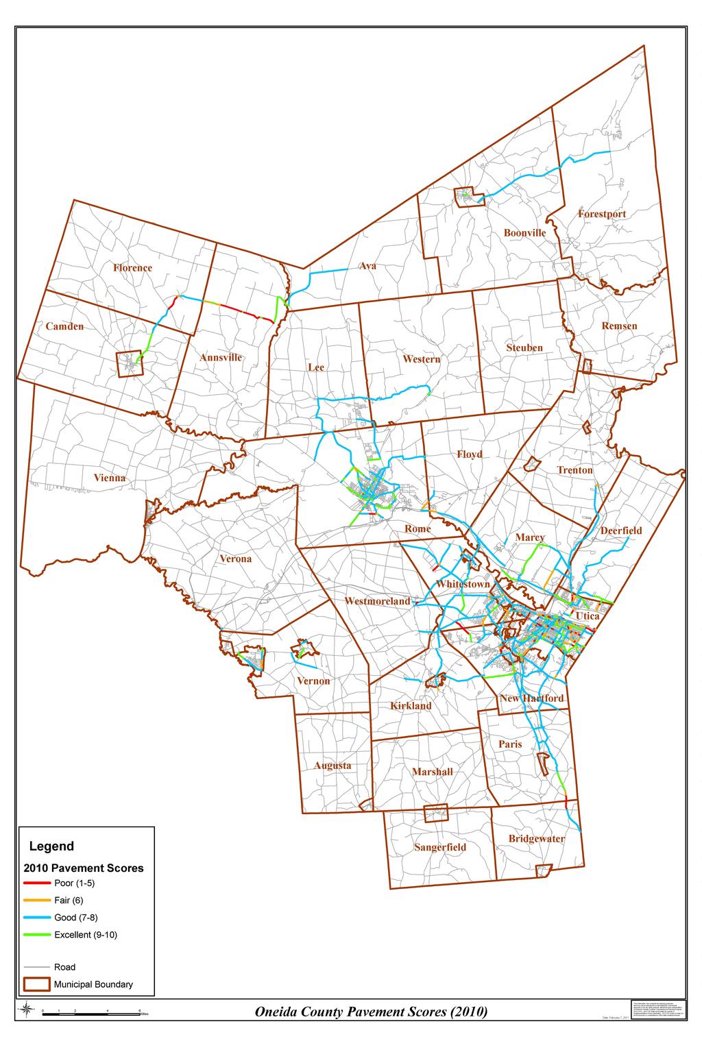
3 TABLE OF CONTENTS Introduction...1 Data Preparation & Methodology... 1 Condition Rating Description... 5 Overall Results... 7 LIST OF CHARTS & TABLES Summary of Miles by Condition. Table Herkimer & Oneida Counties Results Comparison of Surface Conditions by Year. Table Surface Conditions. Chart Surface Condition by Lane Miles. Table Surface Condition by Year. Chart Herkimer County Results Comparison of Surface Condition by Year. Table Surface Conditions. Chart Surface Condition by Lane Miles. Table Surface Condition by Year. Chart Mileage, Condition by Functional Class. Table Mileage Percentage, Condition by Functional Class. Table Oneida County Results Comparison of Surface Conditions by Year. Table Surface Conditions. Chart Surface Condition by Lane Mile. Table Surface Condition by Year. Chart Mileage, Condition by Functional Class. Table Mileage Percentage, Condition by Functional Class. Table Systems Maps Herkimer County...17 Oneida County...18 Road Segment Ratings Maps Zoom in for Detail Online at
4 Introduction In 2010 the Herkimer-Oneida Counties Transportation Study (HOCTS), completed the twentythird year of pavement condition rating for the Non-State Federal-Aid Highway System in Herkimer and Oneida Counties. Road condition data collected in 2009 were used as the base data file for road segment scoring. Additionally, the NYSDOT Local Highway Inventory (LHI), updated annually, provides an inventory of data on locally owned roads including, data on traffic volumes, pavement conditions, functional class information, lane mileage, and other information. The LHI data is incorporated into a formula that sets funding levels for the states Consolidated Local Streets and Highways Improvement Program (CHIPS). The information contained within this report compliments data collected by the New York State Department of Transportation (NYSDOT) for the state Touring System. Together they comprise a complete report of the condition of the Federal-Aid Highway System in Herkimer and Oneida Counties, as well as aid in the production of functional-class mapping of the entire Federal-Aid Highway System statewide. This report provides pavement condition ratings for the non-state Federal-Aid Highway System for This information should assist municipalities in planning maintenance and capital needs. A local municipality Pavement Management System (PMS) should minimally consist of a pavement condition survey and a needs estimating process. This information will also assist NYSDOT in the preparation of project reports, and will aid HOCTS in the understanding of the financial needs that will be required to maintain the surveyed roads in the future. The information is also used by the municipalities to help determine which roads to pave. The scoring for this report occurred in October and November of Scoring for 2009 was performed during October of 2009 and the results are included in the summary tables. Data Preparation & Methodology This was the eighth year that the road scoring process was performed using an automated system. Digital road map files were displayed on a laptop computer used to identify current location and record surface conditions with designated distress features. This method was used throughout the scoring process. This method simplified data entry and greatly improved the efficiency and speed of the scoring process. Preparation for the road scoring had been completed prior to the initiation of fieldwork in order to establish a reasonably efficient driving route that would minimize backtracking. All non-state roads within the Federal-Aid Urban area to be scored were highlighted, and labeled. Maps displaying the non-state Federal Aid Highway System for Herkimer and Oneida Counties can be found on the enclosed CD. Each day's activities were carefully scheduled in advance to determine which roads would be scored. The survey was conducted using a two-person team, a driver and a scorer. Segmentation and Scoring Methodology Change: While performing the field observations for pavement scoring in Oneida and Herkimer Counties, the segmentation and scoring method was used that began in The scoring considered the pavement from white line to white line on the roads and did not include the shoulders. The roads were segmented at every intersection and the pavement in the wheel path was observed. The actual scoring no longer uses an averaging technique along segments, but rather employs an 1
5 on-the-fly editing of segments where significant changes in pavement condition are observed. A more detailed description of these techniques is detailed in the following paragraphs. The segmentation of the road network greatly influences the need, or lack thereof, for averaging pavement scores while collecting field observations. Ultimately this affects the overall accuracy of the data collection and resulting analysis. In years prior to 2005, HOCTS used the NYSDOT road segmentation as described in their sufficiency files. These segments were static even if the pavement condition changed throughout the segment. During this field collection, HOCTS used its internally developed road centerline file which breaks the roads at every intersection and municipal boundary as coded in the E911 master addressing files. This proves to be very helpful in that the actual road work being done almost always correlates with a road intersection or municipal boundary. This results in fewer averaging and scores that are very representative of the actual segment condition. When it is necessary to break an existing segment, the scorer employs real-time GPS tracking capability designed by HOCTS GIS staff. If a long segment of pavement changed condition the scorer creates a segment break at that point and makes a new segment reflecting the actual score for each segment. Additionally, the GPS is extremely helpful for navigating to and from the scoring locations. The real-time graphic on the screen displays position and direction of travel at all times. The true measure of the condition of the pavement is the area that is within the wheel path of the traffic being carried. Any cracking, faulting or other pavement failure issues that were identified within the wheel paths of the road defined the road condition. Conditions outside the white lines or cracks not in the potential wheel paths did not affect the scoring observations. This is consistent with NYSDOT s methodology. Staff were trained in Albany at a NYSDOT course using actual photographs of pavement to develop reliable scoring. The procedure used to rate the roads is documented in the Pavement Condition Rating Manual developed by the NYSDOT. The General Guidelines for Sufficiency Scoring are listed below: 1. Scoring represents an average of conditions throughout the entire scoring section. 2. Scoring is across all lanes of roadway where possible. 3. A dominant distress is only noted when appropriate. 4. If a section has sealed cracks, last years score is used. Credit is given to patched areas only if 1 inch or more material has been applied. 5. Patched spalls are still noted as spalling. 6. Where grader or skin patching has been done, the unimproved portions are scored. 7. If patching exists on all lanes, last years score is used. Credit is given to patched areas only if 1 inch or more material has been applied. 8. Bridge decks and utility cuts are ignored when rating. 9. Widening drop-off cannot occur on curbed sections. 10. Longitudinal cracking of 20% or more shall be considered "general "alligator cracking. Source: NYSDOT Pavement Condition Rating Manual 2
6 The Pavement Conditions Rating Manual uses two rating scales, which together are used to classify highway sections into five general treatment categories. A segment of pavement is rated from 1 (very poor with severe distress features), to 10 (excellent). Highways under construction are rated a 99. The actual score is determined by matching the observed condition of a pavement segment with photographs in the manual until the approximate condition level of the pavement is found. The photographs show typical distress features with specific information to help determine the appropriate rating. A NYDOT chart describing the surface rating scale with associated treatment category is shown below: Condition Scale Frequency Distress Treatment Cost Excellent 9-10 None None No Cost Good 8 Infrequent Very Slight Preventative Maintenance Min. Cost Good 7 Infrequent-Occasional Slight Preventative Maintenance Min + Cost Fair 6 Occasional-Frequent Moderate Corrective Measures Mod. Cost Poor 5 Frequent Mod Severe Rehabilitation High Cost Poor 4 Frequent Severe Rehabilitation High + Cost Very Poor 1-3 Very Frequent Very Severe Reconstruction Max. Cost The scale points were selected by NYSDOT based on the general treatments required by the highway represented in each photograph. There are three photographic scales, one each for rigid (Portland Cement Concrete), overlaid (asphalt overlaid on rigid), and flexible (full depth asphalt) pavement structures. The scored road surface is defined as the wearing course of the pavement structure. The road base is defined as the material supporting the surface, including the lower portion of the pavement and sub-pavement material. The road is also scored by observing distress symptoms at the road surface and comparing them to distress features in the manual. Distress symptoms are defined as cracks or other abnormality observable at posted speeds, which will trigger a treatment category different than the treatment category based on the surface rating alone. A table of dominant distress definitions and their associated codes that were used follows: Report and Maps Online This report and maps of the following areas: Herkimer County, Oneida County, Herkimer Valley Area, Rome Area, Utica Area and Verona Area can be found on the HOCTS web site, Each map can be zoomed in or out and printed. Colored lines define and describe the conditions of the non-state Federal Aid System. The pavement scores are color coded: Red, poor; Orange, fair; Blue, good; and Green, excellent. The line style shows the distress observation. The pavement score is also displayed on each line segment. 3
7 Distress Features Definitions Rigid Pavements FA- SI, SG - Faulting is the vertical displacement of abutting slabs at transverse joints creating a step formation in the pavement surface. Faulting can be seen by looking through the rear view mirror or by viewing the pavement out the rear window of the vehicle. Spalling may occur at PCC joints or at mid-slab. Joint spalling is the cracking, breaking, or chipping of slab edges at the PCC joints usually resulting in fragments with feathered edges. Mid-slab spalling is the loss of surface material generally caused by wear and the improper placements of construction mesh SI, is for isolated spalling, and SG for general spalling. Overlaid Pavements AI, AG WD - Alligator cracking is defined as interconnected or interlaced cracks forming a series of small polygons resembling an alligators hide. AI is assigned for isolated alligator cracking, and AG is assigned for general (>20%) alligator cracking. Widening drop-off occurs when PCC slabs are overlaid with asphalt which extends beyond the slab edges to widen the road. The asphalt may crack at the slab edge and cerate a vertical displacement. Flexible Pavements AI, AG - Alligator cracking is defined as interconnected or interlaced cracks forming a series of small polygons resembling an alligator hide. AI is assigned for isolated alligator cracking, and AG is assigned for general (>20%) alligator cracking Source: NYSDOT Pavement Condition Rating Manual 4
8 Score Condition Rating Description General Condition Rating Description Condition Surface Distress Features 10 Excellent There are no visual deviations from a smooth surface. Pavement recently constructed, reconstructed, or overlaid within the last two years. 9 Excellent Pavement should have no cracks or patches. Flexible pavement recently resurfaced within the past year or two. Overlay pavements may show evidence of some hairline reflection cracking. Rigid pavement joints functioning properly. 8 Good Pavement gives an excellent ride and exhibits infrequent signs of surface deterioration. Flexible pavements begin to show very slight evidence of raveling, cracking, and wheel track wear. Rigid pavements begin to show very slight evidence of surface deteriorating such as cracking, joint spalling, or scaling. Overlay pavements show evidence of very slight refection cracking. 7 Good Pavement gives a good ride but show infrequent to occasional signs of surface deterioration. Flexible pavements show very slight evidence of joint spalling, scaling, or minor, cracking. Overlay pavements show evidence of slight refection cracking and multiple cracking at reflection cracks. 6 Fair Riding quality is noticeably inferior to new pavements, showing infrequent to occasional signs of distress. Surface defects of flexible pavements may include moderate rutting, cracking, and raveling; patch is apparent. Overlay pavements show evidence of slight moderate cracking and raveling along cracks. 5 Poor Riding quality is noticeably inferior to new pavements, but may be tolerable for high speed traffic. Surface defects of pavements are the same as under the 6 rating but are more severe. The riding quality is excellent with no indication of any subsurface shifting. Includes facilities constructed within the last two years. Riding quality is excellent, with no indication of subsurface problems. Facilities reconstructed or rehabilitated within the last two years are included in this category. Pavement shows infrequent evidence of base or sub-base deteriorating. Flexible pavements show evidence of very slight longitudinal cracking in wheelpaths. Rigid pavements show evidence of very slight displacement and pumping. Overlay pavements show evidence of non-joint reflection cracking. Roadway show infrequent to occasional signs of rupture and displacement caused by roadbed movement. Flexible pavements may show slight evidence of rutting and wheelpath cracking. Overlay pavements show evidence of non-joint reflection cracking. Rigid pavements show evidence of very slight displacement and pumping, faulting, and base-related cracking. Overlay pavements show slight evidence of longitudinal cracking. Roadway shows infrequent to occasional signs of distress caused by roadbed movement or inadequate roadbed support. Flexible pavements show evidence of moderate rutting and moderate cracking. Rigid pavements show evidence of moderate pumping, faulting, and base related cracking. Overlay pavements show evidence of reflection cracking and surface distortion. Roadway show occasional signs of distress caused by roadbed movement. The types of distress are the same as under the 6 rating but are more severe for rigid and overlay pavements. 5
9 Score Condition Rating Description General Condition Rating Description Condition Surface Distress Features 4 Poor Pavements have deteriorated to a point where resurfacing is required. Drivability, even at slow speeds, is impaired. Surface defects on flexible pavement include severe rutting, cracking, raveling, and patching. Surface defects or rigid pavements include severe joint spalling, cracking, scaling and patching. Overlay pavements show evidence of severe surface delamination. 3 Poor Pavements have deteriorated to a point where resurfacing is required immediately. Flexible pavements show evidence of severe and frequent scaling, joint spalling, faulting, cracking and patching. Overlay pavements show evidence of severe and frequent surface delamination. Rigid pavements show signs of frequent and severe joint spalling, cracking and scaling. 2 Very Poor Pavement is in extremely deteriorated condition and may require complete reconstruction. Motorists experience discomfort and travel speeds will decrease. 1 Very Poor Pavement is extremely deteriorated condition and in need of immediate action. These facilities are considered impassable at posted speeds. Roadway shows frequent to occasional signs of distress caused by roadbed movement/inadequate roadbed support. Flexible pavements show signs of severe rutting and alligator cracking Rigid pavements show evidence of severe corner and diagonal cracking caused by loss of foundation material under the slab. Severe pumping and faulting is also evident. Overlay pavements show evidence of severe reflection cracking and surface distortion (faulting). Roadway shows frequent signs of severe rutting and alligator cracking and pavements displacement. Rigid pavements show evidence of severe faulting and cracking. Overlay pavements show evidence of frequent rupture and displacement resulting in motorist discomfort. Roadways are in extreme deteriorated condition and may require reconstruction. Flexible, rigid and overlay pavements show evidence of frequent rupture and displacement resulting in motorist discomfort. Roadways are in extremely deteriorated condition and are in need of immediate correction. These facilities air considered impassible at posted speeds. 6
10 Overall Results There were 349 miles of Non-State Federal Aid roads scored in Herkimer and Oneida Counties for Of the 349 miles, 72 miles are located in Herkimer County and 277 miles are located in Oneida County. There was a net difference of 8 miles more of Non-State Federal Aid roads scored in 2010 due to functional class changes of roads in both counties. About 88% of the total non-state system for 2010 was in good to excellent condition. The percentage of roads in good condition increased to 73% in 2010 from 68% in 2009, while roads in excellent condition decreased from 21% in 2009 to 15% in Roads in fair condition remained the same at 7% for Poor roads increased from 3% in 2009 to 5% in The 2010 Herkimer County surface conditions were as follows: 10% excellent, 86% good, 3% fair, and 2% poor. In Herkimer County the roads that had good to excellent conditions scores increased to 96%. The percentage of fair roads decreased from 5% to 3% in Roads in good and fair condition increased, but roads in poor condition also increased by 1% to 5%. Roads in excellent condition decreased substantially from 46% in 2009 to 10% in The 2010 Oneida County surface conditions were as follows: 16% excellent, 70% good, 9% fair, and 5% poor. In Oneida County the percentage of poor and fair roads increased while roads in good condition decreased to 70%. Roads in excellent condition increased by 1% to 16% in It should be noted that the condition results for the road scoring results starting in 2005 can be attributed to the new, more accurate, scoring and methodology changes than used in previous years. 7
11 Table 1 Summary of Miles by Condition 2010 SURFACE CONDITION Herkimer County Poor Fair Good Excellent Total Miles Surface Oneida County Surface Herkimer & Oneida Counties Surface NOTE: Mileage has been rounded. 8
12 Table 2 Herkimer and Oneida Counties Percentage of Surface Year Poor Fair Good Excellent % 14% 36% 23% % 5% 76% 19% % 7% 69% 21% % 7% 73% 15% Chart 1 Herkimer and Oneida Counties 2010 Surface Conditions Excellent 15% Poor 5% Fair 7% Good 73% Poor Fair Good Excellent 9
13 Table 3 Herkimer and Oneida Counties Surface Condition by Miles Year Poor Fair Good Excellent Chart 2 Herkimer and Oneida Counties Surface Rating by Year Miles Poor Fair Good Excellent 10
14 Table 4 Herkimer County Percentage of Surface Year Poor Fair Good Excellent % 6% 64% 29% 2008 <1% 2% 70% 28% 2009 <1% 5% 48% 46% % 3% 86% 10% Chart 3 Herkimer County 2010 Surface Conditions Excellent 10% Poor 2% Fair 3% Good 86% Poor Fair Good Excellent 11
15 Table 5 Herkimer County Surface Condition by Miles Year Poor Fair Good Excellent 2005 < < < Chart 4 Herkimer County Surface Conditions by Year Miles Poor Fair Good Excellent 12
16 Table 6 Herkimer County 2010 Mileage Condition by Functional Class Functional Class Poor Fair Good Excellent 07 Rural Major Collector 1 <1 42 <1 16 Urban Principal Arterial < Urban Collector <1 < Table 7 Herkimer County 2010 Mileage Percentage Condition by Functional Class Functional Class Poor Fair Good Excellent 07 Rural Major Collector 0% 0% 99% 1% 16 Urban Principal Arterial 5% 8% 61% 27% 17 Urban Collector 4% 5% 73% 18% 13
17 Table 8 Oneida County Percentage of Surface Year Poor Fair Good Excellent % 5% 77% 17% 2008 <1% 6% 78% 15% % 8% 74% 15% % 9% 70% 16% Chart 5 Oneida County 2010 Surface Conditions Excellent 16% Poor 5% Fair 9% Good 70% Poor Fair Good Excellent 14
18 Table 9 Oneida County Surface Condition by Miles Year Poor Fair Good Excellent Chart 6 Oneida County Surface Conditions by Year Poor Fair Good Excellent 15
19 Table 10 Oneida County 2010 Mileage Condition by Functional Class Poor Fair Good Excellent 06 Rural Minor Collector 0 0 <1 <1 07 Rural Major Collector Urban Minor Arterial Urban Principal Arterial Urban Collector Table 11 Oneida County 2010 Mileage Percentage Condition by Functional Class Poor Fair Good Excellent 06 Rural Minor Collector 0% 0% 23% 77% 07 Rural Major Collector 14% 6% 61% 19% 14 Urban Minor Arterial 0% 19% 63% 18% 16 Urban Principal Arterial 5% 12% 69% 15% 17 Urban Collector 3% 8% 74% 15% 16
20 17
21 18
Driving Indiana s Economic Growth
 Driving Indiana s Economic Growth IRI/PCR/RUT Field Verification Kumar P. Dave Manager, Road & Pavement Asset Management & Programming, INDOT 03-06-2012 Organization Chart Pavement Division, INDOT David
FLORIDA DEPARTMENT OF TRANSPORTATION
 FLORIDA DEPARTMENT OF TRANSPORTATION FLEXIBLE PAVEMENT CONDITION SURVEY HANDBOOK March 2012 STATE MATERIALS OFFICE Table of Contents Title Page List of Tables... i List of Figures... ii Executive Summary...
An Overview of Mn/DOT s Pavement Condition Rating Procedures and Indices (September 2015)
") An Overview of Mn/DOT s Pavement Condition Rating Procedures and Indices (September 2015) Equipment Mn/DOT currently collects pavement condition data using a Pathway Services, Inc. Digital Inspection Vehicle
An Overview of Mn/DOT s Pavement Condition Rating Procedures and Indices (September 2015) Equipment Mn/DOT currently collects pavement condition data using a Pathway Services, Inc. Digital Inspection Vehicle
An Overview of Mn/DOT s Pavement Condition Rating Procedures and Indices (March 27, 2003)
") An Overview of Mn/DOT s Pavement Condition Rating Procedures and Indices (March 27, 2003) Equipment Mn/DOT currently collects pavement condition data using a Pathway Services, Inc. Video Inspection Vehicle
An Overview of Mn/DOT s Pavement Condition Rating Procedures and Indices (March 27, 2003) Equipment Mn/DOT currently collects pavement condition data using a Pathway Services, Inc. Video Inspection Vehicle
Appendix B Existing ADOT Data Parameters
 Appendix B Existing ADOT Data Parameters Appendix 08/04/03 HPMS by Item Number All records 1 Year of Submittal 2 State Code 3 English or Metric Reporting Units 4 County Code 5 Section Identification (ID)
Kentucky s Surface Transportation System
 Kentucky s Surface Transportation System ROAD AND BRIDGE CONDITIONS, TRAFFIC SAFETY, TRAVEL TRENDS, AND NEEDS MARCH 2018 PREPARED BY WWW.TRIPNET.ORG Founded in 1971, TRIP of Washington, DC, is a nonprofit
WYDOT DESIGN GUIDES. Guide for. Non-NHS State Highways
 WYDOT DESIGN GUIDES Guide for Non-NHS State Highways 2014 GUIDE FOR Non-NATIONAL HIGHWAY SYSTEM (Non-NHS) STATE HIGHWAYS PRESERVATION REHABILITATION RECONSTRUCTION INTRODUCTION This Guide is directed to
2017 Pavement Management Services Pavement Condition Report Salt Lake City, UT
 2017 Pavement Management Services Pavement Condition Report Salt Lake City, UT Prepared by: Data Transfer Solutions, LLC 3680 Avalon Park East Blvd., Suite 200 Orlando, FL 32828 www.dtsgis.com Table of
WYDOT DESIGN GUIDES. Guide for. NHS Arterial (Non-Interstate)
") WYDOT DESIGN GUIDES Guide for NHS Arterial (Non-Interstate) 2014 GUIDE FOR NATIONAL HIGHWAY SYSTEM (NHS) HIGHWAYS (NHS ARTERIALS, Non-Interstate) PRESERVATION REHABILITATION RECONSTRUCTION INTRODUCTION
WYDOT DESIGN GUIDES Guide for NHS Arterial (Non-Interstate) 2014 GUIDE FOR NATIONAL HIGHWAY SYSTEM (NHS) HIGHWAYS (NHS ARTERIALS, Non-Interstate) PRESERVATION REHABILITATION RECONSTRUCTION INTRODUCTION
Pavement and Asset Management from a City s Perspective Mike Rief, PE, DBIA and Andrea Azary, EIT. February 12, 2015
 Pavement and Asset Management from a City s Perspective Mike Rief, PE, DBIA and Andrea Azary, EIT February 12, 2015 What is Pavement Management? At a Network Level: Pavement management refers to a systematic
City of West Des Moines PAVEMENT MANAGEMENT SYSTEM
 City of West Des Moines PAVEMENT MANAGEMENT SYSTEM 12/11/2018 Municipal Street Seminar (11-14-2018) JEFF NASH 1 City Background Information: - West Des Moines current census Population is around 66,000
Pavement Management Program
 Pavement Management Program Public Works Department January 5, 2016 Chad Butzow, P.E. Deputy Director Field Operation Services Public Works Department Brian Martineau Pavement Manager Public Works Department
VDOT s Pavement Management Program. Presented by: Tanveer Chowdhury Maintenance Division, VDOT March 05, 2010
 VDOT s Pavement Management Program Presented by: Tanveer Chowdhury Maintenance Division, VDOT March 05, 2010 Outline Pavement Management network and project level Pavement Data Collection and QA/QC Data
PENNDOT HPMS DATA COLLECTION GUIDE. Bureau of Planning and Research Transportation Planning Division April 2016 (Updated March 2018)
") PENNDOT HPMS DATA COLLECTION GUIDE Bureau of Planning and Research April 2016 (Updated March 2018) State Street Dauphin County NOTES INTRODUCTION The purpose of this document is to provide you with some
PENNDOT HPMS DATA COLLECTION GUIDE Bureau of Planning and Research April 2016 (Updated March 2018) State Street Dauphin County NOTES INTRODUCTION The purpose of this document is to provide you with some
PENNDOT HPMS DATA COLLECTION GUIDE
 PENNDOT HPMS DATA COLLECTION GUIDE Bureau of Planning and Research April 2016 (Updated September 2017) State Street Dauphin County INTRODUCTION The purpose of this document is to provide you with some
Chapter 4 Traffic Analysis
 Chapter 4 Traffic Analysis PURPOSE The traffic analysis component of the K-68 Corridor Management Plan incorporates information on the existing transportation network, such as traffic volumes and intersection
Use of Performance Metrics on The Pennsylvania Turnpike. Pamela Hatalowich, Penn Turnpike Commission Paul Wilke, Applied Research Associates, Inc.
 Use of Performance Metrics on The Pennsylvania Turnpike Pamela Hatalowich, Penn Turnpike Commission Paul Wilke, Applied Research Associates, Inc. Presentation Outline Background- Turnpike Construction
land transport road assets
 land transport road assets land transport road assets Otago Region Information as at June 2007 land transport road assets 2 Purpose of this publication Land Transport New Zealand annually publishes comparative
Secondary Road Program
 Secondary Road Program Joint Legislative Transportation Oversight Committee October 5, 2012 1 Secondary Roads Program The Big Picture The Secondary Road System Needs and Project Types Paved and Unpaved
Road Condition Statistics: Notes and definitions
 Road Condition Statistics: Notes and definitions This note provides definitions used for road condition statistics. It also includes useful information on the source of the data 1. Source The statistics
Smoothing Out the Bumpy Road Ahead
 Julie Hannah, P.E. Technical Services and Asset Management May 11, 2017 Smoothing Out the Bumpy Road Ahead Nationwide D = Poor, At Risk Conditions & Capacity Pavement Condition & Congestion Nationwide
land transport road assets
 land transport road assets land transport road assets Westland District West Coast Region Information as at June 2006 land transport road assets 2 Purpose of this publication Land Transport New Zealand
2017 Temporary traffic control guidelines for pedestrians. v.2
 2017 Temporary traffic control guidelines for pedestrians v.2 Temporary Traffic Control Guidelines for Pedestrians (2017) The safety and mobility of pedestrians, cyclists and motorists must be considered
Driveway Design Criteria
 Design Manual Chapter 5 - Roadway Design 5L - Access Management 5L-4 Driveway Design Criteria A. General For efficient and safe operations, access drives and minor public street intersections can be improved
TEXAS DEPARTMENT OF TRANSPORTATION. Condition of Texas Pavements
 TEXAS DEPARTMENT OF TRANSPORTATION Condition of Texas Pavements PMIS Annual Report FY 2007-2010 Condition of Texas Pavements Pavement Management Information System (PMIS) Annual Report FY 2007-2010 Prepared
TOWN OF SHUTESBURY PAVEMENT MANAGEMENT STUDY SCENARIO 2
 TOWN OF SHUTESBURY PAVEMENT MANAGEMENT STUDY SCENARIO 2 FRANKLIN REGIONAL COUNCIL OF GOVERNMENTS 425 Main Street, Greenfield, MA 01301 413-774-3167 June 2004 TOWN OF SHUTESBURY PAVEMENT MANAGEMENT STUDY
Policy Number: Effective: 07/11/14 Responsible Division: Planning Date: 07/11/2014 FUNCTIONAL CLASSIFICATION AMENDMENT POLICY
 Policy Number: 2014-025 Effective: 07/11/14 Responsible Division: Planning Date: 07/11/2014 FUNCTIONAL CLASSIFICATION AMENDMENT POLICY POLICY STATEMENT: The Northeast Ohio Areawide Coordinating Agency
TEXAS DEPARTMENT OF TRANSPORTATION. Condition of Texas Pavements
 TEXAS DEPARTMENT OF TRANSPORTATION Condition of Texas Pavements PMIS Annual Report FY 2008-2011 Condition of Texas Pavements Pavement Management Information System (PMIS) Annual Report FY 2008-2011 Prepared
2018 ROAD MAINTENANCE PROGRAM
 2018 ROAD MAINTENANCE PROGRAM John Tiger Anastasi Town of Bethlehem Superintendent of Highways June 27, 2018 AGENDA Why do we maintain our roads? How is the Road Maintenance Plan developed? The process
ONTARIO REGULATION 239/02 MUNICIPAL ACT MINIMUM MAINTENANCE STANDARDS FOR MUNICIPAL HIGHWAYS
 ONTARIO REGULATION 239/02 made under the MUNICIPAL ACT Made: July 23, 2002 Filed: August 8, 2002 MINIMUM MAINTENANCE STANDARDS FOR MUNICIPAL HIGHWAYS Definitions 1. (1) In this Regulation, cm means centimetres;
PASER Road Survey. For Berrien County, Michigan
 The State of Michigan Transportation 2003-2010 PASER Road Survey For Berrien County, Michigan Prepared by the Southwest Michigan Planning Commission 185 E. Main St. Suite 701 Benton Harbor, MI 49022 (269)
Sponsored by the Office of Traffic and Safety of the Iowa Department of Transportation NOVEMBER 2001 CTRE
 PAVED SHOULDERS ON PRIMARY HIGHWAYS IN IOWA: AN ANALYSIS OF SHOULDER SURFACING CRITERIA, COSTS, AND BENEFITS EXECUTIVE SUMMARY Sponsored by the Office of Traffic and Safety of the Iowa Department of Transportation
Township of Springwater
 Township of Springwater Approved: November 2008 Effective: Date of Passing Next Review: TBD Department: Public Works Subject: Sidewalks Policy Number: A09 SI A. Authority This policy shall be approved
Southeaster Pavement Preservation Partnership 2010 Update Welcome to Tennessee. Michael J. Doran, P.E. Maintenance Division
 Southeaster Pavement Preservation Partnership 2010 Update Welcome to Tennessee Michael J. Doran, P.E. Maintenance Division Why are we here today? The Solution Background Information Geographic Locations
The City of Port Moody 2013 Paved Road Network Condition Assessment
 The City of Port Moody 2013 Paved Road Network Condition Assessment February 2014 Contents Objectives Data Collection Road Network Present Conditions in 2013 Road Network Assessment and Comparison to other
2016 FACT SHEET ENGINEERING STREET OPERATIONS. Engineering Street Operations net 2016 budget is $5,199,900 WHAT IS ENGINEERING STREET OPERATIONS?
 WHAT IS STREET OPERATIONS? This section maintains approximately 570 km of major, collector and residential roads throughout Saanich. Some of the major programs include road surface treatments (pothole
Parks Highway: MP Lucus Road to Big Lake Road
 2 Purpose and Need 2.1 Corridor History The Parks Highway is a 324-mile long Rural Interstate Highway that extends from its intersection with the Glenn Highway north to Fairbanks, Alaska. The Parks Highway
Roadway Conditions as Contributing Factors in Florida Traffic Crashes
 Roadway Conditions as Contributing Factors in Florida Traffic Crashes Michael R. Baltes and Xuehao Chu Center for Urban Transportation Research University of South Florida 4202 East Fowler Avenue, CUT
Pavement Management Report. City Council Meeting of May 21, 2013
 Pavement Management Report City Council Meeting of May 21, 2013 Previous Meetings Summary In February, we presented the 2012 pavement survey and our consultant presented general pavement management strategies
Analysis of Run-Off-Road Crashes in Relation to Roadway Features and Driver Behavior
 Analysis of Run-Off-Road Crashes in Relation to Roadway Features and Driver Behavior Ertan Örnek University of Wisconsin, Madison Traffic Operations Lab 141 NW Barstow Street Waukesha, WI 53187 ornek@wisc.edu
Lake Waterford Community Association Meeting. November 15, 2016
 Lake Waterford Community Association Meeting November 15, 2016 Introduction Staff Introduction Project Overviews - Completed Projects - Pavement Management Program - Pasadena Road Sidewalk Improvements
CHAPTER 7 ACCESS MANAGEMENT. Background. Principles of Access Management. Hennepin County Transportation Systems Plan (HC-TSP)
") CHAPTER 7 ACCESS MANAGEMENT Background Principles of Access Management Hennepin County Transportation Systems Plan (HC-TSP) Chapter 7 Access Management 7.1 Background Access management has become an important
CHAPTER 7 ACCESS MANAGEMENT Background Principles of Access Management Hennepin County Transportation Systems Plan (HC-TSP) Chapter 7 Access Management 7.1 Background Access management has become an important
Recommended Roadway Plan Section 2 - Land Development and Roadway Access
 Recommended Roadway Plan Section 2 - Land Development and Roadway Access SECTION 2 Land Development and Roadway Access 2.1 Land Use and Access Management The Federal Highway Administration (FHWA) defines
NEW JERSEY DEPARTMENT OF TRANSPORTATION RIDE QUALITY SPECIFICATION AND CASE STUDIES
 NEW JERSEY DEPARTMENT OF TRANSPORTATION RIDE QUALITY SPECIFICATION AND CASE STUDIES BY NARINDER S. KOHLI, P.E. PRINCIPAL ENGINEER PAVEMENT DESIGN, NJDOT (609) 530 8140 NARINDER.KOHLI@DOT.STATE.NJ.US RIDE
C ITY OF B EDFORD H EIGHTS
 C ITY OF B EDFORD H EIGHTS T ABLE OF C ONTENTS 1. Executive Summary... 2 2. Background... 3 3. PART I: 2016 Pavement Condition... 8 4. PART II: 2018 Current Backlog... 13 5. PART III: Maintenance &
Access Location, Spacing, Turn Lanes, and Medians
 Design Manual Chapter 5 - Roadway Design 5L - Access Management 5L-3 Access Location, Spacing, Turn Lanes, and Medians This section addresses access location, spacing, turn lane and median needs, including
Performance of Ultra-Thin Bounded Wearing Course (UTBWC) Surface Treatment on US-169 Princeton, Minnesota. Transportation Research
 Surface Treatment on US-169 Princeton, Minnesota. Transportation Research") 2007-18 Performance of Ultra-Thin Bounded Wearing Course (UTBWC) Surface Treatment on US-169 Princeton, Minnesota Take the steps... Research...Knowledge...Innovative Solutions! Transportation Research
2007-18 Performance of Ultra-Thin Bounded Wearing Course (UTBWC) Surface Treatment on US-169 Princeton, Minnesota Take the steps... Research...Knowledge...Innovative Solutions! Transportation Research
Pavement Markings (1 of 3)
") Pavement Markings (1 of 3) DESCRIPTION AND DEFINITION Disadvantages Relatively high cost (over typical Crash reduction as yet unknown painted edge line) No tactile effect The STOP AHEAD pavement marking
Pavement Markings (1 of 3) DESCRIPTION AND DEFINITION Disadvantages Relatively high cost (over typical Crash reduction as yet unknown painted edge line) No tactile effect The STOP AHEAD pavement marking
State of Nevada Department of Transportation Materials Division
 State of Nevada Department of Transportation Materials Division METHOD OF TEST FOR EVALUATION OF PAVEMENT RIDE QUALITY USING INERTIAL PROFILING SYSTEMS SCOPE This test method describes the procedure used
Roadway Classification Design Standards and Policies. Pueblo, Colorado November, 2004
 Roadway Classification Design Standards and Policies Pueblo, Colorado November, 2004 Table of Contents Page Chapter 1. General Provisions 1.1 Jurisdiction 3 1.2 Purpose and Intent 3 1.3 Modification 3
MNDOT PAVEMENT DESIGN MANUAL
 MNDOT PAVEMENT DESIGN MANUAL Chapter 6 Ramps, Shoulders, Turn Lanes & Miscellaneous Pavements MnDOT Pavement Engineer Date Contents Introduction... 1 600 Ramps and Loops... 1 610 - Shoulders... 2 620 -
County of Spartanburg South Carolina
 County of Spartanburg South Carolina Traffic Calming Program June 2012 (Revised/Program on Hold) PURPOSE The potential negative impacts from vehicular traffic on residential roads have been a longstanding
PASER Road Survey. For Berrien County, Michigan
 The State of Michigan Transportation 2003-2014 PASER Road Survey For Berrien County, Michigan Prepared by the Southwest Michigan Planning Commission 376 W Main St Benton Harbor, MI 49022 (269) 925-1137
Steps to Conducting a Complete Streets Assessment
 Steps to Conducting a Complete Streets Assessment Familiarize yourself with Complete Streets Read through the Complete Streets Assessment Guidelines. This will give you an idea of what Complete Streets
Chapter 2: Roadways 2.1 FUNCTIONAL CLASSIFICATION. Washington County TSP 2035 Existing Conditions and Future Needs Report **DRAFT 11/7/12**
 Chapter 2: Roadways 2.1 FUNCTIONAL CLASSIFICATION There are numerous ways in which the concept of roadway functional classification is defined and interpreted. federal, state, regional and some city definitions
South Carolina Department of Transportation. Engineering Directive
 South Carolina Department of Transportation Engineering Directive Directive Number: ED-22 Effective: December 16, 2009 Subject: References: Purpose: This Directive Applies to: Considerations for Bicycle
Chapter 5 FUNCTIONAL CLASSIFICATION
 Chapter 5 FUNCTIONAL CLASSIFICATION Functional classification is a system by which streets and roadways may be distinguished by types according to their function within the entire transportation network.
City of Wayzata Comprehensive Plan 2030 Transportation Chapter: Appendix A
 A1. Functional Classification Table A-1 illustrates the Metropolitan Council s detailed criteria established for the functional classification of roadways within the Twin Cities Metropolitan Area. Table
CHAPTER 16 PEDESTRIAN FACILITIES DESIGN AND TECHNICAL CRITERIA TABLE OF CONTENTS
 CHAPTER 16 PEDESTRIAN FACILITIES DESIGN AND TECHNICAL CRITERIA TABLE OF CONTENTS Section Title Page 16.1 General... 16-1 16.1.1 AASHTO Reference... 16-1 16.1.2 ADA Requirements... 16-1 16.2 Sidewalks...
City of Davis Pavement Management Program
 City of Davis Pavement Management Program Davis Street and Bike Path System 163 centerline miles of streets (33 million square feet) 34.6 miles of arterials 21% 22.8 miles of collectors 14% 103.9 miles
CHAPTER 7 CIRCULATION
 CHAPTER 7 CIRCULATION A township s transportation network links its population with the surrounding communities. Transportation networks, including public and private, provide the means by which township
APPENDIX I-A Kings County Regional Transportation Plan. Appendix A Page A-1 STATE ROUTES
 APPENDIX I-A STATE ROUTES Interstate 5 SR 33 SR 41 SR 43 SR 137 SR 198 SR 269 (See under City of Avenal) (See Figure 4-2 and 4-3 for Rural and Urban Functional Classifications) Appendix A Page A-1 INTERSTATE
POTHOLES IN EDMONTON. Updated: April 4, 2013
 Updated: April 4, 2013 Abstract Every year the City of Edmonton spends a few million dollars to fill a few hundred thousand potholes. Are potholes just a fact of life, or can we do something about them?
Geometric Design Tables
 Design Manual Chapter 5 - Roadway Design 5C - Geometric Design Criteria 5C-1 Geometric Design Tables A. General The following sections present two sets of design criteria tables - Preferred Roadway Elements
Who is Toole Design Group?
 2018 AASHTO Bike Guide Status Update NCHRP 15 60 Amalia Leighton Cody, PE, AICP & Kenneth Loen, PE Washington APWA October 4, 2018 Who is Toole Design Group? TDG is a full service engineering, planning
DEVELOPMENT OF A PAVEMENT REHABILITATION STRATEGY FOR NATIONAL ROADS IN QUEENSLAND
 DEVELOPMENT OF A PAVEMENT REHABILITATION STRATEGY FOR NATIONAL ROADS IN QUEENSLAND Presenter: Tyrone Toole, ARRB Group Scope Background Objectives Road network data and analysis Current and potential investment
PLACEMENT OF SIGNS RECOMMENDED PRACTICES SUB-SECTION
 Page 1 of 6 RECOMMENDED PRACTICES PART SECTION SUB-SECTION HIGHWAY SIGNS GENERAL General Proper positioning of signs is an important element in the overall control of traffic within a roadway network.
DETECTABLE WARNING SURFACES SHALL BE PROVIDED AT THE FOLLOWING LOCATIONS ON PEDESTRIAN ACCESS ROUTES:
 GENERAL NOTES: CURB NOTES: 5'-0" MIN 5'-0" 5'-0" MIN 1. 2. THESE SHEETS ARE IN ACCORDANCE WITH THE AMERICANS WITH DISABILITIES ACT (ADA), AND THE REQUIREMENTS OF THE 2011 PROPOSED ACCESSIBILITY GUIDELINES
City of Vallejo Traffic Calming Toolbox
 City of Vallejo Traffic Calming Toolbox June 1, 2013 Final Table of Contents Introduction... 1 Non-Physical Devices... 3 High-Visibility Crosswalk... 3 In Pavement Lighted Crosswalk... 4 Rapid Flashing
Access requests to County streets and roadways are processed through one of the following methods:
 13.1 GENERAL APPLICATION PROCESS Access requests to County streets and roadways are processed through one of the following methods: A. Planned Developments may set general locations for access points.
3-13 UFC - GENERAL PROVISIONS AND GEOMETRIC DESIGN FOR ROADS, STREETS, WALKS, AND OPEN
 maintenance, and erosion. Stability is required to maintain the integrity of the pavement structure, and a slope stability analysis should be conducted for cuts and fills greater than 15 feet. For lower
CITY OF WEST LAKE HILLS. Forest View Neighborhood Traffic Calming Study
 CITY OF WEST LAKE HILLS 901 South Mopac Expressway Building V, Suite 220 Austin, Texas 78746 Texas P.E. Firm Registration No. F-929 Klotz Associates Final Report Submittal: March 20, 2015 Revised Final
50 Year Roads: Don't Accept Anything Less
 50 Year Roads: Don't Accept Anything Less Prepared By Thomas O. Malerk Director of Transportation Engineering Florida Concrete & Products Association NACE Annual Meeting April 22, 2015 Presented by Roger
County of Greenville South Carolina. Traffic Calming Program Neighborhood Traffic Education Program and Speed Hump Program
 County of Greenville South Carolina Traffic Calming Program Neighborhood Traffic Education Program and Speed Hump Program (rev) August 2008 I. PURPOSE The potential negative impacts from vehicular traffic
TRAFFIC ACCIDENT ANALYSIS
 TRAFFIC ACCIDENT ANALYSIS Westheimer at Chimney Rock and Westheimer at Dunvale Prepared for Prepared by Klotz Associates, Inc. 1160 Dairy Ashford, Suite 500 Houston, Texas 77079 The preparation of this
Accuracy and Precision of High-Speed Field Measurements of Pavement Surface Rutting and Cracking
 Accuracy and Precision of High-Speed Field Measurements of Pavement Surface Rutting and Cracking Pedro A. Serigos, MSE, MSStat - serigosp@utexas.edu Jorge A. Prozzi, PhD Andre de Fortier Smit, PhD Mike
Department of Internal Affairs Mandatory Non-Financial Performance Measures 2013 Roads and Footpaths
 Road Asset Technical Accord - RATA The Centre of Excellence for Road Asset Planning in the Waikato Region Department of Internal Affairs Mandatory Non-Financial Performance Measures 2013 Roads and Footpaths
Traffic Assessment for Woodhaven Redevelopment. City of Rome Oneida County, New York. March 2, 2018
 March 2, 2018 Traffic Assessment for Woodhaven Redevelopment City of Rome Oneida County, New York Prepared for: City of Rome 198 N. Washington Street Rome, NY 13440 Prepared by: C.T. MALE ASSOCIATES 50
Chapter 3 DESIGN SPECIFICATIONS
 Brampton PathWays Planning and Design Guidelines 27 Chapter 3 DESIGN SPECIFICATIONS 3.1 CLASS 1 MULTI-USE PATH Off-road multi-use trails are the backbone of the Brampton PathWays Network. They are typically
APPENDIX A TWO-LANE RURAL ROADS ELEMENTS OF DESIGN CREST VERTICAL CURVES
 APPENDIX A TWO-LANE RURAL ROADS ELEMENTS OF DESIGN CREST VERTICAL CURVES 1. Two-lane Rural Roads 1.1 Introduction The definition of rural area can be derived from the definition of urban areas. Officially,
BICYCLE LEVEL OF SERVICE for URBAN STREETS. Prepared by Ben Matters and Mike Cechvala. 4/16/14 Page 1
 BICYCLE LEVEL OF SERVICE for URBAN STREETS Prepared by Ben Matters and Mike Cechvala 4/16/14 Page 1 Introduction The methodology used for the Bicycle (BLOS) analysis is from the Highway Capacity Manual
Keeping good roads good
 Pavement Preservation (PP) in the State of California- Protecting Their Road and Street Investment R. Gary Hicks PhD, PE CP2 Center, Chico CA Prepared for the 3 rd International Pavement Maintenance Technology
Asphalt Recycling and Pavement Preservation in Hillsborough County, Florida
 Asphalt Recycling and Pavement Preservation in Hillsborough County, Florida Roger Cox, P.E. Manager coxw@hillsboroughcounty.org 813.272.5912 Public Works Department Systems Planning Discussion Points Hillsborough
Welcome. Thank you for your interest in the Lewis & Clark Viaduct Concept Study
 Welcome Thank you for your interest in the Lewis & Clark Viaduct Concept Study Please use the arrows in the upper left hand corner to navigate through the presentation. Use the envelope icon to ask a question
TRAFFIC IMPACT ANALYSIS
 TRAFFIC IMPACT ANALYSIS FOR THE CHAMPAIGN UNIT#4 SCHOOL DISTRICT PROPOSED HIGH SCHOOL (SPALDING PARK SITE) IN THE CITY OF CHAMPAIGN Final Report Champaign Urbana Urbanized Area Transportation Study 6/24/2014
ADOT Maintenance Data Collection Guide
 ADOT Maintenance Data Collection Guide January 1, 2009 Prepared for Arizona Department of Transportation Prepared by Jani Demaree and Cambridge Systematics, Inc. 100 CambridgePark Drive, Suite 400 ADOT
3 ROADWAYS 3.1 CMS ROADWAY NETWORK 3.2 TRAVEL-TIME-BASED PERFORMANCE MEASURES Roadway Travel Time Measures
 ROADWAYS Approximately 6 million trips are made in the Boston metropolitan region every day. The vast majority of these trips (80 to percent, depending on trip type) involve the use of the roadway network
Roadway Design Manual
 Roadway Design Manual Manual Notice Archive by Texas Department of Transportation (512) 302-2453 all rights reserved Manual Notice 2009-1 From: Manual: Mark A. Marek, P.E Roadway Design Manual Effective
NEIGHBORHOOD TRAFFIC CALMING POLICY
 NEIGHBORHOOD TRAFFIC CALMING POLICY I. PURPOSE The City of Kent continually strives to strengthen and protect its neighborhoods by improving the quality of life in residential areas. Traffic conditions
Kalamazoo County Weekly Project Updates from the Cities of Portage, Kalamazoo and the Kalamazoo County Road Commission
 FOR IMMEDIATE RELEASE Date: October 31, 2014 Kalamazoo County Weekly Project Updates from the Cities of Portage, Kalamazoo and the Kalamazoo County Road Commission Kalamazoo, MI- In a collaborative effort
Creek Trash Assessment (CTA) Methodology (Demonstration: Mill Run Creek, Cheltenham, Pa.)
 Methodology (Demonstration: Mill Run Creek, Cheltenham, Pa.)") Creek Trash Assessment (CTA) Methodology (Demonstration: Mill Run Creek, Cheltenham, Pa.) Mill Run Creek emerges from a storm sewer in Philadelphia to an open creek in Cheltenham. The Creek downstream
Creek Trash Assessment (CTA) Methodology (Demonstration: Mill Run Creek, Cheltenham, Pa.) Mill Run Creek emerges from a storm sewer in Philadelphia to an open creek in Cheltenham. The Creek downstream
City of Homewood Transportation Plan
 City of Homewood Transportation Plan Prepared for: City of Homewood, Alabama Prepared by: Skipper Consulting, Inc. May 2007 TABLE OF CONTENTS INTRODUCTION... 1 BACKGROUND INFORMATION... 1 EXISTING TRANSPORTATION
RURAL HIGHWAY SHOULDERS THAT ACCOMMODATE BICYCLE AND PEDESTRIAN USE (TxDOT Project ) June 7, Presented by: Karen Dixon, Ph.D., P.E.
 June 7, Presented by: Karen Dixon, Ph.D., P.E.") RURAL HIGHWAY SHOULDERS THAT ACCOMMODATE BICYCLE AND PEDESTRIAN USE (TxDOT Project 0-6840) June 7, 2016 Presented by: Karen Dixon, Ph.D., P.E., TTI Team: Kay Fitzpatrick, Raul Avelar, & Subasish Das Project
RURAL HIGHWAY SHOULDERS THAT ACCOMMODATE BICYCLE AND PEDESTRIAN USE (TxDOT Project 0-6840) June 7, 2016 Presented by: Karen Dixon, Ph.D., P.E., TTI Team: Kay Fitzpatrick, Raul Avelar, & Subasish Das Project
Summary of Findings Concerning Longitudinal Cracking on 16' Wide Ramps
 Summary of Findings Concerning Longitudinal Cracking on 16' Wide Ramps Office of Pavement Engineering October 14, 2003 Abstract: This paper summarizes the current practice in ODOT regarding the construction
Traffic Accident Data Processing
 Traffic Accident Data Processing D o n a l d F. P e t t y Engineer of Traffic Research and Surveys Indiana State Highway Commission The following is a portion of the Highway Safety Program Standards developed
ENGINEERING DRIVER SAFETY INTO PAVEMENT PRESERVATION
 ENGINEERING DRIVER SAFETY INTO PAVEMENT PRESERVATION 2015 TxDOT Short Course Miguel Arellano, P.E. Austin District Pavement Engineer October 13, 2015 Table of Contents 1 Goals: Overall Reduction in Crashes
This Chapter sets forth the minimum design, technical criteria and specifications to be used in the preparation of all roadway plans.
 4.1 GENERAL This Chapter sets forth the minimum design, technical criteria and specifications to be used in the preparation of all roadway plans. These Roadway Standards are for new construction and modification
CORE MPO Non-motorized Transportation Plan. Appendix D
 Appendix D Technical Report on Methodology of Bikeway Conditions Analysis: Bicycle Level of Service Model, version 2, for Segments This page is intentionally left blank. Methodology of Bikeway Conditions
Dr. Naveed Anwar Executive Director, AIT Consulting Affiliated Faculty, Structural Engineering Director, ACECOMS
 Dr. Naveed Anwar Executive Director, AIT Consulting Affiliated Faculty, Structural Engineering Director, ACECOMS Overview Highway Functions and Classifications Highway Design Components Design Control
Paul Vraney Bureau of Project Development 02/11/2016
 Paul Vraney Bureau of Project Development 02/11/2016 ADA background & alterations definition Design considerations Provide sufficient layout data Curb ramp selection Maximum curb ramp and gutter slopes