Walk Bike Dutchess. Chapter 3: Design Guidelines
|
|
|
- Emery Gaines
- 5 years ago
- Views:
Transcription
. Design details will depend on the specific site and context, as well as the project s funding source.")
1 Chapter 3: Design Guidelines This chapter provides design guidance for walking and bicycling facilities based on national and state manuals, the Greenway Guides, other best practices, and input from NYSDOT-Region 8 and the Dutchess County Department of Public Works (DCDPW). Design details will depend on the specific site and context, as well as the project s funding source. Since standards change over time, consult NYSDOT and DCDPW as well as references such as those listed at the end of the chapter for current guidance. A. Sidewalks Sidewalks provide a dedicated space for people to walk and dramatically increase safety for people walking along a street. They also add to quality of life by providing space for people to sit outdoors, children to play, and residents to interact. Locations 1 Both sides of the street along central circulation streets, in commercial districts, near schools, and in residential areas with more than four units per acre. Streets versus Roads : We use the term street to refer primarily to local streets in centers (cities, villages, town centers, and hamlets) that provide access to stores, housing, and other community uses. Streets are characterized by relatively slow speeds, short blocks with sidewalks and crosswalks, on-street parking, street trees, close building setbacks, and a mix of travel types, including walking, bicycling, and transit. Roads are typically located outside of centers in rural or suburban areas and are characterized by higher speeds, more limited access, and widelyspaced intersections for efficient travel between centers. Roads often include shoulders for walking and bicycling; some include sidewalks. Roads include most County and State roads, although they should conform to street standards as they pass through centers. At least one side of the street in residential areas with one to four units per acre. Optional: One side of the street or wide shoulders in areas with less than one unit per acre. Design 2 Width: Typically five foot minimum exclusive of curb; wider in town center, village, and hamlet commercial areas, or other high-use areas. Wide sidewalks in the Village of Rhinebeck provide room for walking as well as landscaping, seating, and other amenities. 1 Dutchess County Department of Planning & Development; Greenway Guide B2: Walkable Communities 2 Ibid. 32


2 Buffer: Provide a buffer between the curb and sidewalk where possible to separate people from traffic and provide room for street trees, signs, utilities, lighting, and snow storage. A five to eight foot buffer is recommended; it buffer could be wider based on traffic volume and/or speed. Curbs: Recommended on all sidewalks to provide a physical barrier between vehicle traffic and people walking. Drainage can be provided through inlets or gaps in curbs. If a curb is not feasible, provide a buffer. Surface/Materials: Concrete is the most durable and stable. Bluestone or brick pavers may be appropriate in historic areas. Driveways: Continue the sidewalk material across driveways to alert drivers to the presence of the sidewalk and potential people walking. Slope driveways down to the street, rather than sloping the sidewalk at the driveway. Utilities: Ensure that utility poles, street lights, and other objects do not interfere with sidewalks. On streets where sidewalks may be installed in the future, place utility poles outside the future sidewalk location. Sidewalks that cross driveways should be level and clearly designed as a sidewalk rather than part of the driveway, similar to these in the Village of Fishkill and Town of Poughkeepsie (top image source: Accessible Sidewalks and Street Crossings, FHWA). Bicycling on Sidewalks: In most cases, bicycling on the sidewalk is less safe than riding on the street. Motorists exiting or entering driveways and intersections do not expect a person bicycling on the sidewalk, and have little room to stop. People walking on the sidewalk may stop or change direction abruptly. Bicycling visibly and predictably on the street, in the same direction of traffic, is typically recommended. 33
3 Accessibility 3 The US Access Board provides detailed accessibility guidelines for streets and sidewalks. See their website or contact NYSDOT or DCDPW for current standards. Grade (Running Slope): The running slope for a sidewalk should not exceed the grade of the adjacent street. Generally, limit running slope to no more than five percent. the bottom of curb ramps, the edge of a raised crosswalk, and borders of medians, pedestrian refuge islands, railroad crossings and train boarding platforms. Alternate Routes: In construction zones, provide an alternate accessible route if needed. Cross-Slope: Maximum cross-slope of two percent. This includes sidewalks across driveways. Flare Slope: Maximum flare slope of ten percent for driveway crossings and curb ramps. Surface texture: Surfaces should be relatively smooth, yet slipresistant. Openings/Gaps: Restrict grate openings and other gaps to less than a half-inch sphere (so a cane tip cannot slip through). Curb Ramps: Provide curb ramps at all intersections and midblock crossings with sidewalks. For new construction, provide a ramp for each crosswalk, perpendicular to the curb and aligned with the crosswalk. Construct curb ramps to be flush with the street, and provide a level landing at the top and bottom of the ramp. Detectable Warnings: Provide detectable warnings at all transition points between the sidewalk and street, such as at Sidewalks should provide distinct zones for walking, street furniture and trees or other plantings, and entrances to stores or other buildings (source: Accessible Sidewalks and Street Crossings, FHWA). 3 United States Access Board, Proposed Guidelines for Pedestrian Facilities in the Public Right-of-Way (2011); FHWA, Accessible Sidewalks and Street Crossings- An Informational Guide. FHWA-SA
4 35

 help shorten crosswalks and slow turning traffic.")
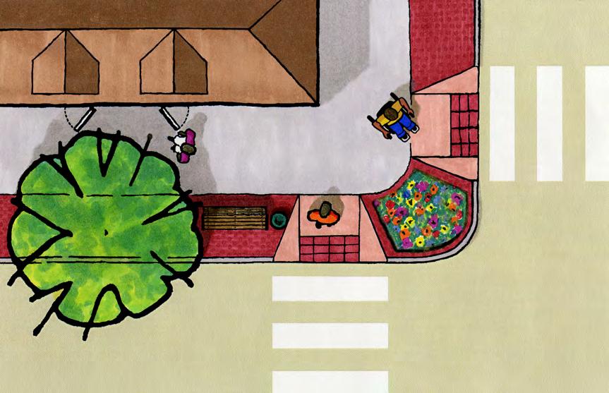
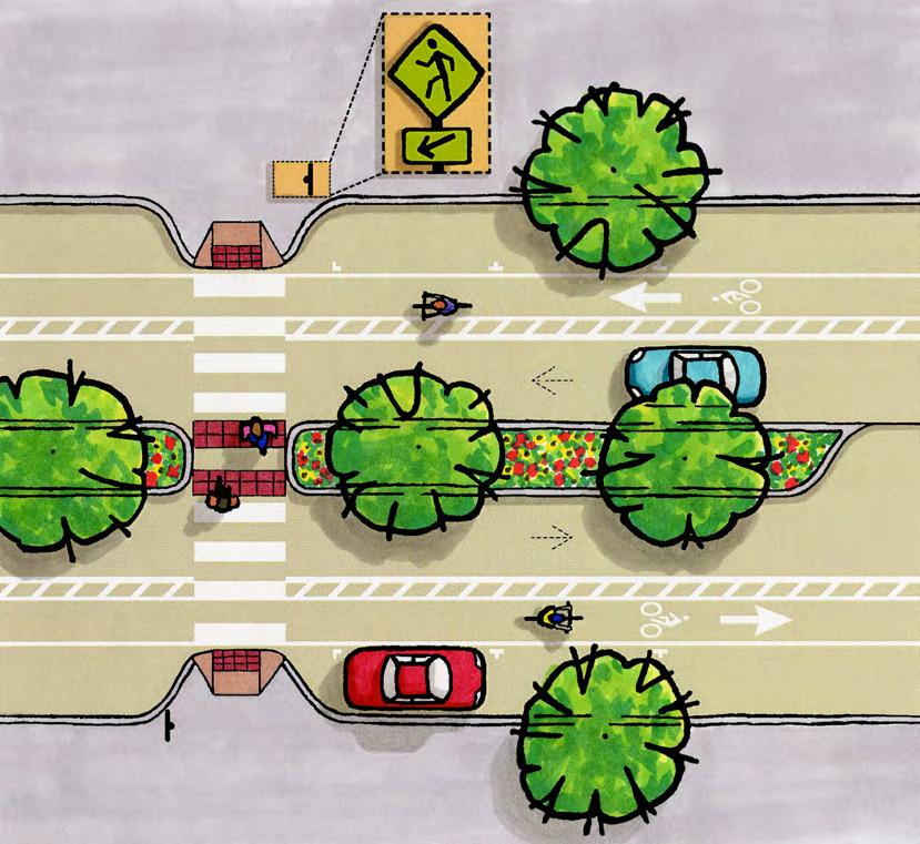
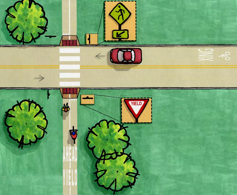
5 B. Marked Crosswalks Marked crosswalks alert drivers to locations where pedestrians may cross and encourage people to cross in a consistent location. People walking may cross at any leg of an intersection unless specifically prohibited, even if the crosswalk is not marked. Locations At intersections: On all legs of intersections with significant walking activity, unless there is an engineering reason to limit access. Design 4 Length: As short as possible. Small corner radii (tight corners) help shorten crosswalks and slow turning traffic. Curb extensions can be used to shorten crosswalks and increase the visibility of people crossing, and their view of traffic. Consider the turning radius of trucks and buses where appropriate to insure that they can turn the corner without encroaching on the curb ramp. Width: Typically 6 to 10 feet wide, depending on the width of the adjacent sidewalks and amount of walking activity. At all crossings with pedestrianactivated signals. Mid-block: At selected high-use midblock crossings. Supplement these crosswalks with signs, traffic calming elements, and lighting to ensure the person crossing is visible. The location of any crosswalk should balance convenience for people walking (since if it is not convenient, it will not be used) with visibility to drivers, who must be able to see people crossing in time to slow down and yield. For crossings not controlled by a traffic signal or Stop or Yield sign, an engineering study can help determine the best crosswalk location. Continental (top) and ladder (bottom, in the Town of Poughkeepsie) crosswalks are highly visible to drivers (top photo source: NACTO.org). Marking: High-visibility continental (preferred) or ladder crosswalk striping is recommended. Install advance stop lines (at least four feet back) at signalized or stop-controlled crosswalks. Install advance yield lines (20 to 50 feet back) at uncontrolled crosswalks. Material: Inlay tape or thermoplastic is recommended, because they last longer and are more reflective and slip-resistant than paint. Crosswalks should be smooth, slip-resistant, and highly visible, especially at night. 4 Dutchess County Department of Planning & Development; Greenway Guide B2: Walkable Communities; WalkingInfo.org; MUTCD (2009 edition). 36


6 Raised crosswalks may be useful to reduce vehicle speeds at crosswalks. They are most effective at locations with consistent walking activity, so that drivers see people crossing and understand why it is important to reduce their speed. See Traffic Calming for additional options. Signage To alert drivers of mid-block crosswalks, install advance pedestrian crossing signs in advance of the crosswalk and pedestrian crossing location signs at the crosswalk. At uncontrolled multi-lane approaches, Yield Here to Pedestrians signs can be used to encourage drivers to yield before the crosswalk. An advance Pedestrian Crossing sign (source: MUTCD). In-street Yield to Pedestrians in Crosswalk signs can be placed just outside an uncontrolled mid-block crosswalk to encourage drivers to yield. These generally function best on low-speed streets at high-use crosswalks. A pedestrian crossing sign with a flashing light or beacon can be used to draw drivers attention to a crosswalk at an uncontrolled location. Overhead flashing lights or in-pavement lights (activated by the person crossing) can also increase yielding, especially at night. At signalized intersections, a Turning Vehicles Yield to Pedestrians overhead sign may be used to alert drivers to their responsibility to yield to people crossing in the crosswalk. Consult the Manual on Uniform Traffic Control Devices (MUTCD) and the NYS supplement to the MUTCD for appropriate sign usage. What about School Areas? The MUTCD provides standards for crosswalks, signals, and signs near schools (see Part 7). 5 Install warning signs in advance of and at all marked school crosswalks at mid-block locations. At school-area crossings where a school speed limit is established and students must cross the street to get to school, adult crossing guards should be present to help children cross and to ensure that drivers yield to people in the crosswalk. 6 School area signs (source: MUTCD). Signs in Poughkeepsie alert approaching drivers to an uncontrolled crosswalk, while in-street signs in Rhinebeck remind drivers to yield. 5 The National MUTCD is available online at: 6 New York State Vehicle and Traffic Law, Article 27, Section


7 Sidewalks and Crosswalks in Parking Lots: Designing parking lots to support convenient walking access increases safety and can bring more foot traffic to a business. Ideally, buildings should be located along the street with parking to the rear or side. If parking in front of the building is necessary, include a complete system of sidewalks, crosswalks, and ramps between the street and the business front door. A local example is the Stop and Shop on Route 9 in Hyde Park. It includes sidewalks, curb ramps and crosswalks leading from Route 9 through a landscaped area in the center of the parking lot to the front entrance. The sidewalk area includes benches and lighting. There is also a bus stop shelter adjacent to the store. The Hyde Park Stop & Shop provides sidewalks, crosswalks, and bus stop shelters for shoppers arriving on foot. 38
8 39
.")

9 C. Paved Shoulders Paved shoulders provide space for people to walk in areas where sidewalks or paths are not feasible. Shoulders may also be used by people on bicycles and other vehicles (such as for deliveries or parking). Bicyclists ride in the same direction as adjacent traffic and must obey signs and signals, just like other vehicles. People walk facing traffic. Locations For walking, paved shoulders may be appropriate in rural areas where sidewalks or paths are not feasible. Paved shoulders improve safety for walking and bicycling on rural roads (sources: FHWA.dot.gov; Whitefish.org). For bicycling, paved shoulders are most applicable on higher-speed and highervolume rural or suburban roads where sharing the travel lane with vehicles is not desirable. Paved shoulders are also useful on uphill grades where bicyclists speeds are significantly lower than that of motor vehicles, on downhill grades, and around curves. Bicyclists are not required to ride in the shoulder, and may prefer the travel lane to avoid fixed or moving obstacles, debris or hazards, or to prepare for a left turn. Design Width: For bicycle use, recommended minimum width is four feet; five feet if there s a curb, guardrail, or other barrier; and six feet or wider on segments with significant grades, high speeds, high volumes, or a high percentage of trucks or buses. Six foot shoulders are desirable for walking. 7 Should We Install Rumble Strips? Rumble strips are not recommended adjacent to shoulders used for bicycling unless there is a documented run-off-the road problem and the rumble strips are specifically designed to minimize impacts on bicycling. Otherwise, rumble strips can prevent a bicyclist from moving out of the shoulder to avoid debris, poor pavement, or other hazards, or to make a left turn. They can also damage a bicycle or cause a bicyclist to lose control and fall. Bicycle-friendly rumble strips have significant gaps (a minimum 12 feet gap every 40 to 60 feet is recommended), shallow cuts (0.375 inches), and leave at least 4 feet of clear paved width in the shoulder (5 feet if there is a guard rail, curb, or other obstacle). See the League of American Bicyclists Bicycling and Rumble Strips report for more information. 7 Dutchess County Department of Planning & Development; Greenway Guide D5: Building Bicycle Networks; AASHTO Guide for the Development of Bicycle Facilities,
10 41


11 D. Shared-Use Paths Shared-use paths provide a separate right of way for two-way walking and bicycling. Other uses may include skateboarding, rollerblading, pushing children in strollers, running, and walking dogs. Paths should be considered supplementary to the street network; they are not a substitute for access via streets and sidewalks. otherwise, shared-use path users are required to yield or stop at all intersecting streets and driveways. Design 8 Width: Typically 10 feet minimum; 11 to 14 feet if there are more than 300 peak hour users, 30 percent or more pedestrians, or steep grades or curves. Location Shared-use paths function best when they have a separate right of way, as with a rail trail. In areas with few intersections and driveways, paths may be appropriate along a roadway, set back from the street (a sidepath ). Shared-use paths work best where there are fewer than five intersections or driveways per mile. Unless indicated Shared use paths like the Harlem Valley Rail Trail provide dedicated space for walking, bicycling, and other non-motorized uses. Buffer: For sidepaths, a minimum five foot buffer is recommended to separate path users from traffic. This can be a landscaped area, drainage swale, or other buffer. A wider buffer may be appropriate based on adjacent roadway speeds and other conditions. In areas where a five foot buffer is not possible, a physical barrier is recommended. Striping: Consider solid striping to discourage passing at approaches to intersections and in areas with limited visibility (such as around curves). Clear distance: Two foot minimum graded area on both sides of the path, clear from trees, poles, walls, fences, or other obstructions is recommended; three to five feet is preferred. Materials: Typically, a hard, smooth, and durable pavement is recommended, such as cement or asphalt. Stone dust may be appropriate in some cases. No curb is needed. Intersections: o Design the path to intersect streets at 90 degrees. 8 Ibid. 42
12 o Mark crossings with high-visibility crosswalks and advance stop or yield lines, as appropriate. o Assign right of way to the higher-volume approach (street or path). Use the least restrictive effective control (e.g., yield instead of stop) for the lower-volume approach, based on sight distance, speeds, volumes, and other factors. o Enhance visibility with signage, pavement markings, and lights as needed. o Consider traffic calming elements such as raised crossings, speed cushions, crossing islands, and curb extensions to reduce speeds at the intersection. For sidepaths, driveways and uncontrolled intersections can create safety issues, as drivers do not expect (and do not look for) people bicycling in the opposite direction of traffic. Design intersections to reduce speeds and ensure adequate sight distance on the street and path, and continue the path surface across driveways/intersections to enhance drivers awareness of potential path users. Accessibility: Shared-use paths should be accessible to all users. Grades of no more than five percent and cross-slope of no more than two percent are recommended, per ADA guidelines. One percent cross-slope is recommended for drainage. 43
13 44


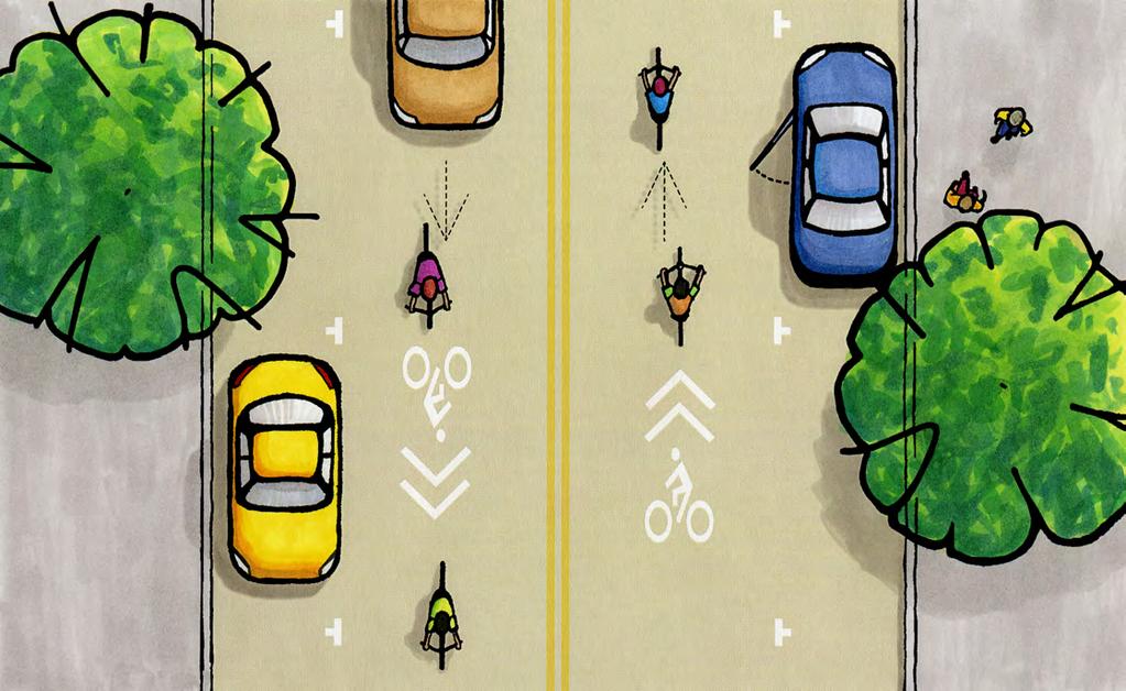
14 E. Shared-Lane Markings ( Sharrows ) A Shared-Lane Marking or sharrow can be used to indicate a narrow shared lane, where motorists have to leave the lane to pass a person on a bicycle. Sharrows highlight bicyclists right to ride in the travel lane, away from hazards such as the door zone of parked vehicles. Bicyclists must obey signs and signals, just like other vehicles. Location Bicycle riders may comfortably share lanes with motor vehicles on hamlet, village and city streets with average speeds below 30 mph, and on rural roads with fewer than 1,000 vehicles/day and speeds below 50 mph. Design streets in hamlets, villages and cities for speeds below 30 mph to safely accommodate people on bicycles. By law, bicyclists may use the full lane if needed to avoid debris, bad pavement, parked vehicles, other obstacles, or to make a left turn. Spacing: Place sharrows at regular intervals approximately 250 feet apart, as well as immediately before and after intersections and at conflict points. Signage: o Supplement sharrows with a Narrow Lane assembly consisting of the Bicycle warning sign and an In Lane plaque to alert motorists to the presence of bicycles in the travel lane. o The Narrow Lane assembly can be used on any street with narrow lanes where side-by-side travel of vehicles and bicycles within the lane is not possible. o Any shared street can be supplemented with Bicycle warning signs to alert motorists to the presence of people on bicycles. Sharrows are appropriate on streets with speed limits up to 35 mph and no shoulders (or inadequate shoulders). They are typically used on narrow lanes, defined by NYSDOT as lanes with less than 14 feet of usable width or less than 26 feet of usable width with a marked on-street parallel parking lane. Design 9 Placement: Place sharrows in the center of the effective lane. If there is no on-street parking, this is the center of the actual lane. If there is on-street parking, this is the lane width between the door zone and 1.5 feet from the left edge of the lane. 9 NYSDOT Shared-Lane Markings (SLMs) Policy, 12/31/2012. Sharrows remind drivers and bicyclists that bicycles may use the full travel lane (source: clrp.cornell.edu). The Narrow Lane assembly can be used on any street with narrow lanes (source: NYSDOT). 45


15 46

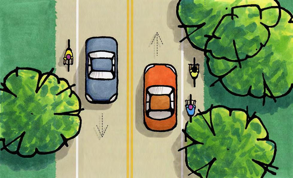
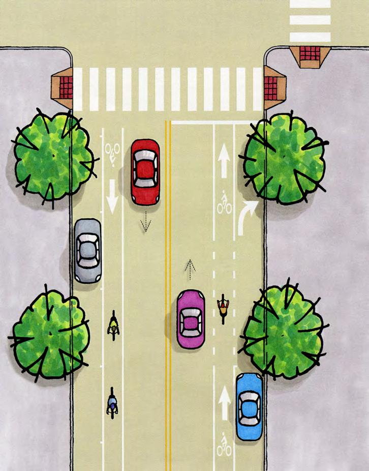
16 F. Bicycle Lanes Bicycle lanes provide a dedicated on-street space for bicycling. People on bicycles ride in the same direction as adjacent traffic and must obey signs and signals, just like other vehicles. New York State s Vehicle and Traffic law states that when a usable bicycle lane exists, bicyclists shall ride in the bike lane, but they may use the travel lane if needed to avoid debris, bad pavement, parked vehicles, other obstacles, to pass other bicyclists, or to make a turn. Location 10 Bicycle lanes are useful on village, city, or suburban streets where people on bicycles travel at significantly different speeds than other traffic, especially streets with speeds over 30 mph or more than 10,000 vehicles per day. On two-way streets, provide bicycle lanes on both sides of the street. On streets with a substantial grade, a bike lane could be provided in the uphill direction (where bicyclists speeds are significantly slower than vehicles) and sharrows provided in the downhill direction (where bicyclists speeds are more similar to vehicles). On one-way streets, the bicycle lane is typically on the right side only, unless a left-side bike lane reduces conflicts (such as a street with heavy right turns, on-street parking, deliveries, etc.). 10 Dutchess County Department of Planning & Development; Greenway Guide D5: Building Bicycle Networks; AASHTO Guide for the Development of Bicycle Facilities, Typical bike lane pavement markings (source: AASHTO 2012). 47

.")
17 Avoid marking bicycle lanes adjacent to front-in angled parking, since drivers backing out will have limited visibility of people on bicycles. Bike lanes may be used adjacent to back-in angled parking. Design 11 Width: Typically four feet minimum if there is no curb or onstreet parking; five feet minimum if there is a curb or on-street parking; and six feet or wider if there are more than 30 trucks or buses per hour or speeds over 45 mph. Marking: Separate the bike lane from the adjacent lane with a stripe, or a two to three foot painted buffer (creating a buffered bicycle lane). Mark with a bicycle symbol after each intersection. Additional markings may be used on intersection approaches and as needed. Protected Bike Lanes: A bike lane can be protected by a physical barrier such as bollards, planters, parking, or a curb. Physically-separated bike lanes are called protected bike lanes or sometimes cycle tracks. Signs: Bike Lane signs may be used to supplement pavement markings. Color: Green-colored pavement can be used to highlight the bicycle lane and/or its extension through intersections. Design intersections carefully to accommodate turns. Typically, bike lane lines are not extended through an intersection. In complex intersections, bike lane lines may be dashed through the intersection. o Approaching intersections without a right-turn-only lane, the bike lane lines can be dashed to indicate the potential for turns across the bike lane. o Approaching intersections with a right-turn-only lane, place the bike lane to the left of the right-turn-only lane. Dash the bike lane lines through the merge area and continue with solid lines before the intersection. Signs can be used to remind merging motorists to yield to people on bicycles. o If a through lane becomes a right-turn-only lane, drop the bike lane and re-introduce it to the left of the rightturn-only lane. In this case, people on bicycles merge across the travel lane and must yield to motorists. o Bicyclists may turn left by merging left and turning with motor vehicles, or by proceeding straight, stopping at the far side corner of the intersection, and crossing with cross-traffic on the right side of the lane (or as a pedestrian in the crosswalk). 11 Ibid. Bicycle lanes can be protected from motor vehicle traffic with parking, bollards, planters, or curbs (sources: BikeAroundBend.com; ResetSanFrancisco.org). 48


18 o A bicycle left-turn lane can be used to accommodate high volumes of left-turning bicycles. A bicycle left-turn lane would be placed to the right of a left-turn-only lane. o Bicycle lanes are terminated before roundabouts. People on bicycles may use the roundabout as a vehicle, or cross in crosswalks as a pedestrian. Ramps may be provided at complex roundabouts to allow people on bicycles to access an adjacent sidewalk or path. o A Bike Box provides space for bicyclists to wait in front of motor vehicles at a red light. They make people on bicycles more visible and prevent them from being cut off by right-turning drivers. They are often colored green for visibility. What About Wide Curb Lanes? In the past, wide curb lanes of 14 feet were recommended to accommodate both motor vehicles and bicycles. However, wide lanes often encourage higher speeds, which decrease safety. On higher-volume and/or higher-speed streets, bicycle lanes or paved shoulders are preferred, based on the guidance outlined above. What is a Bike Route? Bike routes are signed routes on shared streets. Signed bike routes are typically used to direct people on bicycles to preferred streets based on continuity, access to destinations, traffic volume, shoulder width, or other features. However, a bike route does not necessarily have standard features. It is considered a designation, not a facility type. Bike boxes reduce conflicts between turning vehicles and bicyclists at intersections (sources: Bloomington.In.Gov; NACTO.org). 49
19 50
, low-volume (less than 3,000 vehicles/day) residential streets parallel to a major street.")

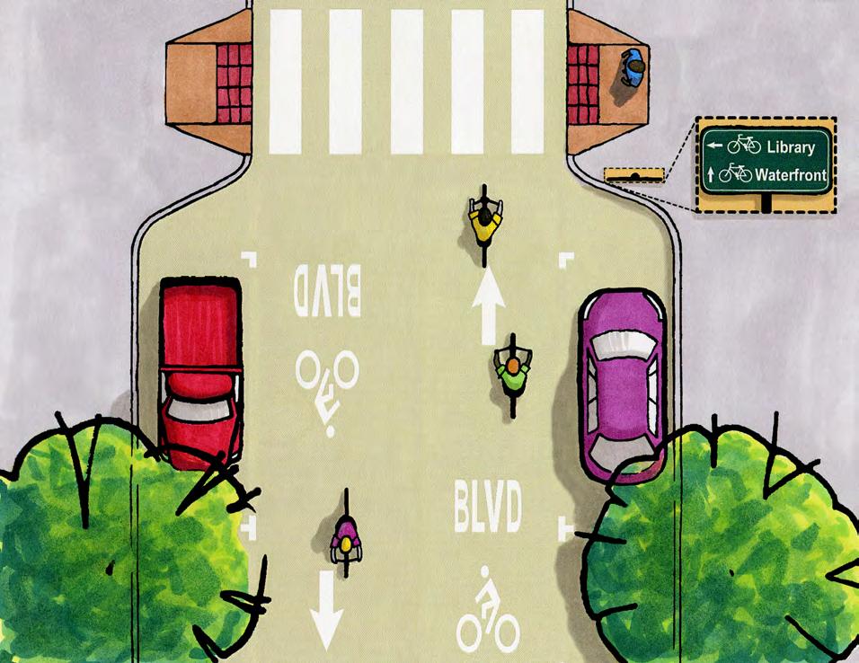
20 G. Bicycle Boulevards Bicycle Boulevards are bicycle-priority streets, shared with lowspeed, local traffic. As on all streets, bicyclists must obey signs and signals, just like other vehicles. Location 12 Bicycle Boulevards are typically low-speed (25 mph or slower), low-volume (less than 3,000 vehicles/day) residential streets parallel to a major street. Bicycle Boulevards work best when they are part of a network, connecting people to destinations while avoiding traffic on major streets. Design Identify a bicycle boulevard with distinctive signs and pavement markings. Pavement markings clearly indicate a Bicycle Boulevard (source: ci.berkeley.ca.us) Reduce vehicle speeds and cut-through traffic with traffic calming treatments such as traffic diverters, neighborhood traffic circles, chokers (or neckdowns ), and others. Prioritize bicycle travel by limiting the use of stop signs on the Bicycle Boulevard. Reorient stop signs to stop cross-traffic instead of the Bicycle Boulevard where feasible. 12 Ibid. Directional signs guide bicyclists to nearby destinations (source: Streetsblog.org). 51
21 52


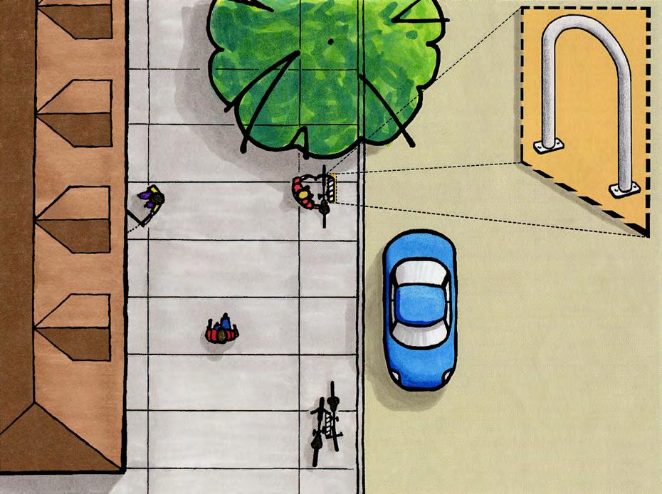
22 H. Bicycle Parking Bicycle parking is critical, since people are much more likely to ride to a destination if there is a convenient, secure place to lock their bike. There are two main types of bike parking: short-term and long-term. Best practice bicycle parking codes are provided in Appendix B. Location Provide short-term parking at public facilities, shops, restaurants, parks, and other destinations where bikes will be parked for up to two hours. Provide long-term parking at offices, housing complexes, transit stations, schools, and other destinations where the bike will be parked for more than two hours. Provide signs to direct bicyclists to parking. Design 13 Inverted U bicycle racks are recommended for short-term parking. A cross-bar can be added for additional security. parking, place them near the ends of the parking spaces so they do not interfere with people getting in and out of cars. o When perpendicular to a building wall, place racks at least four feet from the wall to allow the frame and at least one wheel to be locked securely to the rack. o When parallel to a building wall, place racks at least three feet from the wall. o When aligned side by side, place racks at least three feet from each other. o When aligned end-to-end, place racks at least eight feet apart. o When parallel to a curb, place racks at least two feet from the back of the curb. o When perpendicular to a curb, place racks at least three feet from the back of the curb. Locate the racks in a convenient, visible location as close to the building entrance as practical. Racks can be covered to provide protection from weather. Ensure that bicycle parking does not restrict access for people on sidewalks or near building entrances. If the racks are adjacent to on-street parallel 13 AASHTO Guide for the Development of Bicycle Facilities, Short term bike racks provide convenient access to a restaurant in Poughkeepsie; a bike cage is secure and protects bikes from weather (right photo source: treadly.net). 53


23 Features of a good bicycle rack include: o Stable structure and permanent foundation that is securely anchored in the ground. o Supports the bicycle at two points above its center of gravity. o Design that prevents the bicycle from tipping over. o Ability to support a variety of bicycle sizes and frame shapes. o Accommodates high-security U-shaped bike locks. o Space to secure the frame and one or both wheels to the rack. o Keeps bicycle wheels on the ground. o Contains no sharp edges or protruding elements. A secure, sheltered facility is best for long-term parking. At a minimum, this could be a covered bike rack area. Where possible, provide an enclosed, locked or monitored facility, such as a bicycle cage, bicycle lockers, or a bicycle room (such as in a parking garage). These areas should be well-lit and easy to find. What about Bike Sharing? Bike sharing programs are spreading rapidly across many cities. They allow low-cost, short-term use of public bicycles for a variety of trips. Recent systems include automated kiosks and electronic tracking of the bicycles. The most successful programs have many stations; are supported by an extensive network of bicycle lanes, paths, and bike parking; and incorporate substantial marketing and education for bicyclists and motorists on how to safely share the road. Bicycle corrals provide on-street bike parking, typically in a converted parking space protected by curbing, bollards, planters or other structures (sources: nyc.gov; BostonBikes.org). 54
24 55


25 I. Traffic Calming By itself, lowering a speed limit is unlikely to reduce speeding. Drivers generally base their speed on what feels comfortable or safe given the design of the street. The width of the lanes, horizontal and vertical curvature, shoulder width, and presence of buildings, street trees, and sidewalks affect speeds much more than speed limit signs. Changing the street s characteristics to narrow the perceived width can change drivers perception of a safe speed and help reduce speeding. Street design and traffic calming elements can be used to slow speeds to under 30 mph in centers and under 20 mph in areas with substantial walking activity. Consider specific treatments on a case-by-case basis, balancing the needs of all road users. Narrow lanes: In centers with lower speed limits and a low volume of trucks and buses, ten foot lanes are often sufficient. Eleven foot lanes can be used where there are more trucks and buses. A road diet on Raymond Avenue in the Town of Poughkeepsie reduced the travel lanes from four to two and added a paved/landscaped median, roundabouts, curb extensions, and high-visibility crosswalks with median refuges, slowing speeds and increasing safety (bottom photo source: NYSDOT). On-street parking: The friction of vehicles entering and exiting parking spaces and people getting in and out of vehicles reduces speeds. On-street parking also provides a buffer between people on the sidewalk and moving traffic. Street trees: A consistent line of trees gives a street a sense of enclosure, reducing travel speeds. Trees also increase comfort for people walking. Street trees are most effective when placed between the sidewalk and the street. Consider spacing trees 20 to 30 feet apart in centers and 30 to 40 feet apart on higher-speed roads. 14 Ensure that trees do not obstruct visibility for vehicles entering the street or people entering a crosswalk. Continuous storefronts: Streets with buildings set close to the sidewalk and parking at the side or rear of the lot provide a sense of enclosure and tend to reduce speeds. 14 Dutchess County Department of Planning & Development; Greenway Guide E5: Street Trees 56

26 Road Diets: Road diets involve reducing the number and/or width of travel lanes to slow speeds and provide space for other elements. A typical road diet converts a four lane street into two through lanes with center left turn pockets and bicycle lanes. Wider sidewalks, a landscaped buffer, a raised median, or on-street parking could also be added. Curb Extensions: Extending the curb at an intersection or midblock crossing shortens the distance a person has to cross, makes pedestrians and drivers more visible to each other, and narrows the street, slowing speeds. Curb extensions can also provide space for a bus stop, signs and street furniture. Curb extensions are only feasible where there is on-street parking. They should not extend into the travel lane or shoulder. Raised Crosswalks or Intersections: Creating a raised crosswalk or raised intersection slows approaching vehicles and enhances the crossing(s), encouraging drivers to yield to people crossing. They are best used in areas with consistent walking activity. Neighborhood traffic circles: Installing mini-traffic circles at intersections on low-volume residential streets can reduce speeds substantially. They also increase safety by eliminating left turns (drivers making a left turn drive around the circle). Stop signs are not needed; all traffic yields to traffic in the circle. Raised medians: A raised median visually narrows the street, particularly if it is landscaped, such as with street trees. At crossings, a median can serve as a refuge island for people crossing, if it is at least six feet wide. Raised medians are especially useful on high-volume multi-lane streets. They can also serve as a gateway to a hamlet, village, or Town center, often in combination with curb extensions, landscaping, and other features. Pavement markings: A painted stripe, hatching pattern, or colored pavement can visually narrow the lane and reduce speeds. Roundabouts: Modern roundabouts are designed to slow speeds and minimize conflicts at intersections, while reducing delay compared to stop signs or signals. Drivers yield to circulating traffic. The location and design of roundabouts must carefully consider access by foot and on bicycles, with particular sensitivity to the elderly, children, and persons with certain disabilities. Single-lane roundabouts are greatly preferred; if multiple lanes are expected to be needed, the roundabout could be designed to be expanded in the future. Locate crosswalks to minimize the crossing distance. See Section F above regarding bicycle lanes at roundabouts. Simple pavement markings in the Town of Poughkeepsie help slow speeds (source: Google maps). 57


27 ' '
.")


28 J. Street Amenities Amenities such as lighting, landscaping, and street furniture add comfort and beauty to a street. Pedestrian-scale lighting: Lighting in walkable areas should be 10 to 15 feet tall and spaced approximately four times the height (e.g., 40 to 60 feet). Use fixtures that direct light downwards and include full shielding to reduce glare and sky glow. 15 Landscaping: A landscaped buffer with grass, plantings or street trees between the sidewalk and street increases comfort for people walking and makes the street more attractive. Planters, hanging flower baskets, and other landscaping can also be effective. When planning landscaping, ensure adequate sight distance for vehicles entering the street and people entering a crosswalk. Planters, benches, and other amenities in the Village of Rhinebeck create a welcoming, comfortable streetscape. Street Furniture: Bus stop shelters (with seating), benches, bicycle parking racks, water fountains, newspaper racks, and trash cans add to a comfortable and attractive street. Place elements carefully to avoid blocking the sidewalk or reducing visibility. What is a Stair Channel? Stair channels, sometimes called bicycle ramps, are narrow channels along the side or center of a stairway that allow a bicycle to be rolled up or down the stairs. They can be incorporated into a stairway design or used to retrofit a stairway to accommodate bicycles. However, care must be taken to ensure that handrails along the stairs are still useable, and that the handrails do not prevent use of the stair channel. Stair channels can be integrated into the stair design or added later as a retrofit (sources: StreetsBlog.net; Fred Schaeffer). 15 Dutchess County Department of Planning & Development; Greenway Guide E4: Lighting 59


29 K. Bus Stops In areas with transit service, bus stops are an integral part of the walking environment. Design stops to encourage walking (and bicycling) between the bus stop and nearby destinations. Provide convenient walking access to the bus stop with sidewalks, curb ramps, and crosswalks. Install bus stop shelters or benches and map/schedule kiosks at stops with high ridership and those serving elderly or disabled patrons to increase passengers comfort and protection from weather. Install sheltered bike parking at or near bus stops serving key destinations. Design bus stops so that bus drivers can deploy the wheelchair lift or ramp, preferably directly onto a sidewalk. A bus bulb, which is a curb extension at the bus stop location, allows the bus to easily re-enter traffic and provides space for bus stop shelters and other amenities. Bus bulbs work only on streets with on-street parking. A bus stop in Beacon is accessible by sidewalks and includes a shelter and bench. The Poughkeepsie Transit Hub (bottom) includes shelters, curb ramps, crosswalks, and bicycle parking near the street. 60
30 61

31 L. Traffic Signals Design and operate traffic signals to support access for people on foot and on bicycles. Pedestrian Signal Location: Provide pedestrian signals at all signalized intersections with walking activity. See the MUTCD for guidance. o Fixed-time (non-actuated) pedestrian signals, which provide a walk interval during every signal cycle, are appropriate in areas with consistent walking activity during most of the day. o Actuated pedestrian signals, which require the user to push a button, are appropriate in areas with intermittent walking activity. Pedestrian Signal Design: 16 All pedestrian signals with a clearance interval (Flashing Don t Walk phase) of more than seven seconds should include a countdown timer that shows the number of seconds left to cross. This pedestrian push button is accessible, near the curb ramp, and its face is parallel to the direction of the crosswalk. For actuated pedestrian signals: o Where possible, install each push button on a separate pole adjacent to the appropriate crosswalk. o Place the push button pole on a level, accessible location as close to the curb ramp as possible. o Install the push button so that its face is parallel to the direction of the marked crosswalk. o Place push buttons where they can be easily reached by someone in a wheelchair (typically no higher than 3.5 feet above the sidewalk). Large push-buttons are easiest to use. Accessible pedestrian signals, which provide audible tones, can be installed to assist people with visual impairments. Pedestrian Signal Timing: 17 Keep signal cycles short to reduce wait time for people crossing, including those on bicycles and in vehicles. Time pedestrian signals based on a walking speed of 3.5 feet per second, or 3.0 feet per second if a significant proportion of the people crossing are elderly or mobility-impaired. 16 MUTCD, 2009 Edition, including revisions dated May FHWA, Accessible Sidewalks and Street Crossings- An Informational Guide. FHWA-SA MUTCD, 2009 Edition, including revisions dated May WalkingInfo.org 62


32 Consider the following signal timing features to increase safety for people walking: o A protected left turn phase (allowing only left-turning vehicles to proceed) reduces crashes between leftturning vehicles and people crossing by 90 percent. flashing yellow, then a steady yellow, and then a red light, during which people crossing are given the WALK signal. During the flashing don t walk phase, drivers see a flashing red light, meaning they must stop first and only proceed if the crosswalk is clear. When not activated by a pedestrian, the signal is dark. o A leading pedestrian interval begins the WALK signal at least three seconds before parallel vehicles get a green signal, allowing people to start crossing first, making them more visible to motorists and increasing yielding. This is especially useful where there are two turning lanes. o Prohibiting right turns on red reduces conflicts between right- turning vehicles and people in the crosswalk in front of the vehicle. This is useful at locations or during specific times with significant walking activity and many right-turn conflicts. o An exclusive pedestrian phase lets people to cross in any crosswalk while all vehicles have a red signal. This can be helpful at intersections with very high numbers of people crossing and many conflicts with turning vehicles. However, it lengthens the signal cycle, increasing wait time for walkers and vehicles, and may result in people crossing against the signal. A pedestrian scramble, which allows diagonal crossings, must be signed. A pedestrian hybrid beacon or HAWK can be used to assist people crossing at an un-signalized crosswalk, while minimizing delay for vehicles. It is a pedestrian-actuated signal: when a person pushes the pushbutton, drivers see a A HAWK signal provides a protected pedestrian crossing when needed, while minimizing delay. HAWK signals can also incorporate bicycle signals and phases, as in Tucson, AZ (sources: MUTCD; BikeLeague.org). 63
33 Smart signals detect people waiting to cross, trigger the WALK signal, and can extend the crossing time if needed based on the speed of the person detected in the crosswalk. Signal Timing for Bicyclists: 18 At actuated signals, detectors may be able to be adjusted to be sensitive to bicycles, so that a bicycle rider waiting at the signal will receive a green light. At actuated signals that can detect bicycles, a bicycle symbol can be marked on the pavement to show people where to position their bicycle to be detected. traffic begins. A longer all-red interval may be needed. Some signals with bicycle detection can be programmed to provide a longer green extension time when a bicycle is detected. A bicycle signal, exclusively for bicyclists, may be appropriate at path crossings or other high-use bicycle crossings. o Diagonal quadrupole inductive loops have a larger magnetic field than conventional loops and are more sensitive to bicycles. Alternatives such as video, infrared, or radar/microwave detection can be effective at detecting both moving and stopped bicycles, and are more flexible than inductive loops. However, video detection can be affected by lighting and weather conditions. Adjust signal timing as needed so that bicyclists starting at the intersection from a stop can clear the intersection. Consider longer minimum green times at wide crossings and in areas with young people on bicycles, such as near schools. Some signals with bicycle detection can be programmed to provide a longer minimum green when a bicycle is detected. Diagonal quadrupole loop detectors are more effective than conventional loop detectors at detecting bicycles (source: AASHTO 2012). Adjust signal timing as needed so that a person approaching the intersection on a bicycle at the end of the green interval can clear the intersection before the green signal for cross- 18 AASHTO Guide for the Development of Bicycle Facilities,


34 M. Maintenance 19 Consistent maintenance is critical to ensure safe access for people walking and bicycling. Local ordinances often require property owners to maintain adjacent sidewalks and remove snow within a reasonable period. However, sidewalks and other facilities are far more likely to be well-maintained if the municipality or road owner provides this service (see Chapter 4 for best practice local policies). Prioritize maintenance on streets in designated centers and outlying roads with significant bicycle use. Maintain walking and bicycling facilities to be free of debris and have a smooth surface. This requires regular sweeping and surface repairs, as well as vegetation mowing, trimming and root control. Clear snow and ice from sidewalks and road shoulders. Mark crosswalks regularly to ensure visibility and reflectivity. Use durable materials (such as inlay tape or thermoplastic) to reduce maintenance. Extend pavement overlays over the entire roadway, including the full width of the shoulder, to avoid creating an edge. Clearing snow from sidewalks and shoulders and ensuring adequate drainage is critical to maintaining access for walking and bicycling. Limit the use of chip seal, as it creates a rough surface for bicycling. When necessary, use a fine mix chip seal and sweep the roadway afterwards. Notify the public of chip sealing projects ahead of time (via a website or other methods) so people traveling by bicycle can plan detours if needed. Pave unpaved public roads and driveways back from the road (30 feet and 10 feet are recommended, respectively) to prevent gravel from spilling onto the roadway. Design drainage to prevent ponding of water and ice at the base of curb ramps. Clear drainage inlets regularly to prevent build-up of leaves and other materials. Use bicycle-friendly drainage grates, with openings perpendicular to the direction of travel and small enough to prevent a wheel from entering. Minimize gaps between the grate and its frame to one inch or less. Maintain streets such that surface grates and utility covers are flush with the street surface. 19 Ibid. 65
 is responsible for State roads (identified on maps and on the road by a white shield with the State Route number in black) and intersections with State")
35 Who Owns the Streets? The State Department of Transportation (NYSDOT) is responsible for State roads (identified on maps and on the road by a white shield with the State Route number in black) and intersections with State roads. Sidewalks on State roads may be installed by the municipality or property owner (with a permit from NYSDOT), or by NYSDOT as part of a capital project. Typically, sidewalks on State roads are owned by NYSDOT but maintained by the municipality (which often passes this responsibility to the adjacent property owner). The County Department of Public Works (DPW) is responsible for County roads (identified on maps and on the road by a blue shield with the County Road (CR) number in yellow). Sidewalks on County roads may be installed by the municipality or property owner (with a permit from County DPW), or by County DPW. Sidewalks on County roads are maintained by the municipality (which often passes this responsibility to the adjacent property owner). Municipalities are responsible for local streets and sidewalks. Street ownership and maintenance responsibilities should be verified with local agencies as part of any planning process. State roads are identified by a white shield with the State Route number in black. County roads are identified by a blue shield with the County Road number in yellow. 66
36 Additional Guidance Street Design o Greenway Connections and Greenway Guides o NACTO Urban Streets Design Guide o NYS Association of Metropolitan Planning Organizations Fact Sheets Walking Facilities o NYSDOT Highway Design Manual, Chapter 18 o WalkingInfo.org o FHWA Guide for Maintaining Pedestrian Facilities for Enhanced Safety Accessibility o US Access Board Bicycling Facilities o AASHTO Guide for Bicycle Facilities (4th Edition) o NACTO Urban Bikeway Design Guide o NYSDOT Highway Design Manual, Chapter 17 o BicyclingInfo.org Bicycle Parking o APBP Bicycle Parking Guidelines o PDCTC Bicycle Parking guidelines Signs, Signals, and Pavement Markings o Manual on Uniform Traffic Control Devices (MUTCD) o New York State Supplement to the MUTCD o NYSDOT Shared-Lane Marking (SLM) Policy 67
Off-road Trails. Guidance
 Off-road Trails Off-road trails are shared use paths located on an independent alignment that provide two-way travel for people walking, bicycling, and other non-motorized users. Trails specifically along
Active Transportation Facility Glossary
 Active Transportation Facility Glossary This document defines different active transportation facilities and suggests appropriate corridor types. Click on a facility type to jump to its definition. Bike
CURBSIDE ACTIVITY DESIGN
 5 CURBSIDE ACTIVITY DESIGN This chapter provides design guidance for separated bike lanes adjacent to curbside activities including parking, loading and bus stops. Typical configurations are presented
NJDOT Complete Streets Checklist
 Background The New Jersey Department of Transportation s Complete Streets Policy promotes a comprehensive, integrated, connected multi-modal network by providing connections to bicycling and walking trip
APPENDIX A: Complete Streets Checklist DRAFT NOVEMBER 2016
 APPENDIX A: Complete Streets Checklist DRAFT NOVEMBER 2016 Complete Streets Checklist MetroPlan Orlando s Complete Streets Checklist is an internal planning tool for staff to further implementation of
Chapter 5: Crossing the Street
 Chapter 5: Crossing the Street Whether walking or bicycling, a student s journey to school will more than likely require crossing one or more streets. Per the Safe Routes to School Guide, maintained by
Broad Street Bicycle Boulevard Design Guidelines
 Broad Street Bicycle Boulevard Design Guidelines Building from the strategies introduced in the 2013 Bicycle Transportation Plan and community input received thus far, City Transportation Staff have identified
Steps to Conducting a Complete Streets Assessment
 Steps to Conducting a Complete Streets Assessment Familiarize yourself with Complete Streets Read through the Complete Streets Assessment Guidelines. This will give you an idea of what Complete Streets
MEMORANDUM. Date: 9/13/2016. Citywide Crosswalk Policy
 MEMORANDUM Date: 9/13/2016 Re: Citywide Crosswalk Policy Foreword Through the s Circulation Element and Complete Streets Policy, it is the City s goal to promote walking trips and provide safe facilities
On-Street Bicycle Facilities
 On-Street Bicycle Facilities A. General 12B-3 Design Manual Chapter 12 - Sidewalks and Bicycle Facilities 12B - Bicycle Facilities Cyclists have similar access and mobility needs as other transportation
CITY OF SARATOGA SPRINGS PEDESTRIAN CROSSING TOOLBOX
 CITY OF SARATOGA SPRINGS PEDESTRIAN CROSSING TOOLBOX This toolbox is to be used to guide pedestrian crossing improvements within the City of Saratoga Springs. Details for each crossing type are provided.
Appendix 3 Roadway and Bike/Ped Design Standards
 Appendix 3 Roadway and Bike/Ped Design Standards OTO Transportation Plan 2040 4/20/2017 Page A3-1 Adopted Standards The adopted OTO Design Standards and Major Thoroughfare Plan are contained herein.
Appendix T CCMP TRAIL TRAFFIC & TRANSPORTATION DESIGN STANDARD
 Appendix T CCMP 3.3.4 TRAIL TRAFFIC & TRANSPORTATION DESIGN STANDARD 3.3.4 Trail Traffic and Transportation Design Multi-use trails have certain design standards, which vary depending on the agency that
Complete Streets Design Considerations. Second Street Corridor Complete Streets Workshop and Assessment Manchester, NH April 26, 2013
 Complete Streets Design Considerations Second Street Corridor Complete Streets Workshop and Assessment Manchester, NH April 26, 2013 2 nd Street Existing Information Average Annual Daily Traffic Volumes
INDEX. Geometric Design Guide for Canadian Roads INDEX
 Acceleration lane, see Lanes, Acceleration Access, 8.1 Access Management and Functional Classification 8.2 Access Management by Design Classification 8.3 Access Configuration 8.4 Building Set-Back Guidelines
Accommodating Pedestrians in the Work Zone
 Accommodating Pedestrians in the Work Zone Guidance for Section C Plan Preparers Some impacts cannot be avoided and those impacts apply to residents, businesses, motorists, and pedestrians alike. However,
City of Vallejo Traffic Calming Toolbox
 City of Vallejo Traffic Calming Toolbox June 1, 2013 Final Table of Contents Introduction... 1 Non-Physical Devices... 3 High-Visibility Crosswalk... 3 In Pavement Lighted Crosswalk... 4 Rapid Flashing
2014 FHWA Aging Road User Handbook. Recommendations to Accommodate Aging Pedestrians. Lifesaver National Conference. What is the Handbook?
 2014 FHWA Aging Road User Handbook Recommendations to Accommodate Aging Pedestrians Lifesaver National Conference March 17, 2015 Revised June 2014 1 What is the Handbook? 1998 1st Edition 2001 2nd Edition
ADA on Construction. Guidance for Section C Plan Preparers
 ADA on Construction Guidance for Section C Plan Preparers Some impacts cannot be avoided and those impacts apply to residents, businesses, motorists, and pedestrians alike. However, good planning can minimize
Appendix C. TRAFFIC CALMING PROGRAM TOOLBOX
 Appendix C. TRAFFIC CALMING PROGRAM TOOLBOX PHASE I...2 Do Not Enter Sign...3 One-Way Sign...4 Turn Prohibition...5 Pavement Markings...6 Speed Monitoring Trailer...7 Neighborhood Speed Watch...8 Police
What Is a Complete Street?
 Session 5 Charleen Zimmer, AICP, Zan Associates May 5-7, 2010 What Is a Complete Street? May 2010 5-1 Not a Complete Street More of a Complete Street May 2010 5-2 Benefits of Complete Streets Safety for
SRTS IMPLEMENTATION COSTS
 SRTS IMPLEMENTATION COSTS What Is a Estimate? A cost estimate establishes the anticipated budget required to implement the actions (the improvement projects and programs) identified in your School Travel
REGIONAL BICYCLE AND PEDESTRIAN DESIGN GUIDELINES
 REGIONAL BICYCLE AND PEDESTRIAN DESIGN GUIDELINES November 16, 2011 Deb Humphreys North Central Texas Council of Governments Bicycle and Pedestrian Advisory Committee Snapshot of the Guide 1. Introduction
7/23/2017 VIA . Michael Hanebutt City of Sacramento Community Development Department 300 Richards Boulevard, 3 rd Floor Sacramento, CA 95811
 7/23/2017 VIA EMAIL Michael Hanebutt City of Sacramento Community Development Department 300 Richards Boulevard, 3 rd Floor Sacramento, CA 95811 RE: 65 th Street Apartments (DR17-220) Dear Mr. Hanebutt:
Standards vs. Guidelines. Public Right-of Way Accessibility Guidelines (PROWAG)
") www.access-board.gov Public Right-of Way Accessibility Guidelines (PROWAG) Juliet Shoultz, P.E Transportation Systems Engineer US Access Board Standards vs. Guidelines Guidelines are developed by the Access
www.access-board.gov Public Right-of Way Accessibility Guidelines (PROWAG) Juliet Shoultz, P.E Transportation Systems Engineer US Access Board Standards vs. Guidelines Guidelines are developed by the Access
Cycle Track Design Best Practices Cycle Track Sections
 Design Best Practices Sections It is along street segments where the separation and protection methods of cycle tracks offer more comfort than conventional bicycle lanes, and are more attractive to a wide
The 2012 AASHTO Bike Guide: An Overview
 The 2012 AASHTO Bike Guide: An Overview Presentation by: Jennifer Toole, AICP, ASLA Peter Lagerwey August 10, 2012 {Enter Module Name on Master Slide} WEBINAR #1: OVERVIEW OF 2012 AASHTO BIKE GUIDE Today
Chapter 6: Along the Street
 Chapter 6: Along the Street This section describes the types of infrastructure that should be in place along school routes to make walking and bicycling to school safer. Sidewalks In communities with sidewalks,
March 2008 FINAL DRAFT. Supplemental Bikeway Design Guidelines
 March 2008 FINAL DRAFT Supplemental Bikeway Design Guidelines Prepared for: Marin County Department of Public Works Marin County Unincorporated Area Bicycle and Pedestrian Master Plan Prepared by: Alta
DRAFT Montgomery County Bicycle Master Plan Design Toolkit
 DRAFT Montgomery County Bicycle Master Plan Design Toolkit Fall 2016 Sidepaths Sidepaths are shared use paths located parallel to and within the road right-of-way providing twoway travel for walking, bicycling,
ROUNDABOUTS/TRAFFIC CIRCLES
 GENERAL 1. Description This standard identifies minimum requirements that shall be met for Roundabouts and Neighborhood Traffic Circles in the design and construction of elements for Arlington County Horizontal
C/CAG. Sunnybrae Elementary School Walking and Bicycling Audit. San Mateo-Foster City School District JUNE 2013
 Sunnybrae Elementary School Walking and Bicycling Audit JUNE 2013 San Mateo-Foster City School District C/CAG City/County Association of Governments of San Mateo County SUNNYBRAE ELEMENTARY SCHOOL WALKING
On Road Bikeways Part 1: Bicycle Lane Design
 On Road Bikeways Part 1: Bicycle Lane Design Presentation by: Nick Jackson Bill Schultheiss, P.E. September 04, 2012 FOLLOW THE CONVERSATION ON TWITTER Toole Design Group is live tweeting this webinar
A. Pedestrian Facility Design
 A. Pedestrian Facility Design Photo by Dan Burden Photo by Cara Seiderman Walkways are the portion of the public right-of-way that provide a separated area for people traveling on foot.walkways that are
DRAFT FOR DISCUSSION PURPOSED ONLY, 10/26/13 MOBILITY PLAN UPDATE DESIGN TOOLBOX
 DRAFT FOR DISCUSSION PURPOSED ONLY, 10/26/13 MOBILITY PLAN UPDATE DESIGN TOOLBOX Tool #1: Bike Lane Portion of the roadway designated for preferential use by bicyclists. One-way facilities that typically
Agenda. Overview PRINCE GEORGE S PLAZA METRO AREA PEDESTRIAN PLAN
 PRINCE GEORGE S PLAZA METRO AREA PEDESTRIAN PLAN May 28, 2008 Agenda Welcome and introductions Project overview and issue identification Planning context and strengths Design challenges and initial recommendations
Walk Friendly Communities Engineering Strategies. Carl Sundstrom Walk Friendly Communities Workshop Grandview, MO June 2015
 Walk Friendly Communities Carl Sundstrom Walk Friendly Communities Workshop Grandview, MO June 2015 Module Overview Topics Background and purpose Sidewalks Crossings Traffic calming www.pedbikeimages.org
INDOT Complete Streets Guideline & Policy
 INDOT Complete Streets Guideline & Policy INTRODUCTION The Complete Streets guidelines build upon multiple efforts and promote a multimodal transportation system that is integrated and sustains land use
City of Albert Lea Policy and Procedure Manual 4.10 ALBERT LEA CROSSWALK POLICY
 4.10 ALBERT LEA CROSSWALK POLICY PURPOSE: Pedestrian crosswalks are an integral part of our transportation infrastructure. To be effective and promote safety, marked crosswalks must be installed after
Omaha s Complete Streets Policy
 Omaha s Complete Streets Policy (Adopted August 2015) VISION To create great places and enhance our quality of life, the City of Omaha will provide safe, accessible streets for all users. Complete Streets
CHAPTER 16 PEDESTRIAN FACILITIES DESIGN AND TECHNICAL CRITERIA TABLE OF CONTENTS
 CHAPTER 16 PEDESTRIAN FACILITIES DESIGN AND TECHNICAL CRITERIA TABLE OF CONTENTS Section Title Page 16.1 General... 16-1 16.1.1 AASHTO Reference... 16-1 16.1.2 ADA Requirements... 16-1 16.2 Sidewalks...
DISTRIBUTION: Electronic Recipients List TRANSMITTAL LETTER NO. (17-01) MINNESOTA DEPARTMENT OF TRANSPORTATION. MANUAL: Road Design English Manual
 MINNESOTA DEPARTMENT OF TRANSPORTATION. MANUAL: Road Design English Manual") DISTRIBUTION: Electronic Recipients List MINNESOTA DEPARTMENT OF TRANSPORTATION DEVELOPED BY: Design Standards Unit ISSUED BY: Office of Project Management and Technical Support TRANSMITTAL LETTER NO.
DISTRIBUTION: Electronic Recipients List MINNESOTA DEPARTMENT OF TRANSPORTATION DEVELOPED BY: Design Standards Unit ISSUED BY: Office of Project Management and Technical Support TRANSMITTAL LETTER NO.
Field guide for Accessible Public Rights-of-Way Edition
 Field guide for Accessible Public Rights-of-Way 2015 Edition BRIEFING MEMO SUBJECT: Department of Justice/Department of Transportation Joint Technical Assistance on Title II of the Americans with Disabilities
Town of Mooresville, North Carolina Neighborhood Traffic Calming and Control Device Policy
 Town of Mooresville, North Carolina Neighborhood Traffic Calming and Control Device Policy Adopted January 6, 2014 Town of Mooresville Development Services Department TOWN OF MOORESVILLE NEIGHBORHOOD TRAFFIC
PEDESTRIAN ACCOMMODATIONS DPS 201 AT ROUNDABOUTS
 PEDESTRIAN ACCOMMODATIONS DPS 201 AT ROUNDABOUTS WHY THEY WORK FOR PEDESTRIANS IF DESIGNED CORRECTLY Separated sidewalks direct peds to crosswalks Splitter island Slow speed exit Truck apron Crosswalk
Guidance. ATTACHMENT F: Draft Additional Pages for Bicycle Facility Design Toolkit Separated Bike Lanes: Two-Way to One-Way Transitions
 ATTACHMENT F: Draft Additional Pages for Bicycle Facility Design Toolkit Separated Bike Lanes: Two-Way to One-Way Transitions This treatment provides a transition from two-way separated bike lanes to one-way
Bicycle Facilities Planning
 Bicycle Facilities Planning Overview Types of Cyclists Purpose for Riding Types of Facilities Bike Lanes Bicycle Boulevards Cycle Tracks Intersections Signals Signing and Marking Discussion Types of Bicyclists
Toole Design Group is live tweeting this webinar
 On Road Bikeways Part I1: Non-Bike Lane Design Presentation by: Bill Schultheiss, P.E. Tina Fink, P.E. September18, 2012 FOLLOW THE CONVERSATION ON TWITTER Toole Design Group is live tweeting this webinar
C. Best Practice Pedestrian Treatment Toolbox
 C. Best Practice Pedestrian Toolbox The Best Practice Pedestrian Toolbox presents the recommended tools in striping, signalization, signage, geometry and other categories for improving both uncontrolled
City of Roseville Section 13 Design Standards. _Bikeways January 2016 SECTION 13 BIKEWAYS
 SECTION 13 BIKEWAYS 13-1 GENERAL The City of Roseville bikeway standards are designed to insure that transportation and recreational bikeways are constructed in a manner that would provide a safe and comfortable
Tonight is for you. Learn everything you can. Share all your ideas.
 Strathcona Neighbourhood Renewal Draft Concept Design Tonight is for you. Learn everything you can. Share all your ideas. What is Neighbourhood Renewal? Creating a design with you for your neighbourhood.
CURB EXTENSIONS BULB OUTS DPS 201 NECKDOWNS
 CURB EXTENSIONS BULB OUTS DPS 201 NECKDOWNS WHY WHEN & WHERE When Limited Sight Distance Pedestrians & Vehicles Vehicles and Signs Want to put two curb ramps in Discourage High speed turning High number
G AT E WAY PLAN. Community BRIEFING KIT GATEWAY BIKE
 G AT E WAY PLAN GATEWAY BIKE Community BRIEFING KIT PLAN August 2016 TABLE OF CONTENTS INTRODUCTION... 1 THE BENEFITS OF A BIKEABLE COMMUNITY... 2 ECONOMY...2 SAFETY...3 HEALTH...3 HOUSEHOLD SPENDING...3
PEDESTRIAN CROSSING TREATMENTS
 PEDESTRIAN CROSSING TREATMENTS BEST PRACTICES Presented by: Doug Enderson, P.E., PTOE Cody Salo, P.E. 1 PRESENTER INTRODUCTIONS Doug Enderson, P.E., PTOE Ped Crossing Experience: ADA Design-Build ADA Inventory
ADA & Public Rights of Way
 ADA & Public Rights of Way Overview of Current and Up-coming Requirements FDOT Design Training Expo 2012 Orlando, FL Dean Perkins, RA - ADA Coordinator Florida Department of Transportation Office of Design,
Appendix A: Crosswalk Policy
 Appendix A: Crosswalk Policy Appendix A: Crosswalk Policy Introduction This citywide Crosswalk Policy is aimed at improving pedestrian safety and enhancing pedestrian mobility by providing a framework
8. Design Guidelines for Consideration
 8. Design Guidelines for Consideration ADOT and other implementing agencies within Arizona should consider the appropriate accommodation of bicyclists and pedestrians in planning and construction projects.
Designing for Pedestrian Safety
 Designing for Pedestrian Safety Treatments at Unsignalized Pedestrian Crossings Presented by: Charlie Zegeer PBIC Director August 17, 2010 Crossing Crashes Part 1: General Principles 3 2 Why do people
California Manual on Uniform Traffic Control Devices
 California Manual on Uniform Traffic Control Devices FHWA s MUTCD 2009 Edition as amended for use in California 2012 Edition State of California Business, Transportation and Housing Agency Department of
Pedestrians and Bicyclists. Bruce Friedman and Scott Wainwright FHWA MUTCD Team
 Impact of the New MUTCD on Pedestrians and Bicyclists Bruce Friedman and Scott Wainwright FHWA MUTCD Team Development of the 2009 MUTCD NPA published in the Federal Register on January 2, 2008 Received
CHAPTER 1 STANDARD PRACTICES
 CHAPTER 1 STANDARD PRACTICES OBJECTIVES 1) Functions and Limitations 2) Standardization of Application 3) Materials 4) Colors 5) Widths and Patterns of Longitudinal Pavement Marking Lines 6) General Principles
Designing Pedestrian Facilities for Accessibility. Module 3 Curb Ramps & Blended Transitions
 Module 3 & Other Purpose: Allow pedestrians to transition between the street and sidewalks, islands, etc. Typically installed at: Intersections (1 ramp at each end of each crosswalk) Mid-block crossings
Morristown, NJ Complete Streets Policy
 Morristown, NJ Complete Streets Policy Introduction A Complete Street is defined as a means to provide safe access for all users by designing and operating a comprehensive, integrated, connected multi-modal
Complete Streets. Designing Streets for Everyone. Sarnia
 Complete Streets Designing Streets for Everyone Sarnia Complete Streets ~ Sarnia ~ 2018 Introduction Our City is made up of a network of streets that we use to go for a walk, cycle to work, drive to the
Bowman-Melton Associates, Inc. june 2011
 2011 dallas bike plan ADDENDUM Bowman-Melton Associates, Inc. Complete Streets Initiative Design and policy guidance june 2011 2 2011 Dallas Bike Plan Complete Streets Initiative Design and Policy Guidance
Field guide for Accessible Public Rights-of-Way Edition
 Field guide for Accessible Public Rights-of-Way 2017 Edition CONTENTS PEDESTRIAN FACILITIES IN THE PUBLIC RIGHT-OF-WAY Pedestrian access routes 3 Components 3 Continuous width 3 Median and pedestrian refuge
Chapter 3 DESIGN SPECIFICATIONS
 Brampton PathWays Planning and Design Guidelines 27 Chapter 3 DESIGN SPECIFICATIONS 3.1 CLASS 1 MULTI-USE PATH Off-road multi-use trails are the backbone of the Brampton PathWays Network. They are typically
12/4/2016 VIA . RE: Grocery Outlet Del Paso (DR16-328)
") 12/4/2016 VIA EMAIL Ethan Meltzer, Assistant Planner City of Sacramento Community Development Department 300 Richards Blvd, 3 rd Floor Sacramento, CA 95811 RE: Grocery Outlet Del Paso (DR16-328) Dear Mr.
12/4/2016 VIA EMAIL Ethan Meltzer, Assistant Planner City of Sacramento Community Development Department 300 Richards Blvd, 3 rd Floor Sacramento, CA 95811 RE: Grocery Outlet Del Paso (DR16-328) Dear Mr.
Pedestrian and Bicycle Design Guidelines
 REGIONAL BICYCLE AND PEDESTRIAN STUDY A Strategic Vision for Walking and Bicycling in the Greater Nashville Region Pedestrian and Bicycle Design Guidelines Technical Memorandum 8 November 2009 TABLE OF
5. RUNNINGWAY GUIDELINES
 5. RUNNINGWAY GUIDELINES These guidelines should be considered collectively when making runningway decisions. A runningway is the linear component of the transit system that forms the right-of-way reserved
Chapter 2: Standards for Access, Non-Motorized, and Transit
 Standards for Access, Non-Motorized, and Transit Chapter 2: Standards for Access, Non-Motorized, and Transit The Washtenaw County Access Management Plan was developed based on the analysis of existing
General Design Factors
 Chapter 3: 3-1.0 Introduction General Design Factors Mn/DOT s goals include encouraging and accommodating safe bicycling. From a design perspective, these goals are achieved by first having an understanding
2012 by the American Association of State Highway and Transportation Officials. All rights reserved. Duplication is a violation of applicable law.
 Table of Contents Chapter 1: Introduction... 1-1 1.1 Design Imperative... 1-1 1.2 Purpose... 1-1 1.3 Scope... 1-2 1.4 Definitions... 1-2 Chapter 2: Bicycle Planning... 2-1 2.1 Background... 2-1 2.2 Why
Bicycle Boulevards and Neighborhood Greenways
 Bicycle Boulevards and Neighborhood Greenways Traffic Safety is Improving for Everyone 90 80 70 60 50 40 30 20 10 0 PORTLAND: TOTAL TRAFFIC FATALITIES 1986-2008 1986 1987 1988 1989 1990 1991 1992 1993
Chapter 4 On-Road Bikeways
 Chapter 4: 4-1.0 Introduction On-Road Bikeways This chapter provides guidelines to help select and design safe on-road bikeways. On-road bikeways include bicycle lanes, shared lanes, shoulders, and wide
GLOSSARY CROSSWALK. CROSSING TYPES
 CROSSWALK The part of a roadway at an intersection included within the connections of the lateral lines of the sidewalks on opposite sides of the street measured from the curbs, or in the absence of curbs
Chapter 4 TOOLBOX AND SAMPLE BIKE BOULEVARD LAYOUT
 Chapter 4 TOOLBOX AND SAMPLE BIKE BOULEVARD LAYOUT OVERVIEW This chapter describes a cohesive set of strategies to create a bicycle boulevard, namely to make streets safer and more efficient for bicycle
Aurora Urban Street Standards For Transit Oriented Developments and Urban Centers
 Aurora Urban Street Standards For Transit Oriented Developments and Urban Centers I. Purpose These standards will be applied to create a safe, comfortable, pleasant and pedestrian-friendly multi-modal
3.1 TRAFFIC CALMING PROCESS SUMMARY
 SECTION 3 3.0 TRAFFIC CALMING 3.1 TRAFFIC CALMING PROCESS SUMMARY Traffic calming is a means in which to reduce speeds and minimize vehicular traffic on local neighborhood streets. Citizen involvement
Report. Typical Sections. City of Middleton, WI
 Report Typical Sections City of Middleton, WI December 2006 Report for City of Middleton, Wisconsin Typical Sections repared by: Traffic Associates LLC and STRAND ASSOCIATES, INC. 910 West Wingra Drive
Item to be Addressed Checklist Consideration YES NO N/A Required Description Complete Streets Guidelines
 Passaic County Complete Streets Checklist - Concept Development Project Name Item to be Addressed Checklist Consideration YES NO N/A Required Description Complete Streets Guidelines Existing Plans Have
Design Overview. Section 4 Standard Plans for Design. Pedestrian Access Routes. Pedestrian Access Routes. Overview. Cross Slope
 Design Overview Section 4 Standard Plans for Design Fall, 2017 Ann Johnson, PE Services Brady Rutman, SRF Consulting Group Overview Design Basics Recommendations: The Zone System Driveway Crossings Pedestrian
Appendix C. City of Fort Collins Recommended Bicycle Design Guidelines. Appendix C: Recommended Bicycle Design Guidelines 1
 Appendix C City of Fort Collins Recommended Bicycle Design Guidelines Appendix C: Recommended Bicycle Design Guidelines 1 This appendix provides general design considerations for implementation of bicycle
Who is Toole Design Group?
 2018 AASHTO Bike Guide Status Update NCHRP 15 60 Amalia Leighton Cody, PE, AICP & Kenneth Loen, PE Washington APWA October 4, 2018 Who is Toole Design Group? TDG is a full service engineering, planning
Bicycle and Pedestrian Facilities Toolbox (Excerpt from Figure 3.1)
") Appendix B Neighborhood Connections Summaries This Appendix is a supplement to the information presented in Chapter 3 Connect People. The Appendix includes a summary or profile for each of the proposed
Appendix B Neighborhood Connections Summaries This Appendix is a supplement to the information presented in Chapter 3 Connect People. The Appendix includes a summary or profile for each of the proposed
PRINCE GEORGE S PLAZA METRO AREA PEDESTRIAN PLAN
 PRINCE GEORGE S PLAZA METRO AREA PEDESTRIAN PLAN May 28, 2008 Agenda Welcome and introductions Project overview and issue identification Planning context and strengths Design challenges and initial recommendations
10.0 CURB EXTENSIONS GUIDELINE
 10.0 CURB EXTENSIONS GUIDELINE Road Engineering Design Guidelines Version 1.0 March 2017 City of Toronto, Transportation Services City of Toronto Page 0 Background In early 2014, Transportation Services
Vision: Traditional hamlet with an attractive business/pedestrian friendly main street connected to adjacent walkable neighborhoods
 N D. Focus Area II Vision: Traditional hamlet with an attractive business/pedestrian friendly main street connected to adjacent walkable neighborhoods Transit Road Focus Area II is located in the Hamlet
Figure 3B-1. Examples of Two-Lane, Two-Way Marking Applications
 Figure 3B-1. Examples of Two-Lane, Two-Way Marking Applications A - Typical two-lane, two-way marking with passing permitted in both directions B - Typical two-lane, two-way marking with no-passing zones
Designing Complete Streets: What you need to know
 Designing Complete Streets: What you need to know Getting from this to this. Continuous sidewalk Buffer w/trees Bicycle lane Raised median Buildings close to the street Flexibility in design Design and
Section 9A.07 Meaning of Standard, Guidance, Option, and Support
 2012 Edition Page 895 PART 9. TRAFFIC CONTROLS FOR BICYCLE FACILITIES CHAPTER 9A. GENERAL Section 9A.01 Requirements for Bicyclist Traffic Control Devices 01 General information and definitions concerning
Designing for Pedestrian Safety. Alabama Department of Transportation Pre-Construction Conference May 2016
 Designing for Pedestrian Safety Alabama Department of Transportation Pre-Construction Conference May 2016 1 Designing for Pedestrians Marking Crosswalks at Signalized intersections High Visibility Markings
Long Island Rail Road Expansion Project Floral Park to Hicksville
 Long Island Rail Road Expansion Project Floral Park to Hicksville Final Environmental Impact Statement Appendix 1-D Complete Streets Policy Checklist April 2017 0902ML PIN: Project Location: 18A-4 Floral
Table of Contents. Introduction. Prompt List Arterials and Streets. Prompt List Interchange. Prompt List Intersections. Prompt List Limited Access
 Table of Contents Introduction Prompt List Arterials and Streets Prompt List Interchange Prompt List Intersections Prompt List Limited Access Prompt List MOT Prompt List Pedestrian Bicyclist Prompt List
700 Multi-Modal Considerations
 700 Multi-Modal Considerations Table of Contents 701 Railroads... 7-1 701.1 Background... 7-1 701.2 Crossing At-Grade... 7-1 701.2.1 General... 7-1 701.2.2 Railroad Parallel to Highway... 7-1 701.3 Lateral
City of Memphis. Pedestrian Facility Design Toolkit DRAFT. January PREPARED BY: Alta Planning + Design
 City of Memphis Pedestrian Facility Design Toolkit January 2015 PREPARED BY: Alta Planning + Design DRAFT Introduction This facility design toolkit is intended to assist the City of Memphis in the selection
Designing On Road Bikeways
 Module B Learning Outcomes: Describe features of on road bikeways Select design criteria for on road bikeways in various contexts Bicycle Characteristics Height Handlebar 36 44 in Eye 60 in Operating 100
Off-Road Facilities Part 1: Shared Use Path Design
 Off-Road Facilities Part 1: Shared Use Path Design Presentation by: Eric Mongelli, P.E. Tom Huber October 9, 2012 FOLLOW THE CONVERSATION ON TWITTER Toole Design Group is live tweeting this webinar @tooledesign
Memo. Introduction. Memphis STP Pedestrian Sidewalk Project
 Memo Memphis STP Pedestrian Sidewalk Project To: Kyle Wagenshutz, City of Memphis From: Matthew Berkow, Collin Chesston, and Anne Eshleman, Alta Planning + Design Date: June 2014 Re: Photo Inventory Introduction
Multimodal Through Corridors and Placemaking Corridors
 68 Multimodal Through Corridors and Placemaking Corridors Corridors have different functions in a region. Some corridors are used to get smoothly and rapidly through a region or to get quickly to major