College Street Improvements Final Report
|
|
|
- Bernard McCoy
- 5 years ago
- Views:
Transcription

1 College Street Improvements Final Report
2 Final Report College Street Improvements Lacey, WA Prepared by: WHPacific, Inc. For: City of Lacey 420 College Street SE Lacey, WA May 8, Columbia Street NW, Suite 140 Olympia, WA Phone: Fax:
3 Table of Contents Purpose... 3 Background... 3 Existing Conditions... 3 Previous Work... 4 Summary... 5 Alternative Analysis... 5 Horizontal Alignment and Right of Way Limits... 6 Neighborhood Circulation and Access... 8 Improvement Phasing Plan... 9 Public Process... 9 Appendices Tables Table 1 - Alternative Combinations Considered... 5 Table 2 - Scoring of Alternatives Considered... 6 Table 3 - Estimated Right-of-Way Acquisition Costs (Excl. Roundabouts)... 7 Table 4 - Full Parcel Acquisitions for Structures and/or Driveways Impacted (Excl. Roundabouts)... 7 Table 5 - Estimated Right-of-Way Acquisition Costs Recommended Alignment (Incl. Roundabouts)... 7 Table 6 - Full Parcel Acquisitions Recommended Alignment (Incl. Roundabouts)... 8 Table 7 - Phasing Options with Phase Costs... 9 Appendices Appendix A Alternatives Analysis Technical Memorandum Appendix B Horizontal Alignment and Right of Way Limits Appendix C Neighborhood Circulation and Access Appendix D Improvements Phasing Plan Appendix E Public Process Open House Public Feedback Form Open House Public Feedback Summary Combined from Oct. 9 and Nov. 5 Appendix F Bike Lane Technical Memorandum
4 Purpose The purpose of this technical memorandum is to present an overview of findings and recommendations for the College Street corridor study work. The study started in February 2008 and concluded in November. The study consisted of the following elements: Alternatives Analysis a technical memorandum to define the recommended dimensions of the cross-sectional elements; Horizontal Alignment and Right-of-Way Limits a technical memorandum to define the recommended alignment; Neighborhood Circulation and Access a technical memorandum to define the recommended changes to street access and/or driveway access; Improvements Phasing Plan a technical memorandum to estimate project costs and define the recommended phasing of the improvements; Public Process progress reports to the City of Lacey Transportation Committee and two public open houses; and Width Provided for Bicycles a technical memorandum to expand the evaluation of the roadway width provided for bicycles in response to comments from the open houses. The limits of the corridor study are shown in the vicinity below (Figure 1). The Summary section of the report provides an overview of each element. Detailed technical memorandums for each element are included as appendices. Background Study Area Figure 1 - Vicinity Map Existing Conditions College Street from Lacey Boulevard to 37 th Avenue SE is a four-lane National Highway System (NHS) principal arterial with a general right-of-way width of 60 feet. The existing street width is approximately 45 feet from curb to curb. There are narrow sidewalks located along the corridor on each side of the street. The corridor is a built environment fronted by homes, small businesses, apartments, and schools. College Street provides a primary north-south link for traffic, transit, pedestrians, and bicyclists within the City from south Thurston County to Interstate 5. The corridor currently carries 21,000 (2005 traffic count) and is projected to carry 32,000 vehicles per day by 2020 according to the Lacey Transportation Plan (College Street is identified as a Strategy Corridor in the Lacey Transportation Plan 1 ). The corridor also provides local access to many homes fronting the street and provides access to several local streets and collectors. 1 City of Lacey, 2004 Lacey Transportation Plan, page 55.
5 Technical Memorandum Final Report Page Traffic is heavy along the corridor and congested during peak hours. Vehicles turning left from College Street to homes or local streets increase congestion by occupying the inside through-lane while waiting for breaks in traffic. There are approximately 130 driveways 24 T-intersections, and four 4-way intersection collectively generating significant turn volumes. There are high-frequency collision locations along the corridor due to conflicts between turning vehicles and high volumes of through traffic. Narrow sidewalks, high volumes, and a lack of bike lanes discourage use by pedestrians and bicyclists. A lack of street amenities (i.e., planter strips/vegetation, decorative street lighting, street furniture) conflicts with community values articulated by City staff and City Council. Previous Work Previous study work resulted in a report titled, College Street, Evaluation of Options, August This report documented a comprehensive alternatives analysis that scored and ranked ten options (nine build and one no-build) for improvements to College Street that addressed the corridor needs. The corridor needs were grouped into three main categories: Preserve/enhance community values; Optimize traffic operations and safety; and Optimize cost. After considering options that ranged from no-build to adding a frontage road that widened the overall right-of-way footprint to 121 feet, the report recommended Option 9 as the preferred option. This option best provides a blend of corridor capacity, neighborhood connectivity, non-motorized uses, and corridor aesthetics. The cross-section included a planted center median to control access and provide space for left-turn lanes at key intersections; wide sidewalks with tree wells to promote walk-ability; space for commuting bicycles; and roundabouts at major intersections to provide intersection control. The overall right-of-way width of 72 feet widens to 76 feet at left-turn lane locations. Option 9 scored best by performing very well for optimizing traffic operations and safety by providing two through-lanes, controlling access, and providing left turns at key intersections; performing well in preserving/enhancing community values by providing space for commuting bicycles, wide sidewalks with tree wells, and planted medians; and performing average in optimizing cost. The report concluded with a recommendation to further refine Option 9 by considering the following: Appropriate locations for median breaks, u-turns, and roundabouts. Potential driveway consolidation and/or elimination to reduce the number of conflict points. Fine tuning of the cross-sectional elements to minimize impacts to adjacent properties. Locations and amounts of corridor aesthetics and pedestrian amenities. Appropriate (if any) locations for mid-block crossings that link pedestrian oriented land uses. The elements included in this corridor study answered these questions. It provides the City with a basis for long range planning in the area and presents a vision for improvements to the corridor. In the near term, the study provides the City a tool to steer decision making in the area land use, development site plans, right of way acquisition, etc. While the study presents specific recommendations, there is room for flexibility to make refinements as individual projects progress toward realization. As refinements are considered, the study will provide the basic framework and the foundational vision for the corridor.
6 Technical Memorandum Final Report Page Summary The following summarizes the work from each of the study elements Alternative Analysis, Horizontal Alignment and Right of Way Limits, Neighborhood Circulation and Access, Improvement Phasing Plan, Public Process, and Width Provided for Bicycles. Alternative Analysis The purpose of the Alternative Analysis was to evaluate and recommend a specific dimension for each cross-sectional identified in Option 9 from the previous study work. We evaluated four alternatives combinations of cross-sectional widths (see Table 1) against the following criteria; operations and safety, adherence to federal standards for NHS routes, right-of-way width and cost, eligibility for grant funding, and community values. Based on these criteria, the Recommended alternative performs best (see Figure 2). The Recommended Alternative uses 11-foot lanes as a practical minimum lane width (since 10-foot lanes provide no buffer for trucks and/or Figure 2 Recommended Alternative buses considering width from outside of mirror to outside of mirror). It provides a widened outside lane (14 feet) to provide space for commuting bicycles. This approach to accommodating bicycles decreases the right of way impacts. The planted median is a consistent 11 feet along the corridor to accommodate the possibility of future left lanes. The biggest benefit of this alternative is the minimal right-of-way width. One drawback is it provides less space for bicycles than the other three alternatives. Table 1 Alternative Combinations Considered Alternative Median Lanes Space for Bikes Planter Tree Well Sidewalk Total R/W Option N/A Yes NHS/TIB Stds N/A Yes Lacey Stds No 8 95 Recommended N/A Yes The median tapers to 10 feet at left turn locations. We qualitatively scored each of the alternatives against the following criteria; operations and safety, adherence to standards, right-of-way width and cost, eligibility for grant funding, and community values. The scoring is shown below in Table 2.
7 Technical Memorandum Final Report Page Table 2 Scoring of Alternatives Considered 1 Alternative Operations/ Safety Standards R/W Width and Cost Grant Funding Community Values Total Score Option NHS/TIB Stds Lacey Stds Recommended Alternatives are scored from 1 (lowest) to 4 (highest) in each criterion. Although the NHS/TIB Standards alternative scores equally well with the Recommended alternative, the Recommended alternative is preferred because of the lesser right-of-way width. The Recommended alternative is shown above in Figure 2. Horizontal Alignment and Right of Way Limits We evaluated alternative horizontal alignments to determine the least cost alignment considering construction costs and right of way impacts (measured by estimated acquisition costs). The cost differences between alternative alignments are significantly higher for right-of-way acquisition than pavement reconstruction. Therefore, the recommended horizontal alignment is based solely on minimizing right-of-way acquisition costs. We compared costs for three horizontal alignments - centered on existing right-of-way; aligned against the westerly right-of-way; and aligned against the easterly right-of-way. To further refine our comparison, we broke the corridor into four segments. The segment limits correspond to the location of the proposed roundabout locations at 29 th Avenue SE, 22 nd Avenue SE, and 16 th Avenue SE (see Figure 3). Breaking the segments at the Figure 3 Segment Map roundabout locations allows for transitions between alternative alignments. Therefore, we are not limited to one alignment for the entire corridor. Segment 4 16 th Ave SE to Lacey Segment 3 22 nd Ave SE to 16 th Segment 2 29 th Ave SE to 22 nd Segment 1 37 th Ave SE to 29 th The estimated costs for right-of-way acquisition for the three horizontal alignments are shown in Table 3. The numbers of full parcel acquisitions are shown in Table 4. Note these numbers exclude impacts from the three roundabouts, since the impacts from roundabouts are mostly independent of the alternative alignments. We recommend the following horizontal alignments by segment to minimize right-of-way acquisition costs. These alignments are shown in bold in Tables 3 and 4. Figure 4 graphically depicts the horizontal alignment by segment.
8 Technical Memorandum Final Report Page Segment 1 - Aligned against the easterly right-of-way line; Segment 2 - Aligned against the westerly right-of-way line; Segment 3 - Aligned against the easterly right-of-way line; and Segment 4 - Aligned against the westerly right-of-way line. The total cost and the total number of full parcel acquisitions for the recommended alignment are shown in Tables 5 and 6, respectively. These numbers do include impacts for the three roundabouts. Therefore, the totals in Tables 5 and 6 differ from the totals from Tables 3 and 4. Segment 4 16 th Ave SE to Lacey Segment 3 22 nd Ave SE to 16 th Segment 2 29 th Ave SE to 22 nd Segment 1 37 th Ave SE to 29 th Table 3 Estimated Right-of-Way Acquisition Costs (Excl. Roundabouts) Segment Aligned on the Centerline Aligned Against the Westerly Right-of-Way Aligned Against the Easterly Right-of-Way 1 $1,157,827 $3,046,962 $864,618 2 $4,942,902 $1,934,930 $7,324,351 3 $2,417,583 $1,665,844 $1,292,543 4 $3,687,493 $2,568,042 1 $3,570, Assumes a full parcel acquisition is not required for the apartment buildings at 1510 College Street SE. Table 4 Full Parcel Acquisitions for Structures and/or Driveways Impacted (Excl. Roundabouts) Segment Aligned on the Centerline Aligned Against the Westerly Right-of-Way Aligned Against the Easterly Right-of-Way Assumes a full parcel acquisition is not required for the apartment buildings at 1510 College Street SE. Table 5 Estimated Right-of-Way Acquisition Costs Recommended Alignment (Incl. Roundabouts) Segment Estimated R/W Costs 1 $1.50 M 2 $3.04 M 3 $1.91 M 4 $3.14 M 1 TOTAL $9.59 M 1 Figure 4 Horizontal Alignment by Segment 1. Assumes a full parcel acquisition is not required for the apartment buildings at 1510 College Street SE.
9 Technical Memorandum Final Report Page Table 6 Full Parcel Acquisitions Recommended Alignment (Incl. Roundabouts) Segment Number of Full Parcel Acquisitions Assumes a full parcel acquisition is not required for the apartment buildings at 1510 College Street SE. The total right-of-way costs shown in Table 5 are preliminary and they are represented in 2008 dollars. We recommend $13.0M as a reasonable planning level estimate at this stage of project development. Neighborhood Circulation and Access Strategic Corridor The City of Lacey recognizes College Street as a Strategy Corridor. Strategy Corridors are major arterials in dense urban areas where traditional approaches to address congestion such as roadway widening are not practical or conflict with community values. Traditional performance measures, such as Level of Service, do not apply to Strategy Corridors because they would not allow increased densities in the urban core. Neighborhood Circulation and Access Management Plan (NCAMP) The NCAMP recommends a raised median to manage access. Access management is a tool to reduce traffic congestion and reduce traffic collisions. The intent of access management is to provide access for abutting properties while preserving the flow of traffic. The NCAMP also identifies measures recommended for College Street as a Strategy Corridor. The recommendations include identifying roundabout locations, median break locations (allowing for left turns), street grid connections to increase Figure 5 Neighborhood Circulation Access & Management Plan access to alternate routes, and driveways consolidations. Figure 5 shows the recommended roundabouts, median breaks, and street grid connections. Traffic Analyses Traffic analysis was conducted to evaluate how the recommended improvements will impact traffic operations in The results show the recommended access control measures will not adversely affect neighborhoods, although left turn movements at some neighborhoods will be difficult in the PM peak hour. The roundabouts will operate well under expected future volumes on College Street. Findings The proposed improvements for the College Street Corridor from 37 th Avenue SE to Lacey Boulevard comply with Strategic Corridor requirements. The proposed access management shown on the
10 Technical Memorandum Final Report Page Neighborhood Circulation and Access Management Plan strikes a reasonable balance between throughput operations and neighborhood access. Driveway revisions can maintain access while improving safety by reducing the number of conflict points. Potential grid connections can further enhance neighborhood access and circulation by providing access to other north-south arterials, such as Golf Club Road SE, Judd Street SE, and Ruddell Road SE. Some stop control intersections will experience delays making left turns in the PM peak hour due to heavy volumes on College Street. Alternatively, vehicles can turn right and make a u-turn at the nearest roundabout or median break. Left-turns from side streets are more likely that during off peak periods. The roundabouts operate well in the build out year. Improvement Phasing Plan We evaluated alternative construction phasing options for improvements to College Street from 37 th Avenue SE to Lacey Boulevard. We based the phasing options based on operational benefit and practical project size. First, we gave priority to projects providing more operational benefit. Second, we defined project limits to keep the costs for individual projects roughly between $1M and $5M (in 2008 dollars), specifically to match a range of project sizes typically funded by grant opportunities. We developed two viable options described below. Note that any of the identified projects could be increased or decreased in scope to match funding opportunities. Both approaches construct the roundabouts first, and the three roundabouts are ordered by highest entering volumes (22 nd Avenue SE first, 29 th Avenue SE second, and 16 th Avenue SE third). The roundabouts are constructed first to provide u-turn opportunities for properties before center medians are constructed and access points are modified. The segments between roundabouts are ordered from north to south, since the traffic volumes are higher for the northerly segments. Option 1 has seven phases ranging in cost from $2.1M to $5.7M. Option 2 has five phases ranging in cost from $3.1M to $7.5M. Table 7 Phasing Options with Phase Costs Option 1 Option 2 Phase Cost 1 Description Phase Cost 1 Description Phase 1 $2,050, nd Ave RAB Phase 1 $4,990, nd & 29 th RABs Phase 2 $2,940, th Ave RAB Phase 2 $7,463, th RAB/Lacey to 16 th Phase 3 $3,100, th Ave RAB Phase 3 $3,060, th to 22 nd Phase 4 $4,363,000 Lacey to 16 th Phase 4 $5,736, nd to 29 th Phase 5 $3,060, th to 22 nd Phase 5 $4,754, th to 37 th Phase 6 $5,736, nd to 29 th Phase 7 $4,754, th to 37 th TOTALS $26,003,000 $26,003, Costs are in 2008 dollars. The total phase costs (right of way and construction) shown in Table 7 are preliminary and they are represented in 2008 dollars. We recommend $30M as a reasonable planning level estimate at this stage of project development. Public Process The public process included progress reports to the City Transportation Committee and two open houses. The progress reports to the Transportation Committee occurred after each step of the study Alternative Analysis, Horizontal Alignment and Right of Way, Neighborhood Circulation and Access, and Improvement Phasing Plan. These reports occurred on April 11, 2008, June 13, 2008, and September 12, 2008 (Access and Phasing), respectively.
11 Technical Memorandum Final Report Page At the conclusion of work to prepare the four technical memorandums listed above, the City held an open house at Mountain View Elementary School on Thursday, October 9, 2008 from 4:30 p.m. to 7:30 p.m. The open house was hosted by City staff and WHPacific staff. There were roll plot exhibits placed on table spread throughout the cafeteria area. The exhibits depicted results from each of the four technical memorandums prepared for the study. Citizens were able to review the material and ask questions. Citizens were also asked to complete a feedback form (see Appendix E). The October 9 open house was very well attended 81 persons completed feedback form. Based on these attendance numbers, the City Council requested a second open house scheduled on a different day of the week. The second open house was held on Wednesday, November 5, 2008 from 4:30 p.m. to 7:30 p.m. During the November 5 open house, 45 persons completed the feedback form. The following are key points from the public feedback: Most persons learned of the meeting through direct mailing. Over 70% of respondents live/work in the vicinity of College Street. Nearly 95% of respondents live/work near College Street or commute along College Street. The majority of respondents rated congestion below average or poor for vehicles, bicycles, and pedestrians. Over 80% of respondents generally agreed with the plan. Respondents generally agreed with the order of projects in the phasing plan. Detailed results from the feedback forms are included in Appendix E. Responses to Public Process As a result of the input received during the public process, we made the following refinements to the planned improvements: Circulation Routes: We added the following connections to enhance the neighborhood connections: o Connect 18 th Ave SE to 22 nd Ave SE along a new route immediately east of Mountain View Elementary. o Connect Judd Street between 24 th Ave SE and 25 th Ave SE. Design Flexibility: We committed to flexibility during the final design to minimize specific project impacts at spot locations. Space for Bicycles: We prepared a technical memorandum to document a cost/benefit evaluation of providing additional space for bicycles. The memorandum concludes the added costs of $1.7M are greater than the benefits provided by additional space for bicycles, since it is anticipated bicyclists will be primarily Type A users (i.e., commuters) and the nearby Chehalis- Western Trail provides an alternative route for bicyclists. Appendices Appendix A Alternatives Analysis Technical Memorandum Appendix B Horizontal Alignment and Right of Way Limits Appendix C Neighborhood Circulation and Access Appendix D Improvements Phasing Plan Appendix E Public Process Open House Public Feedback Form
12 Technical Memorandum Final Report Page Open House Public Feedback Summary Combined from Oct. 9 and Nov. 5 Appendix F Bike Lane Technical Memorandum
13 Appendix A
14 724 Columbia Street NW, Suite 140 Olympia, Washington fax TECHNICAL MEMORANDUM Date: April 11, Rev 4/17/09 RE: Alternative Analysis Technical Memorandum To: Martin Hoppe, P.E., PTOE From: Scott Sawyer, P.E. Company: City of Lacey Title: Senior Project Manager Phone: Phone: Fax: Fax: Address: 420 College Street SE Lacey, WA Project #: Project Name: College Street Improvement Report Purpose The purpose of this technical memorandum is to present ranges of dimensions for roadway crosssectional elements for College Street from 37 th Avenue SE to Lacey Boulevard; median width, left-turn lane width, through-lane width, space for bicyclists, planter/tree well width, and sidewalk width (clear width); and recommend a proposed cross-section for College Street for use in subsequent preliminary and final design. Summary We scored four alternatives against the following criteria; operations and safety, adherence to standards, right-ofway width and cost, eligibility for grant funding, and community values. Based on these criteria, the Recommended alternative performs best (see Figure 1). This alternative uses 11-foot lanes as a practical minimum width (since the 10- foot lanes provide no buffer for trucks Figure 1 Recommended Alternative and/or buses considering width from outside of mirror to outside of mirror). It uses 14-foot outside lanes with space for bicyclists to decrease the impact to right-of-way width. The planted median is a consistent 11 feet to accommodate the possibility of future lane turn lanes. A reduced median width could still be considered at spot locations along the corridor. P:\City Of Lacey\034709\Design\Reports_Tech Memos\Task Alternatives Analysis\34709-MEM-Alt_Anal Doc
15 Technical Memorandum Alternatives Analysis Page The biggest benefit of this alternative is the minimal right-of-way width. One drawback is lesser space provided for bicyclists. Since the width provided is less than 5 feet wide, the project will not score bike route points (2 points maximum) on a Transportation Improvement Board (TIB) grant application under the Urban Arterial Program (UAP). The bike points fall under the Sustainability criteria (15 points maximum). There are 100 points available on the UAP grant application, so bike points are only two percent of the available points. Background Existing Conditions College Street from Lacey Boulevard to 37 th Avenue SE is a four-lane National Highway System (NHS) principal arterial with a general right-of-way width of 60 feet. The existing street width is approximately 45 feet from curb to curb. There are narrow sidewalks located along the corridor on each side of the street. The corridor is a built environment fronted by homes, small businesses, apartments, and schools. College Street provides a primary north-south link for traffic, transit, pedestrians, and bicyclists within the City from south Thurston County to Interstate 5. The corridor currently carries 21,000 (2005 traffic count) and is projected to carry 32,000 vehicles per day by 2020 according to the Lacey Transportation Plan (College Street is identified as a Strategy Corridor in the Lacey Transportation Plan 1 ). The corridor also provides local access to many homes fronting the street and provides access to several local streets and collectors. Traffic is heavy along the corridor and congested during peak hours. Vehicles turning left from Study Area College Street to homes or local streets increase congestion by occupying the inside through-lane while waiting for breaks in traffic. There are approximately 130 driveways 24 T-intersections, and four 4-way intersection collectively generating significant turn volumes. There are high-frequency collision locations along the corridor due to conflicts between turning vehicles and high volumes of through traffic. Narrow sidewalks, high volumes, and a lack of bike lanes discourage use by pedestrians and bicyclists. A lack of street Figure 2 - Vicinity Map amenities (i.e., planter strips/vegetation, decorative street lighting, street furniture) conflicts with community values articulated by City staff and City Council. Previous Work Previous study work resulted in a report, College Street, Evaluation of Options, August This report documented a comprehensive alternatives analysis that scored and ranked ten options (nine build and one no-build) for improvements to College Street that addressed the corridor needs. The corridor needs were grouped into three main categories: 1 City of Lacey, 2004 Lacey Transportation Plan, page 55.

16 Technical Memorandum Alternatives Analysis Page Preserve/enhance community values; Optimize traffic operations and safety; and Optimize cost. After considering options that ranged from no-build to adding a frontage road that widened the overall right-of-way footprint to 121 feet, the report recommended Option 9 as the preferred option. This option best provides a blend of corridor capacity, neighborhood connectivity, non-motorized uses, and corridor aesthetics. The cross-section included a planted center median to control access and provide space for left-turn lanes at key intersections; wide sidewalks with tree wells to promote walk-ability; space for bicyclists; and roundabouts at major intersections to provide intersection control. The overall right-ofway width of 72 feet widens to 76 feet at left-turn lane locations. Option 9 scored best by performing very well for optimizing traffic operations and safety by providing two through-lanes, controlling access, and providing left turns at key intersections; performing well in preserving/enhancing community values by providing space for bicyclists, wide sidewalks with tree wells, and planted medians; and performing average in optimizing cost. The Option 9 cross-section is shown graphically in Figure 3. The report concluded with a recommendation to Figure 3 Option 9 Alternative further refine Option 9 considering the following: Appropriate locations for median breaks, U-turns, and roundabouts. Potential driveway consolidation and/or elimination to reduce the number of conflict points. Fine tuning of the cross-sectional elements to minimize impacts to adjacent properties. Locations and amounts of corridor aesthetics and pedestrian amenities. Appropriate (if any) locations for mid-block crossings that link pedestrian oriented land uses. This technical memorandum addresses the third bullet above. Subsequent technical memorandums will address other bullets. Alternatives Analysis Range of Dimensions The work from the report, College Street, Evaluation of Options, August 2005 set the cross-sectional elements that comprise the preferred option, Option 9. These elements are raised median, left-turn lane, through-lanes, space for bicyclists, tree wells/planter strips, and sidewalks. During presentation of the report to the Lacey City Council, the Council agreed with Option 9 as the recommended option, but asked for further consideration of the specific widths shown for the cross-sectional elements. Below are descriptions for each element, the range of dimensions considered, and evaluations for each element considering the following: Operations/Safety
17 Technical Memorandum Alternatives Analysis Page Design Standards (City of Lacey standards 2 and/or AASHTO Greenbook guidance 3 ) Cost/Right-of-Way Width Grant Funding Requirements Community Values Median Description: The raised median is intended to provide access control through the corridor to manage the number of left turn movements and the associated number of conflict points between vehicles. More access control will benefit traffic operations (increasing the throughput of vehicles), and reduce collisions (by reducing conflicting movements). The width of the median is driven by two factors; (1) minimum area practical to provide for planting, and (2) compatibility with the width of left-turn lanes. Range of Dimensions: The minimum width considered is six feet (edge of lane to edge of lane, which yields one foot of planting area after subtracting one foot of shy distance, six inches of curb, and one foot of maintenance strip on each side). The maximum width considered is 12 feet (similarly yields 7 feet of planting area). The minimum width of six feet is based on providing four feet of raised median width for pedestrian refuge (the minimum refuge width for wheelchairs 4 ). The maximum width is based on the City of Lacey standard for median width. 5 Benefits/Drawbacks: Each of the median widths control access, thereby improving operations and safety. There are no grant funding requirements tied specifically to median width. A narrow median reduces costs (less material) and right-of-way width. The wider median increases costs and right-of-way width, but eliminates the need for tapers at left-turn locations. The wider median also provides greater flexibility in the future for changes (i.e., more median breaks and/or left turn pockets) without additional widening to the outside. The narrow median does not provide sufficient width for planting. A minimum of three feet is needed for planting, which requires a median width of eight feet considering shy distance, curbs, and maintenance curbs. The wider median does provide space for planting, which promotes community values through improved aesthetics. Left-Turn Lane and Through-Lanes Description: The left-turn lanes are provided at median breaks at key intersections for left-turn and u-turn access. These key intersections are stop-controlled for the side street. They are located between roundabouts. The through-lanes provide throughput for the corridor and provide access to local destination within the study area. 2 City of Lacey, Development Guidelines and Public Works Standards, July American Association of State Highway Transportation Officials (AASHTO), Policy on Geometric Design of Highways and Streets, 5 th Edition, AASHTO, Policy on Geometric Design of Highways and Streets, 5 th Edition, 2004, Page City of Lacey, Development Guidelines and Public Works Standards, July 2005, Street Design Arterial DWG NO
18 Technical Memorandum Alternatives Analysis Page Range of Dimensions: The minimum left-turn width considered is 10 feet based on AASHTO Greenbook guidance for an urban arterial. 6 The maximum left-turn width considered is 12 feet based on City of Lacey standards. 7 The minimum through-lane width considered is 10 feet based on AASHTO Greenbook guidance for an urban arterial. 8 However, the guidance states 10 feet may be used in highly restricted areas having little or no truck traffic. The maximum width considered is 12 feet based on AASHTO Greenbook guidance for maximum through-lane width for an urban arterial. 9 The lanes widths presume the use of a bike lane. Without a bike lane, the outside lane width should be increased to better accommodate turning vehicles. If the outside lane isn t widened, it will require a larger curb return radius, which is counter to encouraging pedestrian users. Benefits/Drawbacks: The narrow lane widths will slightly increase side-swipe collisions. Based on AASHTO Greenbook guidance, ten feet is appropriate for arterials with little to no truck traffic. There is sufficient truck volumes to exclude the use of 10-foot lanes since they provide no buffer between adjacent lanes for trucks (or buses) when considering their width from outside of mirror to outside of mirror. The narrow width does not meet minimum width for left-turn lanes and through-lanes per AASHTO Greenbook guidance (considering trucks) 10, and it does not meet City of Lacey standards. 11 The narrow lane widths reduce cost and right-of-way width. All of the lane widths meet requirements for grant funding, since they meet AASHTO Greenbook guidance. The narrow lane widths may have a slight positive affect on community values since it will tend to reduce speeds and reduce street width at pedestrian crossings, making the corridor friendlier to non-motorized users. Space for Bicyclists Description: Delineated space for bicyclists promotes non-motorized uses. It is expected that most bicyclists will be Type A users (advanced or experienced riders), as defined by the AASHTO, Guide for the Development of Bicycle Facilities. 12 Range of Dimensions: The widths considered for bicylcists match the classes of bike lanes used by the City of Lacey. 13 A Class III is a non-striped lane created by widening the outside travel lane approximately three feet (i.e., lane width of 14 feet). A Class 2.5 is a three-foot striped bike route, an enhanced Class III bike route used by the City. A Class II is a five-foot striped bike lane. The Lacey Transportation Plan calls for a Class II bike lane on College Street. 14 Therefore, the minimum width 6 AASHTO, Policy on Geometric Design of Highways and Streets, 5 th Edition, 2004, Page City of Lacey, Development Guidelines and Public Works Standards, Street Design Arterial DWG NO AASHTO, Policy on Geometric Design of Highways and Streets, 5 th Edition, 2004, Page Ibid. 10 Ibid. 11 City of Lacey, Development Guidelines and Public Works Standards, Street Design Arterial DWG NO AASHTO, Guide for the Development of Bicycle Facilities, 1999, page Ibid, at Bikeway Classes DWG NO City of Lacey, 1998 Lacey Transportation Plan, Figure 5.
19 Technical Memorandum Alternatives Analysis Page considered is three feet and the maximum width considered is five feet. This range of widths also generally complies with AASHTO guidelines. 15 Benefits/Drawbacks: Because bicycles will be closer to cars, the narrow width may slightly reduce throughput by decreasing speeds in the outside lane, and may slightly increase side-swipe collisions (between cars, and between cars and bicycles). However, data suggests the difference in operations and safety may not be distinguishable. 16 Most vehicle/bicycle collisions are related to maneuvers at intersections. 17 The narrow width meets City of Lacey standards and AASHTO Greenbook guidance. The narrow width will reduce costs and right-of-way width. The narrow width does not meet the 5-foot minimum requirement for bike route points (2 points maximum) for UAP grant funding from TIB. 18 The bike route points fall under the Sustainability criteria (15 points maximum). There are 100 points maximum on the UAP grant application, so bike route points are only two percent of the available points. The narrow width still meets requirements for federal funding and other state grants since it meets AASHTO Greenbook and AASHTO guidance. The wider lane may be slightly better at promoting community values associated with non-motorized uses. Tree Wells/Planter Strips and Sidewalks Description: The tree wells (or planter strips) provide plantings to improve the corridor aesthetic and provide a buffer between the travel lanes and pedestrians, which dramatically increases comfort for pedestrians. The sidewalks promote non-motorized uses in the corridor. Range of Dimensions: The width of a tree well for the City of Lacey is four feet with an offset from back of curb for constructability. 19 We did not consider other tree well widths since the City uses a standard grate size so parts are interchangeable, improving maintenance efficiency. Coupled with the tree well, we used a total sidewalk width of 10 feet, providing five feet of clearance at the tree wells. We did consider a planter strip instead of the tree well. We considered a planter strip width of 6.5 feet per City of Lacey standards. 20 Coupled with the planter strip, we considered a sidewalk width of eight feet per City of Lacey standards. 21 This yields a total width of 14.5 feet compared to a sidewalk width of 10.5 feet. Benefits/Drawbacks: Neither of the combinations (tree well/sidewalk and planter strip/sidewalk) has a distinguishable affect on operations or safety. Both the tree well width and the planter strip width meet AASHTO Greenbook guidance. The tree well is based on a City of Lacey standard width; however, the 15 AASHTO, Guide for the Development of Bicycle Facilities, 1999, pages Federal Highway Administration (FHWA), Bicycle Lanes Versus Wide Curb Lanes: Operational and Safety Finding and Countermeasure Recommendations, October 1999, page Michael Amsden and Thomas Huber, Bicycle Crash Analysis Using Crash Typing Tools and Geographic Information Systems, (Wisconsin DOT Final Report No , June 2006), page Transportation Improvement Board, 19 City of Lacey, Development Guidelines and Public Works Standards, Tree Well and Grate DWG NO Ibid, at Street Design Arterial DWG NO Ibid.
20 Technical Memorandum Alternatives Analysis Page standard for an arterial calls for a planter strip and sidewalk. The tree well/sidewalk width is narrower, so it reduces costs and right-of-way width. Both combinations meet grant funding requirements. The planter strip/sidewalk combination better promotes community values by providing more space for nonmotorized uses and increasing the amount of planting. Alternative Combinations Considered Based on the range of dimensions for the cross-sectional elements described above, we developed the following alternatives (see Table 1 for specific dimensions). Option 9 Description: This alternative matches exactly Option 9 from the previous study report 22 (see Figure 3 above). Benefits/Drawbacks: The biggest benefit of this alternative is the minimal right-of-way width (72 feet to 76 feet). The biggest drawback is the use of 10-foot lanes, since they provide no buffer for trucks and/or buses considering width from outside of mirror to outside of mirror. This excludes this alternative as operationally impractical. This alternative has operational deficiencies and may adversely impact safety and capacity in the corridor. The narrow lanes will increase side-swipe collisions. The 10-foot lane widths are less than City of Lacey standards, and the 3-foot bike routes preclude bike route points (2 points maximum) under UAP grant funding from TIB. The alternative provides the minimum right-of-way width and cost of the four alternatives considered. Narrower lanes at pedestrian crossings will help promote non-motorized uses. NHS/TIB Standards Description: This alternative takes the standard width for each cross-sectional element as dictated by the AASHTO Greenbook (a 12-foot lane width is used as the desirable lane width 23 ) and TIB policy (5-foot bike lanes). Benefits/Drawbacks: This alternative does not have a clear biggest benefit. The biggest drawback is the extra right-of-way width due to the 12-foot lanes. This alternative will tend to increase speeds, which will slightly increase throughput and may increase overall collision and/or increase collision severity. The consistent median width eliminates changes in direction caused by the narrow median from Option 9. Each of the elements meets AASHTO Greenbook guidance and TIB standards, making it eligible for all grants. It creates the maximum right-of-way width and cost of the four alternatives considered. The medians, tree wells, and wide sidewalks promote community values, but the wider lanes create a less inviting environment for non-motorized users. City of Lacey Standards Description: This alternative takes the standard width for each cross-sectional element as dictated by City of Lacey standards, including use of a planter strip CH2M Hill for the City of Lacey, College Street, Evaluation of Options, August AASHTO, Policy on Geometric Design of Highways and Streets, 5 th Edition, 2004, Page City of Lacey, Development Guidelines and Public Works Standards, Street Design Arterial DWG NO
21 Technical Memorandum Alternatives Analysis Page Benefits/Drawbacks: The biggest benefit of this alternative is the added non-motorized amenities created by the planter strip. Conversely, the biggest drawback is the extra right-of-way width due to the planter strip. This alternative provides a reasonable balance between operational/safety goals and community value goals. It exactly matches City of Lacey standards. It also meets AASHTO Greenbook guidance and TIB standards, making it eligible for all grants. It is the most expensive of the four alternatives with the widest right-of-way (95 feet). The median, planter strip, and wide sidewalk promote community values. Recommended Description: This alternative uses 11-foot lanes as a practical minimum width (since the 10-foot lanes provide no buffer for trucks and/or buses considering width from outside of mirror to outside of mirror). It provides 14-foot outside lanes to provide space for bicyclists. The lesser width decreases the impact to right-of-way width. The planted median is a consistent 11 feet, but a reduced median width could still be considered at spot locations along the corridor. Benefits/Drawbacks: The biggest benefit of this alternative is the minimal right-of-way width (the least right-ofway, excluding Option 9 since 10-foot lanes are operationally impractical). The drawback is the lesser space for bicyclists. Similar to the Lacey Standards alternative, this alternative provides a reasonable balance between operational/safety goals and community Figure 4 Recommended Alternative value goals. The alternative meets AASHTO Greenbook guidance and City of Lacey standards (except for median width). It does not include a planter strip, but tree wells and wide sidewalks promote community values. It is eligible for all grants, except TIB grant funding as stated above. Table 1 Alternative Combinations Considered Alternative Median Lanes Space for Bikes Planter Tree Well Sidewalk Total R/W Option N/A Yes NHS/TIB Stds N/A Yes Lacey Stds No 8 95 Recommended N/A Yes The median tapers to 10 feet at left turn locations. Recommendation We qualitatively scored each of the alternatives against the following criteria; operations and safety, adherence to standards, right-of-way width and cost, eligibility for grant funding, and community values. The scoring is shown below in Table 2.
22 Technical Memorandum Alternatives Analysis Page Table 2 Scoring of Alternatives Considered 1 Alternative Operations/ Safety Although the NHS/TIB Standards alternative scores equally well with the Recommended alternative, the Recommended alternative is preferred because of the lesser right-of-way width. The Recommended alternative is shown above in Figure 4. Attachments 1. Recommended Alternative 2. Option 9 Alternative Standards R/W Width and Cost Grant Funding Community Values Total Score Option NHS/TIB Stds Lacey Stds Recommended Alternatives are scored from 1 (lowest) to 4 (highest) in each criterion.

23 Technical Memorandum Alternatives Analysis Page

24 Technical Memorandum Alternatives Analysis Page
25 Appendix B
26 724 Columbia Street NW, Suite 140 Olympia, Washington fax TECHNICAL MEMORANDUM Date: July 29, 2008 Rev. 4/17/09 RE: Horizontal Alignment and Right of Way Limits To: Martin Hoppe, P.E., PTOE From: Scott Sawyer, P.E. and Mike Johnson Company: City of Lacey Title: Sr. Project Manager Phone: Phone: Fax: Fax: Address: 420 College Street SE Lacey, WA Project #: Project Name: College Street Improvement Report Purpose The purpose of this technical memorandum is to present a recommended horizontal alignment for College Street from 37 th Avenue SE to Lacey Boulevard. The recommendation is based on a cost evaluation of pavement construction (Crown/Cross- Slope Analysis) and right-of-way impacts (Right-of-Way Analysis). Summary We evaluated alternative horizontal alignments by determining cost estimates for pavement reconstruction and right-of-way acquisition. The cost differences between alternative alignments are significantly higher for right-of-way acquisition than pavement reconstruction. Therefore, the recommended horizontal alignment is based solely on minimizing right-ofway acquisition costs. We compared costs for three horizontal alignments - centered on existing right-of-way; aligned against the westerly right-ofway; and aligned against the easterly right-of-way. To further refine our comparison, we broke the corridor into four segments. The segment limits Figure 1 Segment Map Segment 4 16 th Ave SE to Lacey Blvd SE Segment 3 22 nd Ave SE to 16 th Ave SE Segment 2 29 th Ave SE to 22 nd Ave SE Segment 1 37 th Ave SE to 29 th Ave SE P:\City Of Lacey\034709\Design\Reports_Tech Memos\Task Horizontal & RW\34709-MEM-Horiz_Row_90417.Doc
27 Technical Memorandum Horizontal Alignment and Right of Way Limits Page correspond to the location of the proposed roundabout locations at 29 th Avenue SE, 22 nd Avenue SE, and 16 th Avenue SE (see Figure 1). Breaking the segments at the roundabout locations allows for transitions between alternative alignments. Therefore, we are not limited to one alignment for the entire corridor. The estimated costs for right-of-way acquisition for the three horizontal alignments are shown in Table 1. The numbers of full parcel acquisitions are shown in Table 2. Note, these numbers exclude impacts from the three roundabouts, since the impacts from roundabouts are mostly independent of the alternative alignments. Table 1 Estimated Right-of-Way Acquisition Costs (Excluding Roundabout Impacts) Segment Aligned on the Centerline Aligned Against the Westerly Right-of-Way Aligned Against the Easterly Right-of-Way 1 $1,157,827 $3,046,962 $864,618 2 $4,942,902 $1,934,930 $7,324,351 3 $2,417,583 $1,665,844 $1,292,543 4 $3,687,493 $2,568,042 1 $3,570, Assumes a full parcel acquisition is not required for the apartment buildings at 1510 College Street SE. Table 2 Full Parcel Acquisitions for Structures and/or Driveways Impacted (Excluding Roundabout Impacts) Segment Aligned on the Centerline Aligned Against the Westerly Right-of-Way Aligned Against the Easterly Right-of-Way Assumes a full parcel acquisition is not required for the apartment buildings at 1510 College Street SE. We recommend the following horizontal alignments by segment to minimize right-of-way acquisition costs. These alignments are shown in bold in Tables 1 and 2. Segment 1 - Aligned against the easterly right-of-way line; Segment 2 - Aligned against the westerly right-of-way line; Segment 3 - Aligned against the easterly right-of-way line; and Segment 4 - Aligned against the westerly right-of-way line. The total cost and the total number of full parcel acquisitions for the recommended alignment are shown in Tables 3 and 4, respectively. These numbers do include impacts for the three roundabouts. Therefore, the totals in Tables 3 and 4 differ from the totals from Tables 1 and 2. Table 3 Estimated Right-of-Way Acquisition Costs Recommended Alignment (Including Roundabouts) Segment Estimated R/W Costs 1 $1.50 M 2 $3.04 M 3 $1.91 M 4 $3.14 M 1 TOTAL $9.59 M 1 1. Assumes a full parcel acquisition is not required for the apartment buildings at 1510 College Street SE.
28 Technical Memorandum Horizontal Alignment and Right of Way Limits Page Table 4 Full Parcel Acquisitions for Structures and/or Driveways Impacted Recommended Alignment (Including Roundabouts) Segment Number of Full Parcel Acquisitions Assumes a full parcel acquisition is not required for the apartment buildings at 1510 College Street SE. The total right-of-way costs shown in Table 3 are preliminary and they are represented in 2008 dollars. We recommend $13.0 M as a reasonable planning level estimate at this stage of project development. Background Existing Conditions College Street from Lacey Boulevard to 37 th Avenue SE is a four-lane National Highway System (NHS) principal arterial with a general right-of-way width of 60 feet. The existing street width is approximately 45 feet from curb to curb. There are narrow sidewalks located along the corridor on each side of the street. The corridor is a built environment fronted by homes, small businesses, apartments, and schools. College Street provides a primary north-south link for traffic, transit, pedestrians, and bicyclists within the City from south Thurston County to Interstate 5. The corridor currently carries 21,000 (2005 traffic count) and is projected to carry 32,000 vehicles per day by 2020 according to the Lacey Transportation Plan (College Street is identified as a Strategy Corridor in the Lacey Transportation Plan 1 ). The corridor also provides local access to many homes fronting the street and provides access to several local streets and collectors. Study Area Figure 2 - Vicinity Map Traffic is heavy along the corridor and congested during peak hours. Vehicles turning left from College Street to homes or local streets increase congestion by occupying the inside through-lane while waiting for breaks in traffic. There are approximately 130 driveways 24 T-intersections, and four 4-way intersection collectively generating significant turn volumes. There are high-frequency collision locations along the corridor due to conflicts between turning vehicles and high volumes of through traffic. Narrow sidewalks, high volumes, and a lack of bike lanes discourage use by pedestrians and bicyclists. A lack of street amenities (i.e., planter strips/vegetation, decorative street lighting, street furniture) conflicts with community values articulated by City staff and City Council. 1 City of Lacey, 2004 Lacey Transportation Plan, page 55.
29 Technical Memorandum Horizontal Alignment and Right of Way Limits Page Previous Work Previous study work resulted in a report, College Street, Evaluation of Options, August This report documented a comprehensive alternatives analysis that scored and ranked ten options (nine build and one no-build) for improvements to College Street that addressed the corridor needs. The report recommended Option 9 as the preferred option, because it best provides a blend of corridor capacity, neighborhood connectivity, non-motorized uses, and corridor aesthetics. The cross-section included a planted center median to control access and provide space for left-turn lanes at key intersections; wide sidewalks with tree wells to promote walk-ability; space for commuting bicycles; and roundabouts at major intersections to provide intersection control. The overall right-of-way width of 72 feet widens to 76 feet at left-turn lane locations. The current study work began in February 2008 and consists of the following tasks: Alternatives Analysis to define the recommended dimensions of the cross-sectional elements; Horizontal Alignment and Right-of-Way to define the recommended alignment; Neighborhood Circulation and Access to define recommended changes to street access and/or driveway access; and Improvements Phasing Plan to estimate project costs and define recommended phasing for the improvements. WHPacific prepared an Alternatives Analysis technical memorandum, dated April 11, The memorandum presented ranges of dimensions for roadway cross-sectional elements (median width, left-turn lane width, through-lane width, space for bicyclists, planter/tree well width, and sidewalk width), and recommended a proposed cross-section for College Street for use in subsequent study work, including the Horizontal Alignment and Right-of-Way work presented herein. The recommended cross-section is shown in Figure 3. Figure 3 Recommended Alternative
30 Technical Memorandum Horizontal Alignment and Right of Way Limits Page Crown/Cross Slope Analysis Approach Available Data The City of Lacey provided survey data from February 2004 used for an overlay project in The data contains curbs, crowns, utilities, storm drainage, topography behind curb at intersections, right-ofway centerlines, right-of-way lines, parcel limits, and elevation information to create a TIN file. After discussions with the City of Lacey regarding changes to elevation data due to the 2006 overlay work, we determined a uniform upward adjustment to pavement elevations (2 inches) is adequate to create elevation data for this study work. The survey data limits generally extend from curb to curb, begin approximately 900 feet south of 29 th Avenue SE, and end approximately at 13 th Avenue Ct. SE. We used the survey data to create cross-sections every 50 feet. The cross-sections show the existing roadway has three distinct cross-section conditions, (1) one-side of the road is steeper than the other (asymmetrical crown); (2) normal crown with cross-slopes approximating 2-percent (normal symmetrical crown); and (3) normal crown with steep cross-slopes (steep symmetrical crown). These conditions change through the corridor as shown in Figure 4. Figure 4 Existing Cross-Slope Variation Assumptions After reviewing the cross-sections, we used two conditions (asymmetrical crown and normal symmetrical crown) to evaluate pavement costs. We limited the evaluation of costs from proposed curb to curb (61 feet). Therefore, we did not consider grading behind the curbs. Other key assumptions include: Grinding is not required; Existing pavement will be overlaid with a 2-inch HMA wearing course; The new roadway is crowned with 2-percent cross-slopes; HMA will be used for all fill to flatten steep cross-slopes; and The new pavement section for widening is 4-inch of HMA over 12-inches of crushed rock.
31 Technical Memorandum Horizontal Alignment and Right of Way Limits Page Findings Alternatives The purpose of the Crown/Cross-Slope Analysis is to evaluate differences in pavement construction costs based on alternative crown locations. We considered three horizontal alignments; Aligned on the right-of-way centerline; Aligned against the westerly right-ofway line; and Aligned against the easterly right-ofway line. Using the two representative cross-slope conditions, we generated quantities and cost estimates for the three alignment alternatives. We broke the corridor into four segments (see Figure 5). The segment limits correspond to the location of the proposed roundabout locations at 29 th Avenue SE, 22 nd Avenue SE and 16 th Avenue SE. Breaking the segments at the roundabout locations allows for transitions between alternative alignments. Therefore, we are not limited to one alignment for the entire corridor. Figure 5 Segment Map Segment 4 16 th Ave SE to Lacey Blvd SE Segment 3 22 nd Ave SE to 16 th Ave SE Segment 2 29 th Ave SE to 22 nd Ave SE Segment 1 37 th Ave SE to 29 th Ave SE The differences in pavement costs are shown below in Table 5. The least cost alignment is shown as $0 for each segment since we are interested only in the cost differences. The costs shown do not represent full pavement cost estimates. The costs shown in Table 5 indicate there are no significant differences in costs between the alignment alternatives. Table 5 Alternative Analysis Comparison Segment Aligned on the Centerline Aligned Against the Westerly Right-of-Way Aligned Against the Easterly Right-of-Way 1 1 $25,020 $0 $27,090 2 $18,070 $0 $26,075 3 $0 $17,160 $5, $0 $8,850 $2, The cost differences for these segments are based on the limits of available survey data, not the actual segment length.
32 Technical Memorandum Horizontal Alignment and Right of Way Limits Page Right-of-Way Analysis Approach Available Data The City of Lacey provided Geographical Information System (GIS) information, planimetrics for the corridor, survey data, and aerial photography. The GIS data provided comes from the Thurston County Assessor s Office (February 2008) and contains land values, building values, total values, lot size, property owner, site address, and property owner s address. The planimetric files (1998) contain buildings, driveways, roadway, fences, and other features above ground. The survey data (February 2004) contains curbs, crowns, utilities, storm drainage, topography behind curb at intersections, right-ofway centerlines, right-of-way lines, parcel limits, and elevation information. The aerial photography was flown in Assumptions For estimating the cost of right-of-way acquisitions we used assessed values from the GIS data. We increased the assessed values by a factor of 1.4 to estimate market values. We used land values for strip acquisitions, and we used total values for full parcel acquisitions. We also included administrative costs based on averages provided by the City of Lacey 2 and WSDOT Real Estate Services 3 as shown in Table 6. All right-of-way costs (acquisition and administrative) are estimated in 2008 dollars. We assumed a full parcel acquisition if either of the following conditions is met: The proposed right-of-way reduces the driveway length to less than 20 feet, the minimum driveway length per City of Lacey guidelines 4. We used aerial photography, planimetric data, and project photos to locate and verify driveways. The proposed right-of-way line encroaches within two feet of a structure. We used aerial photography, planimetric data, and project photos to locate structures. For full parcel acquisitions, we did not offset the acquisitions cost by potential re-sale value of a remnant parcel. 2 Miller, Angelea, (College Street Right-of-Way Costs), March Lovgren, Paul, phone conversation, March City of Lacey, Development Guidelines and Public Works Standards, July 2005, page 4-45.
33 Technical Memorandum Horizontal Alignment and Right of Way Limits Page Table 6 Right-of-Way Administrative Costs Description Negotiation costs (right-of-way costs $25k) Negotiation costs (right-of-way costs > $25k) Title and escrow costs (right-of-way costs $25k) Title and escrow costs (right-of-way costs > $25k) Appraisal costs (only for right-of-way costs > $25k) Appraisal review costs (only for right-of-way costs > $25k) Cost $4,500 per parcel $6,750 per parcel $1,100 per parcel $1,650 per parcel $5,500 per parcel $1,000 per parcel Statutory evaluation allowance (all right-of-way purchases) Relocation services (full take from a rental home or commercial) 1 $750 per parcel $80,000 per parcel Relocation services (full take from a single family home owner) $30,000 per parcel 1. We assumed a property is a rental property if the owner s address is different than site address. Findings Alternatives The purpose of the Right-of-Way Analysis is to evaluate differences in acquisitions costs based on alternative horizontal alignments. We considered three horizontal alignments: Aligned on the right-of-way centerline; Aligned against the westerly right-of-way line; and Aligned against the easterly right-of-way line. We laid the proposed cross-section (82 feet) against the existing right-of-way and the GIS parcel data to generate right-of-way acquisition costs for the three alternative alignments. We broke the results into the same four segments used in the Crown/Cross-Slope Analysis. We found significant differences in costs for the alternative alignments as shown in Table 7 below. Full parcel acquisitions are shown in Table 8. The right-of-way acquisition costs for Segment 4, Aligned Against the Westerly Right-of-Way are based on the assumption full acquisition is not required at the apartment buildings at 1510 College Street SE. The proposed right-of-way line does encroach on the existing buildings, but it is assumed the buildings may be remodeled to remove end units to avoid full acquisition. The estimated cost shown includes $800K as costs to cure for impacts to the existing buildings. Table 7 Estimated Right-of-Way Acquisition Costs Aligned on the Segment Centerline Aligned Against the Westerly Right-of-Way Aligned Against the Easterly Right-of-Way 1 $1,157,827 $3,046,962 $864,618 2 $4,942,902 $1,934,930 $7,324,351 3 $2,417,583 $1,665,844 $1,292,543 4 $3,687,493 $2,868,042 1 $3,570, Assumes a full parcel acquisition is not required for the apartment buildings at 1510 College Street SE.
34 Technical Memorandum Horizontal Alignment and Right of Way Limits Page Table 8 Full Parcel Acquisitions for Structures and/or Driveways Impacted Segment Aligned on the Centerline Aligned Against the Westerly Right-of-Way Aligned Against the Easterly Right-of-Way Assumes a full parcel acquisition is not required for the apartment buildings at 1510 College Street SE. Recommendation Based on the significant cost differences for rightof-way acquisition costs, we recommend the following horizontal alignments by segment. Figure 6 graphically depicts the horizontal alignment by segment: Segment 1 - Aligned against the easterly right-of-way line; Segment 2 - Aligned against the westerly right-of-way line; Segment 3 - Aligned against the easterly right-of-way line; and Segment 4 - Aligned against the westerly right-of-way line. The total cost and the total number of full parcel acquisitions for the recommended alignment are shown in Tables 9 and 10, respectively. These numbers do include impacts for the three roundabouts. Therefore, the totals in Tables 3 and 4 differ from the totals from Tables 1 and 2. Segment 4 16 th Ave SE to Lacey Segment 3 22 nd Ave SE to 16 th Segment 2 29 th Ave SE to 22 nd Segment 1 37 th Ave SE to 29 th Figure 6 Horizontal Alignment by Segment Table 9 Estimated Right-of-Way Acquisition Costs Recommended Alignment (Including Roundabouts) Segment Estimated R/W Costs 1 $1.50 M 2 $3.04 M 3 $1.91 M 4 $3.14 M 1 TOTAL $9.59 M 1 1. Assumes a full parcel acquisition is not required for the apartment buildings at 1510 College Street SE. Table 10 Full Parcel Acquisitions for Structures and/or Driveways Impacted Recommended Alignment (Including Roundabouts) Segment Number of Full Parcel Acquisitions
35 Technical Memorandum Horizontal Alignment and Right of Way Limits Page Assumes a full parcel acquisition is not required for the apartment buildings at 1510 College Street SE. Table 11 shows strip acquisitions and full parcel acquisitions by segment. Table 11 also shows potential ways to avoid some of the full parcel acquisitions (i.e., reduce the median width, reduce the sidewalk width and remove tree wells, and/or shift the horizontal alignment. For a shift in the horizontal alignment there will be an increase in the parcels impacted and a corresponding increase in administrative costs. The full parcel acquisitions due to the three roundabouts are shown in Table 11, but the square footages for strip acquisitions shown in Table 11 do not include acquisition for roundabouts as shown on the Right-of-Way Analysis Maps, Attachment A, since the roundabout layouts are very conceptual. Attachments Attachment A Right-of-Way Analysis Maps Acquisition Summary Attachment B Right-of-Way Analysis Maps Aerial Photography
36 Technical Memorandum Horizontal Alignment and Right of Way Limits Page Table 11 Strip and Full Parcel Acquisitions by Segment Segment 1 37 th to 29 th (Aligned Against the Easterly Right-of-Way Line) - Strip Acquisitions Parcel Number Site Address Existing Parcel (SQFT) Right-of-Way Required (SQFT) Remaining Parcel (SQFT) College Street SE 8,979 1,904 7, College Street SE 16,734 2,503 14, College Street SE 12,960 2,066 10, College Street SE 15,166 2,114 13, College Street SE 41,563 2,863 38, College Street SE 387,746 4, , College Street SE 261,512 3, , College Street SE 20,787 1,429 19, College Street SE 20,758 1,430 19, College St SE 28,751 5,127 23, College St 18,002 3,207 14, ,995 3,203 14, SE 29th Ct 10,693 2,797 7, SE 29th Ct 8,174 1,746 6, SE 29th Ct 9,883 1,748 8, ND Lane SE 10, , Montclair Drive SE 1 11,634 2,598 9, Montclair Drive SE 11,951 2,662 9, A shed is impacted. Segment 1-37th to 29th (Aligned Against the Easterly Right-of-Way Line) Full Parcel Acquisitions Parcel Number Existing Parcel (SQFT) Structure/ Roundabout Impact Driveway Impact Remaining Driveway Depth (FT) Potential Mitigation* Site Address th Court SE 9,883 R N/A Bel Air Drive SE 8,986 R N/A College Street SE 17,974 D 10 1 *Potential Mitigation Options: 1. Construct College St aligned on the centerline to the north side of parcel then transition to the west. This will align with existing conditions at the intersection of 37 th Ave. SE.
37 Technical Memorandum Horizontal Alignment and Right of Way Limits Page Table 11 Strip and Full Parcel Acquisitions by Segment Segment 2-29 th to 22 nd (Aligned Against the Westerly Right-of-Way Line) - Strip Acquisitions Parcel Number Site Address Existing Parcel (SQFT) Right-of-Way Required (SQFT) Remaining Parcel (SQFT) College Street SE 37,992 4,438 33, College Street SE 21,162 3,439 17, College Street SE 15,512 2,523 12, College Street SE 39,886 2,433 37, College Street SE 49,877 3,649 46, College Street SE 51,346 3,749 47, College Street SE 9,392 1,484 7, th Ave SE 6, , th Ave SE 8, , Bel Air Drive SE 9,511 2,208 7, SE 22nd Avenue 83,375 5,358 78, th Lane SE 5, ,980 Segment 2-29 th to 22 nd (Aligned Against the Westerly Right-of-Way Line) Full Parcel Acquisitions Parcel Number Existing Parcel (SQFT) Structure/ Roundabout Impact Driveway Impact Remaining Driveway Depth (FT) Potential Mitigation* Site Address College Street SE 13,047 S College Street SE 9,496 S College Street SE 9,407 D 8' th Avenue SE 11,214 R N/A nd Avenue SE 11,965 R N/A SE 24th Avenue 10,201 S SE 23rd Avenue 10,638 S N/A Bel Air Drive SE 9,511 R N/A *Potential Mitigation Options: 1. Reduce both sidewalk and median width. 2. Move Roundabout entrance to the west and transition out to the east. 3. Reduce both sidewalk and median width. Curb return could possibly impact driveway even with this mitigation.
38 Technical Memorandum Horizontal Alignment and Right of Way Limits Page Table 11 Strip and Full Parcel Acquisitions by Segment Segment 3 22 nd to 16 th (Aligned Against the Easterly Right-of-Way Line) - Strip Acquisitions Parcel Number Site Address Existing Parcel (SQFT) Right-of-Way Required (SQFT) Remaining Parcel (SQFT) College Street SE 10,670 1,486 9, College Street SE 10,656 1,485 9, College Street SE 11,462 1,981 9, College Street SE 133, , College Street SE 14,864 2,959 11, th Avenue SE 5,710 1,561 4, th Avenue SE 39,956 6,569 33, th Avenue SE 10,831 1,848 8,983 Segment 3 22 nd to 16 th (Aligned Against the Easterly Right-of-Way Line) Full Parcel Acquisitions Parcel Number Existing Parcel (SQFT) Structure/ Roundabout Impact Driveway Impact Remaining Driveway Depth (FT) Potential Mitigation* Site Address College Street SE 10,639 S & R N/A College Street SE 4,968 S & D N/A College Street SE 16,022 S College Street SE 14,864 R N/A th Avenue SE 7,998 R N/A *Potential Mitigation Measures: 1. Reduce both sidewalk and median width Segment 4 16 th to Lacey (Aligned Against the Westerly Right-of-Way Line) - Strip Acquisitions Parcel Number Site Address Existing Parcel (SQFT) Right-of-Way Required (SQFT) Remaining Parcel (SQFT) College St SE 11,712 1,650 10, College Street SE 12,095 1,811 10, College Street SE 1 226,466 10, , Assumes a full parcel acquisition is not required for the apartment buildings at 1510 College Street SE, assuming three building can be remodeled to remove six end units.
39 Technical Memorandum Horizontal Alignment and Right of Way Limits Page Table 11 Strip and Full Parcel Acquisitions by Segment Segment 4 16 th to Lacey (Aligned Against the Westerly Right-of-Way Line) Full Parcel Acquisitions Parcel Number Existing Parcel (SQFT) Structure/ Roundabout Impact Remaining Driveway Depth (FT) Potential Mitigation* Site Address Driveway Impact College Street SE 7,527 D 13' N/A College Street SE 7,431 S N/A College Street SE 7,527 S N/A College Street SE 9,359 S & D N/A SE 16th Avenue 5,516 R N/A SE 14th Avenue 12,237 S SE 14th Avenue 10,662 S N/A *Potential Mitigation Measures: 1. Reduce both sidewalk and median width. Curb return could possibly impact driveway even with this mitigation.
40 Appendix C
41 724 Columbia Street NW, Suite 140 Olympia, Washington fax TECHNICAL MEMORANDUM Date: October 22, 2008 Rev 4/17/09 RE: Neighborhood Circulation and Access To: Martin Hoppe, P.E., PTOE From: Scott Sawyer, P.E. Company: City of Lacey Title: Senior Project Manager Phone: Phone: Fax: Fax: Address: 420 College Street SE Lacey, WA Project #: Project Name: College Street Improvement Report Purpose The three purposes of this memorandum are to present the recommended improvements to College Street as a Strategy Corridor; present the recommendations for the College Street Neighborhood Circulation and Access Management Plan (NCAMP); and present results of traffic analyses to evaluate the performance of College Street with the recommended improvements. Summary Strategic Corridor The City of Lacey recognizes College Street as a Strategy Corridor. Strategy Corridors are major arterials in dense urban areas where traditional approaches to address congestion such as roadway widening are not practical or conflict with community values. Traditional performance measures, such as Level of Service, do not apply to Strategy Corridors because they would not allow increased densities in the urban core. Neighborhood Circulation and Access Management Plan (NCAMP) The NCAMP recommends a raised median to manage access. Access management is a tool to reduce traffic congestion and reduce traffic collisions. The intent of access management is to provide access for abutting properties while preserving the flow of traffic. The NCAMP also Figure 1 Neighborhood Circulation Access and Management Plan P:\City of Lacey\034709\Design\Reports_Tech Memos\Task Access Management\34709-MEM-access mgmt_ doc
42 Technical Memorandum Neighborhood Circulation and Access Page -2- identifies measures recommended for College Street as a Strategy Corridor. The recommendations include identifying roundabout locations, median break locations (allowing for left turns), street grid connections to increase access to alternate routes, and driveways consolidations. Figure 1 shows the recommended roundabouts, median breaks, and street grid connections. Traffic Analyses Traffic analysis was conducted to evaluate how the recommended improvements will impact traffic operations in The results show the recommended access control measures will not adversely affect neighborhoods, although left turn movements at some neighborhoods will be difficult in the PM peak hour. The roundabouts will operate well under expected future volumes on College Street. Background Existing Conditions College Street is a four-lane National Highway System (NHS) principal arterial from Lacey Boulevard to 37 th Avenue SE with a general rightof-way width of 60 feet. The existing street width is approximately 45 feet from curb to curb. There are narrow sidewalks located along the corridor on each side of the street. The corridor is a builtenvironment fronted by homes, small businesses, apartments, and schools. College Street provides a primary north-south link for traffic, transit, pedestrians, and bicyclists within the City from south Thurston County to Interstate 5. The corridor currently carries 21,000 vehicles per day (2005 traffic count) and is projected to carry 32,000 by 2020 according to the Lacey Transportation Plan. The corridor also provides local access to several homes fronting the street and to several local streets and collectors. Study Area Figure 2 - Vicinity Map Traffic is heavy along the corridor and congested during peak hours. Vehicles turning left from College Street to homes or local streets increase congestion by occupying the inside through-lane while waiting for breaks in traffic. There are approximately 130 driveways 24 T-intersections, and four 4-way intersection collectively generating significant turn volumes. There are high-frequency collision locations along the corridor due to conflicts between turning vehicles and high volumes of through traffic. Narrow sidewalks, high volumes, and a lack of bike lanes discourage use by pedestrians and bicyclists. A lack of street amenities (i.e., planter strips/vegetation, decorative street lighting, street furniture) conflicts with community values articulated by City staff and City Council. Previous Work Previous study work resulted in a report, College Street, Evaluation of Options, August This report documented a comprehensive alternatives analysis that scored and ranked ten options (nine build and one no-build) for improvements to College Street that addressed the corridor needs. The report recommended Option 9 as the preferred option, because it best provides a blend of corridor capacity, neighborhood connectivity, non-motorized uses, and corridor aesthetics. The cross-section included a planted center median to control access and provide space for left-turn lanes at key intersections; wide sidewalks with tree wells to promote walk-ability; space for commuting bicycles; and roundabouts at
43 Technical Memorandum Neighborhood Circulation and Access Page -3- major intersections to provide intersection control. The overall right-of-way width of 72 feet widens to 76 feet at left-turn lane locations. The current study work began in February 2008 and consists of the following tasks: Alternatives Analysis to define the recommended dimensions of the cross-sectional elements; Horizontal Alignment and Right-of-Way to define the recommended alignment; Neighborhood Circulation and Access to define recommended changes to street access and/or driveway access; and Improvements Phasing Plan to estimate project costs and define recommended phasing for the improvements. WHPacific prepared an Alternatives Analysis technical memorandum, dated April 11, The memorandum presented ranges of dimensions for roadway cross-sectional elements (median width, leftturn lane width, through-lane width, space for bicyclists, planter/tree well width, and sidewalk width), and recommended a proposed cross-section for College Street for use in subsequent study work. The recommended cross-section is shown in Figure 3. WHPacific also prepared a Horizontal Alignment and Right-of-Way Limits technical memorandum dated June 6, The memo recommended aligning the cross-section shown in Figure 3 as follows: Segment 1 (37 th Ave SE to 29 th Ave SE) - Aligned against the easterly right-of-way line; Segment 2 (29 th Ave SE to 22 nd Ave SE) - Aligned against the westerly right-of-way line; Segment 3 (22 nd Ave SE to 16 th Ave SE) - Aligned against the easterly right-of-way line; and Segment 4 (16 th Ave SE to Lacey Boulevard SE) - Aligned against the westerly right-ofway Figure 3 Recommended Alternative line. Strategic Corridor College Street is classified as a four-lane Principal Arterial under the National Highway System classification system; however, the NHS classification allows the City to have jurisdictional control of College Street. Under the City of Lacey functional classification, College Street is classified as a Major Arterial. Thurston Regional Planning Council 2025 Transportation Plan has designated College Street from Martin Way to Yelm Highway as a Strategy Corridor. Strategy Corridors are roadways where traditional performance measures based on capacity do not apply because community values or physical environmental constraints will not allow capacity improvements beyond a 5-lane section. Strategy Corridors occur in areas where increased density and infill are encouraged. Without the designation of a Strategy Corridor, growth may move to less dense areas where it is more practical to increase capacity. This could lead to urban sprawl which contradicts the Growth Management Act goals of limiting sprawl by increasing infill and density. The City of Lacey recognizes College Street as a Strategy Corridor. The City considers the following factors in evaluating proposed improvements to Strategy Corridors:
44 Technical Memorandum Neighborhood Circulation and Access Page -4- Provide high quality and fully intergraded bike, pedestrian, carpool, and transit services. Complete and connected grids Utilize Access Management Strategies Manage Parking Use aggressive Travel Demand Management Strategies Intensity Land Use in the urban core. The recommended improvements for the College Street Corridor are consistent with the City s guidelines for Strategy Corridors as summarized below: High Quality and Fully Intergraded Bike, Pedestrian, Carpool, and Transit Services College Street is constrained by right of way limits with businesses and homes fronting College Street. The sidewalks are narrow and there are no bicycle lanes. Currently, Intercity Transit Route 64 provides hourly service to College Street with transfer stations near Lacey City Hall and Yelm Highway. The Recommended Alternative provides Type III bicycle lanes (3-foot) and 10.5-foot sidewalks to improve non-motorized facilities, and access to transit routing. Complete and Connected Grids Connected grid streets provide multiple route options and encourage local traffic to use these routes over arterials. Potential grid connections are discussed under Neighborhood Circulation and Access Management Plan below. Access Management Access management for College Street is discussed under Neighborhood Circulation and Access Management Plan below. Parking Management There is currently no parking on College Street and the Recommended Alternative does not provide onstreet parking due to limited rights-of-way. Aggressive Travel Demand Management Strategies The City of Lacey is implementing travel demand management strategies on a regional level: Encouragement of land use policies that provide public-private partnerships to develop parking prices consistent with demand in urban and employment areas Encouragement of travel during non-peak periods to take advantage of wasted capacity Encouragement of schools and large employers to implement travel demand management strategies Land Use Intensification Traditional capacity based concurrency requires added capacity to mitigate increased trips from development. College Street is mostly built-out and fronted by residences and business. Therefore, adding capacity would require significant right-of-way acquisition with displacement of homes and businesses. Designating College Street as a Strategy Corridor allows for land use intensification and infill. It centers growth in the urban core and discourages sprawl. Neighborhood Circulation and Access Management Plan The Neighborhood Circulation and Access Management Plan (NCAMP) recommends access management along College Street to balance throughput operations with left-turn access to abutting neighborhoods. The NCAMP calls for (1) raised-median access control along College Street, (2) median breaks to provide left-turn access to neighborhoods lacking access to other north-south arterials, (3)
45 Technical Memorandum Neighborhood Circulation and Access Page -5- driveway revisions to reduce the number of access points, and (4) street grid connections to give neighborhood access to other north-south arterials. Key recommendations of the NCAMP are shown in Figure 4. Detailed recommendations are shown on the attached roll map. Raised-Median Access Control and Median Breaks The NCAMP recommends a raised median to manage access. Access Management is a tool to address to reduce traffic congestion and reduce traffic collisions. The intent of Access Management is to provide access for abutting properties while preserving the flow of traffic in terms of safety, capacity and speed of travel. Studies show the uncontrolled proliferation of driveways and intersections along a corridor reduces the capacity, increases the number and severity of collisions, and inhibits bicycle and pedestrian usage. The benefits of access management include: Improved Safety - by reducing the number and severity of collisions; Improved Operations - by reducing delays while maximizing the potential roadway capacity; Reduced Environmental Impacts - by lowering the amount of air pollution caused by stop-andgo operation thereby increasing fuel economy; and Improved Economics - by preserving public investment in the roadway infrastructure, avoiding the need for roadway widening or other roadway improvements. Figure 4 Neighborhood Circulation Access and Management Plan The NCAMP also recommends roundabouts at major intersections and median breaks at other key intersections to provide left-turn access. We considered the following approaches to identifying median break locations: Space median breaks to match the 660-foot standard spacing for College Street as a Major Arterial. Locate median breaks at the intersections with the highest left-turn volumes to/from side-streets. Locate median breaks at locked neighborhoods (i.e., abutting neighborhoods that lack access to other north-south arterials - Golf Club Road SE, Judd Street SE, or Ruddell Road SE). o Locate medians at the locked neighborhoods with the highest number of units (aka residences) in the neighborhood. o Located median breaks to book-end locked neighborhoods to minimize the longest distance traveled to a median break or roundabout for any neighborhood. For the purpose of this memorandum, we are recommending one possible approach to locating medians. We are recommending median breaks to book-end locked neighborhoods so left-turn and/or u-turn access is less than ¼-mile from any locked neighborhood. As projects progress for implementing the recommended improvements, the median break locations should be revisited and other approaches considered. The median break locations could change in the future.
46 Technical Memorandum Neighborhood Circulation and Access Page -6- There are 14 locked neighborhoods/apartment complexes: College Park Apartments Chambers Crest Apartments Driveway across from 32 nd Lane SE Private 32 nd Lane SE Private Montclair Avenue SE College Lane SE 29 th Avenue SE Driveway (west side of College) between 27 th Court SE and 29 th Avenue SE 27 th Court SE 27 th Land SE Private 18 th Avenue SE East 17 th Avenue SE West Leg 17 th Avenue SE East Leg Diamond Head Apartments 13 th Court SE Median breaks are recommended at the following intersections: College Park Apartments Montclair Avenue SE 27 th Lane SE Private 18 th Ave SE Diamond Head Apartments/14 th Way SE (west leg) Driveway Revisions There are approximately 130 driveways on College Street between 37 th Avenue SE and Lacey Boulevard. There is a potential conflict point at each driveway for vehicle traffic, pedestrians, and/or bicyclists. Reducing the number of conflict points will improve safety by decreasing the potential for collisions. The majority of driveways are the single access points for residences and businesses fronting College Street. The NCAMP reviewed the driveways along College Street and indentified potential consolidation, relocation, and removal of driveways. There are locations where adjacent properties could share one driveway (Shared). Single properties with multiple driveways are candidates for consolidation (Consolidation) or removal of one driveway (Removal). Properties with additional side street access are candidates for relocation (Relocation). Driveways to properties that are identified as potential full parcel takes (per the Horizontal Alignment and Right of Way Limits technical memorandum) were not evaluated (Right of Way Take). Lastly, there are two driveways marked for removal that front a vacant lot at 1326/1324 College Street (Vacant). The following is a summary of revisions: Shared 1 Consolidation 7 Relocation 5 Right of Way Take 24 Vacant 2 A detailed listing of driveways and revisions is included as Attachment A. Identifying Additional Neighborhood Connections There is a grid system currently in place on the west side of College Street, Golf Club Road SE, 26 th Avenue SE, and Lacey Boulevard. There is also a grid system on the east side between College Street,
47 Technical Memorandum Neighborhood Circulation and Access Page -7- Judd Street SE/Ruddell Road SE, 31 st Avenue SE, and Lacey Boulevard. A review of the street network identified potential connection points to enhance the network and provide locked neighborhoods with access to other north-south arterials (i.e., Golf Club Road SE, Judd Street SE, or Ruddell Road SE). The potential connection points are as follows: Connect Lakeside Drive and Lakeview Drive and connect Muriel Dr to Lakeview Drive Connect 17 th Ave SE (west leg) to Golf Club Road SE Connect 18 th Ave SE (east leg) to Judd Street SE Connect 18 th Ave SE to 22 nd Ave SE immediately east of Mountain View Elementary Connect Judd Street between 24 th Ave SE and 25 th Ave SE Traffic Analysis The designation of College Street as a Strategy Corridor allows for implementation of policy points that encourage multi-modal travel while limiting the increase of single occupancy vehicles. While traditional capacity based concurrency does not apply to College Street, it is valuable to forecast how the corridor will operate. The traffic data used for analysis is from counts during the PM peak hour. Turning movements to and from the side streets were collected. Previously, turning movement counts were collected on College Street at the intersections of Lacey Boulevard, 22 nd Avenue SE, and 37 th Avenue SE. A concept-level traffic analysis was conducted based on the information collected and future conditions from the regional planning model. The data and forecast volumes used for the analysis were collected from one peak hour. Approaches to analyze College Street for existing conditions and for a build out year are described below. Existing Condition Turning movement counts collected for Lacey Boulevard, 22 nd Avenue SE and 37 th Avenue were used to approximate the through volumes for College Street at the other intersections in the study limits. Side Street and driveway turning movement counts were added to the College Street through movements. The Level of Service (LOS) for stop controlled intersections was calculated for each intersection using Highway Capacity Software. LOS for stop controlled intersection is based on the worst movement with the most delay and does not report on the overall performance of the intersection. Build Out The build out forecast volume is 32,000 vehicles per day on College Street per the Thurston County Regional Planning Council travel demand model. The Design Hourly Volume was assumed to be 10 percent to determine an hourly rate of 800 vehicles per lane per hour. Side street traffic was re-routed to account for medians, median breaks, and roundabouts. The LOS for stop controlled intersections was calculated for each side street using Highway Capacity Software. The LOS for roundabout intersections was calculated using SDIRA software and is based on the average delay of the entire intersection. The following steps were used to calculate the LOS: o Assume a two-lane approach on College o Assume a one-lane approach on Side Street o Use a degree of saturation equal to.85 which is recommended for design applications. (Ratio of volume versus theoretical capacity) o Increase the side street volume until the degree of saturation reaches 0.85 o Compare the side street volume at saturation with current traffic counts.
48 Technical Memorandum Neighborhood Circulation and Access Page -8- Results for Existing Stop Controlled Intersections A review of the traffic data shows some patterns indicating the side street access is constrained in the PM peak by the heavy volume on College Street. The highest right-turn volume counted from a side street was 142 vehicles at 14 th Avenue SE. In contrast, the highest left turn volume counted from a side street was 11 vehicles at 29 th Avenue SE and Chamber Crest Apartments. The LOS at 14 th Avenue SE, including the 142 right turning vehicles, is C. However, the LOS at 29 th Avenue SE and at Chamber Crest Apartments is E, even though the volume is much less than at 14 th Avenue SE. The LOS for 2008 PM peak hour stop controlled intersections is shown in the table below. Table PM Peak Hour Stop Controlled Intersection LOS Intersection Worst Movement LOS Delay(sec) Overall I/S LOS 13th Ave EB C 15.4 C 13th CT WB B 14.6 B 14th Ave West Leg EB D 30.2 C 14th Ave East Leg WB C 15.8 B 14th Way WB C 15.8 C Diamond Head Apartments N Dr WB B 11 B 15th Ave SE EB B 14.9 B Diamond Head Apartments S Dr EB B 11 A 16th Ave SE EB B 14.9 B 17th Ave SE West Leg EB C 22.9 C 17th Ave SE East Leg WB B 14.5 B 18th Ave SE WB B 14.2 B 19th Ave/Mountain View EB C 19.1 C 22nd Ave SE WB C 16.6 C 23rd Ave SE EB D 27.2 D 24th Ave SE West Leg EB C 15.1 B 24th Ave SE East Leg WB D 30.7 B 25th Ave SE WB B 12.4 B 26th Ave SE West Leg EB C 21.5 B 26th Ave SE East Leg WB C 15.1 C 27th Ave SE EB D 32.3 D 27th CT SE EB E 50 D 28th Ave SE WB C 19.3 B 29th/Belair EB E 40.5 C College Ln SE WB B 10.4 A 31st Ave SE WB C 18.5 B Montclair Dr EB C 17.7 C 32nd Lane EB E 48.9 E Chambers Crest Apartments N Dr EB E 43.2 D College Park Apartments EB E 39.2 D Komachin Middle School N DR WB B 10.4 A Results for Build-Out PM Peak Hour The raised median changes many intersections by eliminating left turns. Since the left turn movements add the most delay, the LOS does not degrade on College Street even with growth in volume. In the areas where left turns are allowed the LOS is F for stop controlled intersections due to heavy volumes on College Street. In these areas it will be very difficult to make left turns during peak hours, but the ability
49 Technical Memorandum Neighborhood Circulation and Access Page -9- to make left turns will increase in the off peak areas. The results of the Build-Out PM Peak Hour LOS are shown in the table below. Table 2 Build Out PM Peak Stop Controlled Intersection LOS Southbound Northbound Intersection LOS 1 Delay LOS 1 Delay Intersection 13th Ave SE C 17.4 C th CT 14th Ave West Leg D 30.2 C th Ave East Leg 14th Way SE (F/D) (69.8/34.1) Diamond Head Apts (Median Break) 15th Ave SE B th Ave SE ROUNDABOUT 16th Ave SE 17th Ave SE West Leg C 15.8 B th Ave SE East Leg (E/D) (41.7/30) 18th Ave SE (Median Break) 19th Ave / Mountain View C 15.7 C th Ave/Mountain View 22nd Ave SE ROUNDABOUT 22nd Ave SE 23rd Ave SE C 15.9 B rd Ave SE 24th Ave SE West Leg B 14.7 B th Ave SE East Leg A th Ave SE 26th Ave SE West Leg C 15.5 B th Ave SE East Leg 27th Ave SE 27th CT SE (Median Break) (F/F) (147.1/69.1) C th Ave SE 29th/Belair ROUNDABOUT 29th/Belair B 14.3 College Ln SE C st Ave SE Montclair Dr (Median Break) (F/C) (61.2/30) 32nd Lane B 14.3 Chambers Crest Apartments B 14.9 College Park (Median Break) (D/D) (31.4/26.8) B 14.4 Komachin Middle School N DR 1. LOS is reported as (worst movement/overall intersection) for stop-controlled side streets. Results for Build-Out PM Peak Hour Roundabout Controlled Intersections The analysis shows roundabouts will handle 325 vehicles per hour from side streets when College Street volumes are 800 vehicles per lane and 271 vehicles per hour from side streets when College Street volumes are 900 vehicles per lane. The highest volume counted on a side street at a proposed roundabout location is 64 vehicles in the peak hour. At the volume rates used for College Street, the side street would have to increase by over 400 percent before the roundabout operation would begin to degrade. Even at these volumes the level of service for the side street approaches is C with a maximum delay of 32.1 seconds.
50 Technical Memorandum Neighborhood Circulation and Access Page -10- Table 3 Test Case 800 Vehicles Per Lane Approach Demand Flow Rate (veh/h) Degree of Saturation LOS Ave Delay (sec) Northbound A 8.7 Southbound A 8.7 Eastbound C 27.9 Westbound C 27.9 Table 4 Test Case 900 Vehicles Per Lane Approach Demand Flow Rate (veh/h) Degree of Saturation LOS Ave Delay (sec) Northbound A 8.8 Southbound A 8.8 Eastbound C 32.1 Westbound C 32.1 Findings The proposed improvements for the College Street Corridor from 37 th Avenue SE to Lacey Boulevard comply with Strategic Corridor requirements per Lacey Municipal Code The proposed access management shown on the Neighborhood Circulation and Access Management Plan strikes a reasonable balance between throughput operations and neighborhood access. Driveway revisions can maintain access while improving safety by reducing the number of conflict points. Potential grid connections can further enhance neighborhood access and circulation by providing access to other north-south arterials, such as Golf Club Road SE, Judd Street SE, and Ruddell Road SE. Some stop control intersections will experience significant delays making left turns in the PM peak hour due to heavy volumes on College Street. Alternatively, vehicles can turn right and make a u-turn at the nearest roundabout or median break. Left-turns from side streets are more likely that during off peak periods. The roundabouts operate well in the build out year. Figure 5 Neighborhood Circulation Access and Management Plan Recommendations WHPacific recommends the access management strategies as shown on the Neighborhood Circulation and Access Management Plan (roll plan) for medians, median breaks, roundabouts, driveway revisions, and grid connections. Key recommendations from the plan are shown in Figure 5.
51 Technical Memorandum Neighborhood Circulation and Access Page -11- Attachments Attachment A Detailed Driveway Inventory and Revisions
52 August 7, 2008 Attachment A Detailed Driveway Inventory and Revisions NUMBER STATION OFFSET EXISTING WIDTH SITE ADDRESS SITE USE DRIVEWAY REVISION COMMENT LT 22' 3515 COLLEGE ST. SE RENTAL/POSSIBLY BUSINESS RW FULL TAKE FULL TAKE DW - HAS ACCESS TO REAR OF PROPERTY FROM LT 32' 3511 COLLEGE ST. SE DUPLEX - SHARED WITH 3515 REMAIN MAY BE ABLE TO SHARE WITH LT 25' 3501 TO 3507 COLLEGE ST. SE SHARED FOR TWO DUPLEXS REMAIN LT 24' 3413 AND 3415 COLLEGE ST. SE DUPLEX REMAIN RT 36' KOMACHIN MIDDLE SCHOOL SCHOOL REMAIN LT 30' 3407 AND 3409 COLLEGE ST. SE SHARED - RESDENTIAL REMAIN RT 22' 3460 TO 3548 COLLEGE ST. SE SHARED - RESDENTIAL REMAIN RT 26' 3320 TO 3430 COLLEGE ST. SE SHARED - RESDENTIAL REMAIN RT 22' 3206 A & B COLLEGE ST. SE SHARED - RESDENTIAL REMAIN LT 40' 3201 COLLEGE ST. SE RESIDENTIAL RELOCATE CONSTRUCT OFF 32ND LANE SE RT 29' CITY OF LACEY AND RESIDENTS SHARED REMAIN 3108, 3110 A&B, AND 3112 AND WATER TOWER ACCESS LT 21' 32ND LN. SE PVT. SHARED - RESDENTIAL REMAIN RT 16' 3106 COLLEGE ST. SE RESIDENTIAL REMAIN LT 20' 4529 MONTCLAIR AVE. SE RESIDENTIAL REMAIN ACCESS OFF MONTCLAIR LT 22' 4530 MONTCLAIR AVE. SE RESIDENTIAL REMAIN ACCESS OFF MONTCLAIR RT 17' REMAIN ACCESS OF COLLEGE, GARAGE FACES COLLEGE RT 31' ST AVE. SE RESIDENTIAL REMAIN ACCESS OF 31ST RT 21' ST AVE. SE RESIDENTIAL REMAIN ACCESS OF 31ST COLLEGE ST. SE VACANT LOT FUTURE LT 21' 3001 COLLEGE ST. SE RESIDENTIAL REMAIN LT 18' DUAL ACCESS OFF COLLEGE LT 12' 2905 COLLEGE ST. SE RESIDENTIAL CONSOLIDATION DUAL ACCESS OFF COLLEGE RT 10' 3032 COLLEGE ST. SE RESIDENTIAL REMAIN RT 17' 3026 COLLEGE ST. SE RESIDENTIAL REMAIN LT 16' 3015 & 3023 COLLEGE ST. SE SHARED 2-DUPLEXES REMAIN RT 20' COLLEGE LN HOME OWNERS ASSOC. SHARED REMAIN RT 19' 3006 COLLEGE ST. SE RESIDENTIAL REMAIN VERT. CHALLENGE RT 23' TH AVE. SE RESIDENTIAL RW FULL TAKE FULL TAKE FOR ROUNDABOUT RT 16' TH AVE. SE RESIDENTIAL RW FULL TAKE FULL TAKE FOR ROUNDABOUT LT 19' TH AVE. SE RESIDENTIAL RW FULL TAKE FULL TAKE FOR ROUNDABOUT 31 17' TH CT. SE RESIDENTIAL RW FULL TAKE FULL TAKE FOR ROUNDABOUT RT 19' 2822 COLLEGE ST. SE RESIDENTIAL RELOCATE/RW FULL TAKE FULL TAKE DW IMPACT-COULD CONSTRUCT NEW GARAGE LT 28' 2721 COLLEGE ST. SE & OTHERS SHARED - RESDENTIAL REMAIN RT 13' 2818 COLLEGE ST. SE RESIDENTIAL REMAIN TH AVE. SE RESIDENTIAL REMAIN NEW HOUSE NOT SURE WHERE IT'S AT (OFF 28TH AVE.?) TH AVE. SE RESIDENTIAL REMAIN NEW HOUSE NOT SURE WHERE IT'S AT MAY SHARE WITH LT 21' 2719 COLLEGE ST. SE RESIDENTIAL REMAIN LT 24' 2717 COLLEGE ST. SE RESIDENTIAL REMAIN LT 19' 2713 COLLEGE ST. SE RESIDENTIAL REMAIN RT 15' DUAL ACCESS OFF COLLEGE RT 16' 2706 COLLEGE ST. SE RESIDENTIAL CONSOLIDATION DUAL ACCESS OFF COLLEGE LT 20' 2709 COLLEGE ST. SE RESIDENTIAL REMAIN LT 28' 2705 COLLEGE ST. SE RESIDENTIAL REMAIN RT 14' 2702 COLLEGE ST. SE RESIDENTIAL REMAIN LT 19' 2701 COLLEGE ST. SE RESIDENTIAL REMAIN LT 36' 2617 COLLEGE ST. SE RESIDENTIAL REMAIN DRIVEWAY IS OFF 27TH CT. SE P:\City of Lacey\034709\Design\Reports_Tech Memos\Task Access Management\ Driveway Summary.xlsx 1 OF 3
53 August 7, 2008 Attachment A Detailed Driveway Inventory and Revisions NUMBER STATION OFFSET EXISTING WIDTH SITE ADDRESS SITE USE DRIVEWAY REVISION COMMENT RT 12' 2700 COLLEGE ST. SE RESIDENTIAL REMAIN THICK TREES NOT SURE WHATS IN THERE RT 18' 2626 COLLEGE ST. SE DAYCARE FACILITY REMAIN LT 26' 2613 COLLEGE ST. SE RESIDENTIAL REMAIN RT 18' TH LN. SE PVT. RESIDENTIAL REMAIN NEW HOUSE THIS LOT RT 20' 27TH LN. SE PVT. SHARED - RESDENTIAL REMAIN 27TH LN. SE PVT. - 7 HOUSES LT 23' 2609 COLLEGE ST. SE RESIDENTIAL REMAIN RT 20' 2606 COLLEGE ST. SE RESIDENTIAL REMAIN LT 18' TH AVE. SE RESIDENTIAL REMAIN OFF 26TH RT 15' DUAL ACCESS OFF COLLEGE RT 12' 2602 COLLEGE ST. SE RESIDENTIAL CONSOLIDATION DUAL ACCESS OFF COLLEGE LT 13' TH AVE. SE RESIDENTIAL REMAIN DUAL ACCESS OFF 26TH - THIS ONE IS CLOSE TO INTERSECTION LT 13' TH AVE. SE RESIDENTIAL REMAIN DUAL ACCESS OFF 26TH AND GO TO GARAGE LT 18' 2509 COLLEGE ST. SE BUSINESS/RESIDENTIAL? REMOVE DUAL ACCESS US SHARED LT 18' 2505 & 2509 COLLEGE ST. SE BUSSINESS/RESIDENTIAL? SHARED KEEP THIS ONE LT 12' 2505 COLLEGE ST. SE BUSINESS/RESIDENTIAL? REMOVE DUAL ACCESS US SHARED LT 34' 2501 & 2505 COLLEGE ST. SE BUSSINESS - SHARED REMAIN RT 7' FULL TAKE - HAD DUAL ACCESS RT 10' 2506 COLLEGE ST. SE RESIDENTIAL RW FULL TAKE FULL TAKE - HAD DUAL ACCESS RT 22' 2502 COLLEGE ST. SE. RESIDENTIAL RW FULL TAKE ACCESS OFF 25TH LT 14' 2405 COLLEGE ST. SE RESIDENTIAL REMAIN LT 41' 2401 COLLEGE ST. SE RESIDENTIAL REMAIN ACCESS OFF 24TH AVE. SE LT 16' 2315 COLLEGE ST. SE RESIDENTIAL REMAIN ACCESS OFF 24TH AVE. SE RT 20' 2406 COLLEGE ST. SE RESIDENTIAL REMAIN ACCESS OFF 24TH AVE. SE LT 21' 2309 COLLEGE ST. SE RESIDENTIAL REMAIN RT 24' TH AVE. SE RESIDENTIAL RW FULL TAKE STRUCT. FULL TAKE ACCESS OFF 24TH AVE. SE RD AVE. SE RESIDENTIAL REMAIN ACCESS OFF 23RD AVE. SE LT 20' RD AVE. SE RESIDENTIAL REMAIN ACCESS OFF 23RD AVE. SE RT 21' RD AVE. SE RESIDENTIAL RW FULL TAKE STRUCT. FULL TAKE ACCESS OFF 23RD AVE. SE LT 20' 2213 COLLEGE ST. SE RESIDENTIAL REMAIN RT 16' ND AVE. SE CHURCH REMAIN ACCESS OFF 22ND AVE. SE LT 28' ND AVE. SE BUSINESS RW FULL TAKE ROUNDABOUT FULL TAKE ACCESS OFF 22ND AVE LT 28' 4514 & ND AVE. SE DUPLEX REMAIN LT 29' 2121 & 2119 COLLEGE ST. SE DUPLEX RW FULL TAKE ROUNDABOUT FULL TAKE ACCESS IN INTERSECTION OF 22ND AND COLLEGE LT 19' 2121, 2119 & 2117 COLLEGE ST. SE SHARED RELOCATE 2117 IS ACTUALLY WEST ON 22ND AVE. CONSTRUCT OFF 22ND LT 23' REMAIN LT 25' 2109 COLLEGE ST. SE CHURCH REMAIN DUAL ACCESS - CLOSE TO PED X-ING SIGNAL RT 28' REMAIN LT/RT IN - RT OUT ONLY (EXISTING) RT 40' 1900 COLLEGE ST. SE SCHOOL REMAIN EXIT ONLY - MAIN ACCESS OUT FOR SCHOOL LT 22' 1921 COLLEGE ST. SE BUSINESS RW FULL TAKE STRUCT. FULL TAKE ACCESS OFF COLLEGE LT 15' 1915 A & B COLLEGE ST. SE DUPLEX REMAIN LT 30' 1903 COLLEGE ST. SE DUPLEX REMAIN ACCESS IS OFF 19TH AVE. SE ALREADY RT 17' DUAL ACCESS OFF COLLEGE - THIS ONE GOES TO GARAGE RT 10' TH AVE. SE RESIDENTIAL CONSOLIDATION DUAL ACCESS OFF COLLEGE - REMOVE THIS ONE RT 22' TH AVE. SE RESIDENTIAL REMAIN ACCESS OF 18TH, BUT TIGHT AT INTERSECTION LT 9' 1705 COLLEGE ST. SE RESIDENTIAL RW FULL TAKE STRUCT. FULL TAKE ACCESS OFF COLLEGE LT 118' DUAL ACCESS-THIS IS OFF 17TH P:\City of Lacey\034709\Design\Reports_Tech Memos\Task Access Management\ Driveway Summary.xlsx 2 OF 3
54 August 7, 2008 Attachment A Detailed Driveway Inventory and Revisions NUMBER STATION OFFSET EXISTING WIDTH SITE ADDRESS SITE USE DRIVEWAY REVISION COMMENT LT 32' 1613 COLLEGE ST. SE MINI-MART CONSOLIDATION DUAL ACCESS-THIS IS OFF COLLEGE - REMOVE BECAUSE OF STRIP TAKE RT 25' TH AVE. SE RESIDENTIAL REMAIN TIGHT TO INTERSECTION RT 34' TH AVE. SE RESIDENTIAL REMAIN TIGHT TO INTERSECTION LT 14' 1605 COLLEGE ST. SE RESIDENTIAL REMAIN LT 17' RW FULL TAKE STRUCT. FULL TAKE ACCESS OFF COLLEGE LT 28' 1601 COLLLEGE ST. SE BUSINESS RW FULL TAKE STRUCT. FULL TAKE ACCESS OF 16TH AVE. SE RT 14' TH AVE. SE RESIDENTIAL RW FULL TAKE ROUNDABOUT FULL TAKE ACCESS OFF 16TH AVE. SE LT 14' TH AVE. SE RESIDENTIAL RW FULL TAKE ROUNDABOUT FULL TAKE ACCESS OFF 16TH AVE. SE LT 18' 1507 COLLEGE ST. SE RESIDENTIAL REMAIN RT 38' 1510 COLLEGE ST. SE APARTMENT COMPLEX REMAIN ACCESS OFF OF 16TH AVE. SE RT 25' 1510 COLLEGE ST. SE APARTMENT COMPLEX REMAIN ACCESS OFF OF COLLEGE RT 31' OFFICE DUAL ACCESS - MAY BE ABLE TO REDUCE TO ONE RT 28' 1510 COLLEGE ST. SE APARTMENT COMPLEX CONSOLIDATION OFFICE DUAL ACCESS - MAY BE ABLE TO REDUCE TO ONE RT 24' 1510 COLLEGE ST. SE APARTMENT COMPLEX REMAIN ACCESS OFF COLLEGE LT 34' TH AVE SE RESIDENTIAL REMAIN LT 29' DUAL ACCESS - THIS IS OFF 15TH LT 27' 1423 COLLEGE ST. SE RESIDENTIAL RELOCATE DUAL ACCESS - THIS IS OFF COLLEGE AND TO GARAGE MAY BE ABLE TO CLOSE LT 18' DUAL ACCESS - THIS IS OFF COLLEGE AND TO GARAGE MAY BE ABLE TO CLOSE LT 15' 1419 COLLEGE ST. SE RESIDENTIAL RELOCATE DUAL ACCESS - THIS IS OFF 14TH WAY LT 21' 1415 COLLEGE ST. SE BUSINESS REMAIN ACCESS IS OFF 14TH WAY RT 23' TH AVE. SE RESIDENTIAL RW FULL TAKE STRUCT. FULL TAKE ACCESS OFF 14TH AVE. SE LT 29' 1415, 1407 & OTHERS COLLEGE ST. SERESIDENTIAL & BUSINESS REMAIN RT 26' TH AVE. SE RESIDENTIAL RW FULL TAKE STRUCT. FULL TAKE ACCESS OFF 14TH AVE. SE LT 40' 1407 COLLEGE ST. SE BUSINESS REMAIN ACCESS IS OFF 14TH AVE. SE LT 10' TH AVE. SE RESIDENTIAL REMAIN DUAL ACCESS - THIS GOES TO HOUSE RT 20' 1328 COLLEGE ST. SE RESIDENTIAL RW FULL TAKE STRUCT FULL TAKE ACCESS OFF COLLEGE RT 10' 1326 COLLEGE ST. SE VACANT LOT VACANT RT 10' 1324 COLLEGE ST. SE VACANT LOT VACANT LT 16' RIGHT-OF-WAY RESIDENTIAL & BUSINESS REMAIN RT 30' 1320 COLLEGE ST. SE RESIDENTIAL RW FULL TAKE STRUCT. FULL TAKE - ACCESS IS OFF 13TH CT RT 70' 1308 COLLEGE ST. SE BUSINESS RW FULL TAKE STRUCT. FULL TAKE - ACCESS IS OFF 13TH CT LT 22' DUAL ACCESS - THIS GOES TO PARKING LOT LT 18' 1307 COLLEGE ST. SE BUSINESS CONSOLIDATION REMOVE, DON'T THINK THIS IS USED RT 32' 1302 COLLEGE ST. SE BUSINESS RW FULL TAKE DW FULL TAKE UNLESS WE USE 1308 PARCEL AND REBUILD A PORTION LT 40' 1303 COLLEGE ST. SE BUSINESS REMAIN ACCESS IS OFF 13TH AVE. SE P:\City of Lacey\034709\Design\Reports_Tech Memos\Task Access Management\ Driveway Summary.xlsx 3 OF 3
55 Appendix D
56 724 Columbia Street NW, Suite 140 Olympia, Washington fax TECHNICAL MEMORANDUM Date: October 10, 2008 Rev 4/17/09 RE: Improvements Phasing Plan To: Martin Hoppe, P.E., PTOE From: Scott Sawyer, P.E. Company: City of Lacey Title: Sr. Project Manager Phone: Phone: Fax: Fax: Address: 420 College Street SE Lacey, WA Project #: Project Name: College Street Improvement Report Purpose The purpose of this technical memorandum is (1) present a recommended phasing for improvements to College Street, and (2) to summarize planning-level project cost estimates for each phase. Summary We evaluated alternative construction phasing options for improvements to College Street from 37 th Avenue SE to Lacey Boulevard. We based the phasing options based on operational benefit and practical project size. First, we gave priority to projects providing more operational benefit. Second, we defined project limits to keep the costs for individual projects between $1M and $5M (in 2008 dollars), specifically to match a range of project sizes typically funded by grant opportunities. We developed two viable approaches as shown in Attachment A. Note that any of the identified projects could be increased or decreased in scope to match funding opportunities. Both approaches construct the roundabouts first, and the three roundabouts are ordered by highest entering volumes (22 nd Avenue SE first, 29 th Avenue SE second, and 16 th Avenue SE third). The roundabouts are constructed first to provide u-turn opportunities for properties before center medians are constructed and access points are modified. The segments between roundabouts are ordered from north to south, since the traffic volumes are higher for the northerly segments. Option 1 has seven phases ranging in cost from $2.1M to $5.7M. Option 2 has five phases ranging in cost from $3.1M to $7.5M. P:\City Of Lacey\034709\Design\Reports_Tech Memos\Task Phasing\34709-MEM-Phasing_90417.Doc
57 Technical Memorandum Improvements Phasing Plan Page Table 1 Phasing Options with Phase Costs Option 1 Option 2 Phase Cost 1 Description Phase Cost 1 Description Phase 1 $2,050, nd Ave RAB Phase 1 $4,990, nd & 29 th RABs Phase 2 $2,940, th Ave RAB Phase 2 $7,463, th RAB/Lacey to 16 th Phase 3 $3,100, th Ave RAB Phase 3 $3,060, th to 22 nd Phase 4 $4,363,000 Lacey to 16 th Phase 4 $5,736, nd to 29 th Phase 5 $3,060, th to 22 nd Phase 5 $4,754, th to 37 th Phase 6 $5,736, nd to 29 th Phase 7 $4,754, th to 37 th TOTALS $26,003,000 $26,003, Costs are in 2008 dollars Background Existing Conditions College Street from Lacey Boulevard to 37 th Avenue SE is a four-lane National Highway System (NHS) principal arterial with a general right-of-way width of 60 feet. The existing street width is approximately 45 feet from curb to curb. There are narrow sidewalks located along the corridor on each side of the street. The corridor is a built environment fronted by homes, small businesses, apartments, and schools. College Street provides a primary north-south link for traffic, transit, pedestrians, and bicyclists within the City from south Thurston County to Interstate 5. The corridor currently carries 21,000 (2005 traffic count) and is projected to carry 32,000 vehicles per day by 2020 according to the Lacey Transportation Plan (College Street is identified as a Strategy Corridor in the Lacey Transportation Plan 1 ). The corridor also provides local access to many homes fronting the street and provides access to several local streets and collectors. Study Area Figure 1 - Vicinity Map Traffic is heavy along the corridor and congested during peak hours. Vehicles turning left from College Street to homes or local streets increase congestion by occupying the inside through-lane while waiting for breaks in traffic. There are approximately 130 driveways 24 T-intersections, and four 4-way intersection collectively generating significant turn volumes. There are high-frequency collision locations along the corridor due to conflicts between turning vehicles and high volumes of through traffic. Narrow sidewalks, high volumes, and a lack of bike lanes discourage use by pedestrians and bicyclists. A lack of 1 City of Lacey, 2004 Lacey Transportation Plan, page 55.
58 Technical Memorandum Improvements Phasing Plan Page street amenities (i.e., planter strips/vegetation, decorative street lighting, street furniture) conflicts with community values articulated by City staff and City Council. Previous Work Previous study work resulted in a report, College Street, Evaluation of Options, August This report documented a comprehensive alternatives analysis that scored and ranked ten options (nine build and one no-build) for improvements to College Street that addressed the corridor needs. The report recommended Option 9 as the preferred option, because it best provides a blend of corridor capacity, neighborhood connectivity, non-motorized uses, and corridor aesthetics. The cross-section included a planted center median to control access and provide space for left-turn lanes at key intersections; wide sidewalks with tree wells to promote walk-ability; space for commuting bicycles; and roundabouts at major intersections to provide intersection control. The overall right-of-way width of 72 feet widens to 76 feet at left-turn lane locations. The current study work began in February 2008 and consists of the following tasks: Alternatives Analysis to define the recommended dimensions of the cross-sectional elements; Horizontal Alignment and Right-of-Way to define the recommended alignment; Neighborhood Circulation and Access to define recommended changes to street access and/or driveway access; and Improvements Phasing Plan to estimate project costs and define recommended phasing for the improvements. WHPacific prepared an Alternatives Analysis technical memorandum, dated April 11, The memorandum presented ranges of dimensions for roadway crosssectional elements (median width, leftturn lane width, through-lane width, space for bicyclists, planter/tree well width, and sidewalk width), and recommended a proposed crosssection for College Street for use in subsequent study work. The recommended cross-section is shown in Figure 2. Figure 2 Recommended Alternative WHPacific prepared a Horizontal Alignment and Right-of-Way Limits technical memorandum dated July 29, The memo recommended aligning the cross-section shown in Figure 2 as follows: Segment 1 (37 th Ave SE to 29 th Ave SE) - Aligned against the easterly right-of-way line; Segment 2 (29 th Ave SE to 22 nd Ave SE) - Aligned against the westerly right-of-way line; Segment 3 (22 nd Ave SE to 16 th Ave SE) - Aligned against the easterly right-of-way line; and Segment 4 (16 th Ave SE to Lacey Boulevard SE) - Aligned against the westerly right-of-way line. Lastly, WHPacific prepared a Neighborhood Circulation and Access technical memorandum dated August 7, The memo recommended access management strategies (center medians, median-beak locations, driveway modifications, and street connections), and reported traffic operational performance for the recommended roundabout locations. Median breaks are recommended at the following intersections: College Park Apartments
59 Technical Memorandum Improvements Phasing Plan Page Montclair Avenue SE 27 th Lane SE Private 18 th Ave SE Diamond Head Apartments/14 th Way SE (west leg) The potential street connections are as follows: Connect Lakeside Drive and Lakeview Drive and connect Muriel Dr to Lakeview Drive Connect 17 th Ave SE (west leg) to Golf Club Road SE Connect 18 th Ave SE (east leg) to Judd Street SE The all legs of the proposed roundabouts are predicted to operate at Level of Service C or better in the Build-Out condition (2030). Recommended Phasing Approach Traffic Operational Benefit Precedent was given to improvements that provide the best operational benefit. The primary operational deficiency in the corridor is the high number of left-turns degrading through-put and increasing collisions. Controlling access with center medians is the recommended solution. However, we are recommending construction of the roundabouts before the center medians. If the roundabouts are built first, they provide opportunities for vehicles to u-turn as soon as the center-median construction alters access. Therefore, we recommend construction of the roundabouts first. We phased the roundabouts in order of highest traffic volume with 22 nd Avenue SE built first, 29 th Avenue SE built second, and 16 th Avenue SE built third. After the roundabouts we phased the segments (roadway improvements between roundabouts) from north to south, since the corridor experiences the highest volumes at the north end of the corridor. Rough Order of Magnitude (ROM) Costs for Defining Project Limits We sought to size the projects between $1M and $5M in project costs to keep projects are at a practical size for funding and City staffing. We developed rough order of magnitude (ROM) cost estimates to help us define project limits falling within the desired size range. We use the following assumptions/methods to develop the ROM estimates: We used right-of-way costs from the Horizontal Alignment and Right-of-Way Limits technical memorandum. We used City-provided quantities from the College/45 th roundabout project and updated unit costs to current market rates using bid tabs from Mullen Road and other sources to estimate the construction cost for the roundabouts. We used project costs from the Mullen Road project to estimate costs for the following items based on prorating the square-footage of pavement for College Street compared to Mullen Road: o storm drainage; and o channelization. We generated an estimated per linear foot cost for roadway improvements by calculating rough quantities over a mile long road segment with assumptions based on City of Lacey, Development Guidelines and Public Works Standards, July We also refined our assumptions based a field walk through. We calculated quantities for the following bid items: o roadway excavation assumed 1 depth; o embankment compaction assumed 1 depth; o street lights;
60 Technical Memorandum Improvements Phasing Plan Page Findings o street trees and tree grates; o median planting (shrubs and plants per square foot costs and street trees); o median irrigation per square foot; o curb and gutter a percentage of the total distance of the one mile segment; o traffic curb for medians a percentage of the total distance of the one mile segment; o sidewalks a percentage of the total distance of the one mile segment; o driveways a percentage of the total distance of the one mile segment; o driveway approaches; o asphalt and crushed rock based on horizontal alignment comparison cost breakdown from the Horizontal Alignment and Right-of-Way Limits technical memorandum; o clear and grub; o Puget Sound Energy conversion, joint trench, and electrical conversion; o curb, sidewalk, and driveway removal based on a percentage of the total distance of the one mile segment; and o seeding for yards based on assumed impact for excavation and embankment; Based on traffic operational benefit and project sizing, we recommended the following two options for phasing the improvements to College Street between Lacey Boulevard and 37th Avenue SE. Option 1 Option 1 has seven phases ranging in cost from $2.1M to $5.7M. Phase 1 construct the roundabout at 22 nd Avenue SE; Phase 2 construct the roundabout at 29 th Avenue SE; Phase 3 construct the roundabout at 16 th Avenue SE; Phase 4 construct the roadway segment between Lacey Boulevard and 16 th Avenue SE; Phase 5 construct the roadway segment between 16 th Avenue SE and 22 nd Avenue SE; Phase 6 construct the roadway segment between 22 nd Avenue SE and 29 th Avenue SE; Phase 7 construct the roadway segment between 29 th Avenue SE and 37 th Avenue SE. Option 2 Option 2 has five phases ranging in cost from $3.1M to $7.5M. Phase 1 construct the roundabouts at 22 nd Avenue SE and 29 th Avenue SE; Phase 2 construct the roundabout at 16 th Avenue SE and the roadway segment between Lacey Boulevard and 16 th Avenue SE; Phase 3 construct the roadway segment between 16 th Avenue SE and 22 nd Avenue SE; Phase 4 construct the roadway segment between 22 nd Avenue SE and 29 th Avenue SE; Phase 5 construct the roadway segment between 29 th Avenue SE and 37 th Avenue SE. Phasing Cost Estimates Approach We developed planning-level cost estimates for the recommended phases using the following assumptions and methodologies: We used right-of-way costs from the Horizontal Alignment and Right-of-Way Limits technical memorandum.
61 Technical Memorandum Improvements Phasing Plan Page We used City-provided quantities from the College/45 th roundabout project and updated unit costs to current market rates to estimate the construction cost for the roundabouts. We generated quantities for each segment with assumptions per City of Lacey, Development Guidelines and Public Works Standards, July We also refined our assumptions based a field walk through. We calculated quantities for the following bid items: o roadway excavation and embankment compaction generated rough areas per sections from the work performed for cross-section analyses reported in the Horizontal Alignment and Right-of-Way Limits technical memorandum; o street lights; o street trees and tree grates; o median planting (shrubs and plants per square foot costs and street trees); o median irrigation per square foot; o curb and gutter; o traffic curb for medians; o sidewalks; o driveways; o driveway approaches based on driveway modifications reported in the Neighborhood Circulation and Access and technical memorandum; o asphalt and crushed rock based on the work performed for cross-section analyses reported in the Horizontal Alignment and Right-of-Way Limits technical memorandum; o Puget Sound Energy conversion, joint trench, and electrical conversion; o storm drainage conveyance based on basic calculations to size facilities; o storm drainage water quality based on basic calculations to size facilities (including land costs); o storm drainage outfall assuming existing conveyance systems can handle additional flows; o channelization; o curb, sidewalk, and driveway removal; and o seeding for yards based on estimated excavation. Findings The planning-level project costs for the recommended phases are shown in Table 2. Table 2 Phasing Options with Phase Costs Option 1 Option 2 Phase Cost 1 Description Phase Cost 1 Description Phase 1 $2,050, nd Ave RAB Phase 1 $4,990, nd & 29 th RABs Phase 2 $2,940, th Ave RAB Phase 2 $7,463, th RAB/Lacey to 16 th Phase 3 $3,100, th Ave RAB Phase 3 $3,060, th to 22 nd Phase 4 $4,363,000 Lacey to 16 th Phase 4 $5,736, nd to 29 th Phase 5 $3,060, th to 22 nd Phase 5 $4,754, th to 37 th Phase 6 $5,736, nd to 29 th Phase 7 $4,754, th to 37 th TOTALS $26,003,000 $26,003, Costs are in 2008 dollars
62 Technical Memorandum Improvements Phasing Plan Page Attachments Attachment A Improvements Phasing Plan, Construction and Right-of-Way Costs Option 1 and Option 2 Attachment B Planning-Level Cost Estimate Back-up Data
63
64


65


66


67
68

69
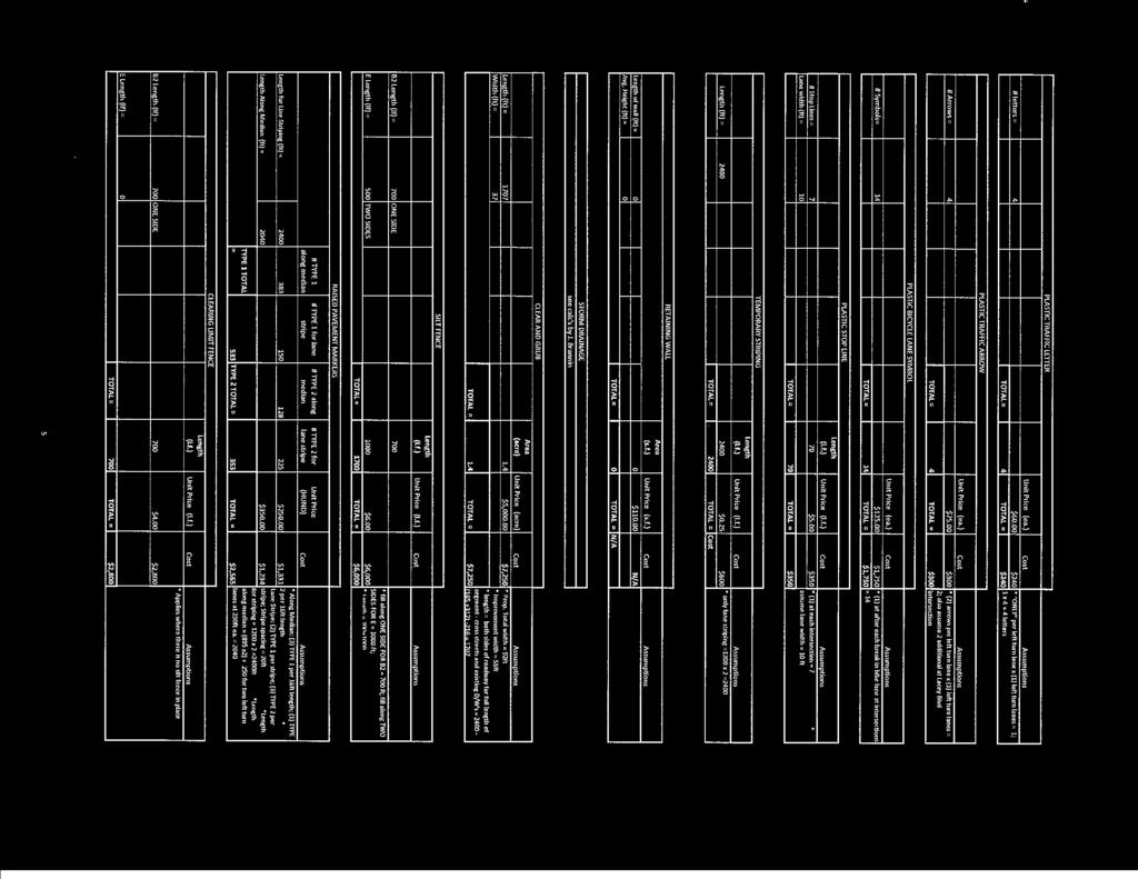

70
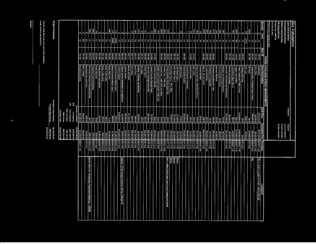

71

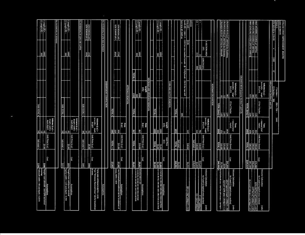

72

73

74
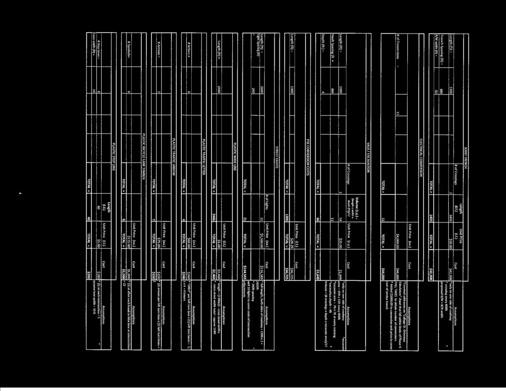

75
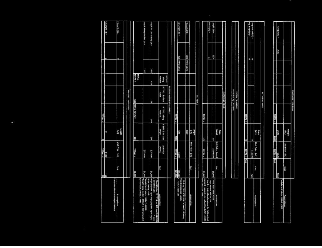

76

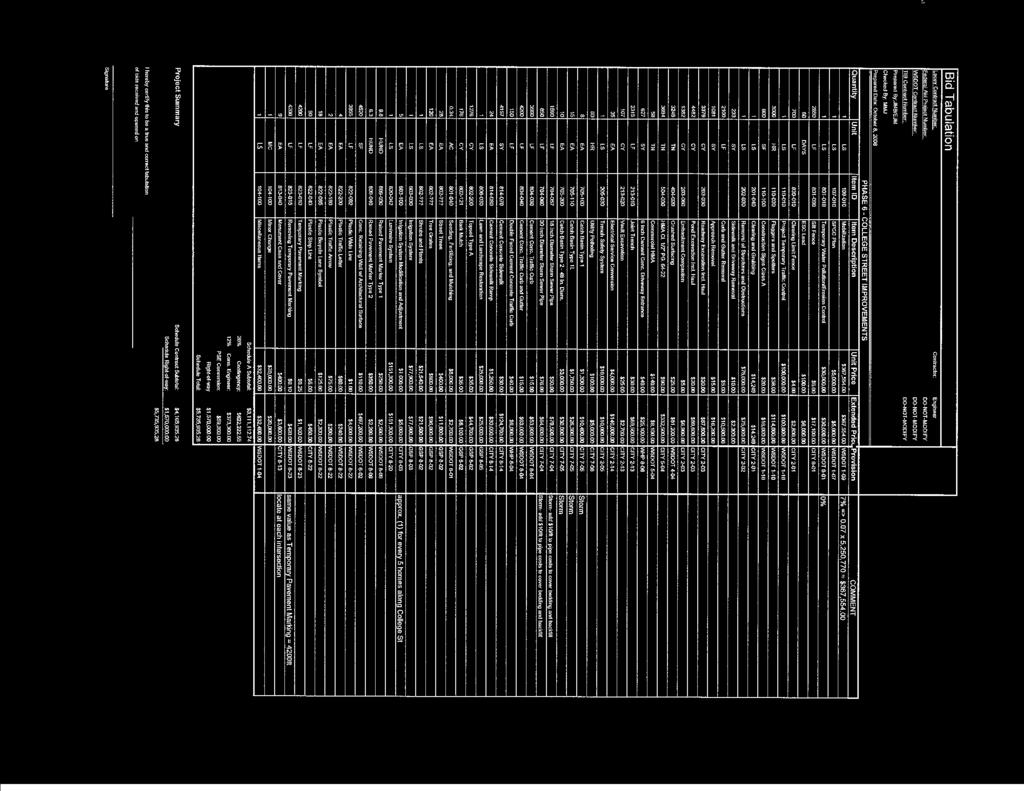

77
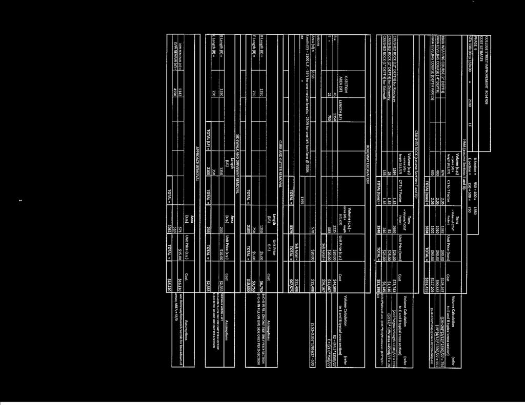

78

79

80
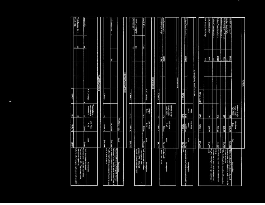

81
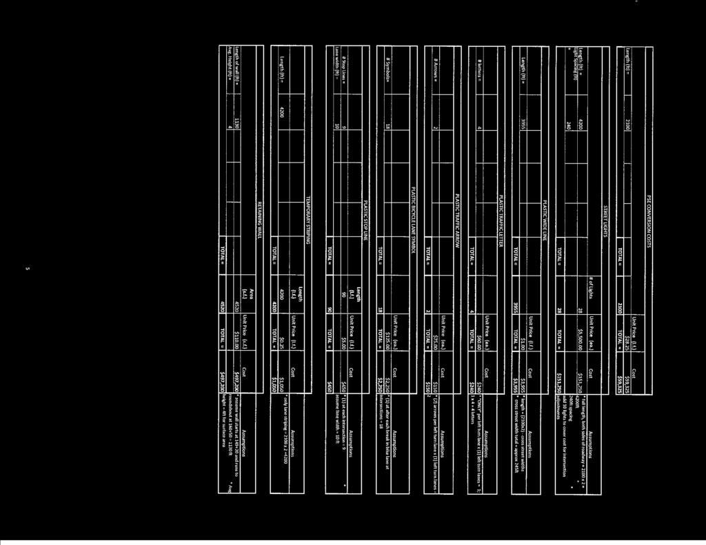

82

83
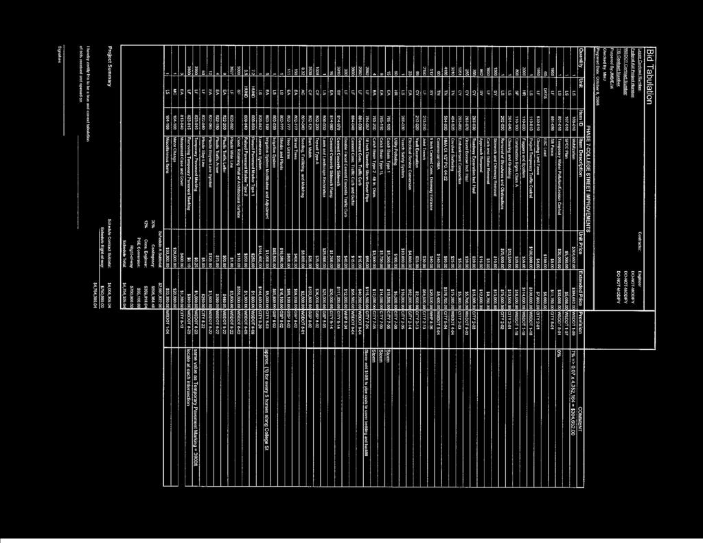

84

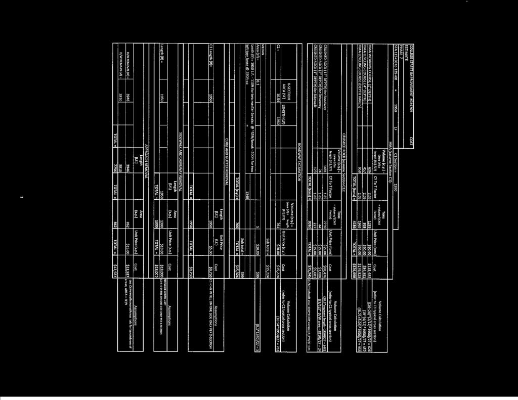

85

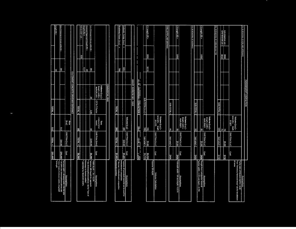

86
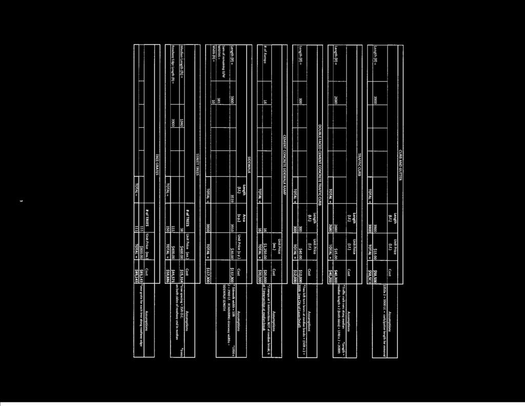

87

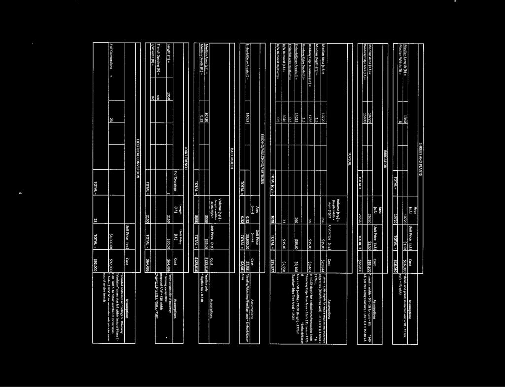

88

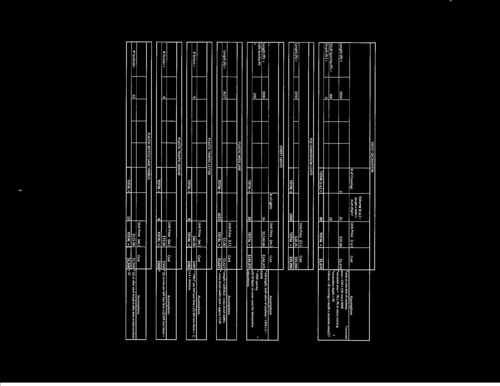

89
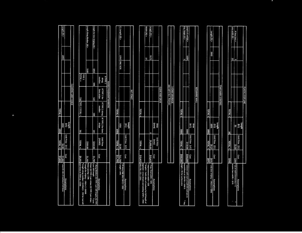

90
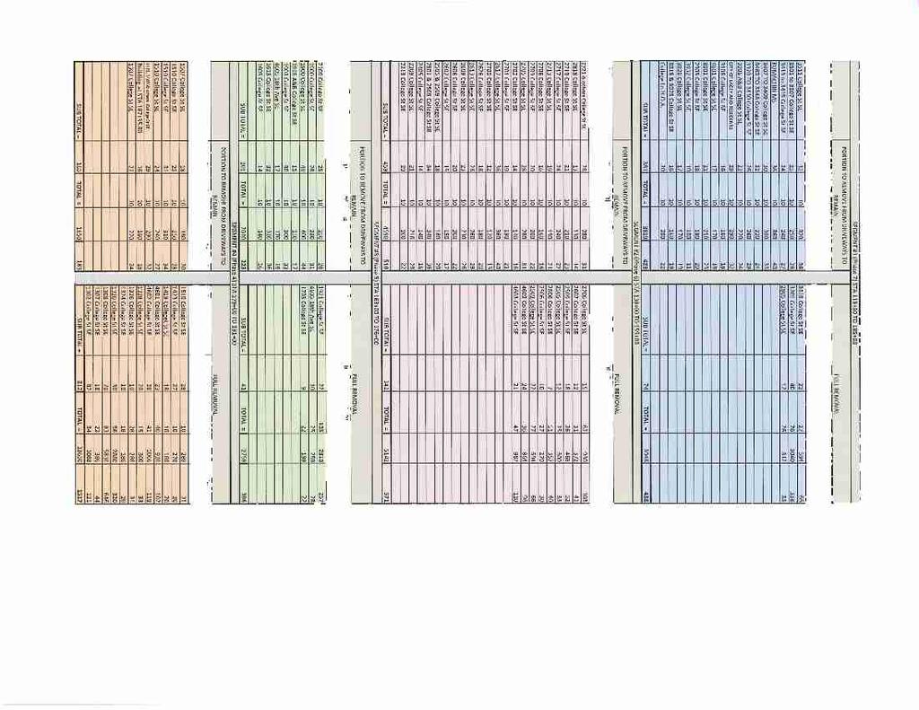

91
92 Appendix E
93
94 COLLEGE CORRIDOR STUDY Public Feedback Summary Combined from Oct. 9 and Nov How did you learn about tonight s Open House? Direct Mailing (73) Newspaper (33) Friend/Neighbor (7) Other: (8) 1. School Flyer (4) 2. Online (2) 3. Radio (1) 4. City Staff (1) 2. What situation describes you best? I live/work adjacent to College St (61) I live/work in the general vicinity of College St (39) I commute along the College Street Corridor (29) Other: (8) 1. Own property on 22 nd Ave 2. Walk and Bicycle 3. Have regional focus on alternative transportation 4. Elderly mother lives adjacent to College 5. Sister lives on College 6. Daughter goes to Mt View Elementary 7. Lives on other side of Ruddell 8. unspecified 3. How would you rate the current congestion/safety of College Street? College Street Current Conditions - Public Rating Results 60 Number of Responses Motor Vehicles Bicycles Pedestrians 0 Excellent Above Avg Average Below Avg Poor Congestion/Safety Value
95 4. Do you agree with the proposed plan? What changes would you make? Agree (58) Disagree (14) Suggested changes include: Increase Bike Lane width (7) Signalized intersections instead of Roundabouts (3) No Landscaping (3) Roundabouts are good solution (3) More and/or lighted crosswalks (2) Signal at 22 nd instead of Roundabout (2) Turn Lane instead of Median (2) Position Roundabouts where most traffic turns (2) Use shrubs instead of trees in median (2) Make College a one-way street (2) More Bus Shelters and Benches (2) Move 16 th Roundabout to 14 th (1) 4-Way Stop at 22 nd (1) Install Roundabout at 37 th (1) Turn Lane instead of median between 19 th and 22 nd (1) Crosswalks near Bus Stops (1) Consider pedestrian overpasses at Mt View and 16 th (1) Install Roundabout at 22 nd as soon as possible (1) Green line connector roads should be priority (1) These improvements would be great asset for growth of the community (1) Concern about financing given current state of economy (1) 5. What phase would you like to see constructed first if funding becomes available? The following construction phases are ranked in order of popularity Phase 1-22 nd and College Roundabout Phase 3-16 th and College Roundabout Phase 2-29 th and College Roundabout Phase 4 - Corridor section between Lacey Blvd and 16 th Ave Phase 5 - Corridor section between 16 th and 22 nd Phase 7 - Corridor section between 29 th and 37 th Phase 6 Corridor section between 22 nd and 29 th 6. Comments/ Suggestions? Some comments and suggestions include: Widen Bike Lanes (4) Install Signals instead of Roundabouts (4) Drivers do not yield right of way in Roundabouts (4) Concern about tax increases (3) Make College safer for Pedestrians (3) cont d
96 Turn Lane instead of Medians (2) Install flashing crosswalks (2) Reconsider Landscaping due to cost and long term maintenance (2) Use shrubs instead of trees in median (2) Well conceived plan (2) Build as soon as possible (2) Interest in environmental impact (2) Lower Speed Limit (2) Elderly and young drivers not familiar with Roundabouts (1) Install flashers in Pedestrian crossings at Roundabouts (1) Make Bus Stops and Public Transportation more attractive (1) Concern about emergency vehicles once improvements completed (1) How will traffic be affected during construction? (1) Open up dead ends on side streets (1) How is property value affected? (1) Concern about increased traffic noise (1) Address need for Pedestrian education (1) Much needed project to alleviate congestion and increase safety (1) Roundabouts are a waste of tax dollars (1) Existing street adequate except for cross traffic turns (1) Street tree additions, especially in median, look good (1) Encourage more use of Ruddell, Carpenter, and Boulevard (1) Incorporate Pedestrian overpasses (1) Extend school zones (1) What is the progress of the Mullen Rd extension? Thanks for being so prepared, and having so many available to answer questions. (1) I trust a red light more than a yield sign to stop traffic for children (1) Thanks for the opportunity to see what s going on (1) Make the left hand turnouts long enough for at least 4 cars (1) Provide right turn only lane from Lacey Blvd to College southbound (2) Provide as many as possible left turns (1) How many million will it cost and who will pay for it? (1) I agree with the plan 100%, it is very much needed (1) I would like to see fewer roundabouts in Lacey, not more (1) School Bus movements should be considered (1) Leave the midblock crosswalk at the School (1) As is, College St is dangerous and poorly lit (1)
97 Appendix F
98 724 Columbia Street NW, Suite 140 Olympia, Washington fax TECHNICAL MEMORANDUM Date: December 10, 2008 Rev 4/17/09 RE: Bike Lane Technical Memorandum To: Martin Hoppe, P.E., PTOE From: Scott Sawyer, P.E. Company: City of Lacey Title: Sr. Project Manager Phone: Phone: Fax: Fax: Address: 420 College Street SE Lacey, WA Project #: Project Name: College Street Improvement Report Purpose The purpose of this technical memorandum is (1) to address the public opinions concerning the space provided for bicycles, and (2) to present the costs associated with widening the roadway four feet to provide space for a Class II, five-foot wide bike lane. Summary The City of Lacey held public open houses on October 9 and November 5, 2008 to present the preferred design for College Street and to give opportunity for the public to voice comments and concerns. The City received some public concerns about the width provided for bicycles. Because of these public concerns, the City asked WHPacific to prepare cost estimates for increasing the curb to curb width to provide space for a Class II bike lane. We estimate the total additional costs at $1.7M to provide Class II bike lanes. Also, the five-foot bike lanes require full parcel acquisition of three additional homes sites. Study Area Background Previous Work Previous study work resulted in a report, College Street, Evaluation of Options, August This report documented a comprehensive alternatives analysis that scored and ranked ten options (nine build and one no-build) for improvements to College Street that addressed the corridor needs. Figure 1 - Vicinity Map The report recommended Option 9 as the preferred option, because it best provides a blend of corridor capacity, cost, neighborhood connectivity, nonmotorized uses, and corridor aesthetics. The cross-section included a planted center median to control access and provide space for left-turn lanes at key intersections; wide sidewalks with tree wells to

99 Technical Memorandum Bike Lane Widening Page promote walk-ability; space for commuting bicycles; and roundabouts at major intersections to provide intersection control. The overall right-of-way width of 72 feet widens to 76 feet at left-turn lane locations. The current study work began in February 2008 and consisted of the following tasks: Alternatives Analysis to define the recommended dimensions of the cross-sectional elements; Horizontal Alignment and Right-of-Way to define the recommended alignment; Neighborhood Circulation and Access to define recommended changes to street access and/or driveway access; and Improvements Phasing Plan to estimate project costs and define recommended phasing for the improvements. WHPacific prepared an Alternatives Analysis technical memorandum, dated April 11, The memorandum presented ranges of dimensions for roadway crosssectional elements (median width, leftturn lane width, through-lane width, space for bicyclists, planter/tree well width, and sidewalk width), and recommended a proposed crosssection for College Street for use in subsequent study work. The recommended cross-section is shown in Figure 2. Figure 2 Recommended Alternative The Alternative Analysis technical memorandum recommended shared roadways with a 14-foot outside lane for two principal reasons, (1) there is a multi-use trail (Chehalis-Western Trail) paralleling the corridor to the west, and (2) the 14-foot outside lanes reduce right-of-way impacts less home displacements and less costs. The recommendation was supported by the expectation most bicyclists will be Type A users (advanced or experienced riders), as defined by the AASHTO, Guide for the Development of Bicycle Facilities. 1 The recommended width matches bike routes on shared roadways used by the City of Lacey (enhanced Class III routes). The Alternative Analysis technical memorandum recommended 11-foot travel lanes as a practical minimum width (since the 10-foot lanes provide no buffer for trucks and/or buses considering their width from outside of mirror to outside of mirror). WHPacific subsequently prepared a Horizontal Alignment and Right-of-Way Limits technical memorandum, dated July 28, 2008, to determine the horizontal alignment with the least impact to rightof-way for the cross-section shown in Figure 2. The least impactful horizontal alignment by segment is: Segment 1 - Aligned against the existing easterly right-of-way line; Segment 2 - Aligned against the existing westerly right-of-way line; Segment 3 - Aligned against the existing easterly right-of-way line; and Segment 4 - Aligned against the existing westerly right-of-way line. 2 AASHTO, Guide for the Development of Bicycle Facilities, 1999, page 6.
M-58 HIGHWAY ACCESS MANAGEMENT STUDY Mullen Road to Bel-Ray Boulevard. Prepared for CITY OF BELTON. May 2016
 M-58 HIGHWAY ACCESS MANAGEMENT STUDY Prepared for CITY OF BELTON By May 2016 Introduction Missouri State Highway 58 (M-58 Highway) is a major commercial corridor in the City of Belton. As development has
Report. Typical Sections. City of Middleton, WI
 Report Typical Sections City of Middleton, WI December 2006 Report for City of Middleton, Wisconsin Typical Sections repared by: Traffic Associates LLC and STRAND ASSOCIATES, INC. 910 West Wingra Drive
DRAFT - CITY OF MEDFORD TRANSPORTATION SYSTEM PLAN Roadway Cross-Sections
 Roadway Cross-Sections Medford s roadway cross-section standards apply to new and reconstructed roads. The crosssections take into consideration roadway function and operational characteristics, including
Recommended Roadway Plan Section 2 - Land Development and Roadway Access
 Recommended Roadway Plan Section 2 - Land Development and Roadway Access SECTION 2 Land Development and Roadway Access 2.1 Land Use and Access Management The Federal Highway Administration (FHWA) defines
SECTION 1 - TRAFFIC PLANNING
 SECTION 1 - TRAFFIC PLANNING 1.1 TRAFFIC OPERATIONS 1.1.1 Roadway Functional Classification The Multnomah County Comprehensive Framework Plan s Policy 34: Trafficways and the Functional Classification
Multimodal Through Corridors and Placemaking Corridors
 68 Multimodal Through Corridors and Placemaking Corridors Corridors have different functions in a region. Some corridors are used to get smoothly and rapidly through a region or to get quickly to major
Making Great Urban Streets Confessions of a Highway Engineer. Timothy R. Neuman.. P.E. Chief Highway Engineer CH2M HILL
 Making Great Urban Streets Confessions of a Highway Engineer Timothy R. Neuman.. P.E. Chief Highway Engineer CH2M HILL Isn t this a Great Street? Characteristics of a Great Street It is a transportation
City of Wayzata Comprehensive Plan 2030 Transportation Chapter: Appendix A
 A1. Functional Classification Table A-1 illustrates the Metropolitan Council s detailed criteria established for the functional classification of roadways within the Twin Cities Metropolitan Area. Table
CURBSIDE ACTIVITY DESIGN
 5 CURBSIDE ACTIVITY DESIGN This chapter provides design guidance for separated bike lanes adjacent to curbside activities including parking, loading and bus stops. Typical configurations are presented
Lee s Summit Road Improvement Study Public Open House June 7, 2007 Summary of Comment Card Responses
 Lee s Summit Road Improvement Study Public Open House June 7, 2007 Summary of Comment Card Responses Introduction At the Lee s Summit Road Improvement Study Public Open House held Thursday, June 7, 2007
City of Elizabeth City Neighborhood Traffic Calming Policy and Guidelines
 City of Elizabeth City Neighborhood Traffic Calming Policy and Guidelines I. Purpose: The City of Elizabeth City is committed to ensure the overall safety and livability of residential neighborhoods. One
Chapter 2: Standards for Access, Non-Motorized, and Transit
 Standards for Access, Non-Motorized, and Transit Chapter 2: Standards for Access, Non-Motorized, and Transit The Washtenaw County Access Management Plan was developed based on the analysis of existing
Appendix 3 Roadway and Bike/Ped Design Standards
 Appendix 3 Roadway and Bike/Ped Design Standards OTO Transportation Plan 2040 4/20/2017 Page A3-1 Adopted Standards The adopted OTO Design Standards and Major Thoroughfare Plan are contained herein.
Classification Criteria
 SCHEDULE D TO RECOMMENDED OFFICIAL PLAN AMENDMENT NO. 40 SCHEDULE C-4 Road Criteria Criteria Traffic Service Objective Land Service/Access Typical Daily Traffic Volume Flow characteristics Travel Speed
Active Transportation Facility Glossary
 Active Transportation Facility Glossary This document defines different active transportation facilities and suggests appropriate corridor types. Click on a facility type to jump to its definition. Bike
Exhibit 1 PLANNING COMMISSION AGENDA ITEM
 Exhibit 1 PLANNING COMMISSION AGENDA ITEM Project Name: Grand Junction Circulation Plan Grand Junction Complete Streets Policy Applicant: City of Grand Junction Representative: David Thornton Address:
APPENDIX A: Complete Streets Checklist DRAFT NOVEMBER 2016
 APPENDIX A: Complete Streets Checklist DRAFT NOVEMBER 2016 Complete Streets Checklist MetroPlan Orlando s Complete Streets Checklist is an internal planning tool for staff to further implementation of
What Is a Complete Street?
 Session 5 Charleen Zimmer, AICP, Zan Associates May 5-7, 2010 What Is a Complete Street? May 2010 5-1 Not a Complete Street More of a Complete Street May 2010 5-2 Benefits of Complete Streets Safety for
Main-McVay Transit Study: Phase 2 Options Definition and High Level Constraints Evaluation
 Main-McVay Transit Study: Phase 2 Options Definition and High Level Constraints Evaluation APRIL 2016 A collaborative study between: For Additional Information or to Comment If you would like additional
WYDOT DESIGN GUIDES. Guide for. NHS Arterial (Non-Interstate)
") WYDOT DESIGN GUIDES Guide for NHS Arterial (Non-Interstate) 2014 GUIDE FOR NATIONAL HIGHWAY SYSTEM (NHS) HIGHWAYS (NHS ARTERIALS, Non-Interstate) PRESERVATION REHABILITATION RECONSTRUCTION INTRODUCTION
WYDOT DESIGN GUIDES Guide for NHS Arterial (Non-Interstate) 2014 GUIDE FOR NATIONAL HIGHWAY SYSTEM (NHS) HIGHWAYS (NHS ARTERIALS, Non-Interstate) PRESERVATION REHABILITATION RECONSTRUCTION INTRODUCTION
Complete Street Analysis of a Road Diet: Orange Grove Boulevard, Pasadena, CA
 Complete Street Analysis of a Road Diet: Orange Grove Boulevard, Pasadena, CA Aaron Elias, Bill Cisco Abstract As part of evaluating the feasibility of a road diet on Orange Grove Boulevard in Pasadena,
Geometric Design Tables
 Design Manual Chapter 5 - Roadway Design 5C - Geometric Design Criteria 5C-1 Geometric Design Tables A. General The following sections present two sets of design criteria tables - Preferred Roadway Elements
BETHEL ROAD AND SEDGWICK ROAD CORRIDOR STUDY
 DRAFT PLAN City Council Meeting August 14, 2017 STUDY AREA Sedgwick Corridor State Route 160, principal arterial with Class 3 access management designation, commuter and freight route, connection to SR
On Road Bikeways Part 1: Bicycle Lane Design
 On Road Bikeways Part 1: Bicycle Lane Design Presentation by: Nick Jackson Bill Schultheiss, P.E. September 04, 2012 FOLLOW THE CONVERSATION ON TWITTER Toole Design Group is live tweeting this webinar
1609 E. FRANKLIN STREET HOTEL TRAFFIC IMPACT STUDY EXECUTIVE SUMMARY
 1609 E. FRANKLIN STREET HOTEL TRAFFIC IMPACT STUDY EXECUTIVE SUMMARY Prepared for: The Town of Chapel Hill Public Works Department Traffic Engineering Division Prepared by: HNTB North Carolina, PC 343
WYDOT DESIGN GUIDES. Guide for. Non-NHS State Highways
 WYDOT DESIGN GUIDES Guide for Non-NHS State Highways 2014 GUIDE FOR Non-NATIONAL HIGHWAY SYSTEM (Non-NHS) STATE HIGHWAYS PRESERVATION REHABILITATION RECONSTRUCTION INTRODUCTION This Guide is directed to
Access Management Regulations and Standards
 Access Management Regulations and Standards Efficient highway operation Reasonable property access Concept of Access Management The way to manage access to land development while simultaneously preserving
Public Information Centre
 WELCOME Public Information Centre Father Tobin Road Lougheed Middle School - Library Wednesday November 7, 2012 7:00 p.m.to 9:00 p.m. Please sign in Neighbourhood Traffic Calming Guide Background The City
Citizen Advisory Group Meeting #8 May 5, Welcome. Today s meeting will focus on: Land Use & Transportation CHARLOTTEPLANNING.
 Citizen Advisory Group Meeting #8 May 5, 2010 Welcome. Today s meeting will focus on: Land Use & Transportation CHARLOTTEPLANNING.ORG Meeting Agenda Handouts: o Meeting Agenda o Summary of East Seventh
C C C
 C-012-001 Thank you for your support for the creation of new public space and nonmotorized access between downtown and the waterfront through the Overlook Walk, the East-West Connections, and the Promenade.
Omaha s Complete Streets Policy
 Omaha s Complete Streets Policy (Adopted August 2015) VISION To create great places and enhance our quality of life, the City of Omaha will provide safe, accessible streets for all users. Complete Streets
City of Seattle Edward B. Murray, Mayor
 City of Seattle Edward B. Murray, Mayor Department of Transportation Scott Kubly, Director Eastlake Community Council 117 E Louisa St. #1 Seattle, WA 98102-3278 January 28, 2016 RE: Roosevelt to Downtown
WELCOME Public Information Centre
 WELCOME Public Information Centre Fernforest Drive Brampton Soccer Centre Community Room #2 Tuesday January 19, 2016 6:30 p.m.to 9:00 p.m. Please sign in Neighbourhood Traffic Calming Guide Background
5. RUNNINGWAY GUIDELINES
 5. RUNNINGWAY GUIDELINES These guidelines should be considered collectively when making runningway decisions. A runningway is the linear component of the transit system that forms the right-of-way reserved
Summary: Mercer County Princeton Avenue & Spruce Street Study January 2009
 Summary: Several recent studies have assessed potential development and redevelopment opportunities in the Mercer Crossing area of Trenton, Ewing, and Lawrence. This Princeton Avenue and Spruce Street
CHAPTER 7 ACCESS MANAGEMENT. Background. Principles of Access Management. Hennepin County Transportation Systems Plan (HC-TSP)
") CHAPTER 7 ACCESS MANAGEMENT Background Principles of Access Management Hennepin County Transportation Systems Plan (HC-TSP) Chapter 7 Access Management 7.1 Background Access management has become an important
CHAPTER 7 ACCESS MANAGEMENT Background Principles of Access Management Hennepin County Transportation Systems Plan (HC-TSP) Chapter 7 Access Management 7.1 Background Access management has become an important
Broad Street Bicycle Boulevard Design Guidelines
 Broad Street Bicycle Boulevard Design Guidelines Building from the strategies introduced in the 2013 Bicycle Transportation Plan and community input received thus far, City Transportation Staff have identified
CHAPTER 16 PEDESTRIAN FACILITIES DESIGN AND TECHNICAL CRITERIA TABLE OF CONTENTS
 CHAPTER 16 PEDESTRIAN FACILITIES DESIGN AND TECHNICAL CRITERIA TABLE OF CONTENTS Section Title Page 16.1 General... 16-1 16.1.1 AASHTO Reference... 16-1 16.1.2 ADA Requirements... 16-1 16.2 Sidewalks...
122 Avenue: 107 Street to Fort Road
 : 107 Street to Fort Road November 24, 2015 4:30 8:00 p.m. Meeting Purpose Summarize project work completed to date Share results of public input from Phase 1 Share the draft concept plan and proposed
Clackamas County Comprehensive Plan
 ROADWAYS The County s road system permits the movement of goods and people between communities and regions, using any of a variety of modes of travel. Roads provide access to virtually all property. They
THE FUTURE OF THE TxDOT ROADWAY DESIGN MANUAL
 THE FUTURE OF THE TXDOT ROADWAY DESIGN MANUAL Kenneth Mora, P.E. (Design Division) 10/10/2017 Table of contents 1 2 Reduction in FHWA design controlling criteria Innovative Intersection Guidance 3-7 8-42
City of Sammamish. Welcome. Issaquah-Fall City Road Improvements Project Phase I Design: 242nd Avenue SE to Klahanie Drive SE
 Welcome Welcome to the third community meeting for the Issaquah-Fall City Road Improvements Project. AGENDA 6:00 p.m. Welcome and sign-in 6:10 p.m. Presentation 6:50 p.m. Open house Learn about the roadway
Columbia Pike Implementation Team (CPIT) Meeting
 Meeting") Columbia Pike Implementation Team (CPIT) Meeting November 30, 2010 Agenda Introductions / Purpose of Meeting Review of project goals Multimodal project: 10% street design between the curbs Discussion Multimodal
Columbia Pike Implementation Team (CPIT) Meeting November 30, 2010 Agenda Introductions / Purpose of Meeting Review of project goals Multimodal project: 10% street design between the curbs Discussion Multimodal
Roadways. Roadways III.
 Introduction 97 Roadway Design Principles 98 Safe Speeds 99 Optimizing of Street Space 00 Minimum Lane Widths in the City of Boston 02 Design Features that Reduce Operating Speeds 05 Travel Lanes Transit
4.0 TRAFFIC IMPACT STUDIES
 SECTION 4 4.0 TRAFFIC IMPACT STUDIES 4.1 TRAFFIC IMPACT STUDY REQUIREMENTS The City has established Traffic Impact Study (TIS) requirements for the purpose of ensuring that both the quantitative and qualitative
FONTAINE AVENUE STUDY Final Report
 FONTAINE AVENUE STUDY Final Report March 28, 2005 FONTAINE AVENUE STUDY City of Charlottesville March 28, 2005 Renaissance Planning Group Kenneth Schwartz, FAIA, AICP Director of Design Leigh Wilkerson,
Access Location, Spacing, Turn Lanes, and Medians
 Design Manual Chapter 5 - Roadway Design 5L - Access Management 5L-3 Access Location, Spacing, Turn Lanes, and Medians This section addresses access location, spacing, turn lane and median needs, including
West Dimond Blvd Upgrade Jodhpur Street to Sand Lake Road
 West Dimond Blvd Jodhpur St to Sand Lake CSS Transportation Project Summary Municipality of Anchorage Project # 05 005 Project Manager: John Smith, P.E. (MOA PM&E) Project Administrator: Julie Makela,
LSC TRANSPORTATION CONSULTANTS, INC. 516 North Tejon Street Colorado Springs, CO (719) FAX (719)
 FAX (719)") LSC TRANSPORTATION CONSULTANTS, INC. 516 North Tejon Street Colorado Springs, CO 80903 (719) 633-2868 FAX (719) 633-5430 E-mail: lsc@lsccs.com May 15, 2009 Mr. Davis Farrar Western Slope Consulting, LLC
LSC TRANSPORTATION CONSULTANTS, INC. 516 North Tejon Street Colorado Springs, CO 80903 (719) 633-2868 FAX (719) 633-5430 E-mail: lsc@lsccs.com May 15, 2009 Mr. Davis Farrar Western Slope Consulting, LLC
THE ALAMEDA CONCEPT DESIGN COMMUNITY MEETING 3. A Plan for The Beautiful Way JANUARY 28, 2010
 CONCEPT DESIGN COMMUNITY MEETING 3 JANUARY 28, 2010 AGENDA INTRODUCTION COMMUNITY INPUT ROADWAY STUDIES STREETSCAPE DESIGN STATIONS DISCUSSION SUMMARY AND DISCUSSION NEXT STEPS CLOSE INTRODUCTION SCHEDULE
NJDOT Complete Streets Checklist
 Background The New Jersey Department of Transportation s Complete Streets Policy promotes a comprehensive, integrated, connected multi-modal network by providing connections to bicycling and walking trip
RZC Appendix 8A Marymoor Subarea Street Requirements
 RZC Appendix 8A Marymoor Subarea Street Requirements For additional design details for Marymoor Subarea infrastructure, refer to the 2017 Marymoor Subarea Infrastructure Planning Report. STREET REQUIREMENTS
Traffic Impact Memorandum. May 22, 2018
 BISHOP PROFESSIONAL DEVELOPMENT BUILDING Proposed Land-use Change & Parking Modification 3601 SW 31st Street Topeka, Kansas 66614 CFS Project No. 185077 Traffic Impact Memorandum May 22, 2018 Prepared
2.0 LANE WIDTHS GUIDELINE
 2.0 LANE WIDTHS GUIDELINE Road Engineering Design Guidelines Version 2.0.1 May 2018 City of Toronto, Transportation Services City of Toronto Page 0 Background In early 2014, Transportation Services initiated
REGIONAL BICYCLE AND PEDESTRIAN DESIGN GUIDELINES
 REGIONAL BICYCLE AND PEDESTRIAN DESIGN GUIDELINES November 16, 2011 Deb Humphreys North Central Texas Council of Governments Bicycle and Pedestrian Advisory Committee Snapshot of the Guide 1. Introduction
City of Madison, East Johnson Street North Baldwin Street to First Street Local Street Dane County
 City of Madison, East Johnson Street North Baldwin Street to First Street Local Street Dane County Public Involvement Meeting Thursday, November 10, 2016 5:30 to 7 P.M. Festival Foods 810 E. Washington
Item to be Addressed Checklist Consideration YES NO N/A Required Description Complete Streets Guidelines
 Passaic County Complete Streets Checklist - Concept Development Project Name Item to be Addressed Checklist Consideration YES NO N/A Required Description Complete Streets Guidelines Existing Plans Have
CITY OF WEST LAKE HILLS. Forest View Neighborhood Traffic Calming Study
 CITY OF WEST LAKE HILLS 901 South Mopac Expressway Building V, Suite 220 Austin, Texas 78746 Texas P.E. Firm Registration No. F-929 Klotz Associates Final Report Submittal: March 20, 2015 Revised Final
Intersection Traffic Control Feasibility Study
 Intersection Traffic Control Feasibility Study CSAH 9 at CSAH 60 (185th Avenue) Prepared For: Dakota County Transportation Department Western Service Center 14955 Galaxie Avenue, 3rd Floor Apple Valley,
Route 7 Corridor Study
 Route 7 Corridor Study Executive Summary Study Area The following report analyzes a segment of the Virginia State Route 7 corridor. The corridor study area, spanning over 5 miles in length, is a multi
Defining Purpose and Need
 Advanced Design Flexibility Pilot Workshop Session 4 Jack Broz, PE, HR Green May 5-6, 2010 Defining Purpose and Need In your agency s project development process, when do design engineers typically get
Fleur Drive Reconstruction
 Fleur Drive Reconstruction October 29, 2018 1 Agenda: Fleur Drive Reconstruction Project Scope & Cost Overview Fleur Drive Cross Section Elements - Travel Lane Widths - Sidewalk Widths - Parkway Widths
Comments EXECUTIVE SUMMARY
 Comments 1. Under any Alternatives, MCDOT should provide better at-grade pedestrian crossing of Georgia Avenue and Forest Glen Road, including improved crosswalks with wider medians and adequate signal
MEMORANDUM. Earl Haugen and UND Transportation and Traffic Coordination Committee
 SRF No. 7766 MEMORANDUM TO: FROM: Earl Haugen and UND Transportation and Traffic Coordination Committee Rick Lane, P.E. DATE: November 26, 2013 SUBJECT: UNIVERSITY AVE REVIEW Our review of the University
Who is Toole Design Group?
 2018 AASHTO Bike Guide Status Update NCHRP 15 60 Amalia Leighton Cody, PE, AICP & Kenneth Loen, PE Washington APWA October 4, 2018 Who is Toole Design Group? TDG is a full service engineering, planning
City of Gainesville Transportation/Roadway Needs PROJECT SUMMARY
 A1 Roadway Resurfacing $23,846,000 TYPE: Preservation of existing system Roadway resurfacing A2 Signal Replacement $6,000,000 TYPE: Preservation of existing system Replace traffic signals. B1 W 6th St
Mission-Geneva Transportation Study Community Workshop 2 July 8, 2006
 Community Workshop 2 July 8, 2006 Small Group Workbook 1 Basic Improvements on Mission Street Streetscape. Pedestrian-scale lighting; landscaping; community art on utility boxes; more (possibly unique)
Planning Guidance in the 2012 AASHTO Bike Guide
 Planning Guidance in the 2012 AASHTO Bike Guide Presentation by: RJ Eldridge Peter Lagerwey August 22, 2012 WEBINAR 2: PLANNING GUIDANCE IN THE 2012 AASHTO BIKE GUIDE Today s Webinar Significant Updates
Tonight is an opportunity to learn about the Study and ask questions of the Study Team members.
 Exhibit 1 Welcome Second Open House Tonight is an opportunity to learn about the Study and ask questions of the Study Team members. A first Public Open House was held on September 18th, 2013 which presented
David DiPierro, John Amberson. Steering Committee Meeting #4 Overview
 IBI GROUP 18401 Von Karman Avenue Suite 110 Irvine CA 92612 USA tel 949 833 5588 fax 949 833 5511 ibigroup.com Memorandum To/Attention Steering Committee Members Date February 17, 2016 From IBI Group Project
ACTIVE TRANSPORTATION
 ACTIVE TRANSPORTATION Mobility 2040 Supported Goals Improve the availability of transportation options for people and goods. Support travel efficiency measures and system enhancements targeted at congestion
Chapter 3 BUS IMPROVEMENT CONCEPTS
 Chapter 3 BUS IMPROVEMENT CONCEPTS The purpose of this chapter is to describe potential bus improvement strategies and potential impacts or implications associated with BRT implementation within the existing
INDEX. Geometric Design Guide for Canadian Roads INDEX
 Acceleration lane, see Lanes, Acceleration Access, 8.1 Access Management and Functional Classification 8.2 Access Management by Design Classification 8.3 Access Configuration 8.4 Building Set-Back Guidelines
Route 29 Corridor Assessment Update. Development of Possible Solutions
 Route 29 Corridor Assessment Update Development of Possible Solutions Public Workshop #3 October 27, 2016 Purpose of Developing Possible Solutions Recap of where we ve been and timeline for moving forward
Appendix C. TRAFFIC CALMING PROGRAM TOOLBOX
 Appendix C. TRAFFIC CALMING PROGRAM TOOLBOX PHASE I...2 Do Not Enter Sign...3 One-Way Sign...4 Turn Prohibition...5 Pavement Markings...6 Speed Monitoring Trailer...7 Neighborhood Speed Watch...8 Police
Application of a Complete Street
 Application of a Complete Street Southbend to Prima Vista Update May 14, 2018 Meeting Agenda Perspective and History Public input received Typical sections being considered Presentation of the 2-lane master
INTRODUCTION THOROUGHFARE SYSTEM CLASSIFICATIONS
 INTRODUCTION The thoroughfare plan will assist public officials in the development of a specialized system for efficient and safe movement of vehicular traffic while minimizing potential conflicts with
Aurora Urban Street Standards For Transit Oriented Developments and Urban Centers
 Aurora Urban Street Standards For Transit Oriented Developments and Urban Centers I. Purpose These standards will be applied to create a safe, comfortable, pleasant and pedestrian-friendly multi-modal
Roadway Classification Design Standards and Policies. Pueblo, Colorado November, 2004
 Roadway Classification Design Standards and Policies Pueblo, Colorado November, 2004 Table of Contents Page Chapter 1. General Provisions 1.1 Jurisdiction 3 1.2 Purpose and Intent 3 1.3 Modification 3
Safe Routes to School: Munroe Elementary Walk Audit Report. Image: Drexel, Barrell & Co.
 Safe Routes to School: Munroe Elementary Walk Audit Report Image: Drexel, Barrell & Co. April 12, 2016 OVERVIEW As part of the 2014/2015 Denver Safe Routes to School (SRTS) Program, WalkDenver coordinated
Information on display. Inside this handout. Triangle Area revisions. Project need displays. Preferred alternative on aerial maps
 Public information meeting #4 4 to 7 p.m., September 30, 2009 Hales Corners Welcome Thank you for attending this public information meeting for the WIS 100 Corridor Study. Your interest and comments are
Roadway Design Manual
 Roadway Design Manual Manual Notice Archive by Texas Department of Transportation (512) 302-2453 all rights reserved Manual Notice 2009-1 From: Manual: Mark A. Marek, P.E Roadway Design Manual Effective
Road Diets FDOT Process
 Florida Department of TRANSPORTATION Road Diets FDOT Process Humberto Castillero, PE, PTOE Roadway Design Office Purpose of Guide Develop a statewide lane elimination review process Balance state & local
Driveway Design Criteria
 Design Manual Chapter 5 - Roadway Design 5L - Access Management 5L-4 Driveway Design Criteria A. General For efficient and safe operations, access drives and minor public street intersections can be improved
Proposed. City of Grand Junction Complete Streets Policy. Exhibit 10
 Proposed City of Grand Junction Complete Streets Policy Exhibit 10 1 City of Grand Junction Complete Streets Policy Vision: The Complete Streets Vision is to develop a safe, efficient, and reliable travel
4.0 ACCESS CONTROL PLAN - SH 14 (JEFFERSON STREET/RIVERSIDE AVENUE)
") 4.1 Existing Conditions Roadway Physical Characteristics Typical Sections Jefferson Street 4.0 ACCESS CONTROL PLAN - SH 14 (JEFFERSON STREET/RIVERSIDE AVENUE) The existing typical cross-section for SH
4.1 Existing Conditions Roadway Physical Characteristics Typical Sections Jefferson Street 4.0 ACCESS CONTROL PLAN - SH 14 (JEFFERSON STREET/RIVERSIDE AVENUE) The existing typical cross-section for SH
RESOLUTION NO ?? A RESOLUTION OF THE CITY OF NEPTUNE BEACH ADOPTING A COMPLETE STREETS POLICY
 RESOLUTION NO. 2018-?? A RESOLUTION OF THE CITY OF NEPTUNE BEACH ADOPTING A COMPLETE STREETS POLICY WHEREAS, safe, convenient, and accessible transportation for all users is a priority of the City of Neptune
Technical Memorandum. Shoulder Width Standards for State Highways. Expiration. Implementation. Introduction. Purpose
 Minnesota Department of Transportation Engineering Services Division Technical Memorandum No. 17-12-TS-05 Technical Memorandum To: Electronic Distribution Recipients From: Nancy T. Daubenberger, P.E. Divison
Governance and Priorities Committee Report For the July 2, 2015 Meeting
 CITY OF VICTORIA For the July 2, 2015 Meeting To: Governance and Priorities Committee Date: From: Subject: Brad Dellebuur, A/Assistant Director, Transportation and Parking Services Executive Summary The
Corridor Recommendations and Implementation
 Corridor Recommendations and Implementation INTER-PARCEL CONNECTIVITY Both alternative Concept A and Concept B segments of the Community Core suggest a system of interconnected local streets and local
Boston Post Road Design Feasibility Study
 Boston Post Road Design Feasibility Study Prepared for the City of Rye Final Report July 18, 2007 Prepared by: Buckhurst Fish & Jacquemart (BFJ) 115 Fifth Avenue New York, NY 10003 www.bfjplanning.com
PEDESTRIAN ACCOMMODATIONS DPS 201 AT INTERCHANGES
 PEDESTRIAN ACCOMMODATIONS DPS 201 AT INTERCHANGES UNDERSTANDING THE ISSUES Intersections of freeway ramp terminals at crossroads are the most critical components of an interchange Challenge: balance mobility
Off-road Trails. Guidance
 Off-road Trails Off-road trails are shared use paths located on an independent alignment that provide two-way travel for people walking, bicycling, and other non-motorized users. Trails specifically along
Active Transportation Access to Transit
 Active Transportation Access to Transit Introduction COMO Connect customers access transit service in many ways, including walking, bicycling, riding in a car and being dropped off, and directly boarding
In station areas, new pedestrian links can increase network connectivity and provide direct access to stations.
 The Last Mile Planning for Pedestrians Planning around stations will put pedestrians first. Making walking to stations safe and easy is important; walking will be a part of every rapid transit Accessible
APPENDIX 2 LAKESHORE ROAD TRANSPORTATION REVIEW STUDY EXECUTIVE SUMMARY
 APPENDIX 2 LAKESHORE ROAD TRANSPORTATION REVIEW STUDY EXECUTIVE SUMMARY Appendix 2 City of Mississauga Lakeshore Road FINAL REPORT Transportation Review Study December 2010 EXECUTIVE SUMMARY Study Purpose
WELCOME! Please complete a comment sheet as we value your feedback. 4 pm to 8 pm. September 15, Hosted by: AECOM on behalf of City of Calgary
 WELCOME! Thank you for attending our open house. There will be no formal presentation today so please take the time to read the boards. If you have any questions, please do not hesitate to approach one
Houma-Thibodaux Metropolitan Planning Organization STP<200K Funding Application APPLICATION
 APPLICATION HOUMA-THIBODAUX METROPOLITAN PLANNING ORGANIZATION (HTMPO) FOR SURFACE TRANSPORTATION PROGRAM (STP
City of Davis East Covell Corridor Plan
 Community Open House #2 January 22, 2014 6:00 8:00 p.m. Veterans Memorial Center, Club Room City of Davis Introduction The (ECCP) is a taking a comprehensive look at the existing transportation systems
Safety Impacts: Presentation Overview
 Safety Impacts: Presentation Overview The #1 Theme How Access Management Improves Safety Conflict Points The Science of Access Management By Treatment Studies Themes for Texas Access Management Improve