Ministry of Education Flat Bush School Notice of Requirement. Integrated Transportation Assessment Report. February 2016
|
|
|
- Baldwin Holmes
- 5 years ago
- Views:
Transcription


1 Ministry of Education Flat Bush School Notice of Requirement Integrated Transportation Assessment Report February 2016 TDG Ref: ita flat bush.docx
2 Ministry of Education Flat Bush School Notice of Requirement Integrated Transportation Assessment Report Quality Assurance Statement Prepared by: Michael Hall Project Transportation Engineer Reviewed by: Max Robitzsch Principal Transportation Engineer Approved for Issue by: Daryl Hughes Director Status: Final Date: 18 February 2016 PO Box 2592, Shortland Street, Auckland 1140 New Zealand P: ITA Flat Bush
3 Integrated Transportation Assessment Report Table of Contents 1. Introduction Existing Transport Context Site Location Public Transport Road Network Walking and Cycling Road Safety Proposal School and Childcare Proposed Road Improvements Trip Generation and Expected Mode Share Primary School Childcare Centre Trip Generation Summary Intersection Modelling Assessment of Effects Walking and Cycling Effects Public Transport Traffic Capacity Parking Access Mitigation of Impacts Integration with Future Transport Network Consultation with Auckland Transport Conclusions... 26
4 Integrated Transportation Assessment Report Page 1 1. Introduction TDG was commissioned by The Ministry of Education to prepare an Integrated Transport Assessment ( ITA ) for a new primary school and childcare to be built on Flat Bush School Road in Flat Bush, Auckland. As a Requiring Authority, the Ministry of Education is seeking a Notice of Requirement to enable this process. This report follows the Auckland Transport guidelines for the preparation of an ITA. The purpose of the report is to establish if the site in question is suitable for situating a school and childcare, rather than to focus upon the details of how these institutions will be constructed or operate.
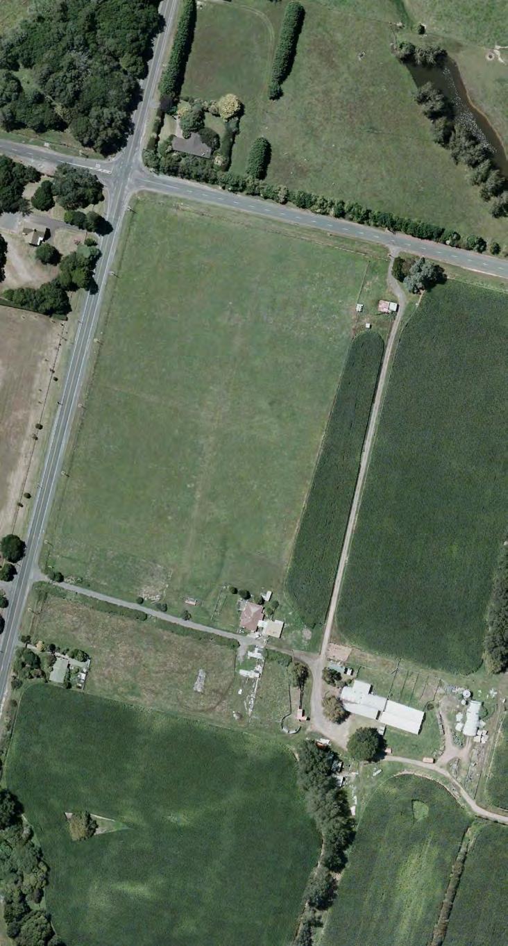
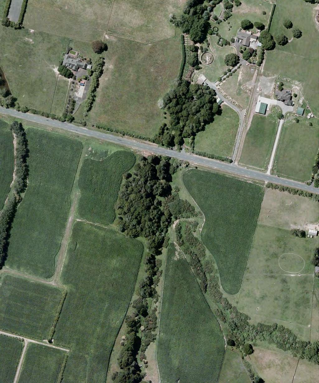
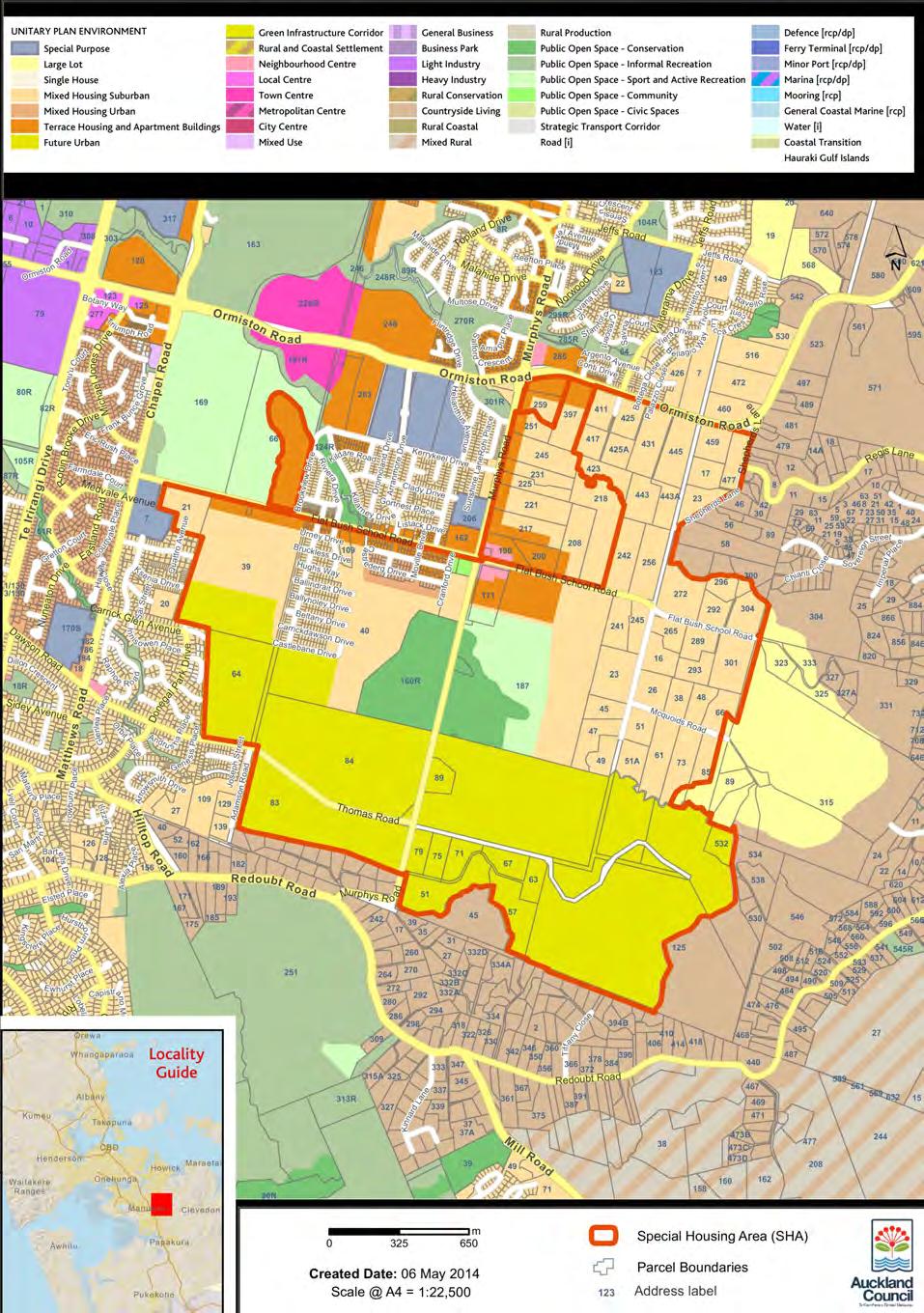
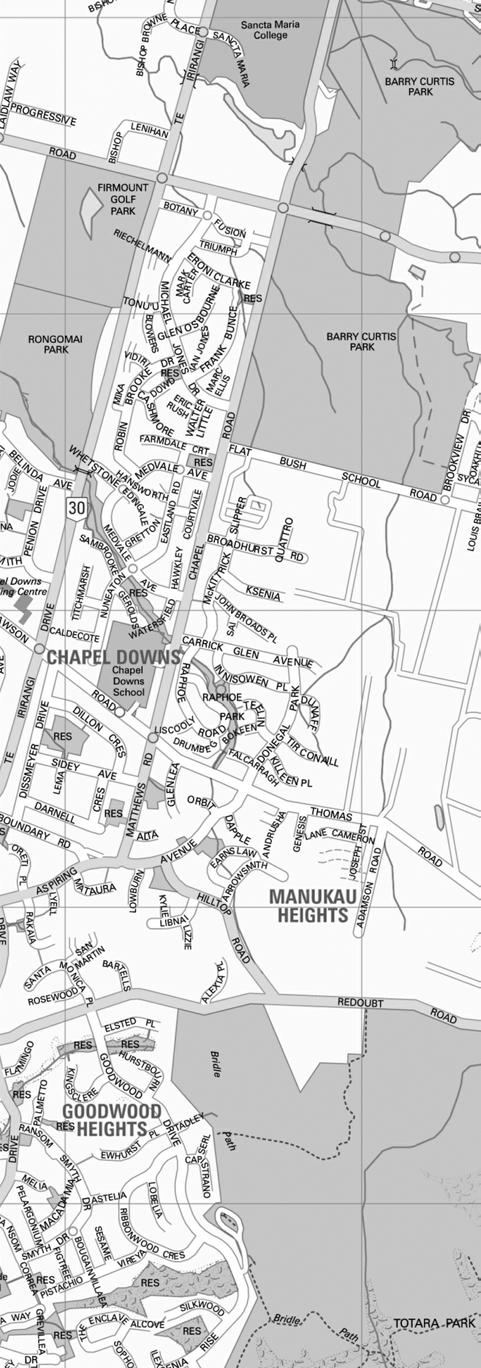
5 Integrated Transportation Assessment Report Page 2 2. Existing Transport Context 2.1 Site Location The proposed school site is located on Flat Bush School Road approximately 300m east of its intersection with Murphys Road. The surrounding land is currently mostly rural but that is rapidly developing into mainly suburban housing. Initial residential developments already exist on Flat Bush School Road on the western side of Murphys Road. Figure 1 shows an aerial photo of the site and its surroundings. A large Special Housing Area ( SHA ) allowing expedited consenting and development has been announced by Auckland Council and a developer just north of the proposed school site. Furthermore, a strategic SHA has been declared over the wider surrounding area, with both shown in Figure 2. This strategic overlay identifies that any further developers in this area who apply for SHA status are likely to be approved relatively directly by Council. While neither the specific SHA nor the strategic overlay provide certainty of actual development, they indicate plans for significant and potentially relatively speedy development in the area. Regarding zoning, the surrounding areas are mainly Flat Bush Residential 3 according to the Auckland Council District Plan Operative Manukau Section ( District Plan ), with a Flat Bush Neighbourhood Centre zoning on the area around the eastern side of the Flat Bush School Road / Murphys Road intersection, towards the school side. This allows medium-tohigh density residential development in the area surrounding the school. While high density may not eventuate in the near future, it is considered that the surrounding area has a potential for large numbers of housing units. 2.2 Public Transport Currently there are no public bus services that serve Flat Bush School Road or Murphys Road in the vicinity of the site. The nearest bus route is the 589, located over 1km away on Ormiston Road, which connects Botany Town Centre with Beachlands and Maraetai. A peak hour bus route is proposed to run along the Flat Bush School Road frontage of the site. This is shown as part of the consultation currently underway for the eastern suburbs of Auckland. This route will begin once the Flat Bush area is developed. The frequency of services is unknown but is only likely to run during the morning and evening peak periods which will be suitable to serve the school staff and students. In addition, a connector route will run approximately 500m from the site. This route will have a higher frequency and run all day which may be able to act as an alternative public transport option. The bus stop locations for these routes are yet to be determined however it is likely that a stop will be provided within 100m of the school for the peak period service. A school is already in place on the north-western corner of the intersection between Murphys Road and Flat Bush School Road. The connector route is likely to have stop near this location which will make them approximately 600m walking distance from the proposed school site. The nearest train station is Manukau Train Station which is approximately 4.8km southwest of the site.
6 Integrated Transportation Assessment Report Page Road Network Figure 3 shows the location of the site in relation to the surrounding road hierarchy as defined by the District Plan.
7
8
9
10 Integrated Transportation Assessment Report Page Flat Bush School Road Flat Bush School Road is the site s main frontage road, on its northern edge. It is currently classified as a local road in the District Plan. From the Flat Bush plan change ( PC20 ) supporting documents, and our assessment of the likely function, we would expect that this will eventually be changed to at least a Collector Road status, where, compared to a local road, through movement is emphasised slightly higher than local access. However, this is not considered a concern for a school facility. A traffic count was undertaken by Auckland Transport in May The count location was some short distance to the west of Murphys Road and showed an Annual Average Daily Traffic ( AADT ) of 2,966 vehicles, which is comparatively low. It is noted that traffic flows on Flat Bush School Road east of Murphys Road (at the potential school site) would be expected to be significantly lower than this due to the lack of onward connectivity or development in that direction. While new development of the area over the next decades will significantly increase traffic volumes, it is always likely to remain significantly lower than in the western sections, due to the lack of onward connectivity to the east, which will be of some benefit for the school, particularly in terms of access and walking / cycling safety and convenience. The ART3 Model, which is maintained by Auckland Transport, is the regional model that covers the whole of the Auckland area. The model was used to estimate the peak hour future flows on Flat Bush School Road and the surrounding area for the expected land use scenario for The future flows across the frontage of the proposed school are shown in Table 1 below. Direction AM Peak PM Peak Eastbound Westbound Total Table 1: Estimated Traffic Volumes for 2026 on Flat Bush School Road The road along the site frontage currently has a 100 km/h speed limit. It is expected, with the zoning and proposed development around it, that this will eventually be dropped to 50 km/h as appropriate in an urban / suburban area. The procedures outlined in Land Transport Rule would be used to determine what the speed limit should be and the presence of a school is likely to result in a 50 km/h speed limit being posted. This speed reduction should be implemented before the opening of the school. Rule also considers other developments near the school which also impact upon the outcomes of the procedure. The process should be undertaken closer to the time the school is opened. The road in the vicinity of the site is sealed and has one lane in each direction. It has a very straight alignment (which creates a tendency among drivers to speed though speed surveys have not been undertaken as part of this assessment).
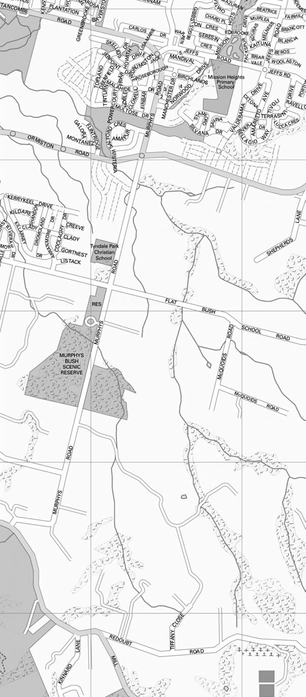
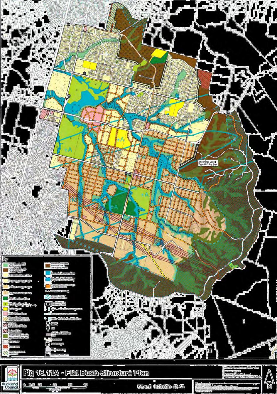
11 Integrated Transportation Assessment Report Page Murphys Road This is the nearest major north-south road, some 300m west of the site. It is classified as a District Regional Arterial in the District Plan. While this is the lowest level of the arterial road classifications, this in general terms means that it prioritises movement over access. A traffic count was undertaken by Auckland Transport in June The count some distance to the north of Flat Bush School Road showed an AADT of 11,001 vehicles. This is already relatively high, and is expected to increase further with development. Future peak hour traffic volumes for Murphys Road were taken from the ART3 model. The volumes for 2026 along Murphys Road are shown in Table 2 below. Location Direction AM Peak PM Peak North of Flat Bush School Road South of Flat Bush School Road Northbound Southbound Total 980 1,065 Northbound Southbound Total 890 1,025 Table 2: Estimated Traffic Volumes for 2026 on Murphys Road Similarly to Flat Bush School Road, it currently has a posted speed-limit of 100 km/h in the vicinity of the site, has no footpaths, and only some partial cycle lanes. All these aspects are likely to change as the area upgrades, in line with the discussion already provided above for Flat Bush School Road Future Roads Council s long term plans as envisaged in the Flat Bush Structure Plan ( Structure Plan ) shown in Figure 4 provide for a variety of future roads near the site. Many of these will change slightly or possibly even more significantly as developers construct their subdivisions, but we note the following three roads that are proposed to border the school s possible site (the names are given for convenience in discussing these in the assessment, and are not official names): West Road a short local road running north-south along the western boundary of the site. This road has no real network function, and will simply form a road to allow traffic to access local properties. South Road a somewhat longer road running west-east along the southern boundary of the site. Again, this road has only very limited network function. East Road a potentially very long road running along the eastern boundary, which continues north and south of the site for significant distances.
12 Integrated Transportation Assessment Report Page 9 None of these three roads would be required to be in place for the operation of the site as a school, though they could potentially assist with route and access options. In particular, East Road has a potential positive effect in that it would add local connectivity from the surrounding areas especially residential areas lying directly to the north and south of the school, including for walking and cycling. As a potential negative effect, if developed as a north-south through route through the large new residential areas, for several kilometres in length as shown in the Structure Plan, it could also see significant motor vehicle traffic. This could imply a need to more strongly consider pedestrian crossing opportunities and traffic calming near the site vicinity, to not create severance that would deter walking and cycling to school. It is noted that the school site may be surrounded by roads on all four sides. This also highlights the need to consider pedestrian crossing opportunities and traffic calming on these roads to avoid severance that would deter walking and cycling to school. 2.4 Walking and Cycling Flat Bush School Road has no footpaths or other pedestrian facilities at this stage. Implementation of continuous footpaths to the surrounding residential and commercial areas being developed will be an important factor for establishing a school here, and this should be undertaken before opening a school. Pedestrian crossings have been installed across all four legs of the signalised intersection between Flat Bush School Road and Murphys Road. Flat Bush School Road currently has no cycle facilities near the site, although cycle lanes (on-road, without physical protection from motor vehicles) have been implemented on the road west of the Murphys Road intersection, and have been implemented on the approach to the signalised intersection with Murphys Road. It is expected that these will be extended further east as the road is upgraded in line with the area s development. It is suggested that this will be a positive factor for establishing a school here. If future cycle lane facilities would be upgraded to a higher standard (protected cycle lanes), these would also assist cycle safety for younger children (i.e. the current cycle lanes are not considered ideal for a primary school). Murphys Road is similar to Flat Bush School Road in that there are no footpaths or pedestrian facilities. Cycle lanes have been constructed on the approach to the intersection between Murphys Road and Flat Bush School Road and it is planned for these to be extended in the future along the full length of Murphys Road.
13 Integrated Transportation Assessment Report Page Road Safety A search was made of the New Zealand Transport Agency s Crash Analysis System for all reported crashes for the full five year period from 2010 to 2014 including all available results for 2015 on Flat Bush School Road from its intersection with Murphys Road to McQuoids Road. The search found that a total of 15 crashes were reported within the study of which eight resulted in minor injuries. Only one crash occurred on Flat Bush School Road that was not at the intersection with Murphys Road. This crash was due to a driver s attention being diverted by an animal or insect in the car and losing control of the vehicle. The car went off the road to left and hit a ditch. No crashes were reported along the frontage of the site. No crashes were reported that involved pedestrians or cyclists. As such, there are no road safety issued observed relating to the site.
14
15 Integrated Transportation Assessment Report Page Proposal 3.1 School and Childcare The Notice of Requirement would enable a primary school and a childcare centre to be built on the southern side of Flat Bush School road approximately 300m east of its intersection with Murphys Road. It is likely that school would start with a small number of students serving the first nearby residential developments in the Flat Bush area, and eventually accommodate up to 700 students. The childcare centre, which will operate like a preschool, will be designed to accommodate up to 50 children. It is expected that at least one pedestrian crossing will be required around the school. The exact location of the crossing cannot be determined until the school design is complete and pedestrian access to the school is identified. This process comes after the Notice of Requirement and forms part of the subsequent Outline Plan of Works. In addition to providing education for children during the day the school may also offer after school educational programs for children and adults. The school may also be used as venue for sporting and cultural activities that may take place outside of school hours. 3.2 Proposed Road Improvements Flat Bush School Road to the west of Murphys Road has been recently upgraded to cater for the new developments along this section of road. The upgrades included the installation of kerbs, channels, berms and footpaths on both sides of the road. It is understood that Auckland Transport proposes to continue this arrangement on Flat Bush School Road on the eastern side of Murphys Road, although the timing or funding of this has not yet been fixed. Based on the structure plan shown in Figure 4, the site is likely to front roads on all of its boundaries. Currently there are only plans to construct the road along the western boundary of the site by the time the school opens. The time frames for the remaining two roads are not yet known. The school is not dependant on any of these surrounding roads to be completed prior to opening day.
16 Integrated Transportation Assessment Report Page Trip Generation and Expected Mode Share 4.1 Primary School The school will prepare and maintain a School Travel Management Plan. This will be implemented within the first term of the school opening and will have as an objective the safe transportation of students to and from school that does not depend on private vehicles. Walking school buses and covered bicycle parking areas will be included as part of the plan. The plan will be monitored and updated over time as the travel needs change Mode Share The Ministry of Transport publishes on its website a sample of surveyed travel patterns for school students since The data for children aged 5 to 12 is shown in Table 3 below. Mode 1989/ / Walk (only) 42% 30% 26% 25% 24% 23% 22% 24% 28% 29% Car Passenger 31% 45% 55% 56% 55% 57% 58% 58% 56% 55% Car Passenger + Walk 1% 2% 1% 1% 1% 1% 1% 2% 2% 2% Bicycle 12% 7% 5% 4% 4% 3% 3% 3% 2% 2% Public Transport 7% 7% 6% 5% 6% 6% 7% 7% 4% 4% Walk + PT 4% 6% 4% 7% 6% 6% 6% 4% 4% 5% Car Passenger + PT 2% 2% 2% 2% 2% 2% 2% 3% 2% 3% Other 1% 1% 1% 1% 1% 1% 0% 1% 1% 1% Total 100% 100% 100% 100% 100% 100% 100% 100% 100% 100% Table 3: Ministry of Transport Journey to School (Ages 5-12) For the latest period ( ) the Auckland Region data is provided and can be compared with the national data, as shown below in Figure 5 below.
17 Integrated Transportation Assessment Report Page 14 Figure 5: Mode Share for Journey to Auckland Schools (Ages5-12) This data gives a reasonable basis for estimating future travel to the school by car, walking cycling and public transport School Traffic Generation For the Auckland Region, the number of students cycling to school was measured at 0%. For the other regions surveyed this percentage is 3%-4%. Given that the school is being built to serve the local community and that cycling facilities are proposed to be created it is considered that there will be students that will cycle to school. Therefore, for cyclists, the national average of 2% will be considered. This 2% will be taken from trips made by car passengers. Using the observed Auckland mode share (slightly adjusted to account for cyclists) and applying that to the estimated 700 students who will ultimately attend the school, the number of person trips generated can be calculated. These are shown in Table 4 below:
18 Integrated Transportation Assessment Report Page 15 Mode Mode Share Percentage Person Trips Generated Walk (only) 38% 266 Car Passenger 53% 371 Car Passenger + Walk 1% 7 Bicycle 2% 14 Public Transport 1% 7 Walk + PT 2% 14 Car Passenger + PT 2% 14 Other 1% 7 Total 100% 700 Table 4: Person Trips by Mode Of the 371 children likely to be dropped at the school gate by car, it is considered that many of these children will be in the same car as a sibling. Statistics NZ suggest there is an average of 1.9 children per household in New Zealand. Of these children in the household, some families will have a second or third child that is either too young or too old to attend the same school. Hence the number of children being dropped off from the same vehicle will be reduced by 10% and taken as 1.7. No allowance has been made for any potential car sharing which will reduce the number of trips generated even further. This equates to a total of 436 trips (218 vehicles) generated by private vehicle every morning and afternoon in the peak period. The number of car trips generated by the school staff member is likely to be influenced by the number of car parks provided on-site. Staff members are likely to not arrive before students start arriving and depart after students have departed. Hence these trips are not likely to add to the peak period trips. In the longer term, as the area around the school develops, it is expected that more children will walk or cycle to school and the number of children being driven to school will decrease. This is more likely as the school will be serving a local catchment. 4.2 Childcare Centre The New South Wales Road and Traffic Authorities Guide to Trip generating Developments ( RTA Guide ) provides trip generation for childcare centres. The childcare centre will operate like a pre-school facility and the trip generation rates for such an activity are 1.4 trips per child. For a centre with 50 children in attendance, 70 vehicular trips are expected to be generated in the peak hour.
19 Integrated Transportation Assessment Report Page Trip Generation Summary Based on the 436 vehicular trips generated by the primary school and the 70 trips generated by the childcare centre, the total number of trips expected to be generated by the site is 506. The vast majority of these will be made by parents dropping off their children at school and therefore we can consider that half of these trips will be made to the site and the remainder will be from the site. Currently, Flat Bush School Road experiences no congestion and is therefore considered to be able to accommodate the additional trips generated by the school and childcare centre. 4.4 Intersection Modelling Based on the future flows obtained from the ART3 Model from Auckland Transport and the expected number of trips expected to be generated by the site, a SIDRA model was prepared of the intersection between Flat Bush School Road and Murphys Road. It was conservatively assumed that all trips generated by the site will use this intersection in order to provide a robust assessment. Generated trips were distributed in the same proportion as the traffic volumes from the 2026 ART3 model. The morning and evening peak periods were modelled and the results are shown in Table 5 below. The geometric design of the intersection was not changed from its current layout. The performance measures shown below are the average delay experienced by vehicles due to waiting at the intersection, the queue length for each movement and the LOS rating which gives an A-F grade for each movement where A is a really good performance. Approach Movement AM Peak PM Peak Ave Delay (s) LOS 95% Q (m) Ave Delay (s) Murphys Road (South) Left 25.9 C C 16.1 LOS 95% Q (m) Through 21.8 C C 56.1 Right 37.6 D D 54.7 Flat Bush School Road (East) Left 34.9 C C 42.5 Through 29.3 C C 45.5 Right 38.6 D D 43.2 Murphys Road (North) Left 32.7 C D 61.6 Flat Bush School Road (West) Through 27.0 C C 64.2 Right 36.0 D C 10.7 Left 27.7 C C 40.0 Through 22.1 C C 40.0 Right 34.4 C C 17.5 All Vehicles 30.9 C C - Table 5: Intersection Performance
20 Integrated Transportation Assessment Report Page 17 The modelling results show that the intersection performs adequately for an urban intersection. As such it is considered that this intersection will be able to accommodate the trips generated by the proposed school and childcare facility.
21 Integrated Transportation Assessment Report Page Assessment of Effects 5.1 Walking and Cycling Effects It is considered important for the school, and for the safety of children walking to school, that a good walking environment exists in the vicinity and on the main routes to school. This is currently not provided, but it is understood that development planned by Council and Auckland Transport for the area includes a variety of changes that should help ensure adequate or even good walking environments. When the school reaches its maximum intended roll size of 700 students, it is expected that approximately 266 children will walk for at least part of their trip. In particular it will be important that, by the time the school is operational, most or all of the following has occurred: Flat Bush School Road in the vicinity of the site has been reduced from a 100 km/h speed limit to 50 km/h or less. Footpaths to the school exist on both sides of the surrounding roads, ideally on both sides as good practice recommends for a safe and convenient walking network. Bus stops are in place along or near the school frontage on Flat Bush School Road. One or more dedicated pedestrian crossing points are implemented over Flat Bush School Road in the direct school vicinity. The proposed off-road path network (mainly located along stormwater and parks reserves) proposed for Flat Bush (see black dotted lines in Figure 1) is being developed progressively to follow development, and provides a good local connection to the school site. The existing narrow road bridge to the east of the school in the road dip has been replaced by a new bridge which provides footpaths currently there is very little settlement to the east, but this is planned to change, and at that stage the existing bridge would form a serious safety barrier to walking to school from there. In summary, the existing pedestrian environment around the site at the moment is poor due to the lack of facilities and the 100 km/h speed environment; however, this is expected to be changed substantially as part of the development of the wider area. Incorporating design of the school routes into the area design and ensuring the staging of these upgrades matches the school needs would be the key requirements. However, for the purposes of the NOR, it is concluded that from a walking perspective, the site will be suitable. The data taken from the Ministry of Transport suggests that there will a negligible amount of trips made by bicycle. Auckland Transport are however creating policies and strategies to encourage cycling to school and increase this mode share. A safe cycle lane would be the single greatest improvement that could be made to encourage cycling to and from the school. Many of the improvements that are planned, or already developed around Flat Bush, are paint-only on-road cycle lanes, which will see little uptake by primary school children, and only some limited uptake by secondary school children.
22 Integrated Transportation Assessment Report Page 19 Unless Auckland Transport upgrades these facilities further than currently appears to be planned (to protected cycle lanes or off-road cycle paths), cycling to school along the main roads will likely remain limited. A more promising possibility would be the proposed walking and cycling network Council is planning to progressively develop along the parks and stormwater reserves of Flat Bush. Such a shared path system one of whose major branches is proposed to pass just east of the school, would be likely to offer a much more attractive route for cycling to school, and could potentially see greater levels of cycling uptake. In particular it will be beneficial if, by the time the school is operational, most or all of the following has occurred: The existing cycle lanes on Flat Bush School Road have been extended to at least as far east as the school frontage. The walking and cycling network in the stormwater reserves is extended as far as possible (in line with development occurring around it) and provides a safe connection to the school at Flat Bush School Road or along the eastern site frontage. This would require a shorter cycle path rising out of the lower-level storm water reserve. In summary, as is the case for walking, the cycling environment around the site at the moment is poor (due to the lack of facilities and the 100 km/h speed environment); however, this is expected to be changed somewhat as part of the development details to be dealt with under the OPW. Incorporating design of the school routes into the area design and ensuring the staging of these upgrades matches the school needs would be the key requirements. 5.2 Public Transport As mentioned in section 2.2, Auckland Transport is in the process of upgrading the bus network for Auckland. The new network for East Auckland is expected to be implemented in The current consultation documents outlining the proposed network note that the route passing the frontage of the school will take effect once the area develops however there may be sufficient development in place already once the network is implemented for the is route to be running. Buses could be significant for the school if a bus service dedicated to school runs is implemented for the surrounding areas. If this is considered, the later design of the school grounds should allow for bus circulation / bus stops. There is nothing in the site location or proposed transport network that would be considered to prevent such school bus services in the near or long term.
23 Integrated Transportation Assessment Report Page Traffic Capacity Flat Bush School Road does not currently experience any traffic issues as it carries low traffic volumes. The intersection between Flat Bush School road and Murphys Road also experiences very low levels of congestions. As growth occurs in the local area, traffic volumes will increase. The arterial classification of Murphys indicates that this route is intended to accommodate reasonably high traffic flows. Accounting for the current intended levels of future development it is unlikely that Flat Bush School Road will become congested. 5.4 Parking The Outline Plan of Works will need to address the specific details of how and where parking is to be provided for the school and childcare centre. The current Notice of Requirement process needs to provide an assessment of the likely parking issues and present conditions to ensure that adequate parking and access is provided Primary School In carrying out this assessment it is considered that there will be approximately one teacher for every 25 students (28 teachers in total in 28 classrooms), a principal, a care taker, two office administration staff and five teacher aides. This equates to a total of 37 staff. The District Plan requires a minimum parking rate of two spaces for every three staff members employed on site or operating from the site at any one time and a suitable drop off area. Based on having 37 staff on-site, the school would need to provide at least 25 parking spaces. The parking rates for land that is designated for education purposes by the Ministry of Education are separate and independent of the stand parking rates that apply Auckland wide. The minimum number of parking spaces for school facilities is two spaces per classroom. For a school of 28 classrooms this equates to a minimum parking space provision requirement of 56 spaces. Given that the maximum number of staff is expected to be 37 people and considering that every staff member drives their own vehicle to the school, a car park of 44 spaces is expected to adequately meet the requirements of the school during the day. As the school caters for children within the primary school age bracket, there will be no students driving to school. The peak parking time for a primary school typically occurs in the afternoon when children are collected at the end of the school day. It would not be reasonable to build an off-street car park to deal with an intense short-lived peak parking demand of that nature. While modern best-practice recommends encouraging methods of school travel such as walking, cycling or public transport, it is considered likely that for the near future, a significant part of children at a school in this location would arrive by private car. As such, any school s design needs to balance providing for the safety of such private car traffic without degrading other modes or access, or wasting large parts of the site on car parking.
24 Integrated Transportation Assessment Report Page Childcare Centre To carry out the assessment of the childcare centre, it is considered that there will be five staff members employed on-site. This is in accordance with the minimum staff member requirements for childcare centres as stipulated by New Zealand Legislation. The District Plan requires a minimum parking rate of one space for every staff member employed on-site plus one for every ten children where there is parental participation. Considering the conservative assumption that there is parental participation, the childcare centre would be required to provide ten parking spaces. The Ministry of Education has also designated parking rates for childcare centres (preschools) that are independent of the standard parking rates that apply in Auckland. In addition to any parking required for a school, one space should be provided for every ten children the facility is designed to accommodate plus one for every full time equivalent staff member operating on-site. These rates are concordant with the District Plan rates; hence the requirement for the childcare centre is still to provide a minimum of ten parking spaces. The provision of ten parking spaces is considered suitable for a childcare centre with a maximum of 50 children in attendance Parking Summary The total number of spaces that is likely to be required to be provided by the site is 54 spaces, 44 for the primary school and ten for the childcare centre. The final and exact parking numbers will be determined at a later stage of the design and consenting process once there is more certainty around the final scope and layout of the school and childcare centre. Some spaces will be dedicated for staff usage and remainder will be primarily used by parents picking up or dripping off their children. It is considered that the size of the site, and the various surrounding existing and future roads, provides enough flexibility to accommodate these requirements, including the potential for dedicated drop-off zones. 5.5 Access The site currently has one road frontage and that is onto Flat Bush School Road. Based on the future road network plans for the area, the site will likely have frontage on all four sides. However these new roads are unlikely to have been constructed by the time the school opens. In the meantime, Flat Bush School Road will be the primary access point for the school both for pedestrians and vehicular traffic.
25 Integrated Transportation Assessment Report Page Mitigation of Impacts The transportation effects of the proposed development can be mitigated through the development of the following works: Posted speed to limit reduction along Flat Bush School Road from 100km/h to 50km/h. Kerb and Channel is to be provided on Flat Bush School Road across the site frontage. Installation of bus stops near the frontage of the site on Flat Bush School Road to cater for the future bus routes serving the area. Construction of footpaths on both sides of Flat Bush School that extend east and west to provide pedestrian access to the surrounding neighbourhoods. Construct a pedestrian crossing across Flat Bush School road to provide a safe pedestrian crossing point including catering for primary school children. Provide a vehicle access point to the school with parking suitable to meet the expected demand. A suitable drop off and pick area should also be included on-site. Addition of bike racks within the school grounds to provide storage for bikes when children are in class. Discussions relating to how these aspects will be designed or funded will be undertaken during the Outline Plan of Works stage. For the purposes of this report and the NOR, it is considered that each of these are achievable, and therefore the site is suitable for a school and childcare centre.
26 Integrated Transportation Assessment Report Page Integration with Future Transport Network Figure 6 shows the projects that Auckland Transport are currently proposing, investigating, designing and constructing in the Flat Bush area. The figure shows that the intersection between Flat Bush School Road and Murphys Road is in the construction phase of its upgrade. The remaining projects along Murphys Road are still in the design phase. A bridge on a new road that will connect to the proposed along the eastern boundary of the site is proposed to begin construction sometime around 2019 to It is unlikely that the proposed road connecting this bridge to the surrounding road network would be completed before this date. Other than the intersection with Murphys road, no projects are currently planned for the Flat Bush School Road corridor. The construction of a school may result in a change in Auckland Transport priorities for the area. The proposed new bus network for the Auckland region does not result in any new or improved routes in the vicinity of the site. No extension to the rail network is proposed through the Flat Bush area. The site does not currently integrate well with the future public transport networks as they have been currently proposed however as the area becomes more developed this is likely to change. As stated previously, for the purposes of this report and the NOR, it is considered that the site is suitable for a school and childcare centre, as it will be able to integrate with the future transport network.

27 Integrated Transportation Assessment Report Page 24 Figure 6: Current Auckland Transport Projects in Flat Bush
28 Integrated Transportation Assessment Report Page Consultation with Auckland Transport A meeting was held on 10 November 2014 with Council specialists, Auckland Transport, and the applicant s consultant team. Auckland Transport s representative questioned how Flat Bush School Road was to be designed to accommodate a low-speed environment. Such detail is not required for the purposes of this report and the NOR process, however, there are several means that may be adopted during the detailed design and OPW processes that would serve to minimise traffic speeds and enhance overall road safety. These may include carriageway narrowing, or vertical / horizontal traffic calming devices. Auckland Transport also enquired as to funding arrangements for the construction of Flat Bush School Road. Again, this will be dealt with in subsequent stages, following the NOR process.
29 Integrated Transportation Assessment Report Page Conclusions This report considers the appropriateness of an NOR for a proposed school and childcare centre on Flat Bush School Road in Flat Bush. The following conclusions were reached: The provision of a school and childcare centre in the area integrates well with the future transport network as it fulfils an expected need for children to be educated locally without needing to travel to other more distant areas. The existing and future roading layouts will enable motorists, cyclists and pedestrians to approach the site from all directions. The site can be developed in such a way that adverse effects can be avoided, remedied or mitigated. The site is therefore considered suitable for the proposed activities and is not likely to lead to adverse effects. The Notice of Requirement is therefore appropriate from a traffic and transport perspective. TDG
Ministry of Education Notice of Requirement, North City High School. Transportation Assessment Report. July 2010
 Ministry of Education Notice of Requirement, North City High School Transportation Assessment July 2010 PO Box 1261, Level 1, 7 Hardley Street Hamilton 3240 P: +64 7 839 550 www.tdg.co.nz New Zealand 10574ta_v6.doc
Transport Assessment. Curtis Street Plan Change
 Transport Assessment Curtis Street Plan Change Transport Assessment for Curtis Street Plan Change i Contents 1. Introduction... 1 2. Existing Conditions... 2 2.1 Location... 2 2.2 Study Area... 3 2.3
Harriet Fraser Traffic Engineering & Transportation Planning
 Appendix 5: Traffic Assessment 71 26 February 2015 Mr James Beban Senior Resource Consents Planner Cuttriss Consultants Ltd PO Box 30429 Lower Hutt PO Box 40170 Upper Hutt 5140 P 04 526 2979 M 027 668
Classification Criteria
 SCHEDULE D TO RECOMMENDED OFFICIAL PLAN AMENDMENT NO. 40 SCHEDULE C-4 Road Criteria Criteria Traffic Service Objective Land Service/Access Typical Daily Traffic Volume Flow characteristics Travel Speed
Shotover Country. Proposed Private Plan Change. Transportation Assessment Report. February 2010
 Shotover Country Proposed Private Plan Change February 2010 PO Box 13 835, Armagh Christchurch 8141 P: +64 3 379 2404 www.tdg.co.nz New Zealand Shotover Country Proposed Private Plan Change Quality Assurance
Response to further information request Ministry of Education Notice of Requirement (200 & 252 Park Estate Road)
") 21 Pitt Street PO Box 6345, Auckland 1141, New Zealand T: +64 9 300 9000 // F: +64 9 300 9300 E: info@beca.com // www.beca.com Auckland Council Private Bag 92300 Victoria Street West Auckland 1142 15 August
21 Pitt Street PO Box 6345, Auckland 1141, New Zealand T: +64 9 300 9000 // F: +64 9 300 9300 E: info@beca.com // www.beca.com Auckland Council Private Bag 92300 Victoria Street West Auckland 1142 15 August
EXECUTIVE SUMMARY Callan Park accommodates travel from a wide range of transport modes, including walking, cycling, bus and light rail.
 TRANSPORT AND ACCESS EXECUTIVE SUMMARY Callan Park accommodates travel from a wide range of transport modes, including walking, cycling, bus and light rail. Whilst there are some walking facilities within
PROPOSED RESIDENTIAL SUBDIVISION
 PROPOSED RESIDENTIAL SUBDIVISION PART OF TARNEIT ROAD & 1121 DOHERTYS ROAD, TARNEIT Prepared For: TCG (RM) Developments Pty Ltd MARCH 2014 OUR REF: 16740R#1 PROPOSED RESIDENTIAL SUBDIVISION PART OF TARNEIT
CITY OF OTTAWA ROADWAY MODIFICATION APPROVAL UNDER DELEGATED AUTHORITY
 RMA-2015-ATM-038 CITY OF OTTAWA ROADWAY MODIFICATION APPROVAL UNDER DELEGATED AUTHORITY DATE: April 22, 2015 SUBJECT Approval of Roadway Modifications Recommended through an Area Traffic Management Study
Kings College, Otahuhu Proposed Plan Change. Integrated Transportation Assessment Report
 Proposed Plan Change Integrated Transportation Assessment Report 23 October 2017 Project: Report title: Document reference: Kings College, Otahuhu Integrated Transportation Assessment Report J00700 Kings
Appendix 5 Traffic Assessment
 Appendix 5 Traffic Assessment 44 Harrison Transportation Best Start Educare Shelly Bay Road Beachlands Transportation Assessment Report September 2017 PO Box 11 557 Palm Beach Papamoa 3151 Reference: 187
TRAFFIC IMPACT ANALYSIS
 TRAFFIC IMPACT ANALYSIS FOR THE CHAMPAIGN UNIT#4 SCHOOL DISTRICT PROPOSED HIGH SCHOOL (SPALDING PARK SITE) IN THE CITY OF CHAMPAIGN Final Report Champaign Urbana Urbanized Area Transportation Study 6/24/2014
DUNBOW ROAD FUNCTIONAL PLANNING
 DUNBOW ROAD FUNCTIONAL PLANNING Final Report August 3, 216 #31, 316 5th Avenue NE Calgary, AB T2A 6K4 Phone: 43.273.91 Fax: 43.273.344 wattconsultinggroup.com Dunbow Road Functional Planning Final Report
Speed Limit Policy Isle of Wight Council
 APPENDIX B Speed Limit Policy Isle of Wight Council 2009 Contents Section 1 Introduction 1.1 Links with the Local Transport Plan Section 2 Speed Limits on Urban Roads and Residential Areas 2.1 20mph Limits
2. Context. Existing framework. The context. The challenge. Transport Strategy
 Transport Strategy Providing quality connections Contents 1. Introduction 2. Context 3. Long-term direction 4. Three-year priorities 5. Strategy tree Wellington City Council July 2006 1. Introduction Wellington
CITY OF SAINT JOHN TRAFFIC CALMING POLICY
 CITY OF SAINT JOHN TRAFFIC CALMING POLICY VERSION: 1.0 April 10, 2012 Pedestrians, Cyclists and Motorists Sharing Street Spaces CONTENTS INTRODUCTION... 3 POLICY GOAL... 3 POLICY OBJECTIVES... 3 GUIDING
1.3.4 CHARACTERISTICS OF CLASSIFICATIONS
 Geometric Design Guide for Canadian Roads 1.3.4 CHARACTERISTICS OF CLASSIFICATIONS The principal characteristics of each of the six groups of road classifications are described by the following figure
A5.1 Permitted activities
 Section A5 Transportation A5.1 Permitted activities A5.1.1 Activities within roads Note: Refer to Section D for the definition of road (a) Any activity associated with the movement of traffic and the functioning
Auranga B1 Proposed Plan Change, Bremner Road, Drury. Integrated Transportation Assessment Report
 Auranga B1 Proposed Plan Change, Bremner Road, Drury Integrated Transportation Assessment Report 12 May 2017 Project: Report title: Document reference: Proposed Plan Change, Bremner Road, Drury Integrated
APPENDIX 2 LAKESHORE ROAD TRANSPORTATION REVIEW STUDY EXECUTIVE SUMMARY
 APPENDIX 2 LAKESHORE ROAD TRANSPORTATION REVIEW STUDY EXECUTIVE SUMMARY Appendix 2 City of Mississauga Lakeshore Road FINAL REPORT Transportation Review Study December 2010 EXECUTIVE SUMMARY Study Purpose
North West Non-Technical Summary of the Transport Assessment September 2011
 North West Non-Technical Summary of the Transport Assessment September 2011 Introduction This is a Non-Technical Summary of the findings of the Transport assessment work undertaken for the proposed North
March Maidstone Integrated Transport Strategy Boxley Parish Council Briefing Note. Context. Author: Parish Clerk 2 March 2016
 Context. Author: Parish Clerk 2 The Draft Integrated Transport Policy (DITS) sets out a vision and objectives, and identifies a detailed programme of interventions to support the Maidstone Borough Local
Manukau City Council Plan Change 20 - Flatbush Stage 2. Integrated Transport Assessment (ITA)
") Manukau City Council Plan Change 20 - Flatbush Stage 2 Integrated Transport Assessment (ITA) October 2010 Flatbush Stage 2 Integrated Transport Assessment 51/28971/01/Flatbush ITA_V01.doc Contents 1. Introduction
Manukau City Council Plan Change 20 - Flatbush Stage 2 Integrated Transport Assessment (ITA) October 2010 Flatbush Stage 2 Integrated Transport Assessment 51/28971/01/Flatbush ITA_V01.doc Contents 1. Introduction
6. BREENS/GARDINERS/HAREWOOD INTERSECTION - SAFETY IMPROVEMENT PROJECT
 6. BREENS/GARDINERS/HAREWOOD INTERSECTION - SAFETY IMPROVEMENT PROJECT General Manager responsible: Officer responsible: Author: Jane Parfitt General Manager City Environment DDI 941 8656 Michael Aitken
CITY OF WEST KELOWNA COUNCIL POLICY MANUAL
 CITY OF WEST KELOWNA COUNCIL POLICY MANUAL Page 1 of 7 DEPARTMENT: Engineering Services SUBJECT: Traffic Calming Policy (Revised June 6, 2017) Policy Statement: The provision of traffic calming measures
1 VicRoads Access Management Policies May 2006 Ver VicRoads Access Management Policies May 2006 Version 1.02
 1 VicRoads Access Management Policies May 2006 Ver 1.02 VicRoads Access Management Policies May 2006 Version 1.02 2 VicRoads Access Management Policies May 2006 Ver 1.02 FOREWORD FOR ACCESS MANAGEMENT
Traffic and Transport Assessment
 Traffic and Transport Assessment Section 96 Residential Subdivision, Davis Road Tarneit CG120370 Prepared for Stockland Pty Ltd 19 February 2013 Document Information Prepared for Stockland Pty Ltd Project
Sardis Elementary School Road Safety Plan. Produced by: Sardis Elementary School - Safer School Travel Team in cooperation with Safer City
 Sardis Elementary Road Safety Plan Produced by: Sardis Elementary - Safer Travel Team in cooperation with Safer City Plan completed in January 2016 1 Acknowledgements It takes commitment and community
APPENDIX H EXISTING TRAFFIC CONDITIONS ANALYSIS
 APPENDIX H EXISTING TRAFFIC CONDITIONS ANALYSIS MEMO : Peter Steacy, P.Eng. Date: December 3, 2014 : Ian Borsuk, P.Eng. Job No.: 3414015-000 Subject: City of Ottawa O-Train Extension Planning & EA Study
PAEKĀKĀRIKI HILL ROAD / BEACH ROAD / SH1 INTERSECTION PROGRESS REPORT
 Chairperson and Committee Members ENVIRONMENT AND COMMUNITY DEVELOPMENT COMMITTEE 6 DECEMBER 2011 Meeting Status: Public Purpose of Report: For Decision PAEKĀKĀRIKI HILL ROAD / BEACH ROAD / SH1 INTERSECTION
E4 Cycle Route Exeter University to Redhayes Bridge. - Recommendations from Exeter Cycling Campaign
 E4 Cycle Route Exeter University to Redhayes Bridge - Recommendations from Exeter Cycling Campaign 1.0 Introduction Exeter Cycling Campaign has prepared this report to provide recommendations for Devon
21.07 TRANSPORT CONNECTIVITY AND INFRASTRUCTURE
 21.07 TRANSPORT CONNECTIVITY AND INFRASTRUCTURE 21.07-1 Connectivity and Choice Transport connectivity and mode choice are critical to achieving productive, sustainable and socially just cities. Travel
Downtown BRT Corridor Alternatives Review: 1 st, 2 nd, 3 rd and 4 th Avenue. Bus Rapid and Conventional Transit Planning and Design Services
 Downtown BRT Corridor Alternatives Review: 1 st, 2 nd, 3 rd and 4 th Avenue Bus Rapid and Conventional Transit Planning and Design Services City of Saskatoon February 2018 Project Team HDR Corporation
Barwon Heads Road, Armstrong Creek Traffic Impact Assessment Prepared for: Newland Developers Pty Ltd
 892 990 Barwon Heads Road, Armstrong Creek Traffic Impact Assessment Prepared for: Newland Developers Pty Ltd JULY 2015 TABLE OF CONTENTS 1 INTRODUCTION... 1 1.1 BACKGROUND... 1 1.2 SCOPE... 1 1.3 AIM
City of Wayzata Comprehensive Plan 2030 Transportation Chapter: Appendix A
 A1. Functional Classification Table A-1 illustrates the Metropolitan Council s detailed criteria established for the functional classification of roadways within the Twin Cities Metropolitan Area. Table
POLICY: TRAFFIC CALMING
 2006 MAY REFERENCE: COUNCIL APPROVED BY COUNCIL MAY 23, 2006 CITY OPERATIONS - NO. 608 POLICY: TRAFFIC CALMING A. All requests for traffic calming within the City shall be considered in accordance with
Recommended Roadway Plan Section 2 - Land Development and Roadway Access
 Recommended Roadway Plan Section 2 - Land Development and Roadway Access SECTION 2 Land Development and Roadway Access 2.1 Land Use and Access Management The Federal Highway Administration (FHWA) defines
TRANSPORTATION ANALYSIS REPORT US Route 6 Huron, Erie County, Ohio
 TRANSPORTATION ANALYSIS REPORT US Route 6 Huron, Erie County, Ohio December 12, 2012 Prepared for: The City of Huron 417 Main Huron, OH 44839 Providing Practical Experience Technical Excellence and Client
City of Elizabeth City Neighborhood Traffic Calming Policy and Guidelines
 City of Elizabeth City Neighborhood Traffic Calming Policy and Guidelines I. Purpose: The City of Elizabeth City is committed to ensure the overall safety and livability of residential neighborhoods. One
High frequency bus services operating to Little Island; Creation of a new Park and Ride site and train station at North Esk;
 Cork County Council 7 th December 2018 Dear Adrian O Neill (aoneill@jbbarry.ie) The Transport and Mobility Forum, Cork (TMF) is a representative group of organisations who have a common interest in sustainable
1.5 On this basis it is fundamental that the Transport Strategy for the site focuses on the following key criteria,
 1.0 Introduction 1.1 The Transport Assessment has been prepared on behalf of Eon and Roger Bullivant Ltd in respect of the proposed mixed use sustainable urban extension of Drakelow Park. 1.2 The methodology
Section 2 Strategic Alignment. Contents
 Section 2 Strategic Alignment Contents 2 Strategic Alignment... 2 2.1 General... 2 2.2 SmartGrowth Strategy and Implementation Plan... 2 2.3 Walking and Cycling Strategy... 3 2.4 Built Environment Strategy...
Active Transportation Infrastructure Investment A Business Case
 Active Transportation Infrastructure Investment A Business Case In 2016, the Real Estate Foundation awarded the Capital Regional District a $50,000 grant for Shifting Gears: Land Use Change through Active
Ormond & McKinnon Walks Response to Draft Glen Eira Community Plan
 Response to Draft Glen Eira Community Plan We would like to take this opportunity to thank Glen Eira City Council for the opportunity to comment on the Glen Eira Draft Community Plan. Below is an outline
2. Executing a legal agreement with respect to (1) above.
 above.") 3. INSTALLATION OF TRAFFIC CONTROL SIGNALS AT HUNT CLUB AND PAUL ANKA TO ACCOMMODATE THE DEVELOPMENT OF A GAS BAR, CONVENIENCE STORE AND CAR WASH COMMITTEE RECOMMENDATIONS That Council approve the installation
3. INSTALLATION OF TRAFFIC CONTROL SIGNALS AT HUNT CLUB AND PAUL ANKA TO ACCOMMODATE THE DEVELOPMENT OF A GAS BAR, CONVENIENCE STORE AND CAR WASH COMMITTEE RECOMMENDATIONS That Council approve the installation
LYNNWOOD ROAD ARTERIAL STUDY The effect of intersection spacing on arterial operation
 LYNNWOOD ROAD ARTERIAL STUDY The effect of intersection spacing on arterial operation A J Joubert*, S L Burnett**, and T Ueckermann* *PWV Consortium, PO Box 1109, Sunninghill 2157 **Gautrans, Gauteng Department
Figure 1: East West Connector Alignment Alternatives Concept Drawing
 Page 2 of 9 Figure 1: East West Connector Alignment Alternatives Concept Drawing The Montebello Drive extension will run north south and connect Wilsonville Road to the Boones Ferry Road to Brown Road
RAA Submission to: The City of Adelaide Draft Integrated Movement Strategy Moving Adelaide
 RAA Submission to: The City of Adelaide Draft Integrated Movement Strategy 2012-22 Moving Adelaide May 2012 RAA Submission to the City of Adelaide Draft Integrated Movement Strategy 2012-22 Moving Adelaide
Toronto and East York Community Council. Director, Transportation Services, Toronto and East York District
 No Turn on Red Regulations STAFF REPORT ACTION REQUIRED Date: June 1, 2010 To: From: Toronto and East York Community Council Director, Transportation Services, Toronto and East York District Wards: Trinity
At each type of conflict location, the risk is affected by certain parameters:
 TN001 April 2016 The separated cycleway options tool (SCOT) was developed to partially address some of the gaps identified in Stage 1 of the Cycling Network Guidance project relating to separated cycleways.
Regional Cycle Programme Update
 Agenda Item 10 (ii) Regional Cycle Programme Update Glossary Auckland Council Auckland Transport Cycle Action Auckland New Zealand Transport Agency Regional Cycle Network (AC) (AT) (CAA) (NZTA) (RCN) Executive
EXECUTIVE SUMMARY OF CALEDON TRANSPORTATION NEEDS STUDY
 EXECUTIVE SUMMARY OF CALEDON TRANSPORTATION NEEDS STUDY The Caledon Transportation Needs Study has been undertaken as a joint project by the Town of Caledon and the Region of Peel to determine the existing
CHAPTER 7 ACCESS MANAGEMENT. Background. Principles of Access Management. Hennepin County Transportation Systems Plan (HC-TSP)
") CHAPTER 7 ACCESS MANAGEMENT Background Principles of Access Management Hennepin County Transportation Systems Plan (HC-TSP) Chapter 7 Access Management 7.1 Background Access management has become an important
CHAPTER 7 ACCESS MANAGEMENT Background Principles of Access Management Hennepin County Transportation Systems Plan (HC-TSP) Chapter 7 Access Management 7.1 Background Access management has become an important
Technical note. 1. Introduction
 Project: A428 study - Phase 2 To: Adrian Shepherd Subject: Park & Ride site locations From: Atkins Date: Jun 3, 2016 cc: Ashley Heller 1. Introduction 1.1. Purpose of Technical Note The purpose of this
Complete Street Analysis of a Road Diet: Orange Grove Boulevard, Pasadena, CA
 Complete Street Analysis of a Road Diet: Orange Grove Boulevard, Pasadena, CA Aaron Elias, Bill Cisco Abstract As part of evaluating the feasibility of a road diet on Orange Grove Boulevard in Pasadena,
MEMORANDUM. Charlotte Fleetwood, Transportation Planner
 MEMORANDUM Date: Updated August 22, 2017 To: Organization: Charlotte Fleetwood, Transportation Planner Boston Transportation Department From: Jason DeGray, P.E., PTOE, Regional Director of Engineering
Traffic Circulation Study for Neighborhood Southwest of Mockingbird Lane and Airline Road, Highland Park, Texas
 ARIZONA TEXAS NEW MEXICO OKLAHOMA February 13, 2015 Mr. Meran Dadgostar P.E., R.S. Town of Highland Park 4700 Drexel Dr. Highland Park, Texas 75205 Re: Traffic Circulation Study for Neighborhood Southwest
6.0 PEDESTRIAN AND BICYCLE FACILITIES 6.1 INTRODUCTION 6.2 BICYCLE DEMAND AND SUITABILITY Bicycle Demand
 6.0 PEDESTRIAN AND BICYCLE FACILITIES 6.1 INTRODUCTION Bicycle and pedestrian travel along and in the vicinity of the corridor is part of the vision of Somerset and Hunterdon counties and the integrated
Welcome! San Jose Avenue Open House August 25, 2015
 Welcome! San Jose Avenue Open House August 25, 2015 Vision Zero The City and County of San Francisco adopted Vision Zero San Francisco Vision Zero High Injury Network as a policy in 2014, committing an
Welcome. If you have any questions or comments on the project, please contact:
 Welcome This drop-in public open house is intended to provide information about the Bay Street bike lanes project. This project proposes a dedicated cycling facility along Bay Street between Aberdeen Avenue
Corpus Christi Metropolitan Transportation Plan Fiscal Year Introduction:
 Introduction: The Safe, Accountable, Flexible, Efficient Transportation Equity Act: A Legacy for Users (SAFETEA-LU) has continued the efforts started through the Intermodal Surface Transportation Efficiency
Improving Cyclist Safety at the Dundas Street West and Sterling Road Intersection
 STAFF REPORT ACTION REQUIRED Improving Cyclist Safety at the Dundas Street West and Sterling Road Intersection Date: August 17, 2012 To: From: Wards: Reference Number: Public Works and Infrastructure Committee
Chapter 4 Traffic Analysis
 Chapter 4 Traffic Analysis PURPOSE The traffic analysis component of the K-68 Corridor Management Plan incorporates information on the existing transportation network, such as traffic volumes and intersection
Enclosure 1. Crimson Drive Traffic Safety and Calming Review Report
 Enclosure 1 Crimson Drive Traffic Safety and Calming Review Report Prepared by: Tahir Hameed, P.Eng. Traffic Safety Engineer Planning Engineering and Safety Transportation Planning and Engineering Date:
Appendix A. Road Classification Review of Outstanding Issues and Proposed Classifications (All Wards) Staff Report Road Classification System
 Staff Report Road Classification System") Appendix A Road Classification Review of Outstanding Issues and Proposed Classifications (All Wards) Staff Report 2000 A.1 of A.10 A.2 of A.10 STAFF REPORT January 26, 2000 To: From: Works Committee Barry
Appendix A Road Classification Review of Outstanding Issues and Proposed Classifications (All Wards) Staff Report 2000 A.1 of A.10 A.2 of A.10 STAFF REPORT January 26, 2000 To: From: Works Committee Barry
South Albion-Bolton Community Plan North Hill Supermarket Transportation Study Part B: Evaluation of Alternatives
 Community Plan North Hill Supermarket Transportation Study Part B: Evaluation of Alternatives Prepared for: The Town of Caledon August 9 Transportation Solutions Ltd. 43 Forest Road Cambridge, ON N1S 3B4
Bikeway action plan. Bicycle Friendly Community Workshop March 5, 2007 Rochester, MN
 Bikeway action plan Summary The was held on March 5, 2007 at the Rochester Mayo Civic Center. The workshop was hosted by Rochester-Olmsted County Planning Department in collaboration with the League of
MEDICAL/OFFICE BUILDING 1637 BANK STREET OTTAWA, ONTARIO TRANSPORTATION OVERVIEW. Prepared for:
 MEDICAL/OFFICE BUILDING 1637 BANK STREET OTTAWA, ONTARIO TRANSPORTATION OVERVIEW Prepared for: 2434984 Ontario Inc. 13-5510 Canotek Road Ottawa, Ontario K1J 9J5 June 4, 2015 115-613 Report_2.doc D. J.
ONE SIZE DOESN T FIT ALL RECONCILING OVERLAPPING TRANSPORT NETWORKS IN A CONSTRAINED URBAN ENVIRONMENT
 One Size Doesn t Fit All S Corbett, C Chenery Page 1 ONE SIZE DOESN T FIT ALL RECONCILING OVERLAPPING TRANSPORT NETWORKS IN A CONSTRAINED URBAN ENVIRONMENT Authors/Presenters: Sam Corbett, Principal Transport
Bus and Transit Lane Review Update
 Board Meeting / 25 February 2013 Agenda Item no.8(i) Bus and Transit Lane Review Update Glossary Auckland Transport New Zealand Transport Agency Transit Two Transit Three (AT) (NZTA) (T2) (T3) Executive
HENDERSON DEVELOPMENT 213, 217, 221, 221 ½, 223 HENDERSON AVENUE and 65 TEMPLETON STREET OTTAWA, ONTARIO TRANSPORTATION OVERVIEW.
 HENDERSON DEVELOPMENT 213, 217, 221, 221 ½, 223 HENDERSON AVENUE and 65 TEMPLETON STREET OTTAWA, ONTARIO TRANSPORTATION OVERVIEW Prepared for: 2294170 Ontario Inc. February 2, 2017 117-652 Report_1.doc
People killed and injured per million hours spent travelling, Motorcyclist Cyclist Driver Car / van passenger
 Cyclists CRASH FACTSHEET 27 CRASH STATISTICS FOR THE YEAR ENDED 31 DEC 26 Prepared by Strategy and Sustainability, Ministry of Transport Cyclists have a number of risk factors that do not affect car drivers.
MEMORANDUM. Our project study area included the following locations:
 MEMORANDUM Date: To: From: Subject: Najib O. Habesch Nick M. Fomenko, PE, PTOE Bushnell Park North Traffic Assessment BETA Project #: 4461 As part of our contract to undertake the design of the Bushnell
Statement of Evidence of Judith Makinson
 In the Matter of: The Resource Management Act 1991 and In the Matter of: Podium Sports Lodge, 18 20 Peake Road Application By: Brian Perry Charitable Trust Statement of Evidence of Judith Makinson TDG
Moving Cambridge. City of Cambridge Transportation Master Plan Public Consultation Centre. March 7, :00 8:00 PM.
 City of Cambridge Transportation Master Plan Public Consultation Centre March 7, 2018 5:00 8:00 PM Region of Waterloo City of Cambridge Transportation Master Plan Public Consultation Centre March 7, 2018
102 Avenue Corridor Review
 February 26, 2015 102 Avenue Corridor Review Transportation Association of Canada Road Safety Engineering Award Submission for the City of Edmonton Introduction Transportation Association of Canada Road
INDUSTRIAL BUILDING 3009 HAWTHORNE ROAD CITY OF OTTAWA TRANSPORTATION OVERVIEW REVISED. Prepared for: Canada Inc.
 INDUSTRIAL BUILDING 3009 HAWTHORNE ROAD CITY OF OTTAWA TRANSPORTATION OVERVIEW REVISED Prepared for: 7849648 Canada Inc. Octiober 1, 2015 114-598 Overview_2.doc D. J. Halpenny & Associates Ltd. Consulting
Launceston's Transport Futures. Greater travel options for the people of Launceston
 Launceston's Transport Futures Greater travel options for the people of Launceston Final Draft 13 Jan 2014 1 Page Number Executive summary 3 What is Transport Futures? 4 Vision 6 Economy, access and liveability
8 PROPOSED ROUNDABOUT DUFFERIN STREET AND KING VAUGHAN ROAD INTERSECTION CITY OF VAUGHAN
 8 PROPOSED ROUNDABOUT DUFFERIN STREET AND KING VAUGHAN ROAD INTERSECTION CITY OF VAUGHAN The Transportation Services Committee recommends the adoption of the recommendation contained in the following report
MILTON ROAD LLF PROJECT UPDATE
 Greater Cambridge City Deal MILTON ROAD LLF PROJECT UPDATE 9 th May 2017 Project objectives Comprehensive priority for buses in both directions wherever practicable; Additional capacity for sustainable
CPC Parking Lot Riverside Drive. Transportation Rationale
 CPC Parking Lot Transportation Rationale Prepared By: NOVATECH Suite 200, 240 Michael Cowpland Drive Ottawa, Ontario K2M 1P6 September 2015 Novatech File: 114093 Ref: R-2015-153 Table of Contents 1.0 INTRODUCTION...
A plan for improved motor vehicle access on Railroad Avenue in Provincetown
 A plan for improved motor vehicle access on Railroad Avenue in Provincetown February 2011 A plan for improved motor vehicle access on Railroad Avenue in Provincetown INTRODUCTION AND PROBLEM IDENTIFICATION
Complete Streets Process and Case Study: Taft / McMillian Two-Way Street Conversion Cincinnati, Ohio. Traffic Engineering Workshop June 4, 2014
 Complete Streets Process and Case Study: Taft / McMillian Two-Way Street Conversion Cincinnati, Ohio Traffic Engineering Workshop June 4, 2014 Complete Streets Streets that enable safe access for users
Statement of Rebuttal Evidence of Anthony Thomas Penny on Behalf of Danne Mora Holdings (#1134)
") In the Matter of: The Resource Management Act 1991 and In the Matter of: and The Christchurch Proposed Replacement District Plan under the Canterbury Earthquake (Christchurch Replacement District Plan)
In the Matter of: The Resource Management Act 1991 and In the Matter of: and The Christchurch Proposed Replacement District Plan under the Canterbury Earthquake (Christchurch Replacement District Plan)
Corporate. Report COUNCIL DATE: June 26, 2006 NO: C012 COUNCIL-IN-COMMITTEE. TO: Mayor & Council DATE: June 22, 2006
 Corporate NO: C012 Report COUNCIL DATE: June 26, 2006 COUNCIL-IN-COMMITTEE TO: Mayor & Council DATE: June 22, 2006 FROM: General Manager, Engineering FILE: 0410-20(MoT/Gate) SUBJECT: Surrey Response on
Terwillegar Drive Expressway Draft Concept Plan
 Terwillegar Drive Expressway Draft Concept Plan Anthony Henday Drive to Whitemud Drive November 28 5:00-8:00 p.m. December 1 10:00 a.m. - 3:00 p.m. Let s Talk Today you can: Learn about the new direction
2.0 LANE WIDTHS GUIDELINE
 2.0 LANE WIDTHS GUIDELINE Road Engineering Design Guidelines Version 2.0.1 May 2018 City of Toronto, Transportation Services City of Toronto Page 0 Background In early 2014, Transportation Services initiated
Wicklow County Council Chomairle Chontae Chill Mhantáin. Traffic Calming Policy
 Chomairle Chontae Chill Mhantáin Adopted by Wicklow County Council on the 11th of June, 2012 Contents Section Page 1. Introduction 3 2. Legislation 3 3. Guidance Documentation 3 4. Policy Objectives &
Auckland Transport s responses to feedback on proposed upgrades to the intersection of Mercari way and Don Mckinnon Drive
 s to feedback on proposed upgrades to the intersection of way and Don Mckinnon Drive Points raised through feedback process 1 Congestion The proposal will improve traffic flow through the intersection
Services Department A September 18, 2006 Region of Durham Recommended Arterial Corridor All Wards Guidelines Study
 Report To: From: Subject: Development Services Committee Commissioner, Development Item: Date of Report: DS-06-55 September 13, 2006 File: Date of Meeting: Services Department A-2261-0002 September 18,
Roundabouts along Rural Arterials in South Africa
 Krogscheepers & Watters 0 0 Word count: 00 text + figures = 0 equivalent words including Title and Abstract. Roundabouts along Rural Arterials in South Africa Prepared for: rd Annual Meeting of Transportation
AMETI PANMURE: A SUSTAINABLE TRANSPORT SOLUTION - OR NOT? Phil Harrison, Opus International Consultants
 IPWEA Conference: 7 June 11 June 2015 Abstract AMETI PANMURE: A SUSTAINABLE TRANSPORT SOLUTION - OR NOT? Phil Harrison, Opus International Consultants The AMETI project is a package of multi-modal transport
4. ENVIRONMENTAL IMPACT ANALYSIS 9. TRANSPORTATION AND TRAFFIC
 4. ENVIRONMENTAL IMPACT ANALYSIS 9. TRANSPORTATION AND TRAFFIC 4.9.1 INTRODUCTION The following section addresses the Proposed Project s impact on transportation and traffic based on the Traffic Study
1609 E. FRANKLIN STREET HOTEL TRAFFIC IMPACT STUDY EXECUTIVE SUMMARY
 1609 E. FRANKLIN STREET HOTEL TRAFFIC IMPACT STUDY EXECUTIVE SUMMARY Prepared for: The Town of Chapel Hill Public Works Department Traffic Engineering Division Prepared by: HNTB North Carolina, PC 343
Strategy for Walking & Cycling Action Plan
 Strategy for Walking & Cycling Action Plan To achieve higher levels of walking and cycling activity, the destinations which people access have to be available within suitable distances and designed to
Clackamas County Comprehensive Plan
 ROADWAYS The County s road system permits the movement of goods and people between communities and regions, using any of a variety of modes of travel. Roads provide access to virtually all property. They
Tonight is for you. Learn everything you can. Share all your ideas.
 Strathcona Neighbourhood Renewal Draft Concept Design Tonight is for you. Learn everything you can. Share all your ideas. What is Neighbourhood Renewal? Creating a design with you for your neighbourhood.
Public Event 1 Community Workshops
 Public Event 1 Community Workshops Nov. 24 & Dec. 3, 2016 Welcome Workshop Purpose We re looking to you for ideas and insights to help guide future transportation infrastructure planning in the Park Lawn
Traffic Impact Study. Westlake Elementary School Westlake, Ohio. TMS Engineers, Inc. June 5, 2017
 TMS Engineers, Inc. Traffic Impact Study Westlake Elementary School Westlake, Ohio June 5, 2017 Prepared for: Westlake City Schools - Board of Education 27200 Hilliard Boulevard Westlake, OH 44145 TRAFFIC
TRAFFIC IMPACT STUDY CRITERIA
 Chapter 6 - TRAFFIC IMPACT STUDY CRITERIA 6.1 GENERAL PROVISIONS 6.1.1. Purpose: The purpose of this document is to outline a standard format for preparing a traffic impact study in the City of Steamboat