Broad Street Bicycle Boulevard City Council Study Session Summary
|
|
|
- Amie Dennis
- 5 years ago
- Views:
Transcription

1 Broad Street Bicycle Boulevard City Council Study Session Summary Overview: On August 15 th, 2017, a City Council Study Session was held to invite community input and request City Council guidance on a preferred alternative to carry forward for the Broad Street Bicycle Boulevard project. Specifically, regarding the most challenging portion of the proposed route, the segment between Lincoln Street and Ramona Drive. City staff, Jake Hudson (Transportation Manager) and Luke Schwartz (Transportation Planner-Engineer), provided an introductory presentation summarizing the project background, purpose and need for improvements, and an overview of three primary concept alternatives, as well as other variants of these alternatives open for consideration. Staff identified the unique benefits and significant trade-offs associated with each project alternative and variant. Staff acknowledged that ultimately, the solution that best balances the priorities of the project (improve safety and mobility for pedestrians and bicyclists) with the priorities of the neighborhood (retain traffic circulation and neighborhood quality) may reflect one of the three primary concept alternatives, a variant of these three options, or a combination of elements not yet considered. Concluding the presentation, staff requested input from meeting attendees and Council. Following the staff presentation, the Study Session was opened to public comment. The meeting was well-attended, with a sizable contingent of Anholm District residents, business owners, active transportation advocates and other interested community stakeholders. A significant portion of the public comments reflected general concern regarding the Broad Street Bicycle Boulevard project. The comments predominantly focused on concerns about potential impacts to neighborhood livability, particularly impacts to traffic access, circulation, parking and emergency services. Several attendees disputed the need for significant street improvements at all, favoring minor bicycle signage/marking enhancements and more focused police enforcement of unsafe bicycling behavior as a preferred course of action. Other attendees affirmed the need for infrastructure investments in this area to support the City s goals to improve multimodal safety & mobility, and to make tangible progress in achieving the City s public health and circulation goals to increase mode share for active forms of transportation. Even amongst those in support of the project, there was not a clear consensus for one specific concept alternative. Council Direction: Following public comment, the City Council deliberated the project elements and asked staff to confirm information regarding on-street parking utilization and the potential benefits/trade-offs of providing dedicated bicycle facilities on Chorro vs. creating a less-direct bicycle route on Lincoln Street east of Chorro using markings/signage only. Ultimately, Council directed staff to take the following actions: Continue with refinement of a Recommended Alternative that retains current property access and traffic circulation: 1
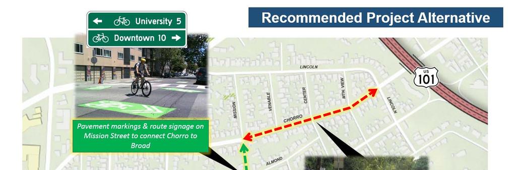
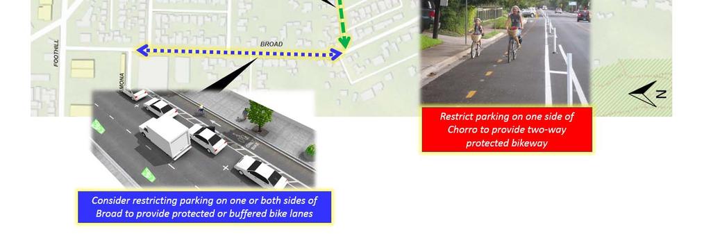
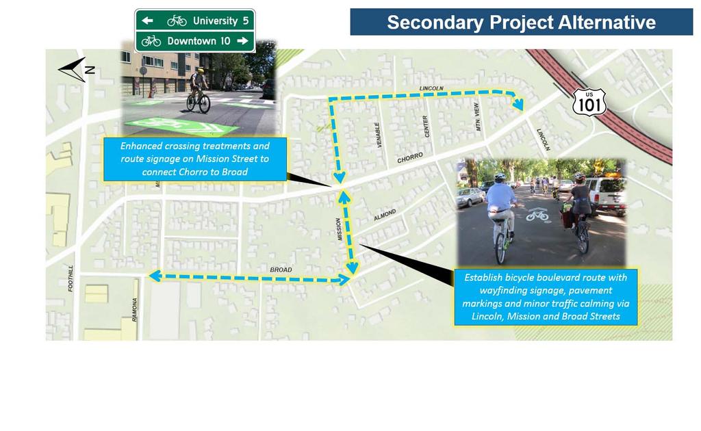
2 o o o Provide dedicated bicycle facilities on Chorro Street with removal of onstreet parking on one side of Chorro to provide width for a two-way protected bikeway from Lincoln to Mission. Route bicyclists from Chorro to Broad Street via Mission Street, using pavement markings and signage. No parking removal on Mission Street. Provide dedicated bicycle facilities on Broad Street from Mission to Ramona with removal of on-street parking on one or both sides of Broad to provide width for buffered or protected bicycle lanes. Consider a Secondary Alternative as a fallback option that limits removal of on-street parking: o o Establish a bicycle boulevard with treatments such as pavement markings, signage and low-impact traffic calming measures that require little-to-no modifications to traffic circulation or parking. The recommended route should utilize Lincoln Street parallel to Chorro north to Mission; Mission Street from Chorro to Broad; and Broad north of Mission to Ramona. For final alternatives, consider low-impact traffic calming elements, pedestrian crossing improvements and safety lighting enhancements that do not significantly impact circulation or parking to improve safety and neighborhood livability along Broad and Chorro Streets. Collect additional parking data once local schools and Cal Poly students return to session to further study existing on-street parking utilization and evaluate potential impacts associated with on-street parking removal, as proposed under the Recommended Alternative. Once the refined concepts are developed and analyzed, staff will present the updated plans to the public via an additional community meeting in fall of Staff will then return to the City Bicycle Advisory Committee and City Council for present the final plan for consideration, and potential adoption likely in early Meeting minutes from the August 15 th Council Study Session will be posted on the City s website when available. The primary features of the Recommended Alternative and Secondary Alternative are provided in Attachment A. A copy of the staff PowerPoint presentation is included in this document as Attachment B. Please visit the Project Website ( for past meeting summaries, project documents and meeting updates. Contact Project Managers Luke Schwartz (lschwartz@slocity.org) or Jennifer Rice (jrice@slocity.org) with any questions. 2
3 ATTACHMENT A
")


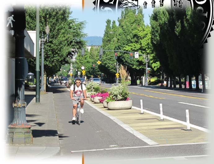
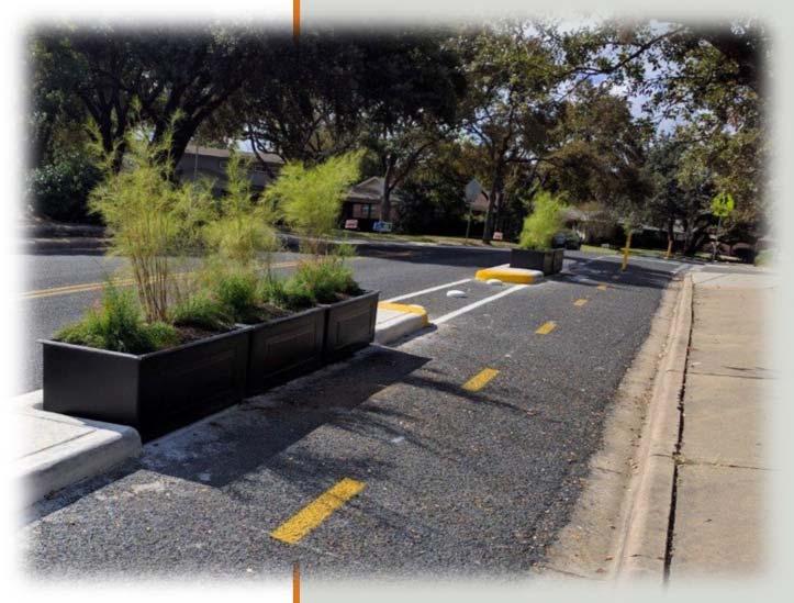
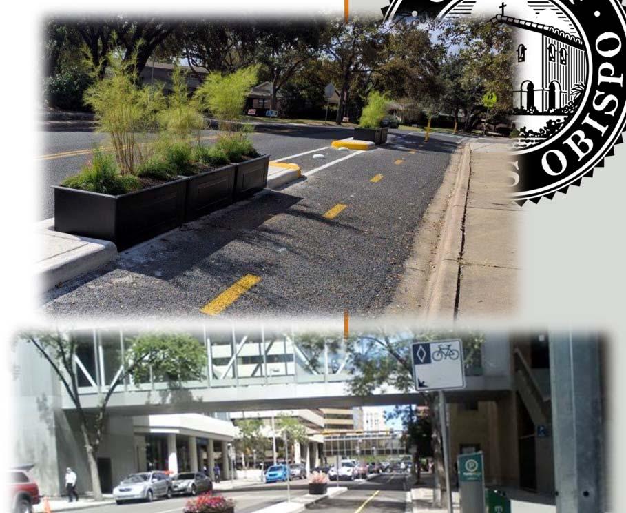
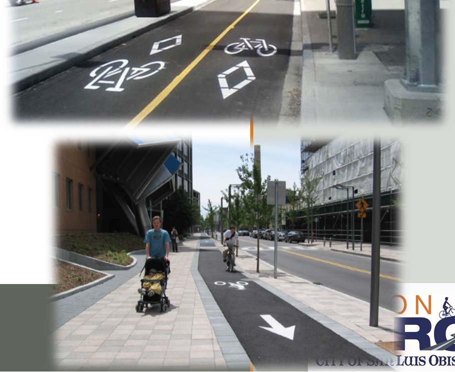
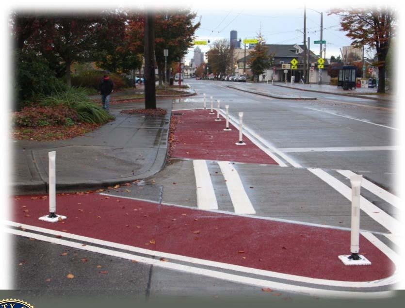
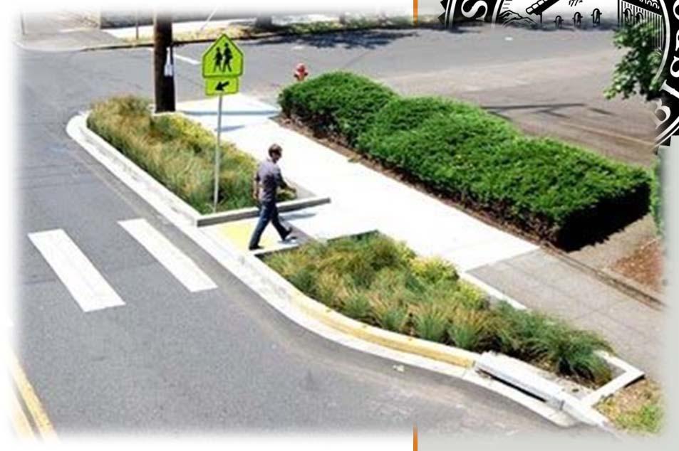
4 ATTACHMENT A Recommended Project Typical Cross Section: Chorro Street (Lincoln to Mission) Note: Form of physical protection between bicycle lanes and traffic lanes will be determined when project enters detailed design phase. Example treatments to be considered are illustrated below:
5 ATTACHMENT A Recommended Project Typical Cross Section: Mission Street (Chorro to Broad)
 Note:")

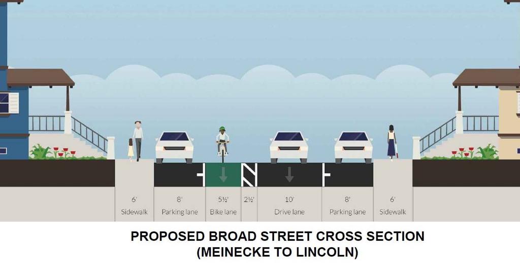
6 ATTACHMENT A Recommended Project Typical Cross Section: Broad Street (Mission to Meinecke) Note: Detailed parking studies to be conducted to guide selection of recommended configuration for Broad Street
7 ATTACHMENT A

8 ATTACHMENT A Secondary Alternative Typical Cross Section: Chorro/Lincoln/Broad Note: On street parking and travel lane widths remain as exist currently, with addition of pavement marking & signage. Broad Street section has narrower parking & travel lanes than shown in example graphic above.


 Discuss Other Project Options Community Feedback")
9 Broad Street Bicycle Boulevard Project Alternatives Study Session City Council, August 15 th, 2017 Presenters: Jake Hudson, Transportation Manager Luke Schwartz, Transportation Planner-Engineer Introductions & Background Present 3 Alternatives for Northern Segment (Lincoln to Ramona) Discuss Other Project Options Community Feedback Open Discussion


10 Focus Areas: Northern Segment Foothill to Hwy 101 Southern Segment Hwy 101 to Monterey Bike/Ped Crossing of Hwy 101


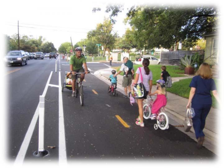
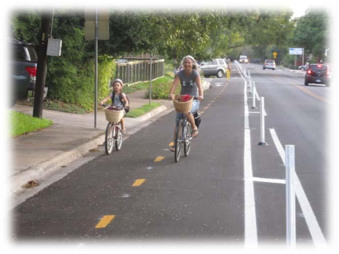
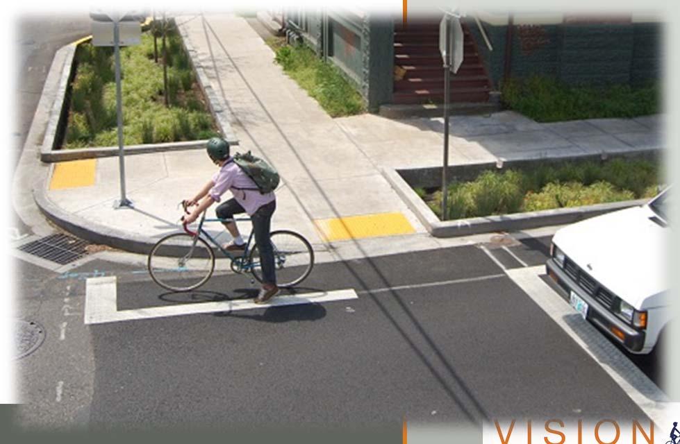
11 What is a Bicycle Boulevard & what makes a low-stress bicycle street? Bicycle Boulevard o Shared Street o Low auto volumes/speeds o Prioritizes bikes/peds, accommodates cars o Branded signs & pavement markings Low Stress Bicycling Environment o Separation from vehicle lanes o Low traffic volumes & speeds o Existing Broad/Chorro volumes & speeds exceed recommended levels for bike blvd. o Comfortable for users of varying ages & ability levels


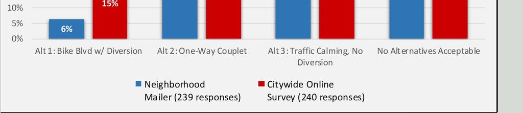
12 Public Outreach Activities 3 community meetings Including interactive design charrette 45 people attended each meeting Online Forum 1,000+ visitors to project site 120+ comments Community Survey Mailed to 1,200+ residents in project area 239 responses Online survey available community-wide 240 responses Social Media Platforms Press Releases City Website E-Blasts Tribune KSBY Neighborhood Mailers
13 Three Concept Alternatives Alternative 1: Bicycle boulevard with traffic diversion along Broad Street Alternative 2: One-way couplet : Broad southbound, Chorro northbound Alternative 3: Traffic calming on Broad and Chorro without traffic diversion *Final solution may be variant of these options or other strategies*


14 Alternative 1: Bicycle Boulevard with Traffic Diversion Along Broad PROS Significant speed reduction on Broad. Decreases traffic volume on Broad to provide a comfortable biking & pedestrian environment. Strong potential to establish a low-stress, convenient bicycle route on Broad. Can be installed for interim testing with lowcost temporary materials. Most favorable option for emergency response providers CONS With traffic diversion, increased traffic volumes on Chorro, Meinecke and Lincoln exceed established maximum neighborhood traffic thresholds. Less convenient access to properties on Broad. Degraded conditions for residents, drivers, bicyclists and pedestrians on Chorro with traffic diversion. Loss of on-street parking: 16 on Broad ; 0 on Chorro


15 Alternative 1: Bicycle Boulevard with Traffic Diversion Along Broad
16 Alternative 1: Bicycle Boulevard with Traffic Diversion Along Broad AVERAGE DAILY TRAFFIC VOLUME 12,000 10,000 8,000 6,000 4,000 2,000 0 SPEED AND VOLUME THRESHOLDS FOR SHARED BICYCLE STREET Maximum Preferred MAX NEIGHBORHOOD TRAFFIC THRESHOLD MOTOR VEHICLE SPEED (MPH) BROAD ST (ALT 1) CHORRO ST (ALT 1) CHORRO ST (EXISTING) BROAD ST (EXISTING)

17 Alternative 2: Broad/Chorro One-Way Couplet System PROS Moderate speed reduction on Broad. Traffic volumes more evenly distributed between Broad/Chorro. Bicycles fully separated from auto traffic. Significant potential to establish low-stress, convenient bicycle route for users of varying ages & ability levels. Most potential to attract new bicycle ridership. CONS Meinecke and Lincoln volumes exceed neighborhood traffic thresholds, although lower than with Alt. 1. Less convenient access to properties on Broad and Chorro. Higher cost & more challenging to test/install with interim treatments. Loss of on-street parking: 9 on Broad; 22 on Chorro. Least-desirable option for emergency response providers. Modifies primary response route Response time to DT increased by apx. 60 sec.; but not beyond minimum Limits use of ladder truck & available space for crew to operate in Expectation that Fire will occupy cycle track lanes during a response

18

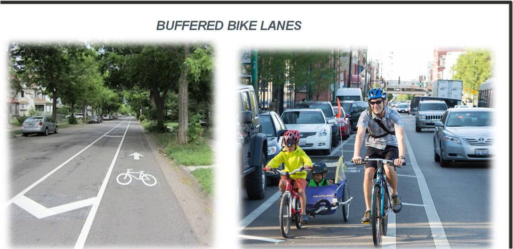
19 Alternative 2: Broad/Chorro One-Way Couplet System PROTECTED BIKEWAY (CYCLE TRACK) BUFFERED BIKE LANES

20 Alternative 3: Bicycle Boulevard with out Traffic Diversion on Broad Street PROS Significant speed reduction on Broad and moderate speed reduction on Chorro with traffic calming. No impact to circulation or property access. Moderate potential to establish a low-stress, convenient bicycle route on Broad Can be installed for interim testing with low-cost, temporary materials. Little impact to emergency response CONS Near-term volumes on Broad and Chorro remain above level for low-stress bicycle boulevard. Long-term closure of Highway 101 ramps would reduce Broad volumes into acceptable range, but timeframe TBD. No new impact, but Chorro volumes continue to exceed max neighborhood traffic thresholds. Loss of on-street parking: 20 on Broad ; 0 on Chorro. Least potential to attract new bicycle ridership.
21 Alternative 3: Bicycle Boulevard with out Traffic Diversion on Broad Street
22 Alternative 3: Bicycle Boulevard with out Traffic Diversion on Broad Street 12,000 SPEED AND VOLUME THRESHOLDS FOR SHARED BICYCLE STREET AVERAGE DAILY TRAFFIC VOLUME 10,000 8,000 6,000 4,000 2,000 Maximum Preferred CHORRO ST (ALT 3) MAX NEIGHBORHOOD TRAFFIC THRESHOLD BROAD ST (ALT 3) CHORRO ST (EXISTING) BROAD ST (EXISTING) MOTOR VEHICLE SPEED (MPH)


23 Other Variations Considered & Suggestions from Public Comment: On-Street Parking Removal on One Side of Chorro and/or Broad to provide protected bikeway in-lieu of one-way couplet conversion

 Way Protected Bikeway (Parking Removal One Side) Protected Bikeway (Parking")
24 Other Variations Considered & Suggestions from Public Comment: Example Chorro Street Two-Way Circulation with Protected Bikeway Example Broad Street Two-Way Circulation with One- Example Example Broad Broad Street Street Two-Way w/ Shared Circulation Lanes with (Existing) Way Protected Bikeway (Parking Removal One Side) Protected Bikeway (Parking Removal Both Sides)


25 Other Variations Considered & Suggestions from Public Comment: Lincoln Street Alignment 30+% longer trip Broad St
: Reverse couplet direction and/or reverse Broad one-way bike lane Align route so cyclists avoid")

26 Other Variations Considered & Suggestions from Public Comment: Pre-emptive Cut-Through Mitigation on Lincoln St. Alt 2. (One-Way Couplet): Reverse couplet direction and/or reverse Broad one-way bike lane Align route so cyclists avoid difficult uphill grades: Broad (NB Mountain View to Mission) Chorro (SB/NB approaching Murray & Meinecke) Replace existing speed humps on Broad w/ Speed Cushions Replace existing stop signs on Chorro w/ Traffic Circles Consideration for Aesthetics


27 Interim vs. Permanent Features


28 Interim vs. Permanent Features


29 Interim vs. Permanent Features
30 BAC Feedback SLO Bicycle Advisory Committee (BAC) received presentation and public input at 7/20 meeting. BAC deliberation focused on challenging balance between improving bicycling vs. neighborhood trade-offs Formal BAC recommendation to pursue Alternative 2 (Broad/Chorro One-Way Couplet) for further development to promote highest potential to increase bike safety & mode share

31 Community Feedback


32 Funding Included as CIP Project in Financial Plan FY2017/18 Phase 1 installation: $105k FY 2018/19 Phase 2 installation: $180k FY 2019/20 Phase 2 installation: $270k TOTAL $555k Funding Source: General Fund 36% from SB1 Transportation Funding 64% from General Capital Outlay
33 Where to Go From Here Council Study Session on Alternatives (8/15): Invite questions & additional public input Request Council guidance on preferred direction Plan Refinement Refine designs & analysis for preferred concept Prepare plan documenting process and final recommendations Final Community Meeting (4 th Quarter 2017) Present refined concept and analysis for preferred alternative Final Plan (early 2018) Present Final Plan to BAC & Council for adoption Phase 1 rollout 2018

34 Staff Recommendation: Receive presentation and public input on project alternatives; and Provide guidance to staff regarding Council s preferred alternative; and Direct staff to complete Broad Street Bicycle Plan.
CITY OF SLO SEEKS INPUT ON PREFERRED ALTERNATIVE FOR BROAD STREET BICYCLE BOULEVARD PROJECT
 City of San Luis Obispo, News Release DATE: August 1, 2017 RELEASE: Immediate CONTACT: Luke Schwartz (805) 781-7190 Transportation Planner-Engineer, Public Works CITY OF SLO SEEKS INPUT ON PREFERRED ALTERNATIVE
Anholm Bikeway Plan Planning Commission Meeting Summary (8/14/18)
") Anholm Bikeway Plan Planning Commission Meeting Summary (8/14/18) Overview: On August 14, 2018, the Planning Commission considered plans for the middle section of the Anholm Bikeway Plan, focusing on the
Anholm Bikeway Plan Planning Commission Meeting Summary (8/14/18) Overview: On August 14, 2018, the Planning Commission considered plans for the middle section of the Anholm Bikeway Plan, focusing on the
Community Design Charrette Meeting Summary
 Anholm Bikeway Plan Community Design Charrette (5/10/18) & Active Transportation Committee (5/17/18) Meeting Summaries (Lincoln St. to Ramona Dr. Plan Development) Community Design Charrette Meeting Summary
Broad Street Bicycle Boulevard Design Guidelines
 Broad Street Bicycle Boulevard Design Guidelines Building from the strategies introduced in the 2013 Bicycle Transportation Plan and community input received thus far, City Transportation Staff have identified
Lincoln Avenue Road Diet Trial
 Lincoln Avenue Road Diet Trial Data Collection Report June 1, 2015 Department of Transportation Table of Contents I. Introduction...... 3 II. Data Collection Methodology & Results...... 5 A. Traffic Volume
CITY OF OTTAWA ROADWAY MODIFICATION APPROVAL UNDER DELEGATED AUTHORITY
 RMA-2015-ATM-038 CITY OF OTTAWA ROADWAY MODIFICATION APPROVAL UNDER DELEGATED AUTHORITY DATE: April 22, 2015 SUBJECT Approval of Roadway Modifications Recommended through an Area Traffic Management Study
Welcome! San Jose Avenue Open House August 25, 2015
 Welcome! San Jose Avenue Open House August 25, 2015 Vision Zero The City and County of San Francisco adopted Vision Zero San Francisco Vision Zero High Injury Network as a policy in 2014, committing an
Northbound San Jose Avenue & I-280 Off-Ramp Road Diet Pilot Project
 Project Overview Fed by a two-lane Interstate-280 (I-280) off-ramp, high vehicular volumes and speeds are longstanding issues along San Jose Avenue. Residents in the surrounding neighborhoods have expressed
Monterey Road Complete Streets
 Monterey Road Complete Streets Complete Street Objectives Improve livability and economic vitality Enhance pedestrian environment Accommodate bicyclists safely Reduce noise and air pollution Create attractive,
Major Bike Routes 102 Avenue Workshop April 21, 2015
 Major Bike Routes 102 Avenue Workshop April 21, 2015 Our Purpose Today Provide context on how Major Bike Routes fit into Edmonton s future Share information on what we heard in our last phase, and how
SAN FRANCISCO MUNICIPAL TRANSPORTATION AGENCY
 THIS PRINT COVERS CALENDAR ITEM NO. : 11 DIVISION: Sustainable Streets BRIEF DESCRIPTION: SAN FRANCISCO MUNICIPAL TRANSPORTATION AGENCY Approving traffic modifications on Twin Peaks Boulevard between Christmas
Bikeway action plan. Bicycle Friendly Community Workshop March 5, 2007 Rochester, MN
 Bikeway action plan Summary The was held on March 5, 2007 at the Rochester Mayo Civic Center. The workshop was hosted by Rochester-Olmsted County Planning Department in collaboration with the League of
Outreach Approach RENEW SF served as the primary liaison with the North Beach community; the Chinatown. Executive Summary
 Executive Summary Executive Summary The Columbus Avenue Neighborhood Transportation Study s objective is to identify changes to transportation infrastructure and policies that could enhance the livability
Dr. M.L. King, Jr. Street North Complete Streets Resurfacing Opportunities HOUSING, LAND USE, AND TRANSPORTATION COMMITTEE MARCH 22, 2018
 Dr. M.L. King, Jr. Street North Complete Streets Resurfacing Opportunities HOUSING, LAND USE, AND TRANSPORTATION COMMITTEE MARCH 22, 2018 What s Happening The City plans to mill and resurface Dr. M.L.
REGIONAL BICYCLE AND PEDESTRIAN DESIGN GUIDELINES
 REGIONAL BICYCLE AND PEDESTRIAN DESIGN GUIDELINES November 16, 2011 Deb Humphreys North Central Texas Council of Governments Bicycle and Pedestrian Advisory Committee Snapshot of the Guide 1. Introduction
BETHEL ROAD AND SEDGWICK ROAD CORRIDOR STUDY
 DRAFT PLAN City Council Meeting August 14, 2017 STUDY AREA Sedgwick Corridor State Route 160, principal arterial with Class 3 access management designation, commuter and freight route, connection to SR
CITY OF LOS ANGELES INTER-DEPARTMENTAL MEMORANDUM
 CITY OF LOS ANGELES INTER-DEPARTMENTAL MEMORANDUM Date: April 1, 219 To: Honorable City Council c/o City Clerk, Room 395, City Hall Attention: Honorable Mike Bonin, Chair, Transportation Committee From:
Draft Traffic Calming Policy Paper
 Draft Traffic Calming Policy Paper What is Traffic Calming The term traffic calming is defined differently throughout the United States. The Institute of Transportation Engineers, an international educational
2014/2015 BIKE ROUTE PLAN 83 AVENUE PROTECTED BIKE LANE
 About the Project 2014/2015 BIKE ROUTE PLAN The City of Edmonton is planning a major bike route on the south side of Edmonton. This bike route is one part of a plan to provide citizens with transportation
Chapter 2. Bellingham Bicycle Master Plan Chapter 2: Policies and Actions
 Chapter 2 Bellingham Bicycle Master Plan Chapter 2: Policies and Actions Chapter 2: Policies and Actions The Bicycle Master Plan provides a road map for making bicycling in Bellingham a viable transportation
Welcome! Public Open House on UBC s Transportation Plan
 1 Welcome! Public Open House on UBC s Transportation Plan Public open house hours: to When it comes to on-campus transportation, what do you think is working well and what are some opportunities for improvement?
Cycle Track Design Best Practices Cycle Track Sections
 Design Best Practices Sections It is along street segments where the separation and protection methods of cycle tracks offer more comfort than conventional bicycle lanes, and are more attractive to a wide
City of Elizabeth City Neighborhood Traffic Calming Policy and Guidelines
 City of Elizabeth City Neighborhood Traffic Calming Policy and Guidelines I. Purpose: The City of Elizabeth City is committed to ensure the overall safety and livability of residential neighborhoods. One
Glebe Neighbourhood Cycling Plan
 Glebe Neighbourhood Cycling Plan Summary of Public Comments received after June 5 th Public Information Session Comment STUDY NETWORK CS9, CS8, E, E0 CS4, E CS4 CS8 E Suggestions for alternate cycling
County of Greenville South Carolina. Traffic Calming Program Neighborhood Traffic Education Program and Speed Hump Program
 County of Greenville South Carolina Traffic Calming Program Neighborhood Traffic Education Program and Speed Hump Program (rev) August 2008 I. PURPOSE The potential negative impacts from vehicular traffic
Bridgewater Complete Streets Prioritization Plan and Pedestrian Safety Assessment
 Bridgewater Complete Streets Prioritization Plan and Pedestrian Safety Assessment Presented by Luciano Rabito Manager of Complete Streets Presented to Bridgewater, MA Wednesday, April 26, 2017 6:30 P.M.
Living Streets Policy
 Living Streets Policy Introduction Living streets balance the needs of motorists, bicyclists, pedestrians and transit riders in ways that promote safety and convenience, enhance community identity, create
PROJECT OVERVIEW. 20th Avenue Project Limits (Lincoln Way to Wawona St)
") PROJECT OVERVIEW In 2014, San Francisco adopted Vision Zero as City policy, with a commitment to eliminate all traffic deaths in the City by 2024. nue Project Limits (Lincoln Way to St) Collision data
PROJECT OVERVIEW In 2014, San Francisco adopted Vision Zero as City policy, with a commitment to eliminate all traffic deaths in the City by 2024. nue Project Limits (Lincoln Way to St) Collision data
Ocean Park Boulevard Green Street Project Alternatives & Trade Offs
 Planning Commission March 4, 2009 Ocean Park Boulevard Green Street Project Alternatives & Trade Offs Purpose of Tonight s Meeting Review concept plans and options Provide input on alternatives and trade-offs
Lee s Summit Road Improvement Study Public Open House June 7, 2007 Summary of Comment Card Responses
 Lee s Summit Road Improvement Study Public Open House June 7, 2007 Summary of Comment Card Responses Introduction At the Lee s Summit Road Improvement Study Public Open House held Thursday, June 7, 2007
Capital Metro Downtown Multimodal Station
 Capital Metro Downtown Multimodal Station Open House December 11, 2015 Project Goals & Objectives 1 2 3 4 Address near- and long- term MetroRail operational needs Address existing safety issues and modal
Welcome. If you have any questions or comments on the project, please contact:
 Welcome This drop-in public open house is intended to provide information about the Bay Street bike lanes project. This project proposes a dedicated cycling facility along Bay Street between Aberdeen Avenue
Engineering - Bicycle and Pedestrian
 Capital Improvement Plan Project Summary # Bikeways Program 781,000 860,000 900,000 933,000 933,000 933,000 # Cannonball Path 1,200,000-780,000 - - - # Capital City Trail - 70,000 - - 910,000 - # Goodman
Los Altos Hills Town Council - June 18, 2015 Palo Alto City Council June 22, AGENDA ITEM #2.B Presentation
 Los Altos Hills Town Council - June 18, 2015 Palo Alto City Council June 22, 2015 AGENDA ITEM #2.B Presentation Previous Presentations Los Altos Hills Town Council in May 2014 and February 2015 Palo Alto
Ocean Park Boulevard Streetscape Improvement Project Alternatives & Trade Offs
 City Council Study Session January 27, 2009 Ocean Park Boulevard Streetscape Improvement Project Alternatives & Trade Offs Scope of Work Purpose of Tonight s Meeting Review work to date and direct staff
2014/2015 BIKE ROUTE PLAN 83 AVENUE PROTECTED BIKE LANE
 About the Project The City of Edmonton is planning a major bike route on the southside of Edmonton. The Strathcona Bike Route will connect the communities of Strathcona, Garneau and the University area,
» Draft Recommendations» Discussion» Next Steps. Plan for Walking and Biking
 SAC Meeting Plan #3 for September Walking and 12, Biking 2018 » Draft Recommendations» Discussion» Next Steps Plan for Walking and Biking » Stakeholder and Public Outreach» Background data collection and
MAG Town of Cave Creek Bike Study Task 6 Executive Summary and Regional Significance Report
 Page 1 MAG Town of Cave Creek Bike Study Task 6 Executive Summary and Regional Significance Report August 1, 2012 MAG Project #481 Page 2 Task 6 Executive Summary and Regional Significance Report Introduction
4. ENVIRONMENTAL IMPACT ANALYSIS 9. TRANSPORTATION AND TRAFFIC
 4. ENVIRONMENTAL IMPACT ANALYSIS 9. TRANSPORTATION AND TRAFFIC 4.9.1 INTRODUCTION The following section addresses the Proposed Project s impact on transportation and traffic based on the Traffic Study
Dowling/Beaty Cycling Route
 Public Meeting #2 Dowling/Beaty Cycling Route May 17, 2017 6:00 p.m. 8:00 p.m. Parkdale Public Library - Auditorium 1303 Queen Street West How to Participate Share your questions, ideas and concerns We
Main-McVay Transit Study: Phase 2 Options Definition and High Level Constraints Evaluation
 Main-McVay Transit Study: Phase 2 Options Definition and High Level Constraints Evaluation APRIL 2016 A collaborative study between: For Additional Information or to Comment If you would like additional
Bellevue Downtown Association Downtown Bike Series
 Bellevue Downtown Association Downtown Bike Series Meeting 2 Franz Loewenherz Andreas Piller Kyle Potuzak Chris Long October 26, 2017 Today s Agenda: 1) Meeting Purpose 2) 9/28 Meeting Recap 3) Candidate
RiNo Railroad Crossing Connectivity Analysis. Stakeholder Workshop June 29, 2017
 RiNo Railroad Crossing Connectivity Analysis Stakeholder Workshop June 29, 2017 Ideas and Considerations Presented at Stakeholder Workshop Primary Focus: 38 th Street (between Walnut & Wynkoop) 1 Basic
City of Vestavia Hills Traffic Calming Policy for Residential Streets
 City of Vestavia Hills Traffic Calming Policy for Residential Streets PURPOSE: The purpose of the Traffic Calming Policy for Residential Streets is to address safety concerns related to vehicular traffic
Pennsylvania Avenue (CR 484) Design Alternatives Study
 Design Alternatives Study") MEMORANDUM Pennsylvania Avenue (CR 484) Design Alternatives Study Prepared for: APRIL 2016 Prepared By TABLE OF CONTENTS Project Background... 2 Previous Concept... 2 Existing Conditions... 4 New Alternatives...
MEMORANDUM Pennsylvania Avenue (CR 484) Design Alternatives Study Prepared for: APRIL 2016 Prepared By TABLE OF CONTENTS Project Background... 2 Previous Concept... 2 Existing Conditions... 4 New Alternatives...
TRAFFIC ACTION PLAN. Laurie Meadows Neighborhood CITY OF SAN MATEO
 TRAFFIC ACTION PLAN Laurie Meadows Neighborhood CITY OF SAN MATEO Draft January 2017 Table of Contents Introduction... 2 The Traffic Forum Process... 5 Neighborhood Traffic Issues... 7 Neighborhood Recommendations
Traffic Calming Policy
 Article I. Purpose and Goal. The purpose of this policy is to establish criteria and procedures the City will use to evaluate requests for, and if appropriate, implement traffic calming measures. Neighborhood
City of Madison: 2017 Capital Budget Capital Improvement Plan
 Capital Improvement Plan Project Summary Bikeways Program 779,000 751,000 630,000 670,000 703,000 703,000 Cannonball Path 210,000 - - 730,000 - - Cap City Trail 1,140,000-360,000 - - 910,000 Ice Age Junction
FEDERAL HIGHWAY ADMINISTRATION APPLICATION
 FEDERAL HIGHWAY ADMINISTRATION APPLICATION REQUEST FOR PERMISSION TO EXPERIMENT WITH A BICYCLE BOX INTERSECTION TREATMENT Submitted by: City of Columbus Department of Public Service Date: June 26, 2009
City of Fairfax, Virginia City Council Work Session
 City of Fairfax, Virginia City Council Work Session Agenda Item # 4b City Council Meeting 6/2/2015 TO: FROM: SUBJECT: ISSUE(S): SUMMARY: FISCAL IMPACT: RECOMMENDATION: ALTERNATIVE COURSE OF ACTION: RESPONSIBLE
Kelowna On the Move. Pedestrian and Bicycle Master Plan
 Kelowna On the Move Pedestrian and Bicycle Master Plan Executive Summary April 2016 Purpose of the Plan The Pedestrian and Bicycle Master Plan identifies infrastructure, planning, and policy requirements
Chair and Members of Transportation Standing Committee. Bruce Zvaniga, P.Eng., Director, Transportation and Public Works
 P.O. Box 1749 Halifax, Nova Scotia B3J 3A5 Canada Item No. 12.1.1 Transportation Standing Committee December 7, 2017 TO: Chair and Members of Transportation Standing Committee SUBMITTED BY: ORIGINAL SIGNED
SAN FRANCISCO MUNICIPAL TRANSPORTATION AGENCY
 THIS PRINT COVERS CALENDAR ITEM NO.: 10.3 DIVISION: Sustainable Streets BRIEF DESCRIPTION: SAN FRANCISCO MUNICIPAL TRANSPORTATION AGENCY Approving various traffic and parking modifications on Bay Street
Simulation Analysis of Intersection Treatments for Cycle Tracks
 Abstract Simulation Analysis of Intersection Treatments for Cycle Tracks The increased use of cycle tracks also known as protected bike lanes has led to investigations of how to accommodate them at intersections.
Public Information Centre
 WELCOME Public Information Centre Father Tobin Road Lougheed Middle School - Library Wednesday November 7, 2012 7:00 p.m.to 9:00 p.m. Please sign in Neighbourhood Traffic Calming Guide Background The City
Safe Routes to School (SRTS) Improvements for Bishop s Peak & Pacheco Elementary Meeting #2 Summary
 Improvements for Bishop s Peak & Pacheco Elementary Meeting #2 Summary") Safe Routes to School (SRTS) Improvements for Bishop s Peak & Pacheco Elementary Meeting #2 Summary Overview. On March 8 th, 2017, community residents attended the second in a series of neighborhood meetings
Safe Routes to School (SRTS) Improvements for Bishop s Peak & Pacheco Elementary Meeting #2 Summary Overview. On March 8 th, 2017, community residents attended the second in a series of neighborhood meetings
Agenda. Overview PRINCE GEORGE S PLAZA METRO AREA PEDESTRIAN PLAN
 PRINCE GEORGE S PLAZA METRO AREA PEDESTRIAN PLAN May 28, 2008 Agenda Welcome and introductions Project overview and issue identification Planning context and strengths Design challenges and initial recommendations
PROPOSED BICYCLE AND PEDESTRIAN FACILITY Vicinity of Route 123/I-495 Interchange Tysons, Fairfax County, Virginia
 PROPOSED BICYCLE AND PEDESTRIAN FACILITY Vicinity of Route 123/I-495 Interchange Tysons, Fairfax County, Virginia PRELIMINARY ENGINEERING REPORT Prepared for: Prepared by: July 2017 Table of Contents 1
City of Seattle Edward B. Murray, Mayor
 City of Seattle Edward B. Murray, Mayor Department of Transportation Scott Kubly, Director Eastlake Community Council 117 E Louisa St. #1 Seattle, WA 98102-3278 January 28, 2016 RE: Roosevelt to Downtown
PRINCE GEORGE S PLAZA METRO AREA PEDESTRIAN PLAN
 PRINCE GEORGE S PLAZA METRO AREA PEDESTRIAN PLAN May 28, 2008 Agenda Welcome and introductions Project overview and issue identification Planning context and strengths Design challenges and initial recommendations
122 Avenue: 107 Street to Fort Road
 : 107 Street to Fort Road November 24, 2015 4:30 8:00 p.m. Meeting Purpose Summarize project work completed to date Share results of public input from Phase 1 Share the draft concept plan and proposed
Downey Road. Transportation Improvement Study
 Downey Road Transportation Improvement Study Workshop 2 Participant Handbook Workshop 1 May 18 and 19, 2016 Workshop 2 June 23 and 28, 2016 Prepared By: City of Guelph Paradigm Transportation Solutions
DEPARTMENT OF ENVIRONMENTAL SERVICES. North Harrison Street (Lee Highway to Little Falls Road) Comparative Analysis. Prepared for:
 Comparative Analysis. Prepared for:") DEPARTMENT OF ENVIRONMENTAL SERVICES North Harrison Street (Lee Highway to Little Falls Road) Comparative Analysis Prepared for: Arlington County Department of Environmental Services 2100 Clarendon Boulevard,
DEPARTMENT OF ENVIRONMENTAL SERVICES North Harrison Street (Lee Highway to Little Falls Road) Comparative Analysis Prepared for: Arlington County Department of Environmental Services 2100 Clarendon Boulevard,
University of Victoria Campus Cycling Plan Terms of Reference. 1.0 Project Description
 University of Victoria Campus Cycling Plan Terms of Reference 1.0 Project Description The Campus Cycling Plan, a first for the University, will provide a comprehensive and coordinated approach to support
SPEED MANAGEMENT FOR VISION ZERO
 SPEED MANAGEMENT FOR VISION ZERO LUANN HAMILTON, DEPUTY COMMISSIONER FOR PROJECT DEVELOPMENT CHICAGO DEPARTMENT OF TRANSPORTATION NACTO DESIGNING CITIES 2017 Vision Zero Action Plan Speed management and
Executive Summary Route 30 Corridor Master Plan
 Route Corridor Master Plan Project Overview The Route Corridor Master Plan is a coordinated multimodal transportation and land use plan for the entire stretch of Route through East Whiteland Township,
Item No Halifax Regional Council January 16, 2018 January 30, 2018
 P.O. Box 1749 Halifax, Nova Scotia B3J 3A5 Canada Item No. 9.2.1 Halifax Regional Council January 16, 2018 January 30, 2018 TO: Mayor Savage and Members of Halifax Regional Council Original Signed SUBMITTED
Reference number /VP. Lafayette Downtown Congestion Study - Additional Traffic Analysis
 To James Hinkamp and Tony Coe, City of Lafayette Date January 19, 2017 Copies Reference number 243381/VP From Michael Iswalt and Vanessa Peers File reference 4-05 Subject Lafayette Downtown Congestion
Town of Southwest Ranches Neighborhood Traffic Calming Program
 Town of Southwest Ranches The provides residents an opportunity to present a concern for traffic safety with respect to observed volume and speeds on neighborhood streets and a formal method to study and
WELCOME Public Information Centre
 WELCOME Public Information Centre Fernforest Drive Brampton Soccer Centre Community Room #2 Tuesday January 19, 2016 6:30 p.m.to 9:00 p.m. Please sign in Neighbourhood Traffic Calming Guide Background
HARRISON STREET/OAKLAND AVENUE COMMUNITY TRANSPORTATION PLAN
 HARRISON STREET/OAKLAND AVENUE Community Workshop #4: Draft Plan Review December 3, 2009 D E S I G N, C O M M U N I T Y & E N V I R O N M E N T INTRODUCTIONS Key Project Staff: Alisa Shen, Project Manager,
DRAFT - CITY OF MEDFORD TRANSPORTATION SYSTEM PLAN Roadway Cross-Sections
 Roadway Cross-Sections Medford s roadway cross-section standards apply to new and reconstructed roads. The crosssections take into consideration roadway function and operational characteristics, including
2018 Pedestrian and Bicycle and Safe Routes to School Application for Funding Page 1 of 31
 2018 Pedestrian and Bicycle and Safe Routes to School Application for Funding Page 1 of 31 2018 Pedestrian and Bicycle and Safe Routes to School Application for Funding Part 1: General Information Funding
Roundabouts and Bikes: Like Oil and Water or Peanut Butter and Bananas?
 Roundabouts and Bikes: Like Oil and Water or Peanut Butter and Bananas? 2017 APBP PDS Conference Memphis, Tennessee Alek Pochowski, AICP, PE Darren Buck June 27, 2017 Columbus Circle, New York City In
Outer Cape Bicycle & Pedestrian Master Plan. PUBLIC WORKSHOP #2 March 26, 2015
 Outer Cape Bicycle & Pedestrian Master Plan PUBLIC WORKSHOP #2 March 26, 2015 Introductions TODAY S DISCUSSION PRESENTATION: Project Background : Where have we been? Where are we now? Steering Committee
MTP BICYCLE ELEMENT UPDATE. November 2017
 MTP BICYCLE ELEMENT UPDATE November 2017 TIME FOR AN UPDATE Bicycle Element adopted in July 2008 Almost 10 years old Many planned facilities have been implemented 10 years more experience in planning,
FHWA Resources for Pedestrian and Bicycle Professionals
 FHWA Resources for Pedestrian and Bicycle Professionals Charlie Zegeer, UNC Highway Safety Research Center/PBIC Libby Thomas, UNC Highway Safety Research Center Dan Nabors, Vanasse Hangen Brustlin (VHB)
CITY OF MINNEAPOLIS 26 th St E/W & 28 th St E/W Protected Bikeway. Open House - February 2017
 CITY OF MINNEAPOLIS 26 th St E/W & 28 th St E/W Protected Bikeway Open House - February 2017 2/27/2017 1 Purpose of Meeting Inform: Provide an overview of the project Opportunity to gather feedback/input/observations
Borough of Danville, PA Traffic Calming Program Guidelines
 Borough of Danville, PA Traffic Calming Program Guidelines Adopted by Borough Council on 1 INTRODUCTION Speeding Traffic is a major concern in the Borough of Danville because of its detrimental impacts
BIKE PLAN CONTENTS GATEWAY
 CONTENTS Acknowledgments...vii Great Rivers Greenway District Board of Directors... vii Great Rivers Greenway District Staff... vii Project Consultants... vii Committees... viii Citizens Advisory Committee
UPTOWN REGIONAL BIKE CORRIDORS PROJECT SAN DIEGO ASSOCIATION OF GOVERNMENTS
 UPTOWN REGIONAL BIKE CORRIDORS PROJECT SAN DIEGO ASSOCIATION OF GOVERNMENTS SUMMARY REPORT: COMMUNITY UPDATE MEETING February 6, 2014 6 8:30 p.m. Roosevelt Middle School Library 3366 Park Blvd, San Diego
AGENDA REPORT. Issue: Discussion of potential improvements on Barnwell Road at Niblick Drive
 AGENDA REPORT To: From: By: Honorable Mayor and City Council Members Warren Hutmacher, City Manager Tom Black, Public Works Director Date: March 23, 2016 Agenda: March 28, 2016 WORK SESSION AGENDA: Barnwell
Display Boards Including Five Refined Design Concepts
 APPENDIX D Workshop Session 3 Sign-in sheets Agenda Booklet Display Boards Including Five Refined Design Concepts PowerPoint Presentation Questions Recorded Discussion of Preference Exercise AGENDA
City of Charlottesville Bicycle and Pedestrian Master Plan Update
 City of Charlottesville Bicycle and Pedestrian Master Plan Update September 17, 2014 I. Welcome and meeting overview II. Project status update III. Network overview IV. Break-out groups Pedestrian Network
Bicycle and Pedestrian Connectivity Study. Old Colony Planning Council
 Bicycle and Pedestrian Connectivity Study Old Colony Planning Council Outline Why consider bike/peds in road designs? Why are measures needed? Connecting Land Use with Transportation Evaluation Tools:
Vision: Traditional hamlet with an attractive business/pedestrian friendly main street connected to adjacent walkable neighborhoods
 N D. Focus Area II Vision: Traditional hamlet with an attractive business/pedestrian friendly main street connected to adjacent walkable neighborhoods Transit Road Focus Area II is located in the Hamlet
Washington Metropolitan Area Transit Authority Board Action/Information Summary. MEAD Number:
 Washington Metropolitan Area Transit Authority Board Action/Information Summary Action Information MEAD Number: 100962 Resolution: Yes No TITLE: Bicycle and Pedestrian Access Improvements Study PURPOSE:
Neighborhood Traffic Calming Policy & Guidelines
 Policy & Guidelines Town of Lantana 500 Greynolds Circle Lantana, FL 33462-4594 Index Topic Page Introduction 3 Definitions 4 Objectives 5 Policies 5 Process 6 Phases of Traffic Calming Study 7 Rating
Traffic Circulation Study for Neighborhood Southwest of Mockingbird Lane and Airline Road, Highland Park, Texas
 ARIZONA TEXAS NEW MEXICO OKLAHOMA February 13, 2015 Mr. Meran Dadgostar P.E., R.S. Town of Highland Park 4700 Drexel Dr. Highland Park, Texas 75205 Re: Traffic Circulation Study for Neighborhood Southwest
TRAFFIC CALMING GUIDE FOR TORONTO CITY OF TORONTO TRANSPORTATION SERVICES DIVISION
 TRAFFIC CALMING GUIDE FOR TORONTO CITY OF TORONTO TRANSPORTATION SERVICES DIVISION CITY OF TORONTO TRANSPORTATION SERVICES DIVISION 2016 TRAFFIC CALMING GUIDE FOR TORONTO TABLE OF CONTENTS Introduction
Chapter 4 TOOLBOX AND SAMPLE BIKE BOULEVARD LAYOUT
 Chapter 4 TOOLBOX AND SAMPLE BIKE BOULEVARD LAYOUT OVERVIEW This chapter describes a cohesive set of strategies to create a bicycle boulevard, namely to make streets safer and more efficient for bicycle
TRAFFIC ACTION PLAN. North Central Neighborhood CITY OF SAN MATEO
 TRAFFIC ACTION PLAN North Central Neighborhood CITY OF SAN MATEO Draft February 2017 Table of Contents Introduction... 1 The Traffic Forum Process... 4 Neighborhood Traffic Issues... 6 Neighborhood Recommendations
Bobbie Walthall. Hi Bobby, please include these comments in tonight s CC packet. Thanks for your consideration, Phil Collison Lawrence Resident
 Bobbie Walthall From: Sent: To: Subject: Phil Collison Tuesday, October 16, 2018 9:44 AM Bobbie Walthall Comments for Agenda item 3 Bike Boulevard Hi Bobby, please include these comments
Scottsdale Road/Rural Road Alternatives Analysis (AA) Study. Arizona ITE/IMSA Spring Conference March 7, 2012
 Study. Arizona ITE/IMSA Spring Conference March 7, 2012") Scottsdale Road/Rural Road Alternatives Analysis (AA) Study Arizona ITE/IMSA Spring Conference March 7, 2012 Study Location and Duration Primary Study Corridor (major focus of effort) Rural Road and Scottsdale
Scottsdale Road/Rural Road Alternatives Analysis (AA) Study Arizona ITE/IMSA Spring Conference March 7, 2012 Study Location and Duration Primary Study Corridor (major focus of effort) Rural Road and Scottsdale
Proposed White Flint Separated Bike Lane Network September 2015
 Proposed White Flint Separated Bike Lane Network September 2015 Abstract This report includes a proposed separated bike lane network for the White Flint Sector Plan area. Separated bike lanes create a
Watertown Complete Streets Prioritization Plan. Public Meeting #1 December 14, 2017
 Watertown Complete Streets Prioritization Plan Public Meeting #1 December 14, 2017 Goals for Public Meeting Overview of MassDOT Complete Streets Funding Program Educate the community on Complete Streets
Laurier Segregated Bike Lane Pilot Project July 2013 update
 Laurier Segregated Bike Lane Pilot Project July 2013 update Presentation Overview Background Pilot Monitoring Results Mitigation Recommendations Next Steps Laurier 2 Background Laurier Avenue Segregated
EXECUTIVE SUMMARY. Vision
 Vision Walking and bicycling in Salt Lake City will be safe, convenient, comfortable, and viable transportation options that connect people to places, foster recreational and economic development opportunities,
City of Wilsonville 5 th Street to Kinsman Road Extension Project
 City of Wilsonville 5 th Street to Kinsman Road Walking Tour & Neighborhood Workshop Summary Report Public Outreach Overview On July 18 th, 2017, the City of Wilsonville hosted a neighborhood walking tour
North Shore Transportation Improvement Strategy
 North Shore Transportation Improvement Strategy Preliminary, Near-term Recommendation 2016 April Transportation Improvement Strategy (TIS) Comprehensive and Analytical A multi-modal transportation strategy