Samish-Maple-Ellis Corridor Pedestrian & Bicycle Safety Improvements. Bellingham City Council March 26, 2018
|
|
|
- Robyn Montgomery
- 5 years ago
- Views:
Transcription
1 1 Samish-Maple-Ellis Corridor Pedestrian & Bicycle Safety Improvements Bellingham City Council March 26, 2018

2 2009 Samish Way Urban Village Street Plans Multiple Plans Adopted by City Council 2009 Samish Way Urban Village Plan 2012 Citywide Pedestrian Master Plan 2014 Citywide Bicycle Master Plan Conflicting Recommendations for Samish Way Samish UV Plan: On-street parking both sides - 3-lanes + bike lanes + parking = 62-feet street width - Would require widening by 3-feet minimum each side Ped Plan: Additional, shorter crossings - 3 constructed ( ) Abbott, Consolidation, Newell - 4 th to be constructed at Otis in summer 2018 Bike Plan: Bike lanes & Further Study Needed - Samish-Maple-Ellis Corridor Study ( ) - Proposed 5-to-3-lane road diet + buffered bike lanes 2
3 3
4 4

5 Samish-Maple-Ellis Corridor Study


6 6 Who Are We Planning For? GOAL T-2 Provide safe, well-connected, and sustainable mobility options for all users. Policy T-5 Connect missing links within the Citywide multimodal transportation network for all modes of transportation, including pedestrian, bicycle, transit bus, freight trucks, and private automobiles. Policy T-6 Design multimodal transportation improvements on existing and new streets with the safety and mobility needs of all user groups considered and with priority emphasis placed on the most vulnerable user groups, as illustrated BALANCE: All mobility needs for all modes must be carefully considered, balanced, and implemented so that the citywide multimodal transportation system continues to work for everyone. Youth (WWU & school kids) Families Senior citizens Physically challenged Low-income Racial and Ethnic Diversity Urban Village infill development Bike Network Connectivity All Ages and Abilities
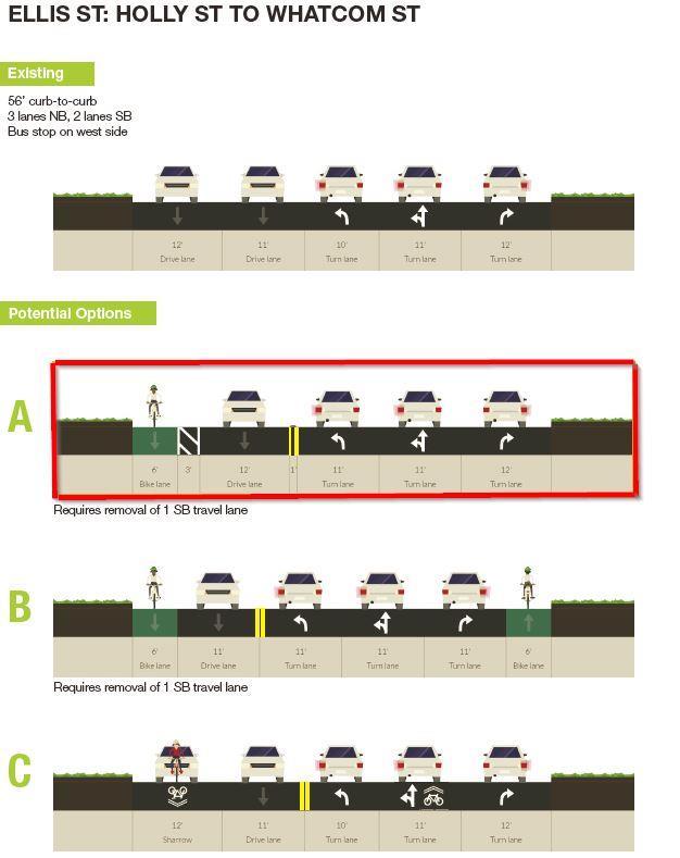
 mile Five 11 vehicle lanes 56 feet curb to curb 5 sidewalks full length No bike facilities Pedestrian-activated amber flashing crosswalks at Abbott, Consolidation, and")
7 N. Samish Way Existing Conditions Bill McDonald to Lakeway Length = 0.77 (3/4) mile Five 11 vehicle lanes 56 feet curb to curb 5 sidewalks full length No bike facilities Pedestrian-activated amber flashing crosswalks at Abbott, Consolidation, and Newell ( ) Posted 35 mph speed limit Traffic volumes vary from 13,000 to 15,000 vehicles per day 7


8 Bellingham Housing Authority Proposal 160 low-income and senior apartments + 11,000 SF BHA offices on former Aloha Motel site between Abbott and Otis Funding being sought 8

9 Corridor Segment 1 9

10 Corridor Segment 2 10

11 Corridor Segment 3 11


12 Alternative Bike Blvd & Possible New Crossing 12
 Construction summer")
13 13 Conceptual Layout New pedestrianactivated flashing amber crosswalk at Samish/Otis intersection Between Boomer s and future Bellingham Housing Authority Aloha Site (160 low-income & senior citizen apartments) Construction summer 2018

14 Corridor Segment 4 14

15 Corridor Segment 5a 15

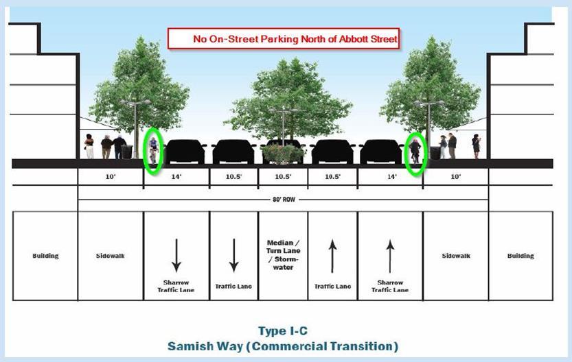
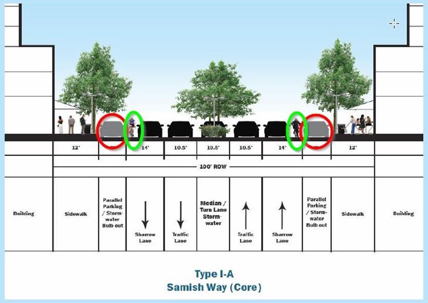
16 Corridor Segment 5 Transition Area Buffered Bike Lane on East Side Helps Create Transition from 5-Lanes to 3- Lanes north of the Walgreen s Driveway Green Dashed Lines Across Driveways on Both Sides Alert Drivers to Presence of Bike Lane and Bicyclists Crossing (Ex. W. Maplewood & Alderwood) Solid Green Bike Lanes are used in the Midst of Vehicle Lanes to Alert Drivers to the Presence of Bicyclists and Dedicated Bike Space Bike Lanes Continued Through Intersections with Green Dashed Boxes 16

17 Corridor Segment 5b 17
18 What Has Happened So Far Samish-Maple-Ellis Corridor Study (Oct 2016 May 2017) Many Presentations to Community Groups Transportation Commission (April 11, 2017) Mayor s City Center Staff (May 2, 2017) Bellingham Housing Authority (May 5, 2017) Sehome Neighborhood Meeting (May 23, 2017) Samish-Maple-Ellis adopted in TIP (June 5, 2017) Program & fund Otis/Maple crossing improvements for 2018 Local funds added to WSDOT Lakeway-Lincoln Ped-Bike Safety grant York Neighborhood Meeting (June 14, 2017 & March 14, 2018) Puget Neighborhood Meeting (February 20, 2018) 18
19 What Happens Next? 19 Began work with businesses at Otis/Maple and along Samish corridor Access, parking, and design issues ( ) Refined Cost Estimates for Otis/Maple intersection (2017) $413,000 TIB Sidewalk grant secured for $250,000 to reconstruct Otis/Maple, install flashing crosswalk Refining Cost Estimates for Samish-Maple-Ellis corridor ( ) Between $2,000,000 to $2,500,000, depending on what s included Identify possible transportation grant funding sources ( ) Apply for WSDOT Ped-Bike Safety grant funding (May 2018) WSDOT Ranked Project List/Recommendation for Funding December 2018 IF funded by State legislature, then WSDOT notice of funding in May/June 2019 Reconstruct Otis/Maple intersection (Summer 2018) Curb extensions, driveway access, bike blvd crossing Install relocated Lakeway/Grant amber flashing crosswalk IF WSDOT ped-bike safety grant funding is secured in June 2019 PE/Design could occur autumn-winter 2019 THEN Construction could occur summer 2020
 New HAWK signal on Lakeway - west side Undine intersection Consolidate/relocate WTA bus shelters to be at HAWK crossing New")
20 2018 Lakeway-Lincoln Improvements Upgrade 3 flashing amber crossings to red HAWK signals Lakeway/Grant Lakeway/Orleans Lincoln/Fred Meyer Shift north to align with WTA transit shelters and to provide space for future HAWKs on Lincoln Street (pending future grant funding) New HAWK signal on Lakeway - west side Undine intersection Consolidate/relocate WTA bus shelters to be at HAWK crossing New amber flashing crosswalk at Samish-Maple-Otis Supports future BHA redevelopment of former Aloha Motel site into 160 low-income apartments and 11,000 SF office space for BHA Bike lane on Puget Street and green bike box at Puget/Lakeway Bike lane on Lakeway Drive from Undine HAWK to Queen St Sidewalk on Orleans (west side) from Lakeway to Potter St Sidewalk on Nevada (east side) from Whatcom to Thimbleberry Nevada-Byron-40 th Bike Boulevard from Lakeway to Elwood Ave Includes physical traffic calming Grant-Humboldt-34 th Bike Boulevard from Meador to Bill McDonald Connects to bike lanes on Bill McDonald Pkwy 20

21 What is a HAWK signal? High Intensity Activated Crosswalk (Technically known as a Pedestrian Hybrid Beacon ) 21

22 Public Works Plan for Short-Term ( ) and Long-Term (2021+) Connectivity of Pedestrian & Bicycle Facilities between Puget Neighborhood and Downtown Bellingham 22
23 For Questions or More Information Chris Comeau, AICP-CTP, Transportation Planner (360) or 23
2018 Pedestrian and Bicycle and Safe Routes to School Application for Funding Page 1 of 31
 2018 Pedestrian and Bicycle and Safe Routes to School Application for Funding Page 1 of 31 2018 Pedestrian and Bicycle and Safe Routes to School Application for Funding Part 1: General Information Funding
Changing the Climate of Mobility: Bellingham s Multimodal Transportation Networks
 1 Changing the Climate of Mobility: Bellingham s Multimodal Transportation Networks Presented by: Chris Comeau, Transportation Planner, Public Works Climate Action Task Force March 6, 2019 2 Bellingham
Transportation Report on Annual Mobility
 Transportation Report on Annual Mobility Published annually in support of: Comprehensive Plan Transportation Element Multimodal Transportation Concurrency Program Transportation Benefit District No. 1
Transportation Report on Annual Mobility
 Transportation Report on Annual Mobility Published annually in support of: Comprehensive Plan Transportation Element Multimodal Transportation Concurrency Program Transportation Benefit District No. 1
Multi-Modal Transportation Improvement Projects Identified by Neighborhood for the 20-year Planning Period
 2011 CITY CENTER MASTER PLAN UPDATE ADOPTED TRANSPORTATION ELEMENT PROJECT LIST FOR THE CBD, WATERFRONT, AND YORK, SEHOME, AND LETTERED STREETS NEIGHBORHOODS IMMEDIATELY ADJACENT TO CITY CENTER TRANSPORTATION
Omaha s Complete Streets Policy
 Omaha s Complete Streets Policy (Adopted August 2015) VISION To create great places and enhance our quality of life, the City of Omaha will provide safe, accessible streets for all users. Complete Streets
Supplemental Information for DRAFT TIP
 City of Bellingham Public Works Department Supplemental Information for DRAFT 2016-2021 TIP The following pages are intended to provide supplemental information and explanation of the rationale for projects
Alabama Street Corridor. Road Diet Feasibility Study & Safety Improvements
 Alabama Street Corridor Road Diet Feasibility Study & Safety Improvements Chris Comeau, AICP, Transportation Planner Bellingham Public Works (360) 778-7946 10/28/2011 Bellingham adhered to the following
Transportation Report on Annual Mobility
 Transportation Report on Annual Mobility Published annually in support of Bellingham s: Comprehensive Plan Transportation Element; Multimodal Transportation Concurrency Program; Complete Networks Policies;
Six-Year ( ) Transportation Improvement Program (TIP)
 Transportation Improvement Program (TIP)") Six-Year (2018-2023) Transportation Improvement Program (TIP) Kelli Linville, Mayor Ted Carlson, Public Works Director City Council Members Michael Lilliquist 6th Ward, Council President Roxanne Murphy
Six-Year (2018-2023) Transportation Improvement Program (TIP) Kelli Linville, Mayor Ted Carlson, Public Works Director City Council Members Michael Lilliquist 6th Ward, Council President Roxanne Murphy
Telegraph Avenue Complete Streets DRAFT Recommendations. Oakland Public Works Department September 11 and 13, 2014 Open Houses
 Telegraph Avenue Complete Streets DRAFT Recommendations Oakland Public Works Department September 11 and 13, 2014 Open Houses Presentation Overview What are complete streets? What problem are we trying
Chapter 2. Bellingham Bicycle Master Plan Chapter 2: Policies and Actions
 Chapter 2 Bellingham Bicycle Master Plan Chapter 2: Policies and Actions Chapter 2: Policies and Actions The Bicycle Master Plan provides a road map for making bicycling in Bellingham a viable transportation
UNIVERSITY RIDGE STUDENT HOUSING
 Transportation Impact Analysis UNIVERSITY RIDGE STUDENT HOUSING Prepared for: Ronald T. Jepson & Associates, PS April 213 Prepared by: 1173 118 th Avenue NE, Suite 6 Kirkland, WA 9834-712 Phone: 425-821-3665
In November 2015, the City of Bellingham, WA, USA completed $4.3 million in safety
 CASE STUDY C-Curb Your Enthusiasm: By Chris Comeau, AICP-CTP and Chris Breiland In November 2015, the City of Bellingham, WA, USA completed $4.3 million in safety improvements on Alabama Street using the
Transportation Planning Division
 Transportation Planning Division Presentation Outline Study Tasks Recap of Previous Meetings Data Collected Focus Areas within Study Limits Design Principles Tool Box Recommended Concepts Schedule Moving
Road Diets FDOT Process
 Florida Department of TRANSPORTATION Road Diets FDOT Process Humberto Castillero, PE, PTOE Roadway Design Office Purpose of Guide Develop a statewide lane elimination review process Balance state & local
BETHEL ROAD AND SEDGWICK ROAD CORRIDOR STUDY
 DRAFT PLAN City Council Meeting August 14, 2017 STUDY AREA Sedgwick Corridor State Route 160, principal arterial with Class 3 access management designation, commuter and freight route, connection to SR
Chapter 2: Standards for Access, Non-Motorized, and Transit
 Standards for Access, Non-Motorized, and Transit Chapter 2: Standards for Access, Non-Motorized, and Transit The Washtenaw County Access Management Plan was developed based on the analysis of existing
Pine Hills Road Pedestrian/Bicycle Safety Study Board of County Commissioners Work Session
 Pine Hills Road Pedestrian/Bicycle Safety Study Board of County Commissioners Work Session February 20, 2018 Meeting Agenda Study Overview Existing Conditions Access Management Potential Gateway Features
Citywide Sidewalk and Crosswalk Programs
 Citywide Sidewalk and Crosswalk Programs Council Meeting October 20, 2015 Presented by Rita Hu and Jamal Mahmoud Program Goals Implement the City s comprehensive plan. Provide pedestrian with safe walking
North Avenue Corridor Study
 North Avenue Corridor Study City Council October 6, 2014 Presentation Outline Project Initiation & Process Corridor Conditions & Issues Vision & Goals Concept Development - Development/Evaluation Implementation
Bicycle Facilities Planning
 Bicycle Facilities Planning Overview Types of Cyclists Purpose for Riding Types of Facilities Bike Lanes Bicycle Boulevards Cycle Tracks Intersections Signals Signing and Marking Discussion Types of Bicyclists
C C C
 C-012-001 Thank you for your support for the creation of new public space and nonmotorized access between downtown and the waterfront through the Overlook Walk, the East-West Connections, and the Promenade.
ROAD SAFETY AUDIT (RSA) Barbur Blvd: SW Capitol Hwy to SW Naito Parkway (M.P to M.P. 1.95)
 Barbur Blvd: SW Capitol Hwy to SW Naito Parkway (M.P to M.P. 1.95)") ROAD SAFETY AUDIT (RSA) Barbur Blvd: SW Capitol Hwy to SW Naito Parkway (M.P. 6.30 to M.P. 1.95) SWNI Meeting November July 18, 2016 19, 2015 Portland, Oregon BARBUR ROAD SAFETY AUDIT FHWA RSA Process
ROAD SAFETY AUDIT (RSA) Barbur Blvd: SW Capitol Hwy to SW Naito Parkway (M.P. 6.30 to M.P. 1.95) SWNI Meeting November July 18, 2016 19, 2015 Portland, Oregon BARBUR ROAD SAFETY AUDIT FHWA RSA Process
Six-Year ( ) Transportation Improvement Program (TIP)
 Transportation Improvement Program (TIP)") Six-Year (2017-2022) Transportation Improvement Program (TIP) Kelli Linville, Mayor Ted Carlson, Public Works Director City Council Members Pinky Vargas - 4th Ward, Council President Roxanne Murphy - At
Six-Year (2017-2022) Transportation Improvement Program (TIP) Kelli Linville, Mayor Ted Carlson, Public Works Director City Council Members Pinky Vargas - 4th Ward, Council President Roxanne Murphy - At
San Jose Transportation Policy
 San Jose Transportation Policy Protected Intersections in LOS Policies to Support Smart Growth Presented by: Manuel Pineda City of San Jose Department of Transportation Bay Area Map San Francisco Oakland
PEDESTRIAN ACTION PLAN
 CITY OF SANTA MONICA PEDESTRIAN ACTION PLAN DRAFT OCTOBER 2015 City Council, February 23, 2016 Beth Rolandson, AICP Principal Transportation Planner Mobility Division, Planning and Community Development
Chapter 3: Bicycle Network Recommendations
 Chapter 3: Bicycle Network Recommendations Chapter 3 presents the recommended network of on-street bicycle facilities that will help Bellingham meet the goals of this Plan. It describes the methodology
PEDESTRIAN ACTION PLAN
 CITY OF SANTA MONICA PEDESTRIAN ACTION PLAN DRAFT OCTOBER 2015 Safe Streets Santa Monica, December 3, 2015 Beth Rolandson, AICP Principal Transportation Planner Strategic + Transportation Planning, Planning
Columbia Pike Implementation Team (CPIT) Meeting
 Meeting") Columbia Pike Implementation Team (CPIT) Meeting November 30, 2010 Agenda Introductions / Purpose of Meeting Review of project goals Multimodal project: 10% street design between the curbs Discussion Multimodal
Columbia Pike Implementation Team (CPIT) Meeting November 30, 2010 Agenda Introductions / Purpose of Meeting Review of project goals Multimodal project: 10% street design between the curbs Discussion Multimodal
Southside Pilot Proposal
 To improve bicycle access and mobility to UC Berkeley, Downtown Berkeley, and the Southside area, a pilot project could include a two-way parking-protected cycle track. Turn pockets and island bus stops
City of Birmingham Draft Multi-modal Transportation Plan
 City of Birmingham Draft Multi-modal Transportation Plan City Commission Public Hearing Monday, November 25, 2013 7:30 pm Norman Cox, PLA, ASLA The Greenway Collaborative, Inc. Ann Arbor, Michigan The
Agenda. Overview PRINCE GEORGE S PLAZA METRO AREA PEDESTRIAN PLAN
 PRINCE GEORGE S PLAZA METRO AREA PEDESTRIAN PLAN May 28, 2008 Agenda Welcome and introductions Project overview and issue identification Planning context and strengths Design challenges and initial recommendations
APPENDIX A: Complete Streets Checklist DRAFT NOVEMBER 2016
 APPENDIX A: Complete Streets Checklist DRAFT NOVEMBER 2016 Complete Streets Checklist MetroPlan Orlando s Complete Streets Checklist is an internal planning tool for staff to further implementation of
Project Team. Refined Pedestrian Crossing Toolbox. Problem Statement. Aerial of Study Corridor. Crossing Accommodations and Pedestrian Fatalities
 Project Team Refined Pedestrian Crossing Toolbox Treatments on Wide, High Speed Urban Roadways Developed as Part of the Springfield Main Street (OR 126) Safety Study Consultants Scott Mansur, P.E., P.T.O.E.
Duwamish Way-finding and CTR Report
 V. North Tukwila When the North Tukwila Manufacturing and Industrial Center was designated in 1992 as part of the region s land use and transportation plan, the plan called for the area to set a light-rail
In station areas, new pedestrian links can increase network connectivity and provide direct access to stations.
 The Last Mile Planning for Pedestrians Planning around stations will put pedestrians first. Making walking to stations safe and easy is important; walking will be a part of every rapid transit Accessible
Rightsizing Streets: The Seattle Experience
 Rightsizing Streets: The Seattle Experience April 30, 2013 Brian Dougherty Seattle Department of Transportation Complete Streets 16% of households do not have a car Seniors Youth Transit riders Safety
Governance and Priorities Committee Report For the July 2, 2015 Meeting
 CITY OF VICTORIA For the July 2, 2015 Meeting To: Governance and Priorities Committee Date: From: Subject: Brad Dellebuur, A/Assistant Director, Transportation and Parking Services Executive Summary The
PRINCE GEORGE S PLAZA METRO AREA PEDESTRIAN PLAN
 PRINCE GEORGE S PLAZA METRO AREA PEDESTRIAN PLAN May 28, 2008 Agenda Welcome and introductions Project overview and issue identification Planning context and strengths Design challenges and initial recommendations
El Camino Real Specific Plan. TAC/CAC Meeting #2 Aug 1, 2018
 El Camino Real Specific Plan TAC/CAC Meeting #2 Aug 1, 2018 Land Use Alternatives Goals and Tradeoffs Parks & open space Housing Retail & services Civic spaces Parking Community gathering spaces 3 Alternatives
Dec 2, Dear Tri Ong, Sam Woods, and Scott Kubly,
 Dec 2, 2014 Dear Tri Ong, Sam Woods, and Scott Kubly, Thank you for providing us with the 2015 Arterial Asphalt and Concrete (AAC) repaving project 60% plan for Roosevelt Way NE. It's exciting to see the
9/25/2018. Multi-Modal Level of Service (MMLOS) Bianca Popescu, Transportation Planner
 Bianca Popescu, Transportation Planner") Multi-Modal Level of Service (MMLOS) Bianca Popescu, Transportation Planner 1 What is MMLOS? Is this a nice place to walk? Is this a nice place to bike? Is transit convenient? Bottom line - Are there options
Multi-Modal Level of Service (MMLOS) Bianca Popescu, Transportation Planner 1 What is MMLOS? Is this a nice place to walk? Is this a nice place to bike? Is transit convenient? Bottom line - Are there options
Watertown Complete Streets Prioritization Plan. Public Meeting #1 December 14, 2017
 Watertown Complete Streets Prioritization Plan Public Meeting #1 December 14, 2017 Goals for Public Meeting Overview of MassDOT Complete Streets Funding Program Educate the community on Complete Streets
SR-203 Sidewalks and Town-Wide Mobility Improvements. Town Council Presentation September 7, 2016
 SR-203 Sidewalks and Town-Wide Mobility Improvements Town Council Presentation September 7, 2016 SR-203 Sidewalks and Town- Wide Mobility Improvements SR-203 Sidewalks and Appurtenances Town-Wide Mobility
Bicycle and Pedestrian Advisory Committee (BPAC) November 21, 2013
 November 21, 2013") Bicycle and Pedestrian Advisory Committee (BPAC) November 21, 2013 OVERALL LAND USE CONCEPT Overall Broadway Valdez District: 95.5 acres (35.1 acres right-of ways + 60.4 acres developable land) Plan Subareas:
Bicycle and Pedestrian Advisory Committee (BPAC) November 21, 2013 OVERALL LAND USE CONCEPT Overall Broadway Valdez District: 95.5 acres (35.1 acres right-of ways + 60.4 acres developable land) Plan Subareas:
Balancing Operation & Safety for Motorized and Non-Motorized Traffic
 Balancing Operation & Safety for Motorized and Non-Motorized Traffic Brian Willham, PE, PTOE Iowa Director - MOVITE June 30, 2014 Learning Objectives: When & Why should we measure the performance of complete
CONNECTING PEOPLE TO PLACES
 CONNECTING PEOPLE TO PLACES 82 EAST BENCH MASTER PLAN 07 Introduction The East Bench transportation system is a collection of slow moving, treelined residential streets and major arteries that are the
North Avenue Corridor Study
 North Avenue Corridor Study Transportation, Energy and Utilities Committee September 10, 2014 Presentation Outline Project Initiation: Why North Avenue? Existing Conditions + Issues Vision + Goals Improvement
City of Sammamish. Welcome. Issaquah-Fall City Road Improvements Project Phase I Design: 242nd Avenue SE to Klahanie Drive SE
 Welcome Welcome to the third community meeting for the Issaquah-Fall City Road Improvements Project. AGENDA 6:00 p.m. Welcome and sign-in 6:10 p.m. Presentation 6:50 p.m. Open house Learn about the roadway
TRAFFIC ACTION PLAN. North Central Neighborhood CITY OF SAN MATEO
 TRAFFIC ACTION PLAN North Central Neighborhood CITY OF SAN MATEO Draft February 2017 Table of Contents Introduction... 1 The Traffic Forum Process... 4 Neighborhood Traffic Issues... 6 Neighborhood Recommendations
Active Transportation Facility Glossary
 Active Transportation Facility Glossary This document defines different active transportation facilities and suggests appropriate corridor types. Click on a facility type to jump to its definition. Bike
Environment and Public Works Committee Presentation
 Mixed Use Centers Complete Streets Guidelines Project Environment and Public Works Committee Presentation December 10, 2008 Project Objectives: Conduct an inter-departmental and agency process to study
Multimodal Analysis in the 2010 Highway Capacity Manual
 Multimodal Analysis in the 2010 Highway Capacity Manual It s not just cars anymore! Jamie Parks, AICP HCAT Conference May 9-10, 2011 Multimodal LOS in the 2010 HCM History and background Overview of methods
Houma-Thibodaux Metropolitan Planning Organization STP<200K Funding Application APPLICATION
 APPLICATION HOUMA-THIBODAUX METROPOLITAN PLANNING ORGANIZATION (HTMPO) FOR SURFACE TRANSPORTATION PROGRAM (STP
Item No. 14 Town of Atherton
 Item No. 14 Town of Atherton CITY COUNCIL STAFF REPORT CONSENT AGENDA TO: THROUGH: FROM: HONORABLE MAYOR AND CITY COUNCIL GEORGE RODERICKS, CITY MANAGER MICHAEL KASHIWAGI, COMMUNITY SERVICES DIRECTOR MARTY
Broad Street Bicycle Boulevard Design Guidelines
 Broad Street Bicycle Boulevard Design Guidelines Building from the strategies introduced in the 2013 Bicycle Transportation Plan and community input received thus far, City Transportation Staff have identified
Wood and Cortland Neighborhood Greenways
 Wednesday, May 25 th, 2016 Wood and Cortland Neighborhood Greenways Alderman Hopkins 2 nd Ward Alderman Waguespack 32 nd Ward Mike Amsden, AICP Assistant Director of Transportation Planning David Smith,
FM 1092/Murphy Road Access Management Study Pulic Meeting #1. Wednesday, August 31, :00 p.m. 8:00 p.m.
 FM 1092/Murphy Road Access Management Study Pulic Meeting #1 Wednesday, August 31, 2011 6:00 p.m. 8:00 p.m. Introductions Agency Partners H-GAC Missouri City TxDOT Introductions Consulting Team In Association
42nd Ave N Reconstruction
 CITY OF MINNEAPOLIS 42nd Ave N Reconstruction Community Meeting #2 May 2016 6:00 7:30 p.m. 5/16/2016 1 Purpose of Meeting Inform: Provide an overview of project, identify anticipated scope of work, and
CITY OF SLO SEEKS INPUT ON PREFERRED ALTERNATIVE FOR BROAD STREET BICYCLE BOULEVARD PROJECT
 City of San Luis Obispo, News Release DATE: August 1, 2017 RELEASE: Immediate CONTACT: Luke Schwartz (805) 781-7190 Transportation Planner-Engineer, Public Works CITY OF SLO SEEKS INPUT ON PREFERRED ALTERNATIVE
2015 Florida Main Street Annual Conference. Complete Streets Equal Stronger Main Streets
 WHAT ARE COMPLETE STREETS? CASE STUDIES COMPLETING YOUR MAIN STREET 2015 Florida Main Street Annual Conference St. Petersburg, Florida August 19, 2015 WHAT ARE COMPLETE STREETS? CASE STUDIES COMPLETING
HARRISON STREET/OAKLAND AVENUE COMMUNITY TRANSPORTATION PLAN
 HARRISON STREET/OAKLAND AVENUE Community Workshop #4: Draft Plan Review December 3, 2009 D E S I G N, C O M M U N I T Y & E N V I R O N M E N T INTRODUCTIONS Key Project Staff: Alisa Shen, Project Manager,
CITY OF MINNEAPOLIS 26 th St E/W & 28 th St E/W Protected Bikeway. Open House - February 2017
 CITY OF MINNEAPOLIS 26 th St E/W & 28 th St E/W Protected Bikeway Open House - February 2017 2/27/2017 1 Purpose of Meeting Inform: Provide an overview of the project Opportunity to gather feedback/input/observations
PRESS RELEASE San Joaquin Council of Governments
 PRESS RELEASE San Joaquin Council of Governments For Immediate Release February 23, 2018 Contact: Nicole Gorham, 235-0582 gorham@sjcog.org SJCOG Board Awards $19.63 Million in Measure K Bicycle, Pedestrian,
What Is a Complete Street?
 Session 5 Charleen Zimmer, AICP, Zan Associates May 5-7, 2010 What Is a Complete Street? May 2010 5-1 Not a Complete Street More of a Complete Street May 2010 5-2 Benefits of Complete Streets Safety for
Transportation Planning Division
 Transportation Planning Division Presentation Outline Study Tasks Recap of Previous Meeting Stakeholder Interviews Data Collection Design Principles Tool Box Recommendations Schedule Moving Forward North
Complete Streets Successes, Opportunities, and Challenges
 Complete Streets Successes, Opportunities, and Challenges Juliet Walker, Transportation Planner, City of Portsmouth Rob Houseman, Director of Planning and Development, Town of Wolfeboro Chris Parker, Director
4 MOBILITY PLAN. Mobility Plan Objectives. Mobility Context. 1. Integrate with Local and Regional Transit Improvements
 Harbor Mixed Use CHAPTER Transit Corridor 4: Mobility Plan 4 MOBILITY PLAN Mobility Plan Objectives The Harbor Corridor Plan seeks to expand and improve the ways that people move along and through the
Board-Approved Funding Awards for Cycle 4 Active Transportation Grant Program Projects (in Order of Project Rankings) Approved on
 Approved on") CAPITAL Large Category Projects Board-Approved Funding Awards for Cycle 4 Active Transportation Grant Program Projects (in Order of Project Rankings) Approved on 07-27-18 1 La Mesa University Ave Pedestrian
CAPITAL Large Category Projects Board-Approved Funding Awards for Cycle 4 Active Transportation Grant Program Projects (in Order of Project Rankings) Approved on 07-27-18 1 La Mesa University Ave Pedestrian
Protected Bike Lanes in San Francisco Mike Sallaberry SFMTA NACTO Workshop - Chicago IL
 Protected Bike Lanes in San Francisco Mike Sallaberry SFMTA 10 14 2011 NACTO Workshop - Chicago IL San Francisco 2 nd Highest Density in the U.S. 47 square miles Mild Climate Market Population ~810,000
Advancing Transportation Choices in Des Moines. MPO Environmental Roundtable January 9, 2018
 Advancing Transportation Choices in Des Moines MPO Environmental Roundtable January 9, 2018 Presented by Jennifer McCoy, PE, PTOE City Traffic Engineer Agenda Des Moines Area Transportation Planning Connect
Minutes: A motion was made to approve minutes from both the July and August BPAC meetings. That motion was approved.
 Oakland BPAC 9/20/12 Attendees: Ann Killebrew, Carol Levine, Chris Hwang, Chris Kidd, Dave Campbell, Jason Patton, Jennifer Stanley, Liza Pratt, Midori Tabata, Robert Prinz, Ryan Chan, Tom Willging, Ade
6.4 RECOMMENDED IMPROVEMENTS
 6.4 RECOMMENDED IMPROVEMENTS 6.4.1 Williston Road Recommendations While all alternatives would be an improvement over existing conditions, Alternative 3B is recommended over the others because it provides
Solana Beach Comprehensive Active Transportation Strategy (CATS)
") Solana Beach Comprehensive Active Transportation Strategy (CATS) 3.0 Goals & Policies The Solana Beach CATS goals and objectives outlined below were largely drawn from the Solana Beach Circulation Element
Solana Beach Comprehensive Active Transportation Strategy (CATS) 3.0 Goals & Policies The Solana Beach CATS goals and objectives outlined below were largely drawn from the Solana Beach Circulation Element
FROM: CITY MANAGER DEPARTMENT: PLANNING AND COMMUNITY ENVIRONMENT DATE: OCTOBER 4, 2004 CMR:432:04
 TO: HONORABLE CITY COUNCIL FROM: CITY MANAGER DEPARTMENT: PLANNING AND COMMUNITY ENVIRONMENT DATE: OCTOBER 4, 2004 CMR:432:04 SUBJECT: FINANCE COMMITTEE RECOMMENDATION TO ADOPT TRANSPORTATION STRATEGIC
Community Task Force March 14, 2018
 Community Task Force March 14, 2018 Welcome and Introductions Project Partners Regional Transportation District (RTD) City of Aurora Colorado Department of Transportation (CDOT) Denver Regional Council
Southview Blvd & 3 rd Avenue Improvement Project. Public Open House December 4, to 7pm
 Southview Blvd & 3 rd Avenue Improvement Project Public Open House December 4, 2014 5 to 7pm Southview Blvd & 3 rd Avenue Public Information Meeting Agenda Presentation 5:30 to 6:15 pm Purpose of Project
Chapter 5 Future Transportation
 Chapter 5 Future Transportation The Future Land Use Plan identifies the desired land use designations. The land uses desired for Crozet depend, in large part, on the success of the transportation system,
City of Gainesville Transportation/Roadway Needs PROJECT SUMMARY
 A1 Roadway Resurfacing $23,846,000 TYPE: Preservation of existing system Roadway resurfacing A2 Signal Replacement $6,000,000 TYPE: Preservation of existing system Replace traffic signals. B1 W 6th St
This page intentionally left blank.
 This page intentionally left blank. COMMUNITY Coweta Community Overview Coweta Coweta, a residential community located in Wagoner County, is a suburb of Tulsa situated southeast of the metropolitan area
Houma-Thibodaux Metropolitan Planning Organization STP<200K Funding Application APPLICATION
 APPLICATION HOUMA-THIBODAUX METROPOLITAN PLANNING ORGANIZATION (HTMPO) FOR SURFACE TRANSPORTATION PROGRAM (STP
Executive Summary Route 30 Corridor Master Plan
 Route Corridor Master Plan Project Overview The Route Corridor Master Plan is a coordinated multimodal transportation and land use plan for the entire stretch of Route through East Whiteland Township,
West Dimond Blvd Upgrade Jodhpur Street to Sand Lake Road
 West Dimond Blvd Jodhpur St to Sand Lake CSS Transportation Project Summary Municipality of Anchorage Project # 05 005 Project Manager: John Smith, P.E. (MOA PM&E) Project Administrator: Julie Makela,
Complete Street Analysis of a Road Diet: Orange Grove Boulevard, Pasadena, CA
 Complete Street Analysis of a Road Diet: Orange Grove Boulevard, Pasadena, CA Aaron Elias, Bill Cisco Abstract As part of evaluating the feasibility of a road diet on Orange Grove Boulevard in Pasadena,
5/31/2016 VIA . Arwen Wacht City of Sacramento Community Development Department 300 Richards Blvd., 3 rd Floor Sacramento, CA 95811
 5/31/2016 VIA EMAIL Arwen Wacht City of Sacramento Community Development Department 300 Richards Blvd., 3 rd Floor Sacramento, CA 95811 RE: El Pollo Loco (P16-028) Dear Ms. Wacht: WALKSacramento has reviewed
Town of Bethlehem. Planning Assessment. Bethlehem Town Board
 Town of Bethlehem US 9W Corridor Transportation Planning Assessment Presented e to: Bethlehem Town Board June 2009 Overview Study Background Route 9W Corridor Conditions and Improvements Selkirk Bypass
WELCOME! Please complete a comment sheet as we value your feedback. 4 pm to 8 pm. September 15, Hosted by: AECOM on behalf of City of Calgary
 WELCOME! Thank you for attending our open house. There will be no formal presentation today so please take the time to read the boards. If you have any questions, please do not hesitate to approach one
Designing for Pedestrian Safety in Washington, DC
 Designing for Pedestrian Safety in Washington, DC February 25, 2014 George Branyan Pedestrian Program Coordinator District Department of Transportation DC Journey to work mode split: 2012 Means of Transportation
Physical Implications of Complete Streets Policies
 Presentation Overview Physical Implications of Complete Norm Cox, ASLA, LLA Landscape Architect Ann Arbor, Michigan, 10:45 to Noon What Are Complete Streets? What Matters to Bicyclists and Pedestrians
Complete Streets at CalPoly San Luis Obispo
 California Polytechnic State University, San Luis Obispo From the SelectedWorks of William W. Riggs Summer June 16, 2015 Complete Streets at CalPoly San Luis Obispo William W Riggs, California Polytechnic
Mayor s Bicycle Advisory Council. Wednesday, December 13 th, 2017
 Mayor s Bicycle Advisory Council Wednesday, December 13 th, 2017 Bicyclist Fatalities, Year to Date (January 1 November 30, 2017) - MBAC Briefing Bicyclist Fatality Statistics Year to date total, 2017
CITY OF PORTSMOUTH PLANNING DEPARTMENT
 CITY OF PORTSMOUTH PLANNING DEPARTMENT MEMORANDUM TO: JOHN P. BOHENKO, CITY MANAGER FROM: JULIET T.H. WALKER, PLANNING DIRECTOR SUBJECT: BICYCLE / PEDESTRIAN PLAN PROGRESS UPDATE DATE: 3/13/2018 Background
» Draft Recommendations» Discussion» Next Steps. Plan for Walking and Biking
 SAC Meeting Plan #3 for September Walking and 12, Biking 2018 » Draft Recommendations» Discussion» Next Steps Plan for Walking and Biking » Stakeholder and Public Outreach» Background data collection and
MARKET/JFK VISION ZERO PILOT PROJECT FEBRUARY 2019 EVALUATION REPORT
 MARKET/JFK VISION ZERO PILOT PROJECT FEBRUARY 2019 EVALUATION REPORT WHY IS THIS PROJECT IMPORTANT? Market Street and JFK Boulevard in Center City are key east-west corridors in the core business district.
Lynchburg District Update
 Lynchburg District Update Virginia Statewide Bicycle and Pedestrian Advisory Committee Spring Meeting May 16 th, 2017 David Cook Transportation Planner, VDOT Lynchburg District Table of Contents Active
Caltrans Sloat Boulevard Pedestrian Safety Project Response to Community Questions, Comments & Concerns
 Caltrans Sloat Boulevard Pedestrian Safety Project Response to Community Questions, Comments & Concerns Revised: May 10, 2016 The California Department of Transportation (Caltrans) is planning various
Implementing Complete Streets in Ottawa. Project Delivery Process and Tools Complete Streets Forum 2015 October 1, 2015
 Implementing Complete Streets in Ottawa October 1, 2015 The Essentials Complete Streets Implementation Framework will become part of the routine delivery of City transportation projects Approach uses every
Project Goal and Description. Why Broadway? Broadway SFMTA.COM/BROADWAY. The goal of the Broadway Safety Improvement
 PROJECT OVERVIEW Project Goal and Description The goal of the Broadway Safety Improvement d St Van Ness Ave Project is to improve safety and comfort for all who Franklin St Hyde St Octavia St Gough St
Item to be Addressed Checklist Consideration YES NO N/A Required Description Complete Streets Guidelines
 Passaic County Complete Streets Checklist - Concept Development Project Name Item to be Addressed Checklist Consideration YES NO N/A Required Description Complete Streets Guidelines Existing Plans Have