BROMPTON LODGE, CRANBOURNE PRECINCT STRUCTURE PLAN TRAFFIC ENGINEERING ASSESSMENT WOLFDENE PTY LTD PREPARED FOR
|
|
|
- Nickolas Wilkinson
- 5 years ago
- Views:
Transcription


1 BROMPTON LODGE, CRANBOURNE PRECINCT STRUCTURE PLAN TRAFFIC ENGINEERING ASSESSMENT PREPARED FOR WOLFDENE PTY LTD
2 TRAFFIC ENGINEERING ASSESSMENT PRECINCT STRUCTURE PLAN AT BROMPTON LODGE, CRANBOURNE Document Control: Issue No. Type Date Prepared By Approved By A Initial Draft 12/03/2013 A Liang R Thomson B Draft Final 30/04/2013 A Liang R Thomson C Final (Submitted to VicRoads) 27/08/2013 A Liang R Thomson D Final (Amended to address VicRoads comments) 07/03/2014 A Liang R Thomson E Final (Amended to incorporate SEGCTM) 26/05/2014 A Liang R Thomson F Final (Amended development plan) 10/06/2014 A Liang R Thomson Our Reference: G F COPYRIGHT: The ideas and material contained in this document are the property of Traffix Group (Traffix Group Pty Ltd ABN , Traffix Survey Pty Ltd ABN , Traffix Design Pty Ltd ABN ). Use or copying of this document in whole or in part without the written permission of Traffix Group constitutes an infringement of copyright. LIMITATION: This report has been prepared on behalf of and for the exclusive use of Traffix Group s client, and is subject to and issued in connection with the provisions of the agreement between Traffix Group and its client. Traffix Group accepts no liability or responsibility whatsoever for or in respect of any use of or reliance upon this report by any third party. GRP F Page i
3 TABLE OF CONTENTS 1. INTRODUCTION BACKGROUND LOGICAL INCLUSIONS PSP PROCESS WESTERN PORT HIGHWAY PROJECT TRAFFIC VOLUMES EXISTING CONDITIONS ROAD NETWORK PROPOSAL VEHICLE ACCESSIBILITY STAGING AND ACCESS TRAFFIC IMPACT TRAFFIC GENERATION AND DISTRIBUTION Traffic Generation Traffic Distribution Peak Hour Splits INTERSECTION CAPACITY ANALYSIS INTERIM SCENARIO Site Traffic Generation and Distribution Arterial Road Volumes and Distribution SIDRA Intersection Assessment INTERMEDIATE SCENARIO Site Traffic Generation and Distribution Arterial Road Volumes and Distribution SIDRA Intersection Assessment ULTIMATE SCENARIO Site Traffic Generation and Distribution Arterial Road Volumes and Distribution SIDRA Intersection Assessment PROPOSED INTERSECTION LOCATIONS Cranbourne-Frankston Road Ballarto Road SIGHT DISTANCE ROAD CROSS SECTIONS Internal Roads Ballarto Road CONCLUSION GRP F Page ii
4 LIST OF FIGURES Figure 1: Locality Map... 3 Figure 2: Planning Zone Map... 3 Figure 3: Interim Scenario Site Generated Volumes and Distribution... 9 Figure 4: Ballarto Rd/Western Port Hwy Calibrated 2014 Volumes and Distributions... 9 Figure 5: Ballarto Rd/Western Port Hwy Post-Development Volumes and Distributions Figure 6: SIDRA Intersection Layout Ballarto Rd/Western Port Hwy Interim Scenario Figure 7: Intermediate Scenario Site Generated Volumes and Distribution Figure 8: Western Signals Predicted External Volumes and Distributions Figure 9: Intermediate Scenario Western Signals Post-Development Volumes and Distributions Figure 10: SIDRA Intersection Layout Western Signals Intermediate Scenario Figure 11: Ultimate Scenario Site Generated Volumes and Distribution Figure 12: SEGCTM 2046 Predicted Arterial Traffic Volumes Figure 13: Ultimate Scenario Post-Development Traffic Volumes Figure 14: SIDRA Intersection Layout Western Signals Ultimate Scenario Figure 15: SIDRA Intersection Layout Eastern Signals Ultimate Scenario Figure 16: Cranbourne-Frankston Road Longitudinal Section Figure 17: Ballarto Road Longitudinal Section Figure 18: Ballarto Road 32m Boulevard Connector Cross Section Figure 19: Ballarto Road 34m Four Lane Arterial Cross Section LIST OF TABLES Table 1: Residential Generated Traffic... 6 Table 2: NAC Generated Traffic... 6 Table 3: Site Traffic Distribution Percentages... 7 Table 4: SIDRA Intersection Operating Performance Ratings... 8 Table 5: Interim Scenario Site Traffic Distribution... 8 Table 6: Key Intersection Parameters Ballarto Rd/Western Port Hwy Interim Scenario Table 7: Intermediate Scenario Site Traffic Distribution Table 8: Key Intersection Parameters Western Signals Intermediate Scenario Table 9: Ultimate Scenario Site Traffic Distribution Table 10: Key Intersection Parameters Western Signals Ultimate Scenario Table 11: Key Intersection Parameters Eastern Signals Ultimate Scenario LIST OF APPENDICES APPENDIX A: DEVELOPMENT PLANS APPENDIX B: TRAFFIC GENERATION AND DISTRIBUTION APPENDIX C: SIDRA RESULTS APPENDIX D: FUNCTIONAL LAYOUT PLANS BALLARTO ROAD INTERIM ACCESS (INTERIM SCENARIO) APPENDIX E: FUNCTIONAL LAYOUT PLANS CRANBOURNE-FRANKSTON ROAD INTERIM CONDITIONS (INTERMEDIATE SCENARIO) APPENDIX F: FUNCTIONAL LAYOUT PLANS CRANBOURNE-FRANKSTON ROAD ULTIMATE CONDITIONS (ULTIMATE SCENARIO) GRP F Page iii
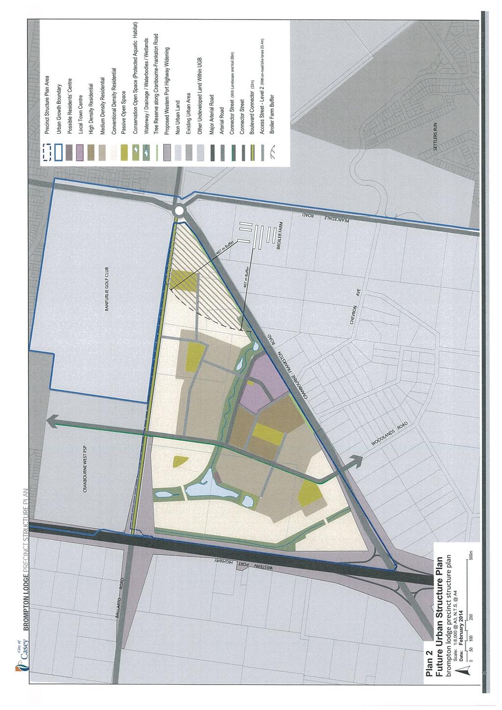
5 1. INTRODUCTION Traffix Group has been engaged by Watsons Pty Ltd on behalf of Wolfdene Pty Ltd to provide traffic engineering assistance for the development of a Precinct Structure Plan (PSP) for the Brompton Lodge site at 1050 Western Port Highway in Cranbourne. This report includes a detailed assessment of traffic generation and distribution for three critical stages of the proposed development at Brompton Lodge and a discussion of the proposed access arrangements and internal road network. 2. BACKGROUND 2.1. LOGICAL INCLUSIONS In 2009, the Logical Inclusions Advisory Committee was established to review land to be incorporated into the State Government s Urban Growth Boundary (UGB). The purpose of the UGB is to set a clear boundary for the outward development of metropolitan Melbourne. With the support of the Metropolitan Planning Authority (MPA) and City of Casey, the Brompton Lodge site 1 a triangular block of land bounded by Western Port Highway, Cranbourne-Frankston Road and Ballarto Road reservation was formally included into the UGB for future development as part of the review process PSP PROCESS The inclusion of Brompton Lodge into the UGB enabled the land to be developed through a Precinct Structure Plan (PSP). The PSP is a structured process to develop the road network, housing, employment and services for future communities in the area. As part of the PSP process for Brompton Lodge, Traffix Group has been engaged to provide detailed assessments of traffic impacts onto the surrounding external road network following development of the site WESTERN PORT HIGHWAY PROJECT VicRoads are in the process of planning the upgrade of the Western Port Highway to a freeway standard. The preferred alignment has been developed after consultation with community stakeholders and land is in the process of being reserved in the Planning Scheme for the upgrade. The preferred alignment includes an overpass of Western Port Highway at Ballarto Road with no direct connection between the two roads and a full diamond interchange at Cranbourne-Frankston Road. The Western Port Highway upgrade allows for Ballarto Road to be extended to the east to connect to Cranbourne-Frankston Road. As part of the Western Port Highway upgrade, VicRoads had undertaken modelling to predict future traffic volumes on a number of arterial roads and major local roads in the vicinity of the Brompton Lodge site including Western Port Highway, Cranbourne-Frankston Road, Ballarto Road and Pearcedale Road. 1 Known as Casey Area 1 in the Logical Inclusions Advisory Committee Report No. 2: South East Growth Area published on 11 November 2011 GRP F Page 1
6 2.4. TRAFFIC VOLUMES Modelling for future traffic volumes in the surrounding road network has been sourced from the Melbourne Planning Authority (MPA) as follows: Future volumes for 2046 based on the South East Growth Corridor Traffic Model (SEGCTM). In addition, the following existing traffic data has also been obtained: Traffic volumes from City of Casey of 12 hour turning movement counts between 7am-7pm at the Ballarto Road/Western Port Highway intersection undertaken on 1 April Through traffic volumes from VicRoads on Western Port Highway, Cranbourne-Frankston Road, Ballarto Road, Pearcedale Road and Woodlands Road for For the purposes of this assessment, the following annual growth rates had been applied to the abovementioned existing traffic data to estimate existing volumes for 2014 (used for assessing the 2014 interim stage): Western Port Highway 5% Cranbourne-Frankston Road west of Western Port Highway 4% Cranbourne-Frankston Road between Western Port Highway & Pearcedale Road 3% Cranbourne-Frankston Road east of Pearcedale Road 4% Ballarto Road west of Western Port Highway 2% Pearcedale Road south of Cranbourne-Frankston Road 5% 3. EXISTING CONDITIONS The Brompton Lodge site is triangular in shape (encompassing an area approximately 103.5ha) and is bounded by Cranbourne-Frankston Road to the southeast, Western Port Highway to the west, and the unused Ballarto Road reservation to the north. A locality map of the site is shown at Figure 1. The site is located entirely within an Urban Growth Zone as shown in the Casey Planning Scheme at Figure 2. Planning zones in the site s greater surroundings include Urban Growth Zone to the north, Residential Zone to the west and east, and Green Wedge Zone to the south. Significant land uses within the vicinity of the site include a number of golf courses to the north and east, and the Royal Botanic Gardens Cranbourne to the east which also has an access onto Ballarto Road. GRP F Page 2


7 Brompton Lodge Site Figure 1: Locality Map Reproduced with permission from Melway Publishing Pty Ltd Brompton Lodge Site Figure 2: Planning Zone Map Source: Planning Maps Online, DPCD GRP F Page 3
8 3.1. ROAD NETWORK Western Port Highway (also known as Dandenong-Hastings Road) is an arterial road under the jurisdiction of VicRoads that spans in a north-south direction between the South Gippsland Highway and Frankston-Flinders Road. Within the vicinity of the subject site it consists of a four lane carriageway separated by a central median. Cranbourne-Frankston Road is an arterial road under the jurisdiction of VicRoads that spans in an east-west direction between Monahans Road to McMahons Road. Within the vicinity of the subject site it consists of a four lane carriageway separated by a central median. Ballarto Road is an arterial road under the jurisdiction of VicRoads that spans in an east-west direction between Western Port Highway and Dandenong-Frankston Road. An unsealed section of Ballarto Road continues eastward from Cranbourne-Frankston Road to the Royal Botanic Gardens Cranbourne, with a gap between Western Port Highway and Cranbourne-Frankston Road separating the two sections. The section to the west of Western Port Highway consists of a single carriageway (with one lane in each direction). Pearcedale Road is a major Council road that spans in a north-south direction between Cranbourne- Frankston Road and Baxter-Tooradin Road. Within the vicinity of the subject site it consists of a two lane carriageway. Woodlands Road is a local Council road that spans in a north-south direction between Cranbourne- Frankston Road to a dead end approximately 150m east of Stanhill Drive. Within the vicinity of the subject site it consists of a single carriageway accommodating traffic in both directions. Chevron Avenue is a local Council road that spans in an east-west direction between Pearcedale Road and Cranbourne-Frankston Road. Within the vicinity of the subject site it consists of a single carriageway accommodating traffic in both directions. GRP F Page 4
9 4. PROPOSAL A PSP is being developed for the Brompton Lodge site to facilitate residential development and a Neighbourhood Activity Centre (NAC). The PSP takes into account the proposed upgrade of the Western Port Highway including the grade separation and removal of the existing intersection at Ballarto Road, and the eastern extension of Ballarto Road to connect to Cranbourne-Frankston Road. The ultimate yield for the Precinct Structure Plan is in the order of 1,500 lots and a Neighbourhood Activity Centre (NAC) with an area of 8,300m 2. Development plans provided by Wolfdene are attached at Appendix A VEHICLE ACCESSIBILITY The proposed access arrangements for the site includes two signalised access points (termed in this report as Western Signals and Eastern Signals ) to Cranbourne-Frankston Road on the southern boundary of the site, and two unsignalised access points to the future Ballarto Road extension on the northern boundary of the site (termed in this report as Western Ballarto Access and Eastern Ballarto Access ). It is understood that Council intend to construct the missing section of Ballarto Road between Western Port Highway and Cranbourne-Frankston Road as an ultimate dual carriageway road, and that the southern carriageway is to be constructed as part of the Brompton Lodge development. Residential lots that form part of the development site are proposed to have direct frontage to this road. The Western Signals access to Cranbourne-Frankston Road comprises of a cross intersection with Woodlands Road approximately 600m east of Western Port Highway. The Eastern Signals access comprises of a T-intersection and is located approximately 670m east of Woodlands Street and 800m west of the existing roundabout at Pearcedale Road. The proposed NAC is to be located adjacent to the Eastern Signals. The Western Ballarto Access is proposed to ultimately form a cross intersection linking into the northsouth connector road of the future Cranbourne West development area to the north. This intersection would ultimately be signalised in the event that Ballarto Road ultimately becomes a four lane arterial road. The Eastern Ballarto Access is proposed to remain an unsignalised T-intersection STAGING AND ACCESS The PSP is proposed to be delivered in 20 stages commencing at the northwest corner of the site with each stage comprising the development of between 30 to 120 residential lots. For the initial stages the upgrade of Western Port Highway is unlikely to have commenced and it is proposed to construct a temporary access to form the east leg of the existing Western Port Highway/Ballarto Road roundabout. For traffic safety reasons, it is understood that the Metropolitan Planning Authority (MPA) considers a 300 dwelling limit to be appropriate for estates that only use one vehicle access point connecting to the external road network. Only one vehicle access point to the external road network is proposed for the initial stages of the Brompton Lodge development. For the purposes of this assessment we have considered the initial stages to accommodate 270 dwellings (representing full development of the first five stages), which falls within the 300 dwelling limit advocated by the MPA. Following completion of these initial stages, it is proposed to construct the Western Signals to the site from Cranbourne-Frankston Road forming a signalised cross intersection at Woodlands Avenue. These two access points will work in tandem until the Eastern Signals are constructed or until the Western Port Highway upgrade occurs when the Ballarto Road connection to Western Port Highway is removed. The construction of the full length of Ballarto Road would coincide with the final stage of development and as lots are developed fronting this road. GRP F Page 5
10 5. TRAFFIC IMPACT 5.1. TRAFFIC GENERATION AND DISTRIBUTION The following section details the traffic generation and traffic distribution methodology and assumptions adopted for the intersection capacity analysis presented in Section Traffic Generation Residential A conservative assumption for the total number of daily vehicle movements per residential lot for outer metropolitan residential developments is 10 vehicle movements per lot. Following completion of the NAC, it is anticipated that 15% of these trips will be internal trips as the destination for these trips will be to services that are already provided for within the NAC. Traffic generated from the residential lots at each of the three scenarios is shown at Table 1. Table 1: Residential Generated Traffic Daily Volume Peak Hour Volume Scenario Total Internal External Interim 2, ,700 Intermediate 10, ,700 Ultimate 15,000 2,250 12,750 Interim Intermediate 1, ,070 Ultimate 1, ,275 Neighbourhood Activity Centre (NAC) For the purposes of predicting traffic generation associated with the NAC, the RTA Guide to Traffic Generating Developments (the RTA Guide) has been relied upon. The RTA Guide was developed by the Roads and Traffic Authority of NSW and can be used as a guideline for estimating traffic generation for retail developments such as those commonly found in a NAC. In particular, Table 3.1 of Section 3 Land Use Traffic Generation of the RTA Guide specifies peak hour and daily traffic generation rates of 12.5 and 121 vehicle trips per 100m 2 of gross leasable floor area (GLFA) for a Friday and Thursday respectively. We consider this to be appropriate rates to use for the NAC (conservatively assuming that its 8,300m 2 area is GLFA). The external trips generated by the NAC can be calculated (as shown in Table 2) by subtracting the internal trips generated by the residential development within the development. Table 2: NAC Generated Traffic Total Internal External Daily Volume 10,043 2,250 7,793 Peak Hour Volume 1, Based on our experience, a proportion of visitors to activity centres are drivers who are already on the road network as part of another trip. For the purposes of this assessment, this proportion is taken as 50% (i.e. 50% of external visitors to the NAC have made a trip for the exclusive purpose of visiting the NAC and not as an intermediate destination as part of a trip somewhere else). This assumption was used for the ultimate scenario assessment presented later in the report. GRP F Page 6
11 Traffic Distribution An assessment of the likely distribution of traffic generated from the site has been made having regard to the external road network and areas of activity in the greater vicinity of the site s surroundings. Based on our assessments, it is our opinion that traffic from the site will most likely be heading to and from the north due to the greater number of employment areas, services and facilities, as well as the Monash Freeway which would carry the majority of city bound traffic. The activity centres of Frankston (west of the site) and Cranbourne (east of the site) were considered to be the next two most likely destination points, while traffic heading south towards Hastings was assumed to represent the smallest distribution of the total site traffic generation. Traffic distributions adopted for the assessment are shown at Table 3. Table 3: Site Traffic Distribution Percentages Origin/Destination North South East West Percentage 60% 5% 15% 20% Tables showing how traffic from the development is expected to be distributed to the external road network based on the traffic distribution percentages shown at Table 3 at the three critical stages of the development are attached in Appendix B Peak Hour Splits From our experience, peak hour vehicle trips going to and from the site for AM and PM periods generally adopted for outer metropolitan residential land uses are as follows: AM peak period 20% arrivals, 80% departures PM peak period 60% arrivals, 40% departures AM and PM peak hour splits for the NAC have been adopted as follows: AM peak period 90% arrivals, 10% departures PM peak period 50% arrivals, 50% departures The peak hour volumes were assumed to be 10% of the daily trips for all assessments INTERSECTION CAPACITY ANALYSIS An assessment of traffic impact from the development has been undertaken at three critical stages as follows: Interim scenario allowing for approximately 270 lots with the only access via the Western Port Highway/Ballarto Road roundabout. Intermediate scenario when 1,070 lots are developed with access available from the Western Signals and assuming that the Ballarto Road overpass has been constructed. Ultimate scenario when all 1,500 lots and the NAC are developed with access via two signalised access points to Cranbourne-Frankston Road and three access points to the future Ballarto Road extension. SIDRA assessments have been undertaken for the site s signalised access points and arterial road intersections in each scenario. The operating conditions described in the SIDRA User Guide, shown in Table 4 below, have been used to assess the intersection performances. Summaries of the SIDRA outputs are attached at Appendix C. GRP F Page 7
12 Table 4: SIDRA Intersection Operating Performance Ratings Rating Degree of Saturation (DOS) Level of Service (LOS) Excellent DOS < 0.6 LOS A Very Good 0.6 < DOS < 0.7 LOS B Good 0.7 < DOS < 0.8 LOS C Fair 0.8 < DOS < 0.9 LOS D Poor 0.9 < DOS < 1.0 LOS E Very Poor DOS > 1.0 LOS F 5.3. INTERIM SCENARIO For the purposes of our assessment full development of up to 270 lots has been assumed for the interim scenario. The only access point to the external road network is located at the north of the site which will connect to a new eastward extension of Ballarto Road from the Ballarto Road/Western Port Highway intersection. Only the Ballarto Road/Western Port Highway intersection has been assessed in detail given it will be the only access point for vehicles driving to and from the Brompton Lodge site in the interim scenario Site Traffic Generation and Distribution By adopting the traffic generation and distribution assumptions from Section 5.1, the anticipated site generated volumes and distribution is shown in Table 5. Table 5: Interim Scenario Site Traffic Distribution Origin/Destination North South West East Percentage 60% 5% 20% 15% Daily Trips 4, ,660 1,245 Peak Hour Trips It was assumed that all eastbound traffic will turn left onto Cranbourne-Frankston Road at the north approach of the Western Port Highway/Cranbourne-Frankston Road intersection in order to head east. As such, all eastbound traffic was counted as having a south distribution at the Ballarto Road/Western Port Highway intersection. Figure 3 shows the distribution of arrival and departure vehicle trips at the Ballarto Road/Western Port Highway intersection during the peak hour periods by adopting the peak hour splits from Section GRP F Page 8
13 N 54 (162) Peak Hour AM (PM) Ballarto Rd 130 (65) 11 (32) 43 (22) 11 (5) 11 (32) SITE Western Port Hwy Figure 3: Interim Scenario Site Generated Volumes and Distribution Arterial Road Volumes and Distribution Data of traffic volumes from 2011 on the arterial roads adjacent to the Brompton Lodge site have been obtained from VicRoads and calibrated to the year 2014 using the annual growth rates outlined in Section 2.4. This includes annual growth rates of 5% for Western Port Highway and 2% for Ballarto Road west of Western Port Highway. The distribution of external traffic at the Ballarto Road/Western Port Highway intersection have been based on distributions calculated from a 12 hour intersection turning movement count (7am-7pm) undertaken by VicRoads in April Based on the above, Figure 4 below depicts the distribution of calibrated 2014 volumes for the AM and PM peak hours at the intersection. N 281 (296) 841 (1477) Peak Hour AM (PM) Ballarto Rd 301 (317) 11 (32) 73 (222) 160 (64) 1515 (895) SITE Western Port Hwy Figure 4: Ballarto Rd/Western Port Hwy Calibrated 2014 Volumes and Distributions Figure 5 below presents the overall predicted traffic volumes and distributions during the peak hours at Ballarto Road/Western Port Highway following development of the first 270 lots. GRP F Page 9

14 N 281 (296) 841 (1477) 54 (162) Peak Hour AM (PM) Ballarto Rd 301 (317) 130 (65) 11 (32) 43 (22) 73 (222) 11 (5) 160 (64) 1515 (895) 11 (32) SITE Western Port Hwy Figure 5: Ballarto Rd/Western Port Hwy Post-Development Volumes and Distributions SIDRA Intersection Assessment SIDRA analysis has been undertaken for the interim scenario future traffic volumes and distributions at Ballarto Road/Western Port Highway as presented in Figure 5. Figure 6 shows the intersection layout adopted for the analysis and Table 6 presents the key intersection performance indicators in the AM and PM peak hours. Figure 6: SIDRA Intersection Layout Ballarto Rd/Western Port Hwy Interim Scenario The intersection layout shows it is proposed to construct two approach lanes and a single departure lane on the eastern leg, with the approach lanes consisting of a shared through/right lane and an exclusive left turn lane. GRP F Page 10
15 Table 6: Key Intersection Parameters Ballarto Rd/Western Port Hwy Interim Scenario AM Peak Approach Degree of Saturation Average Delay (sec) 95 th Percentile Queue Length (m) Level of Service Western Port Hwy (south) LOS B Ballarto Rd (east) LOS B Western Port Hwy (north) LOS B PM Peak Ballarto Rd (west) LOS C Approach Degree of Saturation Average Delay (sec) 95 th Percentile Queue Length (m) Level of Service Western Port Hwy (south) LOS B Ballarto Rd (east) LOS B Western Port Hwy (north) LOS B Ballarto Rd (west) LOS B The SIDRA analysis indicates that the addition of an eastern leg to the existing Ballarto Road/Western Port Highway as part of the development of the first 270 lots will operate satisfactorily. The southern approach through movement will be the most critical movement in the AM peak hour and the northern approach through movement will be the most critical movement in the PM peak hour. The most critical Degree of Saturation of is within the SIDRA fair performance rating. A plan of the functional layout of the Ballarto Road access via the roundabout at Western Port Highway for the interim scenario is attached at Appendix D INTERMEDIATE SCENARIO The intermediate scenario assumes full development for Stages 1 to 15 with a total yield in the order of 1,070 dwellings. Following the grade separation of the Western Port Highway/Ballarto Road intersection it is anticipated that most traffic from the development will use the Western Signals at Cranbourne-Frankston Road, although a small amount of traffic may continue to use Ballarto Road to head west towards Frankston and Seaford. The critical intersection assessed in this stage is the Western Signals at Cranbourne-Frankston Road where most of the traffic will access the site Site Traffic Generation and Distribution Adopting the traffic generation and distribution assumptions from Section 5.1, the anticipated site generated volumes and distribution is shown in Table 7. Table 7: Intermediate Scenario Site Traffic Distribution Origin/Destination North South West East Percentage 60% 5% 20% 15% Daily Trips 6, ,140 1,605 Peak Hour Trips To determine the volume of site traffic using the Western Signals or Ballarto Road overpass at Western Port Highway, an assessment into the likely route of traffic from each of the stages heading to/from the north, south, west and east has been made. Full results of this analysis can be found in Appendix B. GRP F Page 11
16 Figure 7 shows the distribution of site arrival and departure vehicle trips at the Western Signals and Ballarto Road overpass at Western Port Highway during the AM and PM peak hour periods by adopting the peak hour splits from Section N Peak Hour AM (PM) Figure 7: Intermediate Scenario Site Generated Volumes and Distribution Arterial Road Volumes and Distribution To determine the traffic volumes on the arterial roads in the intermediate scenario, an interpolation between the predicted 2046 volumes (based on the South East Growth Corridor Traffic Model) and the 2014 volumes (documented previously) was undertaken. The volumes for the intermediate scenario have been interpolated to represent the year 2024, which would reflect the first ten years of coinciding with the intermediate scenario. The interpolation accounts for consistent yearly external growth rates along the existing arterial road network and assumes that Ballarto Road between Western Port Highway and Cranbourne-Frankston Road has not been constructed. For the purposes of the analysis, annual growth rates outlined in Section 2.4 had been adopted. Woodlands Road volumes were obtained from City of Casey. A seven day count had been undertaken in February 2012 with the peak hour volumes taken over a weekday average and it is assumed that there will be no change to this traffic in Distributions of residential from Woodlands Road were assumed to be the same as those applied to the Brompton Lodge site. Traffic heading between Woodlands Road and Brompton Lodge was considered negligible in the intermediate scenario. An estimate of the likely distribution of the external traffic at the Western Port Highway/Cranbourne Frankston Road and Cranbourne-Frankston Road/Pearcedale Road intersections has been made for the year 2024 to reflect the intermediate scenario. Figure 8 below depicts the estimated peak hour vehicle turning movements at the Western Signals in the year 2024 for the intermediate scenario excluding development traffic. GRP F Page 12
17 N Peak Hour AM (PM) Cranbourne Frankston Rd 1006 (1333) 1274 (1288) 3 (10) 0 (2) 10 (6) 2 (1) SITE Woodlands Rd Figure 8: Western Signals Predicted External Volumes and Distributions Figure 9 below presents the overall predicted traffic volumes and distributions during the peak hours at the Western Signals combining the development and external traffic at the intermediate scenario. N Cranbourne Frankston Rd 675 (337) 0 (0) 128 (64) Peak Hour AM (PM) 169 (506) 32 (96) 1006 (1333) 1274 (1288) 3 (10) 0 (2) 10 (6) 0 (0) 2 (1) SITE Woodlands Rd Figure 9: Intermediate Scenario Western Signals Post-Development Volumes and Distributions GRP F Page 13

18 SIDRA Intersection Assessment SIDRA analysis has been undertaken for the intermediate scenario future traffic volumes and distributions at the Western Signals intersection presented in Figure 9. Figure 10 shows the intersection layout adopted for the analysis and Table 8 presents the key intersection performance indicators in the AM and PM peak hours for the intermediate scenario. Figure 10: SIDRA Intersection Layout Western Signals Intermediate Scenario The proposed layout incorporates auxiliary right and left turn lanes on the Cranbourne-Frankston Road approaches with left turn slip lanes provided to and from the site access. The site access is proposed to incorporate two right turn lanes including a shared through/right lane and an exclusive right turn lane. It is proposed to operate the site with split phasing for the site access and Woodlands Road given the significant imbalance in traffic volumes. Table 8: Key Intersection Parameters Western Signals Intermediate Scenario AM Peak Approach Degree of Saturation Average Delay (sec) 95 th Percentile Queue Length (m) Level of Service Woodlands Rd (SE) LOS E Cranbourne-Frankston Rd (NE) LOS C Brompton Lodge Access (NW) LOS D Cranbourne-Frankston Rd (SW) LOS C PM Peak Approach Degree of Saturation Average Delay (sec) 95 th Percentile Queue Length (m) Level of Service Woodlands Rd (SE) LOS E Cranbourne-Frankston Rd (NE) LOS C Brompton Lodge Access (NW) LOS E Cranbourne-Frankston Rd (SW) LOS B GRP F Page 14
19 The SIDRA analysis indicates that the development of the Western Signals as part of the development of the first 1,070 lots will operate satisfactorily. The right turn out of the Brompton Lodge site is the most critical movement in the AM peak hour, and the through movement at the southwest approach on Cranbourne-Frankston Road is the most critical movement in the PM peak hour. The critical Degree of Saturation is which is within the SIDRA fair performance rating. Functional layout plans for the Western Signals intersection have been based on the existing four lane cross-section of Cranbourne-Frankston Road and are attached at Appendix E. This appendix also includes functional layout plans for the activity centre access and Eastern Signals intersection on Cranbourne-Frankston Road based on the existing four lane cross-section of Cranbourne-Frankston Road. It is noted that the plans include bus priority lanes as required by Council ULTIMATE SCENARIO The ultimate scenario assumes full development of Brompton Lodge with a total yield in the order of 1,500 dwellings and an 8,300m 2 NAC. The site will be accessed via two signalised access points ( Western Signals and Eastern Signals ) connecting to Cranbourne-Frankston Road, and three unsignalised access points connecting to Ballarto Road ( Western Ballarto Access, Centre Ballarto Access and Eastern Ballarto Access ). The ultimate scenario assumes that Ballarto Road has been extended between Western Port Highway and Pearcedale Road. The two signalised access points are considered to be most critical due to the higher traffic volumes and have been analysed in detail Site Traffic Generation and Distribution Adopting the traffic generation and distribution assumptions from Section 5.1, the anticipated site generated volumes and distributions for the residential component and the NAC are shown in Table 9. Table 9: Ultimate Scenario Site Traffic Distribution Origin/Destination Percentage Daily Trips Residential Peak Hour Trips Daily Trips NAC Peak Hour Trips North 60% 7, , South 5% West 20% 2, , East 15% 1, , To determine the volume of site traffic utilising either the Western Signals or Eastern Signals, an assessment into the likely route of traffic from each of the stages heading to/from the north, south, west and east has been made. It should be noted that it was assumed all external traffic accessing the NAC would utilise the Eastern Signals. Full results of this analysis can be found in Appendix B. Figure 11 shows the distribution of arrival and departure vehicle trips at the Western Signals and Eastern Signals during the AM and PM peak hour periods by adopting the splits from Section 5.1. GRP F Page 15
20 N Peak Hour AM (PM) 2 (6) Figure 11: Ultimate Scenario Site Generated Volumes and Distribution Arterial Road Volumes and Distribution Data for 2046 arterial road volumes has been obtained from the South East Growth Corridor Traffic Model (SEGCTM). The SEGCTM used for this analysis is based on the Victorian Integrated Transport Model (VITM). It is noted that the SEGCTM does not include any traffic generated from development of the Brompton Lodge site. Volumes in the model have also been expressed as PCU (Passenger Car Unit) volumes in which heavy vehicle volumes are converted into standard car volumes by a multiplication factor. It is understood that the VITM uses factors of 1.3 and 2.3 for rigid trucks and articulated trucks. The SEGCTM 2046 arterial road volumes are provided for both the AM and PM peak hours. Figure 12 depicts the predicted arterial road volumes on the adjacent road network used in the ultimate scenario assessment. It is noted that although not shown in Figure 12, the same volumes and distributions of Woodlands Road traffic from the intermediate scenario have been included for the ultimate scenario assessments. Figure 13 presents the overall predicted traffic volumes and some of the distributions during the peak hours at the Western Signals, Eastern Signals and Cranbourne-Frankston Road/Pearcedale Road/Ballarto Road intersection following full development of the Brompton Lodge site incorporating site generated and external traffic volumes. Note that in this diagram some of the external through traffic on Cranbourne-Frankston Road is directed into the proposed NAC (50% of the externally generated traffic by the NAC is assumed to be traffic already on the road network). GRP F Page 16
21 N Peak Hour AM (PM) Figure 12: SEGCTM 2046 Predicted Arterial Traffic Volumes N Peak Hour AM (PM) Figure 13: Ultimate Scenario Post-Development Traffic Volumes GRP F Page 17
22 SIDRA Intersection Assessment SIDRA analysis has been undertaken for the ultimate scenario future traffic volumes and distributions for the Western Signals and Eastern Signals. Figure 14 and Figure 15 show the intersection layouts adopted for the analysis and Table 10 and Table 11 present the key intersection performance indicators in the AM and PM peak hours for the ultimate scenario. It is noted that for the purposes of the SIDRA analysis, heavy vehicle volumes have been considered as a percentage of the total traffic volume, which is consistent with the previous SIDRA analysis for other scenarios. However, this would result in conservative volumes for heavy vehicles on the arterial roads due to the SEGCTM model expressing total traffic volumes as PCU (Passenger Car Unit), in which heavy vehicle volumes have already been factored in the total traffic volumes as a multiplication of a standard car unit. Western Signals Figure 14: SIDRA Intersection Layout Western Signals Ultimate Scenario It is understood that VicRoads has ultimately proposed that Cranbourne-Frankston Road will accommodate three through traffic lanes in both directions. Accordingly, this ultimate cross-section has been assumed for the SIDRA analysis for the ultimate scenario. GRP F Page 18
 0.835 25.9 314.8 LOS C Brompton Lodge Access (NW) 0.822 60.2 100.1 LOS E Cranbourne-Frankston Rd (SW) 0.748 21.3 250.")
23 Table 10: Key Intersection Parameters Western Signals Ultimate Scenario AM Peak Approach Degree of Saturation Average Delay (sec) 95 th Percentile Queue Length (m) Level of Service Woodlands Rd (SE) LOS E Cranbourne-Frankston Rd (NE) LOS C Brompton Lodge Access (NW) LOS E Cranbourne-Frankston Rd (SW) LOS C PM Peak Approach Degree of Saturation Average Delay (sec) 95 th Percentile Queue Length (m) Level of Service Woodlands Rd (SE) LOS E Cranbourne-Frankston Rd (NE) LOS C Brompton Lodge Access (NW) LOS D Cranbourne-Frankston Rd (SW) LOS B The through movement at the northeast approach on Cranbourne-Frankston Road (heading southwest) was found to be the critical movement in the AM peak hour. The through movement and right movement at the northwest approach on the Brompton Lodge Access was found to be the next most critical movement, also in the AM peak hour. The results suggested that the AM peak hour was found to be more critical than the PM peak hour. The critical Degree of Saturations of (northeast approach on Cranbourne-Frankston Road) and (northwest approach on Brompton Lodge Access) is within the SIDRA fair performance rating. Eastern Signals Figure 15: SIDRA Intersection Layout Eastern Signals Ultimate Scenario GRP F Page 19
24 The proposed layout provides for an auxiliary right turn lane at the northeast approach on Cranbourne- Frankston Road. Three through lanes are proposed on the northeast and southwest approaches on Cranbourne-Frankston Road to match the ultimate cross-section for Cranbourne-Frankston Road proposed by VicRoads. For the site access, left turn slip lanes are provided to and from the site, and it is proposed to include two exclusive right turn lanes at the site access approach. Table 11: Key Intersection Parameters Eastern Signals Ultimate Scenario AM Peak Approach Degree of Saturation Average Delay (sec) 95 th Percentile Queue Length (m) Level of Service Cranbourne-Frankston Rd (NE) LOS B Brompton Lodge Access (NW) LOS D Cranbourne-Frankston Rd (SW) LOS B PM Peak Approach Degree of Saturation Average Delay (sec) 95 th Percentile Queue Length (m) Level of Service Cranbourne-Frankston Rd (NE) LOS B Brompton Lodge Access (NW) LOS D Cranbourne-Frankston Rd (SW) LOS B Overall, the through movement at the southwest approach on Cranbourne-Frankston Road (heading northeast) was found to be the critical movement in both the AM peak hour and PM peak hour. The critical Degree of Saturation of is within the SIDRA excellent performance rating. Functional layout plans for the ultimate Cranbourne-Frankston Road intersections, including the left in/left out access to the activity centre based on the ultimate six lane cross section are attached at Appendix F. For these plans the existing on-road bicycle lanes are replaced with 3m wide shared paths. Cranbourne-Frankston Road / Ballarto Road / Pearcedale Road It is understood that at present the anticipated layout and type of intersection (i.e. roundabout, signals, etc.) at Cranbourne-Frankston Road / Ballarto Road / Pearcedale Road has not yet been determined. As such, no SIDRA analysis has been undertaken at this intersection as part of this assessment, given that traffic capacity will be dependent on the layout and type of intersection PROPOSED INTERSECTION LOCATIONS Cranbourne-Frankston Road The proposed access arrangement involves the installation of two signalised intersections to provide access into the site from Cranbourne-Frankston Road over a length of 2,070m. This is generally in accordance with VicRoads internal Access Management Policies which suggests that signalised intersections should be 800m apart on limited access urban arterial roads such as Cranbourne- Frankston Road. We note that due to the volume of traffic that is expected to access the site from Cranbourne- Frankston Road it would not be appropriate to provide only a single signalised access point over this length as this would be likely to result in greater delays and queuing along Cranbourne-Frankston Road due to the amount of opposing traffic that would require longer signal phases to operate for opposing movements. During the intermediate condition the location of the Western Signals to the existing Western Port Highway/Cranbourne-Frankston Road roundabout will be approximately 600m. In the ultimate condition the Western Port Highway/Cranbourne-Frankston Road intersection will be grade separated and the spacing between the Western Signals and the future intersection at the Western Port Highway freeway ramps will be reduced to approximately 470m. Also in the ultimate condition, the GRP F Page 20
25 location of the Eastern Signals to the future five legged roundabout at Pearcedale Road/Cranbourne- Frankston Road is approximately 800m. The distance between the Eastern Signals and Western Signals will be approximately 700m in both the intermediate and ultimate conditions. We consider that the distances between the signalised intersections and other major intersections in the intermediate and ultimate conditions to be appropriate in providing for an acceptable operation between the site s access points and the surrounding road network. The proposed location of the two signalised intersections are sufficient to contain right turn lanes from adjacent intersections without requiring them to overlap, and SIDRA analysis suggests that the intersection spacing is sufficient that queues from one intersection will not extend through another. In addition to the two signalised access points it is also proposed to provide a separate left in/left out access to the NAC from Cranbourne-Frankston Road. This access is proposed to be provided approximately 180m to the west of the Eastern Signals. This separate access point to the NAC is considered appropriate and will relieve pressure on the Eastern Signals. The proposed spacing is sufficient that traffic exiting the site at this location should generally not be impacted by traffic queues from the Eastern Signals Ballarto Road In the ultimate stage there will be two permanent access points proposed to the Ballarto Road extension: the Western Ballarto Access and Eastern Ballarto Access located approximately 500m and 1km east of the Western Port Highway respectively. The Western Ballarto Access will form a cross intersection that would continue as a north-south connector road into the Cranbourne West development area to the north. It would be appropriate for this intersection to be controlled by a single lane roundabout in the event that the Ballarto Road extension is constructed as a connector road or by traffic signals in the event that Ballarto Road is ultimately upgraded to a four lane arterial road. It is understood that the Ballarto Road extension will ultimately be constructed as a boulevard connector road with a 32m reservation or a four lane arterial within a 34m reservation, however a decision is yet to be made by VicRoads and Council (see Section 5.8.2). The remaining access point to Ballarto Road should operate sufficiently as an unsignalised intersection, with auxiliary left and right turn lanes provided in Ballarto Road to provide access into the site without delaying through traffic. It is proposed that the temporary access (located approximately 250m east of the existing roundabout at Western Port Highway) serving the Brompton Lodge site in the interim stage would be removed at the time when the Ballarto Road overpass over the Western Port Highway is constructed SIGHT DISTANCE This section provides an assessment of sight distance at the Brompton Lodge access points closest to Western Port Highway (i.e. Western Signals and Western Ballarto Access ). The purpose of the assessment is to investigate whether sight distance may be restricted due to the proposed vertical alignment of Cranbourne-Frankston Road and Ballarto Road due to the future provision of overpasses at the Western Port Highway (i.e. in the ultimate stage). Longitudinal section plans were obtained from VicRoads for both Cranbourne-Frankston Road and Ballarto Road to undertake the assessment. These plans are shown at Figure 16 and Figure 17 and also include the approximate locations of the proposed access points. The plans extend approximately 180m to 200m to the east beyond the proposed access point locations. GRP F Page 21
26 Western Port Highway Western Signals Figure 16: Cranbourne-Frankston Road Longitudinal Section Figure 16 shows that the Western Port Highway is located at the peak of a 408m long summit curve. Heading east there is an 82m downgrade at 4% followed by a 281m sag curve and a 220m summit curve. The location of the Western Signals is located approximately 50m along the 220m summit curve to the east of the highway. Western Port Highway Western Ballarto Access Figure 17: Ballarto Road Longitudinal Section Figure 17 shows that the Western Port Highway is located at the peak of a 312m long summit curve. Heading east there is a 41m downgrade at 4% followed by a 150m sag curve and then a 180m upgrade at 2%. The location of the Western Ballarto Access is approximately at the end of the 2% upgrade and the beginning of a 92m long summit curve. The assessment was undertaken by measuring the approximate sight distance to either side of the access points (assuming a driver eye height of 1.1m and object height of 1.25m). The Austroads Guide to Road Design Part 4A: Unsignalised and Signalised Intersections (the Austroads Guide ) was used to calculate the required Safe Intersection Sight Distance (SISD). The sight distance is deemed adequate if it is greater than the required SISD. A summary of the sight distance assessment is described as follows: GRP F Page 22
27 Western Signals (Cranbourne-Frankston Road) Based on an 80km/h speed limit on Cranbourne-Frankston Road, standard values for other Austroads Guide parameters and grade correction factors provided in the Austroads Guide, the SISD was calculated to be 175m to the west and 188m to the east. The available sight distance based on the longitudinal section plan shown at Figure 16 is estimated to be in excess of 400m to the west and approximately 200m to the east which is close to the edge of the longitudinal section that has been provided. Western Ballarto Access Based on an 80km/h speed limit on Ballarto Road, standard values for other Austroads Guide parameters and grade correction factors provided in the Austroads Guide, the SISD was calculated to be 177m to the west and 185m to the east. The available sight distance based on the longitudinal section plan shown at Figure 17 was estimated to be in excess of 400m to the west and approximately 200m to the east which is close to the edge of the longitudinal section that has been provided. We are satisfied that based on an assessment of longitudinal section plans of Cranbourne-Frankston Road and Ballarto Road, the provision of sight distance will be adequate at both the Western Signals and Western Ballarto Access in the ultimate stage ROAD CROSS SECTIONS Internal Roads The internal road network, proposed intersection controls, and carriageway widths are considered to be generally provided in accordance with the specifications outlined by the Metropolitan Planning Authority and provide for a practical outcome Ballarto Road It is understood that Council has nominated the ultimate cross section of the Ballarto Road extension to be either a two lane boulevard connector within a 32m cross section, or a four lane arterial within a 34m cross section, however a decision is yet to be made in conjunction with VicRoads. The 32m boulevard connector cross section option would consist of two 5.8m wide carriageways separated by a 6.4m wide median. Each carriageway would consist of a single 3.5m traffic lane and a 2.3m wide parking lane, with a verge width of 7m incorporating a 3m wide shared path. A diagram of this cross section is shown at Figure 18. The 34m four lane arterial cross section option would consist of two 7.7m wide carriageways separated by a 6.0m wide median. Each carriageway would consist of two traffic lanes, one 3.5m wide and the other 4.2m wide. A 5.5m wide clear zone would be maintained from the kerb to the shared path. Bus stops can be accommodated within this clear zone. A diagram of the cross section is shown at Figure 19. In order to implement either cross section it will be necessary to widen the existing reservation for Ballarto Road of approximately 29m by a minimum of approximately 3m to the south. It is considered that the Brompton Lodge development will contribute to the construction of the Ballarto Road extension by constructing a single carriageway along the alignment of the ultimate southern carriageway. This interim carriageway will need to be constructed at a width that is no less than 9.3m wide in order to accommodate two way traffic and a parking lane prior to the construction of the northern carriageway in the event that direct residential abuttal is proposed on the south side. The boulevard connector road option for Ballarto Road would support direct residential abuttal; however this would not be desirable if Ballarto Road would ultimately function as an arterial road. GRP F Page 23

28 Figure 18: Ballarto Road 32m Boulevard Connector Cross Section Figure 19: Ballarto Road 34m Four Lane Arterial Cross Section GRP F Page 24
29 6. CONCLUSION Having undertaken a detailed traffic engineering assessment for the proposed Brompton Lodge Precinct Structure Plan, we are of the opinion that: a) The proposed interim access arrangement involving the construction of an east leg to the existing roundabout at Ballarto Road/Western Port Highway will operate sufficiently in order to provide access for the development of 270 residential lots, b) The proposed construction of a signalised cross intersection where Woodlands Road currently intersects with Cranbourne Frankston Road ( Western Signals ) is appropriate and can accommodate anticipated traffic volumes in the intermediate scenario (1,070 lots for Stages 1 to 15) as the predominant access point to the site following grade separation of the Ballarto Road/Western Port Highway intersection, c) Two signalised access points and an unsignalised left in/left out access to Cranbourne-Frankston Road and one unsignalised access and either a four leg roundabout or signalised cross-intersection on Ballarto Road is appropriate to provide access to the site, depending on whether Ballarto Road will ultimately be developed as a boulevard connector or four lane arterial road, d) The proposed access points will be able to accommodate future traffic generated by the ultimate development of the site incorporating 1,500 lots and an 8,300m 2 Neighbourhood Activity Centre without causing detrimental impacts to the surrounding road network, e) The proposed site access locations and forms of intersection control along Cranbourne-Frankston Road and the future Ballarto Road extension are appropriate, f) The future unsignalised T-intersection along the Ballarto Road extension should incorporate left and right turn auxiliary lanes, g) Sight distance to and from the western access points to the Brompton Lodge site is found to be satisfactory in the ultimate stage following the construction of the Cranbourne-Frankston Road and Ballarto Road overpasses at Western Port Highway, and h) There are no traffic engineering reasons why the development as outlined in the Precinct Structure Plan should not be approved. GRP F Page 25
30 APPENDIX A DEVELOPMENT PLANS GRP F
31
PROPOSED RESIDENTIAL SUBDIVISION
 PROPOSED RESIDENTIAL SUBDIVISION PART OF TARNEIT ROAD & 1121 DOHERTYS ROAD, TARNEIT Prepared For: TCG (RM) Developments Pty Ltd MARCH 2014 OUR REF: 16740R#1 PROPOSED RESIDENTIAL SUBDIVISION PART OF TARNEIT
Traffic and Transport Assessment
 Traffic and Transport Assessment Section 96 Residential Subdivision, Davis Road Tarneit CG120370 Prepared for Stockland Pty Ltd 19 February 2013 Document Information Prepared for Stockland Pty Ltd Project
Traffic Engineering Assessment. Additional Traffic Modelling at Minta Farm PSP 11. Prepared for Victorian Planning Authority
 Additional Traffic Modelling at Minta Farm PSP 11 Prepared for Victorian Planning Authority Traffic Engineering Assessment Additional Traffic Modelling at Minta Farm PSP 11 Document Control Issue No. Type
STATEMENT TO PLANNING PANELS VICTORIA BY WILLIAM DE WAARD, TRAFFIC ENGINEER
 Amendment C228 to the Casey Planning Scheme Traffic Engineering Assessment Planning Panels Victoria Panel Hearing Date: Monday 16 th April, 2018 Report Date: 5 th April, 2018 Prepared for the Applicant:
1 VicRoads Access Management Policies May 2006 Ver VicRoads Access Management Policies May 2006 Version 1.02
 1 VicRoads Access Management Policies May 2006 Ver 1.02 VicRoads Access Management Policies May 2006 Version 1.02 2 VicRoads Access Management Policies May 2006 Ver 1.02 FOREWORD FOR ACCESS MANAGEMENT
Berwick Health and Education Precinct: Casey Amendment C207 (Part 1) Submission to Planning Panels Victoria
 Submission to Planning Panels Victoria") Berwick Health and Education Precinct: Casey Amendment C207 (Part 1) Submission to Planning Panels Victoria August 2018 CONTENTS 1 Executive summary... 1 2 Summary of the amendment... 2 3 Submission...
Berwick Health and Education Precinct: Casey Amendment C207 (Part 1) Submission to Planning Panels Victoria August 2018 CONTENTS 1 Executive summary... 1 2 Summary of the amendment... 2 3 Submission...
Barwon Heads Road, Armstrong Creek Traffic Impact Assessment Prepared for: Newland Developers Pty Ltd
 892 990 Barwon Heads Road, Armstrong Creek Traffic Impact Assessment Prepared for: Newland Developers Pty Ltd JULY 2015 TABLE OF CONTENTS 1 INTRODUCTION... 1 1.1 BACKGROUND... 1 1.2 SCOPE... 1 1.3 AIM
Traffic Modelling Report
 CG150713 Prepared for Metropolitan Planning Authority 28 September 2015 Document Information Prepared for Metropolitan Planning Authority Project Name File Reference CG150713REP001F01.docx Job Reference
Minta Farm Precinct Structure Plan
 Minta Farm Precinct Structure Plan Concept Road Design Report Client: Victorian Planning Authority Project No. 161910 Final Report 05/10/17 1 st Floor 132 Upper Heidelberg Road Ivanhoe Vic 3079 PO Box
Traffic Modelling and Intersection Analysis
 City of Whittlesea 4-Sep-4 Traffic Modelling and Intersection Analysis Wollert Precinct Structure Plan \\aumelfp\projects\698\6. Draft Docs\6. Reports\4-9-4 Final Report.docx Revision 4-Sep-4 Prepared
Minta Farm Berwick S96A Transport Impact Assessment
 Minta Farm Berwick S96A Transport Impact Assessment 170310TIA001I-F 4 October 2017 onemilegrid ABN: 79 168 115 679 (03) 9939 8250 1/59 Keele Street COLLINGWOOD, VIC 3066 www.onemilegrid.com.au DOCUMENT
HANNA STREET, NOBLE PARK PROPOSED RESIDENTIAL REZONING TRAFFIC ENGINEERING ASSESSMENT YARRAMAN PARK DEVELOPMENTS PREPARED FOR JUNE, 2012
 48-146 HANNA STREET, NOBLE PARK PROPOSED RESIDENTIAL REZONING TRAFFIC ENGINEERING ASSESSMENT PREPARED FOR YARRAMAN PARK DEVELOPMENTS JUNE, 2012 14034R#1 TRAFFIC ENGINEERING ASSESSMENT PROPOSED RESIDENTIAL
Acland Street, St Kilda
 Acland Street, St Kilda Traffic Redistribution Client: Yarra Trams Project No. 122531 Draft_4 Report 16/09/13 Suite 1, 1 st Floor 132 Upper Heidelberg Road Ivanhoe Vic 3079 PO Box 417 Ivanhoe Vic 3079
Growth Areas Authority 31 May Wyndham North Traffic Modelling and SIDRA Analysis
 Growth Areas Authority 31 May 213 Wyndham North Traffic Modelling and SIDRA Analysis AECOM Wyndham North Traffic Modelling and SIDRA Analysis Wyndham North Traffic Modelling and SIDRA Analysis Prepared
DUNBOW ROAD FUNCTIONAL PLANNING
 DUNBOW ROAD FUNCTIONAL PLANNING Final Report August 3, 216 #31, 316 5th Avenue NE Calgary, AB T2A 6K4 Phone: 43.273.91 Fax: 43.273.344 wattconsultinggroup.com Dunbow Road Functional Planning Final Report
Proposed Residential & Retail Development at Geelong Rd Portarlington
 Batman Invest Traffic Impact Assessment Proposed Residential & Retail Development at 30-32 Geelong Rd Portarlington Batman Invest Traffic & Parking Impact Assessment for Proposed Residential & Retail Development
Classification Criteria
 SCHEDULE D TO RECOMMENDED OFFICIAL PLAN AMENDMENT NO. 40 SCHEDULE C-4 Road Criteria Criteria Traffic Service Objective Land Service/Access Typical Daily Traffic Volume Flow characteristics Travel Speed
Transportation Impact Study for Abington Terrace
 Transportation Impact Study for Abington Terrace Abington Township, Montgomery County, PA Sandy A. Koza, P.E., PTOE PA PE License Number PE059911 Prepared by McMahon Associates, Inc. 425 Commerce Drive,
Appendix A Maunsell Traffic Report
 Appendix A Maunsell Traffic Report Mooroopna West Growth Corridor Structure Plan T:\300 232 04 Mooroopna West ODP\3.0 Deliverables\July 2009 Reports\Structure Plan\Mooroopna West Growth Corridor Structure
Pakenham East PSP 1210
 Pakenham East PSP 1210 Victorian Planning Authority Traffic and Transport: Expert Witness Statement Final C May 28, 2018 Pakenham East PSP 1210 Project No: Document Title: Document No.: Revision: IS245200
13M /09/13. St Germain Special Activity Precinct 1425 Pound Road & 2100 Thompsons Road Clyde North Transport Impact Assessment.
 St Germain Special Activity Precinct 1425 Pound Road & 2100 Thompsons Road Clyde North Transport Impact Assessment d r a f t TIA/RSAMA VIC (130603 v7.2)) St Germain Special Activity Precinct 1425 Pound
Stanley Street/Shotover Street, Queenstown. Traffic Modelling Report
 Stanley Street/Shotover Street, Queenstown Traffic Modelling Report Stanley Street/Shotover Street, Queenstown Traffic Modelling Report Prepared By Chris Morahan Transportation Engineer/Traffic Modeller
Traffic Impact Study. Westlake Elementary School Westlake, Ohio. TMS Engineers, Inc. June 5, 2017
 TMS Engineers, Inc. Traffic Impact Study Westlake Elementary School Westlake, Ohio June 5, 2017 Prepared for: Westlake City Schools - Board of Education 27200 Hilliard Boulevard Westlake, OH 44145 TRAFFIC
TRANSPORTATION ANALYSIS REPORT US Route 6 Huron, Erie County, Ohio
 TRANSPORTATION ANALYSIS REPORT US Route 6 Huron, Erie County, Ohio December 12, 2012 Prepared for: The City of Huron 417 Main Huron, OH 44839 Providing Practical Experience Technical Excellence and Client
St Germain Special Activity Precinct 1425 Pound Road & 2100 Thompsons Road Clyde North Transport Impact Assessment
 St Germain Special Activity Precinct 1425 Pound Road & 2100 Thompsons Road Clyde North Transport Impact Assessment St Germain Special Activity Precinct 1425 Pound Road & 2100 Thompsons Road, Clyde North
10 SHERFORD Town Code
 Key Fixes (Ref: Masterplan Book, section 4a. Land Use Budget and Key Fixes ) The Town Plan designs and allocates buildings, streets and spaces as accurately as possible in the understandable absence of
HENDERSON DEVELOPMENT 213, 217, 221, 221 ½, 223 HENDERSON AVENUE and 65 TEMPLETON STREET OTTAWA, ONTARIO TRANSPORTATION OVERVIEW.
 HENDERSON DEVELOPMENT 213, 217, 221, 221 ½, 223 HENDERSON AVENUE and 65 TEMPLETON STREET OTTAWA, ONTARIO TRANSPORTATION OVERVIEW Prepared for: 2294170 Ontario Inc. February 2, 2017 117-652 Report_1.doc
Chapter 4 Traffic Analysis
 Chapter 4 Traffic Analysis PURPOSE The traffic analysis component of the K-68 Corridor Management Plan incorporates information on the existing transportation network, such as traffic volumes and intersection
4. ENVIRONMENTAL IMPACT ANALYSIS 9. TRANSPORTATION AND TRAFFIC
 4. ENVIRONMENTAL IMPACT ANALYSIS 9. TRANSPORTATION AND TRAFFIC 4.9.1 INTRODUCTION The following section addresses the Proposed Project s impact on transportation and traffic based on the Traffic Study
Highway 111 Corridor Study
 Highway 111 Corridor Study June, 2009 LINCOLN CO. HWY 111 CORRIDOR STUDY Draft Study Tea, South Dakota Prepared for City of Tea Sioux Falls Metropolitan Planning Organization Prepared by HDR Engineering,
Traffic Impact Analysis Chatham County Grocery Chatham County, NC
 Chatham County Grocery Chatham County, NC TABLE OF CONTENTS 1. INTRODUCTION... 1 1.1. Location and Study Area... 1 1.2. Proposed Land Use and Access... 2 1.3. Adjacent Land Uses... 2 1.4. Existing ways...
Kings College, Otahuhu Proposed Plan Change. Integrated Transportation Assessment Report
 Proposed Plan Change Integrated Transportation Assessment Report 23 October 2017 Project: Report title: Document reference: Kings College, Otahuhu Integrated Transportation Assessment Report J00700 Kings
Daleston Masterplan Traffic & Transport Assessment
 ` Daleston Masterplan Job Number: CG111723 Daleston Masterplan Cardno Victoria Pty Ltd ABN 47 106 610 913 150 Oxford Street, Collingwood Victoria 3066 Australia Telephone: 03 8415 7777 Facsimile: 03 8415
APPENDIX G: INTERSECTION NEEDS AT OKEECHOBEE BOULEVARD
 APPENDIX G: INTERSECTION NEEDS AT OKEECHOBEE BOULEVARD INTERSECTION NEEDS AT SR 7 and OKEECHOBEE BOULEVARD SR 7 Extension Project Development and Environment (PD&E) Study From Okeechobee Boulevard (SR
A127/A130 Fairglen Interchange Improvement Schemes. Information Leaflet February 2017
 A127/A130 Fairglen Interchange Improvement Schemes Information Leaflet February 2017 1 2 Foreword By Councillor Kevin Bentley Essex is continuing to grow as a vibrant economic hub and as a fantastic place
SPEED CONTROL AT ROUNDABOUTS USE OF MAXIMUM ENTRY PATH RADII
 23 rd ARRB Conference Research Partnering with Practitioners, Adelaide Australia, 2008 SPEED CONTROL AT ROUNDABOUTS USE OF MAXIMUM ENTRY PATH RADII Dr Owen Arndt, Queensland Department of Main Roads, Australia
Response to further information request Ministry of Education Notice of Requirement (200 & 252 Park Estate Road)
") 21 Pitt Street PO Box 6345, Auckland 1141, New Zealand T: +64 9 300 9000 // F: +64 9 300 9300 E: info@beca.com // www.beca.com Auckland Council Private Bag 92300 Victoria Street West Auckland 1142 15 August
21 Pitt Street PO Box 6345, Auckland 1141, New Zealand T: +64 9 300 9000 // F: +64 9 300 9300 E: info@beca.com // www.beca.com Auckland Council Private Bag 92300 Victoria Street West Auckland 1142 15 August
Lyons Avenue/Dockweiler Road Extension Project Draft Environmental Impact Report. Appendix I Traffic Impact Study
 Lyons Avenue/Dockweiler Road Extension Project Draft Environmental Impact Report Appendix I Traffic Impact Study Street 0 80-1947 500.4501 RITA ld Court 0 91355-1096 400.7401 LA n Avenue 0 590-3745 300-9301
Traffic Impact Analysis Walton Acres at Riverwood Athletic Club Clayton, NC
 Traffic Impact Analysis Walton Acres at Riverwood Athletic Club Clayton, NC 1. TABLE OF CONTENTS INTRODUCTION...1 1.1. Site Location and Study Area...1 1.2. Proposed Land Use and Site Access...2 1.3.
INDUSTRIAL BUILDING 3009 HAWTHORNE ROAD CITY OF OTTAWA TRANSPORTATION OVERVIEW REVISED. Prepared for: Canada Inc.
 INDUSTRIAL BUILDING 3009 HAWTHORNE ROAD CITY OF OTTAWA TRANSPORTATION OVERVIEW REVISED Prepared for: 7849648 Canada Inc. Octiober 1, 2015 114-598 Overview_2.doc D. J. Halpenny & Associates Ltd. Consulting
Ministry of Education Flat Bush School Notice of Requirement. Integrated Transportation Assessment Report. February 2016
 Ministry of Education Flat Bush School Notice of Requirement Integrated Transportation Assessment Report February 2016 TDG Ref: 12988-2 151105 ita flat bush.docx Ministry of Education Flat Bush School
Public Consultation on Braintree Integrated Transport Package (ITP) HAVE YOUR. Consultation open from 24 September to 5 November 2018 SAY
 HAVE YOUR. Consultation open from 24 September to 5 November 2018 SAY") Public Consultation on Braintree Integrated Transport Package (ITP) HAVE YOUR SAY Consultation open from 24 September to 5 November 2018 Contents Introduction 3 Background 4 Springwood Drive Roundabout
Public Consultation on Braintree Integrated Transport Package (ITP) HAVE YOUR SAY Consultation open from 24 September to 5 November 2018 Contents Introduction 3 Background 4 Springwood Drive Roundabout
Latter-day Saints (LDS) project team for approximately four years. My early work on
 project team for approximately four years. My early work on") IN THE MATTER OF the Resource Management Act 1991 AND IN THE MATTER OF an application by the Church of Jesus Christ of Latter-day Saints Trust Board for the Temple View Project CDP1 and removal of DOM
IN THE MATTER OF the Resource Management Act 1991 AND IN THE MATTER OF an application by the Church of Jesus Christ of Latter-day Saints Trust Board for the Temple View Project CDP1 and removal of DOM
Queensgate Drive Corridor Traffic Study
 January 2015 Prepared for: City of Richland Prepared by: J-U-B ENGINEERS, Inc. 2810 W. Clearwater Avenue, Suite 201 Kennewick, Washington 99336 Table of Contents Introduction and Background... 1 Existing
OFFICE/RETAIL DEVELOPMENT 1625 BANK STREET OTTAWA, ONTARIO TRANSPORTATION BRIEF. Prepared for: Canada Inc.
 OFFICE/RETAIL DEVELOPMENT 1625 BANK STREET OTTAWA, ONTARIO TRANSPORTATION BRIEF Prepared for: 9402209 Canada Inc. December 15, 2015 115-625 Report_2.doc D. J. Halpenny & Associates Ltd. Consulting Transportation
Appendix B: Forecasting and Traffic Operations Analysis Framework Document
 Existing Conditions Report - Appendix Appendix B: Forecasting and Traffic Operations Analysis Framework Document This document defines the methodology and assumptions that will be used in the traffic forecasting
TRAFFIC IMPACT STUDY And A TRAFFIC SIGNAL WARRANT ANALYSIS FOR A SENIOR LIVING AND APARTMENT DEVELOPMENT
 TRAFFIC IMPACT STUDY And A TRAFFIC SIGNAL WARRANT ANALYSIS FOR A SENIOR LIVING AND APARTMENT DEVELOPMENT DEERFIELD TOWNSHIP, WARREN COUNTY, OHIO Nantucket Circle and Montgomery Road () Prepared for: ODLE
Traffic Impact Analysis (TIA) Process and Procedures Manual. September 2017
 Process and Procedures Manual. September 2017") Traffic Impact Analysis (TIA) Process and Procedures Manual Post Office Box 664 101 Huntersville-Concord Road Huntersville, NC 28070 Phone 704-766-2220 Fax 704-992-5528 www.huntersville.org (c) 2017, Town
Traffic Impact Analysis (TIA) Process and Procedures Manual Post Office Box 664 101 Huntersville-Concord Road Huntersville, NC 28070 Phone 704-766-2220 Fax 704-992-5528 www.huntersville.org (c) 2017, Town
Transit boulevard: A new road type for Sydney s Growth Centres
 Transit boulevard: A new road type for Sydney s Growth Centres Cleaver, M. A., de Roos, M. P., NSW Centre for Road Safety, Roads and Traffic Authority, NSW Collins, G., Network Services, Roads and Traffic
Middleton Beach Activity Centre
 Middleton Beach Activity Centre CW926600 Prepared for Landcorp 24 November 2015 24 November 2015 Cardno i Contact Information Cardno (WA) Pty Ltd Trading as Cardno ABN 77 009 119 000 11 Harvest Terrace,
5858 N COLLEGE, LLC N College Avenue Traffic Impact Study
 5858 N COLLEGE, LLC nue Traffic Impact Study August 22, 2016 Contents Traffic Impact Study Page Preparer Qualifications... 1 Introduction... 2 Existing Roadway Conditions... 5 Existing Traffic Conditions...
CHECKLIST 2: PRELIMINARY DESIGN STAGE AUDIT
 CHECKLIST 2: PRELIMINARY DESIGN STAGE AUDIT 2.1 General topics 2.1.1 Changes since previous audit Do the conditions for which the scheme was originally designed still apply? (for example, no changes to
MEDICAL/OFFICE BUILDING 1637 BANK STREET OTTAWA, ONTARIO TRANSPORTATION OVERVIEW. Prepared for:
 MEDICAL/OFFICE BUILDING 1637 BANK STREET OTTAWA, ONTARIO TRANSPORTATION OVERVIEW Prepared for: 2434984 Ontario Inc. 13-5510 Canotek Road Ottawa, Ontario K1J 9J5 June 4, 2015 115-613 Report_2.doc D. J.
MEETING FACILITY 2901 GIBFORD DRIVE CITY OF OTTAWA TRANSPORTATION BRIEF. Prepared for: Holiday Inn Express 2881 Gibford Drive Ottawa, ON K1V 2L9
 MEETING FACILITY 2901 GIBFORD DRIVE CITY OF OTTAWA TRANSPORTATION BRIEF Prepared for: Holiday Inn Express 2881 Gibford Drive Ottawa, ON K1V 2L9 December 18, 2012 112-566 Brief_1.doc D. J. Halpenny & Associates
NEW YORK CENTRAL PARK SUBDIVISION BLAIS STREET/ST-PIERRE STREET EMBRUN, ONTARIO TRAFFIC IMPACT STUDY. Prepared for:
 NEW YORK CENTRAL PARK SUBDIVISION BLAIS STREET/ST-PIERRE STREET EMBRUN, ONTARIO TRAFFIC IMPACT STUDY Prepared for: Solidex Holdings Limited & Investissement Maurice Lemieux Investments Attn: Mr. Anthony
DESIGN CODE. Enterprise West Harlow London Road North Design Code 21
 DESIGN CODE Enterprise West Essex @ Harlow London Road North Design Code 21 4 MAXIMUM BUILDING HEIGHTS 4.1 Table 4A sets out maximum building height standards for each character area within the LDO boundary.
Intersection Traffic Control Feasibility Study
 Intersection Traffic Control Feasibility Study CSAH 9 at CSAH 60 (185th Avenue) Prepared For: Dakota County Transportation Department Western Service Center 14955 Galaxie Avenue, 3rd Floor Apple Valley,
Strategy for Walking & Cycling Action Plan
 Strategy for Walking & Cycling Action Plan To achieve higher levels of walking and cycling activity, the destinations which people access have to be available within suitable distances and designed to
Precinct 15 Blackshaws Road Altona North Development / Structure Plan Transport Assessment
 Precinct 15 Blackshaws Road Altona North Development / Structure Plan Transport Assessment 14M1544000 23/03/15 Precinct 15 Blackshaws Road, Altona North Development / Structure Plan Transport Assessment
CITY OF SASKATOON COUNCIL POLICY
 ORIGIN/AUTHORITY Clause 1, Report No. 1-1980 and Clause 4, Report No. 22-1990 of the Works and Utilities Committee; Clause 6, Report No. 17-2004 of the Planning and Operations Committee; and Clause D5,
METHODOLOGY. Signalized Intersection Average Control Delay (sec/veh)
") Chapter 5 Traffic Analysis 5.1 SUMMARY US /West 6 th Street assumes a unique role in the Lawrence Douglas County transportation system. This principal arterial street currently conveys commuter traffic
Chapter 5 Traffic Analysis 5.1 SUMMARY US /West 6 th Street assumes a unique role in the Lawrence Douglas County transportation system. This principal arterial street currently conveys commuter traffic
City of Wayzata Comprehensive Plan 2030 Transportation Chapter: Appendix A
 A1. Functional Classification Table A-1 illustrates the Metropolitan Council s detailed criteria established for the functional classification of roadways within the Twin Cities Metropolitan Area. Table
TRAFFIC STUDY GUIDELINES Clarksville Street Department
 TRAFFIC STUDY GUIDELINES Clarksville Street Department 9/1/2009 Introduction Traffic studies are used to help the city determine potential impacts to the operation of the surrounding roadway network. Two
List of Display Boards
 List of Display Boards Welcome Introduction Municipal Class Environmental Assessment (EA) Process Need and Justification for an Interchange Alternatives for Evaluation Vertical and Horizontal Alignments
Brian McHugh, Buckhead Community Improvement District. SUBJECT: Wieuca Road at Phipps Boulevard Intersection Improvements Project
 MEMO TO: FROM: Brian McHugh, Buckhead Community Improvement District Jagan Kaja, AICP, WSP Parsons Brinckerhoff SUBJECT: Wieuca Road at Phipps Boulevard Intersection Improvements Project DATE: October
SAMRAND DEVELOPMENT (PTY) LTD C2562/01TIA FEBRUARY 2019
 LTD C2562/01TIA FEBRUARY 2019") SAMRAND DEVELOPMENT (PTY) LTD C2562/1TIA PROPOSED MIXED-USE DEVELOPMENT TO BE LOCATED ON ERVEN 1 AND 2, KOSMOSDAL EXTENSION 14 CENTURION, PRETORIA TRAFFIC IMPACT ASSESSMENT FEBRUARY 219 REPORT SHEET PROJECT
SAMRAND DEVELOPMENT (PTY) LTD C2562/1TIA PROPOSED MIXED-USE DEVELOPMENT TO BE LOCATED ON ERVEN 1 AND 2, KOSMOSDAL EXTENSION 14 CENTURION, PRETORIA TRAFFIC IMPACT ASSESSMENT FEBRUARY 219 REPORT SHEET PROJECT
Magnolia Place. Traffic Impact Analysis. Prepared for: City of San Mateo. Prepared by: Hexagon Transportation Consultants, Inc.
 Magnolia Place Traffic Impact Analysis Prepared for: City of San Mateo Prepared by: Hexagon Transportation Consultants, Inc. Updated January 4, 2010 Table of Contents 1. Introduction...1 2. Existing Conditions...6
Frome Street Bicycle Route
 The Adelaide City Council invites engagement from the community about Frome Street Bicycle Route Project Summary Adelaide City Council is seeking feedback on design options to construct bicycle facilities
COMMERCIAL DEVELOPMENT 2015 ROBERTSON ROAD OTTAWA, ONTARIO TRANSPORTATION BRIEF. Prepared for:
 COMMERCIAL DEVELOPMENT 2015 ROBERTSON ROAD OTTAWA, ONTARIO TRANSPORTATION BRIEF Prepared for: First Bay Properties Inc. 311 Richmond Road, Suite 203 Ottawa, ON K1Z 6X3 August 8, 2017 117-663 Brief_1.doc
Frascati Road and Temple Hill Route Improvements. Outline Design Report to Accompany Public consultation
 Frascati Road and Temple Hill Route Improvements Outline Design Report to Accompany Public consultation September 2013 Background: Dún Laoghaire-Rathdown is committed to providing high quality pedestrian
Auranga B1 Proposed Plan Change, Bremner Road, Drury. Integrated Transportation Assessment Report
 Auranga B1 Proposed Plan Change, Bremner Road, Drury Integrated Transportation Assessment Report 12 May 2017 Project: Report title: Document reference: Proposed Plan Change, Bremner Road, Drury Integrated
Design Traffic Technical Memorandum
 State Road 7 Extension PD&E Study Design Traffic Technical Memorandum Palm Beach County, FL October 2010 State Road 7 Extension PD&E Study Design Traffic Technical Memorandum Palm Beach County, FL Prepared
Works Approval Application. G.2 Traffic
 Works Approval Application G.2 Traffic RO097400.WAA.23.04.2018 Floor 11, 452 Flinders Street Melbourne VIC 3000 PO Box 312, Flinders Lane Melbourne VIC 8009 Australia T +61 3 8668 3000 F +61 3 8668 3001
MILTON ROAD LLF PROJECT UPDATE
 Greater Cambridge City Deal MILTON ROAD LLF PROJECT UPDATE 9 th May 2017 Project objectives Comprehensive priority for buses in both directions wherever practicable; Additional capacity for sustainable
South Albion-Bolton Community Plan North Hill Supermarket Transportation Study Part B: Evaluation of Alternatives
 Community Plan North Hill Supermarket Transportation Study Part B: Evaluation of Alternatives Prepared for: The Town of Caledon August 9 Transportation Solutions Ltd. 43 Forest Road Cambridge, ON N1S 3B4
Technical Memorandum TRAFFIC IMPACT STUDY. RIDLEY ROAD CONVENIENCE STORE Southampton County, VA. Prepared for: Mr. David Williams.
 Technical Memorandum TRFFIC IMPCT STUDY RIDLEY ROD CONVENIENCE STORE Southampton County, V Prepared for: Mr. David Williams By: Charles Smith, P.E., PTOE EPR Charlottesville, V July 2014 1 TBLE OF CONTENTS
Subject: Solberg Avenue / I-229 Grade Separation: Traffic Analysis
 MEMORANDUM Transportation Bill Troe, AICP Jason Carbee, AICP 12120 Shamrock Plaza Suite 300 Omaha, NE 68154 (402) 334-8181 (402) 334-1984 (Fax) To: Project File Date: Subject: Solberg Avenue / I-229 Grade
EXECUTIVE SUMMARY Callan Park accommodates travel from a wide range of transport modes, including walking, cycling, bus and light rail.
 TRANSPORT AND ACCESS EXECUTIVE SUMMARY Callan Park accommodates travel from a wide range of transport modes, including walking, cycling, bus and light rail. Whilst there are some walking facilities within
GLEN EIRA CITY COUNCIL. MURRUMBEENA Transforming our neighbourhood together our concepts based on your ideas
 GLEN EIRA CITY COUNCIL MURRUMBEENA Transforming our neighbourhood together our concepts based on your ideas 1 WHAT HAVE WE HEARD? WHAT NOW? Stage one Tell us what you love about your shopping strip November
Purpose: Financial Implications and Impact Statement: It is estimated that the cost to implement:
 Various Modifications Lower Jarvis Street and Lake Shore Boulevard East; Lower Jarvis Street, east side, between Lake Shore Boulevard East and The Esplanade - 45-77 Lower Jarvis Street; and Lower Jarvis
TECHNICAL NOTE THROUGH KERBSIDE LANE UTILISATION AT SIGNALISED INTERSECTIONS
 TECHNICAL NOTE THROUGH KERBSIDE LANE UTILISATION AT SIGNALISED INTERSECTIONS Authors: Randhir Karma NDip: Eng (Civil) B. Tech Eng (Civil) M Eng (Hons) (Transportation) Auckland Traffic Service Group Manager
Hewson Planning 35 Corbett Road RD2 Whangarei 082. Attachment 5. Traffic Assessment
 Hewson Planning 35 Corbett Road RD2 Whangarei 082 Attachment 5. Traffic Assessment 1 Engineering Outcomes, Limited 132 Beach Road PO Box 3048, Onerahi Whangarei New Zealand Telephone 09 436 5534 Mobile
Donahue Drive Corridor Traffic Operational Evaluation
 Donahue Drive Corridor Traffic Operational Evaluation PREPARED FOR: THE CITY OF AUBURN PREPARED BY: JANUARY 2007 Donahue Drive Corridor Study--Auburn, Alabama TABLE OF CONTENTS Introduction... 1 Background
JONESBORO HIGHWAY 63 HIGHWAY 18 CONNECTOR STUDY
 JONESBORO HIGHWAY 63 HIGHWAY 18 CONNECTOR STUDY Craighead County May 2007 JONESBORO HIGHWAY 63 HIGHWAY 18 CONNECTOR STUDY Craighead County May 2007 Prepared by Planning and Research Division Arkansas State
6. BREENS/GARDINERS/HAREWOOD INTERSECTION - SAFETY IMPROVEMENT PROJECT
 6. BREENS/GARDINERS/HAREWOOD INTERSECTION - SAFETY IMPROVEMENT PROJECT General Manager responsible: Officer responsible: Author: Jane Parfitt General Manager City Environment DDI 941 8656 Michael Aitken
MILTON ROAD ~ MITCHAM'S CORNER PARAMICS MODEL INITIAL OPTION TESTING
 MILTON ROAD ~ MITCHAM'S CORNER PARAMICS MODEL INITIAL OPTION TESTING NOVEMBER 216 MILTON ROAD ~ MITCHAM'S CORNER PARAMICS MODEL INITIAL OPTION TESTING Cambridgeshire County Council Type of document (version)
Intersection of Massachusetts Avenue and Maple Street in Lexington Signalized Intersection and Roundabout Comparison
 Intersection of Massachusetts Avenue and Maple Street in Lexington Signalized Intersection and Roundabout Comparison Michael Wallwork, Roundabout Expert, Orange Park, Florida Tom Bertulis (MS, PE, PTOE),
APPENDIX 2 LAKESHORE ROAD TRANSPORTATION REVIEW STUDY EXECUTIVE SUMMARY
 APPENDIX 2 LAKESHORE ROAD TRANSPORTATION REVIEW STUDY EXECUTIVE SUMMARY Appendix 2 City of Mississauga Lakeshore Road FINAL REPORT Transportation Review Study December 2010 EXECUTIVE SUMMARY Study Purpose
Truck Climbing Lane Traffic Justification Report
 ROUTE 7 (HARRY BYRD HIGHWAY) WESTBOUND FROM WEST MARKET STREET TO ROUTE 9 (CHARLES TOWN PIKE) Truck Climbing Lane Traffic Justification Report Project No. 6007-053-133, P 101 Ι UPC No. 58599 Prepared by:
Ministry of Education Notice of Requirement, North City High School. Transportation Assessment Report. July 2010
 Ministry of Education Notice of Requirement, North City High School Transportation Assessment July 2010 PO Box 1261, Level 1, 7 Hardley Street Hamilton 3240 P: +64 7 839 550 www.tdg.co.nz New Zealand 10574ta_v6.doc
FRONT RANGE CROSSINGS TRAFFIC IMPACT STUDY
 FRONT RANGE CROSSINGS TRAFFIC IMPACT STUDY Prepared for: City of Thornton And Colorado Department of Transportation Prepared by: 11 Blake Street, Suite 2 Denver, Colorado 822 Contact: Brian Bern, PE, PTOE
Traffic Circulation Study for Neighborhood Southwest of Mockingbird Lane and Airline Road, Highland Park, Texas
 ARIZONA TEXAS NEW MEXICO OKLAHOMA February 13, 2015 Mr. Meran Dadgostar P.E., R.S. Town of Highland Park 4700 Drexel Dr. Highland Park, Texas 75205 Re: Traffic Circulation Study for Neighborhood Southwest
TRANSPORTATION IMPACT STUDY PROPOSED RIVERFRONT 47 MIXED USE DEVELOPMENT
 November 2016 TRANSPORTATION IMPACT STUDY PROPOSED RIVERFRONT 47 MIXED USE DEVELOPMENT & Aspinwall Borough, Sharpsburg Borough & O Hara Township, Allegheny County, Pennsylvania Prepared for: Riverfront
City of Prince Albert Statement of POLICY and PROCEDURE. Department: Public Works Policy No. 66. Section: Transportation Issued: July 14, 2014
 Page: 1 of 8 1 POLICY 1.01 The City shall follow all of the specifications in the Manual of Uniform Traffic Control Devices for Canada, prepared by the National Committee of Uniform Traffic Control, and
Harrah s Station Square Casino
 Transportation Analysis Harrah s Station Square Casino Pittsburgh, Pennsylvania Submitted To: City of Pittsburgh and Pennsylvania Gaming Control Board Prepared By: DKS Associates GAI Consultants December
ROUNDABOUTS IN AUSTRALIA Views of Australian Professionals
 TRB Roundabout Conference, May 2008, Kansas City, USA ROUNDABOUTS IN AUSTRALIA Views of Australian Professionals Presenter: Rahmi Akçelik Melbourne, Australia 1 Australia size of USA, population 21 million
PROVISION OF A LEFT SLIP LANE TO THE NORTHERN SECTION OF THE HAASENDAL DEVELPOMENT, KUILSRIVIER
 Date: 10 August 2016 Contact: Liezl du Plooy (tel 082 338 6466) Our ref: D122 Transport for Cape Town PO Box 19 Somerset West 7129 Attention: Mr. Bill Jones Sir PROVISION OF A LEFT SLIP LANE TO THE NORTHERN
Chapter 4 Route Window C3 Hyde Park and Park Lane shafts. Transport for London
 Chapter 4 Route Window C3 Hyde Park and Park Lane shafts Transport for London HYDE PARK AND PARK LANE SHAFTS 4 Route Window C3 Hyde Park and Park Lane shafts Introduction 4.1 In this route window, which
Highway 49, Highway 351 and Highway 91 Improvements Feasibility Study Craighead County
 Highway 49, Highway 351 and Highway 91 Improvements Feasibility Study Craighead County Executive Summary March 2015 Highway 49, Highway 351 and Highway 91 Improvements Feasibility Study Craighead County
Traffic Impact Study. Roderick Place Columbia Pike Thompson s Station, TN. Transportation Group, LLC Traffic Engineering and Planning
 F i s c h b a c h Transportation Group, LLC Traffic Engineering and Planning Traffic Impact Study Roderick Place Columbia Pike Thompson s Station, TN Prepared March 2016 Ms. Gillian L. Fischbach, P.E.,