Report Purpose That Council approve the Integrated Transportation Master Plan.
|
|
|
- Jessica Small
- 5 years ago
- Views:
Transcription
1 Council Meeting Date: September 25, 2012 Agenda Item #: 13.1 INTEGRATED TRANSPORTATION MASTER PLAN (ITMP) Report Purpose That Council approve the Integrated Transportation Master Plan. Recommendation 1. THAT Council approve the ITMP to provide a vision and strategic direction for transportation services, to influence travel behavior over the coming decades to support a shift to a more sustainable and resilient transportation system. 2. That Council direct Administration to prepare a five-year implementation strategy, to be executed in conjunction with the annual budget process. Council History Dec 15, Council approved implementation of the 2010 Business Plan Initiatives (BPI) which included Engineering and Environmental Planning to develop an Integrated Transportation Master Plan. Background/Justification Strategic Plan: Governance Community Well Being X Community Sustainability X Economic Viability Service Delivery X Stakeholder Communication X Resource Management Policy: n/a Legislative/Legal: n/a Economic: Transportation services and infrastructure benefit the economy Social: Mobility is an essential component of well-being Environmental: Effective and efficient multi-model travel Stakeholder: Key community and regional representatives, general public Interdepartmental: Internal steering committee, Engineering and Environmental Planning, Transportation and Agriculture Services, Strathcona County Transit, Planning & Development Services Summary Ten year updates of the Transportation Study are typical. The most recent updates occurred in 1991 and This current update attempts to be even more strategic than in the past by challenging stakeholders to picture transportation in the future given present and forecasted economic, social and environmental challenges. We recognize that fundamental change takes X
2 time and that Strathcona County is a diverse community. A flexible plan that is committed to a clear vision is our objective. Communications Plan Communication with: the public Method of Communication: Letter Newspaper Advertisement News Release Meeting Website X Other: e-newsletter X Enclosures I 2012 Integrated Transportation Master Plan ( ) II Integrated Transportation Master Plan Power point Presentation ( ) Author: Dan Schilbe Date: September 12, 2012 Directors: Dan Schilbe Acting, Capital Planning and Construction, Ian Gray, Transportation and Agriculture Services, Matt Carpenter, Strathcona County Transit, Stacey Fedechko, Planning and Development Services Associate Commissioner: Peter Vana, Infrastructure & Planning Services
3 CONNECTING OUR COMMUNITY 2012 Integrated Transportation Master Plan (ITMP)
4 Contents 1.0 Introduction ITMP Rationale/Need ITMP Components ITMP Geographic Areas Vision & Guiding Principles Transportation Vision Statement Guiding Principles Sustainable Transportation Context Strathcona County sustainability frameworks Sustainability and transportation Strategic Directions Strategic Actions Support mode alternatives to the low-occupancy motor vehicle Establish programs to reduce vehicle trips Promote public information and education on sustainable transportation Apply the County Sustainability Assessment Tool in transportation decision-making Consider resilience an important factor in transportation decision-making Regional Transportation Integration Context Capital Region Board (CRB) Alberta Transportation City of Edmonton Other adjacent municipalities Alberta s Industrial Heartland Airports & railways Strategic Directions... 24
5 4.3 Strategic Actions Confirm mechanisms for working with identified regional parties Establish key priorities for working with Capital Region Board Establish key priorities for working with Alberta Transportation Establish key priorities for working with City of Edmonton Establish key priorities for working with City of Fort Saskatchewan Establish key priorities for working with Alberta s Industrial Heartland Land Use Integration Context Strathcona County Municipal Development Plan (MDP) Capital Region Growth Plan Sustainable planning initiatives Stategic Directions Strategic Actions Establish guidelines for integration of urban development and transportation Introduce integrated transportation assessment guidelines Develop mobility hubs Transit Context County & Regional Transit Plans Strategic Directions... 38
6 6.3 Strategic Actions Implement the Transit Master Plan Support future transit service levels with appropriate investments in roads, transit vehicles and facilities, and pedestrian and bicycle connections Incorporate transit priority within Strathcona County and support integrated transit priority initiatives elsewhere in the Capital Region Consider economic levers to shift demand from driving to transit Encourage ridership with transit-friendly land use planning Active Transportation Context Bicycle transportation Pedestrian transportation Other Active Transportation Modes Trails Strategy Strategic Directions Strategic Actions Confirm/implement policies and practices supporting active transportation Increase education and encouragement activities Expand multi-modal infrastructure Identify opportunities for increased funding and partnerships supporting active transportation Travel Choices & Demand Management Context Strategic Directions Strategic Actions Initiate County-wide Travel Choices and TDM programs Encourage employers to promote Travel Choices & Workplace TDM Encourage developers to implement Travel Choices & Residential TDM Support ridesharing (vanpooling/carpooling) Coordinate parking management...58
7 9.0 Transportation System Management Context Congestion management Strategic Directions Strategic Actions Consider managed lanes (e.g. HOV/carpool/transit Lanes) Consider Intelligent Transportation Systems (ITS) Review goods movement strategies Create level of service (LOS) guidelines Integrate school travel planning Enhance street design approaches Continue to implement Traffic Safety Strategic Plan (TSSP) Multi-Modal Transportation Network Horizon 2021 Network Horizon 2044 Scenarios Northeast Urban Growth Area Colchester Urban Growth Area Transit & Active Transportation Projects Performance Indicators Perfomance Indicators for Guiding Principles Mode Share Targets... 74
 is intended to be a critical Council-approved strategic planning document that will advance corporate direction while providing")

8 1.0 Introduction 1.1 ITMP Rationale/Need The Integrated Transportation Master Plan (ITMP) is intended to be a critical Council-approved strategic planning document that will advance corporate direction while providing a vision and strategic direction for transportation services. Previous transportation master plans were adopted by Strathcona County in 1991 and 2001, and in general the County recognizes the value of updating its transportation master plan on a regular basis, to provide a sound basis for planning and to support effective use of municipal resources in accommodating the growth and vitality of the County as a community. Since the preparation of the previous plans, Strathcona County has established its current overall vision and enabling strategic plan, founded on the principles and three key pillars of environmental, social, and economic sustainability. The ITMP vision therefore needs to align with the corporate Strategic Plan and articulate how the County can move forward by defining strategic directions, actions to move in those directions, and ways to measure progress. The ITMP is also intended to recognize the need for an approach to transportation which embraces consciousness of sustainability at a higher level, and be consistent with the County s 2007 Municipal Development Plan. The ITMP is also expected to integrate with other master plans such as trails, transit, bicycling, and transportation master plans that have been previously approved for Strathcona County as well as Edmonton and the Capital Region. The ITMP is intended as a strategic, guiding document that will influence travel behavior over the coming decades and support a shift to a more sustainable and resilient transportation system. The ITMP is not intended to address highly-detailed operational considerations of the County transportation system. 1.2 ITMP Components The Integrated Transportation Master Plan was developed through three main work streams which evolved concurrently. Development of a recommended transportation system plan and strategies (including specific directions, actions, and performance measures), as described in this document. Engagement of stakeholders (internal and external to the County administration) and the general public, as described under separate cover in ITMP Technical Report - Volume I - Engagement & Consultation. Travel Demand Modeling for two future time horizons and two urban growth area scenarios, as described under separate cover in ITMP Technical Report - Volume II - Travel Demand Modeling. 1
9 1.3 ITMP Geographic Areas One of the key characteristics of Strathcona County as a specialized municipality is its geographic diversity, covering the full range from higher-density urban areas to sparsely-occupied rural areas. Because of this, it is appropriate to identify how various aspects of the ITMP will apply to the different geographic areas of the County. Using the official policy areas defined in Strathcona County s Municipal Development Plan (MDP) as a basis, the following geographic areas of the County have been further defined herein for the purposes of the ITMP (refer to Figure 1.1). 1) Urban Service Area (USA), which can be further broken down to a) Sherwood Park (generally between Wye Road and Highway 16, from Highway 216 to Highway 21, consisting of existing development plus established area structure plans for all remaining development lands); b) North of Yellowhead (west of Highway 21, north of Highway 16; including Cambrian Crossing, a new Area Structure Plan approved in 2011); and c) West Industrial (located west of Highway 216). 2) Urban Growth Areas (UGA) a) Herein referred to as the Northeast Urban Growth Area (Northeast UGA), consisting of the MDP Urban Reserve (east of Highway 21, north of Highway 16) and Transition Urban Reserve (west of Highway 21, north of the USA boundary). b) Herein referred to as the Colchester Urban Growth Area (Colchester UGA), consisting of the MDP Rural/Urban Transition. 3) Country Residential (generally south and east of Sherwood Park; for which an Area Concept Plan was approved in 2012) 4) Growth Hamlets (identified in the MDP as minor growth communities): Ardrossan, Josephburg, and South Cooking Lake 5) Heartland Industrial (located in Alberta s Industrial Heartland, generally north of Highway 15 in the northernmost portion of Strathcona County) 6) Rural County area, encompassing agricultural (large holdings and small holdings), other hamlets, and the Beaver Hills Moraine area. Note that Areas 2-6 above are all located in the area currently designated as the Rural Services Area (RSA). 2


10 Figure 1.1 ITMP Geographic Areas 3

 were developed through a process of engagement and consultation with input from Strathcona County leaders,")
11 2.0 Vision & Guiding Principles The Integrated Transportation Master Plan (ITMP) transportation vision statement and guiding principles are consistent with, and should be considered a subset of, the overall vision for Strathcona County, which is to be a safe, caring and autonomous community that treasures its unique blend of urban and rural lifestyles while balancing the natural environment with economic prosperity, and through strong, effective leadership, to be a vibrant community of choice. The ITMP transportation vision statement and guiding principles (presented below) were developed through a process of engagement and consultation with input from Strathcona County leaders, administration, stakeholders, and citizens. The vision and principles provided guidance to the technical work and strategy development in support of this ITMP for Strathcona County. 2.1 Transportation Vision Statement Strathcona County has a resilient, safe, multi-modal transportation system, integrated with land use planning, to accommodate growth, provide greater travel mode choice, and manage traffic congestion. Relative to the County corporate planning process, this vision statement could be considered similar to a Capstone Policy in the County Strategic Plan. 2.2 Guiding Principles Several overarching guiding principles evolved from the engagement and consultation process. Relative to the County corporate planning process, these guiding principles could be considered similar to Goals in the County Strategic Plan. Guiding Principles 1. Integrate Transportation with County Social/Environmental/Economic Sustainability Frameworks 2. Integrate County Transportation With Regional Initiatives 3. Integrate Transportation and Land Use Planning 4. Improve Public Transit 5. Increase Transportation Mode Choice Strategies (strategic directions and strategic actions) to support the ITMP vision and guiding principles are outlined in the balance of the ITMP, along with a recommended multi-modal transportation network and a set of performance indicators. Recommended strategies recognize and reflect the varying contexts of the different geographic areas of Strathcona County (as defined in Section 1.3). 4
 that have been considered and incorporated in the ITMP, and addresses the")

12 3.0 Sustainable Transportation Integrating transportation with the County s sustainability frameworks is one of the guiding principles identified for this ITMP. This chapter outlines aspects of the three Strathcona County sustainability frameworks (social/environmental/economic) that have been considered and incorporated in the ITMP, and addresses the integration of transportation and sustainability. Such integration is necessary to support the overall vision for Strathcona County, and contributes to making the County a community of choice for residents and businesses. 3.1 Context Strathcona County sustainability frameworks Between 2007 and 2011, Strathcona County developed a series of three sustainability frameworks, addressing social, environmental, and economic sustainability. Ultimately, these frameworks are intended to function as a unified overarching framework to support the municipal strategic plan and guide the longterm sustainability of Strathcona County. As of 2012, the County is developing a Sustainability Platform as an overarching mechanism to tie the three frameworks together explicitly for improved implementation. Social Sustainability Framework In essence, the social sustainability framework focuses on people. It is of course people who make decisions about where they live, where they conduct regular activities (such as working, going to school, getting groceries), and how they move around, in living their lives. A transportation plan by its nature is concerned with how to provide infrastructure and municipal initiatives that ultimately affect these choices that people make on a daily, weekly, monthly, and yearly basis. The social sustainability framework highlights the relationship between individual capacities (and choices) and social/community capacities. Similarly, the performance of the transportation system is the result of countless individual decisions, which are in turn affected by the characteristics of the community transportation system. There are many aspects of the community transportation system that are controllable, and some that may not be (for example, the long term availability and price of fossil fuels). The County s social sustainability framework established the following four principles, each of which has potential relationships with planning of an integrated transportation system. Social Inclusion Community Connectedness Social Responsibility Health and Well-Being 5
13 The pertinence of public transit as a means of social inclusion is highlighted in the framework. The connection of public transit can be extended to relate to the other social sustainability principles in numerous ways. In addition, land use directions (such as compact, connected, complete communities) are supportive of both social sustainability and integrated transportation planning. Active transportation (primarily bicycling and walking) is supportive of all four principles, and particularly supports the health and well-being of the population. Environmental Sustainability Framework The environmental sustainability framework developed five guiding statements concerning: Land Air Emissions Energy Water Material Use Generally, the five statements are at a high-level but address fairly narrow segments of the topic areas. For example, the guiding statement on land addresses green space and natural areas for wildlife and recreation. This is complementary with notions of compact urban development; however, extension of such a statement to the broader scope of environmental sustainability evidently needs to be embodied in other plans such as the ITMP. This is reinforced by the third of ten specific recommended strategies within the environmental sustainability framework: Develop an integrated transportation master plan to encourage effective and efficient multi-modal travel. The ITMP itself can and should extend the environmental sustainability guiding statements. For example, reducing emissions and energy use can be supported by transportation objectives such as reducing travel demand (through transportation demand management and compact urban development) and shifting travel modes away from low-occupancy motor vehicles (which consume more energy and produce more emissions, on a per person basis, than public transit, bicycling, or walking). Economic Sustainability Framework The economic sustainability framework highlights that municipal services and programs need to be financially viable in the long term, particularly since they have important impacts on the day-to-day life and activities of citizens of Strathcona County. However, if the goal of affordability is approached in a conventional manner and is supported by the assumption of unending growth, in practical terms this goal may result in doing things the same way as in the past but at a higher volume or faster pace; this is not likely to be supportive of a major shift toward the ideal of one planet living 1. 1 Strathcona County Municipal Development Plan, Bylaw , Chapter 4 - Sustainability and Growth Management. 6
14 The economic sustainability framework recognizes this and similar conflicts in the process of shifting away from conventional economic (and living) patterns while maintaining a vibrant and thriving County (and region, province, country, etc.). Specifically the economic framework identifies the themes of developing green economy and partnerships to help with the successful shift. Ultimately, the economic sustainability framework is indicative that a shift from historical conventional approaches is necessary, and this is consistent with the similar need for shifts in transportation planning. The conundrum of how to achieve the shifts within the realities of individual versus societal expectations is also a commonality Sustainability and transportation The Strathcona County website summarizes sustainability as follows: Sustainability for Strathcona County means developing in a manner that meets the needs of the present without compromising the ability of future generations to meet their own needs, while striking a balance between economic prosperity, social responsibility and environmental stewardship. Ultimately, the goal of sustainability is to enhance people s well-being while living within the capacity of the eco-system. 2 By this and other similar definitions, an argument can conceivably be made that transportation is inherently not sustainable (in the context of typical populated areas at northern latitudes on the wide-open prairies of Canada). Leaving aside the merits of such an argument, the term sustainable transportation is used herein, although it is likely appropriate to think of it as being more-sustainable transportation (i.e. more-sustainable as compared to historical practices, or more-sustainable as compared to the level of sustainability required to be fully within the capacity of the eco-system, for example). Some of the key aspects impacting sustainability of transportation in Strathcona County include the following. Auto-dependent development form and culture Strathcona County as a whole, and Sherwood Park in particular, reflect development patterns of typical populated areas on the Canadian prairies, with historically ample space available for growth, and few constraints (either man-made, or natural geographic barriers such as oceans or mountains). The County has a relatively sparse population, especially in rural and country residential areas. Its urban area developed in the latter half of the 20th century, in a time influenced by the popularity of the private automobile and other cultural factors that have led to a significant dependence on automobile transportation for daily living. The County s urban areas are relatively new, and are generally not ready for significant amounts of redevelopment. Long distances between major destinations Strathcona County covers a large geographic area, and trips tend to be of a distance typically suited for motorized vehicles rather than active transportation. This applies to most trips beyond Sherwood Park, either to/from the rural areas of Strathcona County or to/from Edmonton
15 Northern climate During the winter months, there are climatic factors such as cold temperatures, snow, ice, and decreased daylight which make bicycling and walking less appealing for many people (approximately 3-5 months per year). However, public transit can be a potential replacement for active transportation in the winter months, and offers a potentially appealing alternative, on its own, to starting up a cold vehicle for the homeward commute. During the non-winter months, the area enjoys relatively little rain, comfortable temperatures, and long daylight hours, which are supportive of active modes. High auto ownership/low perceived cost of transportation Historically, the affordability of owning and operating motor vehicles has not been a significant barrier to the majority of people choosing to live in Strathcona County, and its population has a high level of automobile ownership. Similar to the rest of the Alberta Capital Region, the costs (in either time or money) of travelling frequently and over long distances have historically been perceived as low by many people. Also, typically only out-of-pocket marginal costs (such as parking, and possibly fuel) are considered by most people when deciding whether and by what transportation mode to make a particular trip. In this context, it is important to note that the ITMP is not intended to eliminate private automobiles. Rather, it seeks to support a more-balanced transportation framework, with infrastructure, programs, and funding to encourage shifts in travel behaviour to address aspects such as those listed above, while making transportation in Strathcona County more-sustainable. Benefits More-sustainable alternative transportation modes include walking and cycling (and any other human powered mode of transportation) as well as shared transportation such as ridesharing and public transit. Alternative transportation modes have a variety of benefits for communities and residents. Alternative transportation modes create choices for example, allowing residents to choose their transportation mode on a trip-by-trip basis instead of defaulting to their car, and accommodating all members of society in a socially inclusive manner. A network for alternative transportation modes is designed to create opportunities and allow each user to make choices based on their abilities and constraints, as well as the distance, purpose, and requirements of their trip. Alternative transportation modes are healthier for users who can achieve their daily exercise as part of their regular activities (e.g. commuting, going to get groceries) and they are more likely to continue to be active as compared with other exercise regimes. Alternative transportation modes are more equitable by reducing dependence on the private automobile, and supporting less-expensive modes such as public transit or active transportation, mobility options are increased for a wider range of socioeconomic groups. 8
16 Alternative transportation modes can contribute to people feeling happier because of health and stress-reduction benefits, as well as helping individuals experience a sense of place and social connection. Alternative transportation modes are a good investment infrastructure for alternative modes achieves positive benefits to the community and is less expensive overall than continuously expanding and maintaining a road network. Alternative transportation modes are safer by decreasing the number of cars and increasing the number of people who use alternative transportation modes the network becomes safer for all users. Alternative transportation modes are more sustainable because they use less fossil fuel and reduce greenhouse gas emissions, noise and air pollution, and reduce the need to continually devote more land to roadways. Alternative transportation modes supports complete communities where residents can live, work, and play. 3.2 Strategic Directions To support the guiding principle of integrating transportation with the County s sustainability framework, the following strategic directions are recommended. A. Direct the County s transportation system in support of the three County sustainability frameworks (economic, environmental, and social). B. Focus sustainable transportation initiatives on reducing the demand for travel, and shifting the mode of travel away from low-occupancy motor vehicles. 3.3 Strategic Actions This section identifies recommended priority actions at a strategic level, in support of the strategic directions arising from the ITMP. Additional specific recommendations are listed below the strategic actions, where appropriate Support mode alternatives to the low-occupancy motor vehicle Timeframe: Short Medium Long Applicable Geographic Areas: USA UGA(s) Rural Recommended specific activities include the following: (a) Support public transit as a viable transportation mode for both local (e.g. within urban areas) and longer-distance (e.g. to/from Edmonton) trips. (b) Support bicycle transportation as a viable transportation mode for medium-distance trips (e.g. up to 8-10 km). 9
17 (c) Support pedestrian transportation as an integral component of other trips (especially public transit) and as a viable transportation mode for shorter-distance trips (e.g. up to 2-3 km). (d) Support ride-sharing (e.g. carpooling, vanpooling) as a viable transportation mode, especially for longer-distance trips, and for transportation in areas where public transit service is less feasible to operate. (e) Increase the proportion of municipal investment in transit and active transportation modes Establish programs to reduce vehicle trips Timeframe: Short Medium Long Applicable Geographic Areas: USA UGA(s) Rural Recommended specific activities include the following: (a) Promote telecommuting as a trip reduction initiative, both within the County organization and as a sustainable transportation measure in the broader community. (b) Support a vehicle-sharing program as a means to encourage reduced automobile ownership (which tends to decrease vehicle trips) Promote public information and education on sustainable transportation Timeframe: Short Medium Long Applicable Geographic Areas: USA UGA(s) Rural Recommended specific activities include the following: (a) Develop a program for public communication (e.g. monthly sustainable transportation article in local newspaper/county newsletter; sustainable transportation outreach at County Trade Fair and other events). (b) Develop a program for school/youth communication (e.g. K-9 school outreach) on sustainable transportation Apply the County Sustainability Assessment Tool in transportation decision-making Timeframe: Short Medium Long Applicable Geographic Areas: USA UGA(s) Rural The Sustainability Assessment Tool is currently in development by the County as part of an over-arching sustainability platform and is expected to be formally introduced in the second half of This tool will be used to guide decisions on issues brought forward to Council, and is intended to be a more holistic and consistent means to evaluate the balance between the County s sustainability pillars. 10
18 3.3.5 Consider resilience an important factor in transportation decision-making Timeframe: Short Medium Long Applicable Geographic Areas: USA UGA(s) Rural Resilience refers to a system s ability to accommodate variable and unexpected conditions without catastrophic failure. 3 Many of the underlying factors affecting transportation, municipal development, and society in general over the planning horizon for the ITMP are by their nature subject to error and change. Factors such as the price of gasoline are dependent on geological, political, policy, and other influences. Trends in automobile use may be difficult to change, or may change very rapidly, and depend on factors that are difficult to predict. Some of today s projections of what is required for societies to be sustainable could turn out to be wrong actual circumstance over the next thirty years could turn out to be worse than projected, or could be not as bad as projected. Because of the inherent risk in planning for societal shifts (e.g. in economic and transportation systems) toward sustainability, considerations of resilience are equally important. Recommended specific activity includes the following: (a) Define the applicability of resilience as related to sustainability in managing the County transportation system. 3 Evaluating Transportation Resilience. Online TDM Encyclopdia. Victoria Transport Policy Institute. 11


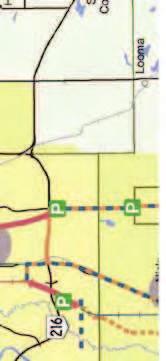
19 4.0 Regional Transportation Integration Integration of Strathcona County s transportation system with the transportation strategies and jurisdictional plans of the surrounding region is one of the guiding principles identified for this ITMP. This chapter outlines aspects of the regional transportation system that have been considered and incorporated where appropriate in the Strathcona County ITMP, as well as some strategic directions and actions recommended for the County itself. 4.1 Context Capital Region Board (CRB) Integrated Regional Transportation Master Plan (IRTMP) The Capital Region Board IRTMP is intended to identify a regional transportation system that serves regional needs while supporting the Capital Region Growth Plan. The IRTMP s guiding themes are: Integration with the Capital Region s Growth Plan Preserve the integrity of priority growth areas Maximize use of existing infrastructure Develop a transportation system that supports the region s economy Increased transportation choices Provide viable alternatives to private automobile travel Support active transportation Support multi-modal transportation Reduce environmental degradation Minimize impacts associated with the transportation network Coordinate infrastructure between all jurisdictions The CRB approved the IRTMP 2044 roadway network (see Figure 4.1) in September 2011, with the provision that the location of the north/south connector upgrade shown as Highway 830 is to be confirmed based on consistence with the conclusions of the Highway 16 Planning Study (undertaken by Alberta Transportation). 12


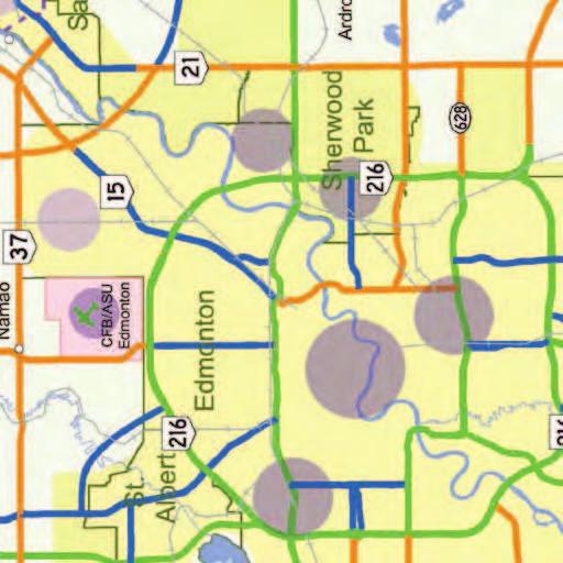

20 Figure 4.1 CRB 2044 Road Network 13
21 Intermunicipal Transit Network Plan In 2009 the CRB approved the Capital Region Intermunicipal Transit Network Plan to provide guidance to the Capital Region for regionally integrated and coordinated transit service planning and delivery. As shown in Figure 4.2, the plan divides the Capital Region into zones with different service levels based on their distance from central Edmonton. Sherwood Park and the County s future urban growth areas are part of the suburban zone, where regional service is to be designed based on a timed transfer network with frequent service to downtown and the University of Alberta. The County s Rural Service Area is in the exurban and rural zones where transit service will be minimal. The IRTMP-approved 2044 regional transit network is shown in Figure 4.3. Strathcona County Transit currently provides intermunicipal transit service to the University of Alberta and downtown Edmonton via the Sherwood Park Freeway and Baseline Road corridors. In the medium term future, the CRB intermunicipal transit plan envisions the possible addition of commuter service on Highway 16 connecting to an LRT station in Edmonton. In the long term, commuter transit is envisioned to north and southeast Edmonton, along with an LRT line connecting central Edmonton to Strathcona Transit Centre. The CRB transit plans aligns well with the County s existing intermunicipal transit service; service to future urban growth areas will need to be examined as area planning proceeds Alberta Transportation Provincial Highway Network Among other things, Alberta Transportation is mandated with creating and maintaining a highway network to facilitate the movement of people and goods through and within the province. In the context of the Capital Region, the provincial highway network connects Strathcona County to Edmonton and other area municipalities, as illustrated in Figure 4.4. The construction and maintenance of these network highways fall under provincial jurisdiction. The province strives to provide a high level of service for vehicles on highways. As such, Alberta Transportation has a defined role in monitoring and controlling land uses adjacent to highways, and particularly plays a role in defining/restricting access onto highways. Provincial highway planning also has a defining role in establishing the spacing and location of interchanges accessing the highway system. In Strathcona County, this creates challenges in developing a connected municipal road system, particularly in the context of future urban growth areas. For example, growth areas adjacent to Highway 16 or Highway 21 are subject to stringent limitations on access to such highways which are planned as provincial expresswayand freeway-standard facilities. However, Alberta Transportation is open to coordinated planning of highways with municipalities, and recognizes the impacts and importance of doing so. 14


22 Figure 4.2 CRB Transit Development Zones 15


23 Figure 4.3 CRB 2044 Intermunicipal Transit Network 16


24 Figure 4.4 Provincial Highway Network 17
25 Regional Ring Road A Regional Ring Road Corridor Identification Study was initiated by Alberta Transportation in 2011 with a timeline of several years to complete. The stated intent of the regional ring road would be to allow for efficient movement of goods and people within and across the region and the province. The study area in the project terms of reference, for the section within Strathcona County, covered a broad area between Highway 21 and Highway 824 and would cross the North Saskatchewan River south of Fort Saskatchewan. The study area also covered the Urban Reserve area identified in Strathcona County s MDP and would have potential to conflict with future development in the Northeast UGA. Alberta Transportation commenced this corridor identification as a possible pre-cursor to acquiring property to reserve a corridor for long-term transportation needs. It was understood that if a regional ring road is eventually warranted, construction would not commence for at least thirty years after the completion of the study. In 2011, the CRB approved the Integrated Regional Transportation Master Plan (IRTMP) and the associated Integrated Regional Transportation System Study (IRTSS), which conclude that a regional ring road is not needed in the thirty five year time frame and recommend that the province not pursue planning for such a facility (Strathcona County supported this position). Alberta Transportation has accepted these plan recommendations as the basis for further development of the long term provincial highway network in the Capital Region. However, the ITRMP/IRTSS do contain a number of recommendations for roadways which are similar to the regional ring road concept, such as a new roadway crossing the North Saskatchewan River between Anthony Henday Drive and Fort Saskatchewan. Further discussion between Alberta Transportation and the CRB will be required in order to clarify and align the regional and long term provincial transportation plans City of Edmonton Transportation Master Plan The City of Edmonton updated its Transportation Master Plan in Figure 4.5 depicts Edmonton s transportation master plan concept for the year The 2040 concept envisions further expansion of LRT, with up to six lines radiating from the downtown core, and park-and-ride facilities at the extremities of the city or within the TUC. One of the future LRT lines would extend east toward Sherwood Park, if warranted. As of 2012, the City of Edmonton has commenced planning and/or construction on the Edmonton components of five of the LRT legs in their Plan, but not the corridor to the east. The Edmonton Transportation Master Plan commits the City to working within the CRB structure to cooperatively plan and implement improvements to both roads and transit. 18
 (Existing or Under Construction) Proposed Anthony Henday Drive (Province Of Alberta) Inner Ring Road and")
26 Figure 4.5 Edmonton TMP Concept Anthony Henday Drive (Province Of Alberta) (Existing or Under Construction) Proposed Anthony Henday Drive (Province Of Alberta) Inner Ring Road and Highway Connectors Provincial Highway Connectors Potential LRT Extension Potential Interchange Point LRT (Existing, Under Construction or Approved) FOR INFORMATION PURPOSES ONLY 19
27 There are three existing east/west provincial highway connectors leading from central Edmonton into Strathcona County. These highway connectors have a more free-flowing design standard with limited access, and are intended to serve both regional and Edmonton traffic. Yellowhead Trail (Highway 16) connects to the north portion of the Sherwood Park USA. Sherwood Park Freeway aligns with the southern edge of the Sherwood Park USA. Whitemud Drive (Highway 628) forms the northern border of the proposed Colchester UGA and is located south of the Sherwood Park USA. Anthony Henday Drive provides access from Strathcona County to southeast Edmonton (and will also link to northeast Edmonton when completed in approximately 2016). Regional Travel Model (RTM) The RTM is a travel demand model maintained by the City of Edmonton in collaboration with Alberta Transportation and the CRB, and encompasses the entire Capital Region. The model uses population, employment, and education forecasts prepared by the CRB to predict future travel demand within and between regional municipalities including Strathcona County Other adjacent municipalities Fort Saskatchewan The City of Fort Saskatchewan is located north of the Sherwood Park USA and bordered by the North Saskatchewan River and Strathcona County. Its primary connection to the County is via Highway 21 to the south leading to the Sherwood Park USA, and Highway 15 to the north leading to the Industrial Heartland. Fort Saskatchewan and Strathcona County have a long-standing working relationship seeking solutions to intermunicipal transportation issues such as the magnitude of heavy truck traffic on Highway 15 through Fort Saskatchewan and possible re-routing options that may impact Strathcona County. Beaver County Beaver County is located south and east of Strathcona County. The main connection between the two counties is Highway 14, which extends south-east to Tofield and other towns in Beaver County. Lamont County Lamont County is located to the northeast of Strathcona County. The main connections between the two counties are Highway 16 to the east, and Highway 15/Highway 21 through Fort Saskatchewan. 20
28 Sturgeon County Sturgeon County is located north of Strathcona County, across the North Saskatchewan River. The main connections between the two municipalities are Highway 15 through Fort Saskatchewan, and Highway 38 via the Vinca Bridge at the northernmost edge of Strathcona County. Leduc County Leduc County is located south and west of Strathcona County. Highway 21 and Township Road 510 connect the two counties, and Anthony Henday Drive and Highway 2 (through Edmonton) also provide a direct connection to Edmonton International Airport and the City of Leduc (which are located within Leduc County) Alberta s Industrial Heartland Alberta s Industrial Heartland Association (AIHA) is a partnership of the City of Fort Saskatchewan, Lamont County, Strathcona County, Sturgeon County, and the City of Edmonton, with a mandate to jointly promote and facilitate the industrial development of the Heartland area, generally for chemical, petrochemical, oil, and gas projects. A Transportation Analysis and Needs Study was initiated in late 2009 by the AIHA to examine the traffic impacts of proposed industrial developments, along with recommended transportation mitigations. The study included a sensitivity analysis of several growth scenarios and concluded with the following recommendations. Policies be established to ensure that 70% of all on-site construction workers at major projects be bused to site. A comprehensive system of park-and-ride locations be studied and implemented for the Capital Region that ties into existing road and transit systems. (Potential parkand-ride facilities within the County for industrial workers will likely be located close to the Sherwood Park USA.) Priority road system improvements (within Strathcona County) at: Highway 15 (Highway 830 to west of Range Road 213) Highway 45 (extending alignment straight south to Highway 15, thus avoiding Bruderheim) The study also recommended that a suitable roadway network be developed to provide connectivity options in the area of Fort Saskatchewan, to distribute traffic oriented to/from the Industrial Heartland. 21
29 4.1.6 Airports & railways Numerous air and rail transportation facilities exist within, and in the vicinity of, Strathcona County, as illustrated in Figure 4.6. Airports The main airport within the Capital Region is Edmonton International Airport (YEG). A route to the airport from the County with a high level of service is required to support economic development as well as general mobility of people and goods. Access to YEG is currently available via AHD and Highway 2. Alternate routes to the airport include Highway 21 and Highway 625, which are designated as expressways in the CRB s IRTMP. In the long term, access may be provided via the Alberta Transportation - Regional Ring Road if constructed. Adjacent to YEG is Port Alberta, an initiative of Edmonton Airports as an industryled association supported by various levels of government, which seeks to promote the creation of world class transportation, logistics, and supply chain intelligence to link the Alberta economy to the world. Port Alberta has committed to exploring opportunities related to the Industrial Heartland and to resource development areas in northeast Alberta. With continued development of the Capital Region and YEG into a logistics hub, traffic volumes on some Strathcona County roads will likely increase. Two other regional airports lie within Strathcona County. The Cooking Lake Airport is located southeast of the Sherwood Park USA and is primarily a recreational flying facility operated by Edmonton Airports. The Josephburg Airport (Warren Thomas Aerodrome) is northeast of the Sherwood Park USA and is operated by Strathcona County. It serves both privately-owned and commercial aircraft, and has been used to transport workers into the Industrial Heartland; as development proceeds in the Industrial Heartland it is likely to grow in importance. Traffic on Highway 830, the main road connecting Josephburg to the Industrial Heartland and areas to the south, is likely to grow in conjunction with growth in airport activity. Railways Both Canadian National Railways and Canadian Pacific Railways operate railway lines within Strathcona County. These rail lines are a context factor that will affect land use design and directions, such as within the proposed Northeast UGA or the North of Yellowhead ACP. The rail line will act as a barrier to other travel modes and its effects on active transportation modes will need to be considered. In areas where development occurs, increased road traffic may eventually warrant road-rail grade separations, and associated rail noise and traffic impacts will need to be mitigated. 22


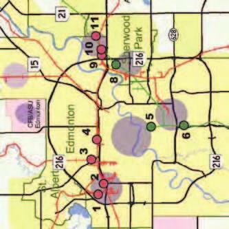

30 Figure 4.6 Airports & railroads 23
31 4.2 Strategic Directions To support the guiding principle of integration of Strathcona County s transportation system with the transportation strategies and jurisdictional plans of the surrounding region, the following strategic directions are recommended. A. Work with the Capital Region Board on implementation of regional plans in support of County and CRB objectives. B. Work with Alberta Transportation on planning provincial transportation facilities which support County and regional priorities. C. Work with Edmonton to coordinate inter-municipal plans and optimize multi-modal connections including roads, transit, and appropriate active transportation infrastructure. D. Work with Fort Saskatchewan to coordinate inter-municipal plans and support multi-modal transportation options, particularly for the growth hamlet of Josephburg. E. Work with private, public, and non-government sector partners to implement plans in support of Alberta s Industrial Heartland. F. Work with rail and air transportation facilities to consider regional operational and access needs in County transportation decision-making. It should be noted that there are other regional partners with whom working together will also be beneficial, and the specific strategic directions above are not intended to exclude such additional regional cooperation. 4.3 Strategic Actions This section identifies recommended priority actions at a strategic level, in support of the strategic directions arising from the ITMP. Additional specific recommendations are listed below the strategic actions, where appropriate Confirm mechanisms for working with identified regional parties Timeframe: Short Medium Long Applicable Geographic Areas: USA UGA(s) Rural Review and enhance (or establish, if necessary) effective mechanisms for working with identified regional parties, with regard to implementing ITMP strategic directions and overall Strathcona County strategic plan objectives. The most relevant regional parties include the Capital Region Board (CRB), Alberta Transportation, City of Edmonton, City of Fort Saskatchewan, and Alberta s Industrial Heartland Association. 24
32 Recommended specific activities include the following: (a) Seek key committee appointments and cultivate effective working relationships. (b) Ensure that all County representatives are well-versed in the ITMP vision and strategy in order to effectively influence decisions. (c) Formalize and promote regular (e.g. quarterly) scheduled meetings of County administrative and political leadership with equivalent leaders for regional parties with decision-making authority affecting Strathcona County (e.g. CRB, Alberta Transportation) Establish key priorities for working with Capital Region Board Timeframe: Short Medium Long Applicable Geographic Areas: USA UGA(s) Rural Recommended specific activities include the following: (a) Advocate for actions in support of the Council-approved ITMP transportation system plan in CRB committees such as Land Use and Transit Establish key priorities for working with Alberta Transportation Timeframe: Short Medium Long Applicable Geographic Areas: USA UGA(s) Rural Recommended specific activities include the following: (a) Engage with Alberta Transportation and other provincial agencies to ensure that future transportation plans, such as a potential regional ring road, will match the County s ITMP, MDP and other strategic plans. (b) Determine how the future provincial highway network, with support from the local network, will be capable of accommodating traffic from the UGAs and the Industrial Heartland. (c) Add an agenda item regarding transportation at the recurring meetings between County senior executives and provincial Assistant Deputy Ministers and Deputy Ministers. (d) Define appropriate access and service level parameters for provincial highways identified in the ITMP as part of the County road network. (e) Maximize grants to be obtained from Alberta Transportation, and work with Alberta Transportation to jointly acquire maximum grants from the Government of Canada. (f) Ensure the County s growth and service level objectives are not unduly compromised by access management and freeway development objectives, in particular for Highway 16 and Highway
33 4.3.4 Establish key priorities for working with City of Edmonton Timeframe: Short Medium Long Applicable Geographic Areas: USA UGA(s) Rural Recommended specific activities include the following: (a) Participate actively on relevant joint planning committees. (b) Participate actively in inter-jurisdictional planning (e.g. 17 Street, 34 Street) Establish key priorities for working with City of Fort Saskatchewan Timeframe: Short Medium Long Applicable Geographic Areas: USA UGA(s Rural Recommended specific activities include the following: (a) Participate actively on joint planning committees such as the Intermunicipal Relations Committee, and continue development of the Regional Collaboration Project to advance the definition of cooperative processes with the City of Fort Saskatchewan. (b) Seek resolution to intermunicipal transportation issues such as the magnitude of heavy truck traffic on Highway 15 through Fort Saskatchewan and possible re-routing options that may impact Strathcona County Establish key priorities for working with Alberta s Industrial Heartland Timeframe: Short Medium Long Applicable Geographic Areas: USA UGA(s) Rural Recommended specific activities include the following: (a) Develop a suitable roadway network to provide connectivity options to distribute traffic oriented to/from the Industrial Heartland. 26

.")
34 5.0 Land Use Integration Closer integration of transportation and land use is one of the guiding principles identified for this ITMP. 5.1 Context Background The objective of integrating land use with transportation is fundamental to planning. Transportation and land use have long been understood to be functionally interconnected, but conventionally in practice they often have been dealt with as two related but compartmentalized aspects of planning, building, and operating a municipality. In the past, transportation decisions often have driven land use outcomes (even where solid land use plans exist). In contrast, smart growth and similar approaches hold that community features and characteristics should be defined in terms of desired land uses and form, and then the transportation system is to be developed in support of the community-building objectives. In practice, a balanced and integrated approach is optimal. Coordinating land use and transportation requires consideration of the effect of land use decisions on the transportation system and vice versa. Land use decisions can help or hinder access to employment, the purchase of goods and services, and community resources that will improve the quality of residents lives. Likewise, current and future transportation infrastructure influences the demand for land and its patterns of use and development. To sustain and enhance natural resources and create healthy communities, integrated land use and transportation planning is considered a part of the smart growth concept. This includes providing a mix of uses in the community (residential, retail, recreation, employment) that take into account the importance of geographic proximity and the integration of the different uses into the neighbourhood. The longer term impacts of these land use decisions on the environment are also critical to consider. A compact settlement pattern that is supported by an efficient public transit system and good infrastructure for pedestrians and cyclists can help to meet sustainability goals, decrease energy use, reduce greenhouse gas emissions, conserve land and natural resources, and aid in the creation of unique and accessible communities. 27
35 Strathcona County was settled as a rural community, with associated low densities and long travel distances to reach services, employment, school, etc. Much of the urban centre of Sherwood Park was built in the latter half of the twentieth century, at a time when the private automobile was particularly dominant in society and in town planning, and at a time when Sherwood Park was primarily a bedroom community with residents commuting to Edmonton for work. The combination of low-density rural and car-oriented urban development history means that the desired transition to a more sustainable community will require innovative thinking, longer-term planning, and significant advancements in transit-oriented development and use of public transit and other alternatives to the low-occupancy motor vehicle. Such approaches will need to be customized to the unique characteristics of the geographic areas of the County (e.g. urban versus rural areas). Looking ahead to potential high-speed transit that would access Sherwood Park, transit-oriented development (TOD) has great potential in higher-density neighbourhoods next to express or high-speed transit. The construction of higher density neighbourhoods along key corridors can help set the stage for (and demonstrate the viability of) high-speed transit. As well, the introduction of express or high-speed transit at an early stage of development helps neighbourhoods not to become car dependent Strathcona County Municipal Development Plan (MDP) Strathcona County s 2007 Municipal Development Plan (MDP) sets out parameters for orderly growth and development over the next 20 years and beyond. Figure 5.1 shows MDP Map #12, which defines policy areas comprising the plan framework. The MDP acknowledges that the County has traditionally developed with limited consideration for the long-term negative social, environmental or economic impacts on the community but incorporates a strong future direction toward sustainability and growth management objectives and policies. The MDP transportation policies are meant to improve the sustainability of development within the County and include the following: Working cooperatively with other levels of government to develop an integrated multi-modal transportation network that will meet the needs of individuals, business, and industry. Promoting transportation demand management initiatives such as car-pooling, public transit, walking, bicycling and working from home. Providing affordable, efficient transportation alternatives in the Sherwood Park USA. Reducing the amount of vehicle trips and kilometres travelled by promoting mixeduse developments, walkable communities and compact residential developments. Providing safe and efficient traffic routes for pedestrians, cyclists and vehicles. Providing and upgrading regional transit service to Edmonton (including possible expansion of Edmonton s high-speed transit system to Sherwood Park), and provide suitable local transit service within the Sherwood Park urban area. 28

36 Figure 5.1 Municpal Development Plan 29
37 5.1.2 Capital Region Growth Plan The 2009 Capital Region Growth Plan aims to integrate and coordinate growth within the Capital Region. The land use plan lays out a strategy to manage growth to minimize the Region s footprint based on Transit Oriented Development and densification of existing developed areas. These goals align well with the principles of Strathcona County s MDP. Population and employment forecasts are an integral part of the Capital Region Growth Plan. The Growth Plan projections show that the population of Strathcona County is expected to grow from about 88,000 (2009) to about 132,000 by 2044, equivalent to an annual growth rate of 1.2%. This is slightly lower than the 1.3% average for the Capital Region as a whole (and is also lower than the County s own growth projections). Population growth estimates for Strathcona County are based on density targets that have been allocated for each of the municipalities in the Capital Region. The Capital Region Growth Plan directs new growth within Priority Growth Areas (PGA) by planning for intensive forms of development that exceed existing density patterns in these areas. The priority growth areas identified in the CRB Capital Region Growth Plan, as they relate to Strathcona County, are shown in Figure 5.2. Sherwood Park and the future Colchester UGA are both located within PGA B, which has a density range midpoint of 37.5 dwelling units per net residential hectare 4. The future Northeast UGA is located within PGA F and has a density range midpoint of 35 dwelling units per net residential hectare. PGA S consists of cluster country residential and has a density target of 2.0 dwelling units per gross residential hectare. 4 pertaining to areas outside of downtown Edmonton 30


38 Figure 5.2 CRB Priority Growth Areas In Strathcona County 31
39 5.1.3 Sustainable planning initiatives The principles and policies of the MDP have been moving forward demonstrably via the planning and development of both the Emerald Hills Urban Village (based on SuNLIVING methods) and Centre in the Park (which emphasizes a diversity of housing and employment choices along with the use of technology to reduce energy and resources). Current work is also being undertaken to reflect density targets established by the CRB Capital Region Growth Plan. Some initiatives are achieving success because they are based on cooperative efforts among the public sector (i.e. Strathcona County), the private sector (i.e. developers active within the County), and the non-governmental sector (e.g. The Natural Step). Examples of more-sustainable planning initiatives include the following. Emerald Hills Urban Village Emerald Hills Urban Village is a 20 hectare mixed-use development planned for a community in Sherwood Park, south of Highway 16 and west of Clover Bar Road. The plan promotes a range of employment, business, and housing choices for residents and workers. The housing mix includes townhomes, duplexes, condominiums, and seniors apartments along with a long-term care facility. It is the first project to apply the SuNLIVING approach for sustainability and sustainable living concepts in Strathcona County. Cambrian Crossing Cambrian Crossing Area Structure Plan (ASP) is a plan for mixed-use development located north of Highway 16 and west of Highway 21, within the North of Yellowhead Area Concept Plan. Approved in early 2011, the ASP places a variety of housing types, from single family homes to apartments, within close proximity of schools, retail, mixed-use nodes and industrial developments. The development of a grid-like road network, along with multi-use trails within and across Oldman Creek, will encourage bicycle and pedestrian modes by connecting shopping and employment opportunities to residential areas. The ASP targets an average density of 38 dwelling units per net residential hectare. Salisbury Village The Salisbury Village Area Structure Plan (ASP) is located south of Wye Road between Brentwood Boulevard and Sherwood Drive. Salisbury Village is intended to be a compact development that results in a mixed-use village centre (with residential and retail/office developments) infilling the area between commercial development to the west and a business park to the east. The ASP aims to provide services and employment opportunities close to residential areas, and connect them with a comprehensive trail system and other amenities to encourage active transportation and transit; specific elements include ensuring suitable bicycle parking and bus stops within 400 m of residences. 32
40 Centre in the Park Centre in the Park (CITP) is in process of becoming the central hub of Sherwood Park, creating an office, retail, commercial, entertainment, and cultural focus, supported by higher density housing. CITP is planned as a sustainable community development, designed to be walkable, with good transit connections and limited parking. The core development area, with retail, apartments, and offices, is linked to existing amenities such as Broadmoor Lake Park and Festival Place. The anchor building for the development is the Community Centre, which opened in December of Country Residential Area Concept Plan (CR-ACP) The Strathcona County Municipal Development Plan includes an area defined as Country Residential Policy Area. The task of defining a more-specific future form for this area was catalyzed with the approval of the CRB Capital Region Growth Plan. In 2012, Strathcona County completed the Country Residential Area Concept Plan (CR-ACP). Although it is recognized that country residential development is not normally considered a sustainable form of development, it is a land use the County has allowed in the past and will continue to allow in the future. As such, one of the key objectives of the CR-ACP is to direct and accommodate country residential development within a specific area of the County in a manner that more-closely follows the overall sustainability objectives of the County. In order to fulfill the density requirement of the Capital Region Growth Plan, the CR-ACP has been divided into two areas. High Density Country Residential Area: this is the portion of the Country Residential Policy Area located just to the south of Sherwood Park and falls under Priority Growth Area S (Cluster Country Residential Area) in the Capital Region Growth Plan. It is expected to achieve a density of 2.0 dwelling units per gross hectare (which is equivalent to 129 parcels per quarter section). Low Density Country Residential Area: this is the portion of the Country Residential Policy Area located to the east of Highway 21, roughly between Highway 16 to the north and Township Road 522 to the south. The targeted density is 50 parcels per quarter section (which is equivalent to 0.77 dwelling units per gross hectare). In combination with the increased density targets, piecemeal development will be reduced by requiring an area structure plan for an entire quarter section even if only a small portion is to be developed. 33
41 5.2 Stategic Directions To support the guiding principle of closer integration of transportation and land use, the following strategic directions are recommended. A. Coordinate land use, transportation, and other infrastructure plans in a way that supports the wider community vision. B. Pursue goals and strategies for land use that facilitate the use of more sustainable transportation modes (e.g. walking, bicycling, transit) C. Incorporate planning solutions that are context sensitive (e.g. geographic areas, desired community form), taking into account the long-term implications of land use decisions. D. Coordinate and integrate County transportation priorities with investments by private, public, and non-government sector partners so that broader community goals are achieved. 5.3 Strategic Actions This section identifies recommended priority actions at a strategic level, in support of the strategic directions arising from the ITMP. Additional specific recommendations are listed below the strategic actions, where appropriate Establish guidelines for integration of urban development and transportation Timeframe: Short Medium Long Applicable Geographic Areas: USA UGA(s) Rural This involves developing guidelines and policies to support balanced communities that are easy to move around within, and have a variety of integrated transportation options, including walking, bicycling, and transit. Building codes and site-level requirements of zoning may have provisions that can have important effects on transportation options and travel behaviour. Developments should ensure good connections between activities, and carefully place transit facilities to reduce travel times and lessen environmental impacts. Recommended specific activities include the following: (a) Intensify land use. Focus planning resources on residential and employment intensification around key transportation nodes, in particular on creating livable and unique places. (b) Increase mixed-use development. Focus mixed-use development projects on a limited number of locations in order to maximize the benefits of investment decisions. 34
42 (c) Encourage more compact, complete communities. Plan and implement future land development to support more-sustainable modes of transportation and reduce automobile dependency (e.g. shorter distances between destinations for daily/regular needs). (d) Apply sustainability principles to neighborhood design/built form Particularly in the future UGAs, where neighborhood design and built form can be shaped in a new direction, Strathcona County should promote active living/active transportation through neighborhood design. Substantial research and evidenced-based analysis has informed how neighborhood design and built form can contribute to transportation and community livability objectives. Examples include fused grid neighborhood street patterns (see CMHC) and neighborhood design based on road safety research (see Wei & Lovegrove, 2012). Supporting guidelines and enhancement programs, such as those in the Design and Construction Standards (Open Space Standards), should be applied to address aspects such as landscaping and beautification along streets, preservation of historic sites and buildings in support of mixed-use and walkability. Many building design features improve and increase active transportation opportunities. On commercial streets a variety of techniques can be applied which make the streets more interesting and active. The siting of a building on the lot can also influence active transportation. Moving parking lots from the front (between the curb and building façade) to the back or side of a building limits negative space and improves walking access. Clustering buildings, rather than building scattered with great distances between the buildings on their respective lots, reduces walking distances between buildings Introduce integrated transportation assessment guidelines Timeframe: Short Medium Long Applicable Geographic Areas: USA UGA(s) Rural These are intended to provide a means to ensure that a full assessment of transportation opportunities and constraints is undertaken, and any proposed development is consistent with regional planning and transportation policies. It involves looking at how development will interact with transportation networks, where constraints on traffic capacity may occur, the supply and demand for public transit, and the degree of accessibility of walking and bicycling networks. 35
43 5.3.3 Develop mobility hubs Timeframe: Short Medium Long Applicable Geographic Areas: USA UGA(s) Rural The goal of a mobility hub is to develop a central location where transit service, ride sharing, and end of trip facilities create an opportunity for users to change modes and move beyond the local area. The mobility hub should be central to the community and designed in a way that provides a point of interest and sense of place. The mobility hub should be designed so that pedestrians and cyclists can arrive to the hub and easily transition to rideshare or transit. The mobility hub should provide a safe comfortable area for users waiting between portions of their journey. Other key features of mobility hubs may include a transit exchange, park-and-ride, and/or carpool support. Mobility hubs are consistent with, and may be supported by, transit-oriented development (TOD) which typically involves higher-intensity mixed land uses in close proximity to high-quality transit service. However, in the context of some portions of Strathcona County (e.g. hamlets), similar principles of land use and transportation access can still be effective with lower-intensity transit, and/or supported by alternatives such as ride sharing. 36

.")
44 6.0 Transit 6.1 Context Improving public transit is one of the guiding principles identified for the ITMP. In the context of Strathcona County, transit currently provides service for travel within the Urban Service Area and for trips between the Urban Service Area and key destinations in the City of Edmonton. These services are mainly designed for people making trips for work or school. In the future, transit services could be designed to also connect the larger hamlets and rural areas to the Urban Service Area. They could also be designed to serve a wider range of trips (e.g. trips for medical visits, recreation, or shopping). Transit is most effective when it serves trips for which there is a significant volume of people traveling to and from the same locations at the same time. Transit services could also play a significant role in shaping land uses and in the attraction of development to specific locations. This could be especially true in the case of a future high-speed transit connection to Strathcona County. In general, attracting a larger transit mode share is a key to meeting the strategic goal of optimizing transportation expenditures and other aspects of sustainability County & regional transit plans In 2012, Strathcona County approved a new Transit Master Plan. This plan addresses the current transit needs of the community and provides a strategy for transit over the next ten years. It proposes solutions for both urban and rural residents. It is a response to growth in population and employment, known travel movements, an aging population, an expected increase in the cost of operating a car, and increased traffic congestion. The vision for transit developed in the Transit Master Plan is: As a recognized leader in the transit industry, Strathcona County Transit takes pride in providing excellent service to the community while enhancing quality of life and promoting sustainability. The plan indicates that transit service should serve 50 passenger rides per capita annually by the end of the ten-year period, as compared to the existing level of 39 passenger rides per capita annually. It will require the existing ridership base to be maintained and grow, as well as some new markets to be introduced. The Capital Region Board (CRB) has also developed an Intermunicipal Transit Network Plan. This section of the ITMP strives to be consistent with these plans and the above vision and expand on them by proposing actions that are linked to other aspects of the transportation system and addressing transit needs beyond the ten-year horizon of the Transit Master Plan. 37
45 6.2 Strategic Directions To support the guiding principle of improving public transit, the following strategic directions are recommended. A. Make transit an attractive, competitive alternative to the low-occupancy motor vehicle for commuter and local trips. B. Optimize transit linkages between Edmonton and the Sherwood Park Urban Service Area and any future urban growth area(s) through infrastructure, information, and service design. C. Improve transit service for local trips within the Sherwood Park Urban Service Area, and capitalize on integration with land use planning to support high-quality local transit service in future urban growth area(s). D. Assess the need for transit connectivity to the growth hamlets, possibly through development of small-scale mobility hubs. E. Assess the feasibility of high-speed transit between Strathcona County and Edmonton, then plan for any identified high-speed transit solutions accordingly. 6.3 Strategic Actions This section identifies recommended priority actions at a strategic level, in support of the strategic directions arising from the ITMP. Additional specific recommendations are listed below the strategic actions, where appropriate Implement the Transit Master Plan Timeframe: Short Medium Long Applicable Geographic Areas: USA UGA(s) Rural The Transit Master Plan, approved in 2012, addresses tactical aspects of improving public transit over the next decade. It is complementary to the ITMP transit strategy, which will extend over a longer-term timeframe. Implementation of the Transit Master Plan is an appropriate start toward the longer-term strategic actions of the ITMP. 38
46 6.3.2 Support future transit service levels with appropriate investments in roads, transit vehicles and facilities, and pedestrian and bicycle connections Timeframe: Short Medium Long Applicable Geographic Areas: USA UGA(s) Rural Recommended specific activities include the following: (a) Invest in transit services that will increase ridership. In order to substantially increase transit mode share in the short, medium, and long terms, Strathcona County Transit will have to strategically add services over the years. The Transit Master Plan indicates that intermunicipal services should be expanded over the next ten years to meet the needs of the community, particularly residents of the urban service area. Transit mode share for trips to work was 4.6% for the USA in 2006, and so there is likely room for growth. More intermunicipal services would increase ridership and better serve the existing ridership base made up of commuters and students. Furthermore, these intermunicipal services attract higher ridership and revenue than the local services, and so investing in them has the potential to raise overall transit system economic performance. These services can attract reverse commuters with the same services at minimal extra operating cost and with the proper fare levels, marketing, and land use development in both Edmonton and Strathcona County. Other means of increasing transit mode share are by increasing frequencies on the best performing (ridership/revenue) routes and serving more destinations. Smart buses/smart card technology can also support increased ridership. (b) Encourage the use of monthly or annual passes. The advantage of monthly and annual passes from the perspective of the transit agency is that they encourage transit usage because the marginal cost to the passenger of each additional transit trip is zero. Passes also reduce transaction costs related to the buying and selling of tickets. From the perspective of customers, this option often offers the most economical option and makes transit easier to use. Encouragement of the use of passes could be through employee passes, in which all employees at a certain business are provided with an annual transit pass as a benefit. They could also be offered through a community pass program in which all community members are provided with an annual pass as part of the cost of their home. U-Passes for staff and students are already available through Edmonton-area post-secondary institutions, including Strathcona County Transit a participating transit system. (c) Invest in transit customer information systems. Information is a transit trait highly valued by potential riders and is therefore an important consideration in attracting new customers to transit. In the year period, a CRB goal is to integrate all information related to transit in the Capital Region. This will presumably make information about all transit services in the entire Capital Region available in one place. Customer information systems could come in the form of public address systems, real-time arrival information, and website information, and make use of social networking platforms where it makes sense. 39
47 (d) Invest in accessible services and facilities. Accessibility investments tend to benefit all users and raise customer satisfaction. Providing accessible services and facilities will save the County money in the long run by reducing the costs of Strathcona County Accessible Transit (SCAT) services, by focusing specialized transit services for that segment of the population with the most-serious mobility or cognitive restrictions. Access to transit can be improved through means such as a complete sidewalk network and safe crosswalks, as well as through the transition to a fully accessible fleet. Facilities such as bus stops and park-and-ride locations should also meet guidelines related to slopes, widths, and customer information to become fully accessible. (e) Enhance connections with active transportation (e.g. bicycle racks on buses, sidewalk connections at bus stops, bicycle lockers/parking at transit centres) Incorporate transit priority within Strathcona County and support integrated transit priority initiatives elsewhere in the Capital Region Timeframe: Short Medium Long Applicable Geographic Areas: USA UGA(s Rural Transit priority can come in a wide variety of forms. For example, bus bulges (i.e. extending the curb out to the bus travel lane) can reduces delay at transit stops, transit priority signals and queue jumps can reduce delays at intersections, and exclusive bus lanes can reduce delays caused by other roadway traffic. Whenever roadway projects are undertaken in Strathcona County, they should consider any improvements for bus movements and passengers. Furthermore, transit priority initiatives elsewhere in the Capital Region should be promoted and supported to improve inter-municipal transit operations Consider economic levers to shift demand from driving to transit Timeframe: Short Medium Long Applicable Geographic Areas: USA UGA(s) Rural The County should establish policies that shift demand for low-occupancy motor vehicle trips to transit trips through economic incentives/disincentives. Recommended specific activities include the following: (a) Charge for parking or introduce a tax on parking spaces, especially in areas that are well served by transit. (b) Consider (in the longer term) road tolls, increased car registration fees, and increased gas taxes for Strathcona County within the framework of the Capital Region as a whole. In addition to reducing automobile demand, these actions could also raise revenues for improving transit services. Partnership with the provincial and/or federal government would likely be necessary regarding these types of initiatives. 40
48 6.3.5 Encourage ridership with transit-friendly land use planning Timeframe: Short Medium Long Applicable Geographic Areas: USA UGA(s) Rural It is important to encourage dense, mixed-use development in the urban growth areas and growth hamlets around the County, as these can generate the trip volumes needed to support high-quality transit services. Also, increasing densities in existing transit service corridors can help improve the economic performance of existing transit services. Smart land uses around the current transit hubs in the urban service area (i.e. Sherwood Park Transit Centre and Strathcona Station) can also help improve the performance of the transit services. 41


49 7.0 Active Transportation 7.1 Context Increasing transportation mode choice is one of the guiding principles identified for the Integrated Transportation Master Plan. In addition to public transit, bicycle transportation and pedestrian transportation are among the most feasible alternative modes of transportation for Canadian municipalities. This chapter identifies strategies for increasing mode choice to active transportation modes (primarily walking and bicycling), which should in turn result in increases in mode share for a range of human-powered alternatives to the low-occupancy motor vehicle. Bicycling and walking serve numerous functions. In addition to providing recreational opportunities, they are also important forms of transportation for both commute and non-work trips (e.g. shopping trips). As well, bicycling and walking can help promote more active and healthier lifestyles. People who incorporate bicycling and walking into their daily lives have better health and lower risk of chronic disease. In addition, it can also be used as a tool for promoting tourism for a particular area and for attracting more patrons to a commercial area, as cyclists and pedestrians are more likely to visit multiple businesses per trip and they shop more often than someone who drives. As a result, they bring economic benefits Bicycle transportation Bicycling allows a person to travel longer distances faster than walking, and can offer a viable alternative to the automobile mode in many circumstances. According to Edmonton s 2005 Household Travel Survey, two-thirds of all bicycle trips in that city are in the range of 2 km to 10 km long. Remarkably, about one-third of automobile trips in Edmonton were recorded in that same range of 2 km to 10 km long, indicating a significant number of trips where the choice of bicycle transportation is a realistic alternative. The areas of Strathcona County where this finding is transferable will tend to be within urban areas with shorter distances and greater concentration of destinations and activity centres (including transit hubs). This includes existing Sherwood Park, any future urban growth areas, and the three growth hamlets. Some activity centres in the Capital Region are within 10 km of some areas of Strathcona County; also, some bicyclists are willing and able to make trips longer than 10 km. As such, provision of bicycle route facilities in cooperation with adjacent municipalities (such as Edmonton and Fort Saskatchewan), and possibly Alberta Transportation for some alignments, can encourage longer-distance bicycling between municipalities. 42
50 Also for longer-distance trips, bicycles can play a role when integrated with transit. Bicycles can serve as an appealing mode to access transit service or transit centres, especially if bicycle parking and other supportive facilities are available. The effective range of travel by bicycle can also be indefinitely extended if public transit (on buses with bike racks) is available as an intermediate mode between bicycle segments at the origin and destination ends of a trip. To support a safe and efficient bicycle transportation system, the urban areas of the County will benefit from additional well-located and well-designed bicycle routes, as well as increased availability of bicycle parking and other end-of-trip facilities (e.g. lockers, showers, washrooms). Providing more bicycle facilities tends to result in more trips by bicycle. For example, a 2010 report by CMHC (Canada Mortgage and Housing Corporation) suggests that communities with facilities oriented towards cyclists are more likely to have residents who bicycle for recreation, work, and other purposes. Bicycle routes include off-road paths and trails, as well as on-street facilities which may or may not be physically protected from vehicular traffic. Cyclists who are accustomed to riding in high traffic environments can also be found on highways and local streets that have no special facilities designated for bicycling. Thus, all roadways are a critical part of the bicycling network and need to be maintained so that cyclists can use them safely and comfortably Pedestrian transportation Being a pedestrian is the simplest and most sustainable form of transportation, and virtually every trip involves walking as a component. Investment in pedestrian infrastructure, therefore, improves the community for everyone. While many different types of terrain can be travelled by foot, residents using strollers, wheelchairs, or other mobility aids may require additional features to be considered in the installation of the pedestrian network. Thus, access and barriers to pedestrians of all abilities is an important consideration. Building a pedestrian network requires building for pedestrians who require the highest standard of facility (e.g. curb ramps, minimum width of sidewalk space, surface texture changes etc.). In addition to providing adequate, safe, and clean spaces and surfaces for pedestrians, the presence of other pedestrian facilities is important. Such facilities, which include pedestrian crossings and signals, appropriate lighting, shading, landscaping, seating, garbage receptacles, wayfinding signage, and access to water fountains and restroom facilities, improve the comfort of pedestrians and encourage walking. Also, walkability is impacted by land use patterns (the more diverse a street is, the more interesting it is for a pedestrian to walk through), building accessibility, and access to public transit. In North America, most trips on foot are less than one kilometre. Therefore, having more compact communities where residents can access employment, education, groceries, public transit services and other daily services by foot greatly increases the walkability of a municipality. 43
51 7.1.3 Other active transportation modes There are many other modes of active (or human-powered) transportation that are used occasionally or regularly in addition to bicycling and walking. Examples include jogging, skateboarding, roller blading, unicyling, or cross-country skiing (seasonally), to list a few. However, most of these other active modes are a smaller proportion of the human-powered transportation mode share, and in most cases improvements and facilities in support of bicycling or walking will also benefit the other human-powered modes Trails strategy In 2012, Strathcona County approved an updated Trails Strategy, which will guide trail planning, design, construction, operations, and maintenance, based on a balance of recreational and active transportation uses. The strategy establishes a long-term vision and direction toward a safe, accessible and innovative trail system for both rural and urban areas in Strathcona County. Relative to the transportation function of trails, the guiding principles for the Trails Strategy include the following: Trails provide opportunities for active transportation. Trails are important to the quality of life of both urban and rural Strathcona County residents. Trails are key components of walkable communities and act as a catalyst for community connectedness. 7.2 Strategic Directions To support the guiding principle of increasing transportation mode choice, the following strategic directions are recommended relative to bicycle and pedestrian transportation. A. Create a more-connected framework for bicycle transportation, with identified key routes traversing the County, and greater connectivity within and between urban areas. B. Support and increase community walkability, especially in the Sherwood Park Urban Service Area, future urban growth area(s), and the growth hamlets. C. Implement facilities and programs to increase bicycling and walking mode shares. 44
52 7.3 Strategic Actions This section identifies recommended priority actions at a strategic level, in support of the strategic directions arising from the ITMP. Additional specific recommendations are listed below the strategic actions, where appropriate Confirm/implement policies and practices supporting active transportation Timeframe: Short Medium Long Applicable Geographic Areas: USA UGA(s) Rural Recommended specific activities include the following: (a) Implement the Trails Strategy. The Strathcona County Trails Strategy was adopted by Council in 2012, and the ITMP supports implementing aspects of the Trails Strategy that are related to active transportation in particular. (b) Enhance network of bicycle routes. To increase transportation mode choice and the bicycle mode share, the County s long-term plan should therefore include a network of well-connected bicycle routes. The first priority would be to develop continuous east-west and north-south bicycle routes across the County, and across Sherwood Park and plan them into the urban growth area(s). The County should also ensure there are safe commuter bicycling connections between Edmonton and the County. In the longer term, the County should also connect other isolated bicycle route segments and improve linkages between the North Saskatchewan River valley and nearby residential areas, and between Sherwood Park and the adjacent areas in the east and south. These improvements should also be accompanied by increased signage for wayfinding purposes and to increase the visibility of cyclists to motorists and remind motorists of speed limits. In the longer term, to help the County optimally locate bicycling infrastructure in areas that are currently underserved, a bikeability index could be built for the County (or even better, the whole Capital Region) based on five components: bicycle route density; bicycle route separation; connectivity of bicycle-friendly streets; topography; and destination density. Such an index has been developed for Metro Vancouver by a team of University of British Columbia researchers, and is to be expanded to include ten other municipalities in Canada (Victoria, Calgary, Saskatoon, Winnipeg, Toronto, Montreal, Halifax, Charlottetown, Moncton, and St John s). 45
53 (c) Promote the installation of bicycle parking and supporting end-of-trip facilities Bicycle end-of-trip facilities include secure and convenient bicycle parking, as well as supporting infrastructure such as showers, lockers, change rooms, and washrooms. These facilities allow users to transition from riding (or walking) to work or other activities. There are generally two types of bicycle parking: short-term parking, which usually includes simple bicycle racks or stands with limited weather protection; and long-term parking, which is usually partially- or fully-enclosed or indoor to provide more protection against the elements and against theft. Supporting features mentioned above are also often provided with long-term parking. Currently, the County Land Use Bylaw specifies bicycle parking requirements for new buildings and for buildings where there is a change in use or there is an expansion. For example, the number of long-term bicycle parking spaces required for apartment buildings and institutional buildings is 5% of the number of vehicular parking spaces. Each building also needs to have six short-term bicycle visitor parking spaces. For multi-family residential this is quite low and does not encourage bicycling for residents because many of them will not have secure bicycle storage. Strathcona County should consider increasing their bicycle parking requirements, particularly for the urban areas where bicycling is a viable alternative to driving for residential, office and commercial properties. As well, the County should consider opportunities to install bicycle racks that add to the aesthetic of the street (e.g. bicycle racks that are designed as pieces of public art). Furthermore, there are no requirements to include supporting features when long-term bicycle parking is provided. To make bicycling more attractive, the County should amend the Land Use Bylaw to require washrooms, showers, lockers, and change rooms to be included in non-residential buildings in association with long-term bicycle parking. To encourage developers to include more end-of-trip facilities, vehicular parking requirements could be reduced if bicycle facilities are included in a new development. Especially applicable for multi-family residential, retail, office and institutional land uses, some jurisdictions allow developers the opportunity to provide fewer vehicle parking spaces if they provide defined levels of bicycle parking, supporting end-of-trip facilities and/or are located near good-quality public transit. (d) Pilot techniques to provide safer, more comfortable, and convenient bicycling environments. The County should pilot techniques to provide safer bicycling routes and should monitor the success of these new techniques to determine if they should be used permanently. Such techniques may include bicycle boulevards, which are low-volume, low-speed shared roadways that often feature traffic calming features and discourage through-vehicle traffic, but still allow local motor vehicle traffic. The intent is to provide a safe and comfortable bicycling environment that is welcoming to all ages and skill levels. 46
54 Bicycle boxes (consisting of advanced stop bars and bicycle activated traffic signals) can also be piloted at intersections along key bicycle corridors. Bicycle boxes are relatively easy to implement, help reduce turning conflicts between cyclists and motorists at intersections, and help position cyclists for left-turns, while increasing the visibility of cyclists to motorists. Bicycle-activated signals help cyclists cross intersections more easily through the use of loop detectors or push-buttons and can help reduce cyclist delay. As these techniques are usually more useful for higher traffic areas, in the case of Strathcona, they would mainly apply to the urban areas. (e) Build missing sidewalks and trails While many urban residential streets within Strathcona County currently have sidewalks, there are still communities such as the Estates of Sherwood Park without sidewalks. Also, while today the rural residential areas of the County may not have the traffic volumes that warrant sidewalks, the growth hamlets of Ardrossan, South Cooking Lake and Josephburg may require them in the longer term as their populations continue to increase. Similarly, there are sidewalks missing within Broadmoor Centre of Sherwood Park, where some streets may have sidewalks, but they are not continuous and/or they may only be present on one side of the street. Although there may also be a transit stop, access by pedestrians, especially for those with mobility challenges, is limited. The County should develop comprehensive criteria to identify and provide for missing sidewalk and trail links (e.g. criteria such as traffic volumes, anticipated demand, transit routing, connections to bus stops, proximity of schools, safety, network connectivity). The prioritization matrix from the Trails Strategy could be utilized to rank and prioritize potential pedestrian improvement projects. As the next step, a funding strategy should be established to provide a consistent annual budget amount to fund the projects. (f) Update sidewalk and trail design standards The current County Design and Construction Standards should be reviewed and updated to reflect the active transportation recommendations in the ITMP and the Trails Strategy. For example, current design standards specify that sidewalks within the Urban Service Area should be a minimum width of 1.5 m. While this is sufficient to accommodate pedestrian traffic in a residential area, more space would be required if pedestrian furniture is installed or if there is higher pedestrian traffic. 47
55 (g) Enhance streets to be more pedestrian-friendly. The County Design and Construction Standards specify that developers are to provide furniture and garbage receptacles in open spaces (which include trails and walkways). It also provides some general guidance on how these furniture pieces should be designed. Similarly with regard to landscaping, the County Design and Construction Standards (Urban Service Area Standards, Open Space Standards) specify the design and maintenance requirements when landscaping is to be included in an area. However, they do not provide direction on how landscaping should be utilized to make spaces more pedestrian-friendly, and there is no mention of wayfinding signage for pedestrians. Thus, once a sidewalk infrastructure strategy is developed and areas for improved or new sidewalk infrastructure are identified and prioritized, a plan should be developed specifying how pedestrian facilities should be implemented. The focus should be to substantially improve walkability and increase the attractiveness of walking. The priority areas may be where there is a potential for higher pedestrian traffic. Where possible and warranted, multi-purpose street furniture could also be used. (h) Place higher priority on bicycle facilities, sidewalks, and other footpaths for maintenance and snow clearing. During the winter, well-maintained bicycling routes are important as the tendency is for bicycle trip lengths to be reduced if bicycling is considered feasible at all. The County Winter Maintenance Policy currently does not provide any instructions on when bicycle routes should be plowed. It is therefore recommended that the County amend the policy to provide more guidance on winter maintenance for bicycle facilities and to ensure major bicycle routes are cleared in a timely manner. Also, the policy specifies that, in the winter time, the County will only plow sidewalks (in those areas adjacent to major thoroughfares, on public lands, schools and recreation sites) after the roadways that fall into the priority 1 and 2 categories (e.g. major arterials, major industrial roadways, transit drop zones) are cleared. This means it can take up to eight days to have a sidewalk cleared. This makes it inconvenient and unsafe for pedestrians who are willing to walk in the winter. In comparison, the City of Edmonton requires that sidewalks located adjacent to city owned lands be plowed within 48 hours. The County should therefore place higher emphasis on maintaining and clearing snow from sidewalks. If possible, sidewalks of major arterials should be cleared as the roadways of these corridors are being plowed. 48
56 (i) Ensure that bicycles routes and major pedestrian routes are not disconnected by construction activities. This includes practices relating to communications, alternative routings, and temporary signing Increase education and encouragement activities Timeframe: Short Medium Long Applicable Geographic Areas: USA UGA(s) Rural Recommended specific activities include the following: (a) Engage schools and students to promote bicycling and walking The County should work with schools to engage students and encourage walking and bicycling. This could include encouraging students to develop their own active transportation campaigns, providing bicycle safety workshops, and developing a Walking School Bus program. (b) Organize and host events that promote bicycling In the past, the County has organized events that promote bicycling. These events include the Active Families Summer Challenge, which offers families the opportunity to win one of five $250 prize packages if they record eight active family activities and submit these descriptions to the County. The County has also organized the Bicycle Rodeo as part of the Recreation for Life Walk/Run, aimed at promoting basic bicycle safety skills to the youth. It is recommended that the County expand their range and number of events that they hold to promote bicycling. (c) Develop map of bicycle network and an online bicycling route planner The County has developed a Parkway Trail map for the Sherwood Park Urban Service Area. However, it does yet not have a public map focusing on bicycle routes. To increase the awareness of existing and new bicycle routes, the County should develop maps of the bicycle network once it has been expanded and make these available on their website and in hard copy at community centres, libraries, community events, transit stations, and other locations. Also, after a substantial bicycling network has been established, the County and the Capital Region should pursue the development of an online bicycling route planner. A Metro Vancouver bicycling route planner has been developed using Google Maps technology and mapped data on bicycling routes. Cyclists can search for routes that have such features as minimum elevation gains, minimum air pollution, and minimum distances. 49
57 7.3.3 Expand multi-modal infrastructure Timeframe: Short Medium Long Applicable Geographic Areas: USA UGA(s) Rural Recommended specific activities include the following: (a) Examine the feasibility of providing a bicycle sharing program The County should explore the feasibility of implementing a public bicycle sharing program in Sherwood Park and the future urban growth area(s). A bicycle sharing program involves providing a number of bicycles for shared use by individuals for a small fee, and can be offered in partnership with community groups or the private sector. Bicycle sharing programs can increase the usage of bicycles, as individuals do not have to worry about theft or vandalism, lack of parking or storage, or maintenance. (b) Integrate bicycling and walking infrastructure with other transportation modes To further promote bicycling and walking, its infrastructure must be integrated with other transportation modes such as public transit. The buses of Strathcona County Transit are already equipped with bicycle racks, and the County has recently received grant funding from the Green Transit Incentives Program to redevelop the existing Strathcona Station, which will have improved pedestrian and bicycle access. As recommended by the Transit Master Plan, in addition to providing improved bicycle parking facilities, the County should also provide bicycle route information at the Strathcona Station and other major bus stations. Access to and around these stations by bicycle and foot should also be improved. As well, the Transit Master Plan calls for a higher frequency transit corridor that would connect Strathcona Station with Centre in the Park and the Sherwood Transit Station. This transit corridor should be accompanied by improved bicycle and pedestrian facilities to promote bicycling, walking, and public transit use. (c) Enhance roadways in rural communities to accommodate cyclists In rural areas, adding or improving paved shoulders often can be the most costeffective way to accommodate cyclists. They also have the additional benefit of providing more space for motorists (e.g. to pull over for emergency purposes) and other road users. The County should look for opportunities to add or improve paved shoulders on rural streets where appropriate. Shoulder bicycle lanes are appropriate for low-speed roadways and should be on both sides of the street (with one-way travel on each lane). They should also be identified by pavement marking and parking should not be allowed. The width of the shoulder lane, which should remain consistent, should be between 1.5 m and 3.0 m depending on the speed and composition of the motor vehicle traffic. Also, in areas where roads have ditch drainage and a rural cross-section, it may be feasible to develop key links of trails within road right-of-way, in support of active transportation as well as for recreational users. There are numerous examples of jurisdictions allowing this practice under various circumstances, and Alberta Transportation is currently developing guidelines for implementation. 50
58 7.3.4 Identify opportunities for increased funding and partnerships supporting active transportation Timeframe: Short Medium Long Applicable Geographic Areas: USA UGA(s) Rural Recommended specific activities include the following: (a) Identify innovative funding opportunities. To help fund some of the programs mentioned above, the County should consider innovative funding opportunities. This may include: Establishing a Sustainable Transportation Fund from the revenue collected from cash-in-lieu of reduced parking requirements; Collecting Local Improvement Charges on properties adjacent to bicycling investments (i.e., the beneficiaries) to help fund the projects for new/additional facilities (these could also apply to walking and transit investments); Allowing a community or business group to fundraise and invest in the capital costs of new or improved walking or bicycling infrastructure; Working with private sector entities with similar priorities (e.g. healthy living, sustainability) and offering some of these programs (e.g. the bicycle sharing program) through well-aligned public-private partnerships; Identifying provincial/federal government funds that can be used for transportation enhancement projects that are identified by community members (this would require negotiations with senior levels of government); and Offering advertising opportunities in exchange for sponsorship of new walking or bicycling infrastructure. (b) Consider establishing an Active Transportation Advisory Committee to engage cyclists and pedestrians. As recommended in the 2008 Traffic Safety Strategic Plan, the County should increase effort to engage pedestrian and bicycle user groups in the community. To do so, and to help identify missing links and new bicycle routes and help plan the above programs, Strathcona County could establish an Active Transportation Advisory Committee. This Committee would be made up of bicyclists and community members with a range of bicycling skills and mobility levels. Their views and perspectives would help ensure the County transportation infrastructure meets the needs of cyclists and pedestrians of all ages and abilities. (c) Identify opportunities to establish partnerships with other organizations to promote bicycling and walking. The County should explore establishing partnerships with organizations such as adjacent municipalities, health boards, private industry, the Government of Alberta, and bicycling clubs. These partnerships would increase the resources that are available to organize and host events and educational programs, and plan and fund new and improved pedestrian and bicycle infrastructure. 51
59 (d) Identify opportunities to partner on the development of a bicycle safety program. The County currently provides bicycle safety information on their website. It should take this a step further and develop a bicycle safety education program and offer it at community centres, schools and business centres. To promote bicycling in the winter, tips should also be provided on how to ride and maintain bikes in the winter. In addition, the County could use these opportunities to promote existing and new bicycle routes at the same time. Furthermore, to improve the safety of cyclists, an education campaign for drivers should be developed. The County may wish to partner with other organizations such as bicycling clubs to offer these programs, as they may have already developed these programs. 52
, this chapter identifies strategies for expanding travel choices and managing the demand for travel in")
 encompasses a wide variety of policies, programs, and services designed to influence travel behaviour and provide a range of travel")
60 8.0 Travel Choices & Demand Management Increasing transportation mode choice is one of the guiding principles identified for the Integrated Transportation Master Plan. In addition to public transit and active transportation (addressed in previous chapters), this chapter identifies strategies for expanding travel choices and managing the demand for travel in Strathcona County. 8.1 Context Travel choices initiatives seek to make alternative modes of transportation more attractive using facilities and programs as incentives and encouragement. Travel Demand Management or Transportation Demand Management (TDM) encompasses a wide variety of policies, programs, and services designed to influence travel behaviour and provide a range of travel options to local residents. These integrated programs, policies, and services are designed to reduce vehicle travel demand by influencing individual travel behaviour and expanding the range of available travel options, such as improved transit, walking, bicycling, carshare, and rideshare programs. TDM policies can also help to reduce parking demands and directly supports a high quality non-vehicular network. TDM policies and programs cover a variety of users and opportunities and can generally be classified as programs for the municipality to promote and support, in order to encourage alternative modes of transportation for the County as an organization, programs designed for employers and employees to promote sustainable commuting, and programs to encourage sustainable transportation for new developments. Transportation demand management strategies are supported by strong transit networks, pedestrian facilities and bicycling facilities. New development of office, commercial or multi-family residential buildings offer opportunities for the County and developers to provide transportation demand management programs for residents and employees to reduce vehicle trips and encourage alternatives to the low-occupancy motor vehicle. Some of the programs in this chapter will require amendments to the Land Use Bylaw to create requirements for developers; others can be negotiated with developers on a site by site basis. In many communities, providing opportunities for sustainable transportation options allows the developer to have a reduced required parking rate or receive other benefits. 53
61 8.2 Strategic Directions To support the guiding principle of increasing transportation mode choice, the following strategic directions are recommended relative to travel choices and demand management. A. Encourage more travel by modes other than the low-occupancy motor vehicle. B. Implement travel choices promotion and programs to increase public interest in a range of mode choice options. C. Implement Transportation Demand Management (TDM) initiatives addressing travel choices and planning support for alternative mode choices. 8.3 Strategic Actions This section identifies recommended priority actions at a strategic level, in support of the strategic directions arising from the ITMP. Additional specific recommendations are listed below the strategic actions, where appropriate Initiate County-wide travel choices and TDM programs Timeframe: Short Medium Long Applicable Geographic Areas: USA UGA(s) Rural Recommended specific activities include the following: (a) Identify and support a Travel Choices & TDM Champion/Coordinator. This position entails promoting and following up on transportation demand management programs and policies as well as supporting and encouraging alternative modes throughout the community. The person in this role would ensure TDM programs and regulations are enacted and undertaken in the appropriate departments and policies. They should also promote events and programs for transportation demand management through education of community members, the development community and municipals staff and hosting promotional events for the whole County. This position may be a new County position or a re-assignment of duties for an existing employee, or may be structured in partnership with another organization or funder. 54
62 (b) Provide events and promotional opportunities. There are a variety of events and promotions that can be put on by the County or local groups that support and encourage alternative modes of transportation. Some of these are typically ongoing, while others would be only once a year. Social media involvement and promotion Sustainable transportation website Bike/Walk/Roll to Work & School week WoW Wednesdays (Walk or Wheel Wednesdays) typically oriented to school children Clean Air Challenge World Car Free Day Sunday Parkway/Ciclovia Encourage employers to promote travel choices & workplace TDM Timeframe: Short Medium Long Applicable Geographic Areas: USA UGA(s) Rural Travel choices and transportation demand management programs for employers and employees allow work place efforts to reduce low-occupancy motor vehicle commuting to work. These programs encourage those who are able to make a change in their commuting habits to do so by turning to alternative modes. Transportation demand management programs in this case provide incentives and encouragement for employees to travel by sustainable modes. Recommended specific activities include the following: (a) Encourage employee transit passes Employee transit passes allow employees to pay for their annual bus pass through payroll deduction and receive a discounted rate from the price of twelve monthly bus passes. Similar programs exist in other communities, such as Edmonton, Vancouver and Victoria. Known as the ProPass in BC and ETS@Work in Edmonton, this type of program involves a commitment by the employer that a minimum number of employees will use the pass in order to receive the reduced rate. Developers of commercial properties may offer a partial subsidy toward the employee transit pass program where they are seeking an aggressive reduction in vehicle trips. (b) Encourage Guaranteed Ride Home programs Guaranteed ride home programs provide an option for commuters to receive a subsidized or free ride home in case of emergency. A guaranteed ride home is most typically used in case of personal illness or if a member of the family requires urgent attention. This helps eliminate one of the primary barriers to commuting by alternative modes, most notably bicycling and organized carpooling. Rides may be guaranteed either using a private fleet vehicle or as vouchers toward a local taxi company. 55
63 (c) Encourage Flextime/Alternative Scheduling Transportation demand can be reduced by allowing employees to vary their start times to fall outside the peak parking demand period or by permitting flexible work schedules where an employee works extra time each day in exchange for a day off every two or three weeks. (d) Encourage Telecommuting Allowing employees who have jobs which can be completed from home to work from home several days a week reduces their need to make as many trips to work. (e) Encourage Parking Cash Out options Parking cash out is an opportunity for employees who would be offered free parking to choose to receive the financial value of that parking instead. This approach is premised on recognizing free parking as a subsidized benefit and extending a similar subsidy to all travel modes. Employees taking transit can be offered discounted fares; employees who bicycle may be offered bicycle parking and cash toward equipment; employees who commute by walking may be offered cash to reward their low impact travel choice. (f) Encourage Carpool Parking Carpool parking means designated parking spaces, often prime employee parking stalls, for registered carpooling vehicles. Designated stalls for carpooling reduces means that one stall can provide parking for a number of people and immediately reduces the need for several more employee parking spaces. It is recommended that the site include one parking space designated for carpool parking. A manager onsite should monitor the use of the space to determine if the space is being used and potentially designate further carpool spaces if demand is observed Encourage developers to implement travel choices & residential TDM Timeframe: Short Medium Long Applicable Geographic Areas: USA UGA(s) Rural Transportation demand management programs in multi-family residential developments often encourage families to own only one vehicle and use alternative modes for their other travel needs. These programs can reduce both trip generation and parking demand and are particularly effective in neighbourhoods with good transit service, accessible pedestrian and bicycling facilities and a good mix of land uses. (a) Encourage car share vehicle/memberships Car sharing provides a shared vehicle for users without having to own their own vehicle. Users create a reservation, pick up the vehicle from the specified location, use it and return it. This reduces parking demand by allowing families to have only one vehicle with access to a second vehicle when necessary. For residential developments this program generally requires a car share to be willing to locate a vehicle in the area, the developer to purchase part or all of the vehicle, and memberships to the car share for each unit in the development. The developer must also provide one publicly accessible parking space per vehicle so that users from outside the development can also use the vehicle when it is available. 56
64 (b) Encourage residents bus passes Resident bus passes may allow members of a given development to purchase lower cost bus passes, or may involve the developer providing residents of the development with subsidized or free bus passes for a set period (often 2-3 years) to allow residents to use transit instead of owning a vehicle (or second vehicle). Typically bus pass programs for residents are created through partnership with the transit agency. (c) Encourage unbundled parking Unbundling is a parking management strategy which changes how parking is designated and sold with multi-family units. Typically, each multi-family unit comes with one parking space and additional ones can be leased or purchased if required. Unbundled parking instead provides no parking with each multi-family unit and users must purchase or lease a parking space if they require one. For example, a condominium (including parking) might cost $300,000; whereas with unbundled parking the residential unit would be priced lower (say $280,000) and the parking space would be sold separately for $20,000. This allows residents to choose if they require parking, thus reducing the demand for parking, meaning there are fewer underutilized parking spaces in the parking facility. (d) Encourage ride boards A ride board is a physical or digital board where residents or employees of a site can post notices offering rides for commuting, sports or other activities where more than one person from the building may be going. This board encourages combining trips on a more informal level than broad-based ridesharing programs. Developers who provide transportation demand management programs beyond those required by the County (e.g. bicycle parking and end-of-trip facilities) and whose projects are located close to transit, bicycling and walking routes as everyday transportation options, should be rewarded with decreased parking requirements through a parking variance process. In addition to the policy recommended to decrease parking requirements in the central district, a policy that allows transportation demand management related parking reductions will support the shift to alternative modes in Strathcona County. A policy of this nature may be developed and only apply in higher density areas within the county where there is density, diversity and a range of accessible transportation mode options. 57
65 8.3.4 Support ridesharing (vanpooling/carpooling) Timeframe: Short Medium Long Applicable Geographic Areas: USA UGA(s) Rural Ridesharing, more commonly known as vanpooling or carpooling, encompasses both formal and informal opportunities for a driver to have other passengers ride with them to their end destination. Formal ridesharing usually involves a third party organization who registers vehicles, drivers, and passengers and in some cases offers a vehicle. The organization coordinates times and locations for pick-up and drop-off, and handles the money related to paying for rides. Informal ridesharing is more casual and does not involve a third party. Generally the driver chooses passengers to drive in their personal vehicle, may or may not charge passengers for rides, and the arrangement can be repeating or ad hoc. Ridesharing is more flexible than public transit for shift workers who may ride to work with other members of their shift or for workers going to different sites with the same team members each day. This service could be particularly useful to employees of industrial sites. Ridesharing can also be an alternative to driving for users who would be driving to the park-and-ride and then taking transit, in this case it is possible they can pick up other passengers along the way Coordinate parking management Timeframe: Short Medium Long Applicable Geographic Areas: USA UGA(s) Rural Recommended specific initiatives include the following: (a) Create a master parking strategy. An overall parking strategy would provide comprehensive guidance on the management of car-parking throughout the County, with an emphasis on how parking should be managed in high-density centres and corridors. If possible, it would be preferable to work with regional partners to develop a master parking strategy for the overall Capital Region. (b) Enhance location-based tiered parking bylaw provisions. Strathcona County has a tiered parking requirement in the Land Use Bylaw, based on unit size, with parking for smaller units provided at a lower rate than parking for larger units. However, an additional tiered parking requirement should be developed based on location so developers building in the most central, well connected part of the community where residents would be least likely to need a car for everyday activities, could have a reduced parking rate from the existing rates. 58


66 9.0 Transportation System Management 9.1 Context Strategic management of a multi-modal transportation system was part of the vision statement developed for the ITMP. This chapter outlines aspects of a managed multi-modal transportation system that have been considered and incorporated where appropriate in the Strathcona County ITMP Congestion management As the county grows, and with increases in development density, traffic volumes will also tend to increase. Since construction of new roads and widening of existing roads is costly and subject to right of way constraints, congestion within the County is likely to increase with traffic volumes. Congestion management strategies are designed to reduce the negative effects of development on the transportation network by improving the efficiency of the existing network and encouraging the use of travel modes other than the low-occupancy motor vehicle. The County has approved the Sustainable Rural Roads Master Plan which will continue to be implemented, substantively addressing system management in the rural context. 9.2 Strategic Directions To support the ITMP vision statement aspects regarding a managed multi-modal transportation system, the following strategic directions are recommended. A. Use technology and other transportation system management tools to optimize the ability of the existing and future transportation system to move people and goods. B. Manage levels of transportation system congestion to accommodate growth and balance levels of service for all modes. C. Monitor multi-modal transportation system performance and safety, in support of progress toward increased mode share for alternatives to the low-occupancy motor vehicle. D. Facilitate goods movement through and within Strathcona County while minimizing the impacts on communities and the environment. 59
67 9.3 Strategic Actions This section identifies recommended priority actions at a strategic level, in support of the strategic directions arising from the ITMP. Additional specific recommendations are listed below the strategic actions, where appropriate Consider managed lanes (e.g. HOV/carpool/transit Lanes) Timeframe: Short Medium Long Applicable Geographic Areas: USA UGA(s) Rural Recommended specific activities include the following: (a) Investigate the feasibility of High Occupancy Vehicle lanes and set targets for the reduction of low-occupancy motor vehicles if implemented. (b) Identify potential transit lanes, especially on commuter transit routes that carry the majority of the County s transit trips. Set targets for the reduction of transit travel times and increase in transit ridership. Coordinate managed lanes with the City of Edmonton Consider Intelligent Transportation Systems (ITS) Timeframe: Short Medium Long Applicable Geographic Areas: USA UGA(s) Rural Recommended specific activities include the following: (a) Prepare ITS Strategic Plan. Identify desired long-term goals and capabilities of an ITS system to prioritize implementation and ensure that maximum compatibility of existing and future electrical equipment. Conduct ongoing assessment of new developments in ITS technology, their applicability to the County s transportation network, and the potential to integrate into ITS systems operated by other municipalities and Alberta Transportation. (b) Continue Traffic Signal Management. Continue to coordinate signals traffic signals and invest in traffic modelling resources for both operational and planning purposes. Work towards a robust area traffic management system (ATMS) that encompasses coordination of traffic signals, integration of message signs, traffic cameras and telecommunications for public viewing, transit priority and emergency vehicle pre-emption. (c) Investigate Transit Priority System. Investigate the potential benefits of transit priority systems such as advance lights to circumvent queues, and signal timings that change to keep buses on schedule. As Strathcona County Transit is commuter oriented, the CRB s Intermunicipal Transit Plan recommends that transit priority features be installed along Baseline Road/101 Avenue and Wye Road/82 Avenue. Coordinate any such transit priority initiatives with the City of Edmonton. 60
68 9.3.3 Review goods movement strategies Timeframe: Short Medium Long Applicable Geographic Areas: USA UGA(s) Rural Update the truck route bylaw with consideration for the requirements of increasing development in the Industrial Heartland and ongoing planning for the UGA(s). Review the principles used for designating truck routes. Identify both existing and planned truck routes and dangerous goods routes Create level of service (LOS) guidelines Timeframe: Short Medium Long Applicable Geographic Areas: USA UGA(s) Rural Create guidelines to establish more-flexible level of service criteria for road facilities. Different guidelines may need to be developed for rural areas, where highways and freeways dominate, versus urban areas where travelers are willing to tolerate a lower level of service. The guidelines should go beyond assessing conditions for automobiles and include LOS guidelines for pedestrians (based on density and separation from traffic), cyclists (based on separation from traffic and motorized traffic volumes) and transit riders (based on frequency and reliability of service, wait times, and passenger loads) Integrate school travel planning Timeframe: Short Medium Long Applicable Geographic Areas: USA UGA(s) Rural A community-based approach can be implemented whereby key stakeholders (parents, teachers, police, health care professionals) address the barriers to walking, bicycling, and taking transit to and from school. This can include adding bicycle infrastructure, education and safety training, event days to encourage physically active ways of getting to school, creating better infrastructure (crosswalks, bicycle paths) and programs such as walking school buses and ride sharing Enhance street design approaches Timeframe: Short Medium Long Applicable Geographic Areas: USA UGA(s) Rural (a) Consider context sensitive design. A practical method of transportation decision-making that takes into consideration the communities and lands which roads pass through, preserving the scenic, aesthetic, historic, and environmental resources while maintaining safety. For projects involving transit it generally involves planning around transit stations with the creation of transit-oriented communities. 5 See the Highway Capacity Manual 2010 for more details on assessing level of service. 61
69 (b) Create complete streets. Complete streets provide space for all users, including cyclists and pedestrians of all ages and mobility levels, transit users, and motorists. Developing and adopting a complete streets policy will ensure the County transportation planners and engineers consider the needs of all roadway users, not just motorists, when designing and upgrading roadways. A complete streets policy gives the same priority and importance to active transportation and public transit as to the automobile mode, and begins to change thinking about the purpose of roadways. (c) Consider road diets. Some municipalities are retrofitting bicycling and pedestrian infrastructure using an approach called road diets. A road diet is the practice of taking an existing road and changing the lane configuration to reallocate road space for bicycling and pedestrian infrastructure. In most cases, two travel lanes are maintained and a center left turn lane is installed using the remaining lane width to install bicycle lanes on both sides. This reallocation has been demonstrated not to reduce vehicle volumes while increasing efficiency and safety for cyclists, pedestrians, and motorists. (d) Implement traffic calming. Traffic calming policy and procedures for Strathcona County have been developed under a separate project. (e) Continue access management This involves techniques for management of access points to land parcels by vehicles that result in reduced vehicle conflicts and improved traffic movement Continue to implement Traffic Safety Strategic Plan (TSSP) Timeframe: Short Medium Long Applicable Geographic Areas: USA UGA(s) Rural Since approval of the Traffic Safety Strategic Plan in 2008, Strathcona County has been implementing programs and requirements for maintaining and improving traffic safety on the County s roads, with the goal of providing the safest roads possible for all users by proactively applying the most appropriate engineering, enforcement, education and evaluation practices in an economical, socially sustainable and environmentally-sensitive manner. As a supporting element of the ITMP, Strathcona County should continue to implement and report on progress regarding the Traffic Safety Strategic Plan. 62
.")
; and the longer term, approximately thirty years in the")
70 10.0 Multi-Modal Transportation Network Strathcona County s transportation system provides the opportunity to travel via the modes of walking, cycling, public transit and the private automobile (among others). The overall recommended transportation system, developed as part of this study, is intended to enhance the existing system and accommodate the multi-modal transportation needs of the County at an appropriate level of service at future horizons representing: the shorter term, approximately ten years in the future (nominally year 2021); and the longer term, approximately thirty years in the future (nominally year 2044). In the 2044 Horizon, the transportation system may differ, depending on the longerterm growth patterns of Strathcona County. Two scenarios are depicted, corresponding to growth focused in either a Northeast Urban Growth Area or a Colchester Urban Growth Area. For comparison purposes the population and employment inputs for each scenario are summarized in Table Recommended road system improvements are based on travel demand modeling that is documented separately in ITMP Technical Report - Volume II - Travel Demand Modeling Horizon 2021 Network Modeling and capacity analysis was completed as documented in the technical report. The 2021 model assumes that transit signal priority will be in place by 2021 as part of the recommendations in the CRB s Integrated Regional Transportation Master Plan. For modeling purposes, it is assumed that signal priority will allow Strathcona County Transit to maintain the base year commuter transit travel times even as congestion increases on the overall road network. The following summarizes the recommended roadway improvements prior to 2021 or full residential build out of the USA. The 2021 recommended roadway plan should be developed in a staged manner as traffic volumes and levels of congestion warrant the individual improvements. The proposed network improvements are shown in Figure 10.1 and summarized below. Please note that the numbering is for indexing only and is not intended to rank or prioritize improvements. All projects should be considered multi-modal projects, and integrate design elements as appropriate for pedestrians, cyclists, transit, goods movement, and automobiles. 63
71 Table 10.1 Population and Employment Summary 2044 CRB Model 2044 Scn 1 - Northeast Pop Employ Ratio Pop Employ Ratio Cambrian Lands (74, 80-83) Remainder of the USA Total USA Colchester UGA ( ) West of Hwy 21 ( ) Northeast UGA (221, 227, , , ) Heartland ( , ) Remainder of the RSA Total RSA Total Strathcona County Fort Saskatchewan ( , 422) COE Clover Bar Area ( ) Lamont County + Bruderheim ( ) Total External to County Total Project Area * Note that the CRB Model data was not modeled and is shown for reference only 64
72 2044 Scn 2 - Colchester 2021 Base Year (2009) Pop Employ Ratio Pop Employ Ratio Pop Employ Ratio
73 Figure Recommended Improvements Highway 21 Highway 830 Strathcona County Baseline Road S1 S8 Highway 630 Highway 628 Strathcona County - Integrated Transportation Master Plan
74 Strathcona County S1. 17 Street (Baseline Road to Sherwood Park Freeway): widen remaining two lane sections to four lanes. S2. Sherwood Drive Wye Road: implement jughandle, ban northbound left, westbound left and southbound left movements. S3. Broadmoor Boulevard Baseline Road: add a third lane for both northbound and southbound through movements or further investigate installation of a jug handle in the NW quadrant to reroute left turns. S4. Highway 16 Clover Bar Road interchange: signalize north intersection and add a second northbound through lane, a northbound left turn bay, and a southbound right turn bay. Change configuration of south intersection to dedicated southbound through lane and southbound left turn bay, add a second northbound through lane and a separate westbound right turn bay. S5. Clover Bar Road: construct additional northbound lane under Highway 16 between the two interchange intersections. Reconstruct to a four-lane urban arterial standard between Highway 16 and the first Cambrian Crossing all-directional access. Construct the first half of an ultimate four-lane arterial from the first Cambrian Crossing all-directional access to Township Road 534. S6. Township Road 534 (Range Road 232 to Highway 21): realign as per the approved Yellowhead North Arterial Road Function Design Study (Stantec, 2009). S7. Sherwood Drive (Lakeland Drive to Highway 16): widen to four lanes. In light of the significant development on the east, and ongoing planning to develop lands west of Sherwood Drive as dense industrial and commercial developments, the appropriateness of widening to four lanes was examined. At full build out, the area generally bounded by Sherwood Drive, Highway 16, Lakeland Drive, Premier Way (south of Portage Lane), and Broadmoor Boulevard (north of Portage Lane) will have an estimated employment of 3900, compared to the 1900 employment used for the 2021 horizon. A sensitivity analysis of the updated localized employment assumptions shows that even with full employment four lanes are not required; however, if Sherwood Drive is widened to four lanes traffic volumes will increase so that the existing two lane road would be overcapacity. This demonstrates that there is significant latent demand to use Sherwood Drive and that widening is appropriate. S8. Lakeland Drive (Clover Bar Road to Highway 21): widen to four lanes. As this improvement appears in the County s capital plan for 2015 as a fully funded developer levy project, it is recommended for inclusion in support of growth in northeast Sherwood Park. S9. Wye Road (Hawthorne Road to Brentwood Boulevard): widen to six lanes. This is anticipated to be completed within the next two years in conjunction with developer driven off-site improvements on Wye Road and at the intersection of Wye Road Brentwood Boulevard. 67
75 Alberta Transportation A1. 34 Street Sherwood Park Freeway interchange: add a southbound right turn bay at the north intersection and a northbound right turn bay at the south intersection. A2. Sherwood Park Freeway (17 Street to the City of Edmonton): widen to six lanes. The Freeway will be widened to six lanes between 17 Street and Highway 216 as part of the Northeast Anthony Henday Drive project. Widening will need to be coordinated with the City and will likely extend to 50 Street or beyond. A3. Highway 628 Highway 216 interchange: provide an additional lane on the eastbound to northbound loop ramp or install directional ramp. A4. Highway 628 (Highway 216 to Range Road 233): widen to four lanes, install signals at Range Road 233. A5. Highway 21 Township Road 534: signalization, if signals are not acceptable an interchange is recommended. A6. Highway 16 Highway 830: construct interchange Horizon 2044 Scenarios The 2044 Horizon scenarios are based on development in either: The Northeast Urban Growth Area located northeast of Sherwood Park and denoted in Strathcona County s MDP (Figure 5.1) as the Transition Urban Reserve Policy Area and the Urban Reserve. This includes both the Northeast UGA and West of Hwy 21 areas in Table The Colchester Urban Growth Area denoted in the MDP as the Rural / Urban Transition Policy Area and shown as the Colchester UGA in Table 10.1 Based on CRB density targets and preliminary population estimates, it is anticipated that the 2044 population and employment assigned to these growth areas shown in Table 10.1 will not reflect a full build out scenario. Figure 10.2 highlights the areas where the assumed population and employment was located Northeast Urban Growth Area The recommended roadway improvements for the 2044 horizon are based on the link v/c ratios in VISUM, the Synchro analysis, the traffic volumes, and engineering judgment. This roadway plan should be developed in a staged manner as levels of congestion warrant individual improvements. The improvements shown in Figure 10.3 and listed below are in addition to those recommended for the 2021 horizon. All projects should be considered multi-modal projects, and integrate design elements as appropriate for pedestrians, cyclists, transit, goods movement, and automobiles. 68
76 Strathcona County Integrated Transportation Master Plan (ITMP) Figure Urban Growth Areas ay 15 Anthony Henday Drive Highway 830 Hi w gh Township Road 534 Highway 16 Urban Service Area Highway 630 i ve Dr Hig hw ay 1 4 Highway 21 n t ho An en yh y da Strathcona County - Integrated Transportation Master Plan
77 Figure 10.3 Northeast UGA Recommended Improvements Strathcona County Highway 15 Anthony Henday Drive Highway 830 S1 S4 Highway 14 Highway 14 Strathcona County - Integrated Transportation Master Plan
78 Strathcona County S1. Lakeland Drive: extend Lakeland Drive from Highway 21 to Range Road 225 as a Class 1 road. S2. Clover Bar Road: construct additional southbound lane under Highway 16. S3. Baseline Road Clover Bar Road: construct dual southbound left turn lanes; consider adding an exclusive eastbound right turn bay. S4. Range Road 225: upgrade to Class 1 between Fort Saskatchewan and the UGA, and between Highway 16 and Township road 530. S5. Range Road 222 (Highway 16 to Fort Saskatchewan): upgrade to Class 1. S6. Upgrade road network north of Highway 15 to serve traffic from the Industrial Heartland, including consolidation of access onto Highway 15 at Highway 830. The alignment shown is subject to change as planning for the Industrial Heartland continues. S7. Township Road 540 (New River Crossing to Highway 830): upgrade to a Class 1 road. (This project is linked to A1 New River Crossing, and together these projects form a potential segment of a regional roadway network as per Capital Region Board network planning, with funding and ownership responsibilities to be established as part of future planning.) G1. Construct new roadway network within the Northeast UGA. Road network shown is based on assuming a grid network at one mile spacing and subject to further planning. Alberta Transportation A1. New River Crossing at Township Road 540. (This project is linked to S7 Township Road 540, and together these projects form a potential segment of a regional roadway network as per Capital Region Board network planning, with funding and ownership responsibilities to be established as part of future planning.) A2. Highway 21 Township Road 540: signalize intersection and add eastbound left and westbound left turn bays, if signals are not acceptable at this location, an interchange should be considered. A3. Highway 21 Township Road 534: add eastbound left and westbound left turn bays to the signalized intersection. If signals are not acceptable at this location, an interchange should be considered. A4. Highway 21 Highway 16: signalize north intersection at interchange. A5. Highway 628: signalize intersections at Range Roads 232 and 231. A6. Highway 830 (Highway 16 to Highway 15): widen highway to four lanes based on Alberta Transportation s guidelines for twinning. 71
79 A7. Highway 21: construct flyovers north and south of Township Road 534, exact locations to be confirmed but the location of the south flyover should connect to the Cambrian Crossing ASP. A8. Highway 16: construct flyover at Range Road Colchester Urban Growth Area The recommended roadway improvements for the 2044 horizon are based on the link v/c ratios in VISUM, the Synchro analysis, the traffic volumes, and engineering judgment. This roadway plan should be developed in a staged manner as levels of congestion warrant individual improvements. The improvements shown in Figure 10.4 and listed below are in addition to those recommended for the 2021 horizon. All projects should be considered multi-modal projects, and integrate design elements as appropriate for pedestrians, cyclists, transit, goods movement, and automobiles. Strathcona County S1. Range Road 233 (Sherwood Park to Colchester): widen to four lanes. S2. Clover Bar Road: construct additional southbound lane under Highway 16. S3. Baseline Road Clover Bar Road: construct dual southbound left turn lanes, consider adding an exclusive eastbound right turn bay. S4. Range Road 222 (Highway 16 to Fort Saskatchewan): upgrade to Class 1. S5. East of Colchester: construct service road east of Highway 21 and close access from Township Road 520 onto Highway 21. S6. Upgrade road network north of Highway 15 to serve traffic from the Industrial Heartland, including consolidation of access onto Highway 15 at Highway 830. The alignment shown is subject to change as planning for the Industrial Heartland continues. S7. Township Road 540 (New River Crossing to Highway 830): upgrade to a Class 1 road. (This project is linked to A1 New River Crossing, and together these projects form a potential segment of a regional roadway network as per Capital Region Board network planning, with funding and ownership responsibilities to be established as part of future planning.) G1. Construct new roadway network within the Colchester UGA. Road network shown is based on assuming a grid network at one mile spacing and subject to further planning. 72
80 Figure 10.4 Colchester UGA Recommended Improvements Strathcona County Highway 15 Highway 830 Anthony Henday Drive S4 S1 Highway 14 Highway 14 Strathcona County - Integrated Transportation Master Plan
81 Alberta Transportation A1. New River Crossing at Township Road 540. (This project is linked to S7 Township Road 540, and together these projects form a potential segment of a regional roadway network as per Capital Region Board network planning, with funding and ownership responsibilities to be established as part of future planning.) A2. Highway 21 Township Road 540: signalize intersection and add EBL and westbound left turn bays, if signals are not acceptable at this location, an interchange should be considered. A3. Highway 21 Highway 16: signalize north intersection at interchange. A4. Highway 21 Wye Road: add a dual westbound left turn bay. A5. Highway 628 (Range Road 233 to Highway 21): widen to four lanes. Signalize intersection at Range Road 232 with eastbound right, southbound right and dual northbound left turn bays. Signalize intersection at Range Road 231 with a southbound right turn bay. Improve intersection at Range Road 233 with dual southbound left and northbound left turn bays. A6. Highway 21 Township Road 521: signalize intersection with turn bays. A7. Highway 14 Range Road 232: construct interchange with closure of access from Range Road 231 onto Highway 14. A8. Highway 830 (Highway 16 to Highway 15): widen highway to four lanes based on Alberta Transportation s guidelines for twinning Transit & Active Transportation Projects The transportation system needs to address the road network and includes a list of capital road projects. Some of these projects will also benefit the multi-modal transportation network. This section outlines additional project directions in direct support of the multimodal transportation network (i.e. transit, bicycling, walking). Active transportation recommendations should be advanced in conjunction with the 2012 Strathcona County Trails Strategy, which addresses integrated funding opportunities (p. 67) and prioritization criteria (p. 50). Active Transportation MM1. Allocate a specific proportion of the capital budget toward active transportation projects; suggested proportion is 3%-5%. MM2. Create a prioritization plan for active transportation capital projects. Transit MM3. Initiate an alternatives analysis study regarding high-speed transit options for Strathcona County, particularly linking the Sherwood Park Urban Service Area and future urban growth area(s) to/from Edmonton. MM4. Investigate the feasibility of transit priority initiatives (e.g. queue jumps, dedicated bus lanes) for Wye Road and/or Baseline Road. 74
. Table 11.")

82 11.0 Performance Indicators 11.1 Perfomance Indicators for Guiding Principles Specific quantifiable performance indicators are an important part of implementing the Integrated Transportation Master Plan (ITMP). Table 11.1 outlines a range of performance indicators associated with the overall guiding principles of the ITMP. The approach and format of the performance indicators in the table is intended to be consistent with similar indicators established for the Infrastructure and Planning Services Division as well as for Strathcona County as whole. The proposed performance indicators focus on results at the big picture level of strategic changes. Additional more-detailed performance indicators may be developed to supplement these high-level indicators, as decisions are reached on which specific recommendations will be implemented as higher priorities Mode Share Targets Several of the proposed performance indicators are associated with the overall vision elements of providing greater choice of travel modes, and encouraging greater choice of modes other than low-occupancy motor vehicles. To provide a solid framework for Strathcona County actions in this strategic direction, Table 11.2 summarizes mode share targets for a twenty-year future horizon. (The mode shares are based on transportation mode for the employed labour force, 15 years and older, with a usual place of work.) 75
83 Table 11.1 Performance Indicators KPI # Lead Role 1 CPC - Transportation Planning 2 CPC - Transportation Planning 3 CPC - Transportation Planning 4 PDS - Land Use & Policy Planning 5 PDS - Land Use & Policy Planning Goal / Guiding Principle Sustainable Transportation Sustainable Transportation Regional Integration Land Use Integration Land Use Integration Indicator Target Source % of person trips by low-occupancy motor vehicle vehicle-km per capita quality and quantity of interactions with regional partners regarding transportation population & employment density mixed land uses 6 SCT Transit mode share for transit 7 SCT Transit annual transit passenger trips per capita 8 CPC - Transportation Planning 9 CPC - Capital Construction & Design 10 CPC - Transportation Planning Active Transportation Active Transportation Active Transportation mode shares for walking and bicycling km of bicycle facilities (e.g. designated bicycle lanes, multi-use trails, bicycle tracks, etc.) and pedestrian facilities (e.g. sidewalks, # of curb ramps, etc.) percentage of programmed bicycle and pedestrian facilities that are constructed decrease daily and peak-hour percentage decrease annual totals A grade with most partners, minimum B grade with all meet CRB targets increase finegrained mix of land uses increase daily and peak-hour mode share now 39, minimum is 40, and the ten-year goal is 50 (as per TMP) increase daily and peak-hour mode share increase by at least 5% per year 100% transportation data / Federal census data transportation data / household travel survey grading system to be developed internally population density statistics (for overall County and individual urban services areas) land use data transit data transit data transportation data / Federal census data GIS GIS / network plans 76
84 KPI # Lead Role 11 CPC - Transportation Planning 12 CPC - Capital Construction & Design 13 CPC - Transportation Planning Goal / Guiding Principle Travel Choices / Demand Management Transportation System Management Transportation System Management Indicator Target Source auto ownership percentage of programmed road improvements that are constructed LOS for all travel modes including automobiles, transit, bicycles and pedestrians decrease to below national average 100% multi-modal LOS procedures and targets to be developed census data GIS / network plans transportation data 77
85 Table 11.2 Mode Share Targets Existing [Federal Census 2006] Proposed Target [Twenty Years] WALK Strathcona County Rural Service Area 1.5 % 2.0 % Sherwood Park Urban Service Area 3.2 % 5.0 % Urban Growth Area(s) % BICYCLE Strathcona County Rural Service Area 0.4 % 1.0 % Sherwood Park Urban Service Area 0.8 % 2.0 % Urban Growth Area(s) % TRANSIT Strathcona County Rural Service Area 1.8 % 3.5 % Sherwood Park Urban Service Area 4.6 % 8.0 % Urban Growth Area(s) % PASSENGER Strathcona County Rural Service Area 6.5 % 8.5 % Sherwood Park Urban Service Area 6.7 % 10.0 % Urban Growth Area(s) % LOW-OCCUPANCY MOTOR VEHICLE Strathcona County Rural Service Area 89.8 % 85.0 % Sherwood Park Urban Service Area 84.7 % 75.0 % Urban Growth Area(s) % 78
86

87


88

89 ITMP - Geographic Areas unique composition of County (e.g. existing & future urban, rural, industrial, agricultural, growth hamlets) geographic context for recommendations rural and urban applicability (e.g. ridesharing, hamlet mobility hubs, trails) 3
90 Project Process Denotes consultation with stakeholders, public, and Council. 4


91 Public Information & Feedback May 25 5
92 Vision & Guiding Principles Transportation Vision Statement: Strathcona County has a resilient, safe, multi modal transportation system, integrated with land use planning, to accommodate growth, provide greater travel mode choice, and manage traffic congestion. Developed through engagement with County leaders, administration, stakeholders, and citizens. Consistent with overall County vision statement. 6
93 Vision & Guiding Principles Transportation Vision Statement: Strathcona County has a resilient,safe,multi modal transportation system, integrated with land use planning, to accommodate growth, provide greater travel mode choice, and manage traffic congestion. 7
94 Vision & Guiding Principles Transportation Vision Statement: Strathcona County has a resilient, safe, multi modal transportation system, integrated with land use planning,to accommodate growth, provide greater travel mode choice, and manage traffic congestion. 8
95 Vision & Guiding Principles Transportation Vision Statement: Strathcona County has a resilient, safe, multi modal transportation system, integrated with land use planning, to accommodate growth, provide greater travel mode choice, and manage traffic congestion. 9
96 Vision & Guiding Principles Transportation Vision Statement: Strathcona County has a resilient, safe, multi modal transportation system, integrated with land use planning, to accommodate growth, provide greater travel mode choice,and manage traffic congestion. 10
97 Vision & Guiding Principles Transportation Vision Statement: Strathcona County has a resilient, safe, multi modal transportation system, integrated with land use planning, to accommodate growth, provide greater travel mode choice, and manage traffic congestion. 11
98 Vision & Guiding Principles Guiding Principles: 1)Integrate Transportation with County Social / Environmental / Economic Sustainability Frameworks 2)Integrate County Transporta tion With Regional Initiatives 3)Integrate Transportation and Land Use Planning 4)Improve Public Transit 5)Increase Transportation Mode Choice Each principle corresponds to a section(s) of the ITMP. 12
99 ITMP - Strategic Directions / Actions 13
100 Strategic Directions [Guiding Principle #1] Sustainable Transportation: A.Direct the County s transportation system in support of the three County sustainability frameworks (economic, environmental, and social). B.Focus sustainable transportation initiatives on reducing the demand for travel, and shifting the mode of travel away from low-occupancy motor vehicles. 14
101 Strategic Directions [Guiding Principle #2] Regional Transportation Integration: A.Work with the Capital Region Board on implementation of regional plans in support of County and CRB objectives. B.Work with Alberta Transportation on planning provincial transportation facilities which support County and regional priorities. C.Work with Edmonton to coordinate inter-municipal plans and optimize multimodal connections including roads, premium transit, and appropriate active transportation infrastructure. D.Work with Fort Saskatchewan to coordinate inter-municipal plans and support multi-modal transportation options for the growth hamlet Josephburg. E.Work with private, public, and non-government sector partners to implement plans in support of Alberta s Industrial Heartland. F.Work with heavy rail and air transportation facilities to consider regional operational and access needs in County transportation decision-making. 15
102 Strategic Directions [Guiding Principle #3] Land Use Integration: A.Coordinate land use, transportation, and other infrastructure plans in a way that supports the wider community vision. B.Pursue goals and strategies for land use that facilitate the use of more sustainable transportation modes (walking, bicycling, transit) C.Incorporate planning solutions that are context sensitive (e.g. geographic areas, land use context), taking into account the long-term implications of land use decisions. D.Coordinate and integrate County transportation priorities with investments by private, public, and non-government sector partners so that broader community goals are achieved. 16
103 Strategic Directions [Guiding Principle #4] Transit: A.Make transit an attractive, competitive alternative to the single-occupant motor vehicle for commuter and local trips. B.Optimize transit linkages between Edmonton and the Sherwood Park Urban Service Area and any future urban growth area(s) through infrastructure, information, and service design. C.Improve transit service for local trips within the Sherwood Park Urban Service Area, and capitalize on integration with land use planning to support high-quality local transit service in future urban growth area(s). D.Assess the need for transit connectivity to the growth hamlets, possibly through development of small-scale mobility hubs. E.Assess the feasibility of high-speed transit between Strathcona County and Edmonton, then plan and protect for any identified high-speed transit solutions accordingly. 17
104 Strategic Directions [Guiding Principle #5] Active Transportation: A.Create a more-connected framework for bicycle transportation, with identified key routes traversing the County, and greater connectivity within and between urban areas. B.Support and increase community walkability, especially in the Sherwood Park Urban Service Area, future urban growth area(s), and the growth hamlets. C.Implement facilities and programs to increase bicycling and walking mode shares. 18
105 Strategic Directions [Guiding Principle #5] Travel Choices & Demand Management: A.Encourage more travel by alternative modes, and a shift in mode share toward alternatives to the single-occupant motor vehicle. B.Implement travel choices promotion and programs to increase public interest in a range of mode choice options. C.Implement Transportation Demand Management (TDM) initiatives addressing travel choices and planning support for alternative mode choices. 19
106 Strategic Directions Transportation System Management A.Use technology and other transportation system management tools to optimize the ability of the existing and future transportation system to move people and goods. B.Manage levels of transportation system congestion to accommodate growth and balance levels of service for all modes. C.Monitor multi-modal transportation system performance and safety, in support of progress toward increased mode share for alternative transportation. D.Facilitate goods movement through and within Strathcona County while minimizing the impacts on communities and the environment. 20
107 Road Improvements Scenario Fig Recommended Improvements 21


108 Road Improvements Scenarios Fig 10.3 NE Urban Growth Area Scenario Fig 10.4 Colchester Urban Growth Area Scenario 22

109 Questions / Discussion Thank You 23
CONNECTING OUR. Community. Integrated Transportation Master Plan (ITMP)
") CONNECTING OUR Community Integrated Transportation Master Plan (ITMP) Contents 1.0 Introduction...1 1.1 ITMP Rationale/Need... 1 1.2 ITMP Components... 1 1.3 ITMP Geographic Areas... 2 2.0 Vision & Guiding
CONNECTING OUR Community Integrated Transportation Master Plan (ITMP) Contents 1.0 Introduction...1 1.1 ITMP Rationale/Need... 1 1.2 ITMP Components... 1 1.3 ITMP Geographic Areas... 2 2.0 Vision & Guiding
Transportation Master Plan Advisory Task Force
 Transportation Master Plan Advisory Task Force Network Alternatives & Phasing Strategy February 2016 BACKGROUND Table of Contents BACKGROUND Purpose & Introduction 2 Linking the TMP to Key Council Approved
CONNECTING OUR COMMUNITY. Integrated Transportation Master Plan (ITMP) SUMMARY REPORT
 SUMMARY REPORT") CONNECTING OUR COMMUNITY Integrated Transportation Master Plan (ITMP) SUMMARY REPORT - Summary Report Introduction The Integrated Transportation Master Plan (ITMP) is intended as a strategic, guiding
CONNECTING OUR COMMUNITY Integrated Transportation Master Plan (ITMP) SUMMARY REPORT - Summary Report Introduction The Integrated Transportation Master Plan (ITMP) is intended as a strategic, guiding
Chapter 7. Transportation. Transportation Road Network Plan Transit Cyclists Pedestrians Multi-Use and Equestrian Trails
 Chapter 7 Transportation Transportation Road Network Plan Transit Cyclists Pedestrians Multi-Use and Equestrian Trails 7.1 TRANSPORTATION BACKGROUND The District of Maple Ridge faces a number of unique
Service Business Plan
 Service Business Plan Service Name Transportation Planning Service Type Public Service Owner Name Kaylan Edgcumbe Budget Year 2019 Service Owner Title Service Description Manager of Transportation Planning
2. Context. Existing framework. The context. The challenge. Transport Strategy
 Transport Strategy Providing quality connections Contents 1. Introduction 2. Context 3. Long-term direction 4. Three-year priorities 5. Strategy tree Wellington City Council July 2006 1. Introduction Wellington
Welcome. Background. Goals. Vision
 Welcome The formal Public Information Centre (PIC) for the Transportation Master Plan How We GO will be held in early 2017. At that time we will present the recommended transportation system for Niagara
Corporate. Report COUNCIL DATE: June 26, 2006 NO: C012 COUNCIL-IN-COMMITTEE. TO: Mayor & Council DATE: June 22, 2006
 Corporate NO: C012 Report COUNCIL DATE: June 26, 2006 COUNCIL-IN-COMMITTEE TO: Mayor & Council DATE: June 22, 2006 FROM: General Manager, Engineering FILE: 0410-20(MoT/Gate) SUBJECT: Surrey Response on
Circulation in Elk Grove includes: Motor vehicles, including cars and trucks
 Circulation, as it is used in this General Plan, refers to the many ways people and goods move from place to place in Elk Grove and the region. Circulation in Elk Grove includes: Motor vehicles, including
Climate Change Action Plan: Transportation Sector Discussion Paper: Cycling
 Climate Change Action Plan: Transportation Sector Discussion Paper: Cycling ontario.ca/climatechange Contents 1. Minister of Transportation s message... 3 2. Introduction... 5 3. Sector Overview and Support
Develop a Multi-Modal Transportation Strategy (Theme 6)
") DEVELOP A MULTI-MODAL TRANSPORTATION STRATEGY (THEME 6) WHY IS THIS THEME ADDRESSED? Develop a Multi-Modal Transportation Strategy (Theme 6) Statement of Ideal Reduce resident and visitor reliance on single
DEVELOP A MULTI-MODAL TRANSPORTATION STRATEGY (THEME 6) WHY IS THIS THEME ADDRESSED? Develop a Multi-Modal Transportation Strategy (Theme 6) Statement of Ideal Reduce resident and visitor reliance on single
Exhibit 1 PLANNING COMMISSION AGENDA ITEM
 Exhibit 1 PLANNING COMMISSION AGENDA ITEM Project Name: Grand Junction Circulation Plan Grand Junction Complete Streets Policy Applicant: City of Grand Junction Representative: David Thornton Address:
TOWARDS A BIKE-FRIENDLY CANADA A National Cycling Strategy Overview
 TOWARDS A BIKE-FRIENDLY CANADA A National Cycling Strategy Overview NationalCyclingStrategFrameworkv3.indd 1 Potential for this modal shift can be found in municipalities of all sizes, in every population
Public Consultation Centre
 Region of Waterloo Transportation Master Plan Update Public Consultation Centre See the Information Package on how to contact the Project Team and complete the Comment Sheet www.regionofwaterloo.ca/en/exploring-the-region/transportation-master-plan.aspx
WEST AND SOUTH WEST RING ROAD DOWNSTREAM TRAFFIC IMPACTS
 Page 1 of 9 EXECUTIVE SUMMARY Alberta Transportation ( AT ) is preparing to construct the final sections of the Calgary Ring Road. This includes the South West Ring Road ( SWRR ) (from Lott Creek Blvd
WELCOME. City of Greater Sudbury. Transportation Demand Management Plan
 WELCOME City of Greater Sudbury Transportation Demand Management Plan Public Consultation Session St. Andrew s Place, Activity Hall 111 Larch Street Wednesday September 13, 2017 6:00 to 8:00 pm Welcome
University of Victoria Campus Cycling Plan Terms of Reference. 1.0 Project Description
 University of Victoria Campus Cycling Plan Terms of Reference 1.0 Project Description The Campus Cycling Plan, a first for the University, will provide a comprehensive and coordinated approach to support
Moving Cambridge. City of Cambridge Transportation Master Plan Public Consultation Centre. March 7, :00 8:00 PM.
 City of Cambridge Transportation Master Plan Public Consultation Centre March 7, 2018 5:00 8:00 PM Region of Waterloo City of Cambridge Transportation Master Plan Public Consultation Centre March 7, 2018
City of Novi Non-Motorized Master Plan 2011 Executive Summary
 City of Novi Non-Motorized Master Plan 2011 Executive Summary Prepared by: February 28, 2011 Why Plan? Encouraging healthy, active lifestyles through pathway and sidewalk connectivity has been a focus
City of Hamilton s Transportation Master Plan (TMP) Public Consultation 3 December 2015
 Public Consultation 3 December 2015") City of Hamilton s Transportation Master Plan (TMP) Public Consultation 3 December 2015 McPhail Transportation Planning Services Ltd. AGENDA 6:00 7:00 pm Viewing Boards / Q & A with the Team 7:00 7:50
City of Hamilton s Transportation Master Plan (TMP) Public Consultation 3 December 2015 McPhail Transportation Planning Services Ltd. AGENDA 6:00 7:00 pm Viewing Boards / Q & A with the Team 7:00 7:50
Nomination. Halton Region in Context
 Transportation Association of Canada Sustainable Urban Transportation Award Nomination of: Region of Halton Regional Transportation Master Plan Study March 2005 Nominated by: Nomination The TAC Sustainable
Coolest Cities Results Summary
 Coolest Cities Results Summary About Coolest Cities Canada s six largest urban areas provide homes and jobs for almost 15 million people, nearly half of our population. Transporting these citizens to and
Public Consultation Centre For. Transportation Master Plan Update. Information Package
 Public Consultation Centre For Transportation Master Plan Update Information Package Date Location Hours Tuesday, September 12, 2017 Wednesday, September 13, 2017 Tuesday, September 19, 2017 Cambridge
Chapter 4 Transportation Strategies to Support Growth
 City of Brantford Chapter 4 Transportation Strategies to Support Growth TABLE OF CONTENTS 4.1 DESIGNING A TRANSPORTATION STRATEGY... 1 4.2 STRATEGIES TO INCREASE SUPPLY... 2 4.2.1 Optimizing the Existing
WELCOME TO OPEN HOUSE # 1 June 14, 2017
 Langstaff Road Weston Road to Highway 7 Class Environmental Assessment Study WELCOME TO OPEN HOUSE # 1 June 14, 2017 Please sign in and join our mailing list Purpose of Open House #1 & Study Area York
Kitchener Integrated Transportation Master Plan
 Final Report Kitchener Integrated Transportation Master Plan TRANSPORTATION S ROLE IN A COMPLETE AND HEALTHY KITCHENER June 2013 Table of Contents Executive Summary: Implementation Measures... 1 1. Travel
Bicycle Master Plan Goals, Strategies, and Policies
 Bicycle Master Plan Goals, Strategies, and Policies Mobilizing 5 This chapter outlines the overarching goals, action statements, and action items Long Beach will take in order to achieve its vision of
WHITE PAPER: TRANSIT SERVICE FOR SOUTH SHAGANAPPI
 9/27/2012 TRANSIT PLANNING WHITE PAPER: TRANSIT SERVICE FOR SOUTH SHAGANAPPI 2012 Calgary Transit 1 Table of Contents Purpose... 3 Area of Change... 3 Background... 3 Access to destinations... 5 Connecting
AMATS Complete Streets Policy
 AMATS Complete Streets Policy Table of Contents: Section 1. Definition of Complete Streets Section 2. Principles of Complete Streets Section 3. Complete Streets Policy Section 4. Consistency Section 5.
Report Purpose To seek Council s approval of the Wye Road Functional Planning Study (January 2015).
.") COUNCIL MEETING Meeting Date: March 10, 2015 Agenda Item #: 13.1 Wye Road Functional Planning Study (January 2015) Report Purpose To seek Council s approval of the Wye Road Functional Planning Study (January
COUNCIL MEETING Meeting Date: March 10, 2015 Agenda Item #: 13.1 Wye Road Functional Planning Study (January 2015) Report Purpose To seek Council s approval of the Wye Road Functional Planning Study (January
Goal 3: Foster an environment of partnerships and collaboration to connect our communities and regions to one another.
 Non-Motorized Transportation Plan (NMTP) Draft Vision, Goal and,, Tri-County Regional Planning Commission (TCRPC) Purpose The purpose of the Tri-County Regional Planning Commission (TCRPC) Non-Motorized
Solana Beach Comprehensive Active Transportation Strategy (CATS)
") Solana Beach Comprehensive Active Transportation Strategy (CATS) 3.0 Goals & Policies The Solana Beach CATS goals and objectives outlined below were largely drawn from the Solana Beach Circulation Element
Solana Beach Comprehensive Active Transportation Strategy (CATS) 3.0 Goals & Policies The Solana Beach CATS goals and objectives outlined below were largely drawn from the Solana Beach Circulation Element
Kelowna On the Move. Pedestrian and Bicycle Master Plan
 Kelowna On the Move Pedestrian and Bicycle Master Plan Executive Summary April 2016 Purpose of the Plan The Pedestrian and Bicycle Master Plan identifies infrastructure, planning, and policy requirements
CITY OF COCOA BEACH 2025 COMPREHENSIVE PLAN. Section VIII Mobility Element Goals, Objectives, and Policies
 CITY OF COCOA BEACH 2025 COMPREHENSIVE PLAN Section VIII Mobility Element Goals, Objectives, and Policies Adopted August 6, 2015 by Ordinance No. 1591 VIII MOBILITY ELEMENT Table of Contents Page Number
Chapter 5 Future Transportation
 Chapter 5 Future Transportation The Future Land Use Plan identifies the desired land use designations. The land uses desired for Crozet depend, in large part, on the success of the transportation system,
Proposed. City of Grand Junction Complete Streets Policy. Exhibit 10
 Proposed City of Grand Junction Complete Streets Policy Exhibit 10 1 City of Grand Junction Complete Streets Policy Vision: The Complete Streets Vision is to develop a safe, efficient, and reliable travel
Transportation Master Plan April 2017 i
 Transportation Master Plan April 2017 i City of Regina Policy Title Transportation Master Plan (TMP) Version Version 2.1, April 2017 Policy 2017-1-CPD Tracking # Link to the This master plan provides further
CITY OF WEST KELOWNA COUNCIL POLICY MANUAL
 CITY OF WEST KELOWNA COUNCIL POLICY MANUAL Page 1 of 7 DEPARTMENT: Engineering Services SUBJECT: Traffic Calming Policy (Revised June 6, 2017) Policy Statement: The provision of traffic calming measures
Rochester Area Bike Sharing Program Study
 roc bike share Rochester Area Bike Sharing Program Study Executive Summary ~ January 2015 JANUARY 2015 8484 Georgia Avenue, Suite 800 Silver Spring, MD 20910 3495 Winton Pl., Bldg E, Suite 110 Rochester,
Launceston's Transport Futures. Greater travel options for the people of Launceston
 Launceston's Transport Futures Greater travel options for the people of Launceston Final Draft 13 Jan 2014 1 Page Number Executive summary 3 What is Transport Futures? 4 Vision 6 Economy, access and liveability
University of Leeds Travel Plan
 University of Leeds Travel Plan 2015-2018 Contents 1: Introduction 1.1 What is a Travel Plan? 1.2 Why do we need one? 1.3 Sustainability Strategy 2: Overview 2.1 The bigger picture 2.2 The City scale 2.3
Planning for tennis in your Local Government Area. A resource from Tennis Australia
 Planning for tennis in your Local Government Area A resource from Tennis Australia Part 1 July 2016 ABOUT THIS RESOURCE This resource forms part of Tennis Australia's Local Government Engagement Program.
PEDESTRIAN ACTION PLAN
 ATTACHMENT 2 CITY OF SANTA MONICA PEDESTRIAN ACTION PLAN CITY OF SANTA MONICA PEDESTRIAN ACTION PLAN This page intentionally left blank EXECUTIVE SUMMARY CHAPTER 1 EXECUTIVE SUMMARY Setting the Stage
EXECUTIVE SUMMARY OF CALEDON TRANSPORTATION NEEDS STUDY
 EXECUTIVE SUMMARY OF CALEDON TRANSPORTATION NEEDS STUDY The Caledon Transportation Needs Study has been undertaken as a joint project by the Town of Caledon and the Region of Peel to determine the existing
Executive Summary Route 30 Corridor Master Plan
 Route Corridor Master Plan Project Overview The Route Corridor Master Plan is a coordinated multimodal transportation and land use plan for the entire stretch of Route through East Whiteland Township,
Standing Committee on Policy and Strategic Priorities
 POLICY REPORT Report Date: January 15, 2019 Contact: Steve Brown Contact No.: 604.873.9733 RTS No.: 12955 VanRIMS No.: 08-2000-20 Meeting Date: January 30, 2019 TO: FROM: SUBJECT: Standing Committee on
APPENDIX B. TDM Existing Conditions
 APPENDIX B TDM Existing Conditions SCARBOROUGH CENTRE TMP TRANSPORTATION DEMAND MANAGEMENT INTRODUCTION Scarborough Centre has grown into a mixed-use hub for population, transportation, and employment
The Florida Bicycle and Pedestrian Partnership Council
 The Florida Bicycle and Pedestrian Partnership Council Input to the Update of the Florida Transportation Plan March 2015 This document presents input from the Florida Bicycle and Pedestrian Advisory Council
4 Ridership Growth Study
 Clause 4 in Report No. 15 of Committee of the Whole was adopted, without amendment, by the Council of The Regional Municipality of York at its meeting held on November 16, 2017. 4 Ridership Growth Study
CITY OF VAUGHAN EXTRACT FROM COUNCIL MEETING MINUTES OF OCTOBER 30, 2012
 CITY OF VAUGHAN EXTRACT FROM COUNCIL MEETING MINUTES OF OCTOBER 30, 2012 Item 31, Report No. 39, of the Committee of the Whole, which was adopted without amendment by the Council of the City of Vaughan
Active Transportation Infrastructure Investment A Business Case
 Active Transportation Infrastructure Investment A Business Case In 2016, the Real Estate Foundation awarded the Capital Regional District a $50,000 grant for Shifting Gears: Land Use Change through Active
This objective implies that all population groups should find walking appealing, and that it is made easier for them to walk more on a daily basis.
 Walking for life The Norwegian Walking Strategy Guro Berge Norwegian public Roads Administration "Walking for life" is the slogan for the National Walking Strategy that is now being formulated in Norway.
21.07 TRANSPORT CONNECTIVITY AND INFRASTRUCTURE
 21.07 TRANSPORT CONNECTIVITY AND INFRASTRUCTURE 21.07-1 Connectivity and Choice Transport connectivity and mode choice are critical to achieving productive, sustainable and socially just cities. Travel
Cascade Bicycle Club Strategic Plan
 The Greater Context Bicycling has become fundamentally important as large-scale currents of change threaten the health, economy and livability of communities throughout the United States and the world
COUNCIL POLICY NAME: COUNCIL REFERENCE: 06/119 06/377 09/1C 10llC 12/1C INDEX REFERENCE: POLICY BACKGROUND
 COUNCIL POLICY NAME: COUNCIL ADVISORY COMMITTEES - TERMS OF REFERENCE ISSUED: APRIL 3, 2006 AMENDED: NOVEMBER 27, 2006 NOVEMBER 23, 2009 JANUARY 11, 2010 DECEMBER 17, 2012 POLICY COUNCIL REFERENCE: 06/119
CITY OF BLOOMINGTON COMPLETE STREETS POLICY
 CITY OF BLOOMINGTON COMPLETE STREETS POLICY POLICY OBJECTIVE: The City of Bloomington will enhance safety, mobility, accessibility and convenience for transportation network users of all ages and abilities,
Discussion Paper 1 June 2014 Current State of Transportation in Burlington
 Discussion Paper 1 June 2014 Current State of Transportation in Burlington www.burlington.ca/goyourway Discussion Paper 1: Current State of Transportation in Burlington The City of Burlington is developing
County of Simcoe Transportation Master Plan
 FINAL REPORT County of Simcoe July 2008 PREPARED FOR: County of Simcoe County Administration Centre 1110 Highway #26 Midhurst, ON L0L 1X0 PREPARED BY: Earth Tech Canada Inc. 105 Commerce Valley Drive West
ROUTES 55 / 42 / 676 BUS RAPID TRANSIT LOCALLY PREFERRED ALTERNATIVE
 ROUTES 55 / 42 / 676 BUS RAPID TRANSIT LOCALLY PREFERRED ALTERNATIVE April, 2012 1 INTRODUCTION The need for transit service improvements in the Routes 42/55/676 corridor was identified during the Southern
Chapter 2. Bellingham Bicycle Master Plan Chapter 2: Policies and Actions
 Chapter 2 Bellingham Bicycle Master Plan Chapter 2: Policies and Actions Chapter 2: Policies and Actions The Bicycle Master Plan provides a road map for making bicycling in Bellingham a viable transportation
Living Streets Policy
 Living Streets Policy Introduction Living streets balance the needs of motorists, bicyclists, pedestrians and transit riders in ways that promote safety and convenience, enhance community identity, create
5. Pedestrian System. Accomplishments Over the Past Five Years
 5. Pedestrian System Accomplishments Over the Past Five Years The Alamo Area Metropolitan Planning Organization (MPO) and its partner agencies recognize the importance of improving pedestrian mobility.
CONNECTING PEOPLE TO PLACES
 CONNECTING PEOPLE TO PLACES 82 EAST BENCH MASTER PLAN 07 Introduction The East Bench transportation system is a collection of slow moving, treelined residential streets and major arteries that are the
Clackamas County Comprehensive Plan
 ROADWAYS The County s road system permits the movement of goods and people between communities and regions, using any of a variety of modes of travel. Roads provide access to virtually all property. They
Living Streets response to the Draft London Plan
 Living Streets response to the Draft London Plan Contents Living Streets response to the Draft London Plan... 1 About Living Streets... 2 Summary... 2 Consultation response... 3 Chapter 1: Planning London
Capital and Strategic Planning Committee. Item III - B. April 12, WMATA s Transit-Oriented Development Objectives
 Capital and Strategic Planning Committee Item III - B April 12, 2018 WMATA s Transit-Oriented Development Objectives Page 24 of 76 Washington Metropolitan Area Transit Authority Board Action/Information
York Region Population and Employment Growth
 March 1, 2016 1 York Region Population and Employment Growth York Region needs to comply with The Provincial Growth Plan and new forecasts introduced to 2036 and 2041 2 Regional Official Plan Review York
ACTIVE TRANSPORTATION/NONMOTORIZED TRANSPORTATION
 ACTIVE TRANSPORTATION/NONMOTORIZED TRANSPORTATION BACKGROUND Active transportation, also known as nonmotorized transportation, is increasingly recognized as an important consideration when planning and
Chapter VISION, MISSION, AND GOALS AND OBJECTIVES. Vision. Mission. Goals and Objectives CONNECTING COMMUNITIES ACROSS THE ST.
 VISION, MISSION, AND GOALS AND OBJECTIVES Chapter 3 The Plan s vision, mission, and goals and objectives were developed through a series of interactive exercises with the Citizens Advisory Committee (CAC)
Appendix 1 Transit Network Analysis
 Appendix 1 Transit Network Analysis APPENDIX 1 TRANSIT NETWORK ANALYSIS The purpose of this appendix is to provide an update on the transit network analysis as it pertains to: i. SmartTrack ii. Scarborough
APPROVE A RESOLUTION ADOPTING A COMPLETE STREETS POLICY
 STAFF REPORT MEETING DATE: September 13, 2016 TO: FROM: City Council Bob Brown, Community Development Director Russ Thompson, Public Works Director Patrick Filipelli, Management Analyst 922 Machin Avenue
CHAPTER 7.0 IMPLEMENTATION
 CHAPTER 7.0 IMPLEMENTATION Achieving the vision of the Better Streets Plan will rely on the ability to effectively fund, build and maintain improvements, and to sustain improvements over time. CHAPTER
Access BART: TOD and Improved Connections. October 29, 2008
 Access BART: TOD and Improved Connections October 29, 2008 1 Access BART Study Goals Evaluate at the system-level land use and access scenarios to optimize ridership Identify station clusters that provide
City of Waterloo Complete Streets Policy
 City of Waterloo Complete Streets Policy Chris Hodgson P. Eng City of Waterloo Complete Streets Forum 2011 April 28-29 Toronto Waterloo context: Current population Major employers Universities and student
RESOLUTION NO ?? A RESOLUTION OF THE CITY OF NEPTUNE BEACH ADOPTING A COMPLETE STREETS POLICY
 RESOLUTION NO. 2018-?? A RESOLUTION OF THE CITY OF NEPTUNE BEACH ADOPTING A COMPLETE STREETS POLICY WHEREAS, safe, convenient, and accessible transportation for all users is a priority of the City of Neptune
2018 Integrated Transportation Plan Update
 2018 Integrated Transportation Plan Update FINAL REPORT June 27, 2018 Prepared for: Town of Canmore Prepared by: Stantec Consulting Ltd. Mobycon Corp. Table of Contents EXECUTIVE SUMMARY... i A. Introduction
South King County High-Capacity Transit Corridor Study
 HIGH-CAPACITY TRANSIT CORRIDOR STUDY South King County Corridor South King County High-Capacity Transit Corridor Study Corridor Report August 2014 South King County High Capacity Transit Corridor Report
ACTIVE TRANSPORTATION
 ACTIVE TRANSPORTATION Mobility 2040 Supported Goals Improve the availability of transportation options for people and goods. Support travel efficiency measures and system enhancements targeted at congestion
Performance Criteria for 2035 Long Range Transportation Plan
 Minimizing Impacts on Natural, Historic, Cultural or Archeological Resources 2035 LRTP Weighting Factor: 7% Objective 1.1: Use appropriate planning and design criteria to protect and enhance the built
Perryville TOD and Greenway Plan
 Perryville TOD and Greenway Plan Greenway Glossary Pathway: A bicycle and pedestrian path separated from motorized vehicular traffic by an open space, barrier or curb. Multi-use paths may be within the
MCTC 2018 RTP SCS and Madera County RIFP Multi-Modal Project Eval Criteria GV13.xlsx
 MCTC 8 RTP SCS and Madera County RIFP Multi-Modal Project Eval Criteria GV.xlsx Madera County Transportation Commission Regional Transportation Plan / Sustainable Communities Strategy Multi-Modal Project
Corpus Christi Metropolitan Transportation Plan Fiscal Year Introduction:
 Introduction: The Safe, Accountable, Flexible, Efficient Transportation Equity Act: A Legacy for Users (SAFETEA-LU) has continued the efforts started through the Intermodal Surface Transportation Efficiency
GD 0043/18 ACTIVE TRAVEL STRATEGY
 GD 0043/18 ACTIVE TRAVEL STRATEGY 2018-2021 May 2018 Minister s Introduction There is strong evidence that regular physical activity reduces the risk of a range of health conditions. The best way to increase
ABERDEEN: CITY OF THE FUTURE
 ABERDEEN: CITY OF THE FUTURE A contribution towards discussions on a future transport strategy for Aberdeen and its Region Prepared by the Centre for Transport Research University of Aberdeen June 2010
Tulsa Metropolitan Area LONG RANGE TRANSPORTATION PLAN
 Tulsa Metropolitan Area LONG RANGE TRANSPORTATION PLAN Indian Nations Council of Governments August 2005 CONTACTING INCOG In developing the Destination 2030 Long Range Transportation Plan, INCOG s Transportation
T1-A - Service Reduction (Re-sizing)
") Key T1-A Choice A Key T1-B Choice B Key T1-C Choice C Key T1-D Choice D Key T1-E Choice E Key T1-F Choice F Key Choice G T2 T1-A - Service Reduction (Re-sizing) Description This key choice would represent
Key T1-A Choice A Key T1-B Choice B Key T1-C Choice C Key T1-D Choice D Key T1-E Choice E Key T1-F Choice F Key Choice G T2 T1-A - Service Reduction (Re-sizing) Description This key choice would represent
March Maidstone Integrated Transport Strategy Boxley Parish Council Briefing Note. Context. Author: Parish Clerk 2 March 2016
 Context. Author: Parish Clerk 2 The Draft Integrated Transport Policy (DITS) sets out a vision and objectives, and identifies a detailed programme of interventions to support the Maidstone Borough Local
2.2 TRANSIT VISION 2040 FROM VISION TO ACTION. Emphasize transit priority solutions STRATEGIC DIRECTION
 TRANSIT VISION 2040 FROM VISION TO ACTION TRANSIT VISION 2040 defines a future in which public transit maximizes its contribution to quality of life with benefits that support a vibrant and equitable society,
Madison Urban Area and Dane County. Bicycle Transportation Plan Summary. September Introduction. Bicycle Plan Scope and Planning Process
 Bicycle Transportation Plan Summary Madison Urban Area and Dane County Introduction September 2000 Bicycling is an important mode of transportation in the Madison urban area and countywide that is available
A CHANGING CITY. of Edmonton, it is essential that it reflects the long-term vision of the City.
 A CHANGING CITY By the year 2040, Edmonton will be home to more than 1 million people. To accommodate growth and support a healthy and compact city, we need a new approach to development/redevelopment
Vision to Action Community Coalition February 14, 2014 Briefing
 Vision to Action Community Coalition February 14, 2014 Briefing Transportation and Transit Planning & Mass Transit Operations Strategic Growth Area Office Brian S. Solis Transportation & Transit Manager
Congestion Evaluation Best Practices
 Congestion Evaluation Best Practices Todd Litman Victoria Transport Policy Institute Presented International Transportation and Economic Development Conference 10 April 2014 Congestion Indicators Indicator
WALKNBIKE DRAFT PLAN NASHVILLE, TENNESSEE EXECUTIVE SUMMARY NASHVILLE, TENNESSEE
 NASHVILLE, TENNESSEE EXECUTIVE SUMMARY Executive Summary A world-class multi-modal transportation system is essential to a vibrant city and better quality of life. -Mayor Barry The WalknBike plan aims
North Coast Corridor:
 North Coast Corridor: Connecting People, Transportation & Environment Legislative Hearing: 11.8.10 1 North Coast Corridor Region s Lifeline A Regional Strategy Mobility, Economy & Environment North Coast
2. Transportation in Ottawa Today and Tomorrow
 2. Transportation in Ottawa Today and Tomorrow 2.1 Transportation System Overview The City. The City of Ottawa is the largest municipality in the National Capital Region (NCR). Urban development covers
Basalt Creek Transportation Refinement Plan Recommendations
 Basalt Creek Transportation Refinement Plan Recommendations Introduction The Basalt Creek transportation planning effort analyzed future transportation conditions and evaluated alternative strategies for
4. ENVIRONMENTAL IMPACT ANALYSIS 9. TRANSPORTATION AND TRAFFIC
 4. ENVIRONMENTAL IMPACT ANALYSIS 9. TRANSPORTATION AND TRAFFIC 4.9.1 INTRODUCTION The following section addresses the Proposed Project s impact on transportation and traffic based on the Traffic Study
TRANSIT & NON-MOTORIZED PLAN DRAFT FINAL REPORT Butte County Association of Governments
 1 INTRODUCTION Maintaining a high quality of life is the essence of this plan for transit and non-motorized transportation in Butte County. Curbing greenhouse gas emissions (GHG) by reducing congestion,
Regional Transportation Needs Within Southeastern Wisconsin
 Regional Transportation Needs Within Southeastern Wisconsin #118274 May 24, 2006 1 Introduction The Southeastern Wisconsin Regional Planning Commission (SEWRPC) is the official areawide planning agency
Bicycle and Pedestrian Chapter TPP Update Overview. TAB September 20, 2017
 Bicycle and Pedestrian Chapter TPP Update Overview TAB September 20, 2017 Bicycling & Walking in the Twin Cities Where are we now? The Bike-Pedestrian system Current trends New developments Where are we