Tunnel Reconstruction Brooklyn CB 1 August 14, 2018
|
|
|
- Hugo Clement Holmes
- 5 years ago
- Views:
Transcription

1 Tunnel Reconstruction Brooklyn CB 1 August 14, 2018
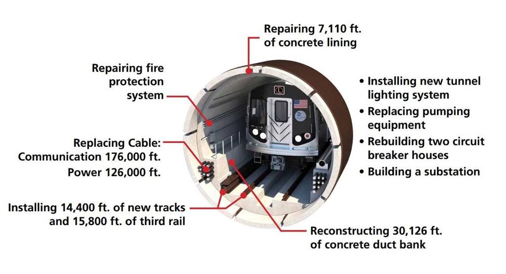
2 Reconstructing the Tunnel 2

3 Service During Tunnel Reconstruction April 2019 through July
4 Projected Cross River Travel Paths of Customers The Service Plan: Our modeling assumes 100% of trips will be accommodated by one of the following service options 4
5 Projected Cross River Travel Paths of Customers By Subway: More service 32% of customers 14% capacity increase, accommodating an additional 3,480 riders 5

6 Projected Cross River Travel Paths of Customers By Subway: More service and longer trains to/from Long Island City 28% of customers 176% capacity increase, accommodating an additional 11,100 riders More service and longer trains to/from Downtown Brooklyn 7% of customers 121% capacity increase, accommodating an additional 7,620 riders 6
7 Projected Cross River Travel Paths of Customers By Subway: From the in Queens: Additional service 11% of customers 11% capacity increase, accommodating an additional 3,480 riders Additional service 15% of customers 7% capacity increase, accommodating an additional 2,420 riders 7
8 Projected Cross River Travel Paths of Customers By Subway: in Brooklyn (longer trains) 12% will transfer from the and 7% capacity increase, accommodating 2,320 customers 8
9 Projected Cross River Travel Paths of Customers By Subway: 3% of riders will take the 9
10 Projected Cross River Travel Paths of Customers By Bus and Ferry: Four interborough Select Bus Service Routes 17% of customers 80 buses per hour, accommodating 4,200 riders New ferry service 4% of customers Eight ferries per hour, accommodating 1,190 riders 10
11 Projected Cross River Travel Paths of Customers In Summary: 79% of riders will take other subway lines 17% of riders will take interborough buses 4% of riders will take the ferry 71% of riders will have no more than 10 minutes additional travel time in AM peak 11


12 Permanent Station Improvements Prior to the tunnel closure, we are improving access to and capacity in stations along the,, and lines, that will provide alternatives to service. During the tunnel closure, we will also enhance stations along the line. 12
13 Interborough Select Bus Service 80 Buses Per AM Peak Hour will Travel Across the Williamsburg Bridge L1 SBS L2 SBS L3 SBS L4 SBS 13
14 Interborough Select Bus Service: L1 SBS Service between Grand St and 1 Ave/15 St: Every 2½ minutes during AM peak hours Every 3½ minutes during PM peak hours 14
15 Interborough Select Bus Service: L2 SBS Service between Grand St and SoHo: Every 2½ minutes during AM peak hours Every 3½ minutes during PM peak hours 15

16 Interborough Select Bus Service: L3 SBS Service between Bedford Av and SoHo: Every 2½ minutes during AM and PM peak hours 16
17 Interborough Select Bus Service: L4 SBS Service between Bedford Av and 1 Ave/15 St: Every 6 minutes during AM peak hours Every 6½ minutes during PM peak hours 17

18 Late Night Bus Service: L14 SBS 18

19 Weekend Service: L2 SBS, L3 SBS, L4 SBS

20 Bus Priority Plan 20
21 Current taxi Speed (mph) Vehicles per Hour HOV 3+ Policy: 5 AM to 10 PM, every day Buses, Trucks & HOV 3+ Only Manhattan- and Brooklyn-Bound All Lanes Key benefits 5 AM start discourages early morning congestion before regulation goes into effect HOV supports period of highest projected bus ridership demand Weekend and evening HOV hours support non-commute trips DOT coordinating with NYPD on enforcement staging, strategy Williamsburg Bridge HOV 3+ Hours Current Williamsburg Bridge Traffic Volume & Speed Traffic Volume HOV 3+ IN EFFECT HOURS Current Taxi Speed 3,000 2,500 2,000 1,500 1,
22 Interborough Buses in Williamsburg Slow or unreliable bus service would cause people to take car or taxi trip and increase traffic congestion HOV3+ restriction on the Williamsburg Bridge is expected to reduce traffic along corridor by up to 75% AM Peak (8-9am) 81 PM Peak (6-7pm) 65 Midday (3-4pm)/Nights (8-9pm) Overnight (1-5am) 6 Buses per Hour Crossing Williamsburg Bridge 25 midday/ 40 nights 22

23 L1, L2- Grand Street Transit Corridor 23

24 L1, L2- Bus Stops and Layovers 24

25 Existing Proposed Grand Street Design Features: Westbound bus lane from Bushwick Avenue to Union Avenue Parking protected bike lane Floating parking/ loading space Eastbound bus lane from Rodney Street to Keap Street Buffer protected bike lane Through traffic allowed east of Union Avenue 25


26 Grand Street Local Access Provides bus priority for buses crossing the Williamsburg Br Local access allowed to each block, must make next right turn 26
27 Grand Street Local Access Grand Street Local Access: Turn right on to Grand Street Exit at next right turn Left turns prohibited at most intersections Enforceable with bus lane cameras DOT will conduct outreach local businesses and residents about access policy Traffic analysis on the effect of bus priority on Grand Street, Metropolitan Ave, and neighborhood streets is ongoing

28 Problem Waterbury Street Curb and sidewalk parked with NYPD school safety agent cars Frequent double parking and truck traffic limits access and throughput Right turn from Bushwick Av onto Waterbury St will be tight for buses Recommendation Updated curb regulations Convert to one way southbound 28

29 L3,L4- North Williamsburg Transit Corridor 29


30 L3, L4- Bus Stop and Layovers 30


31 Williamsburg Entrance Proposal For L3 use For L1/L2 use 31


32 Bicycle Network Connections 2,000 3,500 cyclists projected to cross the Williamsburg Bridge during AM rush hour (8A-9A) 32


33 Increasing docks and bikes in the existing service area 1,250 bikes, 2,500 docks Manhattan: 59 th Street Canal Brooklyn: Williamsburg area Expanded Valet Services Staffed by Citi Bike, Valet Service allows Stations to operate at increased capacity Pedal-assist Shuttle Service 1,000 pedal assist bikes Available at key locations 2 in Manhattan 2 in Brooklyn Additional standard bike parking in key locations Citi Bike Infill

34 Weekend Preparatory Work on Line Ensure reliable service forriders during reconstruction Ensure project duration stays within 15 months No service between Manhattan and either Myrtle-Wyckoff Avs or Broadway Junction Late night service diversions are also required 34
35 Customer Service and Communications Remaining Responsive: Hundreds of MTA staff will be deployed at subway stations, bus stops and ferry locations to manage crowding to ensure safety Actively communicate with customers in real time, in person and through all available channels MTA to work with DOT and other relevant City agencies to ensure responsive information dissemination and feedback Will make adjustments to the plan in response to feedback 35

36 Proposed Alternate Subway, Bus and Ferry Services 36
Tunnel Reconstruction South 5 th Street Association October 16, 2018
 Tunnel Reconstruction South 5 th Street Association October 16, 2018 Reconstructing the Tunnel 2 Service During Tunnel Reconstruction April 2019 through July 2020 3 Projected Cross River Travel Paths of
Canarsie Tunnel Repairs: Planning Ahead for the Crisis
 Canarsie Tunnel Repairs: Planning Ahead for the Crisis Beginning in April 2019, the Canarsie Tunnel between Brooklyn and Manhattan will close for 15 months, affecting over 400,000 daily riders of the L
ITS-NY ANNUAL MEETING Bus Rapid Transit in New York City: Bus Lane Operations on One-Way Arterial Streets
 ITS-NY ANNUAL MEETING Bus Rapid Transit in New York City: Bus Lane Operations on One-Way Arterial Streets June 9, 2011 Ted Orosz AICP, Director Long Range Bus Planning MTA New York City Transit 1 Overview
M14A/D Select Bus Service
 M14A/D Select Bus Service Manhattan Community Board 6: April 1, 2019 New York City Transit 2 Background M14 Select Bus Service M14 was identified as a critical future SBS corridor in past BRT studies as
TRANSPORTATION IMPROVEMENT STRATEGY
 TRANSPORTATION IMPROVEMENT STRATEGY A Vision for Staten Island North Shore November 2016 1 EXISTING CONDITIONS Transit Conditions MTA Bus Staten Island Railroad Peak Directional Traffic Volume (per hour)**:
North Shore Transportation Improvement Strategy
 North Shore Transportation Improvement Strategy Preliminary, Near-term Recommendation 2016 April Transportation Improvement Strategy (TIS) Comprehensive and Analytical A multi-modal transportation strategy
Memorandum. Sunday, July 13, Saturday, July 19, 2014
 Memorandum To: David Lowin, Brooklyn Bridge Park Corporation From: Daniel Schack, AICP, PTP Date: Re: Brooklyn Bridge Park Pier 5/6 Loop Road Traffic Study Project No: 14-01-2407 At the request of Brooklyn
Strategies to keep people and goods moving in and through Seattle
 Strategies to keep people and goods moving in and through Seattle The Seattle Squeeze and the #Realign99 Closure 2018-2024 Commute Seattle Employer Department Open of Transportation House December 7, 2018
Outreach Approach RENEW SF served as the primary liaison with the North Beach community; the Chinatown. Executive Summary
 Executive Summary Executive Summary The Columbus Avenue Neighborhood Transportation Study s objective is to identify changes to transportation infrastructure and policies that could enhance the livability
Eliminate on-street parking where it will allow for a dedicated bus only lane %
 Traffic Dashboard Priorities Survey Responses Introduction 1) Are you familiar with bus rapid transit (BRT)? a. No, BRT is new to me. 597 23.5% b. I ve heard of BRT, but I don t know much about it. 1,136
43 rd Avenue, Skillman Avenue Protected Bike Lanes
 43 rd Avenue, Skillman Avenue Protected Bike Lanes Presented to Queens Community Board 2 Transportation Committee - November 6, 2017 43 rd Avenue, Skillman Avenue: Presentation Overview Background Project
2014/2015 BIKE ROUTE PLAN 83 AVENUE PROTECTED BIKE LANE
 About the Project 2014/2015 BIKE ROUTE PLAN The City of Edmonton is planning a major bike route on the south side of Edmonton. This bike route is one part of a plan to provide citizens with transportation
2014/2015 BIKE ROUTE PLAN 83 AVENUE PROTECTED BIKE LANE
 About the Project The City of Edmonton is planning a major bike route on the southside of Edmonton. The Strathcona Bike Route will connect the communities of Strathcona, Garneau and the University area,
Bellevue Downtown Association Downtown Bike Series
 Bellevue Downtown Association Downtown Bike Series Meeting 2 Franz Loewenherz Andreas Piller Kyle Potuzak Chris Long October 26, 2017 Today s Agenda: 1) Meeting Purpose 2) 9/28 Meeting Recap 3) Candidate
WELCOME! Please complete a comment sheet as we value your feedback. 4 pm to 8 pm. September 15, Hosted by: AECOM on behalf of City of Calgary
 WELCOME! Thank you for attending our open house. There will be no formal presentation today so please take the time to read the boards. If you have any questions, please do not hesitate to approach one
Washington DC Section of ITE Project Briefing
 Washington DC Section of ITE Project Briefing November 5, 2015 Renée Hamilton, VDOT, Deputy District Administrator I-66 Outside the Beltway Improvement Area Project Location Virginia 2 Purpose and Need
Existing Transportation System
 < Open for Additional Text Transportation System Existing Transportation System This section describes vehicular transportation associated with Children s. transportation are described in a separate section
122 Avenue: 107 Street to Fort Road
 : 107 Street to Fort Road November 24, 2015 4:30 8:00 p.m. Meeting Purpose Summarize project work completed to date Share results of public input from Phase 1 Share the draft concept plan and proposed
Scarlett Road Bridge & Road Improvements Lambton Park Community School - Gymnasium Tuesday November 28 th, 2017
 Scarlett Road Bridge & Road Improvements Lambton Park Community School - Gymnasium Tuesday November 28 th, 2017 PROJECT LOCATION 2 SCARLETT ROAD BRIDGE Constructed in 1912, the bridge carries 4 active
Queensboro Bridge Bus Priority Study: Summary of Recommendations. Presentation to Manhattan Community Board 8 May 4, 2011
 : Summary of Recommendations Presentation to Manhattan Community Board 8 May 4, 2011 1 Overview Study Goal: Identify cost-effective ways to improve bus speed and reliability for local and express buses
Benefits for the Bronx, Brooklyn, Queens and Staten Island
 Congestion Pricing for New York: Benefits for the Bronx, Brooklyn, and Staten Island Prepared for the Coalition for Traffic Relief April 007 Schaller Consulting 94 Windsor Place, Brooklyn, NY (78) 768-3487
Designing Streets for Transit. Presentation to NACTO Designing Cities Kevin O Malley Managing Deputy Commissioner 10/24/2014
 Designing Streets for Transit Presentation to NACTO Designing Cities Kevin O Malley Managing Deputy Commissioner 10/24/2014 Chicago -- Streets for Transit TODAY Jeffery Jump Transit Signal Priority Central
Reference number /VP. Lafayette Downtown Congestion Study - Additional Traffic Analysis
 To James Hinkamp and Tony Coe, City of Lafayette Date January 19, 2017 Copies Reference number 243381/VP From Michael Iswalt and Vanessa Peers File reference 4-05 Subject Lafayette Downtown Congestion
Appendix C. NORTH METRO STATION AREA TRAFFIC IMPACT STATEMENT 88th Avenue Station
 Appendix C NORTH METRO STATION AREA TRAFFIC IMPACT STATEMENT 88th Avenue Station Prepared for: Regional Transportation Department and URS Corporation as part of the North Metro EIS David Evans and Associates,
University Avenue & Farley Avenue/University Bay Drive Area Scenario Base Conditions Multiple concerns
 ped at signalized East of U-Bay North of Campus on Farley Ave./ U-Bay & Westbound Campus North of on Farley Ave./ U-Bay Near VA on MB1: Dual Eastbound Left-Turn Lanes Generally compatible with BRT and
Toronto and East York Community Council. Director, Transportation Services, Toronto and East York District
 No Turn on Red Regulations STAFF REPORT ACTION REQUIRED Date: June 1, 2010 To: From: Toronto and East York Community Council Director, Transportation Services, Toronto and East York District Wards: Trinity
FOLSOM-HOWARD STREETSCAPE OVERVIEW
 FOLSOM-HOWARD STREETSCAPE OVERVIEW SoMa residents should have the same kinds of amenities that other neighborhoods have. The Folsom- Howard Streetscape Project will make SoMa more livable by making it
BETHEL ROAD AND SEDGWICK ROAD CORRIDOR STUDY
 DRAFT PLAN City Council Meeting August 14, 2017 STUDY AREA Sedgwick Corridor State Route 160, principal arterial with Class 3 access management designation, commuter and freight route, connection to SR
COMMUNITY MEETING AGENDA
 COMMUNITY MEETING AGENDA Welcome and Introductions SAFE Presentation Project Presentation Priorities Feedback Next Steps Q&A Santa Cruz Avenue Corridor Study 1 Santa Cruz Avenue Corridor Study Community
Major Bike Routes 102 Avenue Workshop April 21, 2015
 Major Bike Routes 102 Avenue Workshop April 21, 2015 Our Purpose Today Provide context on how Major Bike Routes fit into Edmonton s future Share information on what we heard in our last phase, and how
TRANSPORT CHICAGO: STRATEGIC PUBLIC TRANSIT BUS RELIABILITY IMPROVEMENTS
 TRANSPORT CHICAGO: STRATEGIC PUBLIC TRANSIT BUS RELIABILITY IMPROVEMENTS Presented by David VanderZee and Jack Chalabian Monday, June 02, 2014 Overview of Strategic Route Management CTA Strategic Route
25th Avenue Road Diet Project A One Year Evaluation. Transportation Fund for Clean Air Project #05R07
 25th Avenue Road Diet Project A One Year Evaluation Transportation Fund for Clean Air Project #05R07 Submitted by: The San Francisco Municipal Transportation Agency Dan Provence May 22, 2009 EXECUTIVE
Los Altos Hills Town Council - June 18, 2015 Palo Alto City Council June 22, AGENDA ITEM #2.B Presentation
 Los Altos Hills Town Council - June 18, 2015 Palo Alto City Council June 22, 2015 AGENDA ITEM #2.B Presentation Previous Presentations Los Altos Hills Town Council in May 2014 and February 2015 Palo Alto
Southside Pilot Proposal
 To improve bicycle access and mobility to UC Berkeley, Downtown Berkeley, and the Southside area, a pilot project could include a two-way parking-protected cycle track. Turn pockets and island bus stops
Metropolitan Council Transportation Committee
 Nicollet-Central Transit Alternatives Metropolitan Council Transportation Committee August 2013 Project Purpose (approved by Policy Advisory Committee 10/25/2012) The purpose is to improve transit connectivity,
Welcome. If you have any questions or comments on the project, please contact:
 Welcome This drop-in public open house is intended to provide information about the Bay Street bike lanes project. This project proposes a dedicated cycling facility along Bay Street between Aberdeen Avenue
Bicycle Master Plan Goals, Strategies, and Policies
 Bicycle Master Plan Goals, Strategies, and Policies Mobilizing 5 This chapter outlines the overarching goals, action statements, and action items Long Beach will take in order to achieve its vision of
Mission Bay Loop (MBL) Public Meeting
 Public Meeting") Mission Bay Loop (MBL) Public Meeting La Scuola Internazionale di San Francisco, November 18, 2014 Frequently Asked Questions 1. When would construction have to start before the SFMTA loses TIGER funds?
Mission Bay Loop (MBL) Public Meeting La Scuola Internazionale di San Francisco, November 18, 2014 Frequently Asked Questions 1. When would construction have to start before the SFMTA loses TIGER funds?
In station areas, new pedestrian links can increase network connectivity and provide direct access to stations.
 The Last Mile Planning for Pedestrians Planning around stations will put pedestrians first. Making walking to stations safe and easy is important; walking will be a part of every rapid transit Accessible
Seattle Department of Transportation (SDOT) Preliminary Responses to Madison-Miller Community List of Site-Specific Concerns
 Preliminary Responses to Madison-Miller Community List of Site-Specific Concerns") Seattle Department of Transportation (SDOT) Preliminary Responses to Madison-Miller Community List of Site-Specific Concerns Background In July 2002 SDOT staff met with a small group of community residents
Seattle Department of Transportation (SDOT) Preliminary Responses to Madison-Miller Community List of Site-Specific Concerns Background In July 2002 SDOT staff met with a small group of community residents
Sacramento Grid 2.0. The Downtown Transportation Study
 Sacramento Grid 2.0 The Downtown Transportation Study April 20, 2016 The Grid 4.25 square miles Street grid defined at birth of City Lettered and numbered streets spaced every 400 ft East-west alleys halfway
City of Davis East Covell Corridor Plan
 Community Open House #2 January 22, 2014 6:00 8:00 p.m. Veterans Memorial Center, Club Room City of Davis Introduction The (ECCP) is a taking a comprehensive look at the existing transportation systems
Aaron s European Transportation Vacation Slide Show
 New York Metropolitan Transportation Council Brown Bag Lunch Speakers Series Aaron s European Transportation Vacation Slide Show Presentation by Aaron Naparstek Wednesday, November 16, 2005. Permission
Transportation and Equity: A 2017 Agenda for Candidates
 In New York, mobility is opportunity. We have succeeded as a global leader in social justice, economic growth and environmental sustainability by investing for more than a century in comprehensive, reliable
NEWS RELEASE Embargoed for Release: More Info: Gene Russianoff (917) Tuesday, December 7, 2010, 10:30 a.m. Paul Steely White (646)
 Tuesday, December 7, 2010, 10:30 a.m. Paul Steely White (646)") NYPIRG STRAPHANGERS CAMPAIGN TRANSPORTATION ALTERNATIVES NEWS RELEASE Embargoed for Release: More Info: Gene Russianoff (917) 575-9434 Tuesday, December 7, 2010, 10:30 a.m. Paul Steely White (646) 247-6734
NYPIRG STRAPHANGERS CAMPAIGN TRANSPORTATION ALTERNATIVES NEWS RELEASE Embargoed for Release: More Info: Gene Russianoff (917) 575-9434 Tuesday, December 7, 2010, 10:30 a.m. Paul Steely White (646) 247-6734
Cherry Creek Transportation and Land Use Forum September 25, 2013 Meeting Summary
 Cherry Creek Transportation and Land Use Forum September 25, 2013 Meeting Summary I. LEAD-IN TO SMALL GROUP DISCUSSION, POLLING AND STEERING COMMITTEE/TECHNICAL TASK FORCE DISCUSSION The meeting began
Bay to Bay Boulevard Complete Streets Project
 Bay to Bay Boulevard Complete Streets Project Dale Mabry Highway to Bayshore Boulevard February 08, 2018 Photo Source: Tampa Bay Times Alessandra Da Pra Meeting Format Introduction Resurfacing Information
Thank you for attending
 Improving mobility safety comfort WELCOME Thank you for attending The purpose of this meeting is to: Learn about the project Prioritize potential walking and biking improvements on Snelling Ave Gather
Solana Beach Comprehensive Active Transportation Strategy (CATS)
") Solana Beach Comprehensive Active Transportation Strategy (CATS) 3.0 Goals & Policies The Solana Beach CATS goals and objectives outlined below were largely drawn from the Solana Beach Circulation Element
Solana Beach Comprehensive Active Transportation Strategy (CATS) 3.0 Goals & Policies The Solana Beach CATS goals and objectives outlined below were largely drawn from the Solana Beach Circulation Element
Presentation to Media. February 27, 2008
 Anacostia Waterfront Nationals Ballpark Transportation Management Plan Presentation to Media February 27, 2008 Overarching Goals of DDOT s Ballpark TMP Organize and manage traffic to ensure pedestrian
395 Express Lanes Extension
 395 Express Lanes Extension January 2016 Building a network of Express Lanes Project overview Add capacity on I-395 with addition of a third HOV lane and active traffic management Generate guaranteed transit
Public Information and Participation Comments
 Two public meetings were held in December. The first meeting was December 6, 2011 at Mary Ellen Henderson Middle School and had 36 public attendees. The second meeting was on December 14, 2011 at the Arlington
WELCOME Mission-Geneva Transportation Study
 WELCOME Mission-Geneva Transportation Study Study Process and Schedule 2005 2006 Oct Nov Dec Jan Feb Mar Apr May Jun Jul Aug Sept Oct Task 2 Develop Outreach Plan Task 3 Document Existing Conditions/ Prioritize
2013 Candidate Questionnaire
 2013 Candidate Questionnaire OVERVIEW For New York City to compete in the global economy and provide the safety and quality of life New Yorkers deserve, our leaders must embrace a 21st Century vision for
From Disarray to Complete Street:
 From Disarray to Complete Street: Utilizing BRT to improve bus service, pedestrian safety, and traffic organization in the South Bronx BRT, TOD and Complete Streets TRB BRT Conference June 19, 2018 We
Bikeway action plan. Bicycle Friendly Community Workshop March 5, 2007 Rochester, MN
 Bikeway action plan Summary The was held on March 5, 2007 at the Rochester Mayo Civic Center. The workshop was hosted by Rochester-Olmsted County Planning Department in collaboration with the League of
Crystal City Potomac Yard Transitway. Enforcement Ordinance & Construction Update
 Enforcement Ordinance & Construction Update December 2015 Project Purpose Provide high-capacity, high-quality transit service Support redevelopment in Crystal City and in Potomac Yard in Alexandria and
» Draft Recommendations» Discussion» Next Steps. Plan for Walking and Biking
 SAC Meeting Plan #3 for September Walking and 12, Biking 2018 » Draft Recommendations» Discussion» Next Steps Plan for Walking and Biking » Stakeholder and Public Outreach» Background data collection and
North Coast Corridor:
 North Coast Corridor: Connecting People, Transportation & Environment Legislative Hearing: 11.8.10 1 North Coast Corridor Region s Lifeline A Regional Strategy Mobility, Economy & Environment North Coast
C C C
 C-012-001 Thank you for your support for the creation of new public space and nonmotorized access between downtown and the waterfront through the Overlook Walk, the East-West Connections, and the Promenade.
DULLES AREA TRANSPORTATION ASSOCIATION (DATA) February 18, Susan Shaw, P.E., VDOT, Megaprojects Director
 February 18, Susan Shaw, P.E., VDOT, Megaprojects Director") DULLES AREA TRANSPORTATION ASSOCIATION (DATA) February 18, 2015 Susan Shaw, P.E., VDOT, Megaprojects Director I-66 Corridor Conditions Steady population growth Employment growth in activity centers Congestion
DULLES AREA TRANSPORTATION ASSOCIATION (DATA) February 18, 2015 Susan Shaw, P.E., VDOT, Megaprojects Director I-66 Corridor Conditions Steady population growth Employment growth in activity centers Congestion
41st Avenue B-Line Kerrisdale Village Street Improvements
 1. WELCOME! 41st Avenue B-Line Kerrisdale Village Improvements Public Open House Please sign in so we can provide updates and information on construction The City of Vancouver is working with TransLink
ECONOMY PEOPLE ENVIRONMENT
 Report Back on Local Transit Improvements May 29, 2013 ECONOMY PEOPLE ENVIRONMENT Intro Council Requested Report Back Topics Progress on Planning for Broadway Subway False Creek Bridges Local Transit Improvements
Welcome to the Sellwood Bridge Project Open House!
 Welcome to the Sellwood Bridge Project Open House! 5:30 7:30 pm Please sign in here Information stations and project staff are located throughout the room. Goals for Tonight s Meeting: Learn how the Preferred
CITY OF OTTAWA ROADWAY MODIFICATION APPROVAL UNDER DELEGATED AUTHORITY
 RMA-2015-ATM-038 CITY OF OTTAWA ROADWAY MODIFICATION APPROVAL UNDER DELEGATED AUTHORITY DATE: April 22, 2015 SUBJECT Approval of Roadway Modifications Recommended through an Area Traffic Management Study
Summary of Comments Public Meeting: Marietta Street Resurfacing Project Atlanta Contemporary August 29, 2017 / 6:00 pm to 8:00 pm
 Renew Atlanta hosted a public meeting to discuss the Marietta Street Resurfacing project at. Councilmember Cleta Winslow attended the public meeting, where over seventy (70) citizens to include representatives
Purpose and Need. Chapter Introduction. 2.2 Project Purpose and Need Project Purpose Project Need
 Chapter 2 Purpose and Need 2.1 Introduction The El Camino Real Bus Rapid Transit (BRT) Project (Project) would make transit and other transportation improvements along a 17.6-mile segment of the El Camino
Richmond-Adelaide Cycle Tracks
 Public Drop-In Event Richmond-Adelaide Cycle Tracks June 25, 2018 12:00 p.m. 3:00 p.m. 4:30 p.m. 7:30 p.m. Metro Hall, Rotunda 55 John Street 1 Purpose of Event In Scope Communicate an update about the
GEARY CORRIDOR BUS RAPID TRANSIT Environmental Analysis. Special Intersections: Preliminary Concepts
 GEARY CORRIDOR BUS RAPID TRANSIT Environmental Analysis Special Intersections: Preliminary Concepts April 2, 2009 FILLMORE: Existing Conditions 3 lanes in underpass, 2 lanes in service road (each direction)
Chapter 7. Transportation. Transportation Road Network Plan Transit Cyclists Pedestrians Multi-Use and Equestrian Trails
 Chapter 7 Transportation Transportation Road Network Plan Transit Cyclists Pedestrians Multi-Use and Equestrian Trails 7.1 TRANSPORTATION BACKGROUND The District of Maple Ridge faces a number of unique
CAMBRIDGE SOUTH WEST PARK & RIDE
 CAMBRIDGE SOUTH WEST PARK & RIDE Have your say on: Extra Park & Ride spaces to the south west of Cambridge Bus priority measures into the city centre CREATING MORE PARK & RIDE SPACES The existing Park
4. ENVIRONMENTAL IMPACT ANALYSIS 9. TRANSPORTATION AND TRAFFIC
 4. ENVIRONMENTAL IMPACT ANALYSIS 9. TRANSPORTATION AND TRAFFIC 4.9.1 INTRODUCTION The following section addresses the Proposed Project s impact on transportation and traffic based on the Traffic Study
Arlington Public Schools Thomas Jefferson Site Evaluation Transportation Networks. Thomas Jefferson Working Group Meeting #6 November 10, 2014
 Arlington Public Schools Thomas Jefferson Site Evaluation Transportation Networks Thomas Jefferson Working Group Meeting #6 November 10, 2014 2 3 INTRODUCTION 4 Goal of our work: Identify and assess multi-modal
Afeasibility study to evaluate bus rapid transit service in the East-West Corridor connecting major employment and activity centers between downtown
 East-West Bus Rapid Transit Feasibility Study Update and Recommended Locally Preferred Alternative (LPA) Summary City of Wauwatosa, Transportation Affairs Committee June 2016 Afeasibility study to evaluate
ABOUT THIS STUDY The Tenderloin-Little Saigon Community-Based Transportation Plan
 ABOUT THIS STUDY The Tenderloin-Little Saigon Community-Based Transportation Plan The Greater Tenderloin Community Study Milestones October Community based organizations (Tenderloin Housing Clinic and
City of Fairfax, Virginia City Council Work Session
 City of Fairfax, Virginia City Council Work Session Agenda Item # 4c City Council Meeting 6/2/2015 TO: FROM: SUBJECT: Honorable Mayor and Members of City Council Robert Sisson, City Manager Discussion
US 278 Corridor Concept Presentation. Avondale Estates Intersection Improvement/Roundabout and Road Diet Feasibility Study March 19, 2015
 US 278 Corridor Concept Presentation Avondale Estates Intersection Improvement/Roundabout and Road Diet Feasibility Study March 19, 2015 Thanks to our Partners Atlanta Regional Commission Georgia Department
WELCOME! We want to hear from you! CAMBIE BRIDGE INTERIM IMPROVEMENTS KEY OBJECTIVES:
 WELCOME! CAMBIE BRIDGE ITERIM IMPROVEMETS The City of Vancouver is planning to make interim improvements to Cambie Bridge to make it safer and more comfortable for people of all ages and abilities to walk
HIGHBURY AVENUE/HAMILTON ROAD INTERSECTION IMPROVEMENTS PUBLIC INFORMATION CENTRE 1 MAY 14, 2015
 HIGHBURY AVENUE/HAMILTON ROAD INTERSECTION IMPROVEMENTS Municipal Class Environmental Assessment PUBLIC INFORMATION CENTRE 1 MAY 14, 2015 ACCESSIBILITY Under the Accessibility Standards 2015 for Customer
Welcome! San Jose Avenue Open House August 25, 2015
 Welcome! San Jose Avenue Open House August 25, 2015 Vision Zero The City and County of San Francisco adopted Vision Zero San Francisco Vision Zero High Injury Network as a policy in 2014, committing an
Public Works and Infrastructure Committee. General Manager, Transportation Services
 STAFF REPORT ACTION REQUIRED Extending the Bay Street Bicycle Lanes Date: May 16, 2013 To: From: Public Works and Infrastructure Committee General Manager, Transportation Services Wards: Toronto Centre
1. Provide a dedicated westbound approach bus lane at the intersection;
 3. MODIFICATIONS AT HIGHWAY 417 WESTBOUND OFF-RAMP/PINCREST ROAD - PUBLIC HEARING COMMITTEE RECOMMENDATIONS Having held a public hearing, that Council approve the preliminary design for the proposed modifications
+selectbusservice. M15 on First and Second Avenues: Progress Report
 +selectbusservice M15 on First and Second Avenues: Progress Report Existing 2 Condition Executive Summary The M15 bus route along First Avenue and Second Avenue provides a critical transportation service
Welcome. Welcome to the second open house on the Downtown Transportation Study.
 Welcome 1 Welcome to the second open house on the Downtown Transportation Study. The purpose of this meeting is to: Recap the study objectives Summarize feedback to date Present information on the alternatives
M Street SW-Southeast Federal Center
 Section 1 M Street SW-Southeast Federal Center 1 2 M Street SW M Street SW and the Southeast Federal Center, located in Southeast and Southwest Washington, DC, comprise an activity center area that is
Scope of the Transit Priority Project
 Transit Planning Committee #1 March 19, 2015 Scope of the Transit Priority Project Review of the 2010 plan Analysis of Transit Priority Measures Preliminary plans for rapid transit Recommendations for
Key objectives of the survey were to gain a better understanding of:
 3 COMMUNITY INPUT Community input is an essential part of corridor studies. For the SR 87 corridor study, VTA staff conducted an extensive online survey of people living and commuting along the corridor.
to the Public Information Centre for the Downtown Traffic Study
 to the Public Information Centre for the Downtown Traffic Study City of Sault Ste. Marie July 25, 2018 Purpose of Study Determine if changes to one-way corridors can enhance downtown s character and spaces
Water Street Corridor Streetscape TRAFFIC STUDY
 TRAFFIC STUDY November 12, 2015 WATER STREET CORRIDOR STREETSCAPE IMPROVEMENTS PROJECT BOROUGH OF MANHATTAN EDC Contract No.: 48480002 Prepared for: Prepared by: TABLE OF CONTENTS I. INTRODUCTION/ EXECUTIVE
About the Wilmington Downtown Circulation Study
 About the Wilmington Downtown Circulation Study Part of the Wilmington i Initiatives partnership Wilmington Area Planning Council City of Wilmington Delaware Department of Transportation Delaware Transit
NACTO Designing Cities 2014 Dongho Chang, City Traffic Engineer October 23, 2014
 NACTO Designing Cities 2014 Dongho Chang, City Traffic Engineer October 23, 2014 Presentation overview Perspective on Safety Changing needs of our cities How Seattle is meeting those needs Challenge for
Cycling Facilities on Woodbine Avenue and Corley Avenue
 PW15.10 REPORT FOR ACTION Cycling Facilities on and Corley Date: September 13, 2016 To: Public Works and Infrastructure Committee From: Acting General Manager, Transportation Services Wards: Ward 31 -
Transportation Assessment
 Transportation Assessment Midtown Open House February 10, 2018 Overview Midtown in Focus Overview & Purpose of Today Transportation Assessment overview Summary of Transportation work to date Review & Analysis
Draft North Industrial Area-Wide Traffic Plan
 Summary of North Industrial and Hudson Bay Industrial Recommended Improvements Table 1. Summary of s Item Location 1 2 3 4 5 6 7 8 9 10 11 12 Millar Ave north of 51st St Super 8 Motel back lane 400 Block
NEW YORK, NEW YORK BUS LANES AND LIMITED-STOP SERVICE
 NEW YORK, NEW YORK BUS LANES AND LIMITED-STOP SERVICE Table of Contents NEW YORK CITY, NEW YORK (USA)... 1 SUMMARY... 1 CITY CONTEXT... 1 PLANNING AND IMPLEMENTATION BACKGROUND... 1 BUS PRIORITY TREATMENTS...
5. RUNNINGWAY GUIDELINES
 5. RUNNINGWAY GUIDELINES These guidelines should be considered collectively when making runningway decisions. A runningway is the linear component of the transit system that forms the right-of-way reserved
City of Beverly Hills North Santa Monica Blvd Reconstruction. Community Meeting Presentation September 30 and October 1, 2015
 City of Beverly Hills North Santa Monica Blvd Reconstruction Community Meeting Presentation September 30 and October 1, 2015 1 Project Description Complete reconstruction of boulevard (pavement, curbs,
Station Plan: Penn & 43rd Avenue
 Station Plan: Penn & 43rd Avenue This station will serve the northern portion of the Penn Avenue corridor, including the commercial node at 44th Avenue. Ridership and roadway geometry support station siting
Brown Line Capacity Expansion Project Supplemental Service Strategy for Construction-Related Three-Track Operation
 Brown Line Capacity Expansion Project Supplemental Service Strategy for Construction-Related Three-Track Operation February 14, 2007 Description of the Brown Line Reconstruction Project and Customer Impact
Transportation, Parking & Roads
 Transportation, Parking & Roads Design Carolina North as a walkable community Design the transportation system and development patterns (i.e., urban design elements such as density, building design, mix