STATE TRANSPORTATION COMMISSION HEARING
|
|
|
- Augustus Dennis
- 5 years ago
- Views:
Transcription


1 STATE TRANSPORTATION COMMISSION HEARING Twelve Year Program Update Tom Zilla: Centre County MPO Jim Saylor: SEDA-COG RPO Amy Kessler: North Central RPO PennDOT District 2-0 State College, PA October 8, 2009

")
2 Regional Map Sq. Mi 9,617 (21.4% of state) Pop -732,000 (6% of state) 76.1 people per sq mi.
 1,003 local bridges (>20")

 913 miles of rail 569")
3 Regional Information State of the Region (15 counties) 3,743 state bridges (>20 feet) 1,003 local bridges (>20 feet) 3 major interstates 427 Miles 653 miles of NHS highways 315 traffic signals 4 fixed route transit operators (ATA, CATA,DUFAST and LATS) 22 airports (General aviation and commercial) 913 miles of rail 569 grade crossings


4 Progress from 2007 to bridge improvements bid since 7/1/ miles of existing pavement were resurfaced Major projects I-99 Mainline 219 Johnsonburg Bypass 219 Bradford Bypass 322 Lewistown Narrows 220 Lock Haven Bypass I-80 Reconstruction 61 Cameron Bridge - Shamokin Lewistown Narrows Interstate 99 Johnsonburg Bypass

5 Our Focus Maintaining system especially core highways Bridges IRI and pavement cycles Safety Multi-Modal Investments Fully utilizing our resources Bridge preservation Act 44 Bond financing ARRA
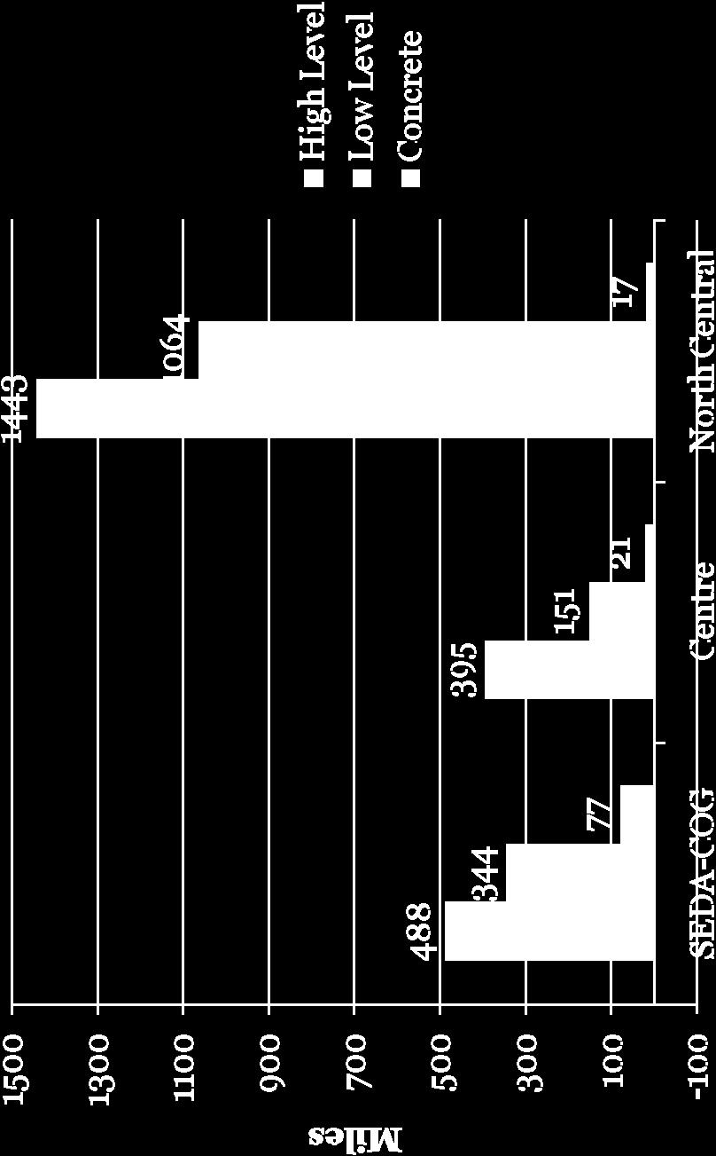
6 Age of State Bridges Number of Bridges SEDA-COG North Central Centre % SD Deck Area 31.4 % of Bridges are SD Number of Years 701 of 2231


7 Bridge SD Deck Percentages State Bridges Percentage % SD 2007 % SD

8 SD Bridges by System
9 Bridge Condition Weight Restricted or Closed Bridges State Weight Restricted or Closed Bridges 120 Local Weight Restricted or Closed Bridges SEDA Cog Centre North Central 0 SEDA Cog Centre North Central


10 Unprogrammed Bridge Needs Beyond 2010 Millions of Dollars SEDA COG Centre North Central Total Needs Program Balance * * Amount needed to complete project phases already started on 09 TIP


11 Pavement Networks (Non-Interstate)

12 Pavement Smoothness Percent of Poor IRI miles
13 IRI by Functional Class (Core Network Improving) IRI on the secondary network is lagging behind
14 Roadway Resurfacing Needs (Non-Interstate) Annual Miles Required to Meet Cycle SEDA COG Centre NorthCentral 2009 Roadway Gap
15 Pavement Networks out of Cycle As of Non Interstate Roadways 605 Miles SEDA COG Centre North Central Out of cycle not programmed Programmed In cycle

16 Pavement Networks out of Cycle As of 2010 Miles Interstate Roadways SEDA COG Centre North Central Out of cycle not programmed Programmed In cycle


17 What are we doing about Safety Our Process: Crash cluster list reviewed and discussed with Planning Partners Conduct field views Identify projects Prepare cost estimates Prioritize project list Secure funding Use measures to analyze effectiveness of project
18 Transit Fixed Route Operators Fixed Route Operator Centre Area Transportation Authority (CATA) Lower Anthracite Transportation System (LATS) [Mt. Carmel] Area Transportation Authority (ATA) [North Central] DuBois, Falls Creek, Sandy Township Joint Transportation Authority (DuFAST) Service Area (Sq. Mi.) Population of Area , ,000 5, , ,378
19 Transit Fleet Statistics SEDA-COG Fixed Route Avg. Fleet Age (years) Paratransit Avg. Fleet Age (years) LATS (Mt. Carmel) Mifflin/Juniata Co Montour Co MTR/Columbia Co Northumberland Co STEP (Lycoming/Clinton) Union-Snyder Co TOTAL
20 Transit Fleet Statistics Centre County Fixed Route Avg. Fleet Age (years) Paratransit Avg. Fleet Age (years) CATA CCOT TOTAL
21 Transit Fleet Statistics North Central Fixed Route Avg. Fleet Age (years) Paratransit Avg. Fleet Age (years) ATA (in fixed route total) - DuFAST TOTAL
22 Transit Ridership Trends SEDA-COG Ridership Trends LATS (Mt. Carmel) 51,000 Mifflin & Juniata Co. 58,000 Montour Co. 23,000 MTR/Columbia Co. 37,000 Northumberland Co. 140,000 STEP (Lycoming/Clinton) 145,000 Union-Snyder 78,000 TOTAL 532,000
23 Transit Ridership Trends Centre County Ridership Trends CATA 6,557,000 Centre Co. 80,000 TOTAL 6,637,000
24 Transit Ridership Trends North Central Ridership Trends ATA 647,000 DuFAST 62,000 TOTAL 709,000
25 Transit Productivity Fixed Route Operator Ridership per Revenue Hour CATA 60.7 LATS (Mt. Carmel) 11.1 ATA (North Central) 3.4 (Includes paratransit) DuFAST 6.6
26 Transit Productivity Paratransit Operators Paratransit Ridership per Paid Driver Hour Mifflin/Juniata Co. 2.9 Montour Co. 3.1 MTR/Columbia Co. 1.9 Northumberland Co. 1.6 STEP (Lycoming/Clinton) 2.4 Union-Snyder Co. 1.6 CATA 2.9 CCOT 2.5
27 Funding Allocations ($ M) FFY 2009 Planning Region North Central Bridge Roadway Safety Act 44 Bond ARRA Maint $ 30.7 $ 17.6 $ 2.7 $ 11.9 $ 7.7 $ 26.7 $ 10.1 Centre $ 3.4 $ 6.7 $ 2.0 $ 3.9 $ 0.9 $ 7.9 $ 1.5 SEDA-COG $ 24.6 $ 22.4 $2.5 $ 12.9 $ 4.1 $ 13.7 $ 3.9 FFY 2010 Planning Region North Central Bridge Roadway Safety Act 44 Bond Maint $ 31.6 $ 18.1 $ 2.8 $ 11.9 $ 8.1 $ 6.5 Centre $ 3.5 $ 6.8 $ 2.1 $ 3.9 $ 0.1 $ 2.7 SEDA-COG $ 25.2 $ 23.0 $ 2.6 $ 12.9 $ 3.7 $ 1.5
28 Funding Gaps More bridge needs than available funding Each planning partner has over a 25 year backlog of needs versus available funding A decrease in Act 44 funding and a reduced maintenance allocation will reduce our ability to maintain excellent IRI on our core system Local Bridge Needs far outpace available funding Local bridges < 20 feet in length funding need unknown currently no statewide inventory
29 Comparing the Known Gaps Known SD Bridges Highways $ Millions Required Funding Level $ 91 M ARRA TIP Act 44 Bond $ Millions Required Funding Level $ 81.2 M ARRA TIP Act 44 Maint. Year Year
30 Act 44 Funding Millions of Dollars Present Level After 7/1/10 60% reduction 0 SEDA COG Centre North Central
31 Efforts to Close the Gaps Bridges Set aside TIP Line Item for bridge preservation Use of Bridge Risk Assessment Tool proper treatment at proper time i.e. bridge painting Bridge Priority 1 s contract to take care of the immediate needs Participating in Local Bridge Task Force Bond funding ARRA funding
32 Efforts to Close the Gaps Highways Balancing Act 44 funding between highway and bridge ARRA funding Pavement Treatment Task Force More seal coat treatments Pavement recycling Warm mix asphalt


33 North Central RPO Development of a Project Prioritization Process Linking Land Use, Transportation & Economic Development Identifies Projects of Regional Significance Optimizes allocation of finite resources Improves front end ROI justification for investments Incorporates all project types: transportation, economic development, recreation and others Strengthens accountability to Board, Stakeholders, Public


34 North Central RPO First of its Kind Synthesis of: North Central Strategic Plan Long Range Transportation Plan (LRTP) Comprehensive Economic Development Strategy (CEDS) County Comprehensive Plans Tourism/Marketing Plans Keystone Principles Other Planning documents Public County & Local Gov t North Central State Gov t Employers Federal Gov t
35 North Central RPO Overall Project Prioritization Process Defined criteria Highway Restoration Highway/New Capacity State & Local Bridges Safety Operations Transportation Enhancements Performance Measures Integrated Decision-making

36 North Central RPO What is the Regional Core System? It considers the Big Picture of the region. It is a tool to help improve the flow of people and goods among our counties and even beyond our region s borders It considers vital links at a regional level It considers all modes and the connections between those modes It follows guidance from the PA Mobility Plan It will be used as a criterion in evaluating competing priorities It indicates where as a region we wish to target integrated investments (e.g., road, water, sewer, etc.) as well as areas we want to preserve

37 North Central RPO Web-Based Project Submission Site is currently under construction Will be used to capture project requests for later evaluation/scoring
38 SEDA-COG RPO Project Selection Process Project prioritization process developed in 2005 Successfully adapted the process to apply it to new programs Revising the process as part of our ongoing LRTP update


39 SEDA-COG RPO Land Use, Transportation and Economic Development Funding projects by SEDA-COG JRA to make alternative modes a reality Newberry Rail Yard in Williamsport White Rock Quarry Rail Spur, Yard & Bulk Transfer First Quality Baby Products, Lewistown


40 SEDA-COG RPO Educating Land Use Decision Makers Sponsoring local training through LTAP and other programs Traffic Calming Stormwater Management Transportation Impact Fees Posting and Bonding Access Management Bicycle/Pedestrian Planning and Design


41 SEDA-COG RPO Planning for Better Connections CSVT Interchange Study Susquehanna Greenway Strategic Action Plan NCPPTT Needs Assessment Valley Vision 2020

42 Centre County MPO LRTP Project Evaluation Process Used for current LRTP Revised for new LRTP Multiple Steps Project solicitation Project ranking criteria Policy review and adjustments

43 Centre County MPO LRTP Project Evaluation Process Ranking criteria based on CCMPO s goals for LRTP Federal planning factors PA Mobility Plan goals New scoring system Likert system Weighted scores Projects must have municipal support

44 Centre County MPO Project Ranking Criteria Top three of nine 1. Safety and Security 2. Preservation of the Existing Transportation System 3. Efficient System Management and Operation

45 Centre County MPO Project Ranking Criteria 6. Consistency with Planned Growth and Development Areas Comprehensive Plans
46 Centre County MPO Project Ranking Criteria 6. Consistency with Planned Growth and Development Areas Zoning Ordinances


47 Centre County MPO Land Use/Transportation Elements Regional Growth Boundary Sewer/Water Service Boundary

48 Centre County MPO Land Use/Transportation Elements Corridor Overlay Zones I-99 Interchange Overlay Zones

49 Centre County MPO Land Use/Transportation Elements Complete Streets approach


50 Centre County MPO Land Use/Transportation Elements Site plan reviews specific to public transportation


51 Questions & Answers
Goal 3: Foster an environment of partnerships and collaboration to connect our communities and regions to one another.
 Non-Motorized Transportation Plan (NMTP) Draft Vision, Goal and,, Tri-County Regional Planning Commission (TCRPC) Purpose The purpose of the Tri-County Regional Planning Commission (TCRPC) Non-Motorized
Transportation Master Plan Advisory Task Force
 Transportation Master Plan Advisory Task Force Network Alternatives & Phasing Strategy February 2016 BACKGROUND Table of Contents BACKGROUND Purpose & Introduction 2 Linking the TMP to Key Council Approved
City of Waterloo Complete Streets Policy
 City of Waterloo Complete Streets Policy Chris Hodgson P. Eng City of Waterloo Complete Streets Forum 2011 April 28-29 Toronto Waterloo context: Current population Major employers Universities and student
Tulsa Metropolitan Area LONG RANGE TRANSPORTATION PLAN
 Tulsa Metropolitan Area LONG RANGE TRANSPORTATION PLAN Indian Nations Council of Governments August 2005 CONTACTING INCOG In developing the Destination 2030 Long Range Transportation Plan, INCOG s Transportation
Bicycle Lanes Planning, Design, Funding South Mountain Partnership Trails Workshop Roy Gothie PennDOT Statewide Bicycle Pedestrian Coordinator
 Bicycle Lanes Planning, Design, Funding 2018 South Mountain Partnership Trails Workshop Roy Gothie PennDOT Statewide Bicycle Pedestrian Coordinator Policy Changes: BOP Bicycle Policy Changes The OLD Way
Kentucky s Surface Transportation System
 Kentucky s Surface Transportation System ROAD AND BRIDGE CONDITIONS, TRAFFIC SAFETY, TRAVEL TRENDS, AND NEEDS MARCH 2018 PREPARED BY WWW.TRIPNET.ORG Founded in 1971, TRIP of Washington, DC, is a nonprofit
BIKE PLAN CONTENTS GATEWAY
 CONTENTS Acknowledgments...vii Great Rivers Greenway District Board of Directors... vii Great Rivers Greenway District Staff... vii Project Consultants... vii Committees... viii Citizens Advisory Committee
Secondary Road Program
 Secondary Road Program Joint Legislative Transportation Oversight Committee October 5, 2012 1 Secondary Roads Program The Big Picture The Secondary Road System Needs and Project Types Paved and Unpaved
Providing an Efficient and Multi-modal Transportation System
 Providing an Efficient and Multi-modal Transportation System Welcome and Introductions The Plan Process Transportation Overview Workshop Discussions Report Out and Next Steps AGENDA Comprehensive Plan
Transportation Day at the Capitol. Charlie Zelle Commissioner, MnDOT Feb. 16, 2017
 Transportation Day at the Capitol Charlie Zelle Commissioner, MnDOT Feb. 16, 2017 State Transportation System Highways 59.1 billion annual vehicle miles traveled 33.1 billion on trunk highways Bridges
Transportation in Washoe County. Lee Gibson, Executive Director February 15, 2011
 Transportation in Washoe County Lee Gibson, Executive Director February 15, 2011 RTC OF WASHOE COUNTY Metropolitan Planning Organization Meet long term needs Deliver federal funding Program projects in
CITY OF COCOA BEACH 2025 COMPREHENSIVE PLAN. Section VIII Mobility Element Goals, Objectives, and Policies
 CITY OF COCOA BEACH 2025 COMPREHENSIVE PLAN Section VIII Mobility Element Goals, Objectives, and Policies Adopted August 6, 2015 by Ordinance No. 1591 VIII MOBILITY ELEMENT Table of Contents Page Number
TRANSPORTATION TRAINING TOPICS. April 6, 2010
 TRANSPORTATION TRAINING TOPICS April 6, 2010 Roles of Transportation Providers Context and Policy Makers Division of Transportation and Traffic Other City Operations Other Transportation Operators CMA
The Florida Bicycle and Pedestrian Partnership Council
 The Florida Bicycle and Pedestrian Partnership Council Input to the Update of the Florida Transportation Plan March 2015 This document presents input from the Florida Bicycle and Pedestrian Advisory Council
PennDOT Bicycle and Pedestrian Initiatives. Jonathan Heilman Roy Gothie Angela Watson
 PennDOT Bicycle and Pedestrian Initiatives Jonathan Heilman Roy Gothie Angela Watson Bicycle and Pedestrian Policy Study Policy Study Purpose Strengthen existing bike ped policy Recognize limited funding
Corpus Christi Metropolitan Transportation Plan Fiscal Year Introduction:
 Introduction: The Safe, Accountable, Flexible, Efficient Transportation Equity Act: A Legacy for Users (SAFETEA-LU) has continued the efforts started through the Intermodal Surface Transportation Efficiency
Otter Tail County 2040 Transportation Plan. Asset Management Peer Exchange
 Otter Tail County 2040 Transportation Plan Asset Management Peer Exchange Study Purpose and Goals 1. Leverage existing tools 2. Analyze existing road conditions 3. Comparison of funding versus road conditions
Performance Criteria for 2035 Long Range Transportation Plan
 Minimizing Impacts on Natural, Historic, Cultural or Archeological Resources 2035 LRTP Weighting Factor: 7% Objective 1.1: Use appropriate planning and design criteria to protect and enhance the built
Linking Transportation and Health in Nashville & Middle Tennessee
 Linking Transportation and Health in Nashville & Middle Tennessee Fit Nation New Orleans CPPW Mentoring Grant Built Environment Program May 14, 2011 Local Transportation Planning Framework Federal U.S.
THE I-79 CORRIDOR. I-79 provides motorists with connections to the following major highways: I-80, PA 358, PA 965 and PA 208.
 The I-79 Corridor Pittsburgh to Erie Regional Thruway I-79 was constructed through Mercer County in the early 1960s. The portion north of PA 965 opened in 1961 and the segment south of PA 965 the following
Exhibit 1 PLANNING COMMISSION AGENDA ITEM
 Exhibit 1 PLANNING COMMISSION AGENDA ITEM Project Name: Grand Junction Circulation Plan Grand Junction Complete Streets Policy Applicant: City of Grand Junction Representative: David Thornton Address:
I-90 Corridor Performance Corridor Result
 I-90 Corridor Performance Corridor Result Statewide Result 87.1% 86.9% 0% 3.2% Ride Quality Good--% of miles 65.4% 70.2% Ride Quality Poor--% of miles 0% 3.7% 73 MPH N/A Measure Corridor Context The corridor
5. Pedestrian System. Accomplishments Over the Past Five Years
 5. Pedestrian System Accomplishments Over the Past Five Years The Alamo Area Metropolitan Planning Organization (MPO) and its partner agencies recognize the importance of improving pedestrian mobility.
Thank you for this opportunity to discuss with you how we can work together to make our streets more complete.
 Thank you for this opportunity to discuss with you how we can work together to make our streets more complete. 1 2 3 Thank you for this opportunity to discuss with you how we can work together to make
Outreach Sessions for the Transportation Plan Update. April 29, May 13, and May 20
 Outreach Sessions for the Transportation Plan Update April 29, May 13, and May 20 Our Transportation Plan Identifies projects that will improve travel for our citizens and businesses over the next 25 years
MnPASS System Today and the Future
 MnPASS System Today and the Future April 2010 By Nick Thompson Minnesota Department of Transportation Topics Minnesota s Current and Future MnPASS High Occupancy Toll Systems Overview of the MnPASS System
Eastern PA Trail Summit October 1, 2018
 Eastern PA Trail Summit October 1, 2018 WHO WE ARE + WHY + WE RE * HERE * * * * * * Session Goals: Discuss how to coordinate planning and design in small, urbanized towns Consider how to develop alternative
Smart Growth Transportation Funding Forum April 9, 2015
 Smart Growth Transportation Funding Forum April 9, 2015 Please join the Coalition for Smart Growth, Lancaster General Health, and the Lancaster County Planning Commission in thanking our sponsors... Opening
Key Findings & Corridor Highlights
 The PA 358 Corridor Greenville to I-79 The PA 358 Corridor connects the Borough of Greenville in northwest Mercer County with I-79 to the east. For much of the way it follows the Shenango and Little Shenango
Broward Boulevard Gateway Implementation Project, Downtown Walkability Analysis, & Joint Development Initiative (JDI)
") Broward Boulevard Gateway Implementation Project, Downtown Walkability Analysis, & Joint Development Initiative (JDI) City of Fort Lauderdale ~ Commission Conference July 10, 2012 Page 1 of 15 A Multi-Agency
Broward Boulevard Gateway Implementation Project, Downtown Walkability Analysis, & Joint Development Initiative (JDI) City of Fort Lauderdale ~ Commission Conference July 10, 2012 Page 1 of 15 A Multi-Agency
Beyond First First Last Last Mile Strategies. APA National Conference April 3, 2016 Chelsea Richer, AICP Fehr & Peers
 Beyond First First Last Last Mile Strategies APA National Conference April 3, 2016 Chelsea Richer, AICP Fehr & Peers 1 Beyond First Last Mile Strategies APA National Conference Jeremy Klop, AICP, Fehr
Florida Department of Transportation District Four. I-95 at 6 th Avenue Interchange Improvements FDOT PM - Fernando Morales, PE
 1 Florida Department of Transportation District Four I-95 at 6 th Avenue Interchange Improvements FDOT PM - Fernando Morales, PE Presentation Outline Overview of Planning and Programming I-95 Interchange
AMATS Complete Streets Policy
 AMATS Complete Streets Policy Table of Contents: Section 1. Definition of Complete Streets Section 2. Principles of Complete Streets Section 3. Complete Streets Policy Section 4. Consistency Section 5.
Basalt Creek Transportation Refinement Plan Recommendations
 Basalt Creek Transportation Refinement Plan Recommendations Introduction The Basalt Creek transportation planning effort analyzed future transportation conditions and evaluated alternative strategies for
Shenango Valley MPO. State Transportation Commission 2015 Twelve Year Program Development
 State Transportation Commission 2015 Twelve Year Program Development Regional results of the survey and public feedback from August thru November 2013 Shenango Valley MPO Version 01-2014 Mobility Concerns
CITY OF BLOOMINGTON COMPLETE STREETS POLICY
 CITY OF BLOOMINGTON COMPLETE STREETS POLICY POLICY OBJECTIVE: The City of Bloomington will enhance safety, mobility, accessibility and convenience for transportation network users of all ages and abilities,
Perryville TOD and Greenway Plan
 Perryville TOD and Greenway Plan Greenway Glossary Pathway: A bicycle and pedestrian path separated from motorized vehicular traffic by an open space, barrier or curb. Multi-use paths may be within the
DES MOINES AREA MPO. Presentation to Iowa Commercial Real Estate Association. April 6, 2017
 DES MOINES AREA MPO Presentation to Iowa Commercial Real Estate Association April 6, 2017 Presentation Outline MPO Overview Trends We re Watching Plans, Projects, Initiatives, Regional Transportation Priorities
TOWN OF PORTLAND, CONNECTICUT COMPLETE STREETS POLICY
 TOWN OF PORTLAND, CONNECTICUT COMPLETE STREETS POLICY I. VISION, GOALS & PRINCIPLES VISION To improve the streets of Portland making them safer and more accessible for all users including pedestrians,
 Time of Change We Are Growing We Are An Attractive Place To Live We Are Age Diverse + Living Longer 50000 40000 30000 20000 10000 0 2010 Census Job Density Housing Sheds Transit Sheds The Project FUNDING
ADOT Statewide Bicycle and Pedestrian Program Summary of Phase IV Activities APPENDIX B PEDESTRIAN DEMAND INDEX
 ADOT Statewide Bicycle and Pedestrian Program Summary of Activities APPENDIX B PEDESTRIAN DEMAND INDEX May 24, 2009 Pedestrian Demand Index for State Highway Facilities Revised: May 29, 2007 Introduction
Hennepin County Bicycle and Pedestrian Planning
 Hennepin County Bicycle and Pedestrian Planning 1 Value of bicycle and sidewalk systems Safety Livability Mobility Health Personal Finances Economic Sustainability Clean Air Recreation Parking and congestion
Table of Contents Kansas Highway Safety Improvement Program
 KANSAS Page 1 of 54 Table of Contents Table of Contents... 2 Disclaimer... 3 Executive Summary... 4 Introduction... 5 Program Structure... 5 Program Administration... 5 Program Methodology... 8 Project
County of Fairfax, Virginia. Department of Transportation
 Fairfax County Parkway History 2 Planning began 50 years ago 1960s Washington s Regional Transportation Plan Recommends improved north/south travel Construct Capital Beltway and outer beltway Outer beltway
Engineering - Bicycle and Pedestrian
 Capital Improvement Plan Project Summary # Bikeways Program 781,000 860,000 900,000 933,000 933,000 933,000 # Cannonball Path 1,200,000-780,000 - - - # Capital City Trail - 70,000 - - 910,000 - # Goodman
TOWARDS A BIKE-FRIENDLY CANADA A National Cycling Strategy Overview
 TOWARDS A BIKE-FRIENDLY CANADA A National Cycling Strategy Overview NationalCyclingStrategFrameworkv3.indd 1 Potential for this modal shift can be found in municipalities of all sizes, in every population
PRELIMINARY DRAFT FIRST AMENDMENT TO VISION 2050: A REGIONAL LAND USE AND TRANSPORTATION PLAN FOR SOUTHEASTERN WISCONSIN
 PRELIMINARY DRAFT FIRST AMENDMENT TO VISION 2050: A REGIONAL LAND USE AND TRANSPORTATION PLAN FOR SOUTHEASTERN WISCONSIN ESTABLISHING TARGETS FOR FEDERAL PERFORMANCE MEASURES: HIGHWAY SAFETY SOUTHEASTERN
Chapter 7. Transportation. Transportation Road Network Plan Transit Cyclists Pedestrians Multi-Use and Equestrian Trails
 Chapter 7 Transportation Transportation Road Network Plan Transit Cyclists Pedestrians Multi-Use and Equestrian Trails 7.1 TRANSPORTATION BACKGROUND The District of Maple Ridge faces a number of unique
Request for Authorization to Open Public Comment Period
 Request for Authorization to Open Public Comment Period May 12, 2015 LRP, TIPs, and Conformity Reasons for Requested Action: LRP and TIP Amendment to Connections 2040 LRP, and Draft FY 2016 TIP for New
Multi Modal Transit Access Plan KIPDA ID # 239. Project Type: STUDY
 Multi Modal Transit Access Plan KIPDA ID # 239 Project Type: STUDY Description: In conjunction with the results from Project Gobility and the Transit LOS Analysis, TARC seeks to examine the possibilities
Complete Streets Workshop Follow-up. April 27, 2011 Rockledge City Hall
 Complete Streets Workshop Follow-up April 27, 2011 Rockledge City Hall Agenda Complete Streets draft briefing presentation and sample policy language Share your Complete Streets projects and post workshop
Attachment A: Columbus Area Metropolitan Transportation Plan Objectives, Performance Measures, and Targets
 OBJECTIVE: Reduce the percentage of commuters driving alone, and increase the percentage of commuters riding transit, ing Reducing single occupancy auto commutes and increasing commuters using alternative
MOBILITY RESULTS AREA. Budgeting For Outcomes Council Presentation January 12, 2007
 MOBILITY RESULTS AREA Budgeting For Outcomes Council Presentation January 12, 2007 Mobility Results Team Members 2 Hammond Perot, OED, Co-Team Leader Bonnie Meeder, DEV (returning), Co-Team Leader Peer
York Region Population and Employment Growth
 March 1, 2016 1 York Region Population and Employment Growth York Region needs to comply with The Provincial Growth Plan and new forecasts introduced to 2036 and 2041 2 Regional Official Plan Review York
Welcome. Background. Goals. Vision
 Welcome The formal Public Information Centre (PIC) for the Transportation Master Plan How We GO will be held in early 2017. At that time we will present the recommended transportation system for Niagara
Healthy, safe & prosperous by design: Building complete streets
 Broward MPO CASE STUDY: BROWARD COUNTY, FL Healthy, safe & prosperous by design: Building complete streets THE BOTTOM LINE Prompted by a need for safer streets, the Broward Metropolitan Planning Organization
EXECUTIVE SUMMARY. Vision
 Vision Walking and bicycling in Salt Lake City will be safe, convenient, comfortable, and viable transportation options that connect people to places, foster recreational and economic development opportunities,
Non-Motorized Transportation 7-1
 Non-Motorized Transportation 7-1 Transportation facilities no longer mean just accommodating a vehicle powered by a combustion engine. Pedestrian and non-motorized facilities are important modes of travel
TRANSPORTATION & MOBILITY
 TRANSPORTATION & MOBILITY ROADWAY SYSTEM There are approximately 40 miles of roadways in Manitou Springs. For planning purposes, roadways are typically assigned a functional classification which defines
University of Victoria Campus Cycling Plan Terms of Reference. 1.0 Project Description
 University of Victoria Campus Cycling Plan Terms of Reference 1.0 Project Description The Campus Cycling Plan, a first for the University, will provide a comprehensive and coordinated approach to support
City of Hamilton s Transportation Master Plan (TMP) Public Consultation 3 December 2015
 Public Consultation 3 December 2015") City of Hamilton s Transportation Master Plan (TMP) Public Consultation 3 December 2015 McPhail Transportation Planning Services Ltd. AGENDA 6:00 7:00 pm Viewing Boards / Q & A with the Team 7:00 7:50
City of Hamilton s Transportation Master Plan (TMP) Public Consultation 3 December 2015 McPhail Transportation Planning Services Ltd. AGENDA 6:00 7:00 pm Viewing Boards / Q & A with the Team 7:00 7:50
Appendix T 1: Additional Supporting Data
 Appendix T 1: Additional Supporting Data Project Delivery Delays with the implementation of the 2000 TIP became apparent early in the decade. In response to direction among policy officials, ARC began
Bicycling & Walking in the Twin Cities TPP Bike/Ped Chapter Overview. Land Use Advisory Committee September 21, 2017
 Bicycling & Walking in the Twin Cities TPP Bike/Ped Chapter Overview Land Use Advisory Committee September 21, 2017 Presentation Outline Current TPP Purpose of bike/ped chapter New developments Bike/Ped
Transportation Alternatives Set-Aside Program. June 28, 2017
 Transportation Alternatives Set-Aside Program June 28, 2017 What is Transportation Alternatives Set- Aside Program (TASA)? Enhancement program (combined separated programs; old TAP) Not a grant program
HIGHWAY 11 CORRIDOR STUDY
 HIGHWAY 11 CORRIDOR STUDY Executive Summary August 2016 Roseau County?æA@?çA@ Warroad Lake of the Woods Roseau Roosevelt Badger?ÄA@ Greenbush Legend N Hwy 11 Study Area Figure 1: Corridor Study Limits
Long Range Transportation Plan and Bicycle Mobility Plan
 Rhode Island s Long Range Transportation Plan and Bicycle Mobility Plan State of Rhode Island DOA D I V I S I O N o f P L A N N I N G Parag Agrawal, AICP Associate Director, Division of Planning, Department
Fairfax County Transportation Funding and Roadway Service Delivery Study. Study Update Transportation Advisory Commission
 Fairfax County Transportation Funding and Roadway Service Delivery Study Study Update Transportation Advisory Commission May 4, 2010 Past Studies Aug. 1965 The Financial Effects of the Incorporation of
Governor s Transportation Vision Panel
 Office of Governor Kate Brown Governor s Transportation Vision Panel JLA Public Involvement Project Overview The is a yearlong effort to develop a series of recommendations for the Governor that address
Appendix C 3. Bicycle / Pedestrian Planning
 Appendix C 3. Bicycle / Pedestrian Planning BICYCLE/PEDESTRIAN PLANNING 2005 Master Plan GOAL: Provide for safe and convenient bicycle and pedestrian circulation throughout the City. Develop a city-wide
Gordon Proctor Director Policy on Accommodating Bicycle and Pedestrian Travel on ODOT Owned or Maintained Facilities
 Approved: Policy: 20-004(P) Responsible Office: Planning Gordon Proctor Director Policy on Accommodating Bicycle and Pedestrian Travel on ODOT Owned or Maintained Facilities I. POLICY STATEMENT: This policy
Planning and Programming Committee Meeting April 14,
 Planning and Programming Committee Meeting April 14, 2017 Action Requested: Recommend this item to the Executive Committee for consideration of its placement on the June 2017 Board of Directors agenda:
Welcome. Thank you for your interest in the Lewis & Clark Viaduct Concept Study
 Welcome Thank you for your interest in the Lewis & Clark Viaduct Concept Study Please use the arrows in the upper left hand corner to navigate through the presentation. Use the envelope icon to ask a question
Rhode Island Moving Forward Long-Range Transportation Plan 2040 Municipal Roundtable Newport County
 Rhode Island Moving Forward Long-Range Transportation Plan 2040 Municipal Roundtable Newport County www.planri.com PlanRI2040@gmail.com Municipal Roundtable Meeting Summary Date/time: Location: Wednesday,
CHAPTER 7.0 IMPLEMENTATION
 CHAPTER 7.0 IMPLEMENTATION Achieving the vision of the Better Streets Plan will rely on the ability to effectively fund, build and maintain improvements, and to sustain improvements over time. CHAPTER
Bicycle and Pedestrian Connectivity Study Phase 2
 Connectivity Study Phase 2 Process PROCESS OUTCOMES Phase Prepared By STEP I Public Participation and Outreach 1. RTP Outreach activities, and development of the Bike and Ped Task Force Phase 1 2011 OCPC
Chapter 5 Future Transportation
 Chapter 5 Future Transportation The Future Land Use Plan identifies the desired land use designations. The land uses desired for Crozet depend, in large part, on the success of the transportation system,
City of Madison: 2017 Capital Budget Capital Improvement Plan
 Capital Improvement Plan Project Summary Bikeways Program 779,000 751,000 630,000 670,000 703,000 703,000 Cannonball Path 210,000 - - 730,000 - - Cap City Trail 1,140,000-360,000 - - 910,000 Ice Age Junction
Typical Rush Hour Commute. PennyforTransportation.com
 Typical Rush Hour Commute In the News Overview of the Plan Collaborative plan with projects in every community Prioritizing connectivity and congestion relief Dedicated transportation-specific funding;
Bus Rapid Transit ALTERNATIVES ANALYSIS. Open House
 Bus Rapid Transit ALTERNATIVES ANALYSIS Open House June 23, 2015 Open House Meeting Agenda Agenda Introductions What is BRT? Project Goals Study Tasks Next steps Discussion PVTA Bus Rapid Transit Study
I-25 PEL: CO Springs Denver South Connection. Presentation to Castle Rock Town Council
 I-25 PEL: CO Springs Denver South Connection Presentation to Castle Rock Town Council June 20, 2017 An Important Corridor to Colorado Links the state s two major metropolitan areas and communities between
Route 7 Corridor Study
 Route 7 Corridor Study Executive Summary Study Area The following report analyzes a segment of the Virginia State Route 7 corridor. The corridor study area, spanning over 5 miles in length, is a multi
RESOLUTION NO ?? A RESOLUTION OF THE CITY OF NEPTUNE BEACH ADOPTING A COMPLETE STREETS POLICY
 RESOLUTION NO. 2018-?? A RESOLUTION OF THE CITY OF NEPTUNE BEACH ADOPTING A COMPLETE STREETS POLICY WHEREAS, safe, convenient, and accessible transportation for all users is a priority of the City of Neptune
Pavement Management Report. City Council Meeting of May 21, 2013
 Pavement Management Report City Council Meeting of May 21, 2013 Previous Meetings Summary In February, we presented the 2012 pavement survey and our consultant presented general pavement management strategies
Route 29 Solutions Projects
 Route 29 Solutions Route 29 Solutions Projects www.route29solutions.org October 10, 2014 Route 29 Widening to Six Lanes Albemarle County This project will widen a 1.8-mile segment of Route 29 from four
City of West Des Moines PAVEMENT MANAGEMENT SYSTEM
 City of West Des Moines PAVEMENT MANAGEMENT SYSTEM 12/11/2018 Municipal Street Seminar (11-14-2018) JEFF NASH 1 City Background Information: - West Des Moines current census Population is around 66,000
MCTC 2018 RTP SCS and Madera County RIFP Multi-Modal Project Eval Criteria GV13.xlsx
 MCTC 8 RTP SCS and Madera County RIFP Multi-Modal Project Eval Criteria GV.xlsx Madera County Transportation Commission Regional Transportation Plan / Sustainable Communities Strategy Multi-Modal Project
Proposed. City of Grand Junction Complete Streets Policy. Exhibit 10
 Proposed City of Grand Junction Complete Streets Policy Exhibit 10 1 City of Grand Junction Complete Streets Policy Vision: The Complete Streets Vision is to develop a safe, efficient, and reliable travel
Section 9. Implementation
 Section 9. Implementation The transportation system is just one of many aspects that must be carefully planned to maintain and enhance the quality of living in Cecil County. The Cecil County Bicycle Plan
New Measure A Expenditure Categories DEFINITIONS OF ELIGIBLE EXPENDITURES Adopted March 8, 2007
 New Measure A Expenditure Categories DEFINITIONS OF ELIGIBLE EXPENDITURES Adopted March 8, 2007 City Street and County Road Maintenance Program The preservation and keeping of public street and road rights-of-way
WYDOT DESIGN GUIDES. Guide for. NHS Arterial (Non-Interstate)
") WYDOT DESIGN GUIDES Guide for NHS Arterial (Non-Interstate) 2014 GUIDE FOR NATIONAL HIGHWAY SYSTEM (NHS) HIGHWAYS (NHS ARTERIALS, Non-Interstate) PRESERVATION REHABILITATION RECONSTRUCTION INTRODUCTION
WYDOT DESIGN GUIDES Guide for NHS Arterial (Non-Interstate) 2014 GUIDE FOR NATIONAL HIGHWAY SYSTEM (NHS) HIGHWAYS (NHS ARTERIALS, Non-Interstate) PRESERVATION REHABILITATION RECONSTRUCTION INTRODUCTION
Wellington Public Transport Spine Study
 Wellington Public Transport Spine Study Study purpose Feasibility study Options for a high quality, high frequency PT system Key action from Ngauranga to Airport Corridor Plan (2008) Long-term outlook
2040 METROPOLITAN TRANSPORTATION PLAN
 2040 METROPOLITAN TRANSPORTATION PLAN Grand Valley Metro Council Transportation Department 678 Front Avenue, Suite 200 Grand Rapids, MI 49504 616-776-3876 gvmc.org April 20, 2015 Administratively modified
Philip Schaffner Minnesota Department of Transportation October 22, 2013
 Philip Schaffner Minnesota Department of Transportation October 22, 2013 Going beyond performance measures & targets MnDOT has been using performance-based planning and programming for 10 years, but CIMS
Section 8. Partnerships and Funding
 This section discusses the potential partnership and funding options that the Town should consider in order to assist with the implementation of the recommendations provided in the Plan. Section 8. Partnerships
Speed Management Action Plan
 Speed Management Action Plan National Selection Criteria Criteria Description Fatalities The number of fatalities resulting from speeding-related crashes. Percentage Compares total fatalities in each State
Welcome. Public Meeting. Heading 1. Heading 2. DeMers Ave. Columbia Rd. Washington St. 42nd St. 32nd Ave. Heading 3 HEADING
 Heading 1 Heading 2 Heading 3 HADING Welcome 4 Heading 5 Normal Normal Less Spacing Public Meeting Normal No Spacing Strong mphasis Intense mphasis To Do List ullet List ullet Last List ullet 2 CÞ List
Climate Change Action Plan: Transportation Sector Discussion Paper: Cycling
 Climate Change Action Plan: Transportation Sector Discussion Paper: Cycling ontario.ca/climatechange Contents 1. Minister of Transportation s message... 3 2. Introduction... 5 3. Sector Overview and Support
Bicycle and Pedestrian Chapter TPP Update Overview. TAB September 20, 2017
 Bicycle and Pedestrian Chapter TPP Update Overview TAB September 20, 2017 Bicycling & Walking in the Twin Cities Where are we now? The Bike-Pedestrian system Current trends New developments Where are we
Living Streets Policy
 Living Streets Policy Introduction Living streets balance the needs of motorists, bicyclists, pedestrians and transit riders in ways that promote safety and convenience, enhance community identity, create
Moving Cambridge. City of Cambridge Transportation Master Plan Public Consultation Centre. March 7, :00 8:00 PM.
 City of Cambridge Transportation Master Plan Public Consultation Centre March 7, 2018 5:00 8:00 PM Region of Waterloo City of Cambridge Transportation Master Plan Public Consultation Centre March 7, 2018