Donahue Drive Corridor Traffic Operational Evaluation
|
|
|
- Leonard Richards
- 5 years ago
- Views:
Transcription


1 Donahue Drive Corridor Traffic Operational Evaluation PREPARED FOR: THE CITY OF AUBURN PREPARED BY: JANUARY 2007
2 Donahue Drive Corridor Study--Auburn, Alabama TABLE OF CONTENTS Introduction... 1 Background Information... 3 Planned Roadway Improvements... 3 Study Area Roadways... 3 Peak Hour Traffic Counts... 3 Existing Intersection Capacity Analysis... 6 Existing Arterial Segment Capacity Analysis... 7 Right-Turn Lane Warrant Evaluations... 8 Left-Turn Lane Warrant Evaluations... 9 Intersection Accident Analysis Traffic Signal Systems Evaluation Recommended Improvements Donahue Drive Signal System Donahue Drive at Magnolia Avenue Donahue Drive at Glenn Avenue Donahue Drive at Alabama Highway 14/Bragg Avenue Intersection Capacity Analysis with Recommended and Planned Improvements Arterial Segment Capacity Analyses with Recommended and Planned Improvements Page Appendix A Appendix B Appendix C Existing Traffic Count Data Existing Capacity Analysis Printouts Capacity Analysis Printouts With Recommended and Planned Improvements Skipper Consulting, Inc. i
3 Donahue Drive Corridor Study--Auburn, Alabama LIST OF ILLUSTRATIONS Figure Description Page 2-1 Donahue Drive Corridor Study Intersections Existing AM Peak Hour Turning Movement Counts Existing PM Peak Hour Turning Movement Counts Traffic Signal Systems Donahue Drive at Magnolia Avenue Improvements Alternate One Donahue Drive at Magnolia Avenue Improvements Alternate Two Donahue Drive at Glenn Avenue Improvements Donahue Drive at AL 14/Bragg Avenue Planned and Recommended Improvements.. 21 LIST OF TABULATIONS Table Description Page 2-1 Study Area Roadways Characteristics Existing Intersection Levels of Service Existing Arterial Segment Levels of Service Intersection Levels of Service with Recommended and Planned Improvements Arterial Segment Levels of Service with Recommended/Planned Improvements Skipper Consulting, Inc. ii
4 INTRODUCTION This section documents the results of traffic signal operations evaluations and capacity analyses conducted for the Donahue Drive Corridor from Bragg Avenue to Magnolia Avenue in Auburn, Alabama. The intersections studied in this corridor include: Donahue Drive at Bragg Avenue Donahue Drive at Alabama State Highway 14 Donahue Drive at Glenn Avenue Donahue Drive at Magnolia Avenue The locations of the study intersections along the Donahue Drive Corridor are illustrated in Figure 2-1. In order to accomplish the traffic signal operations evaluations at these locations within the study corridor, the following tasks were undertaken: existing peak hour turning movement counts were conducted for the study intersections; capacity analyses were conducted for the study intersections; current traffic operational deficiencies were identified; geometric and traffic control improvements were developed for the study intersections to address operational and safety deficiencies; and traffic signal systems needs were identified to develop a coordinated signal system. Sources of information used in this section include: the City of Auburn, Alabama; the Institute of Transportation Engineers; American Association of State Highway and Transportation Officials; the Manual on Uniform Traffic Control Devices; the Transportation Research Board; and the files and field reconnaissance efforts of Skipper Consulting, Inc. Skipper Consulting, Inc. 1
5
6 BACKGROUND INFORMATION Planned Roadway Improvements A roadway improvement project is planned within the limits of the study area for the Donahue Drive Corridor. This improvement consists of realigning Alabama Highway 14 to the north to intersect Donahue Drive in alignment with Bragg Avenue. The current Five Year Plan indicates both utilities and construction scheduled for fiscal year As a result of the time table for this project, it is assumed that the realignment of Alabama Highway 14 would be in place in the near future. The realignment has not been included in the analysis of existing conditions but was included in the analysis of study intersections along Donahue Drive with recommended improvements in place. Further description is presented in later sections of this report. Study Area Roadways The Donahue Drive Corridor from Bragg Avenue to Magnolia Avenue runs in a north/south direction. This segment of Donahue Drive evaluated is approximately 0.3 miles in length. Characteristics for each study roadway evaluated in this corridor are provided in Table 2-1. Table 2-1 Study Corridor Roadways Characteristics # of Lanes Travel Speeds (mph) Roadway Parking Travel Classification Direction Donahue Drive None 2/3 North/South 35 Arterial Bragg Avenue None 2 East/West 25 Collector Alabama State Highway 14 None 3 East/West 35 Arterial Glenn Avenue None 2 East/West 25 Collector/Arterial Magnolia Avenue None 3 East/West 25 Collector Peak Hour Traffic Counts Morning (7:00-9:00 am) and afternoon (4:00-6:00 pm) peak hour turning movement counts were conducted at the Donahue Drive Corridor intersections during the month of October Morning and afternoon peak hour traffic count data utilized for the analyses of these intersections is summarized in Figure 2-2 and Figure 2-3, respectively.. Complete traffic count data is provided in Appendix A for reference. Skipper Consulting, Inc. 3
7
8
9 EXISTING INTERSECTION CAPACITY ANALYSIS Capacity analyses for peak hour conditions at the study intersections along the Donahue Drive Corridor were conducted for morning and afternoon peak hour periods using methods outlined in the Highway Capacity Manual, Third Edition. According to methods of the Highway Capacity Manual, capacity is expressed as levels of service ranging from A (best) through F (worst). In general, a level of service C is considered desirable while a level of service D is considered acceptable during peak hour operations. Results of these capacity analyses for existing conditions are summarized in Table 2-2. Existing intersection capacity printouts, which present details of the capacity analyses, are provided in Appendix B for reference. Intersection (traffic control) Donahue Drive at Bragg Avenue (side street stop) Donahue Drive at Alabama State Highway 14 (traffic signal) Donahue Drive at Glenn Avenue (traffic signal) Table 2-2 Existing Intersection Levels of Service Approach Movement/Lane Group A.M. Peak Hour Level of Service P.M. Peak Hour WB Bragg Avenue Left/Right D D SB Donahue Drive Left A A EB Alabama 14 Left B B Right B B NB Donahue Drive Left A A Through A A SB Donahue Drive Through/Right A A Overall LOS B A EB Glenn Avenue WB Glenn Avenue NB Donahue Drive SB Donahue Drive Left C C Through/Right C C Left D D Through/Right C D Left B B Through/Right C D Left A B Through/Right C C Overall LOS C C Skipper Consulting, Inc. 6
10 Intersection (traffic control) Donahue Drive At Magnolia Avenue (traffic signal) Approach Table 2-2 (continued) Movement/Lane Group A.M. Peak Hour Level of Service P.M. Peak Hour EB Magnolia Avenue Left B C Through/Right B B WB Magnolia Left B B Avenue Through/Right B B Left B B NB Donahue Drive Through B B Right B B SB Donahue Drive Left B B Through/Right D B Overall LOS C B As shown in Table 2-2, each study intersection evaluated along the Donahue Drive Corridor operates with acceptable levels of service during the morning and afternoon peak hours. EXISTING ARTERIAL SEGMENT CAPACITY ANALYSIS Arterial segment capacity analyses for peak hour conditions along the Donahue Drive Corridor were conducted for the morning and afternoon peak hour periods using methods outlined in the Highway Capacity Manual, Third Edition. Levels of service for the arterial analyses conducted for Donahue Drive are summarized in Table 2-3. Capacity printouts are provided in Appendix B. Table 2-3 indicates each segment and the total urban street for northbound Donahue Drive operates with acceptable levels of service (LOS D) during both the morning and afternoon peak hours. Southbound Donahue Drive from Alabama Highway 14 to Glenn Avenue operates with a level of service E during both peak periods evaluated. Overall, Donahue Drive from Alabama Highway 14 through Magnolia Avenue operates with a level of service E during the morning peak hour and a level of service D during the afternoon peak hour. The primary factor in the less than desirable levels of service along Donahue Drive is the spacing between Glenn Avenue and Alabama Highway 14. Skipper Consulting, Inc. 7
11 Table 2-3 Existing Arterial Segment Levels of Service Northbound Donahue Drive Arterial Analysis Segment Length Arterial Level of Service by Section From To (miles) AM Peak PM Peak Magnolia Avenue Glenn Avenue 0.19 D D Glenn Avenue AL Highway D D Total Urban Street LOS D D Southbound Donahue Drive Arterial Analysis Segment Length Arterial Level of Service by Section From To (miles) AM Peak PM Peak AL Highway 14 Glenn Avenue 0.08 E E Glenn Avenue Magnolia Avenue 0.19 D C Total Urban Street LOS E D RIGHT-TURN LANE WARRANT EVALUATIONS An assessment of the need for right turn lanes along Donahue Drive and the intersecting roadways was conducted. This assessment was conducted for each approach of Donahue Drive and the intersecting roadways for each of the study intersections. The criteria utilized are based upon information contained in the Intersection Channelization Design Guide, Report 279, published by the Transportation Research Board. Existing peak hour traffic volumes were compared with right-turn lane warrant criteria as presented in the Intersection Channelization Design Guide, Report 279. The results of these comparisons indicate current volumes are sufficient to meet the criteria for right-turn lanes as described above for the following locations: Southbound Donahue Drive at Magnolia Avenue; Westbound Magnolia Avenue at Donahue Drive; Northbound Donahue Drive at Glenn Avenue; Westbound Glenn Avenue at Donahue Drive; Skipper Consulting, Inc. 8
12 Southbound Donahue Drive at Alabama Highway 14; Northbound Donahue Drive at Bragg Avenue. Right turn lane guidelines, as presented in the Intersection Channelization Design Guide, Report 279, are provided for reference in the following charts. RIGHT TURN LANE WARRANT RIGHT TURNS IN PEAK HOUR (VPH) TAPER RADIUS ONLY REQUIRED 2 - LANE HIGHWAYS FULL- WIDTH TURN LANE 20 NOTE: FOR POSTED SPEEDS AT OR UNDER 45 MPH, PEAK HOUR RIGHT TURNS GREATER THAN 40 VPH, AND TOTAL PEAK HOUR APPROACH LESS THAN 300VPH, ADJUST RIGHT TURN VOLUMES. ADJUSTED PEAK HOUR RIGHT TURNS= PEAK HOUR RIGHT TURNS TOTAL PEAK HOUR APPROACH VOLUME (VPH) In addition to the turn lanes listed above, traffic volumes at various other locations were significant to meet the criteria for a right turn taper only. At these locations, the capacity of the shared through/right turn lane was used to determine the need for a right turn lane. Recommendations for additional right turn lanes are presented in following sections of this document. LEFT-TURN LANE WARRANT EVALUATIONS Left turn lanes are presently not provided at the Donahue Drive and Bragg Avenue intersections. As a result, this location was evaluated to determine if left-turn lanes would be warranted based upon current traffic volumes. The criteria utilized were based Skipper Consulting, Inc. 9
13 upon information contained in the Intersection Channelization Design Guide, Report 279, published by the Transportation Research Board. Existing peak hour traffic volumes were compared with left-turn lane warrant criteria as presented in the Intersection Channelization Design Guide, Report 279. The results of these comparisons indicate current peak hour traffic volumes are sufficient to meet the criteria for construction of a left turn lane on southbound Donahue Drive at Bragg Avenue. Additional left turn lanes may be recommended based upon capacity analyses and other evaluations. Recommendations for left turn lanes at other locations are discussed in following sections of this document. For reference, left turn lane guidelines, as presented in the Intersection Channelization Design Guide, Report 279, are provided for reference in the following charts. Left Turn Lane Warrant 2 LANE ROAD 700 LEFT-TURN TREATMENT WARRANTED (40MPH) 600 5% LEFT-TURNS IN VA V OPPOSING VOLUME (VPH) O % 15% 20% 40% LEFT-TURN TREATMENT NOT WARRANTED V A ADVANCING VOLUME (VPH) *Figure taken from Figure 4-12 from the Intersection Channelization Design Guide, Report 279 Skipper Consulting, Inc. 10
14 INTERSECTION ACCIDENT ANALYSIS Skipper Consulting, Inc. performed a citywide crash study for intersections and roadway segments maintained by the City of Auburn. The results of this crash study have been documented in a separate bound report. A summary of the findings for the Donahue Drive Corridor is included in the paragraphs below. The following intersections and roadway segments within the Donahue Drive Corridor were analyzed: Donahue Drive at Magnolia Avenue The recommendations which were derived from the study process are as follows: Donahue Drive at Magnolia Avenue Widen the westbound approach along Magnolia Avenue to extend the westbound left turn lane and tie in with the existing three lane cross section east of the study intersection. It is recommended that the traffic signal timings be examined and adjusted in an effort to improve intersection capacity and safety. TRAFFIC SIGNAL SYSTEMS EVALUATION Skipper Consulting, Inc. performed an evaluation of traffic signal spacing and traffic flow characteristics on Donahue Drive. In conjunction with previous work performed for Auburn University, it is recommended that a coordinated traffic signal system be implemented on Donahue Drive from Alabama Highway 14 to Lem Morrison Drive. This system would include seven signalized intersections, including the three signalized study intersections in the corridor plus four additional traffic signals on Donahue Drive located on the Auburn University campus (Dormitory Drive, Roosevelt Drive, Samford Avenue, and Lem Morrison Drive). It is anticipated that these intersections could easily be Skipper Consulting, Inc. 11
15 supervised by the on-street master controller currently located at the water tank at the corner of Donahue Drive and Glenn Avenue using spread spectrum radios. The traffic signal system recommendations for Donahue Drive as listed in the previous paragraph of this report should be designed in an integrated manner within an overall traffic signal system plan for the City of Auburn. Recommendations are made concerning traffic signal systems in other sections of this report; however due to the overlapping nature of the corridors the signal systems are interdependent. The relationship of the Donahue Drive signal system with other signal systems recommended in this report is shown in Figure 2-4. As shown in this figure, the Donahue Drive traffic signal system is not proposed to be specifically cross-linked with other signal systems in the vicinity. Skipper Consulting, Inc. 12
16
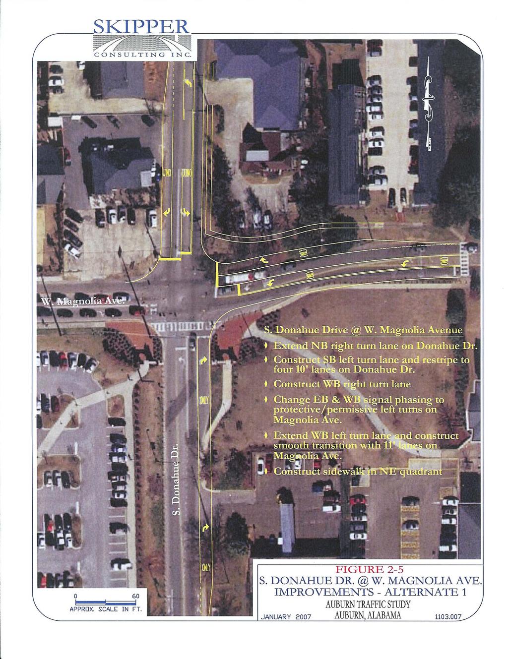
17 RECOMMENDED IMPROVEMENTS Based upon the analyses and evaluations conducted for the Donahue Drive Corridor, recommendations are being made to improve traffic flow along the corridor at study intersections and to address any capacity or safety deficiencies identified. The following outlines the recommended improvements for the Donahue Drive Corridor from Magnolia Avenue to Bragg Avenue. Donahue Drive Signal System In previous sections of this report, recommendations have been made regarding a signal system for Donahue Drive from Alabama Highway 14 south to Lem Morrison Drive. This would include the three study intersections (Alabama Highway 14, Glenn Avenue, and Magnolia Avenue) along Donahue Drive along with four other intersections on the Auburn University campus. Donahue Drive at Magnolia Avenue As a part of the recommended improvements for study intersections, two alternate improvement concepts have been included for the Donahue Drive at Magnolia Avenue intersection. Two alternate improvement concepts were developed for this intersection as a result of right-of-way limitations in the vicinity of the intersection, construction costs and the ability to implement potential improvements, potential capacity improvements, and Auburn University s desires to reduce congestion on Donahue Drive south of Magnolia Avenue. The following provides basic descriptions of the two alternate improvement concepts which have been included in the analyses for the Donahue Drive at Magnolia Avenue intersection: Alternate One Alternate One consists of widening the roadways at the study intersection to include typical turn lane additions such as adding right turn lanes. This Alternate would also include implementing signal phasing and timings modifications. Skipper Consulting, Inc. 14
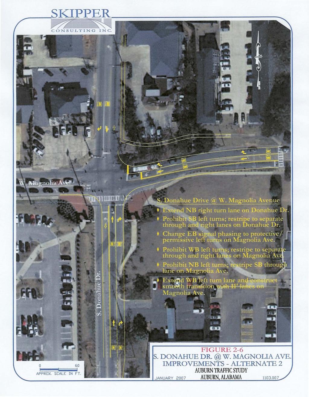
18 Alternate Two Alternate Two consists of limited roadway widening at the study intersection. The primary changes would be in prohibiting left turn movements for Northbound and Southbound Donahue Drive as well as Westbound Magnolia Avenue. Signal phasing and timing changes would also be included to accommodate the prohibited left turn movements. It is also recommended that the sidewalk in the northeast quadrant of the intersection be extended to Donahue Drive and to the north along the east side of Donahue Drive. As a part of implementing Alternate Two, reassignment of peak hour traffic volumes would occur. It is assumed that the westbound left turn movement from Magnolia Avenue would become through movements on Magnolia Avenue. It is also assumed that the left turn movements on northbound and southbound Donahue Drive would occur at locations prior to the study intersection given opportunities exist for such movements to occur with other routes providing access to assumed destinations. The reassigned peak hour traffic volumes assumed for the Donahue Drive at Magnolia Avenue intersection with the implementation of Alternate Two is provided in the following graphic. Donahue Dr. Donahue Dr. Magnolia Ave. Magnolia Ave. A.M. Peak Hour P.M. Peak Hour Skipper Consulting, Inc. 15
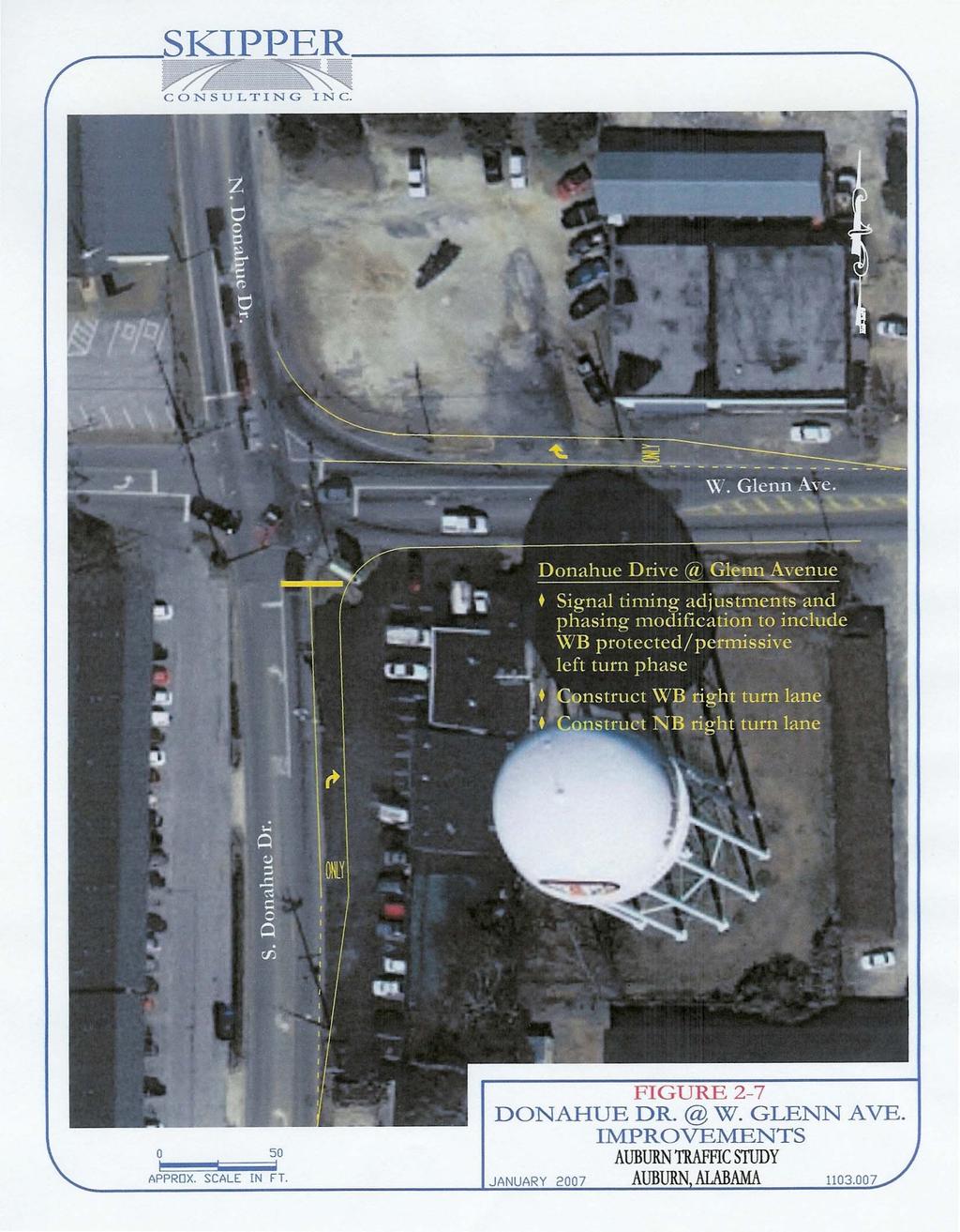
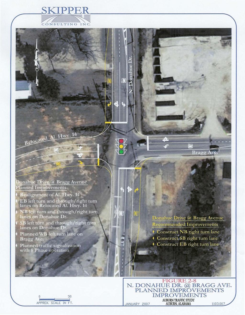
19 Donahue Drive at Glenn Avenue Signal timing and phasing modifications to include implementation of westbound protected/permissive left turn phasing. Construct a right turn lane for the westbound approach of Glenn Avenue. Construct a right turn lane for the northbound approach of Donahue Drive. Donahue Drive at Alabama Highway 14/Bragg Avenue As previously mentioned, an improvements project is planned by the ALDOT to realign Alabama Highway 14 to the north in alignment with Bragg Avenue. In order to accommodate the planned realignment, additional lanes are planned along Donahue Drive as well as Bragg Avenue and Alabama Highway 14. With the realignment completed, each approach of Donahue Drive, Bragg Avenue and Alabama Highway 14 would provide a left turn lane and a shared through/right turn lane. With the planned improvements project completed, the left turn lane on southbound Donahue Drive at Bragg Avenue, previously included as a warranted lane, would be constructed. In addition to the roadway improvements, signalization is planned for the Donahue Drive intersection with the realigned Alabama Highway 14 and Bragg Avenue. The realignment of Alabama Highway 14 is an assumed component in the evaluation of recommended improvements for Donahue Drive and has been included in the analyses. With the implementation of the planned realignment of Alabama Highway 14, current traffic at the Donahue Drive intersections with Alabama Highway 14 and Bragg Avenue would be redistributed. The following illustrates the assumed redistribution of peak hour traffic volumes for the Donahue Drive at Alabama Highway 14/Bragg Avenue intersection. These volumes were used in the analyses of this intersection. A comparison of reassigned peak hour traffic volumes with the right turn lane warrant criteria, previously presented, indicates peak hour volumes would be sufficient to meet the criteria for right turn lanes on both northbound and southbound Donahue Drive and eastbound Alabama Highway 14. These right turn lanes are recommended in addition to the planned improvements associated with the Alabama Highway 14 realignment project. Skipper Consulting, Inc. 16
20 Donahue Dr. Donahue Dr. AL 14 Bragg Ave. AL 14 Bragg Ave. A.M. Peak Hour P.M. Peak Hour Recommended improvements for each of the study intersections, including the planned improvements for the Alabama Highway 14 realignment, are illustrated in Figures 2-5 through 2-8 as summarized in the following: Figure 2-5 Donahue Drive at Magnolia Avenue Improvements Alternate One Figure 2-6 Donahue Drive at Magnolia Avenue Improvements Alternate Two Figure 2-7 Donahue Drive at Glenn Avenue Improvements Figure 2-8 Donahue Drive at AL Highway 14/Bragg Avenue - Planned and Recommended Improvements Skipper Consulting, Inc. 17
21
22
23
24
25 INTERSECTION CAPACITY ANALYSIS WITH RECOMMENDED AND PLANNED IMPROVEMENTS Capacity analyses were conducted for the study intersections along Donahue Drive with the recommended and planned improvements assumed to be in place. Capacity analyses were conducted using methods of the Highway Capacity Manual, as previously introduced. Table 2-4 provides a summary of the levels of service for study intersections assuming the recommended improvements would be implemented. For comparative purposes, existing levels of service are shown in red in Table 2-4. Capacity printouts are provided in Appendix C. As indicated in Table 2-4, acceptable levels of service would be provided for all movements/lane groups and approaches at each of the study intersections with the implementation of the recommended improvements as well as the planned realignment of Alabama Highway 14. Overall, each of the study intersections would operate at a level of service C. Table 2-4 also indicates that Alternate One or Alternate Two for the Donahue Drive at Magnolia Avenue intersection would yield similar levels of service. Under each Alternate, overall levels of service C would be provided at the Donahue Drive and Magnolia Avenue intersection for both peak periods evaluated. For comparative purposes, existing levels of service, where applicable, are provided in Table 2-4. Skipper Consulting, Inc. 22
26 Intersection (traffic control) Donahue Drive at Realigned AL 14/ Bragg Ave. (traffic signal) Donahue Drive at Glenn Avenue (traffic signal) Donahue Drive At Magnolia Avenue (traffic signal) Table 2-4 Intersection Levels of Service with Recommended Improvements and Planned Improvements Existing Levels of Service Shown in RED Approach Movement/Lane Group A.M. Peak Hour Level of Service P.M. Peak Hour Left C C EB AL 14 Through C C Right C C WB Bragg Avenue Left C C Through/Right C C Left B B NB Donahue Drive Through C C Right B B Left B B SB Donahue Drive Through C C Right B B Overall LOS C C EB Glenn Avenue WB Glenn Avenue NB Donahue Drive SB Donahue Drive Left C C C C Through/Right C C C C Left C D C D Through C C C Right A A Left B B B B Through C C C Right B B Left B A B B Through/Right C C C C Overall LOS C C C C Existing LOS Magnolia at Donahue Magnolia at Donahue AM PM Alt. 1 Alt. 2 Alt. 1 Alt. 2 EB Magnolia Left B C B B B C Avenue Through/Right B B C B C B Left B B B n/a B n/a WB Magnolia Avenue Through C C C C B B Right C B C C Left B B C n/a C n/a NB Donahue Drive Through B B C C C D Right B B B C B C Left B B C n/a C n/a SB Donahue Drive Through C C C C D B Right B B B B Overall LOS C B C C C C D D Skipper Consulting, Inc. 23
27 ARTERIAL SEGMENT CAPACITY ANALYSES WITH RECOMMENDED AND PLANNED IMPROVEMENTS Arterial segment capacity analyses for peak hour conditions along the Donahue Drive Corridor were conducted for the morning and afternoon peak hours using methods outlined in the Highway Capacity Manual, Third Edition. These analyses were conducted assuming the Alabama Highway 14 realignment would be in place. In addition, analyses were conducted with both Alternate One and Alternate Two for the Donahue Drive at Magnolia Avenue intersection. Levels of service for the arterial analyses conducted for Donahue Drive are summarized in Table 2-5. For comparative purposes, existing levels of service are provided in red in Table 2-5. Capacity printouts are provided in Appendix C. From Table 2-5 Arterial Segment Levels of Service with Recommended Improvements and Planned Improvements Existing Levels of Service in RED To Northbound Donahue Drive Arterial Analysis Arterial Level of Service by Section Existing Magnolia at Donahue Magnolia at Donahue Segment Conditions Alternate One Alternate Two Length AM PM AM PM AM PM (miles) Peak Peak Peak Peak Peak Peak Magnolia Ave. Glenn Ave D D D D D D Glenn Ave. AL 14/Bragg 0.12 D D D D D D From Total Urban Street LOS D D D D D D To Southbound Donahue Drive Arterial Analysis Arterial Level of Service by Section Existing Magnolia at Donahue Magnolia at Donahue Segment Conditions Alternate One Alternate Two Length AM PM AM PM AM PM (miles) Peak Peak Peak Peak Peak Peak AL 14/Bragg Glenn Ave E E D D D D Glenn Ave. Magnolia Ave D C D D D D Total Urban Street LOS E D D D D D Skipper Consulting, Inc. 24
28 Table 2-5 indicates that the total urban street level of service along Donahue Drive from Alabama Highway 14/Bragg Avenue to Magnolia Avenue would operate at levels of service D for each direction of travel during both the morning and afternoon peak hours. Levels of service for either Alternate One or Alternate Two at the Donahue Drive at Magnolia Avenue intersection would yield the similar levels of service for the Donahue Drive arterial analysis. This analysis was conducted assuming the roadway and traffic control improvements (both recommended and planned) outlined in this report would be in place. Skipper Consulting, Inc. 25
Glenn Avenue Corridor Traffic Operational Evaluation
 Glenn Avenue Corridor Traffic Operational Evaluation PREPARED FOR: THE CITY OF AUBURN PREPARED BY: DECEMBER 2007 Glenn Avenue Corridor Study--Auburn, Alabama TABLE OF CONTENTS Introduction... 1 Background
Traffic Impact Analysis Chatham County Grocery Chatham County, NC
 Chatham County Grocery Chatham County, NC TABLE OF CONTENTS 1. INTRODUCTION... 1 1.1. Location and Study Area... 1 1.2. Proposed Land Use and Access... 2 1.3. Adjacent Land Uses... 2 1.4. Existing ways...
Traffic Impact Analysis Walton Acres at Riverwood Athletic Club Clayton, NC
 Traffic Impact Analysis Walton Acres at Riverwood Athletic Club Clayton, NC 1. TABLE OF CONTENTS INTRODUCTION...1 1.1. Site Location and Study Area...1 1.2. Proposed Land Use and Site Access...2 1.3.
Traffic Impact Study. Westlake Elementary School Westlake, Ohio. TMS Engineers, Inc. June 5, 2017
 TMS Engineers, Inc. Traffic Impact Study Westlake Elementary School Westlake, Ohio June 5, 2017 Prepared for: Westlake City Schools - Board of Education 27200 Hilliard Boulevard Westlake, OH 44145 TRAFFIC
5858 N COLLEGE, LLC N College Avenue Traffic Impact Study
 5858 N COLLEGE, LLC nue Traffic Impact Study August 22, 2016 Contents Traffic Impact Study Page Preparer Qualifications... 1 Introduction... 2 Existing Roadway Conditions... 5 Existing Traffic Conditions...
Traffic Impact Study Little Egypt Road Development Denver, North Carolina June 2017
 Traffic Impact Study Little Egypt Road Development Denver, North arolina June 2017 N. Little Egypt Road DQ\ QDQFLQJ VDOHV RU RWKHU SHUIRUPDQFH EDVHG FULWHULD Proposed Site Driveways Site Driveway 1 TRAFFI
Shockoe Bottom Preliminary Traffic and Parking Analysis
 Shockoe Bottom Preliminary Traffic and Parking Analysis Richmond, Virginia August 14, 2013 Prepared For City of Richmond Department of Public Works Prepared By 1001 Boulders Pkwy Suite 300, Richmond, VA
INDUSTRIAL BUILDING 3009 HAWTHORNE ROAD CITY OF OTTAWA TRANSPORTATION OVERVIEW REVISED. Prepared for: Canada Inc.
 INDUSTRIAL BUILDING 3009 HAWTHORNE ROAD CITY OF OTTAWA TRANSPORTATION OVERVIEW REVISED Prepared for: 7849648 Canada Inc. Octiober 1, 2015 114-598 Overview_2.doc D. J. Halpenny & Associates Ltd. Consulting
Traffic Study North Shore School District 112
 Traffic Study North Shore School District 112 Proposed Expansion of Northwood Junior High School Prepared By: May 1, 2015 1. Introduction Kenig, Lindgren, O Hara, Aboona, Inc. (KLOA, Inc.) has been retained
THE LANDMARK AT TALBOT PARK
 TRAFFIC IMPACT STUDY FOR THE LANDMARK AT TALBOT PARK IN NORFOLK, VA INTERMODAL ENGINEERING, P.C. OCTOBER, 200 The Landmark at Talbot Park is a proposed redevelopment of the existing apartments along the
MEDICAL/OFFICE BUILDING 1637 BANK STREET OTTAWA, ONTARIO TRANSPORTATION OVERVIEW. Prepared for:
 MEDICAL/OFFICE BUILDING 1637 BANK STREET OTTAWA, ONTARIO TRANSPORTATION OVERVIEW Prepared for: 2434984 Ontario Inc. 13-5510 Canotek Road Ottawa, Ontario K1J 9J5 June 4, 2015 115-613 Report_2.doc D. J.
MEETING FACILITY 2901 GIBFORD DRIVE CITY OF OTTAWA TRANSPORTATION BRIEF. Prepared for: Holiday Inn Express 2881 Gibford Drive Ottawa, ON K1V 2L9
 MEETING FACILITY 2901 GIBFORD DRIVE CITY OF OTTAWA TRANSPORTATION BRIEF Prepared for: Holiday Inn Express 2881 Gibford Drive Ottawa, ON K1V 2L9 December 18, 2012 112-566 Brief_1.doc D. J. Halpenny & Associates
FINAL DESIGN TRAFFIC TECHNICAL MEMORANDUM
 FINAL DESIGN TRAFFIC TECHNICAL MEMORANDUM July 2014 FINAL (SR 43) Project Development and Environment Study From State Road 60 (Adamo Drive) to I-4 (SR 400) Hillsborough County, Florida Work Program Item
QUICKIE C STORE AND GAS BAR 1780 HERON ROAD OTTAWA, ONTARIO TRANSPORTATION BRIEF. Prepared for:
 QUICKIE C STORE AND GAS BAR 1780 HERON ROAD OTTAWA, ONTARIO TRANSPORTATION BRIEF Prepared for: Quickie Convenience Stores Larny Holdings Ltd. c/o PBC Group April 15, 2015 115-615 Report_1.doc D. J. Halpenny
Intersection Traffic Control Feasibility Study
 Intersection Traffic Control Feasibility Study CSAH 9 at CSAH 60 (185th Avenue) Prepared For: Dakota County Transportation Department Western Service Center 14955 Galaxie Avenue, 3rd Floor Apple Valley,
Evaluation of M-99 (Broad Street) Road Diet and Intersection Operational Investigation
 Road Diet and Intersection Operational Investigation") Evaluation of M-99 (Broad Street) Road Diet and Intersection Operational Investigation City of Hillsdale, Hillsdale County, Michigan June 16, 2016 Final Report Prepared for City of Hillsdale 97 North Broad
Evaluation of M-99 (Broad Street) Road Diet and Intersection Operational Investigation City of Hillsdale, Hillsdale County, Michigan June 16, 2016 Final Report Prepared for City of Hillsdale 97 North Broad
Traffic Impact Study WestBranch Residential Development Davidson, NC March 2016
 Traffic Impact Study WestBranch Residential Development Davidson, NC March 216 TRAFFIC IMPACT STUDY FOR THE WestBranch Residential Development LOCATED IN DAVIDSON, NC Prepared For: Lennar Carolinas, LLC
FRONT RANGE CROSSINGS TRAFFIC IMPACT STUDY
 FRONT RANGE CROSSINGS TRAFFIC IMPACT STUDY Prepared for: City of Thornton And Colorado Department of Transportation Prepared by: 11 Blake Street, Suite 2 Denver, Colorado 822 Contact: Brian Bern, PE, PTOE
TRANSPORTATION ANALYSIS REPORT US Route 6 Huron, Erie County, Ohio
 TRANSPORTATION ANALYSIS REPORT US Route 6 Huron, Erie County, Ohio December 12, 2012 Prepared for: The City of Huron 417 Main Huron, OH 44839 Providing Practical Experience Technical Excellence and Client
FORM A PASCO COUNTY ACCESS CONNECTION PERMIT APPLICATION
 FORM 901.3.A PASCO COUNTY ACCESS CONNECTION PERMIT APPLICATION The following information is required from all applicants directly or indirectly accessing any collector or arterial road or as otherwise
TRAFFIC IMPACT STUDY COMPREHENSIVE UPDATE TOWN OF THOMPSON S STATION, TENNESSEE PREPARED FOR: THE TOWN OF THOMPSON S STATION
 TRAFFIC IMPACT STUDY COMPREHENSIVE UPDATE TOWN OF THOMPSON S STATION, TENNESSEE PREPARED FOR: THE TOWN OF THOMPSON S STATION Transportation Consultants, LLC 1101 17 TH AVENUE SOUTH NASHVILLE, TN 37212
Capital Region Council of Governments
 March 23, 2018 Capital Region Council of Governments PROJECT CONCEPT REPORT Realignment of Swamp and Northfield Road s approaches to Route 44 (Boston Turnpike) Town of Coventry SUMMARY: The Town of Coventry
Traffic Circulation Study for Neighborhood Southwest of Mockingbird Lane and Airline Road, Highland Park, Texas
 ARIZONA TEXAS NEW MEXICO OKLAHOMA February 13, 2015 Mr. Meran Dadgostar P.E., R.S. Town of Highland Park 4700 Drexel Dr. Highland Park, Texas 75205 Re: Traffic Circulation Study for Neighborhood Southwest
ALLEY 24 TRAFFIC STUDY
 ALLEY 24 TRAFFIC STUDY in City of Frostburg, Maryland January 2013 3566 Teays Valley Road Hurricane, WV Office: (304) 397-5508 www.denniscorporation.com Alley 24 Traffic Study January 2013 Frostburg, Maryland
DRAFT. Corridor study. Honeysuckle Road. October Prepared for the City of Dothan, AL. Prepared by Gresham, Smith and Partners
 DRAFT Corridor study Honeysuckle Road October 2017 Prepared for the City of Dothan, AL Prepared by TABLE OF CONTENTS SECTION I... 1 STUDY SUMMARY... 1 INTRODUCTION... 1 CONCLUSIONS... 5 SECTION II... 7
THIS PAGE LEFT BLANK INTENTIONALLY
 GA SR 25 Spur at Canal Road Transportation Impact Analysis PREPARED FOR GLYNN COUNTY, GEORGIA 1725 Reynolds Street, Suite 300 Brunswick, Georgia 31520 PREPARED BY 217 Arrowhead Boulevard Suite 26 Jonesboro,
TRAFFIC IMPACT STUDY. Creekside Thornton, Colorado. For. August 2015 November 2015 Revised: August Prepared for:
 TRAFFIC IMPACT STUDY For Creekside Thornton, Colorado August 215 November 215 Revised: August 216 Prepared for: Jansen Strawn Consulting Engineers 45 West 2 nd Avenue Denver, Colorado 8223 Prepared by:
Meadowlake Ranch Traffic Impact Analysis (LSC #184600) August 27, 2018
 August 27, 2018") LSC TRANSPORTATION CONSULTANTS, INC. 545 East Pikes Peak Avenue, Suite 210 Colorado Springs, CO 80903 (719) 633-2868 FAX (719) 633-5430 E-mail: lsc@lsctrans.com Website: http://www.lsctrans.com Traffic
LSC TRANSPORTATION CONSULTANTS, INC. 545 East Pikes Peak Avenue, Suite 210 Colorado Springs, CO 80903 (719) 633-2868 FAX (719) 633-5430 E-mail: lsc@lsctrans.com Website: http://www.lsctrans.com Traffic
Highway 111 Corridor Study
 Highway 111 Corridor Study June, 2009 LINCOLN CO. HWY 111 CORRIDOR STUDY Draft Study Tea, South Dakota Prepared for City of Tea Sioux Falls Metropolitan Planning Organization Prepared by HDR Engineering,
Walmart (Store # ) 60 th Street North and Marion Road Sioux Falls, South Dakota
 60 th Street North and Marion Road Sioux Falls, South Dakota") Walmart (Store #4865-00) 60 th Street North and Marion Road Sioux Falls, South Dakota Prepared for: Wal-Mart Stores, Inc. Bentonville, Arkansas Prepared by: Kimley-Horn and Associates, Inc. ã2013 Kimley-Horn
Walmart (Store #4865-00) 60 th Street North and Marion Road Sioux Falls, South Dakota Prepared for: Wal-Mart Stores, Inc. Bentonville, Arkansas Prepared by: Kimley-Horn and Associates, Inc. ã2013 Kimley-Horn
Chapter 4 Traffic Analysis
 Chapter 4 Traffic Analysis PURPOSE The traffic analysis component of the K-68 Corridor Management Plan incorporates information on the existing transportation network, such as traffic volumes and intersection
Harrah s Station Square Casino
 Transportation Analysis Harrah s Station Square Casino Pittsburgh, Pennsylvania Submitted To: City of Pittsburgh and Pennsylvania Gaming Control Board Prepared By: DKS Associates GAI Consultants December
TRANSPORTATION IMPACT STUDY PROPOSED RIVERFRONT 47 MIXED USE DEVELOPMENT
 November 2016 TRANSPORTATION IMPACT STUDY PROPOSED RIVERFRONT 47 MIXED USE DEVELOPMENT & Aspinwall Borough, Sharpsburg Borough & O Hara Township, Allegheny County, Pennsylvania Prepared for: Riverfront
Existing Conditions. Date: April 16 th, Dan Holderness; Coralville City Engineer Scott Larson; Coralville Assistant City Engineer
 Date: April 16 th, 2015 To: From: Re: Dan Holderness; Coralville City Engineer Scott Larson; Coralville Assistant City Engineer Darian Nagle-Gamm, Traffic Engineering Planner Highway 6 (2 nd Street) /
Walton Acres at Riverwood Athletic Club Clayton, North Carolina
 9. CONCLUSIONS This Traffic Impact Analysis Update was conducted to determine the potential traffic impacts of the proposed Walton Acres at Riverwood Athletic Club residential development, located east
Marina Loft (DRC 51-R-12)
") Marina Loft (DRC 51-R-12) traffic study prepared for: Cymbal Development OCtober 2012 Traf Tech October 1, 2012 Mr. Asi Cymbal - President Cymbal Development 3470 North Miami Avenue Upper Suite Miami,
Marina Loft (DRC 51-R-12) traffic study prepared for: Cymbal Development OCtober 2012 Traf Tech October 1, 2012 Mr. Asi Cymbal - President Cymbal Development 3470 North Miami Avenue Upper Suite Miami,
METHODOLOGY. Signalized Intersection Average Control Delay (sec/veh)
") Chapter 5 Traffic Analysis 5.1 SUMMARY US /West 6 th Street assumes a unique role in the Lawrence Douglas County transportation system. This principal arterial street currently conveys commuter traffic
Chapter 5 Traffic Analysis 5.1 SUMMARY US /West 6 th Street assumes a unique role in the Lawrence Douglas County transportation system. This principal arterial street currently conveys commuter traffic
INDUSTRIAL BUILDING 1660 COMSTOCK ROAD CITY OF OTTAWA TRANSPORTATION OVERVIEW. Prepared for:
 INDUSTRIAL BUILDING 1660 COMSTOCK ROAD CITY OF OTTAWA TRANSPORTATION OVERVIEW Prepared for: Simluc Contractors Limited 2550 Blackwell Street, Ottawa K1B 5R1 October 18, 2013 113-584 Overview_1.doc D. J.
3.2.2 Proposed Road Network within Phase 1B Lands
 3.2.2 Proposed Road Network within Phase 1B Lands Figure 3.1 also shows the proposed road network within the Premier Gateway Phase 1B Employment Area lands, which features two collector roads providing
DUNBOW ROAD FUNCTIONAL PLANNING
 DUNBOW ROAD FUNCTIONAL PLANNING Final Report August 3, 216 #31, 316 5th Avenue NE Calgary, AB T2A 6K4 Phone: 43.273.91 Fax: 43.273.344 wattconsultinggroup.com Dunbow Road Functional Planning Final Report
Northwest Corridor Project Interchange Modification, Interchange Justification and System Analysis Report Reassessment (Phase I)
") Northwest Corridor Project Interchange Modification, Interchange Justification and System Analysis Report Reassessment (Phase I) Introduction The Georgia Department of Transportation (GDOT) prepared a
Northwest Corridor Project Interchange Modification, Interchange Justification and System Analysis Report Reassessment (Phase I) Introduction The Georgia Department of Transportation (GDOT) prepared a
OTTAWA TRAIN YARDS PHASE 3 DEVELOPMENT CITY OF OTTAWA TRANSPORTATION IMPACT STUDY. Prepared for:
 OTTAWA TRAIN YARDS PHASE 3 DEVELOPMENT CITY OF OTTAWA TRANSPORTATION IMPACT STUDY Prepared for: The Ottawa Train Yards Inc. 223 Colonnade Road South, Suite 212 Nepean, Ontario K2E 7K3 January 17, 2012
PINESTONE TRAFFIC IMPACT STUDY Travelers Rest, South Carolina
 PINESTONE TRAFFIC IMPACT STUDY Travelers Rest, South Carolina Prepared for Longbranch Development Prepared by January 13, 219 ii Table of Contents Subject Page Signature Page... i Table of Contents...
TRAFFIC IMPACT STUDY And A TRAFFIC SIGNAL WARRANT ANALYSIS FOR A SENIOR LIVING AND APARTMENT DEVELOPMENT
 TRAFFIC IMPACT STUDY And A TRAFFIC SIGNAL WARRANT ANALYSIS FOR A SENIOR LIVING AND APARTMENT DEVELOPMENT DEERFIELD TOWNSHIP, WARREN COUNTY, OHIO Nantucket Circle and Montgomery Road () Prepared for: ODLE
4.0 TRAFFIC IMPACT STUDIES
 SECTION 4 4.0 TRAFFIC IMPACT STUDIES 4.1 TRAFFIC IMPACT STUDY REQUIREMENTS The City has established Traffic Impact Study (TIS) requirements for the purpose of ensuring that both the quantitative and qualitative
URBAN QUARRY HEADQUARTERS 2717 STEVENAGE DRIVE CITY OF OTTAWA TRANSPORTATION OVERVIEW. Prepared for: Urban Quarry 4123 Belgreen Drive, Ottawa K1G 3N2
 URBAN QUARRY HEADQUARTERS 2717 STEVENAGE DRIVE CITY OF OTTAWA TRANSPORTATION OVERVIEW Prepared for: Urban Quarry 4123 Belgreen Drive, Ottawa K1G 3N2 February 27, 2014 113-584 Overview_1.doc D. J. Halpenny
OFFICE/RETAIL DEVELOPMENT 1625 BANK STREET OTTAWA, ONTARIO TRANSPORTATION BRIEF. Prepared for: Canada Inc.
 OFFICE/RETAIL DEVELOPMENT 1625 BANK STREET OTTAWA, ONTARIO TRANSPORTATION BRIEF Prepared for: 9402209 Canada Inc. December 15, 2015 115-625 Report_2.doc D. J. Halpenny & Associates Ltd. Consulting Transportation
Project Report. South Kirkwood Road Traffic Study. Meadows Place, TX October 9, 2015
 Meadows Place, TX October 9, 2015 Contents 1 Introduction... 1 2 Data Collection... 1 3 Existing Roadway Network... 2 4 Traffic Volume Development... 2 5 Warrant Analysis... 3 6 Traffic Control Alternative
Road Conversion Study Plumas Street
 Plumas Street Phase I Submitted to The Regional Transportation Commission of Washoe County Submitted by Zong Tian, Ph.D., P.E. Saeedeh Farivar Haiyuan Li, Ph.D. Center for Advanced Transportation Education
EXECUTIVE SUMMARY. Page 1 of 6
 EXECUTIVE SUMMARY The purpose of this report is to identify conformance with the original traffic impact study for the proposed retail development on Lot 5 of Riverdale Retail Filing No. 1 located on the
NEW YORK CENTRAL PARK SUBDIVISION BLAIS STREET/ST-PIERRE STREET EMBRUN, ONTARIO TRAFFIC IMPACT STUDY. Prepared for:
 NEW YORK CENTRAL PARK SUBDIVISION BLAIS STREET/ST-PIERRE STREET EMBRUN, ONTARIO TRAFFIC IMPACT STUDY Prepared for: Solidex Holdings Limited & Investissement Maurice Lemieux Investments Attn: Mr. Anthony
I-264 CORRIDOR EVALUATION STUDY. September 7, 2016 Eric Stringfield VDOT Planning Director Chris Lawrence AECOM Senior Transportation Engineer
 I-264 CORRIDOR EVALUATION STUDY September 7, 2016 Eric Stringfield VDOT Planning Director Chris Lawrence AECOM Senior Transportation Engineer Study Overview Interchange Locations Study Context Follow-up
Figure 1: Vicinity Map of the Study Area
 ARIZONA TEXAS NEW MEXICO OKLAHOMA May 5, 2016 Mr. Anthony Beach, P.E. BSP Engineers 4800 Lakewood Drive, Suite 4 Waco, Texas 76710 Re: Intersection and Access Analysis along Business 190 in Copperas Cove
Date: September 7, Project #: Re: Spaulding Youth Center Northfield, NH Property. Traffic Impact Study
 To: Ms. Susan C. Ryan Spaulding Youth Center 72 Spaulding Road Northfield, NH 03276 Date: September 7, 2017 Project #: 52455.00 From: Robin Bousa Director of Transportation Systems Re: Spaulding Youth
Transportation Impact Study for Abington Terrace
 Transportation Impact Study for Abington Terrace Abington Township, Montgomery County, PA Sandy A. Koza, P.E., PTOE PA PE License Number PE059911 Prepared by McMahon Associates, Inc. 425 Commerce Drive,
HILTON GARDEN INN HOTEL HOTEL EXPANSION 2400 ALERT ROAD, OTTAWA TRANSPORTATION BRIEF. Prepared for:
 HILTON GARDEN INN HOTEL HOTEL EXPANSION 2400 ALERT ROAD, OTTAWA TRANSPORTATION BRIEF Prepared for: Bona Building & Management Co. Ltd. Place Vanier, 333 North River Road Vanier, Ontario K1L 8B9 October
STILLWATER AVENUE CORRIDOR STUDY Old Town, Maine
 Draft Study STILLWATER AVENUE CORRIDOR STUDY Old Town, Maine SUBMITTED TO: BANGOR AREA COMPREHENSIVE TRANSPORTATION SYSTEM SUBMITTED BY: I MAY 23, 2017 DRAFT STILLWATER AVENUE STUDY FINAL REPORT Table
CarMax Auto Superstore/ Reconditioning Center #6002 Murrieta, California
 CarMax Auto Superstore/ Reconditioning Center #6002 Murrieta, California TUSTIN 17782 17th Street Suite 200 Tustin, CA 92780-1947 714.665.4500 Fax: 714.665.4501 LOS ANGELES 145 S. Spring Street Suite 120
Cheyenne Metropolitan Planning Organization
 Dell Range Boulevard Corridor Study PHASE II SECTION 20 DRAFT Prepared for: Cheyenne Metropolitan Planning Organization November 20, 2015 (Section 20 is bordered by Powderhouse Road on the west, Storey
INTERSECTION SAFETY STUDY State Route 57 / Seville Road
 INTERSECTION SAFETY STUDY State Route 57 / Seville Road City of Wadsworth, Medina County, Ohio Prepared For: City of Wadsworth Engineering Department 120 Maple Street Wadsworth, OH 44281 Prepared By: GPD
Appendix C. NORTH METRO STATION AREA TRAFFIC IMPACT STATEMENT 88th Avenue Station
 Appendix C NORTH METRO STATION AREA TRAFFIC IMPACT STATEMENT 88th Avenue Station Prepared for: Regional Transportation Department and URS Corporation as part of the North Metro EIS David Evans and Associates,
HOLIDAY INN HOTEL 235 KING EDWARD AVENUE CITY OF OTTAWA TRANSPORTATION BRIEF. Prepared for:
 HOLIDAY INN HOTEL 235 KING EDWARD AVENUE CITY OF OTTAWA TRANSPORTATION BRIEF Prepared for: Momentum Planning & Communications 1165 Greenlawn Crescent Ottawa, ON K1L 6C2 June 29, 2015 115-618 Brief_1.doc
Traffic Impact Study. Crestline Piggly Wiggly Mountain Brook, Alabama. Goodwyn, Mills and Cawood, Inc. Birmingham, Alabama.
 Traffic Impact Study Crestline Piggly Wiggly Mountain Brook, Alabama Prepared for: Goodwyn, Mills and Cawood, Inc. Birmingham, Alabama September 214 Revision 1 October 214 Crestline Piggly Wiggly Mountain
CITY OF SPOKANE VALLEY Request for Council Action
 CITY OF SPOKANE VALLEY Request for Council Action Meeting Date: December 16, 2014 Department Director Approval: Check all that apply: consent old business new business public hearing information admin.
Bridge Street Corridor Study Report
 Bridge Street Corridor Study Report Prepared for: Prepared by: BRIDGE STREET CORRIDOR STUDY REPORT PREPARED FOR: CITY OF ARROYO GRANDE COMMUNITY DEVELOPMENT DEPARTMENT 300 EAST BRANCH STREET ARROYO GRANDE,
APARTMENT BUILDING DEVELOPMENT 1161 HERON ROAD OTTAWA, ONTARIO TRANSPORTATION IMPACT STUDY. Prepared for:
 APARTMENT BUILDING DEVELOPMENT 1161 HERON ROAD OTTAWA, ONTARIO TRANSPORTATION IMPACT STUDY Prepared for: 1649362 Ontario Inc. c/o Manor Park Management 231 Brittany Drive, Suite D Ottawa ON K1K 0R8 July
List of Exhibits...ii
 One Brickell Traffic Study TABLE OF CONTENTS List of Exhibits...ii EXECUTIVE SUMMARY...1 1. INTRODUCTION...2 1.1 Study Area...2 1.2 Study Objective...5 2. EXISTING TRAFFIC CONDITIONS...6 2.1 Data Collection...6
APPENDIXB. Traffic Operations Technical Memorandum
 APPENDIXB Traffic Operations Technical Memorandum Environmental Assessment - Lincoln County, SD 85 th Street: Sundowner Avenue to Louise Avenue November 2017 MEMORANDUM Transportation Jim Kollbaum, PE
M-58 HIGHWAY ACCESS MANAGEMENT STUDY Mullen Road to Bel-Ray Boulevard. Prepared for CITY OF BELTON. May 2016
 M-58 HIGHWAY ACCESS MANAGEMENT STUDY Prepared for CITY OF BELTON By May 2016 Introduction Missouri State Highway 58 (M-58 Highway) is a major commercial corridor in the City of Belton. As development has
A plan for improved motor vehicle access on Railroad Avenue in Provincetown
 A plan for improved motor vehicle access on Railroad Avenue in Provincetown February 2011 A plan for improved motor vehicle access on Railroad Avenue in Provincetown INTRODUCTION AND PROBLEM IDENTIFICATION
Draft Report. Traffic Impact Study. Superstore, Wal-Mart, and Kent Development. Yarmouth, Nova Scotia. Prepared for
 oad & Traffic Management Road & Traffic Management R Atlantic Traffic Engineering Specialists Draft Report Traffic Impact Study Superstore, Wal-Mart, and Kent Development Yarmouth, Nova Scotia Prepared
MoPac South: Impact on Cesar Chavez Street and the Downtown Network
 MoPac South: Impact on Cesar Chavez Street and the Downtown Network Prepared by: The University of Texas at Austin Center for Transportation Research Prepared for: Central Texas Regional Mobility Authority
DEPARTMENT OF ENVIRONMENTAL SERVICES. North Harrison Street (Lee Highway to Little Falls Road) Comparative Analysis. Prepared for:
 Comparative Analysis. Prepared for:") DEPARTMENT OF ENVIRONMENTAL SERVICES North Harrison Street (Lee Highway to Little Falls Road) Comparative Analysis Prepared for: Arlington County Department of Environmental Services 2100 Clarendon Boulevard,
DEPARTMENT OF ENVIRONMENTAL SERVICES North Harrison Street (Lee Highway to Little Falls Road) Comparative Analysis Prepared for: Arlington County Department of Environmental Services 2100 Clarendon Boulevard,
Traffic Impact Statement
 Traffic Impact Statement Mixed Use Development, US 41 and Old Trail Drive aka Tide-Starbucks 4900 9 th Street North General Development Site Plan (GDSP) Collier County, FL 10/6/2015 Prepared for: Prepared
Bistro 6. City of Barrie. Traffic Impact Study for Pratt Hansen Group Inc. Type of Document: Final Report. Project Number: JDE 1748
 City of Barrie Traffic Impact Study for Pratt Hansen Group Inc. Type of Document: Final Report Project Number: JDE 1748 Date Submitted: June 12 th, 2017 06/12/17 John Northcote, P.Eng. Professional License
Include autoturn exhibits of WB-67 trucks at each roundabout.
 1 Along the through path, the desired relationship is R1>R2
TABLE OF CONTENTS TABLE OF CONTENTS... I APPENDICES... III LIST OF EXHIBITS... V LIST OF TABLES... VII LIST OF ABBREVIATED TERMS...
 TABLE OF CONTENTS TABLE OF CONTENTS... I APPENDICES... III LIST OF EXHIBITS... V LIST OF TABLES... VII LIST OF ABBREVIATED TERMS... IX 1 INTRODUCTION... 1 1.1 Project Overview... 1 1.2 Analysis Scenarios...
Transportation Advisory Board
 C I T Y O F WEATHERFORD Transportation Advisory Board AGENDA REPORT Meeting Date: October 15,2015 Staff Contact: Manny Palacios Jr. Phone: E-mail: 817-598-4296 mpalacios@weatherfordtx.gov SUBJECT: Discuss
Interstate Route 77 / US Route 62 / State Route 687 (Fulton Road) Transportation Improvement Project. Prepared September 6, 2017
 Transportation Improvement Project. Prepared September 6, 2017") EODOT Project: ODOT Project: STA-IR 77-.50; PID 00290 Interstate Route 77 / US Route 62 / State Route 687 (Fulton Road) Transportation Improvement Project Summary of Public Comments Received and Responses
EODOT Project: ODOT Project: STA-IR 77-.50; PID 00290 Interstate Route 77 / US Route 62 / State Route 687 (Fulton Road) Transportation Improvement Project Summary of Public Comments Received and Responses
King Soopers #116 Thornton, Colorado
 Traffic Impact Study King Soopers #116 Thornton, Colorado Prepared for: Galloway & Company, Inc. 1.0 EXECUTIVE SUMMARY King Soopers #116, a grocery marketplace anchored commercial development, is proposed
Traffic Impact Study. Roderick Place Columbia Pike Thompson s Station, TN. Transportation Group, LLC Traffic Engineering and Planning
 F i s c h b a c h Transportation Group, LLC Traffic Engineering and Planning Traffic Impact Study Roderick Place Columbia Pike Thompson s Station, TN Prepared March 2016 Ms. Gillian L. Fischbach, P.E.,
City of Homewood Transportation Plan
 City of Homewood Transportation Plan Prepared for: City of Homewood, Alabama Prepared by: Skipper Consulting, Inc. May 2007 TABLE OF CONTENTS INTRODUCTION... 1 BACKGROUND INFORMATION... 1 EXISTING TRANSPORTATION
4.0 TRANSPORTATION SYSTEMS
 Transportation Systems 4.0 TRANSPORTATION SYSTEMS This chapter examines the impacts of the Central Corridor Extension on existing roadways and traffic operations and discusses the transit service, operations,
TRAFFIC STUDY GUIDELINES Clarksville Street Department
 TRAFFIC STUDY GUIDELINES Clarksville Street Department 9/1/2009 Introduction Traffic studies are used to help the city determine potential impacts to the operation of the surrounding roadway network. Two
Dr. M.L. King, Jr. Street North Complete Streets Resurfacing Opportunities HOUSING, LAND USE, AND TRANSPORTATION COMMITTEE MARCH 22, 2018
 Dr. M.L. King, Jr. Street North Complete Streets Resurfacing Opportunities HOUSING, LAND USE, AND TRANSPORTATION COMMITTEE MARCH 22, 2018 What s Happening The City plans to mill and resurface Dr. M.L.
Toronto and East York Community Council. Director, Transportation Services, Toronto and East York District
 No Turn on Red Regulations STAFF REPORT ACTION REQUIRED Date: June 1, 2010 To: From: Toronto and East York Community Council Director, Transportation Services, Toronto and East York District Wards: Trinity
FAIRFIELD INN & SUITES HOTEL 135 THAD JOHNSON PRIVATE OTTAWA TRANSPORTATION BRIEF. Prepared for:
 FAIRFIELD INN & SUITES HOTEL 135 THAD JOHNSON PRIVATE OTTAWA TRANSPORTATION BRIEF Prepared for: Bona Building & Management Co. Ltd. Place Vanier, 333 North River Road Vanier, Ontario K1L 8B9 August 12,
TRASBURG RANSPORTATION
 TRASBURG RANSPORTATION LAN DEVELOPED BY THE TRANSPORTATION PLANNING DIVISION OF THE VIRGINIA DEPARTMENT OF TRANSPORTATION IN COOPERATION WITH THE U.S. DEPARTMENT OF TRANSPORTATION, FEDERAL HIGHWAY ADMINISTRATION
TABLE OF CONTENTS FEASIBILITY REPORT
 TABLE OF CONTENTS 1.0 Executive Summary... 1 2.0 Introduction... 6 2.1 BACKGROUND... 6 2.2 PURPOSE OF STUDY... 7 2.3 STUDY AREA... 8 2.4 STUDY PROCESS / STAKEHOLDER INVOLVEMENT... 8 3.0 Summary of Freeways
TABLE TRAFFIC ANALYSIS SCENARIOS
 4.11 TRANSPORTATION The potential traffic impacts of the proposed project are evaluated in the Buena Park Beach/Orangethorpe Mixed Use Project Traffic Analysis (Traffic Analysis) by Austin-Foust Associates
122 Avenue: 107 Street to Fort Road
 : 107 Street to Fort Road November 24, 2015 4:30 8:00 p.m. Meeting Purpose Summarize project work completed to date Share results of public input from Phase 1 Share the draft concept plan and proposed
 TRAFFIC IMPACT STUDY CANYON HILLS PROJECT LOS ANGELES, CALIFORNIA INTRODUCTION This traffic analysis has been conducted to identify and evaluate the potential traffic impacts of the proposed Canyon Hills
Gateway Transportation Study
 Gateway Transportation Study Amherst, Massachusetts SUBMITTED TO University of Massachusetts Amherst Town of Amherst SUBMITTED BY Vanasse Hangen Brustlin, Inc. Watertown, Massachusetts March 213 Back of
4. ENVIRONMENTAL IMPACT ANALYSIS 9. TRANSPORTATION AND TRAFFIC
 4. ENVIRONMENTAL IMPACT ANALYSIS 9. TRANSPORTATION AND TRAFFIC 4.9.1 INTRODUCTION The following section addresses the Proposed Project s impact on transportation and traffic based on the Traffic Study
Reference number /VP. Lafayette Downtown Congestion Study - Additional Traffic Analysis
 To James Hinkamp and Tony Coe, City of Lafayette Date January 19, 2017 Copies Reference number 243381/VP From Michael Iswalt and Vanessa Peers File reference 4-05 Subject Lafayette Downtown Congestion
TRAFFIC IMPACT ANALYSIS
 TRAFFIC IMPACT ANALYSIS FOR THE CHAMPAIGN UNIT#4 SCHOOL DISTRICT PROPOSED HIGH SCHOOL (SPALDING PARK SITE) IN THE CITY OF CHAMPAIGN Final Report Champaign Urbana Urbanized Area Transportation Study 6/24/2014
Figure 1: East West Connector Alignment Alternatives Concept Drawing
 Page 2 of 9 Figure 1: East West Connector Alignment Alternatives Concept Drawing The Montebello Drive extension will run north south and connect Wilsonville Road to the Boones Ferry Road to Brown Road
AMEC Earth and Environmental. Bovaird Drive Environmental Assessment. Traffic Study Final Report. August Excellence in Transportation Planning
 AMEC Earth and Environmental Bovaird Drive Environmental Assessment Traffic Study Final Report August Excellence in Transportation Planning AMEC Earth and Environmental Bovaird Drive Class EA Traffic
Intersection LOS Intersection level of service (LOS) is defined by the Highway Capacity Manual (HCM) by the following criteria:
 is defined by the Highway Capacity Manual (HCM) by the following criteria:") Page 2 of 9 Intersection LOS Intersection level of service (LOS) is defined by the Highway Capacity Manual (HCM) by the following criteria: Table 1 LOS Definitions Level of Signalized Un-Signalized Definition
Page 2 of 9 Intersection LOS Intersection level of service (LOS) is defined by the Highway Capacity Manual (HCM) by the following criteria: Table 1 LOS Definitions Level of Signalized Un-Signalized Definition
Subject: Solberg Avenue / I-229 Grade Separation: Traffic Analysis
 MEMORANDUM Transportation Bill Troe, AICP Jason Carbee, AICP 12120 Shamrock Plaza Suite 300 Omaha, NE 68154 (402) 334-8181 (402) 334-1984 (Fax) To: Project File Date: Subject: Solberg Avenue / I-229 Grade