MEMORANDUM. DATE March 1, 2012 TO Town of Milton Mark Abbott, Seth Asante, and Efi Pagitsas Boston Region MPO Staff
|
|
|
- Melissa Cox
- 5 years ago
- Views:
Transcription

1 MEMORANDUM DATE March 1, 212 TO Town of Milton FROM RE Mark Abbott, Seth Asante, and Efi Pagitsas Boston Region MPO Staff FFY 211 Safety and Operations Analyses at Selected Boston Region MPO Intersections: Neponset Valley Parkway at Brush Hill Road and in Milton INTRODUCTION This memorandum summarizes safety and operations analyses and proposes improvement strategies for the intersections of Neponset Valley Parkway at Brush Hill Road and Neponset Valley Parkway at in Milton. It contains the following sections: Intersection Layout and Traffic Control Issues and Concerns Crash Data Analysis Intersection Capacity Analysis Preliminary Analysis of Traffic Signal Warrants Analysis of Traffic Signal Alternative Review of Roundabout Alternative Improvement Recommendations and Discussion The memorandum also includes a collection of technical appendices that contain methods and data applied in the study and detailed reports of the intersection capacity analyses. INTERSECTION LAYOUT AND TRAFFIC CONTROL The two intersections, shown in Figure 1, are owned by the Department of Conservation and Recreation. They are located in the western portion of Milton, near the Hyde Park section of Boston. Neponset Valley Parkway, the major street of the two intersections, is a two-lane roadway running in the northwest-southeast direction between Blue Hill Avenue (Route 138) and Truman Parkway; it is categorized as an urban principal arterial. in Milton is a townowned roadway, classified as an urban collector. It runs north-south in direction, north from Blue Hill Avenue (Route 138) south of the intersections, continuing
2 Town of Milton 2 March 1, 212 past, to Truman Parkway. is an east-west street that also runs from Blue Hill Avenue, east of the intersections, to Neponset Valley Parkway. It is also town-owned and is an urban collector. Figure 1 shows the intersection layouts and the area nearby. Traffic operation at the Brush Hill Road and Neponset Valley Parkway intersection is under stop-control, with a stop sign located on the approach. Both of the Neponset Valley Parkway approaches are uncontrolled. All of the approaches are one lane that is shared by all movements. The traffic operations at the Neponset Valley Parkway and intersection is under yield control, with a yield sign located on the northbound Neponset Valley Parkway approach. The land use in the vicinity of the intersections is mainly residential and public open space. Milton Health care, a nursing home and rehabilitation hospital, is located on, south of the Neponset Valley Parkway intersection. The two intersections are located within about 4 feet of each other. Both intersections are skewed, and a sharp roadway curve is located between them. This limits the sight distance between the intersections and sometimes causes driver confusion. There are currently no paved sidewalks along either or Neponset Valley Parkway. However, there is a pedestrian path located adjacent to Neponset Valley Parkway on the eastern side of the roadway. This pathway leads to the parking area located adjacent to the Brush Hill Road intersection. In addition to the path along Neponset Valley Parkway, there are numerous recreational trails in the area. The parking area is provided to allow access to these trails. ISSUES AND CONCERNS Staff met with Milton officials to discuss their concerns about the intersections. Their main concern was the lack of safety at the intersection. Numerous crashes have occurred at both intersections, with a majority occurring at the intersection. Another concern is the problem of a number of large trucks encroaching into the opposite lane (oncoming traffic) at this intersection. A review of the recent crash data indicates that the Brush Hill Road intersection has a high number of crashes and a crash rate higher than the average for unsignalized intersections in MassDOT Highway Division District 6 (see the next section for further analyses). The issues and concerns for this intersection can be summarized as follows: Skewed approaches of the intersections High number of crashes and high crash rate Truck traffic encroaching into the lane of oncoming traffic


3 BOSTON REGION MPO FIGURE 1 Neponset Valley Parkway//, Milton Safety and Operations Improvements at Selected Intersections
4 Town of Milton 4 March 1, 212 CRASH DATA ANALYSIS Staff collected crash data for the most recent three years available from the MassDOT Registry of Motor Vehicles Division, from 26 to 28. Some additional crash reports were available for both intersections. The crash report data were used to develop a crash diagram for both intersections. This crash diagram is shown in Figure 2, and shows that there is a significant number of angle crashes at the intersection. Table 1 show that on average eight crashes occurred at the intersection each year. In total, about 3 percent of the crashes resulted in personal injuries and the rest were property damage only. The collision types consist predominantly of angle collisions and singlevehicle collisions. There were no crashes that involved pedestrians or cyclists in that period. TABLE 1 Summary of MassDOT Crash Data (26 28): Neponset Valley Parkway at Total Average Total Number of Crashes Crash Severity Collision Type Roadway Conditions Weather Conditions Property Damage Only Personal Injury Fatality Not Reported Angle Rear-end 1 1 Sideswipe Head-on Single Vehicle Not Reported Wet or icy pavement Dark/lighted Clear Cloudy Rain Snow Crashes during weekday peak periods* Crashes involving pedestrian(s) Crashes involving bicyclist(s) * Peak periods are defined as 7: 1: AM and 3:3 6:3 PM. Table 2 shows that on average two crashes occurred at the intersection each year. Over the three-year period, the majority of the crashes resulted in property damage only. There were no predominant collision types. There were no crashes involving pedestrians or cyclists during that period.


5 Note: X X - Number of collision diagram crashes - Number of MassDOT crashes SYMBOLS TYPES OF CRASH SEVERITY Moving Vehicle Backing Vehicle Non-Involved Vehicle Pedestrian Parked Vehicle Fixed Object Bicycle Head On Angle Turning Move Rear End Sideswipe Injury Accident Fatal Accident Animal Out of Control BOSTON REGION MPO FIGURE 2 Collision Diagram Safety and Operations Improvements at Selected Intersections
6 Town of Milton 6 March 1, 212 TABLE 2 Summary of MassDOT Crash Data (26 28): Neponset Valley Parkway at / Total Average Total Number of Crashes Crash Severity Collision Type Roadway Conditions Weather Conditions Property Damage Only Personal Injury 1 1 Fatality Not Reported Angle Rear-end 1 1 Sideswipe 1 1 Head-on Single Vehicle 1 1 Not Reported 1 1 Wet or icy pavement 1 1 Dark/lighted Clear Cloudy Rain Snow Crashes during weekday peak periods * Crashes involving pedestrian(s) Crashes involving bicyclist(s) * Peak periods are defined as 7: 1: AM and 3:3 6:3 PM. Crash rate is another effective tool for examining the relative safety of a particular location. 1 Based on the crash data and the recently collected traffic volume data, the crash rate for the intersection is calculated as 1.84, and for the intersection the crash rate is.36 (see Appendix B for MassDOT intersection crash rate worksheets). The crash rate at the intersection is over three times higher than the average rate for the unsignalized intersections in MassDOT Highway Division District 6, which is estimated to be.57 crashes per million entering vehicles. 2 1 Crash rates are estimated based on crash frequency (crashes per year) and vehicle exposure (traffic volumes or miles traveled). Crash rates are expressed as crashes per million entering vehicles for intersection locations and as crashes per million miles traveled for roadway segments. 2 The average crash rates estimated by the MassDOT Highway Division (as of July 7, 211) are based upon a database that contains intersection crash rates submitted to MassDOT as part of the review process for an Environmental Impact Report or Functional Design Report. The most recent average crash rates, which are updated on a nearly annual basis, are based on all entries in the database, not just those entries made within the past year.
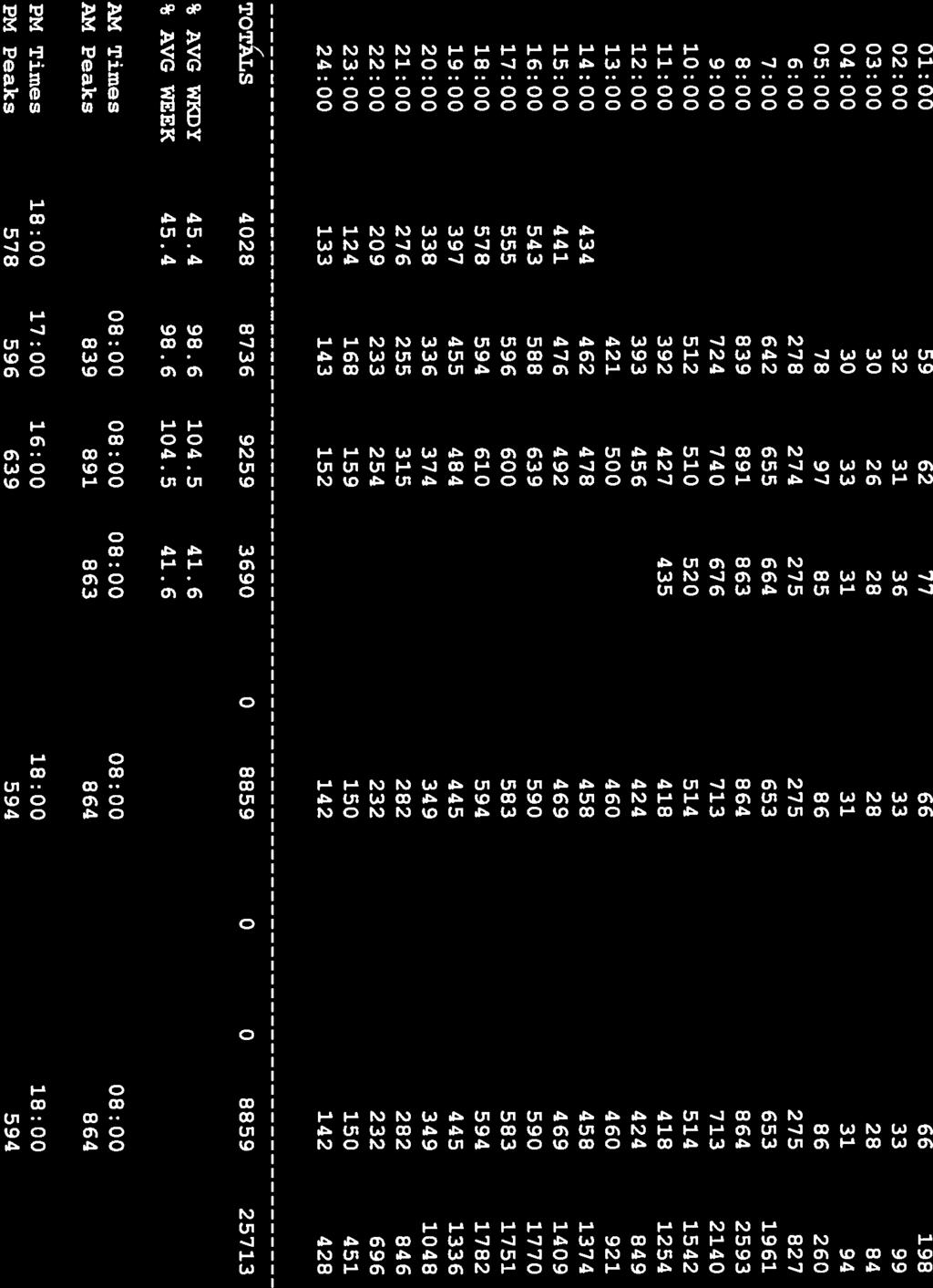
7 Town of Milton 7 March 1, 212 INTERSECTION CAPACITY ANALYSIS MPO staff collected turning-movement counts at the intersection on June 7, 211. The data were recorded in 15-minute intervals for the peak traffic periods in the morning, from 7: to 9: AM, and in the evening, from 4: to 6: PM. The intersection had peak hours, which occurred between 7: and 8: AM and between 5: and 6: PM. There was observed pedestrian activity during both peak hours at this intersection 7 pedestrians and 16 pedestrians were observed during the AM and PM peak hours, respectively. The intersection had peak hours between 7:3 and 8:3 AM and between 5: and 6: PM. There were 31 and 11 pedestrians observed during the AM and PM peak hours, respectively. The peak hour traffic volumes are shown in Figure 3. Based on the turning-movement counts and the signal timings measured on the site, the intersection capacity was analyzed by using an intersection capacity analysis program, Synchro. 3 The intersections were both modeled as unsignalized intersections, with stop control at the Brush Hill Road intersection and yield control at the intersection. Tables 3 and 4 shows the AM and PM peak hour analyses, respectively, for the existing conditions and the two alternatives provided. TABLE 3 AM Peak Hour Intersection Capacity Analysis Existing Conditions Alternative 1 Approach Mvmt LOS Delay 1 V/C Q 2 LOS Delay 1 V/C Q 2 Neponset Valley Parkway at Neponset Valley Parkway NB LT A.. A.. Neponset Valley Parkway SB TR A..3 A..3 EB LR C C Neponset Valley Parkway at Neponset Valley Parkway NB TR F A..38 Neponset Valley Parkway EB LT A.. A WB LLTR A.1.41 D at NB LTR B B SB LTR B B EB LTR A A WB LTR A.1. A.1. 1 Delay in seconds per vehicle. Queue in feet. 3 Synchro Version 7 was used for these analyses. This software is developed and distributed by Trafficware Ltd. It can perform capacity analysis and traffic simulation (when combined with SimTraffic) for an individual intersection or a series of intersections.
8 (14)17 (23)15 (1)9 () 1() () xxx AM Peak Hour Volumes (xxx) PM Peak Hour Volumes BOSTON REGION MPO FIGURE 3 Peak Hour Traffic Volumes Safety and Operations Improvements at Selected Intersections
9 Town of Milton 9 March 1, 212 TABLE 4 PM Peak-Hour Intersection Capacity Analysis Existing Conditions Alternative 1 Approach Mvmt LOS Delay 1 V/C Q 2 LOS Delay 1 V/C Q 2 Neponset Valley Parkway at Neponset Valley Parkway NB LT A.1. A.1. Neponset Valley Parkway SB TR A..3 A..38 EB LR C C Neponset Valley Parkway at Neponset Valley Parkway NB TR F A..3 Neponset Valley Parkway EB LT A..1 A WB LLTR A.1.57 E at NB LTR B B SB LTR A..1 B..1 EB LTR A A WB LTR A A.. 1 Delay in seconds per vehicle. 2 Queue in feet. ALTERNATIVES To address the concerns about safety, two alternatives were developed to improve safety as well as traffic operations at both intersections. The two alternatives, described below, share common features. Alternative 1: Realignment of the and Intersections Alternative 1 contains modifications to both the and intersections, as shown in Figure 4. The intersection of and Neponset Valley Parkway is realigned to a traditional T intersection. The intersection is moved approximately 15 feet south of its current location. A Neponset Valley Parkway southbound right-turn lane is added to accommodate the right turns onto. A stop sign is provided on the realigned eastbound approach. Access to the existing parking area for the recreational trails is now provided via a new driveway, which uses the abandoned segment. This eliminates the problem of vehicles turning into the parking area from the roadway curve. The addition of crosswalks across Neponset Valley Parkway and are included in this alternative. The intersection at Neponset Valley Parkway and is also realigned to provide for increased sight distance for entering drivers. A left-turn lane is provided for the Neponset Valley Parkway left-turns onto. The intersection is stop-sign controlled, with the stop sign being placed onto the approach. This creates improved traffic flow through the intersection based on existing traffic volumes. The existing segment of Brush

10 Legend Pedestrian Crosswalk BOSTON REGION MPO FIGURE 4 Alternative 1: Realignment of Brush Hill Road and Safety and Operations Improvements at Selected Intersections
11 Town of Milton 11 March 1, 212 Hill Road between Neponset Valley Parkway and is one-way northbound. An estimate of the construction cost is approximately $1,, to $1,25,. Alternative 2: Roundabout at and Realignment of Alternative 2, the roundabout alternative, is shown in Figure 5. While the intersection is the same as in Alternative 1, this alternative provides a roundabout at the Milton Street intersection in place of the existing T intersection. This is a single-lane roundabout that would fit into the existing area between Neponset Valley Parkway,, and Brush Hill Road. As shown, it has an inscribed circle with a diameter of 13 feet, and is designed to accommodate large trucks. An estimate of the construction cost for this alternative is approximately $1,, to $1,5,. Conceptual Plan for Neponset Valley Parkway at The Town of Milton provided a conceptual plan for this intersection (see Appendix E). The conceptual plan of the intersection includes constructing a large delta island separating the approach and departure lanes of, and maintaining the southbound movement of Neponset Valley Parkway to on the existing roadway. This plan would either eliminate the northbound Neponset Valley Parkway left turns to or maintain the left turns onto at the existing problem location, on a sharp curve. In addition, the northbound left turn onto Neponset Valley Parkway would still be located near its current location, on a curve, which could limit sight distance for both southbound Neponset Valley Parkway traffic and left-turning vehicles. IMPROVEMENT RECOMMENDATIONS The above safety and operations analyses indicate that either of the two alternatives would improve the safety operations, as well as the traffic operations, at both intersections. Both of the alternatives are longer-term projects. However, in either alternative, the and intersections could be designed and constructed separately. Completing either alternative or intersection does not preclude the eventual construction of the other. Due to the existing geometry at the intersection, there are no short-term improvements that can be recommended. At the intersection, consideration should be given to removing the existing yield sign on Neponset Valley Parkway northbound and placing a stop sign on the approach. Based on the traffic volumes, traffic flow through the intersection would be improved. In addition to the signing changes, Neponset Valley Parkway southbound at the intersection should be restriped to two-lanes: one exclusive leftturn lane and one through lane. The estimated cost is approximately $5,. MA/SA/EP/ma


12 Legend Pedestrian Crosswalk Yield Line BOSTON REGION MPO FIGURE 5 Alternative 2: Roundabout at and Realignment of Safety and Operations Improvements at Selected Intersections
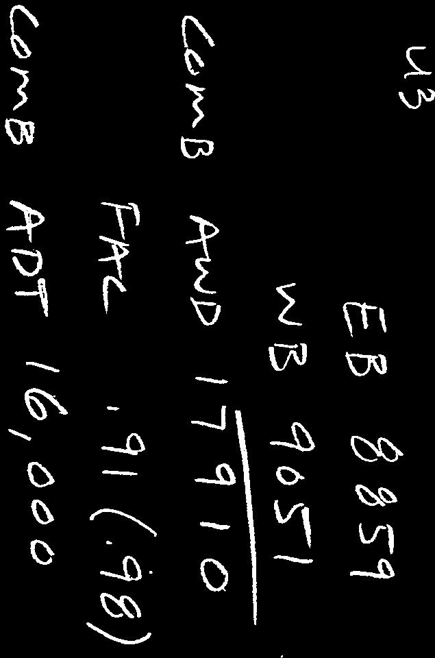
13 APPENDIX A Calculation of Crash Rates for: Neponset Valley Parkway at and Neponset Valley Parkway at
14 INTERSECTION CRASH RATE WORKSHEET CITY/TOWN : Milton COUNT DATE : 6/7/211 DISTRICT : 6 UNSIGNALIZED : X SIGNALIZED : ~ INTERSECTION DATA ~ MAJOR STREET : MINOR STREET(S) : Neponset Valley Parkway INTERSECTION DIAGRAM (Label Approaches) North Neponset Valley Parkway Neponset Valley Parkway APPROACH : DIRECTION : PEAK HOURLY VOLUMES (AM/PM) : " K " FACTOR : TOTAL # OF CRASHES : PEAK HOUR VOLUMES NB SB EB WB ,19 INTERSECTION ADT ( V ) = TOTAL DAILY.97 11,433 APPROACH VOLUME : 23 # OF YEARS : 3 AVERAGE # OF CRASHES PER YEAR ( A ) : Total Peak Hourly Approach Volume 7.67 CRASH RATE CALCULATION : RATE = ( A * 1,, ) ( V * 365 ) Comments : MassDOT District 3 Average Rate =.57 (July 7, 211) Project Title & Date: Safety and Operations Analyses at Selected Intersections
 North Neponset Valley Parkway Neponset Valley Parkway APPROACH : DIRECTION : PEAK HOURLY VOLUMES (AM/PM) : \" K \" FACTOR : TOTAL # OF CRASHES : PEAK HOUR")
15 INTERSECTION CRASH RATE WORKSHEET CITY/TOWN : Milton COUNT DATE : 6/7/211 DISTRICT : 6 UNSIGNALIZED : X SIGNALIZED : ~ INTERSECTION DATA ~ MAJOR STREET : MINOR STREET(S) : Neponset Valley Parkway INTERSECTION DIAGRAM (Label Approaches) North Neponset Valley Parkway Neponset Valley Parkway APPROACH : DIRECTION : PEAK HOURLY VOLUMES (AM/PM) : " K " FACTOR : TOTAL # OF CRASHES : PEAK HOUR VOLUMES NB SB EB WB ,495 INTERSECTION ADT ( V ) = TOTAL DAILY.97 15,412 APPROACH VOLUME : 6 # OF YEARS : 3 AVERAGE # OF CRASHES PER YEAR ( A ) : Total Peak Hourly Approach Volume 2. CRASH RATE CALCULATION :.356 RATE = ( A * 1,, ) ( V * 365 ) Comments : MassDOT District 3 Average Rate =.57 (July 7, 211) Project Title & Date: Safety and Operations Analyses at Selected Intersections
16 APPENDIX B Average Daily Traffic (ADT) of the Study Area Roadways

17 Google Map Data N Locations 1 to 5 in Milton


18

19


20


21

22


23

24

25


26
27
28 APPENDIX C Turning-Movement Counts (TMCs) for the Study Area Roadways
29 Central Transportation Planning Staff Neponset Valley TMC June 7, 211 AM: 7:-9: PM: 16:-18: File Name : Milton_Nepons_Milton_PM Site Code : Start Date : 6/7/211 Page No : 1 Groups Printed- Vehicles - Heavy Vehicles From East Neponset Valley Pkwy From South Neponset Valley Pkwy From West Start Time Right Thru Left App. Total Right Thru Left App. Total Right Thru Left App. Total Int. Total 16: : : : Total : : : : Total Grand Total Apprch % Total % Vehicles % Vehicles Heavy Vehicles % Heavy Vehicles From East Neponset Valley Pkwy From South Neponset Valley Pkwy From West Start Time Right Thru Left App. Total Right Thru Left App. Total Right Thru Left App. Total Int. Total Peak Hour Analysis From 16: to 17:45 - Peak 1 of 1 Peak Hour for Entire Intersection Begins at 17: 17: : : : Total Volume % App. Total PHF Vehicles % Vehicles Heavy Vehicles % Heavy Vehicles
30 Central Transportation Planning Staff Neponset Valley TMC June 7, 211 AM: 7:-9: PM: 16:-18: No Approach Out In Total File Name : Milton_Nepons_Milton_PM Site Code : Start Date : 6/7/211 Page No : 2 Peak Hour Data Neponset Valley Pkwy Out In Total Left Thru Right North Peak Hour Begins at 17: Vehicles Heavy Vehicles Right Thru Left Out In Total Left 1 1 Thru Right Out In Total Neponset Valley Pkwy
31 Pedestrians are by crossing approach Bicycles are by movement Central Transportation Planning Staff Neponset Valley TMC June 7, 211 AM: 7:-9: PM: 16:-18: File Name : Milton_Nepons_Milton_PM Site Code : Start Date : 6/7/211 Page No : 3 Groups Printed- Bicycles and Pedestrians From East Neponset Valley Pkwy From South Neponset Valley Pkwy From West Start Time Right Thru Left Peds App. Total Right Thru Left Peds App. Total Right Thru Left Peds App. Total Int. Total 16: : : :45 Total : : : : Total Grand Total Apprch % Total %
32 Central Transportation Planning Staff Neponset Valley TMC June 7, 211 AM: 7:-9: PM: 16:-18: File Name : Milton_Nepons_Milton_AM Site Code : Start Date : 6/7/211 Page No : 1 Groups Printed- Vehicles - Heavy Vehicles From East Neponset Valley Pkwy From South Neponset Valley Pkwy From West Start Time Right Thru Left App. Total Right Thru Left App. Total Right Thru Left App. Total Int. Total 7: : : : Total : : : : Total Grand Total Apprch % Total % Vehicles % Vehicles Heavy Vehicles % Heavy Vehicles From East Neponset Valley Pkwy From South Neponset Valley Pkwy From West Start Time Right Thru Left App. Total Right Thru Left App. Total Right Thru Left App. Total Int. Total Peak Hour Analysis From 7: to 8:45 - Peak 1 of 1 Peak Hour for Entire Intersection Begins at 7:3 7: : : : Total Volume % App. Total PHF Vehicles % Vehicles Heavy Vehicles % Heavy Vehicles
33 Central Transportation Planning Staff Neponset Valley TMC June 7, 211 AM: 7:-9: PM: 16:-18: No Approach Out In Total File Name : Milton_Nepons_Milton_AM Site Code : Start Date : 6/7/211 Page No : 2 Peak Hour Data Neponset Valley Pkwy Out In Total Left Thru Right North Peak Hour Begins at 7:3 Vehicles Heavy Vehicles Right Thru Left Out In Total Left Thru Right Out In Total Neponset Valley Pkwy
34 Pedestrians are by crossing approach Bicycles are by movement Central Transportation Planning Staff Neponset Valley TMC June 7, 211 AM: 7:-9: PM: 16:-18: File Name : Milton_Nepons_Milton_AM Site Code : Start Date : 6/7/211 Page No : 3 Groups Printed- Bicycles and Pedestrians From East Neponset Valley Pkwy From South Neponset Valley Pkwy From West Start Time Right Thru Left Peds App. Total Right Thru Left Peds App. Total Right Thru Left Peds App. Total Int. Total 7: 7: : : Total : : : : Total Grand Total Apprch % Total %
35 Central Transportation Planning Staff Neponset Valley TMC June 7, 211 AM: 7:-9: PM: 16:-18: File Name : Milton_Nepons_BrushHill_PM Site Code : Start Date : 6/7/211 Page No : 1 Groups Printed- Vehicles - Heavy Vehicles Neponset/Brush Hill From North Nepsonset From East From South Start Time Right (to parking) Thru Left App. Total Right Thru (to parking) Left App. Total Right Thru Left (to parking) App. Total Int. Total 16: : : : Total : : : : Total Grand Total Apprch % Total % Vehicles % Vehicles Heavy Vehicles % Heavy Vehicles Neponset/Brush Hill From North Nepsonset From East From South Start Time Right (to parking) Thru Left App. Total Right Thru (to parking) Left App. Total Right Thru Left (to parking) App. Total Int. Total Peak Hour Analysis From 16: to 17:45 - Peak 1 of 1 Peak Hour for Entire Intersection Begins at 17: 17: : : : Total Volume % App. Total PHF Vehicles % Vehicles Heavy Vehicles % Heavy Vehicles
36 Central Transportation Planning Staff Neponset Valley TMC June 7, 211 AM: 7:-9: PM: 16:-18: Neponset/Brush Hill Out In Total File Name : Milton_Nepons_BrushHill_PM Site Code : Start Date : 6/7/211 Page No : Right Thru (to parking) Left Peak Hour Data Parking Lot Out In Total North Peak Hour Begins at 17: Vehicles Heavy Vehicles Right parking) Thru (to Left Out In Total Nepsonset Left (to parking) Thru Right Out In Total
37 Pedestrians are by crossing approach Bicycles are by movement Central Transportation Planning Staff Neponset Valley TMC June 7, 211 AM: 7:-9: PM: 16:-18: File Name : Milton_Nepons_BrushHill_PM Site Code : Start Date : 6/7/211 Page No : 3 Groups Printed- Bicycles and Pedestrians Neponset/Brush Hill From North Nepsonset From East From South Start Time Right (to parking) Thru Left Peds App. Total Right Thru (to parking) Left Peds App. Total Right Thru Left (to parking) Peds App. Total Int. Total 16: : : :45 Total : : : : Total Grand Total Apprch % Total %
38 Central Transportation Planning Staff Neponset Valley TMC June 7, 211 AM: 7:-9: PM: 16:-18: File Name : milton_nepons_brushhill_am Site Code : Start Date : 6/7/211 Page No : 1 Groups Printed- Vehicles - Heavy Vehicles Neponset/Brush Hill From North Neponset From East From South Start Time Right (to parking) Thru Left App. Total Right Thru (to parking) Left App. Total Right Thru Left (to parking) App. Total Int. Total 7: : : : Total : : : : Total Grand Total Apprch % Total % Vehicles % Vehicles Heavy Vehicles % Heavy Vehicles Neponset/Brush Hill From North Neponset From East From South Start Time Right (to parking) Thru Left App. Total Right Thru (to parking) Left App. Total Right Thru Left (to parking) App. Total Int. Total Peak Hour Analysis From 7: to 8:45 - Peak 1 of 1 Peak Hour for Entire Intersection Begins at 7: 7: : : : Total Volume % App. Total PHF Vehicles % Vehicles Heavy Vehicles % Heavy Vehicles
39 Central Transportation Planning Staff Neponset Valley TMC June 7, 211 AM: 7:-9: PM: 16:-18: Neponset/Brush Hill Out In Total File Name : milton_nepons_brushhill_am Site Code : Start Date : 6/7/211 Page No : Right Thru (to parking) Left Peak Hour Data Parking Lot Out In Total North Peak Hour Begins at 7: Vehicles Heavy Vehicles Right parking) Thru (to Left Out In Total Neponset Left (to parking) Thru Right Out In Total
40 Pedestrians are by crossing approach Bicycles are by movement Central Transportation Planning Staff Neponset Valley TMC June 7, 211 AM: 7:-9: PM: 16:-18: File Name : milton_nepons_brushhill_am Site Code : Start Date : 6/7/211 Page No : 3 Groups Printed- Bicycles and Pedestrians Neponset/Brush Hill From North Neponset From East From South Start Time Right (to parking) Thru Left Peds App. Total Right Thru (to parking) Left Peds App. Total Right Thru Left (to parking) Peds App. Total Int. Total 7: : : :45 Total : : :3 8: Total Grand Total Apprch % Total %
41 Central Transportation Planning Staff TMC June 7, 211 AM: 7:-9: PM: 16:-18: File Name : Milton_BrushHill_Milton_PM Site Code : Start Date : 6/7/211 Page No : 1 Groups Printed- Vehicles - Heavy Vehicles From North From East From South From West Start Time Right Thru Left App. Total Right Thru Left App. Total Right Thru Left App. Total Right Thru Left App. Total Int. Total 16: : : : Total : : : : Total Grand Total Apprch % Total % Vehicles % Vehicles Heavy Vehicles % Heavy Vehicles From North From East From South From West Start Time Right Thru Left App. Total Right Thru Left App. Total Right Thru Left App. Total Right Thru Left App. Total Int. Total Peak Hour Analysis From 16: to 17:45 - Peak 1 of 1 Peak Hour for Entire Intersection Begins at 16:45 16: : : : Total Volume % App. Total PHF Vehicles % Vehicles Heavy Vehicles % Heavy Vehicles
42 Central Transportation Planning Staff TMC June 7, 211 AM: 7:-9: PM: 16:-18: Out In Total File Name : Milton_BrushHill_Milton_PM Site Code : Start Date : 6/7/211 Page No : 2 Right Thru Left Peak Hour Data Out In Total Left 29 Thru Right North Peak Hour Begins at 16:45 Vehicles Heavy Vehicles Right Thru Left Out In Total Left Thru Right Out In Total
43 Pedestrians are by crossing approach Bicycles are by movement Central Transportation Planning Staff TMC June 7, 211 AM: 7:-9: PM: 16:-18: File Name : Milton_BrushHill_Milton_PM Site Code : Start Date : 6/7/211 Page No : 3 From North Groups Printed- Bicycles and Pedestrians From East From South From West Start Time Right Thru Left Peds App. Total Right Thru Left Peds App. Total Right Thru Left Peds App. Total Right Thru Left Peds App. Total Int. Total 16: : :3 16:45 Total : 17:15 17: : Total Grand Total Apprch % Total %
44 Central Transportation Planning Staff TMC June 7, 211 AM: 7:-9: PM: 16:-18: File Name : Milton_BrushHill_Milton_AM Site Code : Start Date : 6/7/211 Page No : 1 Groups Printed- Vehicles - Heavy Vehicles From North From East From South From West Start Time Right Thru Left App. Total Right Thru Left App. Total Right Thru Left App. Total Right Thru Left App. Total Int. Total 7: : : : Total : : : : Total Grand Total Apprch % Total % Vehicles % Vehicles Heavy Vehicles % Heavy Vehicles From North From East From South From West Start Time Right Thru Left App. Total Right Thru Left App. Total Right Thru Left App. Total Right Thru Left App. Total Int. Total Peak Hour Analysis From 7: to 8:45 - Peak 1 of 1 Peak Hour for Entire Intersection Begins at 7:15 7: : : : Total Volume % App. Total PHF Vehicles % Vehicles Heavy Vehicles % Heavy Vehicles
45 Central Transportation Planning Staff TMC June 7, 211 AM: 7:-9: PM: 16:-18: Out In Total File Name : Milton_BrushHill_Milton_AM Site Code : Start Date : 6/7/211 Page No : 2 Right 1 1 Thru Left Peak Hour Data Out In Total Left 15 Thru 1 1 Right North Peak Hour Begins at 7:15 Vehicles Heavy Vehicles Right Thru Left Out In Total Left Thru Right Out In Total
46 Pedestrians are by crossing approach Bicycles are by movement Central Transportation Planning Staff TMC June 7, 211 AM: 7:-9: PM: 16:-18: File Name : Milton_BrushHill_Milton_AM Site Code : Start Date : 6/7/211 Page No : 3 From North Groups Printed- Bicycles and Pedestrians From East From South From West Start Time Right Thru Left Peds App. Total Right Thru Left Peds App. Total Right Thru Left Peds App. Total Right Thru Left Peds App. Total Int. Total 7: 7: : :45 Total : 8: : :45 Total Grand Total Apprch % Total %
47 APPENDIX D MassDOT Project Implementation Process
48 MassDOT Project Implementation Process The following description of the implementation process is based on Chapter 2 of the MassDOT Highway Division s Project Development and Design Guide (25). The text below borrows heavily from that document. 1 NEEDS IDENTIFICATION For each of the locations at which an improvement is to be implemented, the MassDOT Highway Division leads an effort to define the problem, establishes project goals and objectives, and defines the scope of the planning needed for implementation. To that end, it has to complete a Project Need Form (PNF), which states in general terms the deficiencies or needs related to the transportation facility or location. The PNF documents the problems and explains why corrective action is needed. For this study, the information defining the need for the project will be drawn primarily, perhaps exclusively, from the present report. Also, at this point in the process, the MassDOT Highway Division meets with potential participants, such as the Boston Region Metropolitan Planning Organization (MPO) and community members, to allow for an informal review of the project. The PNF is reviewed by the MassDOT Highway Division district office whose jurisdiction includes the location of the proposed project. The MassDOT Highway Division also sends the PNF to the MPO, for informational purposes. The outcome of this step determines whether the project requires further planning, whether it is already well supported by prior planning studies, and, therefore, whether it is ready to move forward into the design phase, or whether it should be dismissed from further consideration. 2 PLANNING This phase will likely not be required for the implementation of the improvements proposed in this planning study, as this planning report should constitute the outcome of this step. However, in general, the purpose of this implementation step is for the project proponent to identify issues, impacts, and approvals that may need to be obtained, so that the subsequent design and permitting processes are understood. The level of planning needed will vary widely, based on the complexity of the project. Typical tasks include: define the existing context, confirm project need, establish goals and objectives, initiate public outreach, define the project, collect data, develop and analyze alternatives, make recommendations, and provide documentation. Likely outcomes include consensus on the project definition to enable it to move forward into environmental documentation (if needed) and design, or a recommendation to delay the project or dismiss it from further consideration. 3 PROJECT INITIATION At this point in the process, the proponent, the MassDOT Highway Division, fills out, for each improvement, a Project Initiation Form (PIF), which is reviewed by its Project Review Committee (PRC) and the MPO. The PRC is composed of the Chief Engineer, each District Highway Director, and representatives of the Project Management, Environmental, Planning, Right-of-Way, Traffic,
49 and Bridge departments, and the Capital Expenditure Program Office (CEPO). The PIF documents the project type and description, summarizes the project planning process, identifies likely funding and project management responsibility, and defines a plan for interagency and public participation. First the PRC reviews and evaluates the proposed project based on MassDOT s statewide priorities and criteria. If the result is positive, the MassDOT Highway Division moves the project forward to the design phase, and to programming review by the MPO. The PRC may provide a Project Management Plan to define roles and responsibilities for subsequent steps. The MPO review includes project evaluation based on the MPO s regional priorities and criteria. The MPO may assign a project evaluation criteria score, a Transportation Improvement Program (TIP) year, a tentative project category, and a tentative funding category. 4 ENVIRONMENTAL, DESIGN, AND RIGHT-OF-WAY PROCESS This step has four distinct but closely integrated elements: public outreach, environmental documentation and permitting (if required), design, and right-of-way acquisition (if required). The outcome of this step is a fully designed and permitted project ready for construction. However, a project does not have to be fully designed in order for the MPO to program it in the TIP. 5 PROGRAMMING Programming, which typically begins during the design phase, can actually occur at any time during the process, from planning to design. In this step, which is distinct from project initiation, where the MPO receives preliminary information on the proposed project, the proponent requests that the MPO place the project in the region s TIP. The MPO considers the project in terms of regional needs, evaluation criteria, and compliance with the Long-Range Transportation Plan and decides whether to place it in the draft TIP for public review and then in the final TIP. 6 PROCUREMENT Following project design and programming, the MassDOT Highway Division publishes a request for proposals. It then reviews the bids and awards the contract to the qualified bidder with the lowest bid. 7 CONSTRUCTION After a construction contract is awarded, the MassDOT Highway Division and the contractor develop a public participation plan and a management plan for the construction process. 8 PROJECT ASSESSMENT The purpose of this step is to receive constituents comments on the project development process and the project s design elements. The MassDOT Highway Division can apply what is learned in this process to future projects.
50 APPENDIX E Town of Milton s Conceptual Plan for: Neponset Valley Parkway at

51
CENTRAL TRANSPORTATION PLANNING STAFF MEMORANDUM
 CTPS CENTRAL TRANSPORTATION PLANNING STAFF Staff to the Boston Region Metropolitan Planning Organization MEMORANDUM To: Martha White, Natick Town Administrator February 17, 2011 Eric Nascimento, MassDOT
TRAFFIC IMPACT STUDY
 TRAFFIC IMPACT STUDY for the GLEN ELLEN COUNTRY CLUB SENIOR RESIDENTIAL REDEVELOPMENT 84 Millis, Massachusetts Prepared by: McMahon Associates, Inc. Prepared for: Toll Brothers, Inc. August 216 DRAFT
MEMORANDUM. Layout Of Study Intersections And Traffic Control
 BOSTON REGION METROPOLITAN PLANNING ORGANIZATION Richard A. Davey, MassDOT Secretary and CEO and MPO Chairman Karl H. Quackenbush, Executive Director, MPO Staff DATE November 15, 2012 TO FROM RE Town of
Route 28 (South Orleans Road)/Route 39 (Harwich Road)/Quanset Road Intersection
/Route 39 (Harwich Road)/Quanset Road Intersection") TRAFFIC FEASIBILITY STUDY Route 28 (South Orleans Road)/Route 39 (Harwich Road)/Quanset Road Intersection Orleans, Massachusetts Prepared for: Town of Orleans Prepared by: Fay, Spofford & Thorndike, LLC
TRAFFIC FEASIBILITY STUDY Route 28 (South Orleans Road)/Route 39 (Harwich Road)/Quanset Road Intersection Orleans, Massachusetts Prepared for: Town of Orleans Prepared by: Fay, Spofford & Thorndike, LLC
BOSTON REGION METROPOLITAN PLANNING ORGANIZATION
 PLANNING ORGANIZATIO BOSTON REGION MPO NMETROPOLITAN BOSTON REGION METROPOLITAN PLANNING ORGANIZATION Stephanie Pollack, MassDOT Secretary and CEO and MPO Chair Karl H. Quackenbush, Executive Director,
Evaluation of M-99 (Broad Street) Road Diet and Intersection Operational Investigation
 Road Diet and Intersection Operational Investigation") Evaluation of M-99 (Broad Street) Road Diet and Intersection Operational Investigation City of Hillsdale, Hillsdale County, Michigan June 16, 2016 Final Report Prepared for City of Hillsdale 97 North Broad
Evaluation of M-99 (Broad Street) Road Diet and Intersection Operational Investigation City of Hillsdale, Hillsdale County, Michigan June 16, 2016 Final Report Prepared for City of Hillsdale 97 North Broad
Traffic Impact Analysis Walton Acres at Riverwood Athletic Club Clayton, NC
 Traffic Impact Analysis Walton Acres at Riverwood Athletic Club Clayton, NC 1. TABLE OF CONTENTS INTRODUCTION...1 1.1. Site Location and Study Area...1 1.2. Proposed Land Use and Site Access...2 1.3.
TRANSPORTATION ANALYSIS REPORT US Route 6 Huron, Erie County, Ohio
 TRANSPORTATION ANALYSIS REPORT US Route 6 Huron, Erie County, Ohio December 12, 2012 Prepared for: The City of Huron 417 Main Huron, OH 44839 Providing Practical Experience Technical Excellence and Client
December 4, Merrimac Zoning Board of Appeals 2-8 School Street Merrimac, MA Attn: Kathy Marshall. Dear Board Members:
 December 4, 28 Merrimac Zoning Board of Appeals 2-8 School Street Merrimac, MA 86 Attn: Kathy Marshall RE: RAMSHEAD MERRIMAC, MA Dear Board Members: Bayside Engineering, Inc. has received the MDM Transportation
HILTON GARDEN INN HOTEL HOTEL EXPANSION 2400 ALERT ROAD, OTTAWA TRANSPORTATION BRIEF. Prepared for:
 HILTON GARDEN INN HOTEL HOTEL EXPANSION 2400 ALERT ROAD, OTTAWA TRANSPORTATION BRIEF Prepared for: Bona Building & Management Co. Ltd. Place Vanier, 333 North River Road Vanier, Ontario K1L 8B9 October
Traffic Impact Study WestBranch Residential Development Davidson, NC March 2016
 Traffic Impact Study WestBranch Residential Development Davidson, NC March 216 TRAFFIC IMPACT STUDY FOR THE WestBranch Residential Development LOCATED IN DAVIDSON, NC Prepared For: Lennar Carolinas, LLC
TRAFFIC IMPACT ANALYSIS
 TRAFFIC IMPACT ANALYSIS FOR THE CHAMPAIGN UNIT#4 SCHOOL DISTRICT PROPOSED HIGH SCHOOL (SPALDING PARK SITE) IN THE CITY OF CHAMPAIGN Final Report Champaign Urbana Urbanized Area Transportation Study 6/24/2014
Troutbeck Farm Development
 Troutbeck Farm Development Willistown Township, Chester County PA For Submission To: Willistown Township Last Revised: October, 4 TPD# INLM.A. 5 E. High Street Suite 65 Pottstown, PA 9464 6.36.3 TPD@TrafficPD.com
CENTRAL TRANSPORTATION PLANNING STAFF MEMORANDUM
 CTPS CENTRAL TRANSPORTATION PLANNING STAFF Staff to the Boston Region Metropolitan Planning Organization MEMORANDUM To: Thomas Cummings February 17, 2011 Holbrook Public Works Superintendent From: Re:
FAIRFIELD INN & SUITES HOTEL 135 THAD JOHNSON PRIVATE OTTAWA TRANSPORTATION BRIEF. Prepared for:
 FAIRFIELD INN & SUITES HOTEL 135 THAD JOHNSON PRIVATE OTTAWA TRANSPORTATION BRIEF Prepared for: Bona Building & Management Co. Ltd. Place Vanier, 333 North River Road Vanier, Ontario K1L 8B9 August 12,
Capital Region Council of Governments
 March 23, 2018 Capital Region Council of Governments PROJECT CONCEPT REPORT Realignment of Swamp and Northfield Road s approaches to Route 44 (Boston Turnpike) Town of Coventry SUMMARY: The Town of Coventry
TRAFFIC IMPACT STUDY And A TRAFFIC SIGNAL WARRANT ANALYSIS FOR A SENIOR LIVING AND APARTMENT DEVELOPMENT
 TRAFFIC IMPACT STUDY And A TRAFFIC SIGNAL WARRANT ANALYSIS FOR A SENIOR LIVING AND APARTMENT DEVELOPMENT DEERFIELD TOWNSHIP, WARREN COUNTY, OHIO Nantucket Circle and Montgomery Road () Prepared for: ODLE
INDUSTRIAL BUILDING 3009 HAWTHORNE ROAD CITY OF OTTAWA TRANSPORTATION OVERVIEW REVISED. Prepared for: Canada Inc.
 INDUSTRIAL BUILDING 3009 HAWTHORNE ROAD CITY OF OTTAWA TRANSPORTATION OVERVIEW REVISED Prepared for: 7849648 Canada Inc. Octiober 1, 2015 114-598 Overview_2.doc D. J. Halpenny & Associates Ltd. Consulting
OFFICE/RETAIL DEVELOPMENT 1625 BANK STREET OTTAWA, ONTARIO TRANSPORTATION BRIEF. Prepared for: Canada Inc.
 OFFICE/RETAIL DEVELOPMENT 1625 BANK STREET OTTAWA, ONTARIO TRANSPORTATION BRIEF Prepared for: 9402209 Canada Inc. December 15, 2015 115-625 Report_2.doc D. J. Halpenny & Associates Ltd. Consulting Transportation
Traffic Impact Analysis Chatham County Grocery Chatham County, NC
 Chatham County Grocery Chatham County, NC TABLE OF CONTENTS 1. INTRODUCTION... 1 1.1. Location and Study Area... 1 1.2. Proposed Land Use and Access... 2 1.3. Adjacent Land Uses... 2 1.4. Existing ways...
NEW YORK CENTRAL PARK SUBDIVISION BLAIS STREET/ST-PIERRE STREET EMBRUN, ONTARIO TRAFFIC IMPACT STUDY. Prepared for:
 NEW YORK CENTRAL PARK SUBDIVISION BLAIS STREET/ST-PIERRE STREET EMBRUN, ONTARIO TRAFFIC IMPACT STUDY Prepared for: Solidex Holdings Limited & Investissement Maurice Lemieux Investments Attn: Mr. Anthony
Traffic Study of Fuller Street, Cady Street, West Street and West Avenue. Final Report
 Traffic Study of Fuller Street, Cady Street, West Street and West Avenue Final Report July 2005 Prepared for: Town of Ludlow Prepared by: Pioneer Valley Planning Commission 26 Central Street West Springfield,
INDUSTRIAL BUILDING 1660 COMSTOCK ROAD CITY OF OTTAWA TRANSPORTATION OVERVIEW. Prepared for:
 INDUSTRIAL BUILDING 1660 COMSTOCK ROAD CITY OF OTTAWA TRANSPORTATION OVERVIEW Prepared for: Simluc Contractors Limited 2550 Blackwell Street, Ottawa K1B 5R1 October 18, 2013 113-584 Overview_1.doc D. J.
HOLIDAY INN HOTEL 235 KING EDWARD AVENUE CITY OF OTTAWA TRANSPORTATION BRIEF. Prepared for:
 HOLIDAY INN HOTEL 235 KING EDWARD AVENUE CITY OF OTTAWA TRANSPORTATION BRIEF Prepared for: Momentum Planning & Communications 1165 Greenlawn Crescent Ottawa, ON K1L 6C2 June 29, 2015 115-618 Brief_1.doc
Walmart (Store # ) 60 th Street North and Marion Road Sioux Falls, South Dakota
 60 th Street North and Marion Road Sioux Falls, South Dakota") Walmart (Store #4865-00) 60 th Street North and Marion Road Sioux Falls, South Dakota Prepared for: Wal-Mart Stores, Inc. Bentonville, Arkansas Prepared by: Kimley-Horn and Associates, Inc. ã2013 Kimley-Horn
Walmart (Store #4865-00) 60 th Street North and Marion Road Sioux Falls, South Dakota Prepared for: Wal-Mart Stores, Inc. Bentonville, Arkansas Prepared by: Kimley-Horn and Associates, Inc. ã2013 Kimley-Horn
Gateway Transportation Study
 Gateway Transportation Study Amherst, Massachusetts SUBMITTED TO University of Massachusetts Amherst Town of Amherst SUBMITTED BY Vanasse Hangen Brustlin, Inc. Watertown, Massachusetts March 213 Back of
DUNBOW ROAD FUNCTIONAL PLANNING
 DUNBOW ROAD FUNCTIONAL PLANNING Final Report August 3, 216 #31, 316 5th Avenue NE Calgary, AB T2A 6K4 Phone: 43.273.91 Fax: 43.273.344 wattconsultinggroup.com Dunbow Road Functional Planning Final Report
5858 N COLLEGE, LLC N College Avenue Traffic Impact Study
 5858 N COLLEGE, LLC nue Traffic Impact Study August 22, 2016 Contents Traffic Impact Study Page Preparer Qualifications... 1 Introduction... 2 Existing Roadway Conditions... 5 Existing Traffic Conditions...
2. Existing Conditions
 2. Existing Conditions The existing traffic and parking conditions on the site and the surrounding area were reviewed based on the study methodology in Section 1.2. 2.1 Existing Land Use The portion of
STILLWATER AVENUE CORRIDOR STUDY Old Town, Maine
 Draft Study STILLWATER AVENUE CORRIDOR STUDY Old Town, Maine SUBMITTED TO: BANGOR AREA COMPREHENSIVE TRANSPORTATION SYSTEM SUBMITTED BY: I MAY 23, 2017 DRAFT STILLWATER AVENUE STUDY FINAL REPORT Table
MEDICAL/OFFICE BUILDING 1637 BANK STREET OTTAWA, ONTARIO TRANSPORTATION OVERVIEW. Prepared for:
 MEDICAL/OFFICE BUILDING 1637 BANK STREET OTTAWA, ONTARIO TRANSPORTATION OVERVIEW Prepared for: 2434984 Ontario Inc. 13-5510 Canotek Road Ottawa, Ontario K1J 9J5 June 4, 2015 115-613 Report_2.doc D. J.
ORANGE COUNTY PUBLIC WORKS TRAFFIC INVESTIGATIONS
 ORANGE COUNTY PUBLIC WORKS TRAFFIC INVESTIGATIONS STAFF REPORT OF: January 6, 2019 SUPERVISORIAL DISTRICT: 5 SUBJECT: LOCATION: INVESTIGATOR: O Neill Drive at Roanoke Drive; Ladera Ranch; TB 922-E6 Clever
METHODOLOGY. Signalized Intersection Average Control Delay (sec/veh)
") Chapter 5 Traffic Analysis 5.1 SUMMARY US /West 6 th Street assumes a unique role in the Lawrence Douglas County transportation system. This principal arterial street currently conveys commuter traffic
Chapter 5 Traffic Analysis 5.1 SUMMARY US /West 6 th Street assumes a unique role in the Lawrence Douglas County transportation system. This principal arterial street currently conveys commuter traffic
Table of Contents FIGURES TABLES APPENDICES. Traffic Impact Study Hudson Street Parking Garage MC Project No.: A Table of Contents
 Traffic Impact Study Hudson Street Parking Garage MC Project No.: 151714A Table of Contents Table of Contents I. INTRODUCTION... 2 II. EXISTING CONDITIONS... 5 III. 215 EXISTING TRAFFIC CONDITIONS... 6
Route 28 West Chatham Roadway Improvements
 Functional Design Report Route 28 Chatham Roadway Improvements Project No. 606596 Prepared for Massachusetts Department of Transportation Town of Chatham, Massachusetts Prepared by Howard/Stein-Hudson
MEETING FACILITY 2901 GIBFORD DRIVE CITY OF OTTAWA TRANSPORTATION BRIEF. Prepared for: Holiday Inn Express 2881 Gibford Drive Ottawa, ON K1V 2L9
 MEETING FACILITY 2901 GIBFORD DRIVE CITY OF OTTAWA TRANSPORTATION BRIEF Prepared for: Holiday Inn Express 2881 Gibford Drive Ottawa, ON K1V 2L9 December 18, 2012 112-566 Brief_1.doc D. J. Halpenny & Associates
OTTAWA TRAIN YARDS PHASE 3 DEVELOPMENT CITY OF OTTAWA TRANSPORTATION IMPACT STUDY. Prepared for:
 OTTAWA TRAIN YARDS PHASE 3 DEVELOPMENT CITY OF OTTAWA TRANSPORTATION IMPACT STUDY Prepared for: The Ottawa Train Yards Inc. 223 Colonnade Road South, Suite 212 Nepean, Ontario K2E 7K3 January 17, 2012
Glenn Avenue Corridor Traffic Operational Evaluation
 Glenn Avenue Corridor Traffic Operational Evaluation PREPARED FOR: THE CITY OF AUBURN PREPARED BY: DECEMBER 2007 Glenn Avenue Corridor Study--Auburn, Alabama TABLE OF CONTENTS Introduction... 1 Background
Waterford Lakes Small Area Study
 Waterford Lakes Small Area Study Existing Traffic Conditions PREPARED FOR: ORANGE COUNTY PUBLIC WORKS DEPARTMENT TRAFFIC ENGINEERING DIVISION ORLANDO, FLORIDA PREPARED WITH: INWOOD CONSULTING ENGINEERS
Transportation Impact Study for Abington Terrace
 Transportation Impact Study for Abington Terrace Abington Township, Montgomery County, PA Sandy A. Koza, P.E., PTOE PA PE License Number PE059911 Prepared by McMahon Associates, Inc. 425 Commerce Drive,
FRONT RANGE CROSSINGS TRAFFIC IMPACT STUDY
 FRONT RANGE CROSSINGS TRAFFIC IMPACT STUDY Prepared for: City of Thornton And Colorado Department of Transportation Prepared by: 11 Blake Street, Suite 2 Denver, Colorado 822 Contact: Brian Bern, PE, PTOE
Cheyenne Metropolitan Planning Organization
 Dell Range Boulevard Corridor Study PHASE II SECTION 20 DRAFT Prepared for: Cheyenne Metropolitan Planning Organization November 20, 2015 (Section 20 is bordered by Powderhouse Road on the west, Storey
DIMARCO CANANDAIGUA PROPERTIES HOUSING PROJECT CANANDAIGUA, ONTARIO COUNTY, NEW YORK
 TRAFFIC IMPACT STUDY FOR THE DIMARCO CANANDAIGUA PROPERTIES HOUSING PROJECT CANANDAIGUA, ONTARIO COUNTY, NEW YORK MARCH 14, 2017 PREPARED FOR: 1950 Brighton Henrietta Town Line Rd Rochester, NY 14623 PREPARED
BELCHERTOWN. Intersection of Federal Steet (Route 9) and Bay Road MAY 2012
 and Bay Road MAY 2012") BELCHERTOWN Intersection of Federal Steet (Route 9) and Bay Road MAY 2012 Prepared Under the Direction of Pioneer Valley MPO By: Pioneer Valley Planning Commission 60 Congress Street Springfield 01104-3419
BELCHERTOWN Intersection of Federal Steet (Route 9) and Bay Road MAY 2012 Prepared Under the Direction of Pioneer Valley MPO By: Pioneer Valley Planning Commission 60 Congress Street Springfield 01104-3419
BOSTON REGION METROPOLITAN PLANNING ORGANIZATION
 PLANNING ORGANIZATIO BOSTON REGION MPO NMETROPOLITAN BOSTON REGION METROPOLITAN PLANNING ORGANIZATION Stephanie Pollack, MassDOT Secretary and CEO and MPO Chairman Karl H. Quackenbush, Executive Director,
Highway 111 Corridor Study
 Highway 111 Corridor Study June, 2009 LINCOLN CO. HWY 111 CORRIDOR STUDY Draft Study Tea, South Dakota Prepared for City of Tea Sioux Falls Metropolitan Planning Organization Prepared by HDR Engineering,
QUICKIE C STORE AND GAS BAR 1780 HERON ROAD OTTAWA, ONTARIO TRANSPORTATION BRIEF. Prepared for:
 QUICKIE C STORE AND GAS BAR 1780 HERON ROAD OTTAWA, ONTARIO TRANSPORTATION BRIEF Prepared for: Quickie Convenience Stores Larny Holdings Ltd. c/o PBC Group April 15, 2015 115-615 Report_1.doc D. J. Halpenny
The Cape Cod Five Cents Savings Bank
 TRAFFIC IMPACT AND ACCESS STUDY The Cape Cod Five Cents Savings Bank Hyannis, Massachusetts PREPARED FOR The Cape Cod Five Cents Savings Bank 19 West Road Orleans, Massachusetts 0263 PREPARED BY 1 Walnut
Roundabout Feasibility Memorandum
 Roundabout Feasibility Memorandum To From Gwen Pipkin Bill Howell Date June 18, 2013 Subject Roundabout Feasibility Study SR 29 PD&E Study From Oil Well Road to SR 82 Collier County, FL FPID 417540-1-22-01
FINAL DESIGN TRAFFIC TECHNICAL MEMORANDUM
 FINAL DESIGN TRAFFIC TECHNICAL MEMORANDUM July 2014 FINAL (SR 43) Project Development and Environment Study From State Road 60 (Adamo Drive) to I-4 (SR 400) Hillsborough County, Florida Work Program Item
1609 E. FRANKLIN STREET HOTEL TRAFFIC IMPACT STUDY EXECUTIVE SUMMARY
 1609 E. FRANKLIN STREET HOTEL TRAFFIC IMPACT STUDY EXECUTIVE SUMMARY Prepared for: The Town of Chapel Hill Public Works Department Traffic Engineering Division Prepared by: HNTB North Carolina, PC 343
Technical Memorandum TRAFFIC IMPACT STUDY. RIDLEY ROAD CONVENIENCE STORE Southampton County, VA. Prepared for: Mr. David Williams.
 Technical Memorandum TRFFIC IMPCT STUDY RIDLEY ROD CONVENIENCE STORE Southampton County, V Prepared for: Mr. David Williams By: Charles Smith, P.E., PTOE EPR Charlottesville, V July 2014 1 TBLE OF CONTENTS
Highway 49, Highway 351 and Highway 91 Improvements Feasibility Study Craighead County
 Highway 49, Highway 351 and Highway 91 Improvements Feasibility Study Craighead County Executive Summary March 2015 Highway 49, Highway 351 and Highway 91 Improvements Feasibility Study Craighead County
DRAFT. Corridor study. Honeysuckle Road. October Prepared for the City of Dothan, AL. Prepared by Gresham, Smith and Partners
 DRAFT Corridor study Honeysuckle Road October 2017 Prepared for the City of Dothan, AL Prepared by TABLE OF CONTENTS SECTION I... 1 STUDY SUMMARY... 1 INTRODUCTION... 1 CONCLUSIONS... 5 SECTION II... 7
REDEVELOPMENT TRAFFIC IMPACT STUDY
 REDEVELOPMENT TRAFFIC IMPACT STUDY For Wendy s Parker, Colorado January 215 Prepared for: Sterling Design Associates, LLC 29 W. Littleton Boulevard #3 Littleton, Colorado 812 Prepared by: 1233 Airport
APARTMENT BUILDING DEVELOPMENT 1161 HERON ROAD OTTAWA, ONTARIO TRANSPORTATION IMPACT STUDY. Prepared for:
 APARTMENT BUILDING DEVELOPMENT 1161 HERON ROAD OTTAWA, ONTARIO TRANSPORTATION IMPACT STUDY Prepared for: 1649362 Ontario Inc. c/o Manor Park Management 231 Brittany Drive, Suite D Ottawa ON K1K 0R8 July
BOSTON REGION METROPOLITAN PLANNING ORGANIZATION
 PLANNING ORGANIZATIO BOSTON REGION MPO NMETROPOLITAN BOSTON REGION METROPOLITAN PLANNING ORGANIZATION Richard A. Davey, MassDOT Secretary and CEO and MPO Chairman Karl H. Quackenbush, Executive Direcr,
THIS PAGE LEFT BLANK INTENTIONALLY
 GA SR 25 Spur at Canal Road Transportation Impact Analysis PREPARED FOR GLYNN COUNTY, GEORGIA 1725 Reynolds Street, Suite 300 Brunswick, Georgia 31520 PREPARED BY 217 Arrowhead Boulevard Suite 26 Jonesboro,
Traffic Impact and Access Study. The Preserve at Abbyville Proposed 40B Residential Development. Norfolk, Massachusetts
 Traffic Impact and Access Study The Preserve at Abbyville Proposed 40B Residential Development Norfolk, Massachusetts Prepared for DiPlacido Development Corp. April 2017 Prepared by GREEN INTERNATIONAL
Road Conversion Study Plumas Street
 Plumas Street Phase I Submitted to The Regional Transportation Commission of Washoe County Submitted by Zong Tian, Ph.D., P.E. Saeedeh Farivar Haiyuan Li, Ph.D. Center for Advanced Transportation Education
Draft Report. Traffic Impact Study. Superstore, Wal-Mart, and Kent Development. Yarmouth, Nova Scotia. Prepared for
 oad & Traffic Management Road & Traffic Management R Atlantic Traffic Engineering Specialists Draft Report Traffic Impact Study Superstore, Wal-Mart, and Kent Development Yarmouth, Nova Scotia Prepared
TRAFFIC ASSESSMENT River Edge Colorado
 TRAFFIC ASSESSMENT River Edge Colorado Submitted by: Fehr & Peers 621 17th Street, Ste. 231 Denver, CO 8293 (33) 296-43 December, 21 App. M-2 Traffic Assessment River Edge Colorado December 21 TABLE OF
Intersection Traffic Control Feasibility Study
 Intersection Traffic Control Feasibility Study CSAH 9 at CSAH 60 (185th Avenue) Prepared For: Dakota County Transportation Department Western Service Center 14955 Galaxie Avenue, 3rd Floor Apple Valley,
PINESTONE TRAFFIC IMPACT STUDY Travelers Rest, South Carolina
 PINESTONE TRAFFIC IMPACT STUDY Travelers Rest, South Carolina Prepared for Longbranch Development Prepared by January 13, 219 ii Table of Contents Subject Page Signature Page... i Table of Contents...
PEDESTRIAN SAFETY STUDY
 PEDESTRIAN SAFETY STUDY SR 699 (BLIND PASS RD/GULF BLVD) FROM 93 RD AVENUE TO PINELLAS BAYWAY PINELLAS COUNTY SECTION NO.: 15100 MILEPOST: 0.111 3.569 STUDY LIMITS Prepared For: Florida Department of Transportation
ORLEANS GARDENS SHOPPING CENTRE 1615 ORLEANS BOULEVARD CITY OF OTTAWA, ONTARIO TRANSPORTATION IMPACT STUDY. Prepared for:
 ORLEANS GARDENS SHOPPING CENTRE 1615 ORLEANS BOULEVARD CITY OF OTTAWA, ONTARIO TRANSPORTATION IMPACT STUDY Prepared for: Orleans Gardens Shopping Centre Inc. 2851 John Street, Suite 1 Markham, ON K3R 5R7
URBAN QUARRY HEADQUARTERS 2717 STEVENAGE DRIVE CITY OF OTTAWA TRANSPORTATION OVERVIEW. Prepared for: Urban Quarry 4123 Belgreen Drive, Ottawa K1G 3N2
 URBAN QUARRY HEADQUARTERS 2717 STEVENAGE DRIVE CITY OF OTTAWA TRANSPORTATION OVERVIEW Prepared for: Urban Quarry 4123 Belgreen Drive, Ottawa K1G 3N2 February 27, 2014 113-584 Overview_1.doc D. J. Halpenny
List of Attachments. Location Map... Site Plan... City of Lake Elsinore Circulation Element... City of Lake Elsinore Roadway Cross-Sections...
 List of Attachments Exhibits Location Map... Site Plan... City of Lake Elsinore Circulation Element... City of Lake Elsinore Roadway Cross-Sections... Existing Lane Geometry and Traffic Controls... Existing
133 rd Street and 132 nd /Hemlock Street 132 nd Street and Foster Street MINI ROUNDABOUTS. Overland Park, Kansas
 133 rd Street and 132 nd /Hemlock Street 132 nd Street and Foster Street MINI ROUNDABOUTS Overland Park, Kansas September 1, 2017 TABLE OF CONTENTS 1. INTRODUCTION... 1 2. LITERATURE REVIEW... 1 3. CONCEPT
EXISTING (2006) CONDITIONS
 CONDITIONS") Section 2 EXISTING (2006) CONDITIONS This section provides a description of the existing transportation system in the study area and a comprehensive analysis of existing traffic operations and crash history.
Section 2 EXISTING (2006) CONDITIONS This section provides a description of the existing transportation system in the study area and a comprehensive analysis of existing traffic operations and crash history.
Traffic Impact Study Little Egypt Road Development Denver, North Carolina June 2017
 Traffic Impact Study Little Egypt Road Development Denver, North arolina June 2017 N. Little Egypt Road DQ\ QDQFLQJ VDOHV RU RWKHU SHUIRUPDQFH EDVHG FULWHULD Proposed Site Driveways Site Driveway 1 TRAFFI
Albany Shaker Road Corridor Study Public Meeting # 2
 Albany Shaker Road Corridor Study Public Meeting # 2 Scope / Meeting Purpose This project is a CDTC Linkage Study. The Linkage Program is designed to implement the adopted planning and investment principles
Executive Summary Introduction Methodology...3 Level of Service (LOS) Analysis...4. Study Location... 5
 Analysis...4. Study Location... 5") The Delaware Valley Regional Planning Commission is dedicated to uniting the region s elected officials, planning professionals, and the public with a common vision of making a great region even greater.
The Delaware Valley Regional Planning Commission is dedicated to uniting the region s elected officials, planning professionals, and the public with a common vision of making a great region even greater.
Military Road Safety Improvements
 Military Road Safety Improvements 26 th Road North to 31 st Street North SUMMARY OF DATA REVIEW AND PRELIMINARY RECOMMENDATIONS Prepared for: Department of Environmental Services Traffic Engineering and
Truck Climbing Lane Traffic Justification Report
 ROUTE 7 (HARRY BYRD HIGHWAY) WESTBOUND FROM WEST MARKET STREET TO ROUTE 9 (CHARLES TOWN PIKE) Truck Climbing Lane Traffic Justification Report Project No. 6007-053-133, P 101 Ι UPC No. 58599 Prepared by:
MEMORANDUM. Our project study area included the following locations:
 MEMORANDUM Date: To: From: Subject: Najib O. Habesch Nick M. Fomenko, PE, PTOE Bushnell Park North Traffic Assessment BETA Project #: 4461 As part of our contract to undertake the design of the Bushnell
TRAFFIC IMPACT STUDY
 675 Millcreek Drive, Unit 1 Mississauga, Ontario L5N 5M4 T: 416.213.7121 F: 95.89.8499 www.transtech.co TRAFFIC IMPACT STUDY PROPOSED MOSQUE DEVELOPMENT 4269 REGIONAL ROAD 25 TOWN OF OAKVILLE PREPARED
Traffic Impact and Access Study PROPOSED DURKEE FARM ESTATES. Foster Street Littleton, Massachusetts. Prepared for: Grimes Road, LLC.
 Traffic Impact and Access Study PROPOSED DURKEE FARM ESTATES Foster Street Littleton, Massachusetts Prepared for: Grimes Road, LLC. Westford, MA Prepared by: MDM Transportation Consultants, Inc. 28 Lord
M-58 HIGHWAY ACCESS MANAGEMENT STUDY Mullen Road to Bel-Ray Boulevard. Prepared for CITY OF BELTON. May 2016
 M-58 HIGHWAY ACCESS MANAGEMENT STUDY Prepared for CITY OF BELTON By May 2016 Introduction Missouri State Highway 58 (M-58 Highway) is a major commercial corridor in the City of Belton. As development has
Donahue Drive Corridor Traffic Operational Evaluation
 Donahue Drive Corridor Traffic Operational Evaluation PREPARED FOR: THE CITY OF AUBURN PREPARED BY: JANUARY 2007 Donahue Drive Corridor Study--Auburn, Alabama TABLE OF CONTENTS Introduction... 1 Background
TRAFFIC STUDY GUIDELINES Clarksville Street Department
 TRAFFIC STUDY GUIDELINES Clarksville Street Department 9/1/2009 Introduction Traffic studies are used to help the city determine potential impacts to the operation of the surrounding roadway network. Two
CAPE COD COMMISSION 3225 MAIN STREET P.O. BOX 226 BARNSTABLE, MA (508) Fax (508) Transportation Safety Report
 Fax (508) Transportation Safety Report") CAPE COD COMMISSION 3225 MAIN STREET P.O. BOX 226 BARNSTABLE, MA 02630 (508) 362-3828 Fax (508) 362-3136 2006 Transportation Safety Report Bourne: Otis Rotary Harwich: Route 137/Route 39 Orleans: Route
CAPE COD COMMISSION 3225 MAIN STREET P.O. BOX 226 BARNSTABLE, MA 02630 (508) 362-3828 Fax (508) 362-3136 2006 Transportation Safety Report Bourne: Otis Rotary Harwich: Route 137/Route 39 Orleans: Route
I-95 Northbound at US 1 (Exit 126) Design and Study Final Report
 Design and Study Final Report") I-95 Northbound at US 1 (Exit 126) Design and Study Final Report July 2018 Prepared by: Prepared for: TABLE OF CONTENTS 1 Introduction... 1 Study Area Limits... 1 Purpose and Need of the Study... 1 Safety
I-95 Northbound at US 1 (Exit 126) Design and Study Final Report July 2018 Prepared by: Prepared for: TABLE OF CONTENTS 1 Introduction... 1 Study Area Limits... 1 Purpose and Need of the Study... 1 Safety
EXECUTIVE SUMMARY. Page 1 of 6
 EXECUTIVE SUMMARY The purpose of this report is to identify conformance with the original traffic impact study for the proposed retail development on Lot 5 of Riverdale Retail Filing No. 1 located on the
Edgemont Village Traffic and Parking Technical Report January 2014
 Edgemont Village Traffic and Parking Technical Report January 2014 In the fall of 2013, the District of North Vancouver engaged consultants to assess existing intersection and parking conditions in Edgemont
THE FUTURE OF THE TxDOT ROADWAY DESIGN MANUAL
 THE FUTURE OF THE TXDOT ROADWAY DESIGN MANUAL Kenneth Mora, P.E. (Design Division) 10/10/2017 Table of contents 1 2 Reduction in FHWA design controlling criteria Innovative Intersection Guidance 3-7 8-42
TRAFFIC CONTROL DEVICES ON EDGEWATER BOULEVARD AT PORT ROYAL AVENUE (NORTH)
") Attachment 2 DATE: August 6, 2012 TO: VIA: FROM: SUBJECT: Mayor and Members of the City Council James C. Hardy, City Manager Ramon Towne, Director of Public Works Leah Edwards, Assistant Engineer TRAFFIC
Attachment 2 DATE: August 6, 2012 TO: VIA: FROM: SUBJECT: Mayor and Members of the City Council James C. Hardy, City Manager Ramon Towne, Director of Public Works Leah Edwards, Assistant Engineer TRAFFIC
Draft North Industrial Area-Wide Traffic Plan
 Summary of North Industrial and Hudson Bay Industrial Recommended Improvements Table 1. Summary of s Item Location 1 2 3 4 5 6 7 8 9 10 11 12 Millar Ave north of 51st St Super 8 Motel back lane 400 Block
Harrah s Station Square Casino
 Transportation Analysis Harrah s Station Square Casino Pittsburgh, Pennsylvania Submitted To: City of Pittsburgh and Pennsylvania Gaming Control Board Prepared By: DKS Associates GAI Consultants December
BOSTON REGION METROPOLITAN PLANNING ORGANIZATION
 PLANNING ORGANIZATIO BOSTON REGION MPO NMETROPOLITAN BOSTON REGION METROPOLITAN PLANNING ORGANIZATION Stephanie Pollack, MassDOT Secretary and CEO and MPO Chairman Karl H. Quackenbush, Executive Director,
TZ Vista Traffic Impact Study
 TZ Vista Traffic Impact Study A. INTRODUCTION This Traffic Impact Study (TIS) provides a detailed analysis to assess the potential traffic and transportation impacts of the TZ Vista multi-family residential
Clay Street Realignment Project Traffic Study
 Final Clay Street Realignment Project Traffic Study November 24, 2009 Prepared for: City of Placerville RS07-2466 2990 Lava Ridge Court, Suite 200 Roseville, CA 95661 (916) 773-1900 Fax (916) 773-2015
City of Prince Albert Statement of POLICY and PROCEDURE. Department: Public Works Policy No. 66. Section: Transportation Issued: July 14, 2014
 Page: 1 of 8 1 POLICY 1.01 The City shall follow all of the specifications in the Manual of Uniform Traffic Control Devices for Canada, prepared by the National Committee of Uniform Traffic Control, and
Traffic Study North Shore School District 112
 Traffic Study North Shore School District 112 Proposed Expansion of Northwood Junior High School Prepared By: May 1, 2015 1. Introduction Kenig, Lindgren, O Hara, Aboona, Inc. (KLOA, Inc.) has been retained
ALLEY 24 TRAFFIC STUDY
 ALLEY 24 TRAFFIC STUDY in City of Frostburg, Maryland January 2013 3566 Teays Valley Road Hurricane, WV Office: (304) 397-5508 www.denniscorporation.com Alley 24 Traffic Study January 2013 Frostburg, Maryland
FORM A PASCO COUNTY ACCESS CONNECTION PERMIT APPLICATION
 FORM 901.3.A PASCO COUNTY ACCESS CONNECTION PERMIT APPLICATION The following information is required from all applicants directly or indirectly accessing any collector or arterial road or as otherwise
MEMORANDUM. Nantasket Road at Kingsley Road Kingsley Road at Sumner Street Kingsley Road at Revere Street Kingsley Road at Kenberma Street
 MEMORANDUM Date: June 28, 2012 To: From: Subject: Mr. Joseph Stigliani, Director of Public Works Kenneth J. Petraglia, P.E., PTOE Greg E. Lucas, P.E., PTOE Kingsley Road Stop Sign Warrant Analysis BETA
ROAD SAFETY AUDIT. Granite Avenue at Interstate 93 Ramps. Town of Milton. May 22, Prepared for: MassDOT
 ROAD SAFETY AUDIT Granite Avenue at Interstate 93 Ramps Town of Milton May 22, 2017 Prepared for: MassDOT Prepared by: Toole Design Group 2 Oliver Street, Suite 305 Boston, MA 02109 Table of Contents Background...
Enclosure 1. Crimson Drive Traffic Safety and Calming Review Report
 Enclosure 1 Crimson Drive Traffic Safety and Calming Review Report Prepared by: Tahir Hameed, P.Eng. Traffic Safety Engineer Planning Engineering and Safety Transportation Planning and Engineering Date:
PRELIMINARY DRAFT WADDLE ROAD / I-99 INTERCHANGE PROJECT ALTERNATIVE ANALYSIS FINAL TRAFFIC SUMMARY REPORT
 PRELIMINARY DRAFT WADDLE ROAD / I-99 INTERCHANGE PROJECT ALTERNATIVE ANALYSIS FINAL TRAFFIC SUMMARY REPORT Prepared by: In Association with: November 2013 EXECUTIVE SUMMARY Patton Township, in partnership