MAPUNGUBWE WORLD HERITAGE SITE NOMINATION. Department of Environmental Affairs & Tourism Republic of South Africa
|
|
|
- Rafe Hamilton
- 6 years ago
- Views:
Transcription


1 MAPUNGUBWE WORLD HERITAGE SITE NOMINATION Department of Environmental Affairs & Tourism Republic of South Africa
2
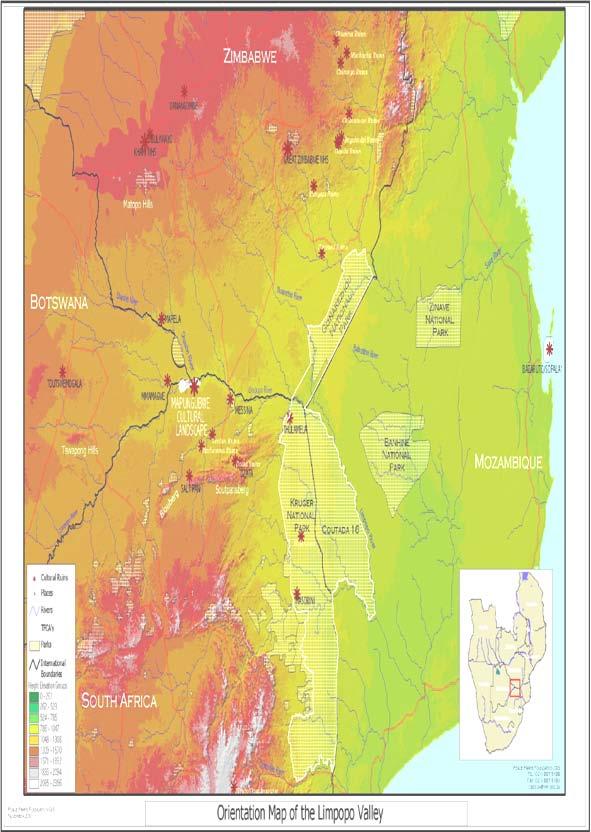
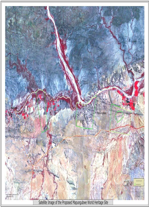
3 IDENTIFICATION OF THE PROPERTY Situated to the south of the confluence of the Limpopo and Shashe Rivers on the border of South Africa, Botswana and Zimbabwe The boundaries are the same as the Vhembe-Dongola National Park Size ha

4 Boundaries the same as the Vhembe- Dongola National Park
5 JUSTIFICATION FOR INSCRIPTION Mapungubwe is nominated in the category:- Cultural landscape it is illustrative of the evolution of human society and settlement over time, under the influence of the physical restraints and/or opportunities presented by the natural environment

6 The Limpopo River looking northeast from the Shashe confluence
7 SIGNIFICANCE OF MAPUNGUBWE The Mapungubwe Cultural Landscape was the centre of the first kingdom in Southern Africa, established by the cultural ancestors of the present-day Shona and Venda. It includes over 400 archaeological sites and the three successive capitals of Schroda, K2 and Mapungubwe, occupied between AD 900 and The dynamic interaction between society and landscape during this period laid the foundation for a new type of social organisation in southern Africa.
8 SIGNIFICANCE OF MAPUNGUBWE The kingdom grew as a result of two major factors: 1) wealth accumulated from trade in gold, glass beads, cotton cloth, Chinese and local ceramics, ivory, copper and hides within the Indian Ocean network; 2) ideal landscape and climatic conditions for agriculture that provided for a population of over 9000 people.
9 SIGNIFICANCE OF MAPUNGUBWE East coast trade was established at Schroda by AD 900. During the occupation of K2 wealth and power grew substantially. By the 13 th Century AD, a social hierarchy had developed. Mapungubwe Hill was occupied by the king and was modified to separate the elite from the commoners below. The onset of the Little Ice Age caused drought and crop failures. The kingdom dispersed after AD 1300, new social and political alliances were formed, and the centre of regional power shifted to Great Zimbabwe.

10 Schroda site, looking north towards the Limpopo

11 K2 Valley from Bambandyanalo Hill

12 Mapungubwe Hill from the south west
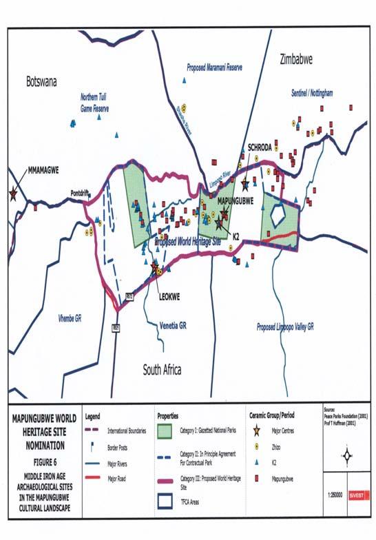
13 Zhizo/K2/Mapungubwe sites
14 Rock art sites
15 Khami/Venda/Icon sites
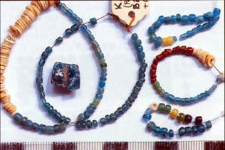
16 COMPARATIVE ANALYSIS The Mapungubwe Cultural Landscape is the cultural and historical precursor to two sites on the World Heritage List, namely Great Zimbabwe and Khami, both of which are in Zimbabwe. Great Zimbabwe is about 250 km to the north-east and Khami is about 220 km north-north-west of Mapungubwe.
17 AUTHENTICITY/INTEGRITY The remains of the design, material, workmanship and setting of individual sites, and the distinctive character and components of the Mapungubwe Cultural Landscape, are largely intact, despite the passage of between 700 and 1100 years.

18 The main approach to Mapungubwe Hill

19 Special interest group on top of Mapungubwe Hill
20 CRITERIA FOR NOMINATION The Mapungubwe Cultural Landscape.. (ii) exhibits an important interchange of human values on developments in technology and town planning (iii) bears a unique or at least exceptional testimony to a cultural tradition or to a civilization which has disappeared (iv) is an outstanding example of a landscape which illustrates a significant stage in human history (v) is an outstanding example of a traditional human settlement or land-use which is representative of a culture
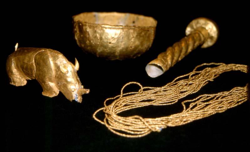
21 (ii) exhibits an important interchange of human values Trade with East African coastal communities in the Indian Ocean network brought Mapungubwe people into the global village and created wealth Accumulated wealth led to development of an elite class Class distinction led to a shift in town layout from the traditional central cattle pattern to a sacred leadership pattern, with the leader secluded on top of the hill away from the commoners. Interchange of values is recorded in rock art by hunter-gatherers and agriculturists
22 From Mapungubwe they traded into the Indian Ocean trade network
 found at Mapungubwe next to a whole")

23 Fragments of Chinese celadon from the Sung Dynasty ( AD) found at Mapungubwe next to a whole celadon wine kettle from China Trade beads from Mapungubwe (note the large garden roller beads and moulds at the back)


24 From Schroda TRADE BEADS From K2 From Mapungubwe


25 ROCK ART Polychrome giraffes Khoe herder with fattailed sheep An unusually high proportion of aprons & loincloths

26 An important San rock shelter

27 Interpretation board at Kaoxa Rock Shelter
28 (iii) bears a unique or at least exceptional testimony to a cultural tradition or to a civilization which has disappeared the first southern African kingdom the largest inland settlement at that time (>9000 people), with influence over km 2 early evidence of substantial gold working prior to European exploitation: thousands of gold beads and artworks including golden rhino, sceptre and bowl that followed a long tradition of baked clay figurines and pottery substantial evidence of trade in the Indian Ocean network, including glass beads from Iran, India, Indonesia and Egypt, and celadon from China


29 Clay figurines; and spindle whorl to make cotton cloth Decorated ivory arm band Beautiful ceramic pots from Royal burial sites on Mapungubwe Hill
30 Mapungubwe gold
31 (iv) an outstanding example of a landscape which illustrates a significant stage in human history the important components of the landscape that come together at Mapungubwe are:- Ideal climatic conditions and flooding from the Limpopo and Shashe rivers replenished the soil, allowing sufficient agricultural production to sustain a town of over 9000 people. Inaccessible sandstone outcrops were important for rainmaking, and the symbolic elevation of the elite. The top of Mapungubwe Hill was extensively modified by carrying in tons of soil to create a level platform for the houses and graves of the ruling elite. Anchor holes were drilled into the rock to stabilize the houses. The impact of homesteads and cattle kraals on the vegetation is still clearly visible at sites such as Leokwe and K2.
32


33 Main access to Mapungubwe Hill was via this narrow cleft Mapungubwe Period walling on the Southern Terrace


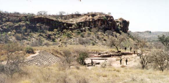
34 Gardner s excavations on top of Mapungubwe in note depth of soil Mapungubwe Hill before excavations in note rounded form on top, showing soil carried in by people
35 (v) an outstanding example of a traditional human settlement or land- use which is representative of a culture, that became vulnerable under the impact of irreversible change The Mapungubwe Cultural Landscape records the sequence of spatial changes that reflect the evolution of class distinction and sacred leadership in the settlements from Schroda to K2 and Mapungubwe. These are the only places in South Africa where exotic trade items have been found in such large quantities. The main phase of settlement coincides with a period of prolonged higher rainfall that ceased with the onset of the Little Ice Age after AD 1300 When agriculture could no longer sustain the large population, the power of the sacred leader declined, people moved away and Great Zimbabwe became the regional centre of power and trade
36


37 Excavation on the Southern Terrace, showing stone platform features Excavation on Mapungubwe Hill, showing hut floors and post holes


38 Copper musuku trade ingot from Samaria Pottery sherds and hut anchor holes on top of Mapungubwe Hill


39 Grinding scoops Board game
40 CONSERVATION STATUS The area is in the process of being proclaimed a National Park to protect both the natural biodiversity and the cultural landscape A Trans Frontier Conservation Area will include properties in South Africa, Botswana and Zimbabwe Proclamation as a National Heritage Site is under way
41 MANAGEMENT ISSUES Consultation with local communities and oral history project completed Land purchase in progress, with Peace Parks Foundation as key funders Three properties have so far been proclaimed as national park The Park Committee and Archaeological Task Group have been established The TFCA will be an effective buffer The Preliminary Park Management Plan is available Site rehabilitation with Poverty Alleviation Funding is in progress The Tourism Plan is due soon
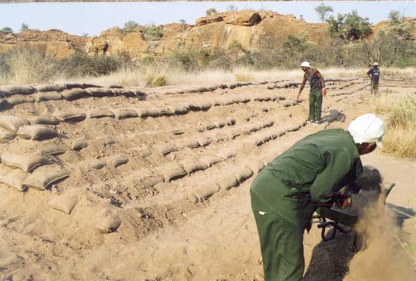
42 Site rehabilitation work


43 In November 2001 approval was given by the South African Heritage Resources Agency to declare the Mapungubwe Cultural Landscape as a National Heritage Site, under the new National Heritage Resources Act (No.25 of 1999)"

44 Young people rediscovering the rich cultural heritage of South Africa end
Grade 6 History Term 1
 1 Grade 6 History Term 1 KINGDOMS OF SOUTHERN AFRICA MAPUNGUBWE The city of Mapungubwe is in the Limpopo Province, on a farm called Greefswald, near the Limpopo River. Mapungubwe means Hill of the Jackal.
Rebuilding an ancient southern African kingdom
 Rebuilding an ancient southern African kingdom early 80 years of intensive collaborative multidisciplinary research on the Iron Age settlement complex of Mapungubwe, now a proclaimed world heritage site
CHAPTER EIGHT CONCLUSION
 CHAPTER EIGHT CONCLUSION Up until fairly recently, little was known about hunter-gatherers or interaction in the Shashe-Limpopo region, in contrast to the well-known Iron Age sequence. One goal of this
The geography of Mapungubwe
 The geography of Mapungubwe Grade 6, Term 1 Social Science: History Lesson Topic: The geography of Mapungubwe Lesson 2 of 8 CAPS reference: page 42 Total time: 1 hour Aims Engage higher order thinking
The earliest kingdoms in Southern Africa *
 OpenStax-CNX module: m22722 1 The earliest kingdoms in Southern Africa * Siyavula Uploaders This work is produced by OpenStax-CNX and licensed under the Creative Commons Attribution License 3.0 1 SOCIAL
SOCIAL SCIENCES. Common Tasks for Assessment (CTA) Grade LEARNER'S BOOK: Section B
 Grade LEARNER'S BOOK: Section B") SOCIAL SCIENCES Common Tasks for Assessment (CTA) Grade 9 2007 LEARNER'S BOOK: Section B Time: 2 hrs Marks: 80 No. Pages: 6 MAP READING AND ANALYSIS Question1 Look at the three maps A, B and C below. *
SOCIAL SCIENCES Common Tasks for Assessment (CTA) Grade 9 2007 LEARNER'S BOOK: Section B Time: 2 hrs Marks: 80 No. Pages: 6 MAP READING AND ANALYSIS Question1 Look at the three maps A, B and C below. *
MAPUNGUBWE. Bottom Photo: The sandstone hill of Mapungubwe is almost 30 metres high and 300 metres in length.
 MAPUNGUBWE Disasters occur. Accidents happen. Cars crash, aircrafts fall, ships sink and nations diminish and disappear. Ultimately, all that we have to commemorate their existence is the wrecks and ruins
EXAM QUESTIONS: CLIMATE & WEATHER 06 NOVEMBER 2014
 EXAM QUESTIONS: CLIMATE & WEATHER 06 NOVEMBER 2014 Lesson Description In this lesson we: Question 1 Work through exam questions from the Grade 11 syllabus relating to Climate & Weather. Exam Questions
Mana Pools National Park, Sapi and Chewore Safari Areas World Heritage Site
 Mana Pools National Park, Sapi and Chewore Safari Areas World Heritage Site State of Conservation Report (2017) 1 1. Executive Summary of the report The State party of Zimbabwe is committed to conserve
Architectural traditions of Mapungubwe and Bambandyanalo (K2)
") Architectural traditions of Mapungubwe and Bambandyanalo (K2) Abstract A MEYER AND CE CLOETE * This article is concerned with the identification of culturally significant architectural structures and features
Architectural traditions of Mapungubwe and Bambandyanalo (K2) Abstract A MEYER AND CE CLOETE * This article is concerned with the identification of culturally significant architectural structures and features
PART III CHAPTER 8. Synopsis and Inferences. i) According to identification of skeletal remains
 According to identification of skeletal remains") 343 PART III CHAPTER 8 Synopsis and Inferences 1) The People a) Who were they? i) According to identification of skeletal remains Five skeletons were recovered from Schroda, and one from Pont Drift. Betwee~
343 PART III CHAPTER 8 Synopsis and Inferences 1) The People a) Who were they? i) According to identification of skeletal remains Five skeletons were recovered from Schroda, and one from Pont Drift. Betwee~
Year in the wild Mapungubwe National Park
 Year in the wild Mapungubwe National Park Lookout decks at the confluence of the Limpopo and Shashe rivers offer some of the best views in any of the country s national parks. To the northwest is Botswana
A Discussion on Conservation Strategies for Endangered Charismatic Megafauna
 1 Lions, Tigers, and Bears, Oh My! A Discussion on Conservation Strategies for Endangered Charismatic Megafauna 2 3 4 5 6 Megafauna Large animal species with widespread popular appeal whose protection
Healthy Planet. legacy circle
 Protecting Wildlife A FOR Healthy Planet Andy Rouse PROGRESS REPORT legacy circle As you will read in this report, last year we marked critical victories for some of Earth s most iconic and beloved species
American Indian Heritage Month
 American Indian Heritage Month Both Governor Gary Herbert and President Barack Obama have issued declarations announcing November to be observed as American Indian Heritage Month. American Indian Heritage
Combatting Illegal. Wildlife. Trade
 Combatting Illegal Wildlife Trade Illegal Wildlife Trade Global Partnership on Wildlife Conservation and Crime Prevention for Sustainable Development The value of illegal trade has been estimated at between
Journal of Anthropological Archaeology
 Journal of Anthropological Archaeology 28 (2009) 37 54 Contents lists available at ScienceDirect Journal of Anthropological Archaeology journal homepage: www.elsevier.com/locate/jaa Mapungubwe and Great
Cal Poly Lands located in San Luis Obispo County experience a collection of idyllic microclimates
 Climate Margot McDonald, College of Architecture and Environmental Design Cal Poly Lands located in San Luis Obispo County experience a collection of idyllic microclimates due to their geographical position
STUDY GUIDE. Physical Features. The Land. Chapter 23, Section 1. Landforms. Rivers. Natural Resources. Terms to Know DRAWING FROM EXPERIENCE
 For use with textbook pages 569 574. The Land Terms to Know subcontinent A landmass that is large and distinct but joined to a continent (page 569) alluvial plain An area of fertile soil deposited by river
Tracing the People of the Sea : Archaeology and History of the Eeyou Marine Region
 Tracing the People of the Sea : Archaeology and History of the Eeyou Marine Region 1 David Denton, Cree Nation Government Eeyou Marine Region Symposium Montreal, March 25-27, 2014 Revised April 25, 2014
TRANSNATIONAL ORGANIZED CRIME FACT SHEET. Environmental crime Trafficking in wildlife and timber
 TRANSNATIONAL ORGANIZED CRIME FACT SHEET Environmental crime Trafficking in wildlife and timber Transnational organized crime is found wherever money can be made from illicit activities. One such activity
2 History & Geography. 2.1 Geography The Delmarva Peninsula
 2 History & Geography 2.1 Geography 2.1.1 The Delmarva Peninsula The Delmarva Peninsula is a large peninsula on the east coast that contains land within the three states of Delaware, Maryland, and Virginia.
Early History, Prehistory
 History of Management of Large Mammals in North America What experience and history teach us is this that nations and governments have never learned anything from history, or acted upon any of the lessons
MT - GEOGRAPHY - (73) - SEMI PRELIM - II : PAPER - 6
 - SEMI PRELIM - II : PAPER - 6") 208 00 MT MT - GEOGRAPHY - (7) - SEMI PRELIM - II : PAPER - 6 Time : 2 Hours (Model Answer Paper) Max. Marks : 0 A.. Fill in the blank choosing the correct alternative : (a) The Barren Island is the only
208 00 MT MT - GEOGRAPHY - (7) - SEMI PRELIM - II : PAPER - 6 Time : 2 Hours (Model Answer Paper) Max. Marks : 0 A.. Fill in the blank choosing the correct alternative : (a) The Barren Island is the only
THE WILDLIFE CONSERVATION AND MANAGEMENT ACT. (No. 47 of 2013)
") THE WILDLIFE CONSERVATION AND MANAGEMENT ACT (No. 47 of 2013) IN EXERCISE of the powers conferred by section 109(4) (b) of the Wildlife Conservation and Management Act, 2013, the Cabinet Secretary for
THE WILDLIFE CONSERVATION AND MANAGEMENT ACT (No. 47 of 2013) IN EXERCISE of the powers conferred by section 109(4) (b) of the Wildlife Conservation and Management Act, 2013, the Cabinet Secretary for
Recent Research on the Roberts Buffalo Jump (5LR100),
,") Recent Research on the Roberts Buffalo Jump (5LR100), Northern Colorado Christopher M. Johnston In the late 1600s, American Indian hunters and their families coordinated their efforts to drive a herd of
Recent Research on the Roberts Buffalo Jump (5LR100), Northern Colorado Christopher M. Johnston In the late 1600s, American Indian hunters and their families coordinated their efforts to drive a herd of
4-H Volunteer Shooting Sports Youth and Firearms. Module 4: Youth and Firearms
 4-H Volunteer Shooting Sports Module 4: Can you think of a better positive youth development organization than 4-H to deliver education about the safe and responsible use of firearms? 4-H uses shooting
Fishing at Dansk Klimatisk Fiskeavl then and now
 Fishing at Dansk Klimatisk Fiskeavl then and now fishery before fishery went to pot By: Steen Knudsen, Archaeologist and Excavation Manager Preliminary investigations at Dansk Klimatisk Fiskeavl, May 2014.
Paleo-Indians Indians. Pioneers
 Paleo-Indians Indians Archaeological evidence shows that people called Paleo-Indians were in the area of Utah Lake from about 12,000 to 8,500 B.C. They inhabited caves or brush and wood shelters. They
Wednesday 13 June 2012 Afternoon
 Wednesday 13 June 2012 Afternoon A2 GCE GEOGRAPHY F763/I/2 Global Issues INSERT 2 RESOURCE BOOKLET *F721790612* Duration: 2 hours 30 minutes INFORMATION FOR CANDIDATES This document consists of 10 pages.
The Western Heritage Since th Edition, AP Edition 2014
 A Correlation of The Western Heritage Since 1300 11th Edition, AP Edition 2014 Advanced Placement Course Topic Outline AP is a trademark registered and/or owned by the College Board, which was not involved
For next Thurs: Jackson et al Historical overfishing and the recent collapse of coastal ecosystems. Science 293:
 For next Thurs: Jackson et al. 2001. Historical overfishing and the recent collapse of coastal ecosystems. Science 293: 629-637. Resource: means of supplying a want or deficiency, from French resourdre
Achieving the Sustainable Development Goals In the Islamic Republic of Iran
 Achieving the Sustainable Development Goals In the Islamic Republic of Iran Prof. Jeffrey D. Sachs Director of the UN Sustainable Development Solutions Network Amirkabir University of Technology June 5,
Lessons to be learnt from Mekong River for Asia
 28 January 2011 Lessons to be learnt from Mekong River for Asia Gary Kleyn FDI Research Manager Global Food and Water Crises Research Programme Summary South East Asia will face increasing problems as
WORLD. Geographic Trend Report for GMAT Examinees
 2012 WORLD Geographic Trend Report for GMAT Examinees WORLD Geographic Trend Report for GMAT Examinees The World Geographic Trend Report for GMAT Examinees identifies mobility trends among candidates applying
Session 4. Growth. The World Economy Share of Global GDP Year 2011 (PPP)
") Session 4. Growth Stylized Facts on Standards of Living across Countries Characterizing Growth over 1 Years: The US Economy Growth Dynamics of the G7 Countries and the OECD Economies Characterizing Growth
Session 4. Growth Stylized Facts on Standards of Living across Countries Characterizing Growth over 1 Years: The US Economy Growth Dynamics of the G7 Countries and the OECD Economies Characterizing Growth
Success Criteria: Ch. 7 China
 Log in to Geography of China ppt Success Criteria: Ch. 7 China Last Name 1. Identify China, the Huang He River, the Gobi Desert, and the Plateau of Tibet on any map. 2. Identify where the first civilization
Profiles Of Survey Maps 45/D7 and 45/D10
 Profiles Of Survey Maps 45/D7 and 45/D10 PROFILE OF SURVEY MAP 45 D/7DESCRIPTION of the Area covered by Survey Sheet No. 45 D/7 (Gujarat and Rajasthan) District : Banas Kantha and Sirohi Location: Latitude
Trade winds How do they affect the tropical oceans? 10/9/13. Take away concepts and ideas. El Niño - Southern Oscillation (ENSO)
") El Niño - Southern Oscillation (ENSO) Ocean-atmosphere interactions Take away concepts and ideas What is El Niño, La Niña? Trade wind and Walker circulation. What is the Southern Oscillation? Tropical
El Niño - Southern Oscillation (ENSO) Ocean-atmosphere interactions Take away concepts and ideas What is El Niño, La Niña? Trade wind and Walker circulation. What is the Southern Oscillation? Tropical
e-newsletter MARCH 2018
 Kalahari Conservation Society Tel: +267 3974557 Fax: +267 3914259 Email: publicrelations@kcs.org.bw e-newsletter MARCH 2018 The Kalahari Conservation Society @kcs_kalahari @kalahariconservationsociety
Chapter 4: Google Earth Exercise
 Chapter 4: Google Earth Exercise Exercise 1 Visualizing the Three Gorges Dam Hydroelectric Project The Three Gorges Dam was the largest infrastructure project in China since the Great Wall. Completed in
Unit #1: Art of the Paleolithic
 Announcements: Unit #1: Art of the Paleolithic assignment folders handed out Turn in initial assessment Buy your art materials for next Weds. Unit 1 activities and Terms are posted Hunter/Gatherer lecture
Marker, L. (2005). Aspects of ecology, biology and conservation strategies of Namibian farmland cheetahs. Animal Keeper's Forum 7/8.
. Aspects of ecology, biology and conservation strategies of Namibian farmland cheetahs. Animal Keeper's Forum 7/8.") Marker, L. (2005). Aspects of ecology, biology and conservation strategies of Namibian farmland cheetahs. Animal Keeper's Forum 7/8. Keywords: 1NA/Acinonyx jubatus/biology/cheetah/conservation/ecology/human-wildlife
Marker, L. (2005). Aspects of ecology, biology and conservation strategies of Namibian farmland cheetahs. Animal Keeper's Forum 7/8. Keywords: 1NA/Acinonyx jubatus/biology/cheetah/conservation/ecology/human-wildlife
9-1 What Role Do Humans Play in the Premature Extinction of Species?
 9-1 What Role Do Humans Play in the Premature Extinction of Species? The Natural World is everywhere disappearing before our eyes cut to pieces, mowed down, plowed under, gobbled up, replaced by human
Chadbourne Dam Repair and Fish Barrier
 Chadbourne Dam Repair and Fish Barrier Final Report for the Western Native Trout Initiative Prepared by: Carol Endicott Yellowstone Cutthroat Trout Conservation Biologist Montana Fish, Wildlife & Parks
PROTECTING WILDLIFE FOR A HEALTHY PLANET
 PROTECTING WILDLIFE FOR A HEALTHY PLANET PROGRESS REPORT As you will read in this report, with your help, WWF is making progress in restoring critically important species populations, fighting wildlife
Your web browser (Safari 7) is out of date. For more security, comfort and the best experience on this site: Update your browser Ignore
 is out of date. For more security, comfort and the best experience on this site: Update your browser Ignore") Your web browser (Safari 7) is out of date. For more security, comfort and the best experience on this site: Update your browser Ignore L A NIÑA El Niño-Southern Oscillation (ENSO) For the complete encyclopedic
Your web browser (Safari 7) is out of date. For more security, comfort and the best experience on this site: Update your browser Ignore L A NIÑA El Niño-Southern Oscillation (ENSO) For the complete encyclopedic
Appendix Template for Submission of Scientific Information To Describe Ecologically or Biologically Significant Marine Areas
 Appendix Template for Submission of Scientific Information To Describe Ecologically or Biologically Significant Marine Areas Abstract (in less than 150 words) Coastal and marine areas: Africa Somalia has
MODULE 2. Conservation needs of cheetah and wild dogs and related threats to their survival. Notes:
 The previous module provided some key information regarding the conservation biology of cheetah and African wild dog, which is the basis for this evaluation of their conservation needs and what is threatening
THE END OF IVORY. Craig A. Smith
 THE END OF IVORY IN HIS SEMINAL VOLUME on the environmental history of China, The Retreat of the Elephants (2004), Mark Elvin characterises the gradual disappearance of China s elephants as a 3,000-year
50 th Annual CSU Archaeology Field School June-July, 2017
 50 th Annual CSU Archaeology Field School June-July, 2017 Field School Director, Dr. Jason M. LaBelle Archaeology of the Colorado Front Range: From the Grasslands to the Mountaintops You earn 8 credits
Name: OBJECTIVES: By the end of today s lesson, you will be able to
 7 th Grade Science Unit: Water s Cycles and Patterns Lesson: WCP 21 Name: Date: Monday, October 3, 2016 Homeroom: _ OBJECTIVES: By the end of today s lesson, you will be able to SWBAT Explain how currents
March 4 th, 2019 Sample Current Affairs
 March 4 th, 2019 Sample Current Affairs 1. A weak El Niño is developing in the equatorial Pacific Ocean, which is expected to continue for a few months at least. What is El Nino? What causes El Nino? What
Experience, Priorities & Opportunities in South Atlantic and Indian Ocean
 Experience, Priorities & Opportunities in South Atlantic and Indian Ocean Yugraj Singh Yadava, Ph.D Director Bay of Bengal Programme Inter-Governmental Organisation Email: yugraj.yadava@bobpigo.org Presentation
a) Case Study: North American Bison/Wood Buffalo b) Species Diversity/Richness
 Case Study: North American Bison/Wood Buffalo b) Species Diversity/Richness") ENSC 320 Tutorial #2 Critiques due! a) Case Study: North American Bison/Wood Buffalo b) Species Diversity/Richness a) CASE STUDY: North American Bison The Demise of the Bison. Bison antiqua appear in the
ENSC 320 Tutorial #2 Critiques due! a) Case Study: North American Bison/Wood Buffalo b) Species Diversity/Richness a) CASE STUDY: North American Bison The Demise of the Bison. Bison antiqua appear in the
P200 African Agriculture Assignment Workbook
 P200 African Agriculture Assignment Workbook The origins of agriculture was one of the major economic changes that took place in human history. Scientists originally thought that agriculture was invented
Author. 1 of 5. But now it seems that all is not well in giraffe-land, with reports emerging that they may be staring extinction in the face.
 1 of 5. Academic rigour, journalistic flair December 14, 2016 6.01am AEDT Giraffes future is much less secure than many people had imagined. Craig Fraser/Shutterstock Pardon the pun, but it s time to stick
El Nino and Global Warming
 El Nino and Global Warming El Niño and Global Warming El Niño Climate Trade winds Barometric pressure Southern oscillation WHAT YOU WILL LEARN 1. You will identify the cause of El Niño events. 2. You will
Unit #1: Art of the Paleolithic
 Announcements: Unit #1: Art of the Paleolithic Hand in initial questionnaire assignment folders handed out Buy your art materials for next Thurs. Unit 1 activities and terms are posted Hunter/Gatherer
Chapter- 9. Multiple Choice Questions
 Chapter- 9 Multiple Choice Questions 1. The low-latitude climates: a. are located along the equator b. are located between the tropics of cancer and capricorn c. do not include the ITCZ d. are restricted
LESSON 1 EARLY PEOPLE
 S.S CHAPTER 2 LESSON 1 EARLY PEOPLE What is an ancestor? And early family member What is a theory? An idea based on study and research What is migration? Movement of people Why might origin stories change
The Qamanirjuaq Caribou Herd An Arctic Enigma by Leslie Wakelyn
 The Qamanirjuaq Caribou Herd An Arctic Enigma by Leslie Wakelyn Range location and use: Every year for thousands of years, Qamanirjuaq caribou have migrated from calving and post-calving areas on the tundra,
GRADE 7 SOCIAL STUDIES CHAPTER 2 ECONOMIES IN HISTORY
 GRADE 7 SOCIAL STUDIES CHAPTER 2 ECONOMIES IN HISTORY CHAPTER INTRODUCTION Throughout history, every society in the world has had some kind of economic system. The purpose of an economic system is to answer
Ocean Inter-annual Variability: El Niño and La Niña. How does El Niño influence the oceans and climate patterns?
 Name: Date: Guiding Question: Ocean Inter-annual Variability: El Niño and La Niña How does El Niño influence the oceans and climate patterns? Introduction What is El Niño/La Niña? The El Niño/La Niña cycle
GREAT PLAINS MOUNTAINS AND BASINS NORTH CENTRAL PLAINS COASTAL PLAINS
 GREAT PLAINS MOUNTAINS AND BASINS NORTH CENTRAL PLAINS COASTAL PLAINS MOUNTAINS AND BASINS Landform- different features on the surface of the earth Desert-A dry, often sandy region with little rainfall,
Fish Migrations. 4 September 2002 Catch and Culture Volume 8, No. 1.
 Fish Migrations 4 September 2002 Catch and Culture Volume 8, No. 1. Fish Migrations Catch and Culture Volume 8, No. 1. September 2002 5 Fish Migrations 6 September 2002 Catch and Culture Volume 8 No. 1.
REINTRODUCTION OF PILEATED GIBBONS (Hylobates pileatus) TO THE ANGKOR PROTECTED FOREST, SIEM REAP, CAMBODIA
 TO THE ANGKOR PROTECTED FOREST, SIEM REAP, CAMBODIA") REINTRODUCTION OF PILEATED GIBBONS (Hylobates pileatus) TO THE ANGKOR PROTECTED FOREST, SIEM REAP, CAMBODIA Target species Pileated Gibbon Hylobates pileatus Project location UNESCO World Heritage Site
REINTRODUCTION OF PILEATED GIBBONS (Hylobates pileatus) TO THE ANGKOR PROTECTED FOREST, SIEM REAP, CAMBODIA Target species Pileated Gibbon Hylobates pileatus Project location UNESCO World Heritage Site
Physical Features, Where People Live, & How They Trade
 Physical Features, Where People Live, & How They Trade 5 large freshwater lakes in central North America HOMES (Huron, Ontario, Michigan, Erie, Superior) Serve as the industrial heartland of the continent
BUILDING MONTRÉAL BEFORE YOUR VISIT 1/2. Competencies developed: Materials required:
 www.lucbouvrette.com Marc-Antoine Zouéki, www.zoueki.com BUILDING MONTRÉAL So you re coming to Pointe-à-Callière, Montréal Archaeology and History Complex. Our Building Montréal exhibition will take you
The Ahamacave or Mohave The Mohave continue to live in their river valley homelands The Mohave eat many different types of food dammed
 The Ahamacave or Mohave The information below is taken from The Ahamacave (commonly pronounced as Mohave) Traveling Suitcase exhibit for Museum Education Outreach, Grade Levels 3-4, 5-6 Teacher Manual,
GREAT PLAINS MOUNTAINS AND BASINS NORTH CENTRAL PLAINS COASTAL PLAINS
 GREAT PLAINS MOUNTAINS AND BASINS NORTH CENTRAL PLAINS COASTAL PLAINS MOUNTAINS AND BASINS Landform- different features on the surface of the earth Desert-A dry, often sandy region with little rainfall,
no-take zone 1 of 5 Channel Islands National Marine Sanctuary, California
 This website would like to remind you: Your browser (Apple Safari 4) is out of date. Update your browser for more security, comfort and the best experience on this site. Encyclopedic Entry no-take zone
Biodiversity and Conservation Biology
 11 Biodiversity and Conservation Biology Chapter Objectives This chapter will help you: Characterize the scope of biodiversity on Earth Contrast the background extinction rate with periods of mass extinction
OCN 201 Lab Fall 2009 OCN 201. Lab 9 - El Niño
 OCN 201 Lab Fall 2009 OCN 201 Lab 9 - El Niño El Niño is probably one of the most widely publicized oceanic phenomena. If there s one single reason for that it s probably the fact that El Niño s presence
Bay of Fundy Estuary Profile
 s The is a sub-basin of the Bay of Fundy along the northwestern shore of Nova Scotia and at the western end of the Annapolis Valley. The Annapolis River is the major water source flowing into the estuary.
Oceans Humans both depend on it and threaten it with their activities
 Oceans Humans both depend on it and threaten it with their activities Oceans Water covers nearly ¾ of the Earth s surface More than 50% of the world s population lives within an hour of the coast Oceans
Essential Question:
 Essential Question: I CAN... Cyprus Cyprus 15 Directions: As we go through the information, you are to copy down the location and a description of each of SW Asia s important physical features.
Oil Companies Relations with Reindeer Herders and Hunters in Nogliki District, Northeastern Sakhalin Island
 Oil Companies Relations with Reindeer Herders and Hunters in Nogliki District, Northeastern Sakhalin Island Evgenii Mitrofankin Native Cultural Autonomous Organisation Chamgun, Nogliki, Sakhalin By a twist
- terminology. Further Reading: Chapter 07 of the text book. Outline. - characteristics of ENSO. -impacts
 (1 of 14) Further Reading: Chapter 07 of the text book Outline - terminology - characteristics of ENSO -impacts (2 of 14) Today: Introduction We want to look at another source of variability in the atmosphere
Integrating Subsistence Fisheries in Local Food systems Case study of Palma district. Mozambique. By: Horacio Gervasio Mozambique
 Integrating Subsistence Fisheries in Local Food systems Case study of Palma district Mozambique By: Horacio Gervasio Mozambique The structure of presentation 1. Overview of Mozambique and fisheries sector
Chinese-US Economies in Comparison and Interaction: Now and Future as China Economist Surveys
 Chinese-US Economies in Comparison and Interaction: Now and Future as China Economist Surveys Key outcome of the 19 th CPC National Congress: Chinese society's principal contradiction has changed 40 yeas
Chiswell and Chesil Beach (to Wyke Narrows) 6a02 and 6a03 SUMMARY OF PREFERRED PLAN RECOMMENDATIONS AND JUSTIFICATION
 6a02 and 6a03 SUMMARY OF PREFERRED PLAN RECOMMENDATIONS AND JUSTIFICATION") Location reference: Policy Unit reference: Plan: Chiswell and Chesil Beach (to Wyke Narrows) 6a02 and 6a03 SUMMARY OF PREFERRED PLAN RECOMMENDATIONS AND JUSTIFICATION The long term aim for this section
Location reference: Policy Unit reference: Plan: Chiswell and Chesil Beach (to Wyke Narrows) 6a02 and 6a03 SUMMARY OF PREFERRED PLAN RECOMMENDATIONS AND JUSTIFICATION The long term aim for this section
Corbett, Jim. Man-Eaters of Kumaon. Oxford University Press. 1993: Introduction and Chapter 1
 Things To Think About: Hunting Corbett, Jim. Man-Eaters of Kumaon. Oxford University Press. 1993: Introduction and Chapter 1 A few definitions: chokidar watchman durbar public audience or levee ghooral
Global Learning And Evidence Exchange (GLEE) Climate Smart Agriculture: Africa
 Climate Smart Agriculture: Africa") Tamuka Magadzire, FEWS NET Scientist, Southern Africa Gideon Galu, FEWS NET Scientist, East Africa tmagadzire@fews.net, ggalu@fews.net Global Learning And Evidence Exchange (GLEE) Climate Smart Agriculture:
Tamuka Magadzire, FEWS NET Scientist, Southern Africa Gideon Galu, FEWS NET Scientist, East Africa tmagadzire@fews.net, ggalu@fews.net Global Learning And Evidence Exchange (GLEE) Climate Smart Agriculture:
Human Animal Conflict
 Special Supplement August 2017 Human Animal Conflict Human and animal conflict has been in news for last five decades in our country. According to data submitted in Rajya Sabha by Government of India (GoI)
EXISTING AND PLANNED STRATEGIES AND ACTIONS CONNECTED WITH COASTAL PROTECTION IN ASPECT OF PREDICTED SEA LEVEL RISE
 EXISTING AND PLANNED STRATEGIES AND ACTIONS CONNECTED WITH COASTAL PROTECTION IN ASPECT OF PREDICTED SEA LEVEL RISE Andrzej Cieślak Long term coastal protection strategy In 2000 a new 1 Polish long term
Threats to Biodiversity/Sustainability
 Threats to Biodiversity/Sustainability What is biodiversity? We talked about this earlier in the year- chat with your neighbor and see if you can remember: 1) What does biodiversity measure? 2) What does
Hunter-Gatherers. Question: Look at the tools in the above picture. What do you think the uses of the tools were?
 Hunter-Gatherers The first humans and their ancestors lived during a long period of time called the Stone Age. During the Stone Age, early humans developed tools that would help them accomplish tasks.
MAURITIUS MARATHON 2010
 MAURITIUS MARATHON 2010 1rst EDITION 20th June 2010 Marathon 42.195Kms / Half-marathon 21.1Kms From Black River to Saint Félix beach 0 INCENTIVE PARTNERS organize for you one of the most beautiful run
The Mobile Mardi Gras Trail
 The Mobile Mardi Gras Trail is a non-profit initiative, created to increase public access to Mobile's history and the arts. The Mardi Gras Trail a series of prominent historic markers which tell Mobile
VISIT ARMENIA. IT IS BEAUTIFUL September
 VISIT ARMENIA. IT IS BEAUTIFUL 18-21 September THINGS TO DO IN ARMENIA "But whatever may have been the destiny of the Armenians and it has been bitter whatever it may be in future, their country must ever
WHALE SHARK (Rhincodon typus) RECOVERY PLAN
 RECOVERY PLAN") WHALE SHARK (Rhincodon typus) RECOVERY PLAN 2004-2009 Great Barrier Reef Marine Park Authority Background The whale shark (Rhincodon typus) is the world s largest fish, and one of only 3 filter-feeding
WHALE SHARK (Rhincodon typus) RECOVERY PLAN 2004-2009 Great Barrier Reef Marine Park Authority Background The whale shark (Rhincodon typus) is the world s largest fish, and one of only 3 filter-feeding
Section 2: Biodiversity at Risk
 Section 2: Biodiversity at Risk Preview Classroom Catalyst Objectives Biodiversity at Risk Current Extinctions Species Prone to Extinction How Do Humans Cause Extinctions? Habitat Destruction and Fragmentation
MONITORING SEDIMENT TRANSPORT PROCESSES AT MANAVGAT RIVER MOUTH, ANTALYA TURKEY
 COPEDEC VI, 2003 in Colombo, Sri Lanka MONITORING SEDIMENT TRANSPORT PROCESSES AT MANAVGAT RIVER MOUTH, ANTALYA TURKEY Isikhan GULER 1, Aysen ERGIN 2, Ahmet Cevdet YALCINER 3 ABSTRACT Manavgat River, where
Hunter-Gatherers. Guiding Question: Look at the tools in the picture.
 Hunter-Gatherers Main Idea The first humans and their ancestors lived during a long period of time called the Stone Age. During the Stone Age, early humans developed tools that would help them accomplish
STUDY GUIDE. The Land. Physical Geography of Europe. Chapter 11, Section 1. Terms to Know DRAWING FROM EXPERIENCE ORGANIZING YOUR THOUGHTS
 For use with textbook pages 271 276. The Land Terms to Know dikes Large banks of earth and stone that hold back water (page 272) polder Drained area of land (page 272) glaciation The process in which glaciers
Challenge #1 Directions: Use the map to answer the questions below
 Challenge #1 Directions: Use the map to answer the questions below 1. From what direction do the monsoons come? 2. The color of the monsoon arrow gets lighter as the monsoon heads north. What do you think
Wisconsin s Fur Trade Impact Definition: Impact on Native people Impact on Environment Impact on Economy
 Wisconsin s Fur Trade Impact Definition: Important early business involving Native people trading beaver, mink, and otter pelts to European traders for blankets, brass cooking pots, metal axes, woolen
Southern Oregon Coastal Cutthroat Trout
 Species Management Unit Description Southern Oregon Coastal Cutthroat Trout The Southern Oregon Coastal Cutthroat Trout SMU includes all populations of cutthroat trout inhabiting ocean tributary streams
Taiwan Tilapia Production Zone Exclusive for Exporting
 Taiwan Tilapia Production Zone Exclusive for Exporting Fu-Sung (Frank) CHIANG, Ph.D. Professor, National Taiwan Ocean University Executive Director, Taiwan Tilapia Alliance Fu-Sung (Frank) Chiang! Consumer