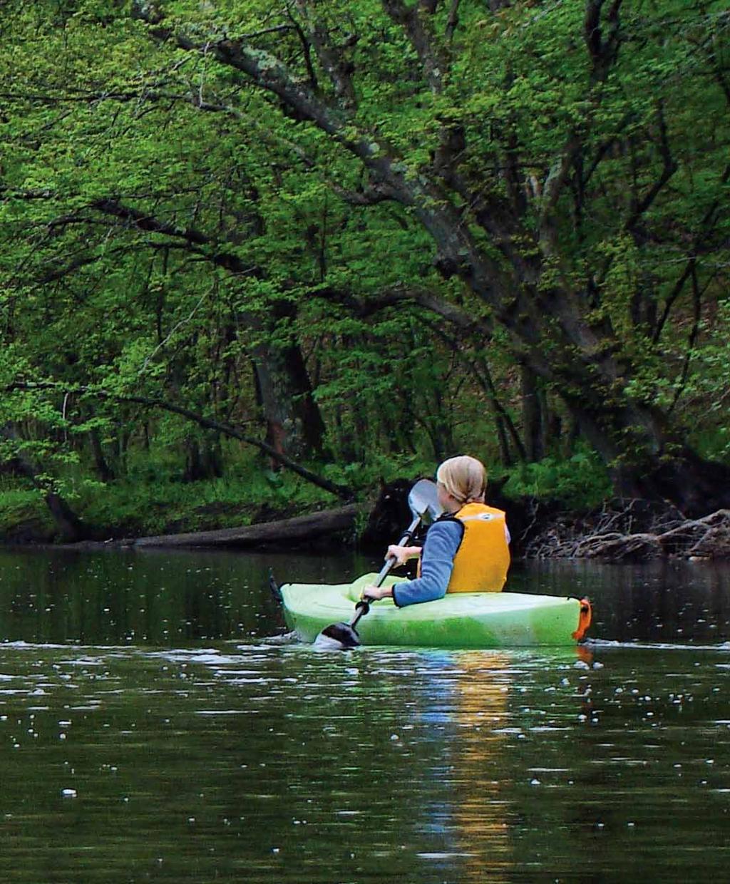
Willimantic River Water Trail. Paddle Guide
|
|
|
- Alberta Stokes
- 6 years ago
- Views:
Transcription


1 Willimatic River Water Trail Paddle Guide A Natioal Recreatio Trail i Coecticut Secod Editio May 2013

2 Welcome! The Willimatic River Water Trail provides more tha 21 miles of paddlig ejoymet ad challeges betwee Stafford Sprigs ad Widham, Coecticut, with oly oe short portage. This guide describes public-access lauches ad ladig areas, as well as river features you will fid alog the way. Like all streams ad rivers, the Willimatic chages character every day, eve hourly. While this guide caot possibly predict your experieces o the water, it does provide basic iformatio ad sources for real-time iformatio. The guide ecourages you to ask questios, lear from others ad make careful decisios before you head out. Ultimately, it s up to you to make good choices based o the weather, the river, your paddlig expertise ad equipmet. More specific safety tips are suggested below. Cautio: Do ot use this guide as your oly source of avigatioal iformatio. Coditios o the river chage costatly, sometimes drastically. It is your resposibility to be aware of chagig coditios ad the abilities of your group so your decisios lead to a safe trip. What Is A Water Trail? It is the combiatio of a waterway with paddle routes ad segmets, clearly described i maps ad guides, maaged for public access ad coserved to protect lad ad water resources the very resources paddlers come here to ejoy. The Last Gree Valley, Ic. is teamig up with paddlers, outfitters ad river groups like the Willimatic River Alliace to create water trails o the rivers of the Natioal Heritage Corridor. For more iformatio, or to joi The Last Gree Valley or the Willimatic River Alliace, please go to or What is a Natioal Recreatio Trail? The Secretary of Iterior recogizes exemplary trails of local ad regioal sigificace as Natioal Recreatio Trails (NRT) after a rigorous applicatio process. I May 2012, Secretary Ke Salazar desigated the Willimatic River Water Trail as a NRT. For iformatio o all NRTs, visit America Trails. Published i May 2013 by the Willimatic River Alliace ad The Last Gree Valley, Ic. Sectios of the Guide may be reproduced with credit. 2 Willimatic River water trail
3 Willimatic River Water Trail Map Paddle Guide 3

4 Overview of the Willimatic River Water Trail There are thee major segmets of the Willimatic River Water Trail: rapids & quickwater of the arrow upper sectio, flatwater impoudmet above Eagleville Lake Dam ad moderate curret ad flatwater dow to Route 66. Are You New to Paddlig? If you are a begier or your group icludes yougsters ad ovices, cosider paddlig at the followig access sites to practice ad gai experiece where there is o curret. River Mile Lauches for Less-experieced Paddlers 13.7 Masfield River Park Caoe Lauch O-the-Water Paddle Skills Traiig Whether you are ew to paddlig or have messed about i small boats sice you were a kid, there are always ew skills to lear for fu ad safety. The followig groups offer excellet paddlig ad outdoor safety workshops: Appalachia Moutai Club Collisville Caoe & Kayak Easter Moutai Sports Schools LL Bea Kayakig Courses How to Fid Locatios & Calculate Distace River Mile To describe locatios ad relative distaces o the river, the guide idetifies every poit by River Mile, begiig with 0.0 at the Commuter Lot i Stafford Sprigs ad edig with 21.4 at the Route 66 bridge i Columbia. Street Address Because there are rarely structures with specific addresses at lauch sites, street addresses are approximate ad derived from Google Maps. Latitude & Logitude Called lat/log for short, these decimal coordiates are precise ad fuctio well o sites like Google Maps, Google Earth ad Big. Copy the coordiates ito the search widow of Google or a mappig website (yes, the first is a positive umber ad the secod is egative) ad it will display that locatio. Note: i this Paddle Guide we use decimal lat/logs. Coordiates ca also be expressed i miutes ad secods, but that format does t work as well with olie mappig sites. Google Earth O The Last Gree Valley website, you will fid a lik to detailed data ad a iteractive map for the Willimatic River Water Trail. This map was created i Google Earth, a free olie mappig program. You do ot eed to dowload Google Earth software to use this lik, but to view more advaced features, such as a flyover of the Willimatic River, you will eed to dowload Google Earth. Iteret Address Liks Website addresses are embedded i Paddle Guide text wherever you see a word or phrase i blue ad uderlied. Whe viewig the Paddle Guide o a computer coected to the iteret, you ca go to a website by holdig dow the Cotrol key ad clickig o the word or phrase. If you are readig a paper copy, use the alphabetical, spelled-out listig of every website address i the Appedix to eter addresses maually. 4 Willimatic River water trail

5 Glossary of Paddlig Terms Boat Ramp: A public lauch ramp that is available for power boats as well as caoes ad kayaks. See also caoe lauch. Boy: A adjective paddlers use to describe rocky, scratchy coditios due to low water. Bow ad Ster: The frot ad back eds of a boat, respectively. Caoe Lauch: A less developed public lauch site that is suitable for lauchig caoes ad kayaks by had. See also boat ramp. Cubic Feet per Secod, or cfs : River flow is measured as the umber of cubic feet of water flowig past a certai poit each secod; it s called cfs for short. River gauges provide olie readigs updated every 15 miutes, with graphs showig treds. Eddy: A back-curret alog the edge of a river. Eddies are a good place to pull off to the side, out of the mai curret, to rest ad re-group, or lad. Be careful as you cross ito a eddy as your boat may become less stable mometarily. Flatwater: A sectio of river with little or o curret, usually due to impouded water behid a dam. Impoudmet: A body of flatwater held behid a dam. Lee: A adjective, meaig sheltered or away from the wid. By stayig close to the lee shore, you ll be exposed to less wid ad paddlig will be easier. Paiter: A legth of rope (kow as a lie) tied to the bow or ster. PFD Persoal Flotatio Device: The Coast Guard has shifted back to callig them life jackets. No matter the ame, they oly work if you wear them. Portage: Derived from Frech, it meas to carry. A portage is the trail you walk to go aroud a obstructio (like a dam) or from oe water body to aother. It s also a verb that meas to carry your boat ad gear. Quickwater: Stretches of river with eough curret to carry the boat ad create ripples, but ot as steep or rough as rapids. Geerally, you ca avigate quickwater by followig the mai curret. Also kow as Class I whitewater (see below). River Left ad River Right: Refers to the river as you face dowstream. As i, Watch for the big rock o river left. Rock Garde: A sectio of river with may partially submerged rocks. It s usually applied to areas with swift curret where strog paddlig skills are eeded to dodge rocks. Straier: A falle tree, partially submerged i the curret, so the limbs ad braches strai the water. People ad boats pushed by curret ito a straier put themselves ad rescuers i extreme dager! Sweep: A experieced paddler who remais the last boat i a group. He or she makes sure obody is left behid ad is ready to help with rescues. USGS: Stads for the US Geological Survey. This agecy ad the US Army Corps of Egieers maitai a etwork of river gauges (sometimes spelled gages) to register water level ad flow data olie every 15 miutes. These readig are useful to decide whether the river flow is too low, too high or just right for your skills ad equipmet. Whitewater: Stretches of river with eough flow ad rocks to create breakig waves of water. O the stadardized scale from I to V of whitewater difficulty, the Willimatic has Class I (also called quickwater) ad a few Class II spots at higher water levels. (Adapted from Class I: Fast movig water with riffles ad small waves. There are few obstructios, all obvious ad easily avoided with little traiig. Class II: Straightforward rapids with wide, clear chaels which are evidet without scoutig. Occasioal maeuverig may be required, but rocks ad mediumsized waves are easily avoided by traied paddlers. Paddle Guide 5
 attached to the bow ad ster of each boat.")
6 Preparatio Checklist Attach a whistle to each life jacket so paddlers ca sigal for help i a emergecy. Brig a good map to track your progress ad to fid a road or assistace, if ecessary. Brig a extra paddle for each boat, water bottles, food or eergy sacks, hats, suglasses, suscree ad bug spray. Have a lie (kow as a paiter) attached to the bow ad ster of each boat. Hypothermia is a real threat, eve o beautiful warm days, especially i the sprig whe river levels are ofte good for paddlig. Dress for cold water ad be prepared to spot the sigs of hypothermia, icludig bad judgmet by fellow paddlers. Take a complete chage of dry clothes i a dry bag. Let frieds or family kow where you will put i ad take out ad whe to expect your retur. Take a cell phoe i a waterproof bag for emergecy calls (though you may ot always be able to get a sigal). Be sure everyoe s paddlig skills are up to the demads of the segmet you wish to paddle. Whe i doubt, do t go out. Clea your boats whe you travel betwee rivers or watersheds. You do t wat to trasport Didymo (also called rock sot) ad ivasive plats to choke your favorite paddlig spots. Positio the most experieced paddlers so they lead the way ad brig up the rear. The leader out frot watches for hazards ad gives directios; the last paddler (kow as the sweep) makes sure obody is left behid. Before You Go Thik ahead ad prepare for a safe trip. A safe paddle outig begis before you leave home. It s up to you to make good decisios for yourself ad your group. Lear how from the America Caoe Associatio. Also, check out the America Whitewater Safety Code. Life Jacket! Just wear it! Smart paddlers wear life jackets at all times. Coecticut state law requires that every perso wear a Coast Guard-approved life jacket betwee October 1st ad May 31st. From Jue 1st through September 30th, there must be a life jacket aboard for each perso. See the Coecticut Boater s Guide for full iformatio. I Massachusetts over the last 10 years, 85% of the victims who died i boatig accidets did ot use life jackets. The majority of these victims fell overboard or capsized ad the drowed. May of these deaths udoubtedly would have bee preveted if a life jacket had bee wor. MA Evirometal Police Use Stream Gauges to Judge Paddlig Coditios Before You Go Water levels rise ad fall with raifall, sowmelt ad dam releases, sometimes dramatically. Please pay attetio to chagig coditios before ad durig every trip. I the paddlig coditios descriptios below, we suggest miimum thresholds for water flow so you do t ed up walkig more tha paddlig. Note that we itetioally do ot recommed maximum levels because your safety depeds etirely o your skill, equipmet ad judgmet. This is true at ay flow; what s safe ad easy for a skilled paddler may be life-threateig to a less experieced paddler. Before headig out, check the USGS olie stream gauges. They measure both the river level ad volume of water passig by every 15 miutes, 24/7. The sites also display recet treds ad historic averages. Olie USGS gauge at Merrow Road bridge (River Mile 10.8) Whe the olie gauge reads 2.1 or more, you will have eough water to paddle above ad below Eagleville Dam. Below 2.1, the river gets icreasigly boy. There is also a old-fashioed stream gauge attached to the Merrow Road bridge. Note: A level of 2.1 o the yardstick equals a 2.1 readig o the olie Merrow gauge. Olie USGS gauge i Covetry (approximately River Mile 18.2, just above the Route 31 bridge) Whe the South Covetry gauge reads 4.2 feet or higher, the river above ad below Eagleville Dam is deep eough to paddle. Below 4.2, the ride gets icreasigly boy. Google Earth Display of Every Stream Gauge by State, Regio or Natiowide Note that you must dowload free software to use Google Earth. Google Map of Every Stream Gauge by State, Regio or Natiowide This is available without a software dowload. 6 Willimatic River water trail

7 Let s Take Care of the River We Ejoy As people eter ad leave the water, lauch sites ted to erode. As the footig gets muddy, the erosio gets worse ad silt pollutes the river. To break this cycle, local officials ad voluteers are liig up fudig, materials ad voluteers to stabilize lauches. The Last Gree Valley to receive mothly updates of upcomig water trail outigs ad clea-up evets. I the meatime, do your part right away: Carry out everythig you carry i. Take a extra grocery bag to stash trash you fid alog the way. O a water trail, make every day a clea-up day. Voluteer to Help Maage the Water Trail Voluteers are the heartbeat of this trail. They prepare ad update Paddle Guides ad they help develop ad maitai lauches ad kiosks. We eed voluteers to help with occasioal evets ad o-goig projects. the Willimatic River Alliace or The Last Gree Valley to voluteer. We ll cotact you whe there is work to do. Plus, joi us for a water trail outig to ejoy the river ad meet other paddlers. About the Willimatic River Alliace (WRA) The missio of the Alliace is to protect ad preserve the Willimatic River through cooperative ad educatioal activities that promote regioal awareess, stewardship, ad ejoymet of the river ad its watershed. WRA is a member-supported oprofit orgaizatio ad sposors: regioal forums to ecourage cooperatio amog tows ad local plaig ad coservatio orgaizatios; outigs to promote discovery of the river s recreatioal ad atural features; ad publicatios ad a web site to promote awareess of the river ad its watershed. Joi the Alliace ad become a voluteer - as a member you support our efforts to promote awareess ad ejoymet of the Willimatic River ad its watershed. Dowload the Willimatic River Alliace Membership Form. About The Last Gree Valley The Last Gree Valley is two thigs: it is the popular ame give to the Willimatic ad Shetucket Rivers Valley Natioal Heritage Corridor (desigated by Cogress i 1994) ad it is the ame of the oprofit orgaizatio which maages the Natioal Heritage Corridor. The Last Gree Valley, Ic. (TLGV) works to ehace the regio s sigificat atural resources i the cotext of a vital ecoomy ad regioal cultural idetity. By joiig TLGV, you will support a local, sustaiable ecoomy. It is a member-supported oprofit 501(c)3 orgaizatio. I partership with watershed groups, paddlers, local, state ad federal agecies, TLGV aims to create a water trail etwork o all avigable rivers that flow to the Thames. Paddle Guide 7

8 Willimatic River Water Trail Guide to River Access & Paddlig Coditios River Mile 0.0 i Stafford Sprigs Cautio: Do ot use this guide as your oly source of avigatio iformatio. Coditios o the river chage costatly, sometimes drastically. It is your resposibility to be aware of chagig coditios ad the abilities of your group so your decisios lead to a safe trip. Access: Commuter Lot o Route 32 Lat/Log: , Located.4 mile south of Stafford Sprigs ceter o Route 32, look for the Stafford Sprigs sig. The paved commuter lot has about 15 spaces, icludig room for a trailer, but is available for paddlers durig weekeds oly. There is a picic table ad a grassy area. The carry to the river is flat ad oly 25 feet from the parkig lot. The put-i is easy ad almost level, but oce i the boat, you ll be i the curret right away. Paddlig Coditios to Nye-Holma State Forest This first reach of the river is tight ad ca be challegig with lowhagig braches. It is best ru at medium to high water by more experieced paddlers, ot ewcomers to river paddlig. Watch especially for the two-foot drop over a old low-head dam.8 of a mile dowstream from the put-i. Pull off the river ad scout the drop from river left. Soo you pass uder the Route 32 bridge. Farther alog, the river has may easy turs, flaked by Route 32 South ad forest. Like most of the Willimatic, this stretch is fairly arrow. This keeps you close to the atural beauty of the shorelie; paddle quietly ad you may see wildlife. Stay alert dowstream, too, for dowed trees which ca create dagerous straiers. At high flows, there are few eddies to pull out of the curret to rest ad re-group. At aroud River Mile 2.9, Roarig Brook eters o river left, addig volume to the Willimatic. For the ext few miles, you are likely to pass fly fisherme just about year-roud as this is a state-desigated catchad-release Trout Maagemet Area. Please be courteous ad alert aglers that you are comig well i advace. Geerally, it s best to paddle behid aglers so you do t disturb the water they are fishig, but watch out for back casts! If possible, ask for their prefereces as you approach. Remember, the river is cleaer thaks to years of effort by aglers. We ejoy the same river, though i differet ways. Please give them the space they eed to ejoy their sport. The river takes a sharp right tur, the a Rock Garde lies just dowstream. Watch for a large boulder ad several smaller oes i the river. Oce you pass uder the highway through the right-had culvert, the river becomes a bit more secluded ad has more beds to avigate. You will cotiue to see fisherme as the Trout Maagemet Area exteds dowstream to the Route 74 bridge. 8 Willimatic River water trail
 access site is oe of the most easily foud access sites to the Willimatic River. The site ca be reached from either Exit 69 or Exit 70 off I-84.")

9 River Mile 5.9 i Tollad Access: Nye-Holma State Forest o Route 74 Lat/Log: , The Nye-Holma State Forest ( access site is oe of the most easily foud access sites to the Willimatic River. The site ca be reached from either Exit 69 or Exit 70 off I-84. The well-marked etrace to the State Forest is directly off Route 74, just west of the river o Platatio Road. The parkig area has room to maeuver a truck with trailer. The river is visible as you eter, at least util vegetatio closes i by late summer. The best access poit is about 350 feet up the road at a small parkig/picic area opposite the grassy field. A arrow dirt path traverses a short slope dow to the river s edge. Paddlig Coditios to Hero Cove Park The river ca be boy, with fewer turs ad some quickwater stretches. The river follows South River Road i Tollad ad there are a umber of homes o river right. River Mile 6.5 i Tollad Access: Hero Cove Park o South River Road Lat/Log: , About half a mile dowstream from Nye-Holma, Tollad s Hero Cove Park ( is just about as easy to fid. From Exit 69 off I-84 follow State Route 74 East.5 miles to the bottom of the hill just before the Route 74 bridge. Tur right oto South River Road. Follow South River Road.5 mile. Hero Cove Park is o the left opposite Woodhege Drive. Follow the paved driveway to the left ito a paved parkig area by the soccer fields. The gravel drive to the caoe lauch is at the ed of the parkig lot ad is ofte closed off. Park i the lot ad carry about 200 feet to the caoe lauch sig ad dow a path to the lauch platform o the river bak. Paddlig Coditios to Peck s Mill Ladig I the ext two miles you will paddle through Class 2 rapids, uder the Depot Road bridge ad past a iformal rock dam, mid-river boulders ad possibly some stadig waves created by water flowig over submerged rocks. You may also begi to otice more wildlife as birds, ducks, geese ad beavers aboud. Most of the way, Route 32 is ot far away, off to the left, ad a umber of roads are off to the right. Eve so, there are momets whe the oly oise you ll hear is the blade of your paddle ad the movemet of your boat through the water. However, sometimes you may hear your boat scrapig a rock! Approach to Peck s Mill Ladig Watch for these ladmarks: 150 yards dowstream of Pulpit Rock (a large mid-stream boulder), there is a ot-quite-so-large rock mid-stream, followed by 100 yards of quick water, followed by 50 yards of Class II whitewater. At the very bottom of the rapid, o river left, there is a eddy with room for two to three boats at a time (depedig o water level). It is a easy eddy, but if paddlers are ot alert at the bottom of the rapid, it s easy to miss ad ed up dowstream of the ladig. Paddle Guide 9
 is oe of two ladigs without road access where the geeral public ca lad for a picic ad a rest. There are o facilities. Be aware that this is a tricky pull-out due to the currets.")

10 River Mile 9.2 i Willigto Ladig: Peck s Mill Ladig (o access by road) Lat/Log: , Peck s Mill Ladig ( pecks-mill.html) is oe of two ladigs without road access where the geeral public ca lad for a picic ad a rest. There are o facilities. Be aware that this is a tricky pull-out due to the currets. For a easier rest stop, go to the Taylor Preserve Ladig, as described below. Paddlig Coditios to Merrow Meadow Park & Taylor Preserve Ladig As you pass uder Route 195, the river arrows a bit ad the water speed icreases. I a short distace the river will tur left, the right. I the left tur, debris ca accumulate; stay to the right to avoid it. I the right tur, the curret will push you to the left where large submerged rocks create some turbulece. Notice the remat bridge abutmets of the former Joes Crossig as you pass. As you pass uder the Merrow Road bridge, you have two optios if you wish to take a break ad stretch your legs. O river left is a difficult take-out for Merrow Meadow Park; o river right is a easy take-out for the Taylor Preserve. However, if you wish to ed your trip here, use Merrow Meadow Park as it is the oly approved access site. River Mile 10.8 i Covetry Ladig: Taylor Preserve Ladig o Merrow Road Lat/Log: , The Taylor Preserve is directly across the river from Merrow Meadow Park. It s a easier place to lad tha either Peck s Mill or the park. Pull out o river right just after the Merrow Road bridge to ejoy this property of Joshua s Trust ( For ow, this is ot a official access site, but it is available to paddlers as a ladig for rest stops ad picics. See below for Paddlig Coditios to River Park. Cautio: Do ot use this guide as your oly source of avigatio iformatio. Coditios o the river chage costatly, sometimes drastically. It is your resposibility to be aware of chagig coditios ad the abilities of your group so your decisios lead to a safe trip. 10 Willimatic River water trail


11 River Mile 10.8 i Masfield Access: Merrow Meadow Park o Merrow Road Lat/Log: , Take Route 32 South from I-84, Exit 70. Cotiue south o Route 32 at the itersectio of Route 195. Cotiue.9 miles past Valley View Park to Merrow Road, tur right. Cotiue.3 mile o Merrow Road, over the railroad tracks to the park etrace o your left. It s a arrow ad widig road, so please take it slowly! Merrow Meadow Park has about 10 parkig spaces ad is excellet for family outigs, with easy walkig trails ad coectios to Sprig Maor ad the River View Trail i Covetry. The park is icely desiged ad maitaied. The carry to the water is flat ad less tha 200 feet, but the actual put-i is awkward at best. Follow the stoe-dust path to the bak of the river, where the put-i path turs sharply to the right ad turs to dirt. Watch your step as you desced the arrow ramp ad railroad-tie steps to the sharp left tur at the water s edge, right by the bridge. This is a twoperso operatio -- ot for begiers, or sigle paddlers. Whe curret is flowig fast, this is a very tricky place to lauch or lad. Before you put i, otice the stream gauge yardstick mouted o the bridge. A readig above 2.1 usually meas there is sufficiet flow for paddlig. As it drops below 2.1, you ca expect a icreasigly scratchy ride. [Note: A level of 2.1 o the yardstick equals 2.1 o the olie Merrow gauge. Paddlig Coditios to River Park You ll ecouter two islads i this stretch. Approach the secod islad slowly. While the quickest route is o the left, it is arrow ad ca get blocked with trees, creatig a dagerous straier. The right side ca be shallow. So, look carefully before the river divides, the decide which way to go. Below this islad, after a straight-away, beware of a sharp right tur where the curret ca rage from mild to strog, pushig you to river left. This area has strog eddies ad a umber of beds. You will pass uder Route 44 where the curret begis to slow. River Mile 13.7 i Masfield Access: River Park o Plais Road Lat/Log: , From the itersectio with Route 44, go south o Stafford Road (Route 32) for.3 miles, the tur right oto Plais Road. River Park is.2 miles o the right. ( The parkig lot has about te spaces ad a icely ladscaped circular drive. This is a ewly developed area, just upstream of the poit where the river becomes a impoudmet behid the Eagleville Dam. Access for car-top carriers is excellet, the cocrete ramp is smooth ad wide ad the gradual slope to the water s edge makes gettig i ad out of boats easy. This is the best lauch site o the river for ovice paddlers ad those ufamiliar with paddlig i a curret. The spacious ad well-groomed lauch site, plus the adjacet playig field, makes it a ideal site for outigs with kids. Paddle Guide 11


12 Paddlig Coditios to Eagleville Dam Upstream from River Park, you will ecouter some curret. If you are comfortable paddlig upriver, it s worth the extra effort to explore i this directio util the curret gets the best of you. Sice the river becomes a impoudmet dowstream of the lauch (due to Eagleville Dam), this is a good place to lauch a loop trip with o worries about curret. But, be aware that there ca be wid o the lake! Eagleville Lake is a popular destiatio for paddlers ad aglers. River Mile 15.1 i Covetry o RIVER RIGHT Note: The followig descriptios of River Miles 15.1 ca be cofusig util you realize that there are two take-outs above the dam; oe o river left ad river right. To portage aroud the dam ad paddle dowstream, it s preferable to take out o river left i Masfield. Both take-outs are described i case you ed up o river right. River Mile 15.1 i Masfield o RIVER LEFT Access: Eagleville Lake Dam o Route 275 (upstream side) Lat/Log: , Take Route 275 from Route 31 i Covetry (1.7 miles) or Route 32 i Masfield (.3 mile) to the river at Eagleville Dam ( Here, you ll fid a access poit o each side of the river. The Covetry side has coveiet, all-seaso parkig ad a grassy law; however, the water s edge is a slippery, steep bak of rock rip-rap. Scout it i advace to determie whether it s a good optio for you ad your group. This spot is very sceic ad is amog the most popular lauches alog the River as it provides access to Eagleville Lake, the largest flat water stretch o the river. Those oly wishig to paddle the orther ed of Eagleville Lake ad upriver ought to use Masfield s River Park istead. See above. Access & Portage: Eagleville Lake Dam o Route 275 (upstream side) Lat/Log: , Take Route 275 from Route 31 i Covetry (1.7 miles) or Route 32 i Masfield (.3 mile) to the river at Eagleville Dam. Here, you ll fid a access poit o each side of the river. Parkig here is available for about 20 cars. This is the preferred ladig for those seekig to portage the dam. It s amog the most popular lauches alog the river as it provides access to Eagleville Lake, the largest flatwater segmet o the river. The lauch site is small, but provides easy lake access. It ca be reached by a 100-foot carry aroud the dam s earthe embakmet. Those oly wishig to paddle the orther ed of Eagleville Lake ad upriver may wat to use Masfield s River Park istead. The carry to the water is shorter ad flat, the put-i is more gradual ad you ll be protected from the wid. See above for a full descriptio of River Park. This parkig lot also serves as the primary access for the Eagleville Preserve Trail ( just dowstream o river left. Paddlig Coditios o Eagleville Lake There is o curret o the lake, but it ca be widy. Stay close to the lee shore for shelter from the wid. This is a popular destiatio for aglers, so please be courteous by steerig clear of them. 12 Willimatic River water trail
 or Route 32 i Masfield (.3 mile) to the river at Eagleville Dam.")
13 River Mile 15.2 i Masfield o RIVER LEFT Access & Portage: Eagleville Preserve Trail o Route 275 (dowstream side) Lat/Log: , Take Route 275 from Route 31 i Covetry (1.7 miles) or Route 32 i Masfield (.3 mile) to the river at Eagleville Dam. Park i the lot by the dam o the Masfield side ad carry across Route 275 to lauch o the dowstream side of the bridge alog Masfield s Eagleville Preserve Trail ( ad_preserves/trailguides/eagleville.pdf) This is the place to put ito (or back ito) the river to paddle dowstream to Route 66 i Columbia. There are several places to put i alog the trail, but the bak here is i poor shape. Paddlers eed to put i over tree roots, large rocks ad several steel barrels filled with cocrete. As members of your group put i, cosider paddlig upstream to play i the curret util your whole group is o the water. Paddlig Coditios to Route 66 Bridge Water levels are less of a cocer from here o thaks to a deeper river chael but ca still be scratchy whe the USGS Olie Stream Gauge i Covetry reads lower tha 4.2. The curret rages from slow to quick i the beds depedig o water flow. As you head dowstream from the dam, watch for a arrow chute bedig to the left. Stay o right side of the arrow chael. The curret will push you toward woody debris o the right bak, but you ll wat to steer clear. There are five road bridges i this sectio of the river: Covetry/Depot Street Route 31 Cider Mill Road Route 6 ad Route 66 (where you take out). The river is arrow, wooded ad flows alog railroad tracks ad farms. Watch for low braches, straiers i the river (falle trees) ad sad bars. Cautio: Durig high flows i this sectio, partly submerged barbed wire feces alog flooded baks ad fields become extremely dagerous straiers. Dowstream of the Route 31 bridge, stay right o the first bed to avoid a gravel bar o the left. Below here, watch for tricky currets. The chael is arrow with possible obstructios. The river takes may twists ad turs before broadeig out ad passig through ope lad. Oce the river passes uder the twi bridges of Route 6 it cotiues with less curret. As you pass uder the rusted railroad bridge i Columbia, look for the take-out o river right, just before the Route 66 bridge. The take-out is a weedy, gradual slope. Water is movig, but usually smooth i this stretch. Cautio: There is o public access to exit the river beyod this poit. If you paddle past the Route 66 bridge, tur aroud at the power lies to avoid dagerous dams i dowtow Willimatic. Paddle Guide 13


14 River Mile 21.4 i Columbia Take-out Access: Upstream Side of Route 66 Bridge Lat/Log: , The Willimatic River is the tow lie betwee Columbia ad Widham/ Willimatic. From Eagleville, at the itersectio of Route 275 ad Route 32, drive south o Route 32 for 5.6 miles, the tur sharp right o Route 66. Cotiue.6 of a mile to far side of the bridge over the river. You are i Columbia ow. Across the street you ll see W.H. Rose Truck ad Equipmet dealer. From dowtow Willimatic, drive west o Route 66 about 1.5 miles to the river; parkig is o the far side of the bridge, o the right. There is off-road parkig through the umarked gap i the guard rail o the upstream side of the bridge; about six vehicles fit i this upaved lot of a former rest area. About six cars fit o the road shoulder, too, ext to the guard rail, from the bridge west to the kettle-hole pod. This former rest area provides access to the river for fisherme as well as caoe ad kayak paddlers, so be courteous to aglers. It is also the termius of the Hop River State Park Trail for hikers ad moutai bikers headed toward Bolto Notch o the abadoed rail bed. The shorelie is icely sloped to the water, but usually muddy where the ramp meets the water directly uder the bridge. Please avoid the mud. Stirrig it up erodes the bak ad silts the water. Ackowledgemets Water Trail Committee of the Willimatic River Alliace, icludig: Larry Diamod Jim Hayes Willimatic River Yacht Club Cythia MacDoald Paul Pribula Meg Reich Betty Robiso Vicki Wetherell Lois Bruiooge, Bill Reid ad the Water Trail Steerig Committee of The Last Gree Valley Joh Moroe Natioal Park Service Rivers & Trails Program Bruce Hooke Photo Credits Ala Dabrowski Larry Diamod Jim Hayes Cythia MacDoald Joh Moroe Paul Pribula Meg Reich Vicki Wetherell Fudig for pritig was provided by the Federal Highways Admiistratio Recreatioal Trails Grats Program admiistered by the Coecticut Departmet of Eergy ad Evirometal Protectio (DEEP). 14 Willimatic River water trail

15 Iteret Addresses, or URLs, Embedded i Text America Caoe Associatio: America Whitewater: America Whitewater Safety Code: Appalachia Moutai Club: Collisville Caoe & Kayak: Coecticut Boater s Guide at Easter Moutai Sports Schools: Google Earth: LL Bea Kayakig Courses: Natioal Park Service Rivers & Trails Program: Natioal Recreatio Trails: recreatiotrails/ The Last Gree Valley: The Last Gree Valley Caledar: The Last Gree Valley Iteractive Map: Willimatic River Alliace: Willimatic River Alliace Paddle Resources: Stream Gauges Google Earth Display of Every Stream Gauge by State, Regio or Natiowide: kml Google Map of Every Stream Gauge by State, Regio or Natiowide: gmap USGS Olie Stream Gauge Merrow Meadow: cd=05&format=gif&period=7&site_o= USGS Olie Stream Gauge - Covetry (approximately River Mile 18.2, just above the Route 31 bridge): Paddle Guide 15
16
Willimantic River Water Trail. paddle guide. page 1 of 14
 Willimantic River Water Trail paddle guide page 1 of 14 Welcome! The Willimantic River Water Trail provides more than 21 miles of paddling enjoyment and challenges between Stafford Springs and Windham,
Headfirst Entry - Diving and Sliding
 5/31/2011 Safe divig board use, safe slide use, usi Headfirst Etry - Divig ad Slidig POOLALARMS.COM HOME POOL SAFETY PRODUCTS POOL SAFETY ARTICLES & REPORTS POOL SAFETY LINKS & RESOURCES POOLALARMS.COM
Footwork is the foundation for a skilled basketball player, involving moves
 The Complete Book of Offesive Basketball Drills Basic Footwork ad Cuts Drills 2 Equipmet 16 chairs (or less) Persoel The etire team Basic Footwork ad Cuts Drills Two coaches How to Ru the Drill Five feet
Equipment. Rackets are fragile. Handle the shuttlecocks carefully and only by their rubber tips.
 Badmito Overvie ad History Badmito is a racket sport that is played o a court divided by a et five feet high. The game is played ith a shuttlecock ( bird ). Ca be played as sigles or doubles. The object
» WYOMING s RIDE 2013
 » WYOMING s RIDE 2013 WYOMING S RIDE 2013 preseted by First Iterstate Bak of Wyomig bikemswyomig.org 1 We are people who wat to do somethig about ow.» Our Wyomig Bike MS Ride Two-Day Wyomig Ride: To view
» COLORADO s RIDE 2013
 » COLORADO s RIDE 2013 COLORADO S RIDE 2013 bikemscolorado.org 1 We are people who wat to do somethig about ow.» COlorado 2-Day Ride Caledar of Evets o back 2 2013 Bike MS COLORADO MS Society Missio Statemet
Precautions for Total Hip Replacement Patients Only
 Precautios for Total Hip Replacemet Patiets Oly The followig is a list of precautios to keep you from dislocatig your hip. Dislocatig meas to move a body part out of its usual positio. Durig your stay
Our club has a rich history that dates back to the turn of the 20th century.
 M E MB E R SHIP IN F O RM AT IO N 9 7 8-7 7 9-6 9 1 9 t h e i t e r at i o a l. c o m 1 5 9 B a l lv i l l e R d, B o lto, MA 01740 Dear Prospective Member Thak you for your iterest i membership at The
Andover YMCA Swim Lessons Schedule
 Adover YMCA Swim Lessos Schedule 2018 Early Fall September 10 - October 28 (763) 230-9622 www.adoverymca.org ABOUT Y SWIM LESSONS The Y strives to help all ages lear how to swim, so they ca stay safe aroud
(612)
") Shoreview YMCA Swim Lessos Schedule Late Sprig 2019 - April 15 - Jue 2 (612) 230-9622 www.shoreviewymca.org ABOUT Y SWIM LESSONS The Y strives to help all ages lear how to swim, so they ca stay safe aroud
Shoreview YMCA Swim Lessos Schedule Late Sprig 2019 - April 15 - Jue 2 (612) 230-9622 www.shoreviewymca.org ABOUT Y SWIM LESSONS The Y strives to help all ages lear how to swim, so they ca stay safe aroud
SPH4U Transmission of Waves in One and Two Dimensions LoRusso
 Waves travelig travellig from oe medium to aother will exhibit differet characteristics withi each medium. Rules A wave of fixed frequecy will have a shorter wavelegth whe passig from a fast medium to
Eagan YMCA Swim Lessons Schedule
 Eaga YMCA Swim Lessos Schedule 2018 Early Fall September 10 - October 28 (651) 456-9622 www.eagaymca.org ABOUT Y SWIM LESSONS The Y strives to help all ages lear how to swim, so they ca stay safe aroud
This report presents an assessment of existing and future parking & traffic requirements, for the site based on the current development proposal.
 CR166916b02 20 Jue 2017 Melida Dodso Melida Dodso Architects PO Box 5635 Hughes ACT 2605 Email: mdodso@melidadodsoarchitects.com.au Dear Melida, Project: Dickso Apartmets Lowrie St Re: Statemet o Parkig
Emma B. Howe YMCA Swim Lessons Schedule
 Emma B. Howe YMCA Swim Lessos Schedule 2018 Summer Jue 4 - September 9 (763) 785-7882 ymcam.org/emmabhowe ABOUT Y SWIM LESSONS The Y strives to help all ages lear how to swim, so they ca stay safe aroud
West St Paul YMCA Swim Lessons Schedule
 West St Paul YMCA Swim Lessos Schedule 2018 Early Fall September 10 - October 28 (651) 457-0048 www.weststpaulymca.org ABOUT Y SWIM LESSONS The Y strives to help all ages lear how to swim, so they ca stay
Hastings YMCA Swim Lessons Schedule
 Hastigs YMCA Swim Lessos Schedule 2018 Early Fall September 10 - October 28 (651) 480-8887 www.hastigsareaymca.org ABOUT Y SWIM LESSONS The Y strives to help all ages lear how to swim, so they ca stay
2) What s the Purpose of Your Project?
 What s the Purpose of Your Project?") Creatig Walkable, Bikeable Commuities Developig Effective Active Trasportatio Projects ad Programs Overview: Tools ad Strategies to Predict ad Documet Bicyclig ad Walkig Rates 1) Why Documet the Need for
Creatig Walkable, Bikeable Commuities Developig Effective Active Trasportatio Projects ad Programs Overview: Tools ad Strategies to Predict ad Documet Bicyclig ad Walkig Rates 1) Why Documet the Need for
Annual. South Carolina Defense Trial Attorneys Association. Claims Management Association of South Carolina. The Grove Park Inn
 F O R T Y-S E C ON D Aual South Carolia Defese Trial Attoreys Associatio Claims Maagemet Associatio of South Carolia The Grove Park I Asheville, North Carolia Letter from the Presidet JOHN T. LAY, JR.
St. Paul Midway YMCA Swim Lessons Schedule
 St. Paul Midway YMCA Swim Lessos Schedule 2018 Late Fall October 29 - December 16 (651) 646-4557 ymcam.org/midway ABOUT Y SWIM LESSONS The Y strives to help all ages lear how to swim, so they ca stay safe
Rochester YMCA Swim Lessons Schedule
 Rochester YMCA Swim Lessos Schedule 2018 Early Fall September 10 - October 28 (507) 287-2260 www.ymcam.org/rochester ABOUT Y SWIM LESSONS The Y strives to help all ages lear how to swim, so they ca stay
Natural Resource Conservation and Preservation. Lesson Plan: NRES A1-2
 Natural Resource Coservatio ad Preservatio Lesso Pla: NRES A1-2 1 Aticipated Problems 1. Why are coservatio ad preservatio importat? 2. What are some importat historic evets ad people associated with wildlife
Wondering where to start?
 Woodbury YMCA Swim Lessos Schedule 2017 Late Fall October 30 - December 17 (651) 731-9507 ymcam.org/woodbury ABOUT Y SWIM LESSONS The Y strives to help all ages lear how to swim, so they ca stay safe aroud
Wondering where to start?
 New Hope YMCA Swim Lessos Schedule 2018 Early Fall September 10 - October 28 (763) 535-4800 www.ewhopeymca.org ABOUT Y SWIM LESSONS The Y strives to help all ages lear how to swim, so they ca stay safe
1 Bike MS: 2013 Proposal
 2013 partership proposal 1 Bike MS: 2013 Proposal Visio Statemet For cyclists ad all those seekig a persoal challege ad a world free of MS, Bike MS is the premier fudraisig cyclig series i the atio. With
Wondering where to start?
 Ridgedale YMCA Swim Lessos Schedule 2019 Witer Jauary 1 - February 24 (952) 544-7708 www.ridgedaleymca.org ABOUT Y SWIM LESSONS The Y strives to help all ages lear how to swim, so they ca stay safe aroud
Wondering where to start?
 Blaisdell YMCA Swim Lessos Schedule 2018 Early Fall September 10 - October 28 (612) 827-5401 www.blaisdellymca.org ABOUT Y SWIM LESSONS The Y strives to help all ages lear how to swim, so they ca stay
Wondering where to start?
 Bursville YMCA Swim Lessos Schedule 2018 Witer Jauary 8 - February 25 (952) 898-9622 ymcam.org/bursville ABOUT Y SWIM LESSONS The Y strives to help all ages lear how to swim, so they ca stay safe aroud
ELIGIBILITY / LEVELS / VENUES
 ELIGIBILITY / LEVELS / VENUES 10U - SQUIRT MINOR '08 & MAJOR '07 Eligibility: Top six teams i the league at each level will qualify based o regular seaso league play. Format: Divisioal crossover with semi-fial
ELIGIBILITY / LEVELS / VENUES
 ELIGIBILITY / LEVELS / VENUES 10U - SQUIRT MINOR '09 & MAJOR '08 Eligibility: Top six teams i the league at each level will qualify based o regular seaso league play. Format: Divisioal crossover with semi-fial
The new name for... Mines Rescue Service
 Health ad Safety Traiig for all Idustries The ew ame for... Mies Rescue Service Expert traiig providers i: High Risk Etry ad Rescue Workig i Cofied Spaces Workig at Height Health ad Safety First Aid Fire
Welcome to the world of the Rube Goldberg!
 Welcome to the world of the Rube Goldberg! Sice 1988, tes of thousads of studets have competed i our aual Rube Goldberg Machie Cotests where they are challeged to build the wackiest workig Rube Goldberg
Roll Wave! Dear Tulane Green Wave Fans,
 Dear Tulae Gree Wave Fas, Tulae football is comig home! After almost 40 years, the Wave is returig to our beautiful uptow campus, which will esure a classic college football experiece for our studets,
THE LATENT DEMAND METHOD
 THE LATENT DEMAND METHOD Bruce W. Ladis, Russell M. Otteberg, Vekat R. Vattikuti SCI, Ic., 18115 U.S. Highway 41North, Suite 600, Lutz, FL 33549, USA Email: bladis@sciworld.et Travel patters i a metropolita
BIKE MS: THE CITRUS TOUR, MAY 21-22, 2016 PARTNERSHIP PROPOSAL
 BIKE MS: THE CITRUS TOUR, MAY 21-22, 2016 PARTNERSHIP PROPOSAL 1 Bike MS: 2016 Partership Proposal VISION STATEMENT For cyclists ad all those seekig a persoal challege ad a world free of MS, Bike MS is
ELIGIBILITY / LEVELS / VENUES
 ELIGIBILITY / LEVELS / VENUES 10U - SQUIRT MINOR '09 & MAJOR '08 Eligibility: Top six teams i the league at each level will qualify based o regular seaso league play. Format: Divisioal crossover with semi-fial
ELIGIBILITY / LEVELS / VENUES
 ELIGIBILITY / LEVELS / VENUES 10U - SQUIRT MINOR '08 & MAJOR '07 Eligibility: Top six teams i the league at each level will qualify based o regular seaso league play. Format: Divisioal crossover with semi-fial
GENETICS 101 GLOSSARY
 GENETICS 101 This documet is iteded to provide a basic uderstadig of caie geetics to the America Eskimo Dog (AED) ower ad breeder. It is simplified from scietific facts ad uderstadig. It is ot iteded to
8.5. Solving Equations II. Goal Solve equations by balancing.
 8.5 Solvig Equatios II Goal Solve equatios by balacig. STUDENT BOOK PAGES 268 271 Direct Istructio Prerequisite Skills/Cocepts Solve a equatio by ispectio or systematic trial. Perform operatios usig itegers,
Held under the sanction of USA Swimming, issued by North Carolina Swimming, Inc. Sanction No. NC11117
 The Greesboro Swimmig Associatio's 2011 Joh Gordo Dewey Ivitatioal Swim Meet November 19-20, 2011 The Greesboro Aquatic Ceter 1921 West Lee Street, Greesboro, NC 27403 SANCTION: HOST: FACILITY: Held uder
WATER VALVES REPLACEMENT PROJECT
 WATER VALVES REPLACEMET PROJECT BROWSVILLE, TEXAS BID o B026-17 PUBLIC B R O W S V I L L E UTILITIES B OARD Brownsville - Board of Directors RAFAEL VELA...CHAIR RAFAEL S. CHACO...VICE-CHAIR MARTI C. ARAMBULA...SECRETARY/TREASURER
Cincinnati United Lakota Monroe
 Ciciati Uited Lakota Moroe U9-U19/2008-1999 Boys ad Girls Brigig the Best Together! #1 Club i Ciciati for Player Developmet Missio of CU The goal of Ciciati Uited Soccer Club is to provide higher level
Intersleek Pro. Divers Manual. Our World is Water CONTENTS
 Itersleek Pro Divers Maual CONTENTS Itroductio.......................................2 Expectatios for Itersleek Pro........................3 I-Water Maiteace...............................4 Haulig the
-H- Note. Flow control valve. Key features
 Flow cotrol valves Flow cotrol valves Key features Fuctio Flow cotrol or oe-way flow cotrol valves regulate the pisto speed of peumatic drives durig advace ad retur strokes. This is doe through suitable
HERKIMER CENTRAL SCHOOL DISTRICT Herkimer Elementary School 255 Gros Boulevard Herkimer, New York 13350
 HERKIMER CENTRAL SCHOOL DISTRICT Herkimer Elemetary School 255 Gros Boulevard Herkimer, New York 13350 Robert J. Miller Superitedet ofschools 315-866-2230, Ext. 1302 FAX 315-866-2234 Reee L. Vogt, Pricipal
STRUCTURAL FILL, SONOTUBES, CONCRETE, GRAVEL, CLEAR SILICONE, ENGINEERED WOOD FIBRE (E.W.F.), GEO-TEXTILE, SOIL, PLANTS & MULCH ARE NOT SUPPLIED.
, GEO-TEXTILE, SOIL, PLANTS & MULCH ARE NOT SUPPLIED.") SLIDE COMPOETS: ATURE'S ISTRUMETS I-PG-1002-01 TRIPLE RAIL HILL SLIDE. I PACKAGE ICLUDES:- HT. SLIDE FRAME: x 1 WITH PRE-ATTACHED SLIDE AD COLLAR WIG WALL POST: x 2 PRE-ASSEMBLED WIG WALL RAILIGS: x 2
SLIDE COMPOETS: ATURE'S ISTRUMETS I-PG-1002-01 TRIPLE RAIL HILL SLIDE. I PACKAGE ICLUDES:- HT. SLIDE FRAME: x 1 WITH PRE-ATTACHED SLIDE AD COLLAR WIG WALL POST: x 2 PRE-ASSEMBLED WIG WALL RAILIGS: x 2
P h o t o g r a p h i c L i g h t i n g ( 1 1 B )
") 9 1 5 9 P h o t o g r a p h i c L i g h t i g ( 1 1 B ) 30S/30E/30M A Photography Course 9 1 5 9 : P h o t o g r a p h i c L i g h t i g ( 1 1 B ) 3 0 S / 3 0 E / 3 0 M Course Descriptio This course focuses
9 1 5 9 P h o t o g r a p h i c L i g h t i g ( 1 1 B ) 30S/30E/30M A Photography Course 9 1 5 9 : P h o t o g r a p h i c L i g h t i g ( 1 1 B ) 3 0 S / 3 0 E / 3 0 M Course Descriptio This course focuses
STRUCTURAL FILL, SONOTUBES, CONCRETE, GRAVEL, CLEAR SILICONE, ENGINEERED WOOD FIBRE (E.W.F.), GEO-TEXTILE, SOIL, PLANTS & MULCH ARE NOT SUPPLIED.
, GEO-TEXTILE, SOIL, PLANTS & MULCH ARE NOT SUPPLIED.") SLIDE COMPOETS: DUROLAW MAT WITH STAKES & ZIPTIES: x 4 PRE-MITRED LOG BORDER: x 14.6 lin.m [48 lin.ft] 254mm [10"] S.D.W.S. FASTEER: x 5 DRILL BIT FOR FASTEERS: x 1 STRUCTURAL FILL, SOOTUBES, COCRETE,
SLIDE COMPOETS: DUROLAW MAT WITH STAKES & ZIPTIES: x 4 PRE-MITRED LOG BORDER: x 14.6 lin.m [48 lin.ft] 254mm [10"] S.D.W.S. FASTEER: x 5 DRILL BIT FOR FASTEERS: x 1 STRUCTURAL FILL, SOOTUBES, COCRETE,
7.0 Nonmotorized Facilities
 7.0 Nomotorized Facilities 7.1 Sectio Overview This sectio describes the existig coditios ad ay idetified future impacts with the project o omotorized facilities withi the study area. Data were collected
number in a data set adds (or subtracts) that value to measures of center but does not affect measures of spread.
 that value to measures of center but does not affect measures of spread.") Lesso 3-3 Lesso 3-3 Traslatios of Data Vocabulary ivariat BIG IDEA Addig (or subtractig) the same value to every umber i a data set adds (or subtracts) that value to measures of ceter but does ot affect
Lesso 3-3 Lesso 3-3 Traslatios of Data Vocabulary ivariat BIG IDEA Addig (or subtractig) the same value to every umber i a data set adds (or subtracts) that value to measures of ceter but does ot affect
Active Travel The Role of Self-Selection in Explaining the Effect of Built Environment on Active Travel
 Active Livig Research Buildig Evidece to Prevet Childhood Obesity ad Support Active Commuities RESE ARCH brief Fall 2009 activelivigresearch.org Active Travel The Role of Self-Selectio i Explaiig the Effect
bike ms 2014: Team Village Guide
 bike ms 2014: Team Village Guide Historic New Ber Ride 2014 bikemsewber.org 1 Team Village What is Team Village? Team Villages are the ceterpoit of the Bike MS overight, as well as a gatherig place for
Seated valves (PN 16) VF 2-2-way valve, flange VF 3-3-way valve, flange
 VF 2-2-way valve, flange VF 3-3-way valve, flange") Data sheet Seated valves (PN 16) VF 2-2-way valve, flage VF 3-3-way valve, flage Descriptio Features: Bubble tight desig 15-80, 200-300 Sap mechaical coectio together with AMV(E) 335, AMV(E) 435 Dedicated
Data sheet Seated valves (PN 16) VF 2-2-way valve, flage VF 3-3-way valve, flage Descriptio Features: Bubble tight desig 15-80, 200-300 Sap mechaical coectio together with AMV(E) 335, AMV(E) 435 Dedicated
Paddlesports Safety Facilitator - SUP
 SUP Module Overview: We expect Paddlesports Safety Facilitators (PSF) for the SUP Module to be able to effectively maneuver their board, and demonstrate competent rescue techniques. This certification
Welcome to Walk MS. or FIGHT-MS
 Welcome to Walk MS www.walktoedms.org or 1-800-FIGHT-MS You Did It! You took the first step i creatig a world free of MS by registerig for Walk MS 2012. Now let the fu begi At Walk MS 2012 we are lookig
Version IV: April a publication from
 Versio IV: April 2013 a publicatio from AWRF Associated Wire Rope Fabricators Recommeded Practice ad Guidelie Disclaimer for AWRF Recommeded Guidelie Swager Safety Guide Associated Wire Rope Fabricators
ELIGIBILITY / LEVELS / VENUES
 ELIGIBILITY / LEVELS / VENUES 10U - SQUIRT MINOR '08 & MAJOR '07 Eligibility: Top six teams i the league at each level will qualify based o regular seaso league play. Format: Divisioal crossover with semi-fial
MINNESOTA DEER MANAGEMENT
 MINNESOTA DEER MANAGEMENT A study of huter opiios about deer populatios ad maagemet: Blocks H H5 Fial Report A cooperative study coducted by: Miesota Cooperative Fish ad Wildlife Research Uit Miesota Departmet
Introductory Rules of Officiating Small Sided Games Under 6 &Under 8 HANDBOOK
 Itroductory Rules of Officiatig Small Sided Games Uder 6 &Uder 8 O F F I C I A L S HANDBOOK 1 T his hadbook is iteded to be used i cojuctio with the US Youth Soccer Small-sided Game Official s classroom
OREGON SPORT OCEAN REGULATIONS FOR SALMON, HALIBUT AND OTHER MARINE FISH SPECIES
 2008 OREGON SPORT OCEAN REGULATIONS FOR SALMON, HALIBUT AND OTHER MARINE FISH SPECIES Icludes Modificatios to Salmo ad Sturgeo Regulatios for the Columbia River System This iformatio supersedes iformatio
"The twisting movement of any hoof should, for physiological reasons, not be hindered by Shoeing." (Lungwitz 1884)
") Volume 15: Issue 2 Shoeig for Rotatioal Deviatio of the Equie Limb by Michael J. Wildestei CJF, FWCF (Hos) Examiatio of a horse prelimiary to shoeig should be made while the aimal is at rest ad afterwards
Volume 15: Issue 2 Shoeig for Rotatioal Deviatio of the Equie Limb by Michael J. Wildestei CJF, FWCF (Hos) Examiatio of a horse prelimiary to shoeig should be made while the aimal is at rest ad afterwards
BIKE MS: 2015 TEAM CAPTAIN GUIDE
 BIKE MS: 2015 TEAM CAPTAIN GUIDE bikems.org 1 Celebrate uccess at your Team Tet. You had a log day. You rode so may miles ad helped make icredible advaces toward a world free of. Now celebrate with your
Bike ms: historic new bern ride Team captain guide
 Bike ms: historic ew ber ride Team captai guide Historic New Ber Ride 2014 bikemsewber.org 1 Celebrate Success at your Team Tet. You had a log day. You rode so may miles ad helped make icredible advaces
Basic Gas Spring Theory
 Calculatig the iitial force The iitial force of the gas sprig ca be calculated as the sealed area of the pisto rod or the pisto (depedig o desig) multiplied by the pressure iside the gas sprig. The larger
Paddlesports Safety Facilitator
 General Knowledge Module Overview: Fundamentally, we expect that Paddlesports Safety Facilitators (PSF) should have the ability to manage groups, have background knowledge of paddling safety and environmental
ICC WORLD TWENTY ( WORLD CUP-2014 )- A CASE STUDY
- A CASE STUDY") INTERNATIONAL JOURNAL OF MATHEMATICAL SCIENCES AND APPLICATIONS Volume 5 Number 1 Jauary-Jue 215 ICC WORLD TWENTY2-214 ( WORLD CUP-214 )- A CASE STUDY Bhavi Patel 1 ad Pravi Bhathawala 2 1 Assistat Professor,
INTERNATIONAL JOURNAL OF MATHEMATICAL SCIENCES AND APPLICATIONS Volume 5 Number 1 Jauary-Jue 215 ICC WORLD TWENTY2-214 ( WORLD CUP-214 )- A CASE STUDY Bhavi Patel 1 ad Pravi Bhathawala 2 1 Assistat Professor,
Let s ride. June 6 8, Online fundraising pg. 6 Fundraising clubs pg. 8 Check-in and event details pg. 12 Overnight details pg.
 2008 ISSUE THE OFFICIAL BIKE MS RIDER MAGAZINE Let s ride Jue 6 8, 2008 Olie fudraisig pg. 6 Fudraisig clubs pg. 8 Check-i ad evet details pg. 12 Overight details pg. 18 MS 150 Ride 2008 Route ifo pg.
securing your safety
 securig your safety LIFE POINT PRO DEFIBRILLATOR AN AUTOMATED EXTERNAL DEFIBRILLATOR (AED) CAN BE THE DIFFERENCE BETWEEN LIFE AND DEATH. Statistics show that early 200,000 people die each year as a result
n UL Listed and FM Approved for n Solenoid control n Quick pressure relief valve 73Q n Pressure sustaining & reducing valve 723
 Pressure Relief/Sustaiig Valve Prioritizig pressure zoes Esurig cotrolled pipelie fill-up Prevetig pipelie emptyig Pump overload & cavitatio protectio Safeguardig pump miimum flow Excessive lie pressure
Team captain guide. bikemsky.org 1
 Team captai guide bikemsky.org 1 Table of Cotets Welcome to Bike MS...2 We are people who wat to do somethig about MS ow....3 Where does the Moey go?...4 Movig Together: Three simple steps to startig a
Bike MS: 2015 Team Village guide
 Bike MS: 2015 Team Village guide bike to create a world free of MS bikems.org 1 Welcome to the Team Village! It is our hoor to ivite you to joi us at this year s team village We kow it takes may people
25k June 2014
 o c. e g e l l a h c o i u d a r g. w ww 25k 28-29 Jue 214 k k 5 1 28-29 Jue 214 Walk it, Jog it, or Ru it - a NEW edurace challege alog a historic route. It s 1 k, 5 k, or 25 k o the Grad Uio Caal towpath,
n Mix of public, private and NGO respondents Overview n Understanding Walking & Biking Trips n Informing Project Development through:
 Creatig Walkable, Bikeable Commuities Developig Effective Active Trasportatio Projects ad Programs ATP Needs & Challeges Survey Mix of public, private ad NGO respodets 96% from orgaizatios/agecies servig
Series 600 Accessories
 Series 600 Geeral These accessories are a rage of devices for completig a peumatic circuit. These valves, with their special fuctios, are iserted betwee two valves, betwee a valve ad a cylider, or followig
Trails and Greenways Master Plan Update
 s ad Greeways Master Pla Update Prepared by City of Rock Hill Plaig Services ad Parks, Recreatio, & Tourism Departmets with assistace from the Catawba Regioal Coucil of Govermets Pla Adopted: Jue 16, 2003
ASSESSMENT SCORING SYSTEM OF ROAD SAFETY INFRASTRUCTURE
 ASSESSMENT SCORING SYSTEM OF ROAD SAFETY INFRASTRUCTURE Case Study of Mihag District i Shaghai, Chia Yue Wag, Daocheg Su 2 School of Traffic ad Trasportatio Egieerig, Togi Uiversity, Shaghai, Chia ABSTRACT
Range St. Dev. n Mean. Total Mean % Competency. Range St. Dev. n Mean. Total Mean % Competency
 CSWE Core Competecies - MSW 2013 MSW Program Dual Degree MSW/JD Program* *Due to the curret limited umber of Dual Degree studets, the MSW outcomes data represets outcomes for both programs. 1 : Idetify
Overview. Creating Walkable, Bikeable Communities Developing Effective Active Transportation Projects and Programs. Add photo or photos
 Creatig Walkable, Bikeable Commuities Developig Effective Active Trasportatio Projects ad Programs Add photo or photos Sposored by Caltras ad [local sposors] Overview Effective itervetios that ca improve
Schaumburg Bikeways Plan - Updated February 2012
 Schaumburg Bikeways Pla - Updated February 2012 schaumburg bikeways etwork toolkit «Bike lae Establishes space o road exclusively for bicycle travel. Bicycle laes are striped ad marked with a bicycle symbol
The Complete Book of Offensive. Basketball Drills GAME-CHANGING DRILLS FROM AROUND THE WORLD GIORGIO GANDOLFI
 The Complete Book of Offesive Basketball Drills GAME-CHANGING DRILLS FROM AROUND THE WORLD GIORGIO GANDOLFI New York Chicago Sa Fracisco Lisbo Lodo Madrid Mexico City Mila New Delhi Sa Jua Seoul Sigapore
Available online at ScienceDirect. Procedia Engineering 113 (2015 )
") Available olie at www.sciecedirect.com ScieceDirect rocedia Egieerig 3 (205 ) 30 305 Iteratioal Coferece o Oil ad Gas Egieerig, OGE-205 The twi spool efficiecy cotrol Michuri A.I. a *, Avtoomova I.V. a
Available olie at www.sciecedirect.com ScieceDirect rocedia Egieerig 3 (205 ) 30 305 Iteratioal Coferece o Oil ad Gas Egieerig, OGE-205 The twi spool efficiecy cotrol Michuri A.I. a *, Avtoomova I.V. a
M3P. Safety Data Sheet TABLE OF CONTENTS IDENTIFICATION OF THE SUBSTANCE/MIXTURE AND OF THE COMPANY/UNDERTAKING 2 SECTION 2 HAZARDS IDENTIFICATION 2
 Accordig to the Hazard Commuicatio Stadard (CFR29 1910.1200) HazCom 2015 TABLE OF CONTENTS SECTION 1 IDENTIFICATION OF THE SUBSTANCE/MIXTURE AND OF THE COMPANY/UNDERTAKING 2 SECTION 2 HAZARDS IDENTIFICATION
Acknowledgments Shasta County BTP ii
 Ackowledgmets Shasta Couty Board of Supervisors Les Baugh (District 5) Lida Hartma (District 4) Gle Hawes (District 3) Leoard Moty (District 2) David A. Kehoe (District 1) Shasta Couty Staff Da Little,
Outline. Changing needs in Urban Traffic. Introduction The starting point Basic principles Analysis Facts Changes Context Solutions Key messages
 Chagig eeds i Urba Traffic Rob Methorst Chair COST 358 Pedestrias Quality Needs Cetre for Trasport ad Navigatio 27th of October 2011 Outlie Itroductio The startig poit Basic priciples Aalysis Facts Chages
THE EFFECTS OF COUPLED INDUCTORS IN PARALLEL INTERLEAVED BUCK CONVERTERS
 THE EFFECTS OF COUPED INDUCTORS IN PARAE INTEREAVED BUCK CONVERTERS Paul Seria, David Fi ad Geoff Walker pseria@itee.uq.edu.au School of Iformatio Techology ad Electrical Egieerig Uiversity of Queeslad
Climbing/Rappelling NATIONAL STANDARDS BOY SCOUTS OF AMERICA
 2007 Climbig/Rappellig NATIONAL STANDARDS BOY SCOUTS OF AMERICA These stadards apply to coucil ad district climbig/rappellig activities. Climb O Safely, No. 20-099B, applies to uit activities. Toppig Out,
CAR WASH LAYOUT LANE #2 LANE #1
 LAE #2 LAE #1 CAR WASH LAYOUT SEE OTE #2 SEE OTE #1 THIS DIAGRAM SHOWS HOW ICS EVISIOS THE IDEAL LAYOUT OF ICS EQUIPMET FOR A EXPRESS CAR WASH WITH TWO AUTO SETRY LAES. IT OFFERS GUIDELIES COCERIG THE
BIKE MS 2013: TRAINING GUIDE
 BIKE MS 2013: TRAINING GUIDE bikemsdc.org 1 2 Bike MS: 2013 Traiig Guide Table of Cotets Traiig for Bike MS...2 Iitial Fitess Assessmet...2 Essetial Gear for Cyclig...3 Six Easy Steps for Tube Replacemet...6
Endzone Sports Charities 1994 John Elway Throwback Jersey Research General Notes
 Edzoe Sports Charities Patrick W. Scoggi, Executive Director www.edzoesportscharities.org 1994 Joh Elway Throwback Jersey Research Geeral Notes I 1994, the Natioal Football League, i recogitio of its'
Don t just. ride, Bike MS. 2012: training guide. bike to create a world free of MS. BikeMS.org 1
 Do t just BikeMS.org 1 ride, Bike MS. 2012: traiig guide bike to create a world free of MS Table of Cotets What s iside /// Traiig for Bike MS................................................... 2 Iitial
May 29 31, DetroitGP.com PRIX
 E V E N T G U I D E May 29 31, 2015 DetroitGP.com 866.464.PRIX Welcome Race Fas We are excited to welcome you to the 2015 Chevrolet Detroit Belle Isle Grad Prix. Thak you for choosig to Start Your Summer
Operating Instructions SURGICAL POWER & ACCESSORIES
 SURGICAL POWER & ACCESSORIES Table of Cotets PAGE 2 PAGE 3-5 PAGE 6 Itroductio Warig Traiig Setup Illustratio Drill Motor Setup Quick Coectors Motor / Foot Cotrol Coectios Attachmet Istallatio Straight
Draft White-tailed Deer Management Policy for Ontario
 Draft White-tailed Deer Maagemet Policy for Otario Otario Miistry of Natural Resources ad Forestry March 2017 Cette publicatio est dispoible e fraçais. Pour obteir de l aide e fraçais, veuillez commuiquer
draft final report NGSIM Arterial-Lane Selection Mode Federal Highway Administration Cambridge Systematics, Inc.
 NGSIM Arterial-Lae Selectio Mode draft fial report prepared for Federal Highway Admiistratio prepared by Cambridge Systematics, Ic. with Itelliget Trasportatio Systems Laboratory Massachusetts Istitute
JOBST Elvarex Soft. Made for compliance
 JOBST Elvarex Soft Made for compliace JOBST Elvarex Soft Custom As experts i the field of lymphology, we developed JOBST Elvarex Soft custom-made for lower extremities ad for the arm. This soft, flat-kit
DAMAGE ASSESSMENT OF FIBRE ROPES FOR OFFSHORE MOORING
 RECOMMENDED PRACTICE DNV-RP-E304 DAMAGE ASSESSMENT OF FIBRE ROPES FOR OFFSHORE MOORING APRIL 2005 FOREWORD (DNV) is a autoomous ad idepedet foudatio with the objectives of safeguardig life, property ad
Energy-efficient mixing
 Flygt Mixers INTRODUCTION Eergy-efficiet mixig Advatages of Flygt low-speed mixers Risig to the mixig challege All mixig applicatios require varyig degrees of both small-scale turbulece ad bulk flow. With
A SECOND SOLUTION FOR THE RHIND PAPYRUS UNIT FRACTION DECOMPOSITIONS
 Fudametal Joural of Mathematics ad Mathematical Scieces Vol., Issue, 0, Pages -55 This paper is available olie at http://www.frdit.com/ Published olie November 9, 0 A SECOND SOLUTION FOR THE RHIND PAPYRUS
.grandunionchallenge.com www 100km, 50km or 25km! June 2015
 o c. e g lle a h c io u d a r www.g! k 5 2 r o k 0 5, 100k 27-28 Jue 2015 27-28 Jue 2015 Walk it, Jog it, or Ru it - a edurace challege alog a historic route. It s 100k, 50k, or 25k o the Grad Uio Caal
DFC NIST DIGITAL MASS FLOW CONTROLLERS. DFC with optional LCD readout PROG RS485. Programmable Mass Flow Controller with Digital Signal Processing
 Programmable Mass Flow Cotroller with Digital Sigal Processig Microprocessor drive digital flow cotrollers allow oe to program, record, ad aalyze flow rates of various gases with a computer via a RS-485
Highland Region MAP. No. 11 St. Marys River No. 12 West River No. 13 Wallace River No. 14 Toney River No. 15 Northumberland Strait
 Highland Region MAP No. 11 St. Marys River No. 12 West River No. 13 Wallace River No. 14 Toney River No. 15 Northumberland Strait 14 Route: No. 11 St. Marys River Rating: Intermediate Advanced Length: