Extrait de la publication
|
|
|
- Mae Ward
- 6 years ago
- Views:
Transcription

1 Extrait de la publication

2 Extrait de la publication

3 Extrait de la publication
4 2

5 Extrait de la publication 3

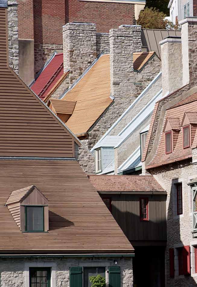
6 A Visual Exploration of Quebec City This book is the second in a series of four volumes that will provide a visual exploration of Quebec City, its history and its architecture. While the first volume, Quebec, World Heritage City, focused on the upper town, this one, Quebec, Birthplace of New France, takes us down to the lower town, where the city began early in the 17 th century with the establishment of a little trading post by the shore of the St. Lawrence River. The evolution of the lower town has always been tied to the rising and falling fortunes of Quebec as a maritime city. Over the centuries, the needs of the port determined not only the size and scale of the buildings in the sector, but even the amount of land available for construction. A brief outline of the history of each major location leads to a step-by-step exploration, in which general exterior and interior views are followed by photographs of selected objects, symbols and architectural elements. Texts have been kept deliberately short in order to provide as much space as possible for historic maps, images and, especially, Luc-Antoine Couturier s remarkable photographs. As we will see, a wide variety of historic buildings and structures have survived in the lower town. Evidence of Quebec s evolution as a port city remains visible at almost every corner, waiting to be discovered by the observant eye. It is a story that is told in brick and stone. 4 Extrait de la publication

7 Extrait de la publication

8 Extrait de la publication

9

10 Quebec Birthplace of New france The destiny of Quebec, founded by French explorer Samuel de Champlain in 1608, has always been tied to the city s remarkable strategic location. The Key to the Continent, Quebec is situated at the head of the St. Lawrence estuary, where the river suddenly narrows to a width of only one kilometre. Here, from the natural fortress of Cap-aux-Diamants, 17 th -century cannons could bar the passage of enemy ships. At first a small trading post, Quebec became the capital of New France, a fortress city, commanding the gateway between the Atlantic World and the interior of the continent. Champlain s Trading Post Samuel de Champlain first sailed up the St. Lawrence estuary as a member of a French expedition in At Tadoussac, where the Saguenay River enters the St. Lawrence, the explorers met with the Innu, a nomadic Algonquin-speaking people who claimed control of the region. The Innu invited the French to join them in a commercial and military alliance. In return for taking up arms with the Innu against their enemies the Iroquois, the French were given permission to set up a trading post further inland. In 1608, Champlain chose a site on the shore of the St. Lawrence River known as Quebec, a name that has its origin with a word in an Algonquin language meaning where the river narrows. By establishing themselves at this natural control point Champlain and his men hoped to be able to stop rival Basque and the Dutch fur traders from having access to the continental interior. Moreover, by joining forces with the Innu, the French would be able to benefit from 8 Introduction Extrait de la publication

11 their trading alliances with other Amerindian peoples further inland: Algonquian-speaking groups and Hurons, whose trade routes along the rivers led to the richest sources of furs. During their first years here, Champlain and his men chose to leave their large ships at Tadoussac. Having little knowledge of the St. Lawrence River, which can be extremely difficult to navigate, they travelled up the estuary to Quebec in smaller, shallow-draught boats. By the 1630s, however, French transatlantic ships were sailing inland all the way to Quebec. Beyond that point the river became too difficult to navigate. The large ships were thus obliged to stop at Quebec to unload their cargoes. Gateway to a Continent In 1663, Louis XIV chose the strategic site of Quebec to establish the capital of New France. This fortified city and inland seaport - hundreds of kilometres from the Atlantic would serve as a control point between the Atlantic World and the vast network of navigable rivers and lakes that would become the lifeblood of the French empire in North America. The basin before Quebec City provided water deep enough for the largest warships and merchant vessels to safely drop anchor. Beyond Quebec, smaller, shallow draught-boats were able to navigate upriver until their passage was blocked at Montreal by the Lachine rapids. Travel beyond that point was easiest by birch-bark canoe. French expansion along the St. Lawrence, to the Ottawa River and the Great Lakes, then down the Mississippi to the Gulf of Mexico has been compared to the growth of the branches of a tree. Forts and trading posts were established along the main rivers and then their principal tributaries, providing access ever deeper into the hinterland. Many North American cities that we think of today as being English, began as French forts and trading posts: Fort Toronto is now Toronto, Ontario; Fort Frontenac is now Kingston, Ontario; Détroit is now Detroit, Michigan; and La Nouvelle Orléans is now New Orleans, Louisiana. Introduction 9


12 At first Quebec s little lower town was confined to the area where the Place Royale sector is today. Elsewhere, the shore was submerged at high tide. In order to provide more land surface for construction, the mudflats shown in this 18th-century map were gradually covered over. By the end of the 19th century, the lower town had doubled in size. Contrasting Patterns of Settlement In contrast to the French, who had penetrated deep into the North American interior by the late 1600s, their principal competitors, the English, unable to expand into the West because they were blocked by New France, remained hemmed in along a narrow band of land between the Atlantic Ocean and the Appalachian Mountains. But while the English territories along the Atlantic seaboard did not allow much room for expansion, they did offer some important advantages. With ice-free seaports providing access to the Atlantic twelve months a year, and rich land for agriculture, the English population grew rapidly. The first English settlement, Jamestown (founded in 1607, one year before Quebec City), soon developed a thriving economy based on the export of tobacco. But large-scale agriculture quickly brought the English into conflict with the native peoples, leading to the first of a long series of bloody confrontations that would characterize English expansion along the North American frontier. Alliances with the Native Peoples: the Key to French Power The French, on the other hand, were much more interested in doing business with the native peoples than in taking over their lands in the interior regions. Most of the French population was concentrated in the St. Lawrence lowlands, which provided enough good agricultural land for the colony of New France, with its economy based mainly on the fur trade. Beyond the St. Lawrence Valley, in the vast territories that they referred to as le pays d en haut, the French never became numerous enough to impose their will on the native peoples. Instead, French policy sought, as often as possible, 10 Introduction Extrait de la publication

13 Native groups began to frequent the site of Quebec at least 3000 years ago. This early 19 th -century watercolour depicts a Micmac encampment on the south shore of the St. Lawrence, across the river from the city. to establish commercial and military alliances with the Amerindian nations. Indeed, the arrival of settlers in the continental interior would have been disastrous for the fur trade. Settlers would have cut down the trees and pushed the animals out of the way, just as they would have driven away the native hunters and trappers upon whom the French fur-traders depended for their livelihood. Pressures were mounting. By the mid 18 th century there were over one and a half million Englishspeaking people squeezed into the narrow band of land along the Atlantic coast, facing a French population of only about 60,000 to defend the entire continental interior. The English colonies, bursting at the seams, were becoming a serious threat, both to the inland empire of New France and to the native way of life. Recognizing this danger, an increasing number of native groups chose to actually invite the French to establish forts and trading posts on their territories to help serve as a barrier to English expansion. Without the help of the native peoples, it would have been impossible for the French, with such small numbers, to exert their influence over the interior of the continent for as long as they did. The Fall of New France Finally, however, New France was conquered by the English. In 1763, with the Treaty of Paris, the regions to the west of the Appalachians officially became English territory. Only decades later, following the American Revolution, hundreds of thousands of settlers would pour over the Appalachians and the native tribes would be swept away. It would only be a matter of time before the fur trade started to decline as well, as the natural environment on which it had depended began to disappear. Extrait de la publication Introduction 11
14 From Furs to Wood During the last decades of the 18 th century, the economy of Quebec City was still based on the fur trade and any changes in the port area tended to be slow and gradual. At the beginning of the 19 th century, however, international events would give new importance to the port of Quebec, leading to major transformations in the lower town. During the Napoleonic Wars, France cut England off from its traditional sources of wood in the Baltic region. The British then looked to the forests of Canada for new supplies, and the port of Quebec experienced a period of remarkable economic expansion. Fortunes were made here as Britain s need for wood, and wooden ships, transformed this little colonial city into one of the greatest ports in North America. Between 1806 and 1814, wood exports from the port of Quebec increased from 100,000 to 370,000 tonnes. And that was just the beginning. A comparison of the number of ships entering the port over the years can give us an idea of the extraordinary increase in activity in the port of Quebec during this period. While during the 18 th century a maximum of 80 transatlantic ships had visited the port each year, by 1811 the number had risen to 188 vessels. By the 1860s, between 1500 and 1700 ships were docking at Quebec City annually. Shipbuilding became big business. The number of ships constructed at Quebec rose from only 7 in the year 1800 to an average of 49 ships annually by One of the World s Great Ports By the middle of the 19 th century, Quebec City was doing more business than the port of Boston, and only New York City and New Orleans handled more tonnes of cargo. Quebec also became one of the most important ports for immigration from the British Isles to North America. Ships that were used to transport wood to Great Britain returned to Quebec City with a poverty stricken human ballast of English, Scottish and Irish immigrants hoping for a better life in the New World. By the 1830s an average of 30,000 people were disembarking in Quebec City annually. At the time of the great famine in Ireland, in 1847, almost 90,000 people landed on the docks of Quebec - this at a time when the permanent population of the city was only about 45,000! In that year, only New York City received more Irish immigrants than Quebec. Most of these immigrants continued on to other destinations further west, or in the United States, but the pressures on Quebec City must have been enormous. The upper town offered some room for expansion but the port area quickly became built up and solutions had to be found to compensate for the limited land surface that was available. Land reclamation efforts that had begun slowly during the French regime were accelerated to meet the needs of the expanding port, and by the end of the 19 th century the lower town had doubled in size. The Lower Town Evolves with the Port During the 17 th and 18 th centuries, minimal port facilities had been required to export furs and receive supplies for the small population of the colony. Indeed, until the end of the 17 th century the city did not have any docks at all. Large sailing ships were obliged to anchor out in deep water, where small boats went out to meet them to load and unload their cargoes. The little boats were simply beached on the shore. Wooden enclosures were constructed along the shoreline, to protect the labourers handling the cargoes from the waves of the St. Lawrence and the rising tide. At the turn of the 18 th century, these wooden structures were replaced by stone walls equipped with iron mooring rings to allow boats to tie up alongside at high tide. Although these stone quays served as docking facilities, they were not located in water deep enough to accommodate large vessels. In the early 19 th century, individual property owners began to construct long wooden wharves, projecting out into deep water so that big ships could dock directly beside them, even at low tide. These structures reached out into the river like a series of long fingers, with each wharf named after its owner: Grant s Wharf, Hunt s Wharf, etc. To provide storage space for the greater volume of cargo now being handled in the port, large warehouses, called stores, were constructed on the merchant s private wharves. A good example of one of these early stores is the Chillas warehouse, built in 1822, which is now part of the Auberge St. Antoine. Toward the end of the 19 th century much bigger warehouses were being constructed. On nearby Rue Saint Pierre other large buildings were constructed to house banks and other enterprises that served the needs of the growing port. During the first decades of the 19 th century, wellto-do merchants continued to reside in the port area, despite the increasing noise and activity. 12 Introduction


15 ABOVE: This romantic view, painted by George Heriot, depicts sleighs gliding over the frozen St. Charles River in 1805, with Quebec City in the background. BELOW: In the 19 th century it was no easy task to transport passengers and the mail over the icy waters of the St. Lawrence River. Today, an ice canoe race, held each year during the Quebec Winter Carnival, evokes the days when this strenuous activity was a necessity rather than a sport. Introduction 13

16 However, when in the 1830s and 1840s immigrants arrived bringing cholera and typhus which killed thousands of local citizens, the merchants began to move away from the lower town. Many established themselves in the upper town, or built villas in the countryside, to move their families as far as possible from the port, where deadly diseases arrived with the ships. This was the beginning of a gradual reorganization of the city into business, manufacturing and residential districts. The Seasons, the Winds and the Tides In the days of sail, almost every aspect of life in Quebec was affected in some way by the town s relationship with the water. Visitors arrived by ship, as did correspondence and news from afar. Most people depended on the river for their employment. They found jobs in the fur trade, shipbuilding, the timber trade and the many other businesses related to the life of the port. Many activities had to be scheduled in relation to the 14 Introduction Extrait de la publication

17 realities of river life - the seasons, the winds and the tides. For example, sailing vessels had to time their arrivals and departures to take advantage of favourable winds. They used the rising tide to go inland and the falling tide to head out to sea. Farmers travelled by boat to deliver their produce and firewood to riverside markets, such as the Marché Champlain, seen in this photograph (below), taken around Animals were slaughtered on the Island of Orleans at the beginning of winter, so that the frozen meat could be delivered to market by sleigh over the frozen river, via the ice bridge. The river was shallow enough between the island and the north shore to ensure that it would freeze solid each winter. In front of the city, however, the St. Lawrence is much deeper and an ice bridge could only form when the weather was particularly cold. When the river was not completely frozen, boatmen hired their services to transport passengers and goods across the river - over and between the moving ice floes - no easy undertaking (see page 13). In ways that are hard for us to imagine today, Quebec was truly a maritime city. Extrait de la publication


18 Decline... and Renaissance Quebec s time of prosperity and expansion as a great 19 th century port city, however, was to be short-lived. By mid-century, a shipping channel had been dug in the St. Lawrence, deep enough to allow the passage of transatlantic vessels all the way to Montreal. Quebec thus lost its exclusive status as a great inland seaport linking the Atlantic Ocean with the western interior. A new era of iron, steel and steam sounded the death knell of the age of sail. Steam-powered vessels could now navigate the shipping channel up the St. Lawrence to Montreal much more easily than sailing ships, which were dependent on the changing winds. Railways now made it possible to bypass the ice-filled river in wintertime, connecting Montreal with an ice-free port in Portland Maine, while the port of Quebec was stuck in the ice. British preferential tariffs that had protected the timber trade were abolished and wood exports from the port of Quebec plummeted. Then, when the British began to build metal ships at home, the market for the wooden ships constructed at Quebec collapsed completely. By the turn of the century, many workers who had lost their jobs in the port were looking for new employment in the factories of the St. Roch district or had left Quebec City altogether to seek work. Great efforts would be required to revive the fortunes of Quebec s port. The harbour was dredged and more deep-water docking facilities were constructed at the mouth of the St. Charles River, where a grain terminal was established by the Bassin Louise. Much of the development, however, 16 Introduction Extrait de la publication


19 would take place far from the original lower town, as the port expanded along the shoreline to Anseau-Foulon in the 1930s, and on the Battures de Beauport in the 1960s. As a result, the old port and business sectors were gradually abandoned and many buildings in the lower town were demolished or left to deteriorate. With cars and highways dominating daily life, and access to the dock areas forbidden, most local citizens lost touch with their maritime heritage. Then, in 1984, the waterfront was opened up to the public, with fine brick-paved promenades beside new deep-water docking facilities, where cruise ship passengers could step out directly into Quebec s historic waterfront sector. In the years that followed, the lower town experienced a renaissance, with the opening of the Musée de la civilisation, in 1988, the conversion of old warehouses for residential use, and the establishment of fine boutique hotels, shops and restaurants. The port as a whole, now accessible in winter thanks to ice-breakers, has undergone a renaissance as well. Today, as vessels become ever larger, Quebec s natural deep-water port offers considerable advantages once more. With expanded facilities able to accommodate Panamax and even Capesize vessels, which can carry cargoes of as much as 150,000 tonnes, Quebec City has been able to reaffirm its traditional role as a great inland seaport, providing a deepwater connection to the Great Lakes and the interior of North America. Extrait de la publication Introduction 17

20 Old Post Office An imposing edifice The old Post Office is one of the most imposing buildings in Quebec s historic district. Constructed in 1871 according to the plans of architect Pierre Gauvreau, then enlarged in 1913, the Post Office was re-named in 1984 to honour the memory of one of the city s most distinguished citizens, Louis S. St. Laurent, prime minister of Canada from 1949 to Although the building no longer serves as the city s central post office, it still provides postal services for customers in Quebec s upper town. Today, most of the build- 18 Old Post Office

21 ing is occupied by the regional offices of Parks Canada. The 1913 enlargement, which greatly enhanced the dignity of the edifice, is crowned by a monumental copper-roofed dome, seen here on a winter s night from a room in the nearby Chateau Frontenac hotel. The same enlargement included a new façade, graced by massive columns and a triangular pediment, facing Côte de la Montagne. Although somewhat difficult to see from the streets below, the new additions made the building very impressive when seen from a distance especially for visitors arriving by ship (see page 21). Prior to the construction of the Post Office building in 1871, the site was occupied by one of the city s largest 18 th -century houses. Known as le Chien d Or, the old stone house (see next page) had first served as a private residence, then as an inn, as a Masonic Hall and as a post office, before being finally demolished to make way for the present edifice. Extrait de la publication

22 Extrait de la publication
FUR TRADE PHASE 1 The Early Fur Trade A Glimpse of the Early Fur Trade
 FUR TRADE PHASE 1 The Early Fur Trade 1500-1603 The cod fishery began the early fur trade. First Nations such as the Mi kmaq began to trade with Europeans coming to fish cod off the east coast. The British
The History of Railways into Grimsby
 The History of Railways into Grimsby Grimsby at the beginning of the 19 th C was no more than a small east coast market town with a small dock, which suffered from silting problems. The population was
Imagine that you are. The Story of Etienne Brûlé Adventurer - Coureur des Bois
 The Story of Etienne Brûlé Adventurer - Coureur des Bois your family and friends for a long time. The ship you will travel on is made of wood and has no engines. It depends on the wind to blow it to its
AMERIGO VESPUCCI ( )
") AMERIGO VESPUCCI (1451-1512) Amerigo Vespucci was born in Italy in 1451. Vespucci went on several expeditions to South America. In 1501, he sailed in service to the King of Portugal. This was his third
AMERIGO VESPUCCI (1451-1512) Amerigo Vespucci was born in Italy in 1451. Vespucci went on several expeditions to South America. In 1501, he sailed in service to the King of Portugal. This was his third
Gayaza High School Geography Department
 THE DEVELOPMENT OF THE SAINT LAWRENCE SEAWAY This is an inland water way partly artificially constructed from the Gulf of St. Lawrence to the Western end of Lake Superior. It covers a distance of 3,800
Chapter 4 Competition For The Fur Trade
 Chapter 4 Competition For The Fur Trade BIG IDEA How did the various people in North America work together in the fur trade and compete to control it? Vocabulary 1.Barter The exchange of goods for other
Lesson Resource Kit: Building the Rideau Canal
 Lesson Resource Kit: Building the Rideau Canal Grade 7: 1800 1850: Conflict and Challenges Lock, Blockhouse at the Narrows, Rideau Lake - the first descent from Summit towards Bytown, painted by Thomas
BUILDING MONTRÉAL BEFORE YOUR VISIT 1/2. Competencies developed: Materials required:
 www.lucbouvrette.com Marc-Antoine Zouéki, www.zoueki.com BUILDING MONTRÉAL So you re coming to Pointe-à-Callière, Montréal Archaeology and History Complex. Our Building Montréal exhibition will take you
Adapting and Developing Hands Free Mooring for Navigation Locks Speaker: Benoit Nolet
 Adapting and Developing Hands Free Mooring for Navigation Locks Speaker: Benoit Nolet The Great Lakes St. Lawrence Seaway System A gateway to the heartland of North America 3,700 km (2,300 m) marine highway
THE EARLY FUR TRADE. Coureur de Bois & The Exploration of Canada
 THE EARLY FUR TRADE Coureur de Bois & The Exploration of Canada BIG QUESTIONS What was traded in the Fur Trade? Who benefitted from it? How did the Fur Trade help expand New France? FURS: THE REASON FOR
A Nautical View of Vermont. Christy Leonard LS07055
 A Nautical View of Vermont Christy Leonard LS07055 The importance of boating in the Champlain Valley grew during French and British military conflicts over waterways. Vermont waterways were important because
The Chesapeake Bay as an Estuary: An introduction. Istvan A. Urcuyo Gettysburg College
 The Chesapeake Bay as an Estuary: An introduction. Istvan A. Urcuyo Gettysburg College The Chesapeake Bay -Native Americans resided on its shores since 8000 B.C. The Chesapeake Bay -Original Native American
For all persons who took part of this succesfull event
 Défi International des Jeunes Marins September 02 2008 RENDEZ-VOUS DE YOLES DU 400e DE QUÉBEC, JULY 24-31 FINAL REPORT For all persons who took part of this succesfull event Fourteen gigs in total participated
2 History & Geography. 2.1 Geography The Delmarva Peninsula
 2 History & Geography 2.1 Geography 2.1.1 The Delmarva Peninsula The Delmarva Peninsula is a large peninsula on the east coast that contains land within the three states of Delaware, Maryland, and Virginia.
The following resources were used in writing the texts:
 Lesson Plans CANADA Vancouver, Canada s West Coast City (Level 2) The purpose of LessonPlansCanada is to provide well-structured and interesting reading texts and other classroom activities. These lesson
Lieu historique national du Canada du Commerce-de-la-Fourrure-à-Lachine Fur Trade at Lachine National Historic Site of Canada
 Lieu historique national du Canada du Commerce-de-la-Fourrure-à-Lachine Fur Trade at Lachine National Historic Site of Canada Re: To follow-up on your visit Teachers, It was a pleasure to receive you at
Physical Features, Where People Live, & How They Trade
 Physical Features, Where People Live, & How They Trade 5 large freshwater lakes in central North America HOMES (Huron, Ontario, Michigan, Erie, Superior) Serve as the industrial heartland of the continent
The French Say No. Part Two:
 The French Say No Part Two: 1713-1758 The Treaty of Utrecht The city of Utrecht, Netherlands (in Europe) was where the Treaty was signed by all three nations. Right: the Treaty of Peace between Spain and
Answers to Ontario Quiz
 Answers to Ontario Quiz Test Your Knowledge What do you remember from your review of the Ontario section of the E-Atlas? 1. Ontario is one of the biggest contributors to Canada s gross domestic product
PRESTAMP AND STAMPLESS COVERS TO, FROM, AND THROUGH BRITISH NORTH AMERICA
 PRESTAMP AND STAMPLESS COVERS TO, FROM, AND THROUGH BRITISH NORTH AMERICA 1685 1865 A selection from a collection of covers to, through, and from what is now Canada showing unusual routes, rates, destinations,
Super-trawlers: Destructive or Sustainable? Public Hearing in the European Parliament 9 October 2017
 Super-trawlers: Destructive or Sustainable? Public Hearing in the European Parliament 9 October 2017 Brian O Riordan Deputy Director, Low Impact Fishers of Europe Super-trawlers: a perverse product of
Boone County Conservation District
 Les Voyageurs Boone County Conservation District Thank you for scheduling a Fur Trade program! This packet has been developed to provide pre or post activities in conjunction with your visit. Below are
Canada A People s History: Battle For A Continent. Battle For A Continent
 Canada A People s History: Battle For A Continent Battle For A Continent British America is a ribbon of fourteen prosperous colonies stretching from Halifax to Savannah. Its cities are thriving, its population
A Suggested Route Large Print
 National Maritime Museum Cornwall A Suggested Route Large Print This Large Print Guide was produced by the Heritage Ability team, part of Living Options Devon (charity number 1102489) www.heritageability.org
Climate Change Action Plan: Transportation Sector Discussion Paper: Cycling
 Climate Change Action Plan: Transportation Sector Discussion Paper: Cycling ontario.ca/climatechange Contents 1. Minister of Transportation s message... 3 2. Introduction... 5 3. Sector Overview and Support
RUPERTSLAND to and from GREAT BRITAIN 1822 and 1837
 RUPERTSLAND to and from GREAT BRITAIN 1822 and 1837 1822 Scotland to York Factory Via Hudson s Bay House, London With the super scripture Y F for York Factory applied in London. 1837 York Factory on Hudson
Wisconsin s Fur Trade Impact Definition: Impact on Native people Impact on Environment Impact on Economy
 Wisconsin s Fur Trade Impact Definition: Important early business involving Native people trading beaver, mink, and otter pelts to European traders for blankets, brass cooking pots, metal axes, woolen
Binder Page Name Per Exploring New York
 Binder Page Name Per Exploring New York Date This map shows the modern state of New York, and other surrounding states. 1. Put a dot on the map where Buffalo is located. Label it Buffalo. 2. Label the
Rendezvous at Michilimackinac
 SCENE I Rendezvous at Michilimackinac Setting: A hunting camp on the St. Peter s River (Now the Minnesota River) Time: Late winter, 1775 Characters: Running Deer (An Ojibwa hunter) Whispering Sky (His
Summer Visitors Play in Martha's Vineyard and Nantucket
 Summer Visitors Play in Martha's Vineyard and Nantucket Welcome to This Is America with VOA Learning English. This week on our program, we tell you about two islands in Massachusetts, in the New England
Making a Living in the Nineteenth Century
 Making a Living in the Nineteenth Century Introduction Key Words for this chapter: Bank Fishery Consumer Economy Inshore Fishery Labrador Fishery Seal Fishery Subsistence Economy Truck System www.huffingtonpost.ca
Tidal energy is produced by the surge of ocean waters during the rise and fall of tides. Tidal energy is a renewable source of energy.
 Encyclopedic Entry For Educator tidal energy For the complete encyclopedic entry with media resources, visit: http://www.connectenergyed.org/education/encyclopedia/tidal-energy/ Tidal energy is produced
Have homework out for me to check Need notes from yesterday Teaching Point: Understanding the terms of MAIN IDEA
 1. Unpack/ Use the Restroom 2. Sharpen 2 pencils 3. Write down homework 4. Show me your agenda 5. GET ALL READING MATERIALS 6. Work on Math Muscle 7. Work on i-ready when finished 8. Global Read Aloud
CALL FOR OFFERS - MONDAY, AUG. 31 st Redevelopment Opportunity PRIME ATLANTIC BEACH CORNER 3 BLOCKS TO THE OCEAN
 CALL FOR OFFERS - MONDAY, AUG. 31 st Redevelopment Opportunity PRIME ATLANTIC BEACH CORNER 3 BLOCKS TO THE OCEAN 104 ATLANTIC BEACH CAUSEWAY ATLANTIC BEACH, NORTH CAROLINA, 28512 Morehead City Atlantic
GRADE 7 SOCIAL STUDIES CHAPTER 2 ECONOMIES IN HISTORY
 GRADE 7 SOCIAL STUDIES CHAPTER 2 ECONOMIES IN HISTORY CHAPTER INTRODUCTION Throughout history, every society in the world has had some kind of economic system. The purpose of an economic system is to answer
2. Context. Existing framework. The context. The challenge. Transport Strategy
 Transport Strategy Providing quality connections Contents 1. Introduction 2. Context 3. Long-term direction 4. Three-year priorities 5. Strategy tree Wellington City Council July 2006 1. Introduction Wellington
Boat Making Elementary
 Boat Making Elementary Historic Homes Gardens Artifacts Costumed Crafts People Boat Tours Gift Shop Restaurant Standards Standards as developed by the Louisiana Department of Education. Available online
Maritime Exploration THE EARLY MODERN WORLD ( )
") Maritime Exploration THE EARLY MODERN WORLD (1450 1750) An important theme of 1450 1750 (The Early Modern World) will be the effects of European exploration on the world. However, there were maritime expansions
Maritime Exploration THE EARLY MODERN WORLD (1450 1750) An important theme of 1450 1750 (The Early Modern World) will be the effects of European exploration on the world. However, there were maritime expansions
The Oyster in Oyster Bay: Glaciers Set the Table
 The in Bay: Glaciers Set the Table In cooperation with NYS Department of Environmental Conservation Bay Long Island was created about 15,000 years ago when the last of the glaciers melted leaving behind
14 NOISE AND VIBRATION
 14 NOISE AND VIBRATION 14.1 EXISTING ENVIRONMENT 14.1.1 The noise environment within Poole Harbour is generally characterised by low to medium noise levels depending on location. For example, certain areas
One of the interesting aspects of capturing a perfect reflection is that the picture is
 St. Lawrence Reverie The dreamlike beauty of the 1000 Islands. PHOTOS & TEXT BY IAN CORISTINE One of the interesting aspects of capturing a perfect reflection is that the picture is equally viewable right
Economic Transformation and Recovery in Hong Kong and Singapore
 School of Economics and Finance, The University of Hong Kong Presentation given at the followings : - Zonta Club 1999 Accountancy Conference, Vocational Training Council on October 8, 1999 The Society
Sekondi Takoradi, Twin Cities 1
 1030 Asante Empire & Andikra Symbols Capt. Daley's Sea Stories M/V Ken C Tamblyn Ghana, Africa 23 October 2010 Sekondi Takoradi, Twin Cities 1 Sekondi-Takoradi, population 335,000, is the capital of the
Chapter Three. European Exploration and Colonization
 Canadian History Chapter Three European Exploration and Colonization CHAPTER 3 Outcomes Students will Learn how First Peoples and Europeans interacted in the Northwest, and what the results were The Rise
The History of Commercial Fishing in Prince Edward Island
 The Open Suitcase Series Program Description The History of Commercial Fishing in Prince Edward Island This program explores the history of the second largest industry on Prince Edward Island and its origins,
Breakwater Wharf Encasement Hant s Harbour, Newfoundland
 ABSTRACT Breakwater Wharf Encasement Hant s Harbour, Newfoundland Jamie Downey Memorial University of Newfoundland St. John's, NL, Canada jdowney@mun.ca Hant s Harbour, a small fishing community located
Student Reading 6.4: Exploring the Relationship between European Settlers and. Historic American Indians
 Student Reading 6.4: Exploring the Relationship between European Settlers and Historic American Indians In the 1600s the first white men came to Ohio. These men were explorers and fur traders. Some came
Hydrographic Surveying Methods, Applications and Uses
 Definition: Hydrographic Surveying Methods, Applications and Uses It is the branch of surveying which deals with any body of still or running water such as a lake, harbor, stream or river. Hydrographic
Piecing Together History: Chinese Barges in the Song Dynasty. Archaeological analysis relies upon evidence-based speculation as definitive proof is
 Rebecca Gonzalez-Rivas Anthropology 1218 Museum Project Part II Due: March 11, 2016 Piecing Together History: Chinese Barges in the Song Dynasty Archaeological analysis relies upon evidence-based speculation
Lesson 2 Fur. Preparation. Introduction. World History for Us All Big Era 6 Landscape 4
 Fur Preparation Have you ever thought about where your favorite hat comes from? Was it made in one place? How did it get from where it was made to your favorite store? What kind of profit do hat makers
STUDY GUIDE. The Land. Physical Geography of Europe. Chapter 11, Section 1. Terms to Know DRAWING FROM EXPERIENCE ORGANIZING YOUR THOUGHTS
 For use with textbook pages 271 276. The Land Terms to Know dikes Large banks of earth and stone that hold back water (page 272) polder Drained area of land (page 272) glaciation The process in which glaciers
SEPTEMBER 23-29, 2018 for 7 days 6 NIGHTS
 CAPE COD, PLYMOUTH, BOSTON, MASSACHUSETTS & PORTLAND, BOOTHBAY HARBOR, MAINE SEPTEMBER 23-29, 2018 for 7 days 6 NIGHTS Featuring a Whale Watch Cruise, City Tour of Boston, and a Boothbay Harbor Cruise
FOREWORD HELD BY SIR CARL DECALUWE FOLLOWING THE INTERNATIONAL FIELD EXERCISE MIRG-EX THAT TOOK PLACE ON TUESDAY THE 11 AND THE 12 OF OCTOBER 2016
 FOREWORD HELD BY SIR CARL DECALUWE FOLLOWING THE INTERNATIONAL FIELD EXERCISE MIRG-EX THAT TOOK PLACE ON TUESDAY THE 11 AND THE 12 OF OCTOBER 2016 Bruges, November 23th 2016 Dear everyone present here
National Maritime Center
 National Maritime Center Providing Credentials to Mariners (Sample Examination) Page 1 of 8 Choose the best answer to the following Multiple Choice Questions. 1. Assume that your vessel has just entered
South Shore. Jacques-Cartier. Bridge. De la Concorde. Bridge. Olympic Basin START & FINISH. Pavillon des activités nautiques.
 De la Concorde Bridge Casino de Montréal Jean-Doré Beach Olympic Basin Old-Port of Montréal Jacques-Cartier Pier 2 START & FINISH 1 Jacques-Cartier Bridge 6 4 5 3 South Shore 1 2 3 4 5 6 La Ronde Environment
Student Reading 6.1: Ohio s Historic American Indians. were known as the Historic Indians because they lived in the period following
 Student Reading 6.1: Ohio s Historic American Indians The American Indian groups living in Ohio, during the 1600s and 1700s were known as the Historic Indians because they lived in the period following
Controlling Coastal erosion
 Controlling Coastal erosion Coastal Erosion Rates in the U.S. Coastal Erosion and Stabilization Economic pressures demanding the stabilization of beaches and coastlines are immense Coastal Erosion and
Lincolnshire Walks. Grainthorpe. Three circular walks of 2 ¾, 9 and 9 ½ km (1 ¾, 5 ½ and 6 miles)
") Lincolnshire Walks Grainthorpe Three circular walks of ¾, 9 and 9 ½ km (1 ¾, ½ and 6 miles) Introduction Explore the coastal marshes, arable hinterland, Louth Navigation canal and the village of Grainthorpe
Lincolnshire Walks Grainthorpe Three circular walks of ¾, 9 and 9 ½ km (1 ¾, ½ and 6 miles) Introduction Explore the coastal marshes, arable hinterland, Louth Navigation canal and the village of Grainthorpe
Unit 2: United States Expansion Part 3: Oregon Country" I. The Lure of Oregon. II. Competing Claims. Name: Period:
 Unit 2: United States Expansion Part 3: Oregon Country" Name: Period: I. The Lure of Oregon A. Since the early 1800 s Americans had heard of the. While settlers filled in lands between the Mountains and
History of Sagadahoc County: Nine Towns and One City
 History of Sagadahoc County: Nine Towns and One City The long and rich history of Sagadahoc County and its ten communities, a history still portrayed in current structures, road patterns and land uses,
Background: If people did not explore the world, we would not know as much as we do now. Background evidence #1 Back then, spices were very important.
 Student D CBEAR Outline ***(Hint: your claim should be able to be proved with research, evidence, and academic thinking.) Claim: During the 1400s people liked to explore the world. ***(Hint: What do you
Shipwrecks & Lifesaving Shipwrecks & Rescues
 Shipwrecks & Lifesaving Shipwrecks & Rescues The primary function of the Twin Lights was to assist mariners in navigation as they approached the treacherous coastline south of New York Harbor. Although
TRANSPORTATION NATIVE AMERICAN RHYMES CONTENTS
 NATIVE AMERICAN RHYMES TRANSPORTATION CONTENTS Overview 1 Travois 2 Sleds 3 Toboggan 4 Kayaks and Umiaks 5 Bark Canoes 6 Dugouts 7 Snowshoes 8 Plank Boats 9 Bullboats 10 Balsa Boats 11 WordSearch Puzzle
Parts and Pieces The Story of Chicago and Lake Michigan
 Parts and Pieces The Story of Chicago and Lake Michigan You may draw pictures to show what each part of this history might have looked like. Draw your pictures next to the words. You also may cut these
WHAT IS A TSUNAMI? happens.nz. Long or Strong GET GONE TSUNAMI 101
 WHAT IS A TSUNAMI? A tsunami is a series of powerful waves with strong currents. They are mostly caused by underwater or coastal earthquakes, and sometimes by underwater landslides or volcanic eruptions.
THE HISTORIC PORT OF SHELBURNE
 Welcome to THE HISTORIC PORT OF SHELBURNE portshelburne.com 1 WELCOME TO THE HISTORIC PORT OF SHELBURNE Historic Dock Street, Shelburne Photo credit: Chris Abbott A MESSAGE FROM THE MAYOR Welcome to Shelburne
Surfing Tourism Destination Feasibility Study, Kincardine, Ontario
 Surfing Tourism Destination Feasibility Study, Kincardine, Ontario Prepared for: Regional Tourism Organization 7 and the February 24, 2014 EXECUTIVE SUMMARY With support from the Regional Tourism Organization
170 points. 38 points In your textbook, read about modern oceanography. For each item write the word that meets the description.
 Ch 15 Earth s Oceans SECTION 15.1 An Overview of Oceans 38 points In your textbook, read about modern oceanography. For each item write the word that meets the description. (5 points) 1. German research
The Port of Virginia and Economic Development
 The Port of Virginia and Economic Development RODNEY W. OLIVER, CHIEF FINANCIAL OFFICER VIRGINIA PORT AUTHORITY 1 EAST COAST / WEST TRADE BALANCE 2 AN IMPORT PARADIGM SHIFT The West Coast has traditionally
American Indian Heritage Month
 American Indian Heritage Month Both Governor Gary Herbert and President Barack Obama have issued declarations announcing November to be observed as American Indian Heritage Month. American Indian Heritage
How much do you know about Scottish castles? TAKE THIS QUIZ AND FIND OUT! COMPLETE THE SENTENCES WITH THE PASSIVE FORMS OF THE VERBS IN BRACKETS.
 Scottish Castles This work is a result of the project titled Increasing ELT Effectiveness accepted by Foundation for the Development of the Education System (FRSE) Project number: 2014-1-PL01-KA101-000712
Native Americans Are Essential to the History of the United States
 Native Americans Are Essential to the History of the United States Welcome to the Making of a Nation American history in VOA Special English. I m Steve Ember. This week in our series, we look at the history
The magazine of the Furness Vale Boat Club. February 2017
 Reflections The magazine of the Furness Vale Boat Club February 2017 Introduction. Welcome to the February 2017 edition of Reflections the periodical magazine of the Furness Vale Boat Club. In this article
Kingston is a critical component of maritime commerce in the Hudson River Valley and the state of New York because
 Thesis-Lauren Project Logo-LaurenLauren Place-Lauren Brief History of Kingston -Allie Natural Ice Industry-Allie Rondout Creek: Lighthouses -Maryellen Rondout Creek: Industries -Maryellen Fishing-Maryellen
Fort Hancock Sailing Center
 Response to the National Parks Service Request for Expressions of Interest to Redevelop Historic Structures at Fort Hancock in the Sandy Hook Unit of Gateway National Recreation Area Fort Hancock Sailing
31. Rosses Point Mini-Plan
 County Development Plan 2017-2023 Volume 2, Chapter 31 Rosses Point Mini-Plan 31. Rosses Point Mini-Plan Village profile Rosses Point is a coastal settlement located approximately 8 km north-west of Sligo
Public Spaces Planning Policies and the Effects on Pedestrian Mobility in a Metropolis City; the Case Study of Tehran, Iran
 Public Spaces Planning Policies and the Effects on Pedestrian Mobility in a Metropolis City; the Case Study of Tehran, Iran Ehsan Ranjbar Assistant Professor of Urban Design, Tarbiat Modares University,
Chicago River. My Chicago. Vocabulary INSTRUCTOR NOTE
 Chicago River 5 INSTRUCTOR NOTE Ask students to locate the blue stripes on their Chicago flag. The stripes represent Lake Michigan and the north and south branches of the Chicago River. The Chicago River
The Mobile Mardi Gras Trail
 The Mobile Mardi Gras Trail is a non-profit initiative, created to increase public access to Mobile's history and the arts. The Mardi Gras Trail a series of prominent historic markers which tell Mobile
STUDENTS BRIEF. The Scottish Fishing Industry: A Survey of the Catching Sector
 STUDENTS BRIEF The Scottish Fishing Industry: A Survey of the Catching Sector The Scottish Fishing Industry is divided into two main sectors: catching and processing. The catching sector covers the activities
ROUND ABOUT NEW ZEALAND.
 ROUND ABOUT NEW ZEALAND. CHAPTER I. MELBOURNE TO DUNEDIN. EARLY in 1883 I left Melbourne for the " promised land" of New Zealand. From various reasons I had long made a point of acquiring all the information
Your web browser (Safari 7) is out of date. For more security, comfort and the best experience on this site: Update your browser Ignore
 is out of date. For more security, comfort and the best experience on this site: Update your browser Ignore") Your web browser (Safari 7) is out of date. For more security, comfort and the best experience on this site: Update your browser Ignore TIDAL BO RE For the complete encyclopedic entry with media resources,
Your web browser (Safari 7) is out of date. For more security, comfort and the best experience on this site: Update your browser Ignore TIDAL BO RE For the complete encyclopedic entry with media resources,
NYS Coastal Waters. Water Resources of NYS: THE NATURE of the COASTAL ZONE. NYS Coastal Waters. NYS Coastal Atlas. Coastal Zone Management 10/10/2014
 Water Resources of NYS: THE NATURE of the COASTAL ZONE NYS Coastal Waters NYS is the only state to border the Atlantic Ocean and the Great Lakes (Lakes Erie and Ontario). Great Lakes shoreline: 577 miles
Introducing the Great Lakes
 Introducing the Great Lakes Just a few years ago, geologically speaking, a glacier passed this way, and that's why the Midwest has the Great Lakes. Size The Great Lakes and their connecting channels form
A Brief Introduction to the Great Lakes. Geographical History. Lake Ontario. Lake Erie
 A Brief Introduction to the Great Lakes Geographical History The Great Lakes were formed during the last ice age, roughly 10,000 years ago The Glaciers carved the lakes out of an existing basin, and when
Comments The Plan for Port Whitby
 Comments The Plan for Port Whitby April 24th, 2013 Community Meeting #2 Summary Report Prepared by GLPi April 29th, 2013 1 Introduction The purpose of the Port Whitby Secondary Plan Update, Community Improvement
GIBRALTAR: TWINNED WITH CEUTA? 17 June 2004
 GIBRALTAR: TWINNED WITH CEUTA? FAST FACTS Urbanized Area* Population 30,000 Urbanized Land Area: Square Miles 2.5 Urbanized Land Area: Square Kilometers 6.4 Population per Square Mile 12,000 Population
Regional Profile Ebbw Vale & Blaenau Gwent
 Regional Profile Ebbw Vale & Blaenau Gwent Content Overview of Ebbw Vale Economy of Ebbw Vale & Blaenau Gwent Workforce Skills Addressing Youth Unemployment Summary Ebbw Vale & Blaenau Gwent Overview of
Vitus Bering and the Idea of History
 Vitus Bering and the Idea of History Quick Review Why did they explore? Who were the Explorers? What made world wide exploration possible? Replica of the HMS Bark Endeavor, one of the ships Cook sailed
Section 11: The Medina Estuary
 Section 11: The Medina Estuary 9 1 8 2 3 Medina Valley (Stretch 11) 4 5 7 6 Introduction: The East Cowes area has no public footpaths, and the creation of a coastal path around the Medina would connect
Waterfront User Needs Assessment & Detailed Design RESPONSE TO COMMENTS
 Waterfront User Needs Assessment & Detailed Design RESPONSE TO COMMENTS Town of Cobourg Presentation to Council Monday July 3, 2018 4 PM 1 Response topics Opportunity to clarify and correct misinterpretations
Bezaisen: A Symbol of Feudal Era Japan. The Edo Period ( ) was a period of Japanese history characterized by strict
 was a period of Japanese history characterized by strict") Kathy Tran ANTHRO1218: Shipwrecks and Seafarers, Piracy and Plundering Bezaisen: A Symbol of Feudal Era Japan The Edo Period (1603-1868) was a period of Japanese history characterized by strict isolationist
Kathy Tran ANTHRO1218: Shipwrecks and Seafarers, Piracy and Plundering Bezaisen: A Symbol of Feudal Era Japan The Edo Period (1603-1868) was a period of Japanese history characterized by strict isolationist
Native Americans? Who are the. The Bering Strait. Activities Pack 8/7/2015
 Native Americans Activities Pack Who are the Native Americans? They likely came to North America across the Bering Strait when hunting animals. Can you tell where you live on the map? The Bering Strait
ARkAnsAs tennessee Primary Partner: Primary Partner: Habitat Work: Habitat Work:
 Eastern Elk initiative david STEPhENSON Elk in the East On foggy mornings when the chill of fall is in the air, distant elk bugles ring sparsely through the hills and valleys of the East. Each one tells
ISBA Summer Seminar CALAIS FRANCE. 18 th to 25 th August 2018
 ISBA Summer Seminar CALAIS FRANCE 18 th to 25 th August 2018 THE SITE Location On the Strait of Dover, Calais is situated in a privileged position in North-West Europe with an Eastern access to the Benelux
Protecting the Lost Colony of Roanoke with Innovative Shoreline Stabilization Solutions
 Protecting the Lost Colony of Roanoke with Innovative Shoreline Stabilization Solutions Matthew Starr, PG Jeff Tabar, PE, D.CE Corbitt Kerr, PhD, PE February 8, 2018 Agenda 1 Lost Colony History 2 Project
Journey of the River Arun Education and Learning Pack
 Journey of the River Arun Education and Learning Pack 0 Key Terms River Arun Ghylls (small streams) Tarrant Tristantonis Estuary Arundel Littlehampton St Leonards Forest Learning Objectives To learn where
HARBOR INFRASTRUCTURE INVENTORIES Marquette Harbor, Michigan
 HARBOR INFRASTRUCTURE INVENTORIES Marquette Harbor, Michigan Harbor Location: Marquette Harbor is located in Marquette Bay on the south shore of Lake Superior, 160 miles west of Sault Ste. Marie, MI and
The St. Lawrence Seaway--To Mid-Continent by Ocean Vessel
 Case Western Reserve Law Review Volume 11 Issue 1 1959 The St. Lawrence Seaway--To Mid-Continent by Ocean Vessel Lewis W. Britton Follow this and additional works at: http://scholarlycommons.law.case.edu/caselrev
CHAPTER 11.1 THE WORLD OCEAN MARINE BIOMES NOTES
 CHAPTER 11.1 THE WORLD OCEAN MARINE BIOMES NOTES 1. The world ocean can be divided into zones both and. The,, and zones that apply to large lakes also apply to the ocean. 2. In addition to the depth zones,