Arkansas River Corridor Access Plan
|
|
|
- Sophia Porter
- 6 years ago
- Views:
Transcription


1 Arkansas River Corridor Access Plan 1
2 ACKNOWLEDGEMENTS The Partnership members were: The Arkansas River Coalition Reno, Sedgwick, and Sumner Counties The cities of Hutchinson, South Hutchinson, Wichita, Derby, and Oxford Kansas Wildlife and Parks The Steering Committee provided guidance and leadership for the Partnership and directed the work of the Consultant Team. Steering Committee members were: Francis Schoepf Irene Hart Susan Erlenwein Janis Hellard Mike Lueck Paul Hiebert Larry Hoetmer Robert Mendoza Tom Lowry Ben Huie Ken McCloskey Reno County Commission Reno County Director of Community Development Sedgwick County Environmental Resources Director Sedgwick County Administrative Assistant for Economic Development Commission Sumner County Park Director City of Hutchinson Director Public Works City of South Hutchinson Parks and Recreation Department City of Wichita Director Public Works City of Derby Park Commissioner City of Oxford Arkansas River Coalition Kansas Wildlife and Parks The Consultant Team members that contributed to this work were from Applied Ecological Services and Patti Banks Associates: Thomas L. Huntzinger PE Stephen B. Rhoades LA Mark Andersen Laurie Brown Project Manager, Hydrologist Applied Ecological Services Planning/Design of Parks, Greenways and Trails Patti Banks Assoc. GIS, Spatial Analysis, Ecology Applied Ecological Services Community Planning, Ecology Patti Banks Assoc. 2
3 TABLE OF CONTENTS EXECUTIVE SUMMARY...7 INTRODUCTION...9 BACKGROUND AND HISTORY... 9 PLANNING PROCESS AND PUBLIC OUTREACH ESTABLISHING A RECREATIONAL ACCESS POINT SECTION 1. PARTNERSHIPS AND PUBLIC INVOLVEMENT INTRODUCTION PARTNERSHIPS and STUDY PROCESS PUBLIC INVOLVEMENT TECHNICAL WORKSHOP AND DISCUSSION SECTION 2. ACCESS POINT RECOMMENDATIONS INTRODUCTION STUDY PROCESS FINDINGS RECOMMENDATIONS IMPLEMENTATION OTHER ACCESS POINT OPPORTUNITIES SECTION 3. ACCESS POINTS AND AMENITIES INTRODUCTION ACCESS POINT DESIGN MAINTENANCE AND ENFORCEMENT SECTION 4. DAM OBSTRUCTIONS INTRODUCTION STUDY PROCESS SECTION 5. FLOATABLE CHARACTERISTICS INTRODUCTION STUDY PROCESS RESULTS SECTION 6. MANAGEMENT INTRODUCTION SAFETY FUNDAMENTALS BOUNDARIES AND LIABILITY SECTION 7. SUMMARY AND CONCLUSION APPENDIX A. PUBLIC MEETING COMMENT SUMMARY AND FACT SHEET APPENDIX B. EXISTING AND POTENTIAL ACCESS POINT DETAIL APPENDIX C. DAM OBSTRUCTION DETAIL APPENDIX D. ADDITIONAL STREAMFLOW AND FLOATABILITY DATA
4 FIGURES Figure 1.1 Public Meeting February 12-13, Figure 1.2 Public Meeting March 23-25, Figure 2.1 Site Selection process overview Figure 2.2 GIS Layer representing road rights-of way and Arkansas River right-of-way Figure 2.3 Arkansas River Access Point Locations Figure 3.1 Primary Access Point Figure 3.2 Secondary Access Point Figure 3.3 Primitive Access Point Figure 4.1 Dam obstruction location map Figure 4.2 The 21 st Street Bridge Figure 4.3 Opening at the 21 st Street Bridge Figure 4.4 Downstream from the Lincoln Street Bridge Figure 4.5 Opening at the Lincoln Street Bridge Figure 4.6 Drawing of weir notches Figure 4.7 Constructed chute and anchored obstacles Figure 4.8 Conceptual drawing and photo of constructed chute Figure 4.9 Constructed chute Figure 4.10 Kayaker in whitewater Figure 4.11 Photo of family paddling Figure 4.12 The Tubes Figure 5.1 Chart - Annual mean discharge Figure 5.2 Chart Daily Mean Flow Records from February 1997 to February Figure 5.3 Chart Water Depths for the Arkansas River at Hutchinson Figure 6.1 Photo of Debris lines Figure B.1 Existing access point Mile 816 4th St. Hutchinson Figure B.2 Existing access point Mile 811 Cary Park, Hutchinson Figure B.3 Looking downstream forward 21 st Bridge and dam Figure B.4 Proposed and Existing access points Mile st St Figure B.5 Existing access points Mile 763 Gander Mountain and Mile 762 Lincoln Street Figure B.6 Looking upstream towards the Lincoln Street Bridge Figure B.7 Existing access point Mile 758 Garvey Park Figure B.8 Access ramp at Garvey Park Figure B.9 Existing access points Mile st Street Wichita Figure B.10 Parking area at 71 st Street Access point Figure B.11 Access ramp at 71 st Street location Figure B.12 Proposed access ramp at Mile 750 West Washington Ave. Derby Figure B.13 Access point at West Washington Avenue in Derby Figure B.14 Access ramp at Cave Park in Oxford Figure B.15 Existing access point Mile 724 Cave Park, Oxford Figure B.16 Proposed access point Mile 826 Nickerson Brush Dump Figure B.17 Potential access point near K Figure B.18 Proposed access point Mile 824 Nickerson Road Figure B.19 Private pull off 69th Avenue near Nickerson Road
5 FIGURES continued Figure B.20 Proposed access point Mile 806 Eales Road Figure B.21 Potential access point Eales Road and Yoder Road Figure B.22 Proposed access points Mile st Street Figure B.23 Proposed access point Mile th Street/Clearwater Rd Figure B.24 Proposed access point Mile rd Street Figure B.25 Land without the Levee off 53rd Street Figure B.26 The tubes viewed from upstream Figure B.27 Proposed and existing access point Mile 727 The Tubes Figure B.28 Proposed access point Mile 764 Sim Park Figure B.29 Proposed access point Mile 750 Derby City Yard Figure B.30 Public land between Watson Park and the river Figure B.31 Proposed access points Mile 760 Watson Park Figure B.32 Proposed access points mile th Street, Mulvane Property Figure B.33 Triangular parking area in the right-of-way of old 130th Street Bridge Figure B.34 Proposed access point Mile 740 Rock Road & 130th Street Figure C.1 Photo of river rafting Figure C.2 Chart Stream discharge Arkansas River, Wichita Figure C.3 Chart Annual Mean discharge Arkansas River near Hutchinson Figure C.4 Photo Width restrictions are created by anchoring large rocks or obstacles Figure C.5 Cross section of 21 st Street Bridge Figure C.6 Cross Section of Lincoln Street Bridge TABLES Table 2.1 Identified access points along the ARCAP project corridor Table 2.2 Access Point spacing along the ARCAP project corridor Table 2.3 Other Access Point Opportunities in Public Rights-of-Way Table 2.4 Other Access Point Opportunities on Private Land Table 4.1 USA whitewater park locations Table B.1 Selected GIS layers compiled during the base mapping process
6 EXECUTIVE SUMMARY The Arkansas River Corridor Access Plan was developed to evaluate the possibility of creating recreational opportunities by utilizing existing access points and assess possible future access points. The river corridor extends from the Rice and Reno county line downstream to the city of Oxford, Kansas. An Arkansas River Corridor Access Coalition was formed by municipalities, public interests, and the state for a coordinated approach. Public outreach efforts solicited input and comments and input about the Plan through a series of public meetings held in three venues along the river corridor. The Master Plan was prepared as a general guideline for establishing recreational access points along the River corridor. Specific sites were identified along the corridor where existing access points should be considered for recreational activities. Some general information was provided that could be used to consider additional sites along the corridor. Three types of access points were defined that could be established at selected locations along the corridor. Primary access points are expected to have high use rates and recreational amenities including boat ramp, extensive parking, and restrooms. These could also include camping, showers, and electricity. Secondary access points include an access path, up to 10 parking spots, boat trailer parking and restrooms. Primitive sites are in rural and natural areas where reasonably safe access is available including a trail to the River, off road or pull over parking for a few cars, and possibly a place for a boat trailer. These sites would be in solitary reaches where minimal disturbance of the natural setting would be expected. A conceptual design for white water kayaking and rafting was prepared for the two dam obstructions in downtown Wichita. The concepts were developed and discussed at a Technical Workshop held in Wichita. An analysis of the flow characteristics of the River gave some insight about sufficient depths necessery for boating. It was found that depths and widths were typically adequate for floating during March through June. Other times would have brief and intermittent times during runoff events that would be sufficient for floating. Downstream from Wichita the depths and widths would typically be adequate for floating at all times. A recreational access point can be established if there is a sponsor and a plan for law enforcement and maintenance. 7
7 8
8 INTRODUCTION The Arkansas River Corridor Access Plan (ARCAP) is an invitation to create opportunities to enjoy the Arkansas River. It describes the Arkansas River as a recreational resource that shows its seasons, solitude, boating challenges, and scenic attractions to those who seek and find access to its shores and channels. ARCAP has been developed to evaluate the possibility of creating and utilizing existing access points within a 100-mile corridor along the River for river recreation from the Rice and Reno County line downstream to the city of Oxford. A planning document was prepared to provide members of the ARCAP partnership with a comprehensive general guideline for developing river recreational opportunities at existing access points and assessing the possibility of future access points for river recreation. The project vision is to establish the Arkansas River as a premiere recreational amenity for the state and the region. Project goals are to: Protect the natural amenities and character of the Arkansas River corridor Develop a Master Plan for recreational river access Develop access points for recreation Design access point types and supporting facilities Develop prioritized list of access points Build public awareness and support for the Project Vision The primary public product of the project is a Master Plan sheet defining the components of the access points. This report supports the Master Plan sheet describing the public outreach efforts, data and information compiled, and analysis processes used in developing the plan. Background and History The Arkansas River is the prominent water feature in the region. It flows from the Rocky Mountains through Kansas from its western boundary in the arid plains of the west and makes its way east to Rice and Reno county picking up tributary flows that enhance its size. It is a wide and shallow stream typical of prairie regions changing seasonally, reflecting the climate of its surrounding landscape. A shallow meandering channel in the dry summers can be a raging torrent in response to intense spring storms that fill its floodplain. The winter season is a solitary time of snow and water flowing under a thin layer of ice. It flows through open farm and grasslands south of Hutchinson to Wichita. It is an urban stream through Hutchinson and is a defining characteristic of downtown Wichita. Riverside communities such as Derby and Oxford are found along its banks with more farm and grasslands between them. Woodlands line the banks of the River in most places defining its boundary. The Arkansas River has been a part of Kansas communities and their culture. Its level floodplain makes for excellent farm land and pasture lands that have sustained a rural economy within these farm communities. Historically, the River was a source of water for cattle herds along the trails from the open range in Texas to the Wichita rail heads where they were shipped to market. Today, it remains a water source for livestock and recharges the aquifer that supplies municipal and irrigation wells. Tributary inflows provide reservoir supplies. The native plants on the banks and within riparian areas of the river provide natural habitat for wildlife. 9
9 Before Kansas became a state the Arkansas River provided a means of navigation to float products to market and transport supplies and people to the communities along its banks. These historic uses of the River established it as a navigable river. It was so declared and case law has been referenced which states that rivers found navigable, in fact, are navigable by law. Title to the bed and banks of a navigable river were vested in the state at the time of statehood. Challenges to this declaration have been upheld in Court decisions and referenced in Attorney General s opinions. Kansas Supreme Court cases specifically referring to the Arkansas River in these opinions include: Dana v. Hurst (1912) and State v. Akers (1914). Lands vested in the state are public lands available to the public for lawful use. The boundaries of a navigable stream are defined as the line to which water rises in time of ordinary high water. Ordinary high water is beyond the waters edge at low flows. A practical means for defining the ordinary high water mark is the bed and banks that are located below the point where permanent woody vegetation thrives. Another is the point where floating debris such as logs and loose vegetation has been deposited at waters edge after high flows. It should be noted that these debris lines can be found out in the floodplains during large floods. However, the debris lines at ordinary high water will be reestablished during subsequent ordinary high water. Stream flow records show the depths best for floatable conditions typically occur during the months of March through June. Stream flows between Hutchinson and Wichita during this period can be as deep as 3 to 3.5 feet and a width of 180 feet. This would indicate that the boundary of ordinary high water could be up to feet wide and more than 3 feet above the waters surface at low flows. It would not be uncommon to find open exposed sand bars and dry stream banks within the boundary of public land. At low flows, floatable conditions can be as shallow as 6-8 inches with stream widths of 20 feet or less. Purpose Kansas ranks near last nationally in the amount of public land. The Arkansas River is one of only three navigable streams in the state and the only one in the region. It offers one of the few continuous public use areas in the region that provides an opportunity for public outdoor recreation. Water sources are consistently shown to be attractive areas for outdoor activities. Therefore, there is an urgent call to capture opportunities to enjoy this rare and valuable natural experience. The Arkansas River Corridor Access Coalition was established to provide continuity and coordination among those interested in enhancing recreational opportunities along the Arkansas River. The Master Plan was funded by Sedgwick County, Reno County, Summner County, City of Hutchinson, City of South Hutchinson, City of Derby, City of Oxford, and the Arkansas River Coalition. The planning process included an in-depth public outreach component. The first was a series of public meetings at three venues along the River to solicit comments on the Master Plan concepts. The second was a Technical Workshop for detailed discussion of design aspects for recreational access. Finally, a series of public meetings at the three venues along the River were held to present the draft Master Plan and solicit comments before the final plan was submitted to the Steering Committee. 10
10 Establishing a Recreational Access Point Communities are encouraged to develop recreational access points for river recreation. A fundamental process for developing a recreational access point includes two imperative requirements. Establish a sponsor for the site; this can be one or more of the following: City or Municipality Private owner Township Private organization Implement a maintenance plan and law enforcement support activities for the site. It is important to maintain sponsorship and the maintenance program to ensure the access point is kept clean and safe for users. 11
11 PARTNERSHIP & PUBLIC INVOLVEMENT Introduction Partnerships and public involvement are two key components of this planning process. The public involvement portion of this plan should be viewed as the beginning of a continuing process by the project partners to build public awareness and support for the project vision. By involving citizens in the development of this plan, it is hoped that they will become vested in the process and the plan. Everyone should understand that the master plan is a living document created to provide guidance for implementing recreational access to the Arkansas River. The plan document should be reviewed and updated over time to reflect the changing needs and desires of the citizens and communities at large. 13
12 PARTNERSHIPS & STUDY PROCESS The city of Wichita and the Kansas Department of Parks and Wildlife have developed a coalition of partnerships along the corridor to fund this master plan. The partners currently involved in this project include: Reno County Sedgwick County Sumner County City of Hutchinson City of South Hutchinson City of Derby City of Oxford City of Wichita Arkansas River Coalition Kansas Department of Wildlife and Parks Development of the master plan included two primary opportunities for community input and one opportunity for input by focused user groups. Early in the process public meetings were held as a way to introduce the project and obtain input from attendees. A project fact sheet was developed as part of the initial planning process to inform the public of the project s vision, goals and objectives. The fact sheet also provided the project website address and consultant contact information. (Appendix A.) In order to accommodate citizen participation throughout the 100-mile corridor, public meetings were set up in three key locations, the city of South Hutchinson, Wichita, and the city of Oxford. The same information was presented at each meeting location. The initial public meetings were held in mid-february and the final public meetings were held in late April
13 Figure 1.1 Initial Public Meeting 15
14 PUBLIC INVOLVEMENT Public involvement in the planning process ensures that the needs, desires and concerns of citizens and landowners are integrated into the plan. The meetings that had the greatest number of attendees were South Hutchinson where there were 45 attendees at the initial meeting and 34 at the second meeting and Wichita where 74 people attended the initial meeting and 43 attended the second meeting; some of the people attending were present at both meeting locations. The meeting in Oxford had the smallest number of attendees with 38 at the initial meeting and 8 in attendance at the second meeting. However, these meetings seemed to be better received and supported in this community. The following is a summary of the comments and concerns received during the initial public meetings: Make sure river users respect private property Boundaries need to be clearly understood and posted (signage, fencing) Security must be adequate; responsibility for security clearly identified Landowner liability Manage conflicting uses: Quiet, low impact uses vs. louder, higher impact uses Prevent undesirable activities Poaching, hunting, shooting Vandalism, theft Trash Large parties Trespassing Drug use and production Control and maintain sites Need to identify responsibilities Look for partnership opportunities (cities, user groups, Scouts) Acquisition of sites Easements Fair value Effect on property values Location of access points Criteria for selection Concentrate in cities not rural areas Put next to public road Site Amenities Signage is important to emphasize rules of use, respect for private property, and location information for people getting to and from the river Restrooms are important for all Amenities that promote security and encourage good maintenance are important Different amenities are needed for different user types Picnic facilities would be important to people who canoe, kayak and fish People who fish and air boat need separate docks/ramps Boaters need permanent tie-up facilities Portage facilities and information about them is important 16
15 The second set of public meetings provided the attendees with a presentation of the plan elements and recommendations including: Floatable Characteristics; River Boundaries; Access Sites; Safety Fundamentals; and a Recreational Transition. There was a decline in the number of people attending the second round of public meetings. Many of the same comments and concerns were expressed at this meeting as were heard during the initial meetings. The following is a summary of comments and concerns expressed during this round of meetings: Preventing undesirable activities Trash, fires, fireworks, ATV use, drug use, trespassing Need to locate and clearly define boundaries of river. Debris line at ordinary high water mark seen as insufficient. Who is paying for the implantation of this plan? Concern about use of state funds for access sites Consider looking to Gander Mountain, Coleman, etc. to share costs and provide program support (safety and boating skills) Will there be a user fee or permit? Communities will need to decide how to pay for implementation Are uses restricted to the river? The Arkansas River Corridor Access Plan is strictly for water related recreation, hiking and biking trails are not included in this Master Plan. Future access sites may be in proximity to trails (as they are in Wichita) Landowner liability State statutes protect landowners from liability and There is case law to support this statute Would plan be better suited for Wichita than the rural areas? Not enough access points between Derby and Oxford. If there are not enough access points, people will create their own access. So, it would be better to plan for access. This is a vision plan to guide placing future access points in the right location, providing the right type of access amenities and ensuring that appropriate maintenance and enforcement are in place when the access point opens to the public. Land sales and revenue generators already exist, plan is seen as negatively impacting wildlife which is a revenue source. Maintenance and enforcement need to be in place before implementation. Figure 1.2 Second Public Meeting and Presentation 17
16 TECHNICAL WORKSHOP AND DISCUSSION The Technical Workshop was a meeting of the project team and experienced recreational users, biologists and others with technical backgrounds. Many of the participants were boaters with practical knowledge of the Arkansas River in Wichita gained from experience paddling this area for years. One participant is writing a book on practical access to the Rivers of Kansas, another is the president of the state kayak organization and another is a whitewater kayak instructor and avid user of the Arkansas River. Others were experienced aquatic biologists familiar with the fish and aquatic characteristics of the Arkansas River in and near Wichita. During the Technical Workshop, team members developed some basic guidelines on preferred access point spacing, required access types and amenities, and stream flow characteristics needed at different portions of the River. Design concepts for white water raft and kayak runs downstream from the two dam obstructions were discussed. Information obtained from existing white water reaches at other cities was used as a guide to practical design and operations of a similar facility in Wichita. 18
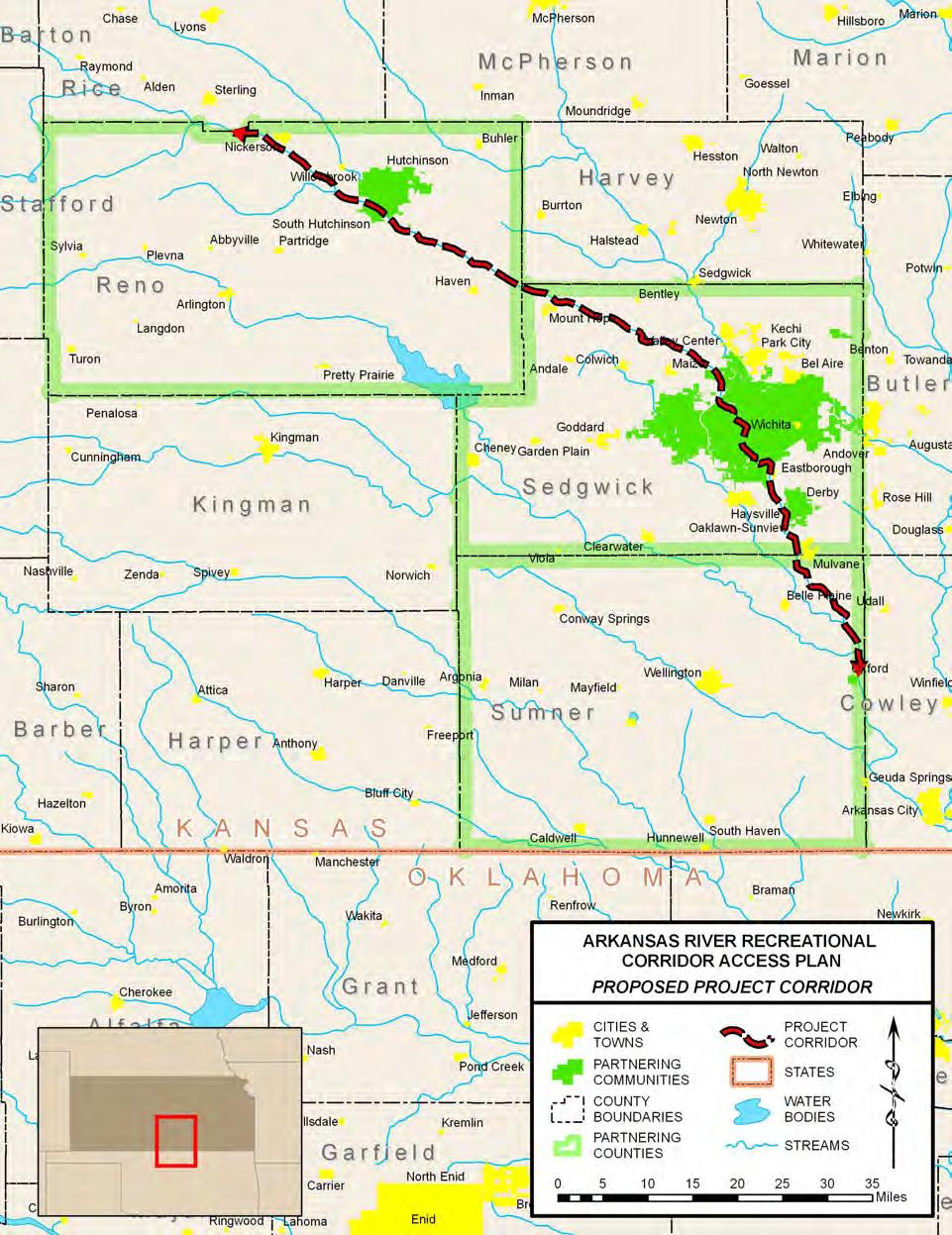
17 ACCESS POINT RECOMMENDATIONS Introduction In order to establish the Arkansas River as a premiere recreational amenity for the state and the region, it is necessary to provide safe access to the River in the appropriate locations. To this end, the project partners wished to identify approximately twenty access opportunities along the River. To ensure that recommended access points meet basic criteria for safety, recreational functionality, natural resource protection, hydrologic constraints, and public expectations, a multi-tiered site selection process was used. This site selection process incorporated input from the public and from recreational users, as well as Geographic Information System (GIS) analyses and field surveys. The outcome of this process is a regional system of recommended access points that will provide the recreational functionality desired by the project partners. 21
18 STUDY PROCESS This section describes the multi-tiered approach that was used to select the prioritized access points along the corridor. 22 Public Outreach During the Public Meetings (Section 1), the project team solicited comments from the public regarding their expectations for access point locations, as well as concerns regarding specific areas along the corridor where problems are currently being experienced due to misuse of the corridor. These comments were recorded by the project team and were summarized to provide an understanding of common themes regarding these aspects of the site selection process (Appendix A). These summaries were used to guide the site selection process, providing a way to filter access opportunities by making use of these firsthand accounts of the River. Additionally, during the Technical Workshop (Section 1), the project team met with experienced recreational users, biologists and others with technical backgrounds, to develop some basic guidelines on preferred access point spacing, required access types and amenities, and stream flow characteristics needed at different portions of the River. As with the Public Meetings, these notes were compiled and summarized (Appendix A), and used to inform decisions regarding the recommended access points contained within the plan. Site Suitability Analysis An interactive approach utilized GIS data and tools to identify potential access point locations (Figure 2.2). The first step in the process was to map existing access points along the corridor to serve as the anchor points for access point development. This information was obtained from steering committee members, and from Access Point Identification Forms (Appendix B) received from recreational users and landowners. Accessibility Figure 2.1. Site selection process overview In order to minimize implementation costs by reducing or eliminating the amount of land to be purchased or leased, and the number and mileage of roads to be built, accessibility to the River from publicly-owned land was the primary constraint used to filter potential access points. Several methods were used to identify locations with the potential for access on existing public lands. Parcel data was obtained from Reno, Sedgwick, and Sumner Counties. These data served several purposes within the analysis. First, parcel data represents land owned by private entities (including incorporated entities such as businesses, and nonprofit institutions), any areas not mapped in these parcel layers represent public land. Therefore, an inverse of the parcel data was created to provide a layer representing public lands held either as right-of-way or as the navigable waterway of the
19 Arkansas River (Figure 2.2). Parcel data is used for estimating acreages for tax purposes, and is therefore not a legal definition of property ownership. However, it provides the best representation of ownership available in a digital, GIS-based format, and is therefore the best approximation available for road rights-of-way and the Ordinary High Water Mark (OHWM) of the Arkansas River. Next, GIS was used to create a series of points at any location where roads or road rights-of-way intersected the approximated OHWM. These locations represented places where acquisition is not necessary to provide public access to the River. Next, GIS was used to query parcels based on ownership keywords and land use codes to identify city- or county-owned properties that are adjacent to the approximated OHWM. Parcels were again queried based on land use codes to identify parcels not publicly owned that may have represented other opportunities for creating access, such as parks, campgrounds, churches, and vacant industrial land. Places where public roads, road rights-ofway, or publicly owned parcels intersected the approximated OHWM were mapped as potential access locations. These locations were then filtered within the context of the stream stability, hydrology, and ecological sensitivity criteria, as well as by their proximity to existing access points, as described below. Stream Stability Stream stability was assessed for each potential access location identified by applying the accessibility constraints described above. To determine the relative level of stability Figure 2.2. The Erase command in ArcView GIS was used with county parcel data (1) to Figure 2.2. The Erase command in ArcView GIS was used with county parcel data (1) to generate a layer representing a combination of road rights-of-way and the navigable waterway of the Arkansas River (2). This layer was then manually split to create two separate layers; one representing road rights-of-way and another representing the navigable waterway of the Arkansas River. along reaches of the River, current hydrologic data was mapped against historical River locations inferred from parcel records. USGS records were also used to determine changes in the stream channel near each gaging station during the last ten years (Section 5). Stability assessments made by a hydrologist during field surveys were also referenced in filtering potential access point locations. Hydrology As described in Section 5 of this document, hydrologic data from the United States Geological Survey (USGS) gaging station records, in conjunction with general guidelines obtained from long-time recreational users of the River, were used to determine the suitability of the River for recreational floating on reaches surrounding the gaging stations. Mean annual flows and monthly average flows were graphed for each of the gaging stations with sufficient records along the corridor. An assessment was made regarding the regularity of flows capable of supporting canoeing and kayaking. 23
20 24 Ecological Sensitivity Each potential access point location was evaluated for potential impacts to sensitive wildlife species. These locations were overlain with data from the Natural Heritage Inventory (NHI) element occurrence records for rare plants, animals, and plant communities (Kansas Biological Survey 2007), rare species observations (Kansas Biological Survey 1997), and Designated Critical Habitat for Threatened and Endangered species (Kansas Department of Wildlife and Parks 1997). Any potential access point located close to any of the mapped sensitive natural resources was noted, and the corresponding access point description (Appendix B) contains additional guidelines for the site. Access Point Spacing and Distribution Another significant consideration in selecting opportunities for access point development was the overall layout and distribution of access points along the corridor. The project team collected feedback during the Public Meetings and Technical Workshop from area canoeists and kayakers about the appropriate spacing between access points to create rewarding recreational experiences. Additionally, it was necessary to consider the way in which different types of access points (Primary, Secondary, and Primitive Section 3) must be distributed to create a corridor that meets the recreational objectives of users with varying levels of experience and expectations. The process for selecting points based on distribution was iterative. Existing access points were mapped to serve as the anchor points for the corridor. With these anchor points in place, all potential access point locations were evaluated to determine which represented the best opportunity for enhancing the functionality provided by the existing points, given the criteria outlined above. Incorporating this highest priority potential access point into the system of existing sites, the process was then repeated to select the next potential access point to include, and so on. Field Survey A field survey was conducted to verify the initial results from the GIS-based site suitability analysis. In order to minimize costs and maximize the efficiency of the access point selection process, field surveys were conducted while the project team was in the Wichita area for a Steering Committee Meeting on January 16, 2007, for the Initial Public Meetings on February 12-13, 2007, and for the Technical Workshop held on March 26, This allowed an iterative, adaptive process in site selection, since new sites found during field surveys could be reviewed using GIS, and vice versa. Each location that appeared to provide a good access opportunity according to the GIS-based process was visited during the field surveys. Sites were photographed and an Access Point Identification Form (Appendix B) completed for each site, to record attributes present at the site. Items noted included the steepness of stream banks, land area available for amenity development, and potential hazards or other special considerations present. The project hydrologist assessed the apparent stability of the stream banks, and the project ecologist noted any natural resources of interest. Categorization and Prioritization Recommended access points identified through the above filtering process were categorized
21 based on the level of service (Primitive, Secondary, or Primary) deemed appropriate at each location (Section 3). The determination as to the appropriate level of service at each site was made primarily on the basis of two factors. First, the location of the site along the corridor in relation to cities and other access points was considered. Input was received in the Technical Workshop from KDWP personnel, city staff, and recreational users as to levels of service appropriate given these locational considerations. Primary sites those which may feature a more complete set of amenities, such as camping and picnic areas should be close enough to cities to make maintenance and enforcement relatively easy and convenient. However, primary sites should not necessarily be limited to cities, as this would be less desirable to recreational users wishing to experience nature, and could invite undesirable or unlawful usage. Second, the amount of available space limits the possible development of site amenities. Sites where only a very limited amount of space was available were recommended as primitive sites, which may feature no more than off-street parking and a safe path to the River. Based on parcel data and the field surveys, a determination was made regarding the level of service that could be provided at each site, including limitations of space for parking and additional amenities. Prioritization Recommended access points were then prioritized based on their importance in creating a functional recreational corridor. For potential access points, where no formal access currently exists, the priority rating indicates the importance in creating formal access. Existing access points were also given a priority rating; this rating indicates the importance of establishing additional amenities at an existing site to enhance its recreational functionality. Points were assigned a high priority if they were required immediately to address safety concerns, such as the dam obstructions in Wichita. High priority status was also given to those points that provide excellent opportunities for access development at a good trip distance (approximately five to ten miles) from existing points. A medium priority was given to potential sites that present a good opportunity to significantly improve access, but are less important to creating a functional corridor than the higher priority sites. Existing sites were also assigned a medium priority if they were currently functional and being used by recreational users accessing the River, but would benefit from additional amenities, such as enhanced signage or parking. Low priority sites were those where opportunities exist to provide additional access, but where site limitations (e.g. limited parking, steep river banks), proximity to higher priority sites, or other attributes made the site of lower importance to the initial implementation of the plan. Access Point Naming All existing and proposed access points were assigned a unique identifier, interpolated from the locations of known U.S. Army Corps of Engineers mileages at USGS gaging stations along the River. River mileages for the Arkansas River start at zero at its confluence with the Mississippi in southeast Arkansas, and go up in an upstream direction. These river mileages were created using historical map data, and may not accurately represent the distance that will be traveled between two points on the River. However, these mileages were used to assure consistency with potential future access point development upstream or downstream of the ARCAP project reach. 25
22 FINDINGS 26 Accessibility Approximately forty locations were found where public roads cross or otherwise reach the OHWM of the Arkansas River, most of which provide legal public access to the stream channel along road rights-of-way. However, many of these road crossings have site-specific limitations due to narrow rights-of-way, a lack of parking, unsafe paths down to the River, or steep banks, or they may occur at a distance from existing or higher priority sites that do not significantly increase the recreational functionality of the corridor. These forty locations where public roads intersect the OHWM were filtered down to five locations that provide the best opportunities for access point development, based on the other site selection criteria described below. Likewise, although approximately one hundred city or county owned parcels exist adjacent to the River, the majority of these public parcels sixtyseven and sixteen, respectively are within the City of Wichita or the City of Hutchinson, where access opportunities are numerous. In many cases, recreational access point development would not have been compatible with current or projected uses of the properties in question. Of the approximately one hundred public parcels that were evaluated for potential access point development, eight points were identified using the other site selection criteria described below. Access Point Spacing and Distribution During the Technical Workshop and Public Meetings, feedback was received from user groups regarding the appropriate spacing for access points. Some users felt that the desired five-mile intervals requested by the steering committee were shorter than what was required for most recreational users; some stated that eight to ten miles was a more appropriate stretch. However, all appeared to agree that it would be best to provide a mixture of trip lengths, to accommodate the time limitations, abilities and desires of a variety of users. Additionally, some experienced paddlers suggested that a five-mile spacing in the upper (northwestern) reaches of the River would be appropriate given the slower speeds at which one generally floats in those reaches. Stream Stability As the majority of the potential access points occur at existing bridges or within cities, stream stability was not a significant constraint on proposed locations for access point development. However, at each recommended access point location, the stability assessment made during the field surveys was used to help determine what types of access point would be appropriate, and, in many cases, which bank (left or right) provided the easiest and most consistently available access, regardless of river stage. Hydrology It was determined that in most years, the entire project reach would contain adequate flows for floating during a season extending from March through July. Therefore, hydrology did not impose any constraints on potential locations for access points. However, the lower (southern) reaches of the River do provide more consistent and more diverse opportunities for watercraft usage, and may therefore be more attractive as a recreational amenity to a larger number of potential users (Section 5).
23 Ecological Sensitivity The entire project reach is considered critical habitat for the Arkansas River Shiner and the Arkansas River Speckled Chub, both endangered fish species in the State of Kansas,. The reach upstream of Woodberry Road is considered critical habitat for the Arkansas Darter, a threatened species in the State of Kansas. It is unlikely that access point development will significantly impact these species; however, each proposed access point should be evaluated at the time of implementation by an aquatic biologist familiar with these species and their occurrence and requirements within the Arkansas River. With the exception of the fish species mentioned above, only one observation record for a sensitive species was found to overlap with a proposed access point location (see the text associated with the proposed access point at Mile 767, The Tubes, in Appendix B). Though the existing records indicated only one potential conflict with sensitive species, these records are not comprehensive; it is likely that other sensitive species or communities may occur in close proximity to proposed access points. In addition, the River and its surrounding corridor provide habitat for other threatened and endangered species, such as the eastern spotted skunk, least tern, bald eagle, and silver chub, as well as other rare species such as the glossy snake, alligator snapping turtle, American avocet, black-crowned night heron, little blue heron, and snowy egret. In order to protect the species mentioned above, as well as other wildlife, site-specific access point plans should be reviewed by biologists for potential impacts. Public Outreach Significant notes and features drawn by members of the public on the maps used during the public meetings were incorporated into the GIS dataset containing potential access point locations. These notes, as well as comments received by mail, , and phone were referenced to assist in further filtering potential access point locations. During the Public Meetings, and through comments received via mail, phone, and , it was apparent that landowners between Yoder Road and Woodberry Road were concerned about establishing access points along that reach, given problems they are currently experiencing. Throughout this same reach of the River, there were no good opportunities identified for access points using the selection criteria defined in Section 2.2.2, as very few road crossings or public lands exist there. The existing road crossings along this reach were not good candidates for access points due to limitations in safe parking, steep river banks, or other site-specific constraints. Therefore, access point development has not been recommended between those points on the River at this time. However, it is possible that other landowners along the corridor may show interest in selling an access easement or establishing access through their property in the future. 27

24 RECOMMENDATIONS Figure 2.3 ARCAP access point location map Identified Access Points Twenty-three existing or recommended access points were identified along the approximately 105-mile project reach of the Arkansas River (Table 2.2). Ten of these 23 locations were existing access points established and maintained by a public entity. The remaining 13 locations are recommended access points on publicly-owned properties along the corridor. Additionally, nearly 30 other opportunities for access point development were identified in places where roads provide access to the River, but where access point feasibility is uncertain due to questions regarding ownership, safety, or space limitations (Section 2.6). 28
25 River Mile Point Name Status 826 Nickerson Brush Dump Type (Level of Service) Priority Landowner Potential Primary High City of Nickerson 824 Nickerson Road Potential Primitive Low Reno County 816 4th Street Hutchinson Existing Primary High City of Hutchinson 811 Cary Park Existing Secondary Medium City of Hutchinson 806 Eales Roads Potential Primitive High Reno County st Street Potential Primary High City of Wichita th Street/ Clearwater Road Potential Primitive Low Sedgwick County rd Street Potential Primary High State of Kansas st Street Existing Secondary Low City of Wichita 767 Tubes Takeout Potential Primitive High City of Wichita 764 Sim Park Potential Secondary Low City of Wichita 763 Gander Mountain Existing Secondary Low City of Wichita Lincoln Street Above Dam Lincoln Street Below Dam Existing Primitive High City of Wichita Existing Primitive High City of Wichita 760 Watson Park Potential Secondary Low City of Wichita 760 Herman Hill Park Potential Secondary Low City of Wichita 758 Garvey Park Existing Secondary Low City of Wichita st Existing Primary High City of Wichita 750 West Washington Street Existing Primitive Low City of Derby 750 Derby City Yard Potential Secondary High City of Derby th-Mulvane Property Potential Primary High City of Mulvane 740 Rock Road & 130th Potential Primitive High Sumner County 724 Oxford Existing Secondary Low City of Oxford Table 2.1 Identified access points along the ARCAP project corridor 29
26 30 Access Point Distribution The twenty-three existing and recommended access points create an average spacing of approximately 4.8 miles between points; however, these access points are not evenly distributed along the corridor (Table 2.2). While access points in Wichita are spaced relatively closely together, two longer reaches the 24 mile reach from Yoder Road to 151st and a reach of approximately 17 miles between 130th and Oxford have no recommended access points due to a lack of public land and access on public roads. The variability in distances between access points will provide users with varying skill levels and recreational objectives with floatable reaches that meet their preferences for trip length.
27 Reach Starting Point Ending Point Length (Miles) 1 Mile 826 (K96) Mile 824 (Nickerson Road) 2 2 Mile 824 (Nickerson Road) Mile 816 (4th Street, Hutchinson) 8 3 Mile 816 (4th Street, Hutchinson) Mile 811 (Cary Park, Hutchinson) 5 4 Mile 811 (Cary Park, Hutchinson) Mile 806 (Eales Road) 5 5 Mile 806 (Eales Road) Mile 782 (151st Street) 24 6 Mile 782 (151st Street) Mile 780 (Maize) 2 7 Mile 780 (119th/Clearwater) Mile 772 (53rd Street) 8 8 Mile 772 (53rd Street) Mile 767 (The Tubes/21st Street) 5 9 Mile 767 (The Tubes/21st Street) Mile 764 (Sim Park) 3 10 Mile 764 (Sim Park, Wichita) Mile 763 (Gander Mountain) 2 11 Mile 763 (Gander Mountain) Mile 762 (Lincoln Street) Mile 762 (Lincoln Street) Mile 760 (Herman Hill Park) 2 13 Mile 760 (Herman Hill Park) Mile 760 (Watson Park) Mile 760 (Watson Park) Mile 758 (Garvey Park) 1 15 Mile 758 (Garvey Park) Mile 751 (71st Street) 7 16 Mile 751 (71st Street) Mile 750 (Derby City Yard) 2 17 Mile 750 (Derby City Yard*) Mile 743 (119th, Mulvane) 6 18 Mile 743 (119th, Mulvane) Mile 740 (Rock Road & 130th) 2 19 Mile 740 (Rock Road & 130th) Mile 724 (Cave Park, Oxford) 17 *Primitive access is currently available nearby within the right-of-way of West Washington Avenue in Derby at approximately the same river mileage. Table 2.2 Access point spacing along the ARCAP project corridor 31
28 IMPLEMENTATION 32 The following section defines action items required of members of the Coalition in order for the Plan to be successfully implemented. Action items are listed by the responsible entity for each item, and include specific tasks needed to achieve the objectives of the Plan. In some cases, numerous entities may be responsible for separate tasks to achieve a given objective. For objectives where this is the case, both entities have been identified with their respective action items. A brief statement to justify the action for each recommended access point is included. Some of the recommended access points do not have any actions associated with their location. City of Wichita 21st Street recreational transition Justification: Safe passage over dam obstruction Action: Design and construct a recreational transition that provides safe passage over the dam obstruction. Develop enhanced access upstream and downstream of the transition to accommodate increased numbers of users. Design and construct streamside observation and picnic areas for those watching family and friends floating the reaches and participating in events. Signage is needed for both warnings and information. Signs are needed upstream from each site as warnings of rapids and that portage is required to avoid them. Information signs should accompany the warning instructing boaters about where the take out point is and when they should make their way to the bank to avoid being pulled into the contraction. Information signs at the roadways directing users to parking, equipment staging areas, put in points, and observation areas are needed. Information signs about rules of behavior and safety requirements are needed throughout the area. Lincoln Street recreational transition Justification: Safe passage over dam obstruction Action: Design and construct a recreational transition that provides safe passage over the dam obstruction. Develop enhanced access upstream and downstream of the transition to accommodate increased numbers of users. Design and construct streamside observation and picnic areas for those watching family and friends floating the reaches and participating in events. Signage is needed for both warnings and information. Signs are needed upstream from each site as warnings of rapids and that portage is required to avoid them. Information signs should accompany the warning instructing boaters about where the take out point is and when they should make their way to the bank to avoid being pulled into the contraction. Information signs at the roadways directing users to parking, equipment staging areas, put in points, and observation areas are needed. Information signs about rules of behavior and safety requirements are needed throughout the area.
29 Mile 767, 21 st Street, Wichita Justification: Safe passage over dam obstruction Action: Install signage warning users of danger presented by dam. Install signage informing users of takeout points downstream from the put-in below the 21st Street dam. Develop a more functional takeout point on the right bank sufficiently upstream from the bridge. Mile 763, Gander Mountain Justification: Funding and promotional resource Action: Engage Gander Mountain as a potential partner in creating a whitewater park downtown. Install signage warning users of danger downstream presented by Lincoln Street dams. Mile 762, Lincoln Street Takeout and Launch Points Justification: Establish portage at dam obstruction Action: Install signage and amenities consistent with a primitive access point. Install signage directing users to parking at small lot near the intersection of South Palisade Street and West Bayley Street. Install warning signage at least 500 upstream of the dam warning users that they must use the takeout. Create a takeout point consisting of a stable point with low banks connected to the River corridor trail by a footpath. Engage Gander Mountain, and other potential partners, in cooperating to create a whitewater park at the Lincoln Street dam. Develop a more functional takeout point on the right bank sufficiently upstream from the bridge. Mile 758, Garvey Park Justification: Enhancement to existing site Action: Install signage and amenities consistent with a secondary access point. Mile 751, 71 st Street Justification: Take advantage of greenspace for native landscapes and added amenities. Action: Continue working with law enforcement to resolve issues with incompatible uses. Install signage from Hydraulic Street to the site to direct users to the site. Consider partnership with KDWP or other potential funding source for restoration of native prairie, woodland, and forest on the site. Establish amenities consistent with those defined for primary access points, to include camping, if desired. Correct erosion problems by using native landscaping to protect sensitive slopes and stream banks. Install signage directing users to access point location. 33
30 Mile 782, 151 st Street Justification: The terminus of a long reach without paddle access. Action: Work with Water Department to set aside all or part of this property for use as a primary access point. Create a plan for establishing primary access at this point, including a plan and schedule for maintenance and enforcement; regular and visible maintenance and enforcement will be critical for this site, given its relatively isolated location and potentially heavy usage. Install features consistent with those recommended for a primary access point, as desired and feasible. Mile 772, 53 rd Street Justification: The last rural or natural access point upstream of Wichita Action: Work with the Kansas Department of Wildlife and Parks to plan and implement primary access at this location. Mile 767, The Tubes Takeout along with Kansas Department of Wildlife and Parks Justification: A portage site upstream from the The Tubes a hazard for inexperienced boaters Action: Assess potential impacts of any actions to endangered least tern that might be using sandbars in this area for nesting on an annual basis. Install signage upstream from The Tubes warning users of potential dangers present downstream and instructing them to take out at the access point or portage over the levee. Create a primitive access point on the south side of the River, north of I-235, from 25th Street. Mile 767, The Tubes Takeout along with Kansas Department of Wildlife and Parks Justification: A portage site upstream from the The Tubes a hazard for inexperienced boaters Action: Assess potential impacts of any actions to endangered least tern that might be using sandbars in this area for nesting on an annual basis. Install signage upstream from The Tubes warning users of potential dangers present downstream and instructing them to take out at the access point or portage over the levee. Create a primitive access point on the south side of the River, north of I-235, from 25th Street. 34
31 Mile 764, Sim Park Justification: An essential portage site around the Lincoln Street dam. Also a launch site for passage over the dam. Action: Establish Lincoln Street Upstream Takeout first. Create marked parking area and signage indicating formal access to the River via a footpath down to the River, and install other signage consistent with that recommended for primitive sites, but with additional language describing the hazard presented downstream by the Lincoln Street dam. Mile 760, Herman Hill Park Justification: Alternate take out downstream from transition at Lincoln St. dam Action: Determine whether this location or the location at Mile 760, Watson Park, is preferred as a primary, secondary, or primitive access point; either could provide excellent access point, but one likely makes more sense for the City, depending on land use plans, conflicts or collaboration on special events, and other special considerations. If this site is chosen over (or in addition to) the one at Watson Park, install signage directing users where to park, for unloading, or for short-term or overnight parking. Create an easier path to River as current banks are steep and make launching difficult. Mile 760, Watson Park Justification: Alternative take out downstream from transition at Lincoln St. dam. Action: Determine whether this location or the location at Mile 760, Herman Hill Park, is preferred as a primary, secondary, or primitive access point; either could provide excellent access point, but one or the other likely makes more sense for the City, depending on future land use plans, conflicts or collaboration on special events, and other special considerations beyond those reviewed within this project. If this site is chosen over (or in addition to) the one at Herman Hill Park, install signage directing users where to park, for unloading, or for short-term or overnight parking. Consider installing a ramp in this location, or, at a minimum, a parking loop closer to the River, to enhance accessibility. 35
32 City of Hutchinson Mile 816 4th Street Justification: Launch site through Hutchinson city park Action: Establish signage along 4th Street, at K-96 exit, and from the City of Hutchinson to direct users to site. Install standard signage regarding safety, regulations, usage, etc. Explore the possibility of creating additional amenities such as camping, picnic areas, hiking/biking trails, and wildlife viewing areas. Needs steps or some other safer path down to River. Construction of a path and/or steps would make an ideal Eagle Scout project, and could be done with volunteer labor and donated materials. City of Oxford Mile 724, Cave Park Justification: A prominent city amenity. Action: Install signage informing users of regulations & restrictions, as well as safety considerations for the River. Consider the potential for integrating the Old Mill and floodplain areas as a regional park and destination point, connected to the existing access point by hiking or biking trails; look to a park such as Indian Cave State Park in southeastern Nebraska as an example of a beautiful riverside park that successfully integrates areas of historical interest, expansive natural areas, hiking and biking trails, and other amenities that draw thousands of visitors annually and provide a boost to the local economy. 36 Mile 811, Cary Park Justification: Takeout downstream from the city park. Action: Create signage consistent with that listed in Section 2 of this document for primary and secondary sites. Install signage informing users of appropriate places for overnight parking, if desired, and install signage directing users to parking and access from park entrance. City of Mulvane Mile 743, 119th, Mulvane Property Justification: An opportunity for the city of Mulvane and takeout downstream from Derby Action: Work with the Coalition to create a site plan that identifies amenities consistent with the level of services desired in this portion of the corridor, and to identify potential funding sources that can facilitate implementation. Restore selected portions of the site to natural vegetation (including prairie and forests) and create trails and other nature-based amenities to increase the potential draw to users such as hikers and birdwatchers.
33 City of Derby Mile 750, Washington Avenue Justification: Alternate access for Derby Action: Work with developer across the River to ensure that City and privately developed access points support, rather than compete with each other. Create signage from West Market Street to guide users to site, and establish signage as recommended for primitive access points. Install signage indicating the availability of access at this point, and stripe areas to create controlled parking. Monitor erosion at the site to be sure minor erosion noted during the field survey does not worsen. Mile 750, Derby City Yard Justification: Access Opportunity for Derby Action: Continue discussions with landowner across the River to explore potential partnerships and cost-sharing on development of a boat ramp and other facilities. As an interim measure to improve access, install signage directing users from Market Street to the existing access point at the end of West Washington Avenue. City of Nickerson Mile 826, Nickerson Brush Dump Justification: Launch point at upstream end of corridor Action: Begin by creating a plan that spells out how this site may work in conjunction with the site at Mile 824 on Nickerson Road or other sites of interest. Create a plan to provide formalized primitive access at this location, and expand site with more amenities as interest grows. Create parking areas in current brush dump site for recreational users. Install path or narrow road along K-96 to create linkage between City property and River. Install signage informing users of access point regulations. Install amenities consistent with primary or secondary access points. Mile 824, Nickerson Road Justification: Alternate launch point at upstream end of corridor Action: Begin by creating a plan that spells out how this site may work in conjunction with the site at Mile 826 at the Nickerson Brush Dump or other sites of interest. Install signage directing users where to park along 69th Avenue to create a functional primitive access point. Create a marked trail down to the River from the road to prevent users from crossing private lands. Explore possibility of acquiring or leasing isolated properties, as described in section
34 Reno County Mile 806, Eales Road Justification: Launch point for long natural reach downstream from Hutchinson. Action: Create a plan for establishing access at this point, including a plan and schedule for maintenance and enforcement. Create a parking lot in the right-of-way of Eales Road and Yoder Road, north of the River and east of Yoder Road. Provide signage consistent with that recommended for primitive access points. Sedgwick County Mile 780, 119 th Street/Clearwater Road Justification: Action: Coordinate with the City of Wichita to discuss development of this access point versus the point at Mile 782; it may not be necessary to develop both This location may provide a good primitive access point while the site at Mile 782 is being planned or under construction. Install signage informing users of appropriate places for parking and permitted use of the area within the levee. Sumner County Mile 740, Rock Road & 130 th Street Justification: Launch point for long natural reach downstream to Oxford Action: Review county right-of-way and private deeds, as necessary, to determine the boundary and size of the area available for development. Include graveling and other maintenance of the location as a part of the maintenance of Rock Road and 130th Street. Install signage so that recreational users understand where they are to park and to ensure that they are not blocking access to adjacent private parcels by the landowners. Enlist the support of a local group, such as a Boy Scout troop from Mulvane, Belle Plaine, or another nearby town, to construct a footpath down to the River. Consider creating a poured concrete landing at the foot of the existing abutment to provide a stable launching point for boats, 38
35 Kansas Department of Wildlife and Parks Mile 772, 53 rd Street Justification: The last rural or natural access point upstream of Wichita Action: Work with City of Wichita to develop a plan for creating a primary access point in this location. Create a primitive access point with signage and other basic amenities consistent with those recommended for primitive sites, including parking and signage above the levee on public property, to provide carry-in access at this point, and develop the location as a primary access point as feasible. Install signage informing users of appropriate places for parking and permitted use of the area within the levee. Mile 767, The Tubes Takeout, Action Items for the City of Wichita and the Kansas Department of Wildlife and Parks Justification: Action: Assess potential impacts of any actions to endangered least tern that might be using sandbars in this area for nesting on an annual basis. Install signage upstream from The Tubes warning users of potential dangers present downstream and instructing them to take out at the access point or portage over the levee. Create a primitive access point on the south side of the River, north of I-235, from 25th Street. At bridges and access points along the corridor Justification: Action: Prepare and install signs at bridges and access posting information describing the ordinary high water mark as the boundary between private and public property. Along the corridor Justification: Action: Prepare a definition of destructive uses and disruptive behavior that will be considered unlawful. This definition should not be written as a list of specific actions. 39
36 OTHER ACCESS POINT OPPORTUNITIES In addition to the twenty-three access point opportunities identified, other opportunities may exist for creating public access to the River. Fourteen other locations were identified as potential opportunities for access point development. These locations were either places where public road rights-of-way crossed the River, or places where a public road could be extended a relatively short distance to provide access to the River. Six of these 14 opportunities exist within public road rights-of-way (Table 2.4). Primitive access could be created at most of these locations simply by providing a safe place to park off of busy roads, and a safe path down to the River, with appropriate signage. Limitations at these sites included narrow rights-of-way, high traffic roads, high stream banks, or other attributes that prevented their listing as potential access points. The remaining eight locations specified (Table 2.5) are opportunities where a public road could be extended a relatively short distance through private lands, if the owner is willing to sell or donate an easement for access. Due to uncertainties involving ownership of land surrounding roads mapped as public, as well as uncertainty regarding the level of interest from landowners in selling or leasing access easements, it was impossible to determine which of these locations presented the best opportunities. These uncertainties must be resolved by the Coalition as implementation of the Plan moves forward. Justification for additional access points are for more flexibility in planning a boat trip, added access for emergencies, and to encourage opportunities for private economic benefits along the River corridor. 40
37 River Mile Point Name Priority Notes 800 Haven Rd. High Approximate 150 R.O.W. surrounding to bridge; appears to be a 100 x 1000 parking area in R.O.W. at the intersection of Haven & Red Rock Roads; could create parking here, provide footpath or narrow road down to River from existing parking area 796 Worthington Rd. Low Approximate 150 R.O.W. surrounding to bridge; ATV traffic has created path from private drive on east side of Worthington Road, north of River; could establish parking within R.O.W.; adjacent landowner has described many problems with trespassing and theft, so enforcement would be critical 793 Mount Hope High 1.5 miles north of Mt. Hope on 279 th Street; Approximate midpoint of long (24-mile) reach between recommended access points at Eales Road and 151 st Street makes this an important site 782 Big Slough Cr. Low 77 th Street R.O.W. provides apparent public access to Big Slough Creek, which appears to be entirely within the public R.O.W. associated with K-96/77 th Street; Creek flows into the Arkansas River approximately 0.5 miles from potential access point opportunity; access limited by big creek slough floatability 776 Ridge Road Low Large land area within levee appears to be public; parking could be created within the levee to provide primitive access; this site only important if sites at miles 780 and 772 are not feasible, given the proximity of these higher priority sites upstream and downstream th Avenue High Approximate 80 R.O.W. might provide feasible access point if adequate space is available for pull-off parking, or if adjacent landowners willing to sell or lease an easement; location near mid-point of 16 mile reach with limited opportunities make this site a priority to explore Table 2.3 Other Access Point Opportunities in Public Rights-of-Way 41
38 River Mile Point Name Priority Notes 778 Church Camps Low Two church camps (owned by the First Presbyterian Church of Wichita and the Heart of Kansas Southern Baptist Association) lie adjacent to the River at this location; potential for partnership in developing a boat ramp that would serve the public and the camps with cost-share from City and church group; potential sites at miles 780 and 772 likely provide adequate access without this site, unless those accesses are not attainable 750 Lusk Property High Private landowner currently plans to develop his riverside land as an access point with a boat ramp and campground; City of Derby is talking with this landowner th Avenue Low 120 th Avenue could be extended approximately 0.25 to 0.5 miles to River from either bank to provide access at this location, if one of the adjacent landowners is willing to sell or lease an easement th Avenue Medium Access would require extending 100 th Avenue approximately 500 through private lands, if an adjacent landowner is willing to sell or lease an easement th Avenue Medium Access would require extending road approximately 0.25 miles from either side to River, if adjacent landowner is willing to sell or lease an easement; Location near mid-point of 16 mile reach with limited opportunities make this site a priority to explore, but the opportunity at mile 733 is likely better th Avenue Low Appears to be no public R.O.W. associated with this road; extends to within 50 of River, so may provide an opportunity, if landowner is willing to sell or lease an easement; site is a low priority because it is very close to the existing site at Oxford th Avenue Low 30 th Avenue does not appear to have public R.O.W. along this stretch of the road; the road comes within 300 of the River; could create access along road if landowner is willing to sell or lease an easement; owner of portion appears to be same owner as Oxford Mill; site is a low priority because it is very close to the existing site at Oxford nd Rd. Low 122 nd, a Cowley County road, appears to come within 0.25 miles of the River, across the River from the opportunity on 30 th Avenue; could create access along road if landowner is willing to sell or lease an easement; site is a low priority because it is very close to the existing site at Oxford Table 2.4 Other Access Point Opportunities on Private Lands 42
39 ACCESS POINTS & AMENITIES Introduction Recreational access points to the Arkansas River were discussed at the Technical Workshop in Wichita March 27, Recreational boating and kayaking user groups along with sponsoring agencies discussed the level of service and types of access points needed along the River. The workshop resulted in recommendations that the access points be grouped into three types: Primary, Secondary, and Primitive. The types of amenities will be determined by access point location, expected use, accessibility and public desirability. Primary points, which will generally be located in urban areas, will have the most amenities and accessibility. Secondary points will provide some of the same amenities as the Primary points. Primitive points will generally be located in rural areas using road or highway right-of way and provide minimal services, focusing on providing a safe area to pull off the road and a path to the river. It is also important to determine the appropriate facilities, maintenance and enforcement for each access point prior to implementing construction of the access. 45
40 ACCESS POINT DESIGN When developing access points along the Arkansas River it is important to understand that it is a valuable recreational and ecological resource for the State of Kansas. Therefore, careful consideration should be given to maintaining and restoring the ecological value of all access points. The use of native plantings at these points is important to maintenance of each site and also to help stabilize the banks of the River. Also, the use of Best Management Practices (BMP s) for stormwater management is encouraged to help protect the water quality of the River. Signage placed at each access point should clearly indicate the boundaries of the public access points, the location where you are based upon the river mileage, river safety and hazards. Signage should also identify the guidelines of leave no trace such as; Plan Ahead and Prepare, Travel and Camp on Durable Surfaces, Dispose of Waste Properly, Leave What You Find, Minimize Campfire Impacts, Respect Wildlife, and Be Considerate of Other Visitors. In addition, the following recommendations are some general guidelines for developing the appropriate access point amenities. These recommendations are intended to be used for planning purposes only and should be modified to fit the specific conditions of the potential site. 46


41 Primary Access Points Primary access points are expected to have a higher use than any other access point type. Therefore, these points will need to be in areas that can accommodate large groups, ideally placing them in urban areas like the City of Wichita. Associating these access points with existing or future parks will help ensure the access ability to accommodate large groups and events. These accesses will be the most developed, including ADA accessible ramps and facilities. The amenities that should be included at each primary access point are: Boat Ramp Access Ramp Boat Trailer and User Parking Restroom Facilities and showers Interpretive Sign Take Out What You Bring River Miles Wildlife Information Boards Brochures Camping Areas where warranted or selected Lighting Fencing/Bollard System Water/Electric Trash Receptacles? Will need to be emptied if provided Figure 3.1 Primary Access Point 47

42 Secondary Access Points Secondary access points will experience high volumes of use but not likely by groups of people. Amenities within this access type should be provided at a level between those listed for primary points and those for primitive points. Amenities will need to provide ADA accessibility. The following amenities should be part of all secondary access points: Accessible Path to River Up to 10 Parking Spaces Boat Trailer Parking Bus Parking Concept Interpretive Signs Post No Trailer Access River Mileage Restrooms Figure 3.2 Secondary Access Point 48

43 Primitive Access Points Primitive access points will generally be limited to rural locations where people simply need reasonable and safe access to the river. Highway and road rights-of-way provide such opportunities. These access points will also make it possible for emergency and enforcement staff and vehicles to access the river. Amenities at these points will be limited: Path to River Up to 5 Parking Spaces or Pullover Area Signs River Mileage Figure 3.3 Primitive Access Point 49
44 MAINTENANCE AND ENFORCEMENT To ensure success, maintenance and enforcement of each access point must be addressed as a part of the site specific design and implementation. The sponsoring agency should identify the appropriate methods and funding for maintaining the elements of site-specific design as a part of the design process. Signage should be placed at each site so that it clearly indicates the responsible agency and their contact information, which will help user groups identify and report any ongoing issues at the access point. Furthermore, law enforcement agencies responsible for ongoing enforcement should be involved in the initial design. They can help eliminate design flaws through their understanding of Crime Prevention Through Environmental Design Principles, CPTED. They should also receive a map indicating the name, river mileage and location for ongoing enforcement operations. Implementation Public and private partnerships are integral to maximizing resources and funding for implementation of the access points. As the plan continues to move forward over time and the need and/or desire for additional access points becomes apparent, opportunities for access points may be limited to locations on private property. An option available in place of land acquisition is acquiring an easement from the landowner. This would provide the tools necessary to make access possible without incurring the higher cost of land acquisition. If an easement is desirable, attorneys should be consulted to facilitate the agreement. The Trust for Public Land and the Kansas Land Trust can also provide information and assistance with developing easements. Statewide grants through Kansas Department of Parks and Wildlife, Kansas Department of Health and Environment, or other state agencies should be researched as potential sources of funding for implementation of this plan. Local capital improvement programs may also be a source of funding as most of the locations within this plan are on public property and there may be opportunities to complete access points with other public improvement projects. 50
45 DAM OBSTRUCTIONS Introduction Dam obstructions at the 21 st Street bridge crossing and at the Lincoln Street Bridge crossing (Figure 4.1) prevent passage of boats and rafts. The elevation of the streambed has a vertical drop of several feet at each of these locations. There is no signage warning of the structures or instructions for take out upstream of them. A primary objective of the master plan is the conceptual design of a recreational transition through these obstructions. The transition would allow safe passage of boats and rafts through the bridges at these locations. The ecological continuity of the aquatic system was also to be considered. 53


46 STUDY PROCESS A description of potential sites was obtained by field site visits. Photographs were taken and measurements of key structural dimensions were obtained with a steel tape. Flows that were expected at the two sites were taken from USGS gaging station records. A recommended conceptual design that applies to each location was completed including flow and grade controls that result in a recreational transition of several moderate drops and pools. A technical workshop was conducted to discuss ideas and refinement of concepts. 54 General Characteristics Obstructions at these sites are constructed streambed grade control structures. They are broad crested weirs that span the width of the stream between the piers of the bridges. The weir at Lincoln Street is adjustable and can be raised and lowered pneumatically to impound water at greater depths periodically and create a temporary lake for various activities downtown. At normal flows the depths upstream from the weirs are a few feet and depths over the weirs are a foot or less. General geometry of the bridge openings and weirs are needed for a reasonable conceptual design. As-built plans of the bridges were not readily available and not essential to a conceptual design. Dimensions of the structures were taken from field measurements made with a steel tape relative to the bridge banister and the water surface at the time. The 21 st Street bridge and weir has 6 openings between piers that are each about Figure 4.1. Dam Obstructions Location Map Figure 4.2. Opening at the 21 st Street Bridge
.")


47 42 feet wide for a total opening width of about 250 feet. The drop in elevation downstream from the weir is in two stages. The first stage near the upstream side of the bridge drops about 5.5 feet and the second stage near the downstream side of the bridge drops about 2 feet for a total drop of 7.5 feet into the channel. The width of the bridge and roadway is about 80 feet (Appendix C). Figure 4.3. The 21 st Street Bridge The Lincoln Street bridge and weir has 5 openings between piers that are each about 85 feet wide for a total opening width of about 425 feet. The drop in elevation downstream from the weir is in two stages. The first stage drops about 6.5 feet and the second stage drops about 1.5 feet for a total drop of about 8 feet into the channel. Discussion of General Dimensions During the Technical Workshop specific design suggestions were obtained from experienced kayakers and canoeists. The consensus of the participants was that the chute containing the floatable transition must be a minimum of 17 to 20 feet wide. Elevation drops for each rapid in the transition is 1.5 to 2 feet in other established facilities. Narrower chutes create floatable depths for smaller flow rates which allow boating for a greater portion of the year when flows are minimal. Other existing facilities with similar total drops of 6 to 8 feet have a length of about 300 to 400 feet. This would result in 3 to 4 rapids of feet every 100 feet length of channel. Conceptual Design of a Recreational Transition A floatable transition over the weir and the drop in elevation of about 7 feet at each location requires structural fill behind the drop structure to establish a gradual transition in grade downstream of the weirs. It is not necessary to provide this transition for the entire width of the channel, only for a width sufficient to provide safe floatable passage for a novice boat user. It is also necessary to concentrate the flow to a narrow channel so depths at low flows will be adequate to float a boat. Flow rates at these locations are defined by the discharge records from USGS gages on the Arkansas River and the Little Arkansas River. The range of discharges that commonly Figure 4.4. Downstream from the Lincoln Bridge Figure 4.5. Opening at the Lincoln Street Bridge 55
48 occur will determine the general size the transition should be to create a reliable, floatable depth. Charts showing the Analysis of Flow records are included in Appendix C. Flow characteristics of the Arkansas River at the gage in Wichita are shown in the chart. The analysis was done for the most recent decade The first 5 year period is part of one of the wettest periods and the most recent 5 years is a period when flows were the lowest on record. Because the record captures a broad range of flow conditions, the analysis should provide representative flow expectations at the dam sites. A reliable, floatable depth over the weir would be about 1 foot. To achieve a floatable depth requires that flows that are currently evenly distributed over the entire width of the channel must be confined to a narrower channel to increase the depth of flow. A notch in the existing weir near one side of the channel would concentrate the flow in the notch at a greater depth. The narrower notch requires less flow to maintain a 1 foot depth. At larger flows the notch can be wider to keep the flows confined yet maintain a relatively shallow depth over the weir. A multi-width weir notch was evaluated to determine the general size requirements to pass expected discharges at floatable depths. The minimum size of the notch would be 20 feet to be consistent with the boating requirements defined at the Technical Workshop. The width of the span between piers at the 21 st Street Bridge is about 40 feet. It was found that a 25 foot notch in combination with a 40 foot notch would pass Figure 4.6 Drawing Figure of 4.6. Weir Drawing notches of Weir Notches the range of flows that would be expected most of the time. Geometries that would be consistent with these concepts are shown in Figure 4.6. A constructed transition chute downstream from the dam obstruction should be a series of short rapids and pools. The rapids would be created by a drop of 1.5 to 2 feet where the chute is narrowed to about 20 feet wide. Pools could be up to 40 feet wide with some obstacles within them. Width constrictions are created by anchoring large rocks or other obstacles to the bottom of the channel. The photograph in Figure 4.7 of a constructed chute shows a series of constrictions and pools to create rapids. 56
49 Benefits and Opportunities Information was obtained from other cities that have constructed whitewater recreation areas. General information about the physical characteristics from about 20 sites around the country was used to confirm the general dimensions of the transitions that might be constructed in Wichita. The average slope of those listed is about 1.1 %. Given a drop similar to Wichita of about 5 to 6 feet and the average slope of 1.1%; these sites would be about 450 feet in length. A site in Williamson, Michigan which has a drop of 6 feet and a length of 300 feet is similar to that contemplated for Wichita. It is constructed downstream from a dam and cost about $770,000 to build. There is no direct revenue from the facility as it is free to use as part of a City park. The premise was that the amenity would bring visitors to town. It has met that expectation to some extent but water quality (bacteria) was a problem. Another site in South Bend, Indiana has a drop of about 12 feet and is 1900 feet in length. The channel is 25 feet wide which is similar to that contemplated in Wichita. The site is totally constructed through downtown South Bend at a cost of $5 million. The rafting venue attracts from 450 to 700 boaters per day during good weather in the summer. A $4 user fee is charged to cover costs of operation and safety. The venue generates about 60% of the cost of operation. However, the restored downtown now generates $58 million in redevelopment revenue as a regional destination. Paddler Magazine has noted that whitewater venues are being constructed in many places. Some sense of the range in resources required relative to the recreational services was given in the article. The very short summer season for the Figure 4.7 Constructed chute and anchored obstacles site in Vail, Colorado generates $1 million each year which cost about $130,000 to construct. The highlight of the summary is the Ocoee River in Tennessee which is designed and constructed to Olympic specifications for $7.7 million. The approximately 1 mile reach would be a memorable experience that probably indicates the limits of expense and the ultimate in quality whitewater recreation. The site in Reno, Nevada is an indication of the return on investment that can occur in some circumstances. The whitewater reach was constructed with about $1.5 million and costs have been recovered from indirect revenues. For example, world class paddlers convened for the grand opening during which 30,000 people visited over 3 days and 10,000 rafts were rented. 57
50 Park Location Boulder, CO Denver, CO Durango, CO Golden, CO Salida, CO Steamboat Springs, CO Name of Park Boulder Creek Whitewater Park Confluence Park Durango Whitewater Park Clear Creek Whitewater Park Arkansas River Whitewater Park Dr. Rich Weiss Park Vail, CO Vail Whitewater Park South Bend, IN East Race Whitewater Course Dickerson, MD Dickerson Whitewater Course Williamston, MI Williamston Whitewater Park Rochester, NY Lock 32 Whitewater Park Ocoee River, TN Ocoee Whitewater Course Ogden, UT Ogden Kayak Park Wausau, WI Wausau Whitewater Park Green River, WY Green River Whitewater Park River Length Total Drop Cherry Creek and South Platte R. Animas River Clear Creek Arkansas River Yampa River (5 miles long) Gore Creek St. Joseph River Red Cedar River Slope Difficulty Season Contact Person II - III year round II - III year round II year round II April - June jkahn@ confluencekayaks.com jbrennan@frontier.net mike@arkrivertrust. org backdoor@cmn.net II - III May - July ian@visitvailvalley.com II - III June - Aug. 900 IV year round jwn@ripco.com bce@ccadc.org noonan@voyager.net Erie Canal II+ May 1 - Oct. 31 Ocoee River (1 mile long) Weber River Wisconsin River Green River blake6@frontiernet.net 5280 tvainfo@tva.gov II - III year round III - IV April - Oct. Redtallm@aol.com wkcc@dwave.net 600 jhartfor@wyoming. com Table 4.1 USA Whitewater Park Locations 58


51 Results and Findings A conceptual design of a recreational transition for the two dam locations was developed. Design components were developed from flow analysis, information obtained about existing sites elsewhere, and Technical Workshop discussions. Schematic Layout of Recreational Transition The transition is a constructed chute about 400 feet long. It is no more than 20 feet wide through a constructed riffle and no more than 40 feet wide in the pools. There are 4 to 5 pools and riffles through the reach with a drop of 1 to 1.5 feet at each riffle. It is expected that the chute would be constructed along one side of the channel to take advantage of the bank to serve as one side of the chute. The other side would be a constructed wall faced with stacked limestone to retain the appearance of a natural rock feature. The existing channel outside the wall would remain as a floodway bypass for river discharges that exceed the capacity of the chute. Expected Benefits and Opportunities Information from existing white water recreational amenities in other communities indicates significant benefits and economic opportunities. There is significant variability in costs depending on the level of recreational experience and extent of constructed flow and slope controls required. Mountain streams with natural rapids have costs similar to the Vail, Colorado example. It is not likely a recreational transition could be constructed in Wichita for similar low costs. In contrast, the ultimate recreation experience offered by the Figure 4.8 Conceptual Drawing and Photo of constructed chute Ocoee, Tennessee example that cost $7.7 million would require a substantial commitment by the city of Wichita to market this amenity as a major sporting destination. It may be a more appropriate expectation to have a recreational experience and facilities similar to those in Michigan or Indiana. Each of these constructed chutes are on mid-continent streams that do not have natural whitewater characteristics. They are located in regions where whitewater recreation is not commonplace. Associated Features The current dam obstructions are an impediment to all boaters. There is no current safe river passage for boaters of any skill level and portage is required. Currently there is a hard surface trail under the bridge at each location so put in and take out are possible. No warning or instructional signs exist at either location. Figure 4.9 Constucted chute Figure Kayaker in whitewater 59
52 60 Signs with instructions on safe approach and take out upstream from the Lincoln Street obstruction should be added for safe use of the reach upstream from it. The obstruction at 21 st Street is close to the structure where water passes through a multiple opening culvert through the levee requiring portage at this point. There would be no reason for most boaters to use this reach if there is no transition constructed at 21 st Street. There are skilled kayak users that do use the hydraulic wave that forms at the exit of the culvert when flow conditions are favorable. Existing put-in and takeout points are adequate for their current purposes. If a recreational transition is constructed the need for a portage for those not willing to float the rapids remains. Those that are using the whitewater reaches will need a safe and stable access for put-in and take-out. It is likely the rate of use for these points will increase substantially, particularly at times when the conditions are ideal and during special events. Other communities with these resources indicate these reaches will be used by boaters running the rapids repeatedly. Therefore these access points need to be large enough to accommodate large groups using the put in and take out over and over during an afternoon. Figure Photo of family paddling The 21 st Street location has an existing city park that has existing parking for about 20 vehicles and space for group buses. The Lincoln Street location has limited parking along the street. It would require additional parking if white water reaches were constructed. A whitewater reach not only attracts boaters but also observers that will want to be streamside to watch family and friends that are running the rapids. If kayak events are scheduled there will be event observers, fans, and supporters that will want streamside observation points. Linear park areas for folding chairs and picnics along the whitewater reach should be constructed for those enjoying the white water activities. Signage is needed for both areas. Signs are needed upstream from each site as warnings of rapids and that portage is required to avoid them. Information signs should accompany the warning instructing boaters about where the take out point is and when they should make their way to the bank to avoid being pulled into the contraction. Information signs at the roadways directing users to parking, equipment staging areas, put in points, and observation areas are needed. Information signs about rules of behavior and safety requirements are needed throughout the area. The Tubes (Floodway Inlet Structure to Downtown) The location known as The Tubes is a multiple opening concrete structure through the levee that controls River flows that enter the channel through downtown. The upstream inlet is at the entrance to the bypass floodway upstream from I-235. The outlet from the structure is upstream from 21 st Street. At moderate flows the outlet provides a hydraulic wave that is a recreational attraction for seasoned whitewater kayakers. At low flows the water is too shallow for the hydraulic wave to develop. Some modifications to the inlet geometry would direct flows to one opening only during


53 low flows. This modification would maintain a hydraulic wave at the one outlet increasing the times it is accessible for recreation. Some kayak users participating in the Technical Workshop have provided specific ideas for modifications to this structure. At high flows the hydraulic conditions are not amenable to recreation. The site is unsafe for those not trained and experienced in whitewater kayaks. Therefore it is essential to have an access point near the upstream side of the inlet to this structure for take-out and portage. Flows on the upstream side of the concrete structure are the entire discharge from the Arkansas River to this point. Prior to the construction of this structure, large flood discharges went through downtown Wichita causing flood damage. The Wichita and Valley Center Flood Protection project was constructed by the Corps of Engineers to control extreme flood discharges and prevent flooding of rural and urban lands in and adjacent to Valley Center and Wichita. A system of levees and floodways rerouting tributaries to the Arkansas River were constructed. The floodway created by the levees contain flood discharges of the Little Arkansas River, Arkansas River and several other tributaries near Valley Center and Wichita. Part of this system of flood controls is the concrete structure now called the Tubes designed to control the amount of flood water that flows into downtown Wichita. The flows exceeding the capacity of the Tubes enter the floodway around the City and reenter the Arkansas River upstream from Derby. At times the flood discharges coming from upstream are extremely hazardous and would not be safe for any instream recreation but would not exceed the River banks through downtown. Figure The Tubes 61
54 FLOATABLE CHARACTERISTICS Introduction Recreational use of the River for canoes, kayaks, and rafts requires a minimum depth of water for an enjoyable trip. Seasoned paddlers have skills that will allow them to use the River at depths less than those required for novice users. The Arkansas River upstream from Wichita has marginal flows for boats during some seasons of the year. It is important for planning to confirm the extent of the opportunities for floating the River. 63

55 STUDY PROCESS Hydrologic data from gaging station records were used to define flow characteristics. Field measurements of channel dimensions at given discharges were used to define typical depths at a range of flows. Figure 5.1 Annual mean discharge Figure 5.2 Daily Mean Flow Records from February 1997 to February 2007 Hydrology Gaging station records for the Arkansas River near Hutchinson, at Wichita and at Derby are available from the USGS. Annual mean discharges for the period of record for the gage at Hutchinson are shown on the graph.(figure 4.1). A running five year mean is also shown on the graph map to provide a more clear sense of the trends in climatic conditions as reflected in the streamflows. It was noted that the decade from 1995 to 2006 includes both a wet period and a dry period. The years from 1995 to 2000 include relatively high flows indicating a wet period. In contrast, the years 2001 to 2006 include low flows indicating a dry period. In fact 2006 has the lowest mean annual discharge of the period of record. This decade was chosen for further analysis as it representative of the range of flow and depth conditions for both a wet period and a dry period. Discharges that commonly occur will determine the times during the year that the flow is sufficient to float a boat. The chart of monthly flow at Hutchinson shows that during most months, the discharge is at least 100 cubic feet per second 75 percent of the time. More than half the time in spring and early summer the flows are at least 400 cubic feet per second, and at least 200 cubic feet per second the rest of the year. The discharge is more than 600 cubic feet per second 25 percent of the time in spring and summer. Flows at the Hutchinson gage reflect the discharge characteristics of the reach of the 64


56 River from Hutchinson to Wichita. There are no known or significant diversions out of the River so flows accumulate in the river as the contributing drainage area increases downstream. If flows are sufficient to float a boat in this reach the additional flows downstream will also likely be sufficient. Typical Depths The relationship between depth and discharge requires data that is not part of the gaging station information regularly provided by the USGS. Streamflow measurements are made by the USGS several times per year at each gaging station to maintain the rating at the station that relates stage Elevation drops for each rapid in the transition is 1.5 to 2 feet in other and discharge. Measurement records for the Hutchinson gage for a range of discharges were obtained from the USGS. A measurement requires that water depths be measured at numerous locations across the channel. The data can be plotted to show the depth of flow and channel shape at the time the measurement was made (Figure 5.3). Three cross sections were plotted for a range of discharges that were comparable to the period of record from 1995 through The cross section for 80 cubic feet per second shows depths that would be equaled or exceeded 75 percent of the time. A cross section for 590 cubic feet per second represents depths that would be equaled or exceeded 25 percent of the time. More that half of the time depths would be greater than those shown on the cross section for 211 cubic feet per second. Additional flows and depths data are included in Appendix D. Figure 5.3 Charts for the Arkansas River at Hutchinson 65
57 RESULTS 66 The relatively low flows of 80 cubic feet per second, show a depth of inches for a part of the channel about 20 feet wide. The remainder of the channel width has depths of 3 to 6 inches. The total width of the channel at this flow rate would be about 50 to 60 feet. At flows of about 200 cubic feet per second the depths would likely be more than 12 inches and as much as 20 inches in some places. These depths would occur in 40 feet wide channel. Depths for higher flows up to 600 cubic feet per second would occur in about 70 to 80 feet of the channel. Total channel widths during flows of 200 to 600 cubic feet per second are about 180 feet. It is apparent that depth characteristics are typical of most prairie streams that do not get substantially deeper but much wider with increased discharge. Floatability Assessment It is the consensus of experienced kayakers and canoeists at the technical workshop and from other information that depths of 6 inches will float a boat and one or two paddlers. Canoes and kayaks with light loads may float in less than 6 inches but would not likely float in 3 inches or less. An experienced boater and familiar with shallow streams could be successful at flow rates of 80 to 100 cubic feet per second in the reach from Hutchinson to Wichita. It would require consistently finding a narrow route between sand bars and it is likely the boat would be carried or dragged in some places. It would not be an enjoyable trip for those inexperienced or not expecting vigorous exercise and constant judgment of the river channel. Flow depths found at flow rates of 200 cubic feet per second or more would be enjoyable and achievable for all boaters. Depths of 12 inches or more in widths of 40 feet would likely be found most places. It would be infrequent that boats would need to be carried or dragged. Depths sufficient for recreational boaters of all skills would be found most of the time during the months of March through June. The months of September through December would not likely be enjoyable for boating except for a few seasoned users willing to drag or carry their boats in some places. The shallow flows, cold weather and frozen conditions would not be pleasant during winter months. The prime floating season is from March through June. July and August would be easily floatable about half the time depending on flow conditions. Other times would require vigorous effort and seasoned boaters. The analysis focused on flows represented by the Hutchinson gaging station. Other reaches would have more discharge but would also have wider channels resulting in comparable depths. Floatable depths downstream may occur somewhat more frequently but the prime season for floating would be the same at all locations. Real Time Floatability The USGS discharge and stage data are transmitted by satellite and are available from the Internet on a real time basis. The relationships between flow rates and depths described in this section could be used to define conditions for floating the River. Kayaking interest groups are familiar with this resource and often share it on their web sites at various levels of refinement and interpretation. A web site should be established with a link to the USGS real time data. The web site should interpret the data so novice users
58 could determine if conditions are favorable for floating and through which reaches. It should also provide a warning during high water when conditions are not safe for floating. Experienced boaters familiar with the River at various flow rates should provide the time required to float between access points. As more users log their experiences on the web using the format suggested for the site the time required to float the River will be refined. Areas where the depths are consistently shallow should be defined. A travel planner should be provided on the web site that gives users the information needed to plan their trip given the current flow conditions. 67
59 MANAGEMENT Introduction Successful recreational venues along the corridor must be managed as safe, functional, and enjoyable resources. A plan must be in place to provide adequate management that will require a commitment from the city and county government, and the Kansas Department of Wildlife and Parks. The leadership of the Arkansas River Coalition will be an important aspect of this plan to encourage all interested groups to participate in this effort. 69
60 SAFETY FUNDAMENTALS 70 Safety is a fundamental aspect of public facilities and recreational venues. Successful safety programs include several functional parts. Each of these must be addressed in order for boaters to have a safe experience. Education It is important for those using the river corridor to acquire the skills and knowledge for safe use of the river. Boating skills must be acquired to safely manage boats under flow conditions that are likely to occur. It is also important to have the proper safety equipment and ensure that it is on board and functional. A boater would need a working knowledge for recognizing currents and pools that may be unsafe or their skill level. Develop an awareness of obstacles under the surface such as rocks, sand bars, tree roots and stumps that should be avoided. Training should also make river users aware of information that is available about boat safety and safe outdoor recreation. Training should be an opportunity for all to know and understand the rules and laws associated with water, boating, and other outdoor related activities. Education should be made readily available to all users through training and information material. Information There are many ways to inform users about safe use of the river. Publications should be available that describe the needed safety equipment for boats and people in and near the river. Information about safe and unsafe river conditions which typically is reflected in the magnitude of flows should be available. Information on hazardous reaches is essential for a safe experience. Tributary inflows, shallow depths, quick sand, rapid velocities, and stationary obstacles are some examples of characteristics or conditions that could be found in unsafe reaches. It is a safe practice for boaters to know where they are on the river relative to the access points, where they put in, and where they plan to take out. Maps defining the access points, river reaches, and other features of the river in terms of river miles are needed. A series of brochures and training manuals should be readily available at each primary and secondary access point. Access points should be labeled with signs at each access location. Signs should be posted on each bridge crossing showing the river mile and any other information about the coming river reach that is important from a safety perspective. Emergency Resources Local and county governments must be prepared to respond to emergencies that occur as people use the river for recreation. The first requirement is that city and county emergency response teams are aware of the river recreation activity. A commitment to provide emergency resources must be in place as the master plan is implemented. The emergency teams must have the special equipment necessary for access and transport of responders, boaters, and equipment to locations along the corridor. Detailed information on the location of access points, bridges, river miles, and a strategic plan for responding should be in place. There must be a recognized ability to increase resources depending on conditions and during special events on the river. Enforcement Enforcement of rules and regulations and prevention of unlawful behavior is a commitment that must be obtained from city and county law enforcement. There must be a significant presence
61 of law enforcement so that people are aware that unlawful behavior will have consequences. A clear set of rules and regulations concerning river recreation should be in place and posted prominently. Law enforcement must respond promptly and predictably to reported unlawful and unsafe behavior. Law enforcement or those authorized to act on their behalf should conduct periodic audits of selected river users equipment, knowledge and skills. There should be rules and regulations that require safety education for those found without proper skills and equipment. 71
 at the time of statehood.")
62 BOUNDARIES AND LIABILITY 72 The Arkansas River is a navigable river. It was so declared and case law has been referenced which states that rivers found navigable in fact are navigable by law. Title to the bed and banks of a navigable river were vested in the state (owned by the state) at the time of statehood. Attorney General opinions have supported this designation and have quoted Supreme Court decisions where the Arkansas River was found to be a navigable stream (Dana v. Hurst, 86 Kan. 1947, Syl. P (1912)). Land owned by the state is accessible to the public for lawful use. The use of said public right of way is conditioned similar to any property in that use or behavior that is destructive or disruptive is unlawful. Supreme Court cases noted in these opinions that were referred specifically to the Arkansas River were: Dana v. Hurst (1912) and State v. Akers (1914). Boundaries The boundary line of a navigable river is defined as the line to which water rises in time of ordinary high water. It is implied that use of the river would be necessary at ordinary high water and therefore boundaries must define pubic right of way at those stages. Boundaries of ordinary high water are consequently beyond the waters edge at low flows. Figure 6.1 Example of vegetation and debris lines It is important to have a common understanding of the location of the boundary between public right of way and private property. The river is dynamic in its location and moves with time adjusting the boundary. It has been noted by many in the public meetings that fencing the boundary has maintenance challenges when floods occur. The Code of Federal Regulations found in the Clean Water Act (33 CFR Part 328.3) define the ordinary high water mark as that line on the shore established by the fluctuations of water and indicated by physical characteristics such as clear, natural line impressed on the bank, shelving, changes in the character of soil, destruction of terrestrial vegetation, the presence of litter and debris, or other appropriate means that consider the characteristics of the surrounding areas. The area where absence of terrestrial vegetation is prominent is typically comparable to the maximum stage of a runoff event that would occur every two years. So this river stage would be substantially above the base flow. However it would not be at the stage of large events that would typically occur every 5 years. Debris and trash floating on the water surface and then deposited after the runoff has subsided and the presence of permanent vegetation are practical means for identifying the boundary of ordinary high water. Fencing on the private property boundary is a more specific means of location but fence lines within the floodplain during high water are problematic. Debris lines at flood stages will be found beyond ordinary high water. However, with subsequent ordinary high water the debris line will reform. Permanent vegetation such as larger trees and willows at the shoreline are also practical indicators of ordinary high water and consequently the boundary between public and private property.
63 Liability Property owners along the River corridor have expressed concern about the increased liability associated with persons entering private property. Kansas law provides relief from liability to private land owners. Any owner whose land is made available to the public for recreational purposes owes no duty of care to keep the premises safe for entry or use by others for purposes of recreation, or to give any warning of a dangerous condition, use, structure or activity on such premises to persons entering for such purposes (KSA ). Further, an owner of land who either directly or indirectly invites or permits any person to use such property for recreational purposes does not thereby:.. assume responsibility for or incur liability for any injury to person or property caused by an act or omission of such persons (KSA ). Indirect access in this context means access that was gained without express permission (or invitation) from the land owner. The statutes referenced address liability concerns from those that might venture onto private lands through recreational access established when implementing this plan. 73
64 SUMMARY & CONCLUSION A Master Plan was completed that provides a guideline for developing recreational access to the Arkansas River. A coalition of counties and communities along the River selected a Steering Committee to direct the completion of the Master Plan. Public outreach was a focus of the process. Public meetings were held in Hutchinson, Wichita and Oxford. The initial public meetings were an open house format with posters and maps explaining the scope and objectives that solicited input from the public. The second and final public meetings were a presentation of the draft Master Plan. A technical workshop was held to obtain specific information about access point design, site selection, and white water alternatives at the dam obstructions. There were 23 access points recommended as a foundation for recreational activity along the corridor. Ten of the points are existing points established previously and maintained by a public entity. The remaining thirteen are on public property along the corridor. The recommended points are distributed along the corridor at an average of less than 5 miles. The points are denser in Wichita with reaches of 15 to 20 miles south of Hutchinson and north of Oxford where public land is not readily available. Nearly 30 additional points 75
65 were identified as potential access points that are in public right-of-way but feasibility is uncertain. Three alternative access point designs were provided. Primary access points would include boat ramp, parking, restrooms and showers. The primary access point may also have camping and other family oriented amenities. Secondary access points would include an access path, parking, and restrooms. Primitive access points would include a path to the River and a few parking spots or pull over area. A sponsor, either a municipal or private entity along with a maintenance and enforcement plan is required prior to development of a recreational access point. A concept for whitewater kayaks and rafting was developed at the two dam obstructions in Wichita. These reaches would be about 400 to 600 feet long. They would not span the entire width of the river but would be confined to about 40 feet of width. The structures would be a series of low rapids and pools constructed downstream from the existing drop structures. Amenities of comparable size in other communities have shown costs vary from about $100,000 to more than $1 million depending on the level of control and complexity of structures. In other communities, large benefits in terms of business and visitors has been associated with many of these attractions. The Master Plan is an invitation to communities along the Arkansas River to enhance the recreational opportunities along the River. It provides a guideline for developing recreational access points that will ensure cooperation, coordination, and continuity among those interested in natural areas, canoes, and kayaking. Successful river recreational programs have been developed in several states near Kansas. Some examples of state and regional river recreational programs are obvious recreational attractions and economic benefits to the state and private enterprise. On the Nebraska Games and Parks Commission web site you can find the Guide to Canoe Trails for Nebraska. The guide has information about canoe and float trip reaches on 10 rivers in Nebraska. There are more than 20 outfitters and rentals listed in the guide that provide boats and transport. Streams are listed throughout the state. Float and canoe trips down the Niobrara River in northwest Nebraska are very popular and bring many adventure seekers to Valentine and other communities. Oklahoma canoe and rafting adventures are listed for 4 streams located on the eastern border. The most well known is the Illinois River that flows from Arkansas into Oklahoma s Grand Lake area. More than 10 outfitters and rental facilities on this River are listed. River recreation has brought visitors and recreational groups to this area of the state for many years. Missouri has an outdoor guide to boating that lists 36 major waterways that offer boating activities. There are more than 100 businesses offering boating adventures and services. The guide lists real time boating conditions at USGS gaging stations on all streams. Streams are listed throughout the state but canoe, kayak and rafting trips are most well known in the south central part of the state. Wyoming s guide to canoe and rafting lists many whitewater adventures in the alpine and mountain streams in the Tetons such as the Snake and Yellowstone Rivers. However, it also lists a trip on the North Platte River near I-80 west of Laramie. The city of Casper has listed the North Platte River as a recreational area. The guide notes world class fly fishing as expected. Also 76
66 listed in the guide is the Whitewater Kayak Park as a float trip and kayak run through downtown Casper. The Western Trails Museum is listed as an added streamside attraction downtown. Colorado has a canoe and whitewater rafters guide for 7 regions of the state. The Front Range Region and the Southeast Region that are close to Kansas, each list about 10 float trips and whitewater kayaking reaches. There are more than 50 rafting and kayak expedition providers for these areas. Many reaches include runs through towns. A good example is the Cherry Creek whitewater area in downtown Denver. A retail outdoor sporting goods store anchors this special area in downtown Denver. There is significant variability in the extent of recreational opportunities in each state. It is apparent from the support of this type of recreation from local communities and private firms that economic benefits are consistently realized through these activities. The Arkansas River Corridor should expect no less from its recreational Master Plan. 77
67 APPENDICES APPENDIX A. PUBLIC MEETING COMMENT SUMMARY AND FACT SHEET Comment Summary February 12-13, 2007 Meetings Comment Summary April 23-25, 2007 Meetings ARCAP Fact Sheet APPENDIX B. EXISTING AND POTENTIAL ACCESS POINT DETAIL Base Mapping & GIS Data Collection Existing Access Points Potential Access Points Access Point Identification Form APPENDIX C. DAM OBSTRUCTION DETAIL APPENDIX D. ADDITIONAL STREAMFLOW AND FLOATABILITY DATA
68 PUBLIC MEETING COMMENT SUMMARY AND FACT SHEET The Public Meeting Comment Summary is a compilation of notes and discussions taken from the public meetings held February 12-13, 2007 and April 23-25, The compilation reflects the comment cards and s that have been received every few days over the past month. The project team will use the notes and discussion information in preparing the master plan and will maintain them as part of the project record. Additional information can be found on the project web site at: visioneeringwichita.com/arkriveraccess/ 81
69 February 12-13, 2007 Arkansas River Corridor Access Plan Meeting Notes South Hutchinson and Oxford Public Open Houses Summary of Issues Making sure river users respect private property Boundaries need to be clearly understood and posted (signage, fencing) Security must be adequate; responsibility for security clearly identified Landowner liability Managing conflicting uses: Quiet, low impact uses vs. louder, higher impact uses Preventing undesirable activities Poaching, hunting, shooting Vandalism, theft Trash Large parties Trespassing Drug use and production Controlling and maintaining sites Need to identify responsibilities Look for partnership opportunities (Cities, user groups, Scouts) Acquisition of sites Fear of use of eminent domain or similar Easements Fair value Effect on property values Location of access points Criteria for selection Concentrate in cities not rural areas Put next to public road Site Amenities Signage is important to emphasize rules of use, respect for private property, and location information for people getting to and from the river Restrooms are important for all Amenities that promote security and encourage good maintenance are important Different amenities are needed for different user types Picnic facilities would be important to people who canoe, kayak and fish People who fish and air boat need separate docks/ramps Boaters need permanent tie-up facilities Portage facilities and information about them is important 82
70 April 23-25, 2007 Arkansas River Corridor Access Plan Meeting Notes South Hutchinson, Wichita and Oxford Public Meetings Summary of Comments and Questions Preventing undesirable activities Trash, fires, fireworks, ATV use, drug use, trespassing Managing conflicting uses: Quiet, low impact uses vs. louder, higher impact uses Need to locate and clearly define boundaries of river. Debris line at ordinary high water mark seen as insufficient. Who is paying for the implantation of this plan? Concern about use of state funds for access sites Consider looking to Gander Mountain, Coleman, etc. to share costs and provide program support (safety and boating skills) Will there be a user fee or permit? Communities will need to decide how to pay for implementation Land sales and revenue generators already exist, plan is seen as negatively impacting wildlife which is a revenue source. Maintenance and enforcement need to be in place before implementation. Are uses restricted to the river? The Arkansas River Corridor Access Plan is strictly for water related recreation, hiking and biking trail are not part of this plan. Future access sites may be in proximity to trails (as they are in Wichita) Landowner liability State statutes protect landowners from liability and There is case law to support this statute Would plan be better suited for Wichita than rural areas? Not enough access points between Derby and Oxford. If there are not enough access points, people will create their own access. So, it would be better to plan for access. This is a vision plan to guide placing future access points in the right location, providing the right type of access amenities and ensuring that appropriate maintenance and enforcement are in place when the access point opens to the public. 83


71 ARKANSAS RIVER CORRIDOR ACCESS PLAN (ARCAP) FACT SHEET Project Partners City of Wichita, Kansas Department of Wildlife and Parks, Sedgwick County, Reno County, Sumner County, City of Hutchison, City of South Hutchison, City of Derby, City of Oxford, and the Arkansas River Coalition Project Area A 100-mile long corridor along the Arkansas River from the Rice/Reno County line to Oxford, Kansas Project Background The City of Wichita and the Kansas Department of Wildlife and Parks (KDWP) have formed a coalition to fund development of a Master Plan for recreational access to the Arkansas River. The project partners believe the Arkansas River can become one of the longest recreational access systems in Kansas and perhaps the United States. The consultant team of Applied Ecological Services, Inc. (AES) and Patti Banks Associates (PBA) have been retained for this project. Project Vision To establish the Arkansas River as a premiere recreational amenity for the state and for the region. Project Goals Protect the natural amenities and character of the Arkansas River corridor Develop a Master Plan for recreational river access Develop access points for recreation Design access point types and supporting facilities Develop prioritized list of access points Build public awareness and support for the Project Vision Project Status The project is currently underway, with completion of the Master Plan anticipated May For more information, please contact: Tom Huntzinger, Project Manager Applied Ecological Services Phone: tom.huntzinger@appliedeco.com 84
72 B Layer Usage Source (Date) Aerial Photography General reference National Aerial Image Program (2006) City Boundaries General reference ESRI USA Base Map (2005) County Boundaries General reference ESRI USA Base Map (2005) Parcel Data Identification of public land opportunities Reno (2006), Sedgwick (2006), and Sumner (2006) Counties Streams & Lakes General reference; corridor delineation National Hydrography Dataset (no date); ESRI USA Base Map (2005) U.S. Geological Survey (USGS) Gaging Station Locations Hydrologic analysis Kansas Geological Survey (1992) Roads General reference; Identification of access opportunities at road/river intersections ESRI USA Base Map (2005); Kansas Department of Transportation (2006) Parks Identification of public land opportunities ESRI USA Base Map (2005) National Wetlands Inventory Evaluation of potential impacts to wildlife U.S. Fish and Wildlife Service (1981-Present) Designated Critical Habitat Evaluation of potential impacts to wildlife Kansas Department of Wildlife and Parks (no date) Natural Heritage Inventory Evaluation of potential impacts to wildlife Kansas Biological Survey (2007) Table B.1 Selected GIS layers compiled during the base mapping process 86
73 EXISTING AND POTENTIAL ACCESS POINT DETAIL Base Mapping & GIS Data Collection In order to define and provide an overview of the project area, basic GIS data layers were compiled, and a base map showing the project corridor was generated (Figure 2.1). The ARCAP study area was defined as the Arkansas River from the point where it last exits Rice County downstream to the southern end of the City of Oxford, Kansas. Several GIS data layers were compiled to perform the site suitability analysis for the project area (Table 2.1). These layers were the basis for maps used in the Public Meetings and the Technical Workshop. 87

74 EXISTING ACCESS POINTS 88 Mile 816 4th Street, Hutchinson The existing access point at mile 816 occurs north of 4th Street on the northeast side of the Arkansas River, approximately 1.5 miles west of Hutchinson. This site, currently a primitive site, has sufficient parking for approximately thirty-five to forty vehicles. There is no signage indicating that the site is intended for public use, and the path from the parking lot down to the River is steep. In order to make the site more functional, signage on 4th Street should inform users of its location, and the path down to the River should be improved with steps or some other means to ensure safe access when it would otherwise be too muddy to use. This location provides an excellent opportunity to create a primary site, given its proximity to the large park complex to the southwest of the River, the ample existing parking and pull-through area for trailers, and its location eight to ten miles downstream from proposed access points at miles 824 and 826, near Nickerson. Large, publicly-owned open areas within the levee could be utilized to provide additional amenities such as hiking or biking trails, wildlife viewing areas, fishing access, and primitive camping. A boat ramp is not recommended in this location, given the relatively limited flows present here throughout much of the season. Some of the other amenities associated with primary sites (see Section 3) already exist in the park complex across the River from this site; thus, a relatively limited amount of construction would establish this as an important primary site for the northern portion of the corridor. Establishing this location as a formal access point with basic amenities, such as signage and a path to the river at a minimum should be considered a high priority for the Arkansas River Corridor Figure B.1 - Existing access point Mile 816 4th Street, Hutchinson Mile 811 Cary Park, Hutchinson Cary Park in southern Hutchinson provides multiple opportunities for access to the River. Currently, the best access point within the Park appears to be from the parking lot for the baseball diamond just southeast of the railroad tracks near Emerson Loop Road, where adequate parking exists for more than fifty vehicles. Here, a paved path leads away from the parking lot in either direction going up and over the levee. The Park features many of the amenities consistent with those of a primary site, but would not be an appropriate place for camping or for the installation of a boat ramp. Therefore, this location, or another suitable location within the Park, should be developed as a secondary access point. This will require signage informing users of acceptable places for overnight parking, if needed, as well as the other basic signage recommended for secondary access points in Section 3 of this document. This site location approximately five miles downstream from the existing access point


75 downstream side of the dam. Signage should be installed upstream of the dam to warn users of the presence of the dam downstream. Further development of this site will remain a low priority, unless a whitewater run is established along this reach. These issues are discussed in more detail in Section 4 of this document Figure B.2 Existing access point Mile 811 Cary Park, Hutchinson at mile 816 makes it a potentially popular takeout point for recreational users putting in at mile 816. Figure B.3 Looking downstream toward 21st bridge and dam Mile st Street, Wichita A primitive access point exists at a triangularshaped City park situated between I-235, 21st Street, and the River. Currently, there is adequate parking for approximately thirty to forty cars. A paved path leads down from the parking lot to the River, in a location near the dam at the 21st Street bridge. This location could serve as a takeout for users portaging around The Tubes approximately 1400 feet upstream, if no access point can be established on the upstream side of The Tubes. Users wishing to float through Wichita and take out at access points at miles 764, 763, or 762 can put in just downstream of the dam obstructions. This area currently represents a significant safety hazard, given the potential for drowning on the Figure B.4 Proposed and existing access points Mile st Street 89


76 Mile 762 Lincoln Street Primitive access currently exists downstream of the Lincoln Street bridge and associated dam in Wichita. Parking exists for approximately twelve cars in a small lot near the intersection of South Palisade Street and West Bayley Street. A small corridor park exists between South Palisade Street and the River. As with the 21st street dam, this location presents a major safety hazard, due to the dangers associated with the dam. Signage should be installed upstream of the dam to warn users of the presence of the dam downstream. A takeout is required at least two-hundred feet upstream of the dam, and signage should be installed instructing paddlers to use the takeout point due to the dam hazard downstream. Users may portage their boats around the dam using the existing paved path along the River, and put in at an access point below the dam. Creating signage for safety and a safe takeout upstream of the dam should be a high priority for the City of Wichita. As with 21st Street, Lincoln Street presents both a safety challenge and a recreational opportunity. The City of Wichita should consider the creation of a whitewater reach in this location, as the existing park provides an opportunity for putting boats in and taking them out above and below the potential whitewater reach (see Section 4). Figure B.6 Looking upstream towards the Lincoln Street bridge and dam. 90 The location below the dam could provide an excellent launching point for floats within the Figure B.5. Existing access points Mile 762 Lincoln Street and Mile 763 Gander Mountain, Wichita. City, or down to the access point at mile 751 (71st Street), or beyond. What is needed to improve the functionality of the site is a more gradual path down the River banks from the parking area, as the banks of the River are currently too steep for easy access along this park. Additionally, signage on Lincoln Street should direct users to the parking lot, and signage consistent with that recommended for primitive access points should be installed (see Section 3). Mile 763 Gander Mountain, Wichita A secondary access point currently exists beneath the Highway 54/400 bridge adjacent to the Gander Mountain retail store. The site currently has a ramp and adequate parking for twenty to thirty vehicles and has adequate space to turn a trailer. The site would benefit from additional amenities such as lighting and signage. However, the site is considered a relatively low priority, as users putting in at this location may only travel less than one mile downstream before having to take out or portage around the Lincoln Street dam. This site could serve as a good launching point should a whitewater run be developed at the Lincoln Street dam (see Section 4).


77 Mile 758 Garvey Park Garvey Park, located near the intersection of South Washington Street and Galena Street within the City of Wichita, currently serves as a secondary access point. Existing facilities at the park include parking for approximately twenty-five vehicles, a paved path down to the River, lighting, restrooms, and playground equipment. Several users mentioned frustration that the restrooms are often locked and not available for use, and indicated that the ramp is not ideal for canoe or kayak carry-in given the sharp switchback near the River. Garvey Park currently provides the last urban launching point before recreational users exit the City of Wichita and enter rural Sedgwick County. Signage consistent with that recommended for secondary access points should be installed Figure B.7 Existing access point Mile 758 Garvey Park to inform users of regulations and safety considerations associated Figure B.8 Access ramp at Garvey Park with floating on the River (see Section 3, for more detail). Additional development of this access point is considered a low priority, as the site already provides the basic functionality needed to facilitate recreational access along this reach of the River. Mile st Street, Wichita The existing access point at 71st Street, south of Wichita, provides parking for approximately ten to twenty cars, and access to the River via a paved path leading down to the River. Existing challenges at this site include incompatible use by ATVs and dirt bikes, as well as erosion problems related to new construction at the site. Law enforcement entities are currently collaborating to resolve the problems with incompatible uses. Finding the site is somewhat difficult, so signage should be installed starting at Hydraulic Street Figure B.9 - Existing access point Mile st Street, Wichita 91


78 and occurring at every turn required to reach the site. The City of Wichita owns over two-hundred acres surrounding this access point, making it an ideal candidate for development as a primary access point. Ample room exists for accommodating camping and establishing other amenities recommended for primary sites (see Section 3). Installing basic signage to guide users along existing and future footpaths through the forests on Cityowned property along the River would further enhance the recreational value of this location. Figure B.10 Parking area at 71st Street access point. The site provides excellent potential for restoration of the native landscape, with over fifty acres of existing woodland and forest and over one-hundred acres that could be restored as native tallgrass prairie. Restoration of these natural systems would provide a natural and historical context for users of the site that is not readily available to them elsewhere. Trails through these restored natural areas would provide an excellent educational and recreational resource for residents of Wichita and beyond. Mile 750 West Washington Avenue, Derby Road right-of-way at the end of West Washington Avenue east of the River in Derby currently provides a primitive access point to the River. Adequate parking exists for approximately five vehicles, and a gentle slope leads down to the edge of the River banks. The River banks have been stabilized using limestone blocks, which create steps down to the River. Signage consistent with that recommended for primitive sites (see Section 3, this document), as well as signage directing users to the point, should be installed. However, the site provides basic functionality as-is, and is therefore should be a relatively low priority. 92 Figure B.11 Access ramp at 71st Street location Figure B.12 Proposed access ramp at Mile 750 West Washington Ave., Derby.


79 Figure B.13 Access point at West Washington Avenue in Derby. The City of Derby is currently considering a plan to relocate the City yard adjacent to this access point to another location, and use the current yard location as a park with enhanced River access. Additionally, a private landowner across the River has plans to develop his riverside land as a fee-based campground that may also provide a free public access ramp for the River. The City of Derby should collaborate with the landowner, Larry Lusk, to ensure that future access points or amenities across the River from each other work together to rather than competing for recreational users. for primary access points (see Section 3) as well as directing them where to park and what, if any, restrictions are in place for overnight parking. Additional parking may become necessary to accommodate increased usage anticipated with the implementation of the ARCAP. Additionally, integrating the Old Mill historic area and the parcel between the Mill and the River to create a large park with additional public access to the River could create a regionally significant destination point that would draw visitors from all around the region Figure B.14 Access ramp at Cave Park in Oxford. Mile 724 Cave Park, Oxford The City of Oxford has recently installed an access point with a boat ramp, picnic facilities, playground equipment, restrooms, and many other amenities associated with a primary site. The access point is located in Cave Park north of Highway 160 (10th Street) and just west of the River in Oxford. A loop road allows users to pull through with trailers. Parking is currently limited to spaces along the edges of the loop road. Some erosion problems were noted associated with the new construction, and will require ongoing maintenance. Signage should be installed informing users of safety considerations and regulations for use of the River and Park, consistent with those recommended Figure B.15 Existing access point Mile 724 Cave Park, Oxford. 93


80 POTENTIAL ACCESS POINTS 94 Mile 826 Nickerson Brush Dump A potential access point exists approximately one mile west of Nickerson on K-96. The City of Nickerson owns a fifteen acre property, currently used as a brush dump, that lies approximately seven-hundred feet from the River. This parcel could be partially redeveloped to provide amenities consistent with those recommended for primary sites (see Section 3, this document), such as camping, interpretive signage, trash receptacles, and lighting. Access to the River could be created via a trail or narrow road along the right-of-way of K-96. There may also be enough space available in the right-of-way on the west side of the River for limited parking and a pull-off to provide access from that point. It appears that this area is Figure B.16 Proposed access point Mile 826 Nickerson Brush Dump. Figure B.17 Potential access point near K-96 already being used in this way, as a two-track road goes down along the right-of-way to the River in this location. This site should be considered a high priority for its value in serving as an anchor point at the upper end of the ARCAP project reach. Mile 824 Nickerson Road A potential primitive access point exists approximately one-half mile south of Nickerson on Nickerson Road. Here, users could park along the road on 69th Avenue, north of the River and east of Nickerson Road, and access the River along the right-of-way associated with the Nickerson Road bridge. The slope down to the River along this rightof-way is gradual, and would provide relatively easy carry-in access across a sandbar. It is recommended that amenities consistent with primitive access points, such as basic signage, be established to delineate areas where parking is allowed, and to define a path on public property down to the River. Additionally, a small, isolated parcel exists between 69th Avenue and the River in this location. It is possible that the owner might be willing to sell or lease this piece of property for public access. This parcel already contains a dirt pull-through that could be used for parking. Two other isolated parcels exist on the south side of the River, west of Nickerson Road. These parcels are owned by two different private entities, and occur between


81 development of an access point at Mile 826 is not feasible in the short term, Mile 824 may provide a good alternative for access in this part of the River. Figure B.18 Proposed access points Mile 824 Nickerson Road Mile 806 Eales Road A potential primitive access point exists at the intersection of Eales Road and Yoder Road on the north side of the River. Currently, ATVs and other vehicles are using the right-of-way associated with these roads as a way to access the River. A cable appears to have been installed in an attempt to stop access along this path, but ATVs have created a path around the cable. 69th Avenue and the River. Similar to the location north of the River, the owners of these parcels may be interested in selling or leasing these isolated pieces of property for public access to the River. Development of access points at this location is a relatively low priority given that it is only two miles downstream from the higher priority site at Mile 826, as described above. However, if Figure B.19 Private pull off 69th Avenue near Nickerson Road. Figure B.20 Proposed access points Mile 806 Eales Road 95

82 This site is important because it presents the last good opportunity for River access on public land upstream from a stretch of approximately twentyfour miles with very limited Figure B.21 Potential access point along Eales Road and Yoder Road right-of-way public access potential. The slope from Eales Road down to the River is very gradual, and provides easy carry-in access for canoeists and kayakers. It is recommended that a small gravel parking lot adequate for parking five to ten vehicles, surrounded by cables and bollards, be constructed in the right-of-way for Eales and Yoder Roads, and that signage be installed to inform recreational users to park in these spaces and carry their boats down to the River. Basic signage and other amenities consistent with those recommended for primitive access points should be installed (see Section 3, this document). should be among the highest priorities for the City of Wichita, given that it is among the largest pieces of publicly owned land along the corridor, and provides an ideal starting place for float trips down to points near Wichita. It would also provide an excellent opportunity for those interested in camping along or fishing in the River that may not necessarily be interested in floating the River. Mile st Street The Wichita Water Department owns approximately one-hundred acres in two adjacent parcels between 151st Street and the Arkansas River, north of K-96. This property does not appear to be in use at this time. Existing roads loop through this property and down along the River, and would provide adequate parking and access. There is ample flat space for development of amenities consistent with those recommended for a primary access point, including campsites, picnic areas, and other amenities, as desired. Electrical service appears to be available on-site, and would provide the possibility of additional amenities, such as lighting and campsites with electrical hookups. Development of this location as a primary site Figure B.22 Proposed access points Mile st Street 96


83 Mile th Street/ Clearwater Road A potential primitive access point exists where 119th Street (Clearwater Road) dead ends near the River approximately four miles north of Maize. The right-of-way associated with 119th street extends to the OHWM of the River, and would provide a good access point to the River. Parking could be established within the right-of-way, or within the levee, if allowed. Access to the River would require a carry-in of approximately five-hundred feet, unless a parking area could be established within the levee. This location is considered a low priority because it is only two miles downstream from the high priority site at Mile 782 (151st Street). However, if an access point cannot be established at the location at Mile 782, the potential access point on 119th Street would serve as an important launching point for boaters wishing to float down to takeout sites near Wichita. Mile rd Street A high priority, potential access point exists near the intersection of the Arkansas River and 53rd Street, approximately four miles north of Wichita. The State of Kansas appears to own all of the land within the levees. This land provides ample space and relatively flat ground that could be used to create amenities consistent with those recommended for primary access points, if allowed and desired. The best access Figure B.25 Land without the Levee off 53rd Street. Figure B.23 Proposed access points Mile th Street/Clearwater Road Figure B.24 Proposed access points Mile rd Street 97


84 98 to the River is on the east side of the road, where slopes are relatively gentle down to the River, and a shorter carry-in across sandbars would be required. This site would provide an ideal takeout for users floating down from the potential sites at Miles 780 or 782, as flows would be generally be great enough to make this trip achievable in a day s float. If development of parking or amenities is not allowed within the levees, there appears to be sufficient space for some amenities within public land above the levees. Mile 767 The Tubes Takeout The area next to The Tubes, the local name for the culverts through which the Arkansas River flows under the levee and into the City of Wichita, should be a high priority for development as a primitive access point used for takeout. The Tubes present a significant safety risk to users not familiar with whitewater boating. Currently, boaters may portage over the levee, around The Tubes, and down to the existing access point at Mile 767 in the park near 21st Street. Footpaths leading over the levee are currently beginning to cause erosion, and should be protected by creating surfaced or rocked trails. Figure B.26 The Tubes viewed from upstream. The area nearby provides habitat for least terns, an endangered species. Because of this, seasonal restrictions on access to this point (perhaps a gate near the I-235 underpass to prevent vehicle traffic during the breeding season) may be required. Egg-laying by this species occurs from Figure B.27 Proposed and existing access points Mile 767 The Tubes Takeout mid-may to the end of June (Johnston 1964). The Kansas Department of Wildlife and Parks, and biologists familiar with this species in the area, should be consulted regarding designs and seasonality of access at this location to avoid negative impacts to this species. Mile 764 Sim Park Sim Park, lying between the Arkansas and Little Arkansas Rivers near the museum and historic district, provides a potential secondary access point. Existing amenities at this point include a golf course, picnic areas, playgrounds, a short hiking trail, and the Old Cowtown Museum. No defined access point to the River currently exists, but adequate space exists to establish access and parking. This location is considered a low priority for access point development, given its location three miles downstream from the higher priority access point below the 21st Street dam, and just two miles upstream of the existing Gander Mountain ramp. However, the Park would still provide useful


85 Figure B.28 Proposed access point Mile 764 Sim Park. access for those wanting to access the River for fishing and boating within the City of Wichita. The Lincoln Street dam presents a hazard to boaters putting in at Sim Park, which is approximately 2.5 miles upstream from the dam. Appropriate signage therefore will be needed to inform users of this danger, and the recommended access point upstream of the Lincoln Street dams should be developed first, to ensure a safe takeout is available for users of this reach of the River. In order to develop this site for primitive access, all that is needed is to install signage indicating where users are to park, and to create a safe, signed path down to the River from this parking. Mile 750 Derby City Yard The existing City yard in Derby, between Washington and Market Streets and east of the Arkansas River, presents the potential for development as a secondary access point. Though access currently exists where the right-of-way of West Washington Avenue intersects the OHWM, parking at the existing site is limited, and improved access could be coupled with redevelopment of the City yard for a neighborhood park (see Mile 750 West Washington Avenue, Derby ). Additionally, a private landowner across the River has plans to develop his riverside land as a fee-based campground that may also provide a free public access ramp for the River. The City of Derby should work with this landowner to ensure that the potential private and public access points are developed to support one another. Figure B.29 Proposed access points Mile 750 Derby City Yard. 99
 parking along this dead end road.")

86 Mile 760 Watson Park Old Lawrence Road, immediately south of Watson Park on the west side of the River, extends to the public land surrounding the Arkansas River. This location provides a potential secondary access point. A primitive access point could be established by allowing (and delineating, via signage) parking along this dead end road. Safe access currently exists down a gentle slope to the River, but requires a relatively long carry-in. The adjacent park provides many of the amenities associated with a primary site, and would support the creation of an access point in this location. 100 If desired, this location could be developed as a primary, secondary, or primitive access point. Adequate space exists within the area owned by the public to create additional parking and other amenities, particularly when this access point is coupled with the existing park amenities. However, another potential access point exists less than a quarter of a mile upstream, on the opposite side of the River, at Herman Hill Park. It is not critical to establish access at both locations. Herman Hill Park makes an attractive location for an access point, given the possibility of coordinating water-based events in that location. However, the location near Watson Park would provide an excellent location for a boat ramp; something that may not be desirable at Herman Hill Park, given the existing uses at that park. A boat ramp at this location would provide greater access for the River reach below Wichita. Figure B.30 Public land between Watson Park and the river. Figure B.31 Proposed access points Mile 760 Watson Park and Herman Hill Park. Mile 760 Herman Hill Park Herman Hill Park, located between Pawnee Street, Broadway Avenue, and the eastern banks of the River, provides a potential secondary access point. The Park is the site of The Water Center, making it an attractive location for an access point, given the potential for integrating water-based education and recreation. A loop road winds through the Park and close to the River. The river banks adjacent to the Park are relatively steep, and currently make access difficult. This location and the potential access point at Watson Park are considered low priorities for access point development, as they are located just two miles downstream from the higher priority site at Lincoln Street, and just one mile upstream from the existing access point in Garvey Park. However, both of these locations could provide excellent primitive access for boating and fishing, with a minimal investment in signage and established parking. Herman Hill Park also requires relatively minor work to create a less steep path down the banks of the River. The City of Wichita should review the utility and associated


87 priority of each of these sites and establish primitive access at one of the points, with the intent of creating a secondary access point at one or the other as demand for access to the River grows. Mile th Street, Mulvane Property Approximately one-hundred acres owned by the City of Mulvane, adjacent to and east of the River and south of 119th Street, provides an excellent opportunity for developing a primary access point. Approximately eighty acres of this site is currently under agricultural production, while twenty acres exists as riparian forest, and another four acres is the site of a water Figure B.32 Proposed access points Mile th Street, Mulvane Property. treatment facility. The site provides a flat, open area well suited for development of amenities. At a minimum, a primitive access point should be established by creating parking off of 119th Street, and creating a footpath down to the River. However, this location would also make an excellent site for a campground on the reach between existing points at Wichita and Oxford. The site also has great potential for native vegetation restoration and the development of trails on the public property that would further enhance the site and provide a greater recreational draw for potential users of the site. The City of Mulvane should collaborate with Sumner County and the rest of the Coalition to create a plan for establishing an access point in this location. Mile 740 Rock Road & 130th Street A potential primitive access site exists in the remaining right-of-way corresponding to the old bridge on 130th Street. A triangular area of right-ofway, large enough for parking five to seven vehicles, exists adjacent to the abutment of the former bridge. The parking space is currently dirt, and would be unusable following rains. There is a narrow but usable footpath leading down from the parking area to the River. This area is currently being used as an illegal dump site. Establishing this as a formal access point with consistent presence of law enforcement should reduce this problem. Figure B.33 Triangular parking area in the right-of-way of old 130th Street Bridge 101

88 The site could easily be developed to provide primitive access by graveling this triangular area to provide parking, by installing signage, and by creating a stable footpath down to the River. It may also benefit from a poured concrete landing at the waters edge, at the base of the abutment, to provide a solid launching point. This site should be considered a high priority, as it provides the last access point before a stretch of approximately sixteen miles south to Oxford with no good opportunities for access, and presents a good opportunity with a minimum of expenditure Figure B.34 Proposed access points Mile 740 Rock Road & 130th Street. 102
89 Arkansas River Corridor Access Plan (ARCAP) Access Point Identification Form Please return this form to Mark Andersen, vial at or mail to Applied Ecological Services, 1904 Elm, PO Box 470, Eudora, KS 66025, or fax to Your Name & Contact Information: Name: Affiliation: Address: City: Phone: General Location and Description of Access Point* (e.g. Jones Park, City of Anytown, Kansas or Bridge at County West 2100 Road, between North 1900 and North 2000 Roads, West, North ): Access Point Status: Existing Formal Access Point (Official access point designated by a government entity) Existing Informal Access Point (Unofficial access point currently in use) Planned Access Point¹ (Estimated construction date: ) Potential Access Point² Other ¹Planned means that the access point has been approved by the landowner and anticipated managing authority ²Potential means that a site has characteristic(s) that warrant its consideration for development as an access point an example of a desirable characteristic would be the location of a site on existing public property or right-of-way, where acquisition will not be an issue Existing Infrastructure/Amenities: Boat Ramp Paved Unpaved Campsites Primitive (Tent) RV Group Restrooms Portable/Pit Toilet Flush Toilets Showers Interpretive Center Signage Picnic Tables Grills Firepits/Rings Hiking Bicycling Fishing Access Lighting Parking for Approximately Vehicles 4 Wheel Drive Access Only Natural Area/ Wildlife Viewing Ownership of Access Point Location City of Non-Profit County Commercial/Industrial State of Kansas Institutional (Religious, educational, etc.) Federal Private (Residential, Agricultural) Other Other Notes: *Any additional information, such as GPS/GIS data for site, site photos, area plans, site drawings, or other relevant information can be sent via mail or to Mark Andersen, at the address listed above. 105
90 DAM OBSTRUCTION DETAIL Discharges that commonly occur will determine the general size the transition should be to create a reliable floatable depth. At Wichita, during most months, the discharge is at least 175 cubic feet per second 75 percent of the time (figure 3.5). More than half the time during the spring and summer the flows are at least 500 cubic feet per second. A conceptual design should accommodate a range of flows of about 175 to 500 cubic feet per second. 107

91 Figure C.1 Photo of river rafting Stream Discharge at Station , Ark River at Wichita Monthly Statistics Based on Daily Mean Flow Records from February 1997-February th Percentile 25th Percentile Median Discharge (cfs) January February March April May June July August September October November December Month Figure C.2. Stream Discharge Arkansas River, Wichita Annual Mean Discharge and 5-Year Moving Average Discharge at Station , Ark River Near Hutchison Annual Mean Discharge 5-Year Moving Average Discharge (cfs) Year Figure C.3. Annual Mean Discharge Arkansas River near Hutchinson 108
2.0 Existing Conditions
 20 2.0 Existing Conditions 2.1 Land Use, Future Growth Patterns, Physical Barriers Geographic Overview Sutter County s land use pattern is characterized by extensive agricultural areas, significant natural
Austin Avenue Bridges Project. Public Meeting Summary
 Austin Avenue Bridges Project Public Meeting Summary June 29, 2016 Red Table Safety and Connectivity Notes: 1. Would like to see forensic report evaluations 2. What is the lifespan? 3. Extend safety considerations
The Economic Importance of Recreational River Use to the City of Calgary
 The Economic Importance of Recreational River Use to the City of Calgary Prepared by: Calgary River Users Alliance May 20, 2016 The Economic Importance of Recreational River Use to the City of Calgary
Conceptual Design Report for the Hamilton Dam Modifications Project. Flint, Michigan. Prepared For: City of Flint P.O. Box 99 Flint, MI
 Conceptual Design Report for the Hamilton Dam Modifications Project Flint, Michigan Prepared For: City of Flint P.O. Box 99 Flint, MI 48501-0099 Flint River Watershed Coalition 432 N. Saginaw St. Suite
CHAPTER 6 10/29/2018 Clean Version REGULATING PIERS, WHARVES, MOORING BUOYS, SWIMMING RAFTS AND INFLATABLES ON ROCK LAKE
 1 2 3 4 5 6 7 8 9 10 11 12 13 14 15 16 17 18 19 20 21 22 23 24 25 26 27 28 29 30 31 32 33 34 35 36 37 38 39 40 41 42 43 44 45 46 CHAPTER 6 10/29/2018 Clean Version REGULATING PIERS, WHARVES, MOORING BUOYS,
MAG Town of Cave Creek Bike Study Task 6 Executive Summary and Regional Significance Report
 Page 1 MAG Town of Cave Creek Bike Study Task 6 Executive Summary and Regional Significance Report August 1, 2012 MAG Project #481 Page 2 Task 6 Executive Summary and Regional Significance Report Introduction
ADA TRANSITION PLAN 2013
 ADA TRANSITION PLAN 2013 TABLE OF CONTENTS Contents Introduction 1 Purpose 2 Identified Obstacles to the Public Right of Way 3 Criteria for Determining Impediments at Village Facilities 4 Removing Barriers
East Burke Transportation, Safety and Capacity Improvements
 East Burke Transportation, Safety and Capacity Improvements The purpose of this project is to increase mobility and improve safety for pedestrians, cyclists, and motor vehicles along VT Route 114 in the
Executive Summary Route 30 Corridor Master Plan
 Route Corridor Master Plan Project Overview The Route Corridor Master Plan is a coordinated multimodal transportation and land use plan for the entire stretch of Route through East Whiteland Township,
Iowa Department of Natural Resources Iowa Water Trails Grant Program
 Iowa Department of Natural Resources Iowa Water Trails Grant Program Submitted by the City of Story City in conjunction with the Skunk River Paddlers and the Story County Conservation Board Tuesday, January
1. In Reach 3, Perry, Knox, Lowell, and Hooker have crossings identified. What are these?
 Round 3 Integration Plan Integration Plan Public Meeting Denver Urban Waterways Study Meeting Date: Location: Hosted by: Attendees: August 30 2016, 5:30-7:30pm Barnum Recreation Center City and County
City of Novi Non-Motorized Master Plan 2011 Executive Summary
 City of Novi Non-Motorized Master Plan 2011 Executive Summary Prepared by: February 28, 2011 Why Plan? Encouraging healthy, active lifestyles through pathway and sidewalk connectivity has been a focus
Lee s Summit Road Improvement Study Public Open House June 7, 2007 Summary of Comment Card Responses
 Lee s Summit Road Improvement Study Public Open House June 7, 2007 Summary of Comment Card Responses Introduction At the Lee s Summit Road Improvement Study Public Open House held Thursday, June 7, 2007
CHAPTER 4 DESIRED OUTCOMES: VISION, GOALS, AND OBJECTIVES
 CHAPTER 4 DESIRED OUTCOMES: VISION, GOALS, AND OBJECTIVES Vision One of the first steps in developing this Plan was articulating a vision - a clear statement of what the Plan strives to achieve and what
Bicycle-Pedestrian Master Plan Update
 Bicycle-Pedestrian Master Plan Update Planning & Zoning Commission November 29, 2017 Overview Project Purpose & Scope Project History Plan Vision & Goals Chapter 5: Making Connections-Beyond the Path Next
ADA Transition Plan. City of Gainesville FY19-FY28. Date: November 5, Prepared by: City Of Gainesville Department of Mobility
 ADA Transition Plan FY19-FY28 Date: November 5, 2018 Prepared by: City Of Gainesville Department of Mobility 1.0 INTRODUCTION 1.1 BACKGROUND The federal statute known as the Americans with Disabilities
PEDESTRIAN ACTION PLAN
 ATTACHMENT 2 CITY OF SANTA MONICA PEDESTRIAN ACTION PLAN CITY OF SANTA MONICA PEDESTRIAN ACTION PLAN This page intentionally left blank EXECUTIVE SUMMARY CHAPTER 1 EXECUTIVE SUMMARY Setting the Stage
Corpus Christi Metropolitan Transportation Plan Fiscal Year Introduction:
 Introduction: The Safe, Accountable, Flexible, Efficient Transportation Equity Act: A Legacy for Users (SAFETEA-LU) has continued the efforts started through the Intermodal Surface Transportation Efficiency
Appendix G Whitewater Recreation Flow Study Plan
 Appendix G Whitewater Recreation Flow Study Plan Study Plan Whitewater Recreation Flow Study Grandfather Falls Hydroelectric Project FERC Project No. 1966 March 2013 An Integrys Energy Group Company Section
CHAPTER X: PORTAGES AROUND DAMS
 CHAPTER X: PORTAGES AROUND DAMS A. General Description Portages are land routes used by paddlers to transport their boats to and from a launch area or between access sites. Often located along water bodies
Exhibit 1 PLANNING COMMISSION AGENDA ITEM
 Exhibit 1 PLANNING COMMISSION AGENDA ITEM Project Name: Grand Junction Circulation Plan Grand Junction Complete Streets Policy Applicant: City of Grand Junction Representative: David Thornton Address:
CONNECTING PEOPLE TO PLACES
 CONNECTING PEOPLE TO PLACES 82 EAST BENCH MASTER PLAN 07 Introduction The East Bench transportation system is a collection of slow moving, treelined residential streets and major arteries that are the
River gage information provided at USGS website = waterwatch.usgs.gov Note: use the 'CFS' river flow figure, not the 'water level' figure.
 (page 1 of 10) A Guide For Ark River Float Leaders And Other River Paddlers... Arkansas River Boat Access Points and Landmarks - Great Bend to KS-OK Border (Minor revisions - Feb. 6, 2016, p. 3 add 'increase
 Time of Change We Are Growing We Are An Attractive Place To Live We Are Age Diverse + Living Longer 50000 40000 30000 20000 10000 0 2010 Census Job Density Housing Sheds Transit Sheds The Project FUNDING
Developing a Bike/Pedestrian Plan Using ArcInfo and Public Participation Rob Shumowsky, Madison County Council of Governments
 Developing a Bike/Pedestrian Plan Using ArcInfo and Public Participation Rob Shumowsky, Madison County Council of Governments Abstract: The Madison County Council of Governments is creating a bike/pedestrian
RE: BUFF Boxley Valley Comprehensive Area Plan Study Area Comments
 June 7, 2017 Buffalo National River Headquarters Superintendent Kevin Cheri 402 N. Walnut St., Suite 136 Harrison, AR 72601 Submitted via email: kevin_cheri@nps.gov RE: BUFF Boxley Valley Comprehensive
Living Streets Policy
 Living Streets Policy Introduction Living streets balance the needs of motorists, bicyclists, pedestrians and transit riders in ways that promote safety and convenience, enhance community identity, create
Tonight is for you. Learn everything you can. Share all your ideas.
 Strathcona Neighbourhood Renewal Draft Concept Design Tonight is for you. Learn everything you can. Share all your ideas. What is Neighbourhood Renewal? Creating a design with you for your neighbourhood.
EXECUTIVE SUMMARY. Vision
 Vision Walking and bicycling in Salt Lake City will be safe, convenient, comfortable, and viable transportation options that connect people to places, foster recreational and economic development opportunities,
RLRC COMMUNITIES EAST GRAND FORKS AREA CHARACTER THE RED LAKE RIVER & THE RED RIVER OF THE NORTH CONFLUENCE EAGLE POINT BOAT LAUNCH DESIGN
 AREA CHARACTER THE RED LAKE RIVER & THE RED RIVER OF THE NORTH CONFLUENCE EAGLE POINT BOAT LAUNCH DESIGN DESIGN DETAILS 135 AREA CHARACTER East Grand Forks a city of 7,501 people is located across the
Conceptual Design Report for the Fabri Dam Modifications Project
 Conceptual Design Report for the Fabri Dam Modifications Project Flint, Michigan Prepared For: City of Flint P.O. Box 99 Flint, MI 48501-0099 Flint River Watershed Coalition 432 N. Saginaw St. Suite 1001
CHAPTER 3: Vision Statement and Goals
 Davidson Walks & Rolls: Active Transportation Master Plan CHAPTER 3 Contents: Overview Vision Statement Measurable Goals Public Outreach CHAPTER 3: Vision Statement and Goals Overview The vision statement
ACTIVE TRANSPORTATION
 ACTIVE TRANSPORTATION Mobility 2040 Supported Goals Improve the availability of transportation options for people and goods. Support travel efficiency measures and system enhancements targeted at congestion
BIKE PLAN CONTENTS GATEWAY
 CONTENTS Acknowledgments...vii Great Rivers Greenway District Board of Directors... vii Great Rivers Greenway District Staff... vii Project Consultants... vii Committees... viii Citizens Advisory Committee
o n - m o t o r i z e d transportation is an overlooked element that can greatly enhance the overall quality of life for the community s residents.
 N o n - m o t o r i z e d transportation is an overlooked element that can greatly enhance the overall quality of life for the community s residents. 84 Transportation CHAPTER 11 INTRODUCTION Transportation
EXECUTIVE SUMMARY: TRANSIT-ORIENTED DEVELOPMENT IN SMITHS FALLS, ONTARIO; A COMPARISON BETWEEN TWO SITES
 EECUTIVE SUMMARY: TRANSIT-ORIENTED DEVELOPMENT IN SMITHS FALLS, ONTARIO; A COMPARISON BETWEEN TWO SITES Topic and Purpose In 2007, the Mayor of Ottawa s Task Force on Transportation suggested adding a
USING A LABYRINTH WEIR TO INCREASE HYDRAULIC CAPACITY. Dustin Mortensen, P.E. 1 Jake Eckersley, P.E. 1
 USING A LABYRINTH WEIR TO INCREASE HYDRAULIC CAPACITY Dustin Mortensen, P.E. 1 Jake Eckersley, P.E. 1 Plum Creek Floodwater Retarding Structure No. 6 is located in an area of Kyle, Texas, that is currently
Stakeholder Communication and Public Involvement Plan
 Stakeholder Communication and Public Involvement Plan Arkansas Statewide Bicycle and Pedestrian Transportation Plan Plan purpose: The Arkansas State Bicycle and Pedestrian Plan will establish a framework
TxDOT Bicycle Tourism Trails Study Update. April 2017 BAC Meeting April 10, 2017
 AGENDA ITEM 6 TxDOT Bicycle Tourism Trails Study Update April 2017 BAC Meeting April 10, 2017 Agenda Approval of interim products o Present study vision statement, goals, and study objectives o Present
Page 1. To: City of Durango - Parks and Recreation Advisory Board - Natural Lands Preservation Advisory Board Highland Avenue Durango, Colorado
 Page 1 To: City of Durango - Parks and Recreation Advisory Board - Natural Lands Preservation Advisory Board From: John Norton 2009 Highland Avenue Durango, Colorado Date: October 27, 2014 Regarding: Natural
Chagrin River TMDL Appendices. Appendix F
 Appendix F The following are excerpts from the Eastern Brook Trout Joint Venture s Conservation Strategy (Working Draft v.6), Conserving the Eastern Brook Trout: Strategies for Action Found at: http://www.easternbrooktrout.org/constrategy.html
Of the following, which best describes you?
 Summary of Downtown Des Moines Dam Debate April 26 th, 2016 The following are the responses we heard from participants in the Dam Debate cohosted by the Register and the Des Moines Area Metropolitan Planning
CITY OF COCOA BEACH 2025 COMPREHENSIVE PLAN. Section VIII Mobility Element Goals, Objectives, and Policies
 CITY OF COCOA BEACH 2025 COMPREHENSIVE PLAN Section VIII Mobility Element Goals, Objectives, and Policies Adopted August 6, 2015 by Ordinance No. 1591 VIII MOBILITY ELEMENT Table of Contents Page Number
University of Victoria Campus Cycling Plan Terms of Reference. 1.0 Project Description
 University of Victoria Campus Cycling Plan Terms of Reference 1.0 Project Description The Campus Cycling Plan, a first for the University, will provide a comprehensive and coordinated approach to support
APPENDIX A: Complete Streets Checklist DRAFT NOVEMBER 2016
 APPENDIX A: Complete Streets Checklist DRAFT NOVEMBER 2016 Complete Streets Checklist MetroPlan Orlando s Complete Streets Checklist is an internal planning tool for staff to further implementation of
NM-POLICY 1: Improve service levels, participation, and options for non-motorized transportation modes throughout the County.
 Transportation PRINCE WILLIAM COUNTY 2008 COMPREHENSIVE PLAN NON-MOTORIZED PLAN CONTENTS Goals, Policies, and Action Strategies Table 4 (Bike Facility Classifications and Descriptions) Table 5 (Bike Facility
The approach of CanoeKayak BC Whitewater (CKBC-WW) to River Access issues is driven by the organizational Mission Statement:
 to River Access issues is driven by the organizational Mission Statement:") CanoeKayak BC - Whitewater DRAFT RIVER ACCESS POLICY For Comment The approach of CanoeKayak BC Whitewater (CKBC-WW) to River Access issues is driven by the organizational Mission Statement: Provide structure
CanoeKayak BC - Whitewater DRAFT RIVER ACCESS POLICY For Comment The approach of CanoeKayak BC Whitewater (CKBC-WW) to River Access issues is driven by the organizational Mission Statement: Provide structure
Roanoke River Blueway
 Roanoke River Blueway Roanoke River Currents Conference Friday October 9, 2015 Ferrum College Shane Sawyer, Regional Planner Roanoke Valley - Alleghany Regional Commission Roanoke River Blueway www.roanokeriverblueway.org
Owl Canyon Corridor Project Overview and Summary
 Owl Canyon Corridor Project Overview and Summary December 22, 2008 The Owl Canyon corridor (generally the connection between the I-25 / Larimer County Road 70 interchange and the US 287 / Larimer County
Cecil County, Maryland. Bicycle Master Plan
 Cecil County, Maryland Bicycle Master Plan Overview Background Schedule and Tasks Network Assessment Network Identification Next Steps Schedule and Tasks May 2011 Plan Scoping and Mobilization Data Collection
ACTIVE TRANSPORTATION/NONMOTORIZED TRANSPORTATION
 ACTIVE TRANSPORTATION/NONMOTORIZED TRANSPORTATION BACKGROUND Active transportation, also known as nonmotorized transportation, is increasingly recognized as an important consideration when planning and
THREATENED, ENDANGERED, AND SENSITIVE SPECIES 2010 ANNUAL REPORT
 LICENSE ARTICLE 410 THREATENED, ENDANGERED, AND SENSITIVE SPECIES 2010 ANNUAL REPORT REPORTING PERIOD JANUARY 1 DECEMBER 31, 2010 BAKER RIVER HYDROELECTRIC PROJECT FERC No. 2150 Puget Sound Energy Bellevue,
Bicycle Master Plan Goals, Strategies, and Policies
 Bicycle Master Plan Goals, Strategies, and Policies Mobilizing 5 This chapter outlines the overarching goals, action statements, and action items Long Beach will take in order to achieve its vision of
Black Sturgeon Regional Plan
 Black Sturgeon Regional Plan This is one of twenty Regional Plans that support implementation of the Lake Superior Biodiversity Conservation Strategy (Strategy). The Strategy, prepared and overseen by
TRANSPORTATION NEEDS ASSESSMENT
 TRANSPORTATION NEEDS ASSESSMENT A travel demand analysis was carried out to determine the operational issues and the potential benefit that adding traffic capacity would have on the road network. All the
Restoring the Iconicc Lower Cache River
 Restoring the Iconicc Lower Cache River A new chapter holds promise of revitalizing cherished waters and woods The story of conservation in the lower Cache River and surrounding Big Woods of eastern Arkansas
Vision: Traditional hamlet with an attractive business/pedestrian friendly main street connected to adjacent walkable neighborhoods
 N D. Focus Area II Vision: Traditional hamlet with an attractive business/pedestrian friendly main street connected to adjacent walkable neighborhoods Transit Road Focus Area II is located in the Hamlet
Coastal and marine recreation in New England is ingrained in the region s economic and
 RECREATION Coastal and marine recreation in New England is ingrained in the region s economic and social fabric. Recreation on the ocean and coast includes many of New Englanders most time-honored and
REVISED BIOLOGICAL OPINION FOR THE WLFW- Southwestern Willow Flycatcher. Stu Tuttle, USDA Natural Resources Conservation Service
 REVISED BIOLOGICAL OPINION FOR THE WLFW- Southwestern Willow Flycatcher Stu Tuttle, USDA Natural Resources Conservation Service The Working Lands for Wildlife Initiative (WLFW) WLFW is a national partnership
OVERVIEW OF MID-COLUMBIA FISHERIES ENHANCEMENT GROUP
 Mid-Columbia Fisheries Enhancement Group MISSION STATEMENT The Mid-Columbia Fisheries Enhancement Group is a non-profit organization dedicated to restoring selfsustaining salmon and steelhead populations
Funding Habitat Restoration Projects for Salmon Recovery in the Snake River Region SRFB Grant Round Version: 2/19/16
 2016 SRFB Grant Round Version: 2/19/16 Funding Habitat Restoration Projects for Salmon Recovery in the Snake River Region The Project Funding Process Presented by the Snake River Salmon Recovery Lead Entity
Conservation Planning in Vermont
 Conservation Planning in Vermont Today s outline 1. A primer on conservation biology 2. VT Wildlife Action Plan 3. How VTRANS & Fish and Wildlife work together 4. Discussion: How can we better work together?
Chapter 6 River Recreation Eagle River Watershed
 Chapter 6 River Recreation Eagle River Watershed River Recreation Goal: Water related recreational activities and associated businesses thrive in Eagle County in a manner that respects the quality of water
Scope of Services BICYCLE/PEDESTRIAN PLAN FOR THE INDIAN RIVER COUNTY MPO
 I. INTRODUCTION Scope of Services BICYCLE/PEDESTRIAN PLAN FOR THE INDIAN RIVER COUNTY MPO The Indian River County Metropolitan Planning Organization (MPO) Bicycle and Pedestrian Plan was completed in 1997.
BETHEL ROAD AND SEDGWICK ROAD CORRIDOR STUDY
 DRAFT PLAN City Council Meeting August 14, 2017 STUDY AREA Sedgwick Corridor State Route 160, principal arterial with Class 3 access management designation, commuter and freight route, connection to SR
Spearfish Canyon State Park & Bismarck Lake
 Spearfish Canyon State Park & Bismarck Lake Land Exchange Between the U.S. Forest Service and the State of South Dakota July 12, 2016 Background In 2006, the State of South Dakota received title to several
APPENDIX C BLUEWAYS ASSESSMENT
 APPENDIX C Blueways Assessment Poor Fork of Cumberland River Section above Kingdom Come State Park and Cumberland, KY By Steve Spencer, Ed.D. Western Kentucky University The author is an American Canoe
The Blue Heron Slough Conservation Bank
 1 The Blue Heron Slough Conservation Bank CONSERVATION BANKING July 19-23, 2010 CASE STUDY SERIES The Blue Heron Slough Conservation Bank (Washington) I. OVERVIEW & BACKGROUND: Location: Snohomish River
Construction Specifications Manual
 Isle of Wight County Pedestrian and Bicycle Master Plan Construction Specifications Manual Adopted August 20, 2009 Introduction The Isle of Wight County Pedestrian and Bicycle Facilities Master Plan was
Goal 3: Foster an environment of partnerships and collaboration to connect our communities and regions to one another.
 Non-Motorized Transportation Plan (NMTP) Draft Vision, Goal and,, Tri-County Regional Planning Commission (TCRPC) Purpose The purpose of the Tri-County Regional Planning Commission (TCRPC) Non-Motorized
Proposed. City of Grand Junction Complete Streets Policy. Exhibit 10
 Proposed City of Grand Junction Complete Streets Policy Exhibit 10 1 City of Grand Junction Complete Streets Policy Vision: The Complete Streets Vision is to develop a safe, efficient, and reliable travel
Initial Study Report Whitewater Boating
 Initial Study Report Whitewater Boating Prospect No. 3 Hydroelectric Project FERC Project No. P-2337 PacifiCorp May 2015 South Fork of the Rogue River, 2007 Reproduced with permission from Peter Gandesbery,
ST. LOUIS SECTION PROJECT OF THE YEAR AWARD
 ST. LOUIS SECTION PROJECT OF THE YEAR AWARD Originality and Innovation The St. Louis Harbor Project is located in the Upper Mississippi River between the entrance to the Chain of Rocks Canal at River
West Dimond Blvd Upgrade Jodhpur Street to Sand Lake Road
 West Dimond Blvd Jodhpur St to Sand Lake CSS Transportation Project Summary Municipality of Anchorage Project # 05 005 Project Manager: John Smith, P.E. (MOA PM&E) Project Administrator: Julie Makela,
Comments The Plan for Port Whitby
 Comments The Plan for Port Whitby April 24th, 2013 Community Meeting #2 Summary Report Prepared by GLPi April 29th, 2013 1 Introduction The purpose of the Port Whitby Secondary Plan Update, Community Improvement
Visitor Guidelines for WPC-owned Properties. Last revised 5/20/2010
 WESTERN PENNSYLVANIA CONSERVANCY Visitor Guidelines for WPC-owned properties 800 Waterfront Dr., Pittsburgh, PA 15222 412-288-2777, www.waterlandlife.org Visitor Guidelines for WPC-owned Properties Last
The Little Miami National Wild & Scenic River
 Saving a National Treasure The Little Miami National Wild & Scenic River Little Miami Incorporated 6040 Price Road Milford OH 45150 1429 A 1910 Postcard of the Little Miami near Kings Mills OH Welcome
Hunting, Fishing, Recreational Shooting, and Wildlife Conservation Opportunities and Coordination with States, Tribes, and Territories
 THE SECRETARY OF THE INTERIOR WASHINGTON ORDER NO. 3356 Subject: Hunting, Fishing, Recreational Shooting, and Wildlife Conservation Opportunities and Coordination with States, Tribes, and Territories Sec.
BLM Cottonwood Field Office ATTN: Draft RMP/EIS 1 Butte Drive Cottonwood, ID Submitted Via to:
 Kevin Colburn National Stewardship Director American Whitewater 1035 Van Buren St. Missoula, MT 59802 406-543-1802 Kevin@amwhitewater.org BLM Cottonwood Field Office ATTN: Draft RMP/EIS 1 Butte Drive Cottonwood,
ROCKWALL CENTRAL APPRAISAL DISTRICT
 ROCKWALL CENTRAL APPRAISAL DISTRICT WILDLIFE MANAGEMENT SPECIAL VALUATION GUIDELINES A SUPPLEMENT TO THE STATE OF TEXAS GUIDELINES FOR QUALIFICATION OF AG LAND IN WILDLIFE MANAGEMENT USE These guidelines
Searsville Dam Removal
 Searsville Dam Removal A unique opportunity for all Presented by the Beyond Searsville Dam Coalition San Francisquito Creek flows into the San Francisco Bay near the Palo Alto Airport and Golf Course seen
PEDESTRIAN NETWORK PLAN
 GRAHAM PEDESTRIAN TRANSPORTATION PLAN Chapter 3 A 3.1 Overview new pedestrian network plan for the City of Graham has been developed based on an examination of the existing conditions (Chapter 2) and an
Chapter 5 Future Transportation
 Chapter 5 Future Transportation The Future Land Use Plan identifies the desired land use designations. The land uses desired for Crozet depend, in large part, on the success of the transportation system,
4 Goals, Objectives & Actions
 Chapter4 4 This chapter presents goals, objectives, and recommended actions to support the vision of making Overland Park a safer and easier place to ride a bicycle. 35 4.1 Recommendations Structure The
Transportation Master Plan Advisory Task Force
 Transportation Master Plan Advisory Task Force Network Alternatives & Phasing Strategy February 2016 BACKGROUND Table of Contents BACKGROUND Purpose & Introduction 2 Linking the TMP to Key Council Approved
Complete Streets. Designing Streets for Everyone. Sarnia
 Complete Streets Designing Streets for Everyone Sarnia Complete Streets ~ Sarnia ~ 2018 Introduction Our City is made up of a network of streets that we use to go for a walk, cycle to work, drive to the
The Florida Bicycle and Pedestrian Partnership Council
 The Florida Bicycle and Pedestrian Partnership Council Input to the Update of the Florida Transportation Plan March 2015 This document presents input from the Florida Bicycle and Pedestrian Advisory Council
2014 Bellingham Bicycle Master Plan
 2014 Bellingham Bicycle Master Plan Acknowledgements The City of Bellingham is honored by the commitment of the numerous community members and bicycling enthusiasts who participated in the development
FISH PASSAGE IMPROVEMENT in California s Watersheds. Assessments & Recommendations by the Fish Passage Forum
 FISH PASSAGE IMPROVEMENT in California s Watersheds Assessments & Recommendations by the Fish Passage Forum FISH PASSAGE IMPROVEMENT in California s Watersheds The mission of the Fish Passage Forum is
United States Department of the Interior
 United States Department of the Interior FISH AND WILDLIFE SERVICE Virginia Ecological Services Field Office 6669 SHORT LANE GLOUCESTER, VA 23061 PHONE: (804)693-6694 FAX: (804)693-9032 URL: www.fws.gov/northeast/virginiafield/
Interim Guidance Fish Presence Absence
 Interim Guidance Fish Presence Absence Source: Forest Practices Act Guidance for Division 635 of the forest practices act dealing with stream classification when no fish surveys have been done (referenced
Eastern Brook Trout. Roadmap to
 Eastern Brook Trout Roadmap to CONSERVATION Our Brook Trout heritage he wild Brook Trout is an American symbol of persistence, adaptability, and the pristine wilderness that covered North America prior
Orange County MARINE PROTECTED AREAS
 Orange County MARINE PROTECTED AREAS Orange County Coastkeeper QUARTERLY REPORT 7/1/2013 9/30/2013 WHAT IS THE OC MPA WATCH PROGRAM? The Orange County Marine Protected Area (OC MPA) Watch Program enlists
OPPORTUNITIES & CONSTRAINTS
 OPPORTUNITIES & CONSTRAINTS Grand Rapids Restoration August 2012 We have inherited the past; we can create the future Unknown TABLE OF CONTENTS ES-1 ES-1...... BACKGROUND CONCEPTUAL PLAN ES-2... OPPORTUNITIES
INFORMATION REPORT. Chair and Members Emergency and Community Services Committee. Skateboard Park Study (CES17031) (City Wide)
 (City Wide)") INFORMATION REPORT TO: Chair and Members Emergency and Community Services Committee COMMITTEE DATE: July 12, 2017 SUBJECT/REPORT NO: WARD(S) AFFECTED: Skateboard Park Study (CES17031) (City Wide) City
INFORMATION REPORT TO: Chair and Members Emergency and Community Services Committee COMMITTEE DATE: July 12, 2017 SUBJECT/REPORT NO: WARD(S) AFFECTED: Skateboard Park Study (CES17031) (City Wide) City
SIDEWALK GUIDELINES April 14, 2008
 SIDEWALK GUIDELINES April 14, 2008 I. Introduction The issue of sidewalks represents a delicate balance that must be considered carefully. On the one hand, in certain circumstances, sidewalks are needed
12 RECOMMENDATIONS Road Improvements. Short Term (generally the next five years)
") 12 RECOMMENDATIONS Recommendations are based on the technical analysis of existing and future road and active transportation conditions, the results of the review of existing City policies and public feedback.
12 RECOMMENDATIONS Recommendations are based on the technical analysis of existing and future road and active transportation conditions, the results of the review of existing City policies and public feedback.
Appendix H RESPONSES TO PUBLIC COMMENTS
 Appendix H TO PUBLIC COMMENTS A-1 This comment letter confirms receipt and distribution of the draft IS/ MND and documents project compliance with State Clearinghouse review requirements for the draft
Introduction Parks Open Space Standards Recreation & Open Space Land Use Design Principles
 Chapter Seven: Parks, Recreation, & Open Space Chapter Seven: Parks, Recreation, & Open Space Introduction Parks Open Space Standards Recreation & Open Space Land Use Design Principles September 2008 Page
A Comparison of Western Watershed Councils. Presentation Prepared by Jeff Salt, Great Salt Lakekeeper
 A Comparison of Western Watershed Councils Presentation Prepared by Jeff Salt, Great Salt Lakekeeper Presentation Overview Introduction Jordan River Watershed Council Lower Boise Watershed Council Clackamas