Monroe County. Water Trail Master Plan
|
|
|
- Katherine Chase
- 6 years ago
- Views:
Transcription


1 Monroe County Water Trail Master Plan


2 Monroe County Water Trail Master Plan July 2014 This Plan was prepared by Monroe County and LIAA. This Plan was funded in part by the Michigan Coastal Zone Management Program, Department of Environmental Quality Office of the Great Lakes and the National Oceanic and Atmospheric Administration, U.S. Department of Commerce.

3 Table of Contents Introduction Regional Context Watersheds Rivers, Streams Creeks and Lakes 1 1 What is a Water Trail? 4 Water Trails - a Regional & State Perspective Water Trail Planning in the Region Blueways of St. Clair Huron River Water Trail Detroit Heritage River Water Trail Clinton River & St. Clair Coastal Water Trail Water Trail Planning in Michigan Local Initiatives 6 River Raisin Heritage Corridor-East Master Plan Summary of the Planning Process Community Input Water Trail Inventory Obstacles and Safety Concerns Obstacles Weather and Lake Conditions Shipping and Boating Traffic International Waters River and Paddling Etiquette River Etiquette Leave No Trace Private Property Best Practices Access Sites Site Location Appropriateness Cost Considerations Environmental Friendly Launch Considerations Gear and Equipment Safety Emergency Assistance Leveraging Trails for Economic Development Facilities and Infrastructure Strategies Next Steps

4

5 Introduction Water trails are swiftly becoming a signature feature of outdoor recreation in southeast Michigan. A series of water trails in Monroe County offer very different, but no less picturesque paddling experiences. Veteran kayakers have been paddling the western stretches of the River Raisin for many years, but use of the entire river has not been fully developed for the broader population. Lake Erie is also a longstanding attraction for paddlers and water-sport enthusiasts alike, and its developed coastline offers many opportunities to access the lake. With over 8.5 million people residing within about a two hour s drive of these water trails, tremendous potential exists to further enhance these trails for recreational use and to generate new opportunities for community development. In 2013, Monroe County (through the its Planning Department), working in cooperation with several regional partners and volunteers, was awarded a grant from Michigan s Coastal Zone Management Program (CZMP) to develop a comprehensive master plan for water trails on the River Raisin and Lake Erie. The purpose of the master plan is to provide the framework under which the water trails will link together and be further developed, managed and promoted. In addition, the master plan is intended to assist local communities and regional agencies in efforts to maximize the river and coastline for recreation and community and economic development. Monroe County Watersheds Monroe County contains whole or portions of 15 large and small watersheds. Regional Context Watersheds Monroe County contains whole or portions of over 15 large and small watersheds (see map at right). Water trail spurs pass along several of the rivers and creeks that define these watersheds. The following paragraphs provide a brief description of some of the primary watersheds in Monroe County. 1
6 Huron River Watershed The Huron River Watershed covers about 900 square miles, draining hundreds of tributary creeks and streams via the 125-mile long main branch of the Huron River. Home to more than half-a-million people, the watershed encompasses portions of seven counties in Southeast Michigan. The headwaters of the Huron River Watershed originate in Big Lake, near Pontiac before eventually flowing into Lake Erie near Lake Erie Metropark. River Raisin Watershed The River Raisin Watershed covers about 1,072 square miles, draining hundreds of creeks, streams and lakes via the 150-mile long River Raisin. Often termed the worlds Crookedest River, the River Raisin drains areas of five different counties. Only about 11% of the land use within the watershed is classified as urban. The predominant land use within the watershed is classified as agriculture. The headwaters of the Raisin River Watershed originate near the City of Hillsdale before eventually flowing into Lake Erie at the City of Monroe. Stoney Creek Watershed Sandwiched between the larger Huron River Watershed and the River Raisn Watershed, the Stoney Creek Watershed is a long, narrow watershed about 32-miles long and 8-miles wide. The Stoney Creek Watershed encompasses portions of Washtenaw and Monroe County. The Headwaters of the watershed originate in Paint Creek near Pittsfield Township before eventually flowing into Stoney Creek and then into Lake Erie in Frenchtown Township. What is a Watershed? A watershed is an area of surrounding land that drains into a river or creek. A watershed can be as small as a few acres or as large as several thousand square miles. Huron River Watershed Council Rivers, Streams, Creeks and Lakes In addition to the River Raisin, certain segments of the Lake Erie Water Trail traverse up some of the streams and creeks throughout Monroe County. The following paragraphs provide a brief summary of some of the primary rivers, streams, creeks and lakes that support water trails in Monroe County. 2
 before it empties into Lake Erie.")

7 The River Raisin The River Raisin passes through some of the most scenic areas of Monroe County. The River also passes through a series of cities (Petersburg, Dundee and Monroe) before it empties into Lake Erie. The majority of the river is relatively calm, but paddlers should be aware of logjams in the upper reaches of the river. A series of dams in and around the City of Monroe causes the river to run pretty low throughout most of the year. Portaging around these damns and low-running sections of the river through will be required. Portions of six dams are being altered or removed to increase fish passage and support recreational use. Paddlers may be able to use these sections when water levels are higher. The River Raisin also has a very unique cultural history. The banks of the river were settled by the French in the late 1700 s and many of their long narrow parcels still exist today. The River Raisin also was the backdrop for many battles during the War of In 2010, the National Park Service dedicated the River Raisin Battlefield a National Park. In response, the City of Monroe developed and adopted the River Raisin Heritage Corridor - East Master Plan which calls for a complete transformation of the areas immediately around and across from the river from the Battlefield for large-scale community and economic development purposes. Damn Alteration on the River Raisin Portions of six damns are being altered or removed to increase fish passage and support recreational use History of the Raisin River The banks of the River Raisin hosted key battles during the War of Huron River Monroe County is home to just a few of the final 126-miles of the Huron River. Following the dam in Flat Rock (up-stream), the river slowly merges with the surrounding landscape to create a large marshland. It is also at this point where it is hard to tell where the river ends and Lake Erie begins. The area around Pointe Mouillee is one of the richests areas in Southeast Michigan for migratory birds.this portion of the Huron River is a great spot for beginner paddlers. This portion of the river also connects directly to the Detroit Heritage River Water Trail to the north and the Huron River Water Trail to the west. 3
 provides a great fishing habitate for Bald Eagles.")
8 Plum Creek Plum Creek is located just southwest of the DTE Power Plant, near the City of Monroe. This scenic area is great for beginner paddlers and its realtively warm waters (discharge from DTE) provides a great fishing habitate for Bald Eagles. Paddlers can acceses Plum Creeek at Plum Creek Park (although, this is not currently an improved or recommended access site). Otter Creek Otter Creek Otter Creek is located along LaPlaisance Road in LaSalle Township. Paddlers can access the creek at the LaSalle Township Hall. From there, it is a gentle 3.1 mile paddle to Lake Erie. Lake Erie Lake Erie is the fourth largest of the five Great Lakes. Paddling conditions along the coastline are typically based on weather conditions. Winds, especially from the east, can create high wave activity. Areas near the Pte. Mouille State Game Area and North Maumee Bay provide relatively protected paddle opportunities. What is a Water Trail? A water trail is a designated route along a river, lake, canal or bay specifically designed for people using small boats like kayaks, canoes, single sailboats or rowboats. The trails, sometimes called blueways, are the aquatic equivalent of a hiking trail (or greenway ). Water trails feature well-developed access and launch points, are near significant historical, environmental or cultural points of interest, and often include nearby amenities such as restaurants, hotels and campgrounds. 4


9 Water Trails - A Regional & State Perspective Water Trail Planning in the Region Southeast Michigan will soon be home to six different water trail systems. As elements of the water trails in Monroe County continue to evolve, it can be helpful to understand how each water trail connects to and fits together with other water trails within the region and across Michigan. Water Trail Planning in the Region In addition to the water trails in Monroe County, there are five other water trail systems that support over 250 miles of water trails in southeast Michigan. Portions of these water trail systems pass through some of the most natural and serene landscapes in the region. Other portions pass through some of the most industrialized and urban settings in all of Michigan. Southeast Michigan will be unique in that, when complete; all six water trail systems will link together, connecting people and communities throughout a seven-county region. In addition, these six water trail systems connect to and are part of an extensive statewide system of water trails. Although there is typically one agency overseeing the immediate and long-term development and maintenance of each water trail system, they do not do it alone. For example, local paddling associations hold promotional events, private liveries rent kayaks and clear debris, public safety departments respond to emergencies, and local municipalities provide for and maintain access sites. When community partners work together, local water trails can become part of a much larger regional asset. The following pages provide a brief description of each water trail system within Southeast Michigan. The Blueways of St. Clair The Blueways of St. Clair is a collection of 16 different water trails along nine unique water bodies in St. Clair County. Some 138 miles of water trails offer a variety of paddling experiences, including the calm and serene Pine River, extraordinary views of Great Lake freighters on the St. Clair River, and the St. Clair Flats area, one of the world s largest freshwater deltas. The water trails pass through and connect many of the communities throughout St. Clair County, including Port Huron, St. Clair and Marine City. In 2014, the Island Loop Water Trail received a National Water Trail designation by the National Park Service. This is the first such designation in Michigan and one of only 12 such designations in the Blueways of St. Clair The Blueways of St. Clair is a collection of 16 different water trails in St. Clair County. In 2014, the Island Loop Water Trail, which passes under the Blue Water Bridges (see below), was designated a National Water Trail by the National Park Service. 5
10 United States. The water trails are managed by the St. Clair County Metropolitan Planning Commission and the St. Clair County Parks and Recreation Commission. Huron River Water Trail The Huron River Water Trail flows 104 miles, from the Proud State Recreation Area (just east of Milford) to the entrance of Lake Erie. The water trail offers a variety of paddling experiences, including flat and short stretches of Class II whitewater at Delhi Rapids, Mill Creek and the Argo Cascades. About 30 miles of the water trail run through areas designated for preservation as a natural corridor. Along the way, the water trail passes through five counties and 30 different communities, including Dexter, Ann Arbor, Ypsilanti, Belleville and Flat Rock. The water trail is managed by a regional coalition of local municipalities and stakeholder groups, headed by the Huron River Watershed Council through its RiverUp! Program. It is expected that the Huron River Water Trail will receive a National Water Trail designation by the National Park Service before the end of Detroit Heritage River Water Trail The Detroit Heritage River Water Trail flows from the southern end of Lake St. Clair to the mouth of Lake Erie. The Detroit Heritage River Water Trail also offers a variety of paddling experiences. The northern sections of the water trail pass by Belle Isle, downtown Detroit and the heavy industrial coastline of River Rouge and Zug Island. In fact, a short extension of the water trail stretches into the Rouge River. The southern sections of the water trail pass by the serene and natural landscapes of Hamburg Marsh, the Lake Erie Metropark and Grosse Ile. The southern point of the trail terminates just downriver from the City of Flat Rock, where it connects to the Huron River Water Trail and the Monroe County Water Trail. The water trail is managed by a regional coalition of stakeholders, headed by the Downriver Linked Greenways Initiative. Clinton River and Lake St. Clair Coastal Water Trail The Clinton River Water Trail flows from Waterford Township to the mouth of Lake St. Clair, in Harrison Township. Portions of the river located in Oakland County can be very challenging for paddlers as the river runs very fast and very 6

11 high. The lower portion of the river is relatively calm and is the best place for beginner paddlers. The Lake St. Clair Coastal Trail provides a very interesting and diverse paddling experience. In the southern sections of the trail, paddlers can get great views of freighters coming through the mouth of the Detroit River. Paddlers also have an opportunity to view the stately homes of the Grosse Pointe communities. In the northern sections of the trail, paddlers can explore the vast freshwater delta area commonly referred to as the flats in the protective waters of Anchor Bay. Existing Water Trails and Water Trails in Development in Michigan Water Trail Planning in Michigan There is a tremendous amount of excitement and interest concerning water trails in Michigan. There are approximately 2,275 miles of existing water trails in Michigan, with many more coming online in the near future. Some water trails are located along the shores of the Great Lakes and others are located through the state s many inland waterways. In 2013, Michigan s Coastal Zone Management Program (CZMP) funded eight new water trail planning projects around the state. As a result of these projects, Michigan will soon have an official water trail on just about every mile of Great Lakes shoreline in Michigan. In addition, many of these water trails connect to multi-state water trails along the western shoreline of Lake Michigan and the north shore of Lake Superior. In May 2013, the Michigan Snowmobile and Trail Advisory Council (MSTAC), in partnership with the Michigan Department of Natural Resources (DNR), adopted Michigan s first-ever Comprehensive Trail Plan. Among other things, the plan calls for the creation of a formal, state-led water trail program. In May of 2014, the DNR presented a draft framework for a state-led water trail program to participants at the Great Lakes Coastal Trails Conference. The framework outlines the potential criteria for receiving a Michigan Water Trail designation. Many of these criteria are consistent with requirements set forth by the National Park Service to receive National Water Trail status. Monroe County officials should continue to monitor the progress of this framework and work toward meeting these criteria. Five-Year Water Trail Goals for Michigan 30% of Michigan s navigable waters have a designated water trail Five connected lake system trails are officially designated 75% of the Great Lakes shoreline is designated as water trail 50% of Michigan s designated water trails utilize the online database Michigan Comprehensive Trails Plan

12 Local Initiatives The human, health and community benefits associated with water trails (and all trails) have been widely studied and well documented. Water trails can help encourage healthy lifestyles and active living by supporting recreational activities. Water trails can bring greater awareness to environmental issues related to the river and its surrounding shoreline (e.g., water quality and wildlife habitat). Water trails can also have a significant impact on the local communities in which they are located. Water trails help foster a sense of community and contribute to a sense of place, helping to attract and retain young professionals and entrepreneurs. Water trails can also help attract and support trail-based tourism and new opportunities for economic development. There are several regional initiatives within Monroe that are working to help leverage the water and recreational assets of the region for community and economic development. It will be important to complement and/or incorporate aspects of each initiative into future water trail planning and development efforts in Monroe County. A brief summary of one of the primary initiatives is listed below. River Raisin Heritage Corridor-East Master Plan Adopted just last year, the River Raisin Heritage Corridor-East Master Plan outlines a placemaking concept for the greater Monroe Community. It is a vision of the River Raisin as a History Corridor that would link the River Raisin National Battlefield with Sterling State Park; US Fish and Wildlife; Eagle Island Marsh; the Michigan Department of Natural Resources; wetlands and wildlife habitat east of I-75 and north of the River Raisin; properties south of the River Raisin including Hellenberg Field; Soldiers and Sailors Park; and the historic and cultural resources of downtown Monroe. River Raisin Heritage Corridor-East Master Plan The Plan calls for a series of placebased improvements to areas around the national battlefield. Among other things, the Plan calls for a new visitors center, a new amphitheater, waterfront dining, an extension of the Heritage Trail, and a new entrance into downtown. According to the Plan, the recent designation of the River Raisin National Battlefield Parks has given the community a unique opportunity to reinvent 8
13 itself as a destination for historic, cultural, recreational and ecological tourism. It will be important for local water trail planners to incorporate and coordinate future planning activities with these redevelopment efforts. Summary of the Planning Process As previously mentioned, last year the Monroe County Planning Department, in cooperation with several regional project partners was awarded a grant from Michigan s Coastal Zone Management Program (CZMP) to develop a comprehensive master plan for water trails in Monroe County. A little like a blueprint, the master plan provides the framework under which the water trails will be linked and further developed, enhanced, managed and promoted. Under the master planning effort, the County Planning Department and project partners completed and facilitated a series of inter-connected activities, including: Facilitate meetings with community and regional stakeholders and the public. Conduct a comprehensive inventory of water trails access sites. Identify preferred and appropriate water trail routes. Identify improvements for specific sections of the water trails and access sites Develop detailed maps of the proposed water trail. Upload access site and trail data to the Michigan Great Lakes Water Trail website. Community Input When planning for water trails, local organizers must consider and address several factors (e.g., safety, accessibility, signage, emergency response). Addressing these components can be especially difficult when the water trail passes through multiple jurisdictions with multiple oversight agencies. In an effort to discuss and address these community-wide components, the Monroe County Planning Department conducted a series of meetings with key stakeholders and community volunteers. 9


14 Stakeholder Meeting In October 2013, the County Planning Department facilitated a stakeholder meeting with representatives from several municipal agencies and community volunteers. The purpose of the meeting was to identify the potential location of water trails and their supporting amenities, identify important issues and concerns about the water trails, identify and understand the administrative challenges of maintaining and managing the water trails, and discuss opportunities in which the stakeholders could work together to support the water trail system. Stakeholder Meetings Local and regional stakeholders work to identify concerns and issues about specific sections of Lake Erie and the River Raisin. Access Site Assessment Over the last year, teams of volunteers visited over 50 different access sites to determine which sites were best appropriate for paddlers and inventory access site amenities. On the Water Assessment Also in October, stakeholders gathered to assess (via paddle) some of the preferred water trail routes along the River Raisin and Sterling State Park. On the water assessment Local and regional stakeholders assess the River Raisin for a potential water trail route. 10

15 Water Trail Inventory 11

16 Lower Huron / Pte. Mouillee / Swan Creek 12


17 Lower Huron River General Description The Huron River flows for over 100 miles through southeast Michigan, passing through Oakland, Livingston and Washtenaw and Wayne Counties before forming the border between Monroe and Wayne Counties where it then empties into Lake Erie, near the mouth of the lower Detroit River. The lower few miles of the Huron is characterized by its gentle but strong current as it winds through its floodplain down to Lake Erie. Labo Park Labo Park in the Village of South Rockwood has parking by the road and paddlers carry their kayaks down a gentle slope to the riverbank. The most convenient access would be the low area nearest to the railroad crossing where the river bank is not too steep. Labo Park can also be reached by water, as the nearest public access is below the dam in Flat Rock (about 3 miles upstream). No roads cross the river until Jefferson Avenue, where the Hull s Trace Boat Launch is found just after the bridge. The park, which recently became part of the River Raisin National Battlefield Park, also contains restrooms (soon to be re-opened), parking, and picnic shelters. At this point the river continues to widen and it is difficult to pinpoint exactly where the river ends and Lake Erie begins. After a short distance the diked causeways of the Pointe Mouillee game area to the south will be visible, as will the headquarters building on the mainland to the north. At the far end of the headquarters area is the public boat launch, in an area where on a clear day the Canadian shoreline is visible across the waters of Lake Erie and the lower Detroit River. Hulls Trace/Huron River Boat Launch Interesting and Unique Features Good fishing is possible throughout this area. The lower Huron is known for its steelhead runs in the fall and winter. Hull s Trace recently became part of the River Raisin National Battlefield Park due to the recently discovered remnants of an 1812 log military road. The trip from Labo Park to Hull s Trace is an easy paddle for beginners, but the wide open waters further downstream can become choppy in windy conditions and may be more appropriate for experienced paddlers in suitable watercraft. 13

18 Hazards and Warnings There may be motorboat traffic anywhere on this route, but particularly below Jefferson Ave., where there is a small marina. Much of the area below Jefferson Ave. is open to hunting and is an important waterfowl hunting area in the fall. The Pointe Mouillee headquarters area and boat launch are located within a no hunting / safety zone. It will be important for paddlers to contact the MDNR for more information on hunting and fishing regulations in this area. Pointe Mouillee General Description This route goes through the Pointe Mouillee State Game Area. The described route begins at the State Game Area headquarters which can be accessed by road, but can also be accessed from the Huron River to the west or from the Detroit River to the north. The nearest public launch site on the Huron is at Hull s Trace (formerly the Wayne County Brownstown launch site at Jefferson Ave.) and from the north at the Lake Erie Metropark s kayak and canoe launch at the south end of the park. At the area headquarters at the end of Campeau Road off of E. Jefferson Avenue is a boat launch (as well as parking and restrooms). The launch puts boaters into an interesting area at the confluence of the Detroit River, the Huron River and Lake Erie. There are many small islands in this area and it is a somewhat protected but open (and sometimes quite choppy) body of water. Pte. Mouillee Boat Launch The route continues south toward the dike (causeway) that runs east-west and connects the banana (as the confined disposal facility is called) to the other diked units of the game area. The dike can be crossed anywhere, but toward the side closer to the mainland is a pullover structure to assist pulling watercraft (particularly duck hunting boats) over the dike. Crossing the dike you are now in the Vermet unit of the game area. The route continues south west about a mile through the shallow but wildlife filled wetlands and open waters of the Vermet unit and there will be another boat pullover leading into the larger Humphries unit. A two mile paddle through this unit, also filled with wildlife, wetlands, small islands and open water leads to a small channel at the 14


19 mainland end of the southern causeway which ends at the Roberts Road access site. The access site has a boat dock, ramp and parking area. It is also possible to paddle around the Lake Erie side of the confined disposal area, and travel directly from the headquarters boat launch to the causeway across from the Roberts Road landing. This is a trip of over six miles on what is sometimes very rough waters and would be recommended only for experienced paddlers with watercraft suitable for large open waters. Interesting and Unique Features Pointe Mouillee is French for wet point. This area was a popular smuggling area during prohibition owing to its remote location and its proximity to Canada across the river. This is an important and historic area for waterfowl hunting (as well as for trapping) and a famous waterfowl festival has been held here for over 60 years. Good fishing is possible throughout this area, but particularly in the lower Huron River. There is excellent wildlife viewing, especially during spring and fall bird migration season. This area is especially well known for rare bird sightings, for shorebirds in the early spring, for the fall raptor migration, and of course for the duck and geese hunting during waterfowl season. Paddlers should contact the MDNR for more detailed information on hunting and fishing. No permit is need to access either here or at the headquarters, as hunter monies helped make this area possible. Roberts Road Access Site The Lake Erie side of the Pte. Mouillee State Game Area Hazards and Warnings Parts of this trail are on the open waters of Lake Erie which can be dangerous and can change quickly. Sea kayaks are recommended for travel on the Great Lakes. Portions of Pte. Mouillee State Game Area are considered a wildlife refuge and are not open to the public between September 1 st and December 15 th and the end of waterfowl season. Other areas are accessible by permit only during the waterfowl season. Routes shown on the water trail map are accessible year round, but be aware that this is a state game area with active hunting in the fall. Paddlers should check with the DNR for details regarding hunting seasons and restricted areas. 15
 it is about a two mile gentle paddle downstream to Lake Erie.")


20 Swan Creek Brancheau Unit General Description This trail goes through a wildlife filled estuary on Lake Erie, past a small coastal community and ends in a large state game area. At the DNR launch site where Dixie Highway crosses Swan Creek (across from the historic St. Charles Church) it is about a two mile gentle paddle downstream to Lake Erie. The creek continues to widen as it flows to the lake, and its banks are filled with water lilies and other wetland plants. A wide variety of fish are likely to be caught here. At the mouth of Swan Creek paddlers are near DTE Energy s Fermi II Atomic Power Plant to the south. To the north is a wildlife filled bay which borders the US Fish and Wildlife Service s Brancheau Unit of the Detroit International Wildlife Refuge which is undergoing restoration to improve its habitat value. The small town fronting the bay is Estral Beach, which lacks much in the way of public facilities. Swan Creek Continuing past the protected waterfront of Estral Beach is another wildlife filled bay to the west of the southern end of the big banana which is the diked confined disposal facility which protects the wetland habitat of the Pointe Mouillee State Game Area. After exploring the bay on the north side of Estral Beach, paddlers can pull out at the mainland end of the causeway that connects the disposal facility to the mainland. A parking area and boat launch (which launches into the diked portion of the state game area) are at the end of Roberts Road on the opposite side of the causeway. Estral Beach Interesting and Unique Features There is good fishing throughout this area. There is also excellent wildlife viewing, especially during spring and fall bird migration season. This area is especially well known for rare bird sightings, for shorebirds in the early spring, for the fall raptor migration, and for the duck and geese hunting during waterfowl season. Paddlers should contact the MDNR for more detailed information on hunting and fishing. 16


21 Hazards and Warnings Parts of this trail are on the open waters of Lake Erie which can be dangerous and can change quickly. Sea kayaks are recommended for travel on the Great Lakes. Do not attempt to land on the property of the nuclear power plant. Also steer clear of the offshore waters within a half mile of the plant. Fermi II Atomic Power Plant The Brancheau Unit is a wildlife refuge and is not open to the public at this time except for hunting. Portions of Pte. Mouillee State Game Area are considered a wildlife refuge and are not open to the public between September 1 st and December 15 th and the end of waterfowl season. Other areas are accessible by permit only during the waterfowl season. Routes shown on the water trail map are accessible year round, but be aware that this is a state game area with active hunting in the fall. Access Site Inventory Lake Erie Metropark Assets: Lighting, parking lot, picnic area, shelter, potable water, restrooms Boat Access Type: Developed, less than 50 yards Notes: Labo Park Assets: On-street parking, picnic area, shelter, potable water, pit-toilet Boat Access Type: Carry in, less than 50 yards, short walk down hill to riverbank Notes: Launch site at east (downriver) end of park by railroad-bridge is easier. Store and restaurants in small town nearby. 17


 Boat Access Type: Developed, less than 50")

22 Hulls Trace Assets: Lighting, parking lot, picnic area, shelter, potable water, restrooms Boat Access Type: Developed, less than 50 yards Notes: Boat ramp and dock on Huron River near Lake Erie site recently acquired from NPS. Contains remnants of 1812 military road. Pte. Mouilee Boat Launch Assets: Lighting, parking lot, picnic area, pit-toilet Boat Access Type: Developed, less than 50 yards Notes: Area headquarters and large parking area present. Located at mouth of Huron River Roberts Road Boat Launch Assets: Parking (dead end) Boat Access Type: Developed, less than 50 yards Notes: Ramp and dock at parking area opens into diked area. The site on west side of road before the dead-end is on private land. Can launch on other side of dike into Lake Erie - however there is no ramp or dock on this side. Swan Creek Launch Site Assets: Parking lot Boat Access Type: Developed, less than 50 yards Notes: DNR Site - public ramp on south bank of river Bancheau Tract - No Record Assets: Boat Access Type: Notes: 18
23 Recommendations Huron River South Rockwood s Labo Park provides public access to the lower two miles of the Huron River, however no official landing/launch area is present. This park could be improved by the addition of an improved landing site - either an improvement to the shoreline to make launching easier, or the addition of an accessible pier or dock facility. The mouth of the Huron is accessed at the former Wayne County Park site which is now to be known as the Hull s Trace unit of the River Raisin National Battlefield Park. The existing boat launch and docks serve the paddling public well, but it is hoped that the National Park Service will add a fully accessible launch at this historic and scenic spot. Pointe Mouillee Although this State Game Area is primarily managed for wildlife and waterfowl habitat, excellent opportunities exist for paddlers. The boat launch at the headquarters (in Wayne County) could be improved with an accessible launch facility, as would the Roberts Road launch. An additional launch site on the west side of Roberts Road near its terminus at the South Causeway provides convenient access to a small channel leading into a small bay off of Lake Erie, but this site is privately owned by Stoneco s Newport Quarry. As it is already frequently used as a launch site, perhaps this small area could be put into public ownership, as the DNR owned Roberts Road launch site is only intended for access to the diked waters within the interior of the State Game Area. Swan Creek The DNR launch site on Swan Creek offers convenient access, but would be improved with the addition of restrooms, water, and signage. An accessible launch facility would also be a major improvement. Access to the lower end of the creek is currently not available, although perhaps the Fish and Wildlife Service will eventually provide access to Lake Erie and/or Swan Creek at some of their holding at the recently acquired and improved Brancheau Unit. Estral Beach does not have a convenient launch site for public use in their community, which would benefit both residents and visitors. 19

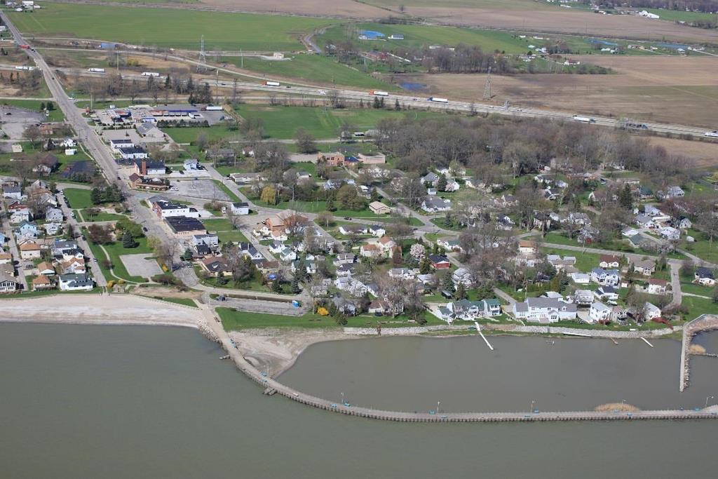
24 Brest Bay / Lower Raisin / Bolles Harbor 20


25 Lower River Raisin - Waterloo Park to Lake Erie General Description The lower five miles of the River Raisin flows through the historic City of Monroe. A series of low head dams and sometimes shallow water makes travel difficult during periods of low flow, but this part of the river still contains good fishing and natural beauty as well as an urban downtown and important historical sites. After portaging around the Waterloo Dam the river passes Veteran s Park on the left and the undeveloped Mill Race Park on the right, with its restored prairie and wildlife habitat. The city water tower and the large open area of Roessler Field, a school site, is on the left. Crossing under the Roessler St. Bridge is the first of four low-head dams which have been modified with rock arch rapids a large group of boulders placed in formation below the dam to facilitate fish passage. Depending the water levels and flow rate, it might be possible to float a boat over the dams or to get out and carry it through the boulders. The safest option would be to carry around on the shore on the north bank of all the low head dams. A large island in the river below the first dam will lead to the second dam at St. Mary s Park. Below this dam on the south bank is a large city parking lot with a fishing platform and a narrow river access spot just above this structure. The one mile stretch between St. Mary s Park and the next low head dam flows through the center of downtown, following the City s Riverwalk on the south bank. This area tends to be quite shallow and rocky during dry spells, but most of the year provides an interesting urban paddling experience and excellent fishing opportunities particularly for bass, but with the occasional steelhead, walleye, pike, catfish and other species. Passing under the Winchester St. Bridge and a series of railroad bridges leads to a boat ramp at Hellenberg Park on the right, just past the small walking bridge which connects the park to a small island. Waterloo Dam at Veterans Park Downtown Monroe No further dams or obstructions exist below the Hellenberg Park access site, and motorboats are present in the river from this point down. Cross under I-75 and in about half a mile will be the turning basin of the Port of Monroe, where paddlers might encounter Great Lakes freighters at the docks. Across the river from the turning basin is the River Raisin Marina, which offers camping, boat docks, and kayak 21


26 launching for a small fee. Paddlers should look for an opening at the low end of the marina for access under Elm Street, opening up into to wildlife areas and the state park to the north. The final mile of river is a deepened dredged channel leading out to Lake Erie through an industrial landscape, with a former Ford Plant to the north and the tremendous DTE Energy Monroe Power Plant to the south. Dredged channel leading to Lake Erie Interesting and Unique Features Anywhere along this segment of the lower Raisin River paddlers can find shops, restaurants, museums, historic structures and other amenities. Waterloo Park, Veteran s Park, St. Mary s Park and Hellenberg Park all have water and restrooms. Downtown Monroe is the scene of many festivals, including the annual River Raisin Jazz Festival. Across the river from Hellenberg Park is the River Raisin National Battlefield Park, part of the U.S. National Park system, which commemorates and preserves the site of an important War of 1812 battle. It is hoped that eventually an accessible landing will be developed, but for now the National Park is just a short walk over the Winchester Bridge from the boat landing at Hellenberg Park. River Raisin National Battlefield Park Although the lower mile of the Raisin is located within an industrial setting, the river continues to contain a natural shoreline on the north bank, and possesses important wildlife habitat, including nesting eagles and plentiful waterfowl. Between Sterling State Park and the river s mouth lies the Eagle Island (Ford) Marsh unit of the Detroit River International Wildlife Refuge. Although currently closed to the public, the marsh represents some of the important efforts being taken to restore coastal wetlands and wildlife habitat in western Lake Erie. Hazards and Warnings The lower two miles of the river contains motorboat traffic, with the upper limit being the low head dam below Winchester Street. Several small marinas line the river between the dam and I-75. Below I-75, there is occasional freighter traffic in the river and the turning basin. Large coal freighters unload at the docks of the power plant on the south bank near the river s mouth. 22

27 The river may be too shallow for canoes and kayaks during dry periods in the area surrounding the city s low head dams, but above Waterloo dam and below Hellenberg Park is always navigable. The Waterloo Dam at Veteran s park must be portaged, and it is recommended that the low head dams be portaged as well. Lake Erie at Monroe General Description Sterling State Park has a variety of kayaking opportunities, including a small bay and the open waters of the Great Lakes, a large protected lagoon, a secluded canal, and the lower part of the River Raisin. The best location for canoes and kayaks to launch is off the shore by the trailhead which is located by the pedestrian bridge which crosses over the lagoons. There are two floating fishing piers at the site, with the one to the north being the best place to launch from. The lagoons are about a mile long and a quarter mile wide but narrow to a small opening at the bridge. Both halves of the lagoon are popular with fishermen and also popular with migrating waterfowl. Recent restoration projects have eliminated much of the invasive vegetation, especially in the western pond, which is accessible only by carrying over the dike and trail that winds through the park. At the far southern end of the lagoon are the State Park campground and the opening that leads to Lake Erie. An opening from a lagoon in Sterling State Park leading to Lake Erie. This opening can also be accessed by launching from the developed and sometimes busy boat launch and circling around the point and past the beaches and campground a trip of about 2.5 miles. But using this launch allows the paddler to explore the wetland filled bay with its many small coves, inlets, and wetland areas. It is possible to head south on Lake Erie about ¾ of a mile past the campground to the mouth of the River Raisin, across from DTE Energy s Monroe Power Plant. However, a preferred alternative might be to find the canal at the southwest corner of the lagoon and head this way. This canal, lined on both sides with trees and grapevines, is known locally as the Clearwater Canal and ends near I-75, but once supplied water to Monroe s many paper mills. A little more than half a mile down the canal will be a newly created opening into a large pond and wetlands complex. These ponds can make for enjoyable 23
 and finally along the east edge of the River Raisin Marina and into the River Raisin.")
28 paddling, but to continue south through one of the two parallel channels will lead to an opening under the railroad tracks and the road (East Elm St.) and finally along the east edge of the River Raisin Marina and into the River Raisin. From the River Raisin it is possible to paddle up river against what is usually a fairly weak current and take out at Hellenberg Park s landing site, across the river from the National Battlefield Park. Or heading downriver, head back north into Lake Erie to return to Sterling State Park, or head south, past the power plant, to head into Plum Creek Bay or to continue south to Bolles Harbor. Bolles Harbor Interesting and Unique Features Sterling State Park has miles of nature trails, sandy beaches, camping, and picnic areas. It is an excellent place for viewing migrating birds during the spring and fall. The entire coastal area north of the River Raisin has been the subject of several different restoration efforts by both the State Park, the Michigan DEQ and the US Fish and Wildlife Service aimed at improving wildlife habitat, cleaning up past contamination, and restoring the hydrology which supports this rich area of biodiversity. Sterling State Park is connected to the River Raisin National Battlefield Park and to the City of Monroe by the recently established River Raisin Heritage Trail. This part of Lake Erie is known as Brest Bay and contains some excellent waters for fishing, particularly for walleye and perch. Some of the better fishing sites are located to the north of the State Park closer to Stony Point. Hazards and Warnings Parts of this trail are on the open waters of Lake Erie which can be dangerous and can change quickly. Sea kayaks are recommended for travel on the Great Lakes. Use caution in the waters surround the State Park boat launch, as there can be considerable motor boat traffic in this area. Use caution around the mouth of the River Raisin, as Great Lakes freighter traffic enters the river, docking at either the power plant or the Port of Monroe s turning basin. 24

29 Plum Creek Bay General Description Plum Creek Bay is an important shallow estuary where Plum Creek empties into Lake Erie. Fish and wildlife habitat, lotuses and other wetland plants, and good fishing make this body of water worth visiting, despite the difficult access. A public boat launch at Bolles Harbor leads on out into Lake Erie. South along the shore is a large residential area, but heading north, paddling around the diked US Army Corps confinement facility, is a small, somewhat protected shallow bay. Plum Creek Bay Following the coast north leads to a small sandy point (Raisin Point) at the channel leading into Plum Creek Bay. Paddlers should continue up the coast leading to the DTE power plant, but enter the channel and continue to the left after passing under a pipeline structure, as the channel to the right (north) is the power plants water intake canal. In Plum Creek Bay there are two heavily wooded islands by the north shore and a large island connected to the south shore by a causeway. This island is privately owned and is proposed to be developed into a campground and boating facility. Named Kausler s Island but known locally as Dog Lady Island, paddlers should contact Plum Creek Camping for information about how to put in or take out at this site. The bay continues under I-75 where it opens into a protected and secluded area under the jurisdiction of the Detroit River International Wildlife refuge. At the far northwest corner of the bay is the opening into Plum Creek. Plum Creek flows for over 15 miles through Monroe County before emptying into this bay, but only the lower half mile or so can be paddled. During periods of decent flow, a boat can be launched from Plum Creek Park in Monroe (off the end of Reisig Street at Ninth), although access is far from convenient at this location. Interesting and Unique Features To the north is the industrial Port of Monroe area and to the south is DTE Energy s ash disposal ponds, but Plum Creek Bay remains a vital natural area. 25

30 Off of Raisin Point is the Hot Hole - the location where the power plant discharges warm water into Lake Erie. Boats, swimmers and fishermen - as well as ducks and bald eagles - like to congregate in this area. The lotus beds in Plum Creek Bay are a popular place to see these rare plants when blooming in July. The Bolles Harbor neighborhood in Monroe Township contains several restaurants and taverns, as well as bait and tackle shops. Hazards and Warnings Parts of this trail are on the open waters of Lake Erie which can be dangerous and can change quickly. Sea kayaks are recommended for travel on the Great Lakes. Note that there may be heavy recreational boat traffic into and out of Bolles Harbor, which contains many privately owned marinas. The harbor is considered a harbor of refuge for boats on Lake Erie. Also note that near the southwest corner of the bay (west of I- 75) lies the Monroe County Detention Center, a part of the Monroe County Jail. Paddlers should not access this property. Access Site Inventory Waterloo Park Assets: Parking lot, picnic area, pit-toilet, shelter Boat Access Type: Developed, less than 50 yards Notes: Landing to east (down river) from fishing pier. Caution: Dam is ¼ mile down-stream and requires portage Veterans Park Assets: Lighting, parking lot, picnic area, restrooms, shelter, potable water Boat Access Type: Notes: Access the river at lower (east) end of park 26


31 Roessler Field Assets: Lighting, parking lot, picnic area, shelter, potable water, restrooms Boat Access Type: Carry-In, less than 50 yards Notes: Lauer-Finzel Lot Assets: Lighting, parking lot, picnic area, shelter Boat Access Type: Developed, less than 50 yards Notes: Access River at far western end of city parking lot on south bank of river, just west of fishing platform lot is connected by pedestrian bridge to St. Mary s Park which has restrooms and other amenities Sterling State Park Trailhead Assets: Lighting, parking lot, picnic area, shelter, potable water, restrooms, camping, power Boat Access Type: Developed, less than 50 yards Notes: DNR Owned (fee), launch on either side of pedestrian bridge at parking lot. Sterling State Park Assets: Lighting, parking lot Boat Access Type: Developed, less than 50 yards Notes: Primarily used for motor boats, launch is in small, protected bay. 27


, access sign, and busy site with")
32 Hellenberg Park Assets: Lighting, parking lot, picnic area, shelter, potable water, restrooms Boat Access Type: Developed, less than 50 yards Notes: Park contains grills, play area and fishing platform Plum Creek Park Assets: On-street parking Boat Access Type: Carry-In, less than 50 yards Notes: No parking in the park, creek maybe too shallow in dry periods, but deepens quickly downstream Bolles Harbor Assets: Lighting, parking lot, pit-toilet Boat Access Type: Developed, less than 50 yards Notes: DNR owned (fee), access sign, and busy site with motor-boat traffic 28
33 Recommendations Waterloo Park One of the first public parks in Monroe County to be upgraded to meet accessibility standards in the 1980s with its accessible pathways, picnic shelters, fishing pier, play area and exercise court, this park still lacks a well-designed landing facility. With its location just above the Waterloo Dam, being able to take out at this location is seen as an important aspect of a universally accessible water trail on the River Raisin. Veteran s Park Another public park on the River Raisin which has undergone improvements related to universal access, Veteran s Park does not have a designated launch/landing area below the dam, and does not have a well indicated portage trail to get around the dam. With the recent fish passage and other improvements, Veteran s Park, located at the upper end of the river s passage through the City of Monroe is seen as an essential launch site to take advantage of paddling opportunities within the more urbanized setting. A kayak launch is proposed in the City s most recent Parks and Recreation Master Plan, as is the proposed development of Mill Race Park, on the opposite bank of the river from Veteran s Park, which also includes a kayak launch and improved public access to the riverfront. Lauer-Finzel Lot With its small access area at the far western edge of this public park / parking facility, this area provides access for fishing and paddling in the center of Monroe. An improved slope as well as signage would make this location a well-used landing spot for taking advantage of the recent River Raisin Legacy project, the River Raisin Heritage Trail and other historic, natural and cultural assets of the community. Hellenberg Park With its existing boat launch facility, Hellenberg Park provides access for both motor boats as well as paddlers. Providing a fully accessible launch facility at this location is seen as especially important, as the park serves as a gateway to the lower Raisin, to Lake Erie and to Sterling State Park. 29
34 River Raisin National Battlefield Park Currently there are no direct river access sites at this internationally significant historic site, although plans exist to develop not only the existing National Park property, but to expand the public holdings into the River Raisin Heritage Corridor. An accessible canoe/kayak launch would be incorporated into this project, which has the goal of tying together the recreational, cultural, ecological, and historic assets of the community in order to increase the capacity for residents and tourists to enjoy them. It is likely that Hellenberg Park will continue to serve as the boat access site for this area of the river, which is proposed to be connected to the opposite shore and the main battlefield site with a pedestrian bridge. Lower Raisin There are currently no public access sites in the lower Raisin, a stretch of almost three miles downstream from Hellenberg Park. Although the River Raisin Campground and Marina offers access in this area for a fee, a public acquisition, possibly at the western edge of the Ford property would provide access to both the wetland areas on the State Park property and to the River Raisin through the canal across from the turning basin. Sterling State Park The State Park should develop accessible launch sites in the lagoon area of the park, which would provide access to both this protected water body, but also to the Clearwater Canal, the Union Camp Marsh, and to the River Raisin and Lake Erie. Although an accessible launch at the existing boat launch would be useful as well, the lagoon site would seem to be more useful for paddlers. Plum Creek / Plum Creek Bay Access to Plum Creek and Plum Creek Bay is severely limited. It is hoped that the US Fish and Wildlife Service will eventually provide public access to their holdings in this area for canoes and kayaks. At the upper end, the River Raisin Heritage Corridor project proposes to provide improved access to the creek from both Plum Creek Park and from a proposed open space corridor between Eastchester and Kentucky Streets. A public launch site off of Kauslers (Dog Lady) Island or at the end of Dunbar Road would also be of great benefit to paddlers wishing to explore this difficult to access resource. 30

35 Otter Creek / Toledo Beach / Luna Pier 31
 which terminates at a DNR parking area.")
.")
36 Otter Creek / Toledo Beach / Luna Pier General Description This trail traverses through a Great Lakes coastal community and some interesting backwater bays and up a small remote creek. The Muddy Creek access site is located at the end of the small and short gravel road (South Muddy Creek Road, although no sign was present) which terminates at a DNR parking area. A canoe or kayak can be launched off of the concrete and boulders at the edge of the creek. (Note that to the south is a nice state-owned pond containing water lilies and lotuses that makes a nice area to paddle around and explore). A similar state-owned pond is found on the north side on the DNR parking area at the end of North Muddy Creek Road, just on the other side of the creek, but access to this pond is a little more difficult due to brush and wetness. The creek flows under I-75 and empties into a large bay and wetlands complex (Allen s Cove). Straight across the bay is the busy Toledo Beach Marina on Lake Erie. Although the bay is too shallow for boat traffic other than canoes and kayaks, the marina has a small dock and landing in the far northeast corner of the bay by their clubhouse and swimming pool. Paddlers should contact the marina for information on accessing the bay from this location. Heading south across the bay, a channel opens up into Lake Erie. The channel opening is located at the far (northeast) end of the row of lakeside houses. Once in Lake Erie, a one mile long paddle south brings one to the opening of the protected area within the Clyde Evans Pier, and what is currently the county s only ADA accessible kayak launch. Going out from the Pier and heading south along the Lake Erie shoreline, after less than a mile will be the canal (LaPointe Drain) that leads to a public boat launch at the end of Harold Drive, just past the privately owned marina. Lake Erie coastline in the foreground and Allen s Cove on the background The coastal community of Luna Pier Interesting and Unique Features Luna Pier is a nice small coastal community worth visiting, with its swimming beaches, restaurants and cafes, replica lighthouse, and long fishing pier jutting out into Lake Erie. Its new kayak launch within the protected harbor gives beginners a chance to practice on calm waters before deciding to enter the more treacherous waters of the 32

37 open Great Lakes. The privately owned Toledo Beach Marina provides access to both Allen Cove Bay and directly on Lake Erie. The marina also has a restaurant and a small store. Contact the marina for more information. Allens Cove is part of the Erie State Game Area and is an important site for wetlands and wildlife within the coastal zone of Lake Erie. Both Allens Cove and the Muddy Creek access area are state owned land but as part of a state game area do not require the entry fee as do state parks or recreation areas. Hunting and fishing fees help pay for these sites. Hazards and Warnings Muddy Creek and the entire Allen Cove bay area tends to become very difficult to navigate due to emergent aquatic vegetation during the middle of summer. This portion of the trail may be best to visit in the spring and early part of the summer months, but also tends to vary depending on lake levels which are constantly changing. Parts of this trail are on the open waters of Lake Erie which can be dangerous and can change quickly. Sea kayaks are recommended for travel on the Great Lakes. Otter Creek General Description Otter Creek is a small but long creek draining directly into Lake Erie, the lower three miles of which is navigable by canoe and kayak. The creek widens considerably as it approaches Lake Erie, and has changes in character from a narrow creek to wide open waters with extensive wetlands on both shores, and finally emptying into the open waters of Lake Erie. Access to the creek from public land is limited to two locations. The upper portion of the creek can be accessed behind the LaSalle Township Hall. At the far western edge of the township hall property (behind what is formerly the fire hall) is a small clearing with a gradually sloping bank. However, there may be insufficient flow to launch here during dry periods. The other public access is in the middle of the three mile stretch of the Creek, by the Knab Road Bridge, which connects LaPlaisance Road on the north to South Otter Creek Road on the south. The southwest corner of the bridge abutment seems like the safest and easiest point to launch. Please stay close to the bridge, as it is surrounded by private property on all sides. Parking on the side of the road is permitted. Otter Creek, as it empties into Lake Erie 33

38 The current is generally gentle enough that if one launches at Knab Road, opportunities exist to paddle either upstream to the Township Hall (if deep enough) or downstream to Lake Erie. Erie Bay Harbor Marina, located just east of I-75 on the south shore, also provides access at it privately owned docks for a small fee. Rose Harbor Marina is about a mile north of the mouth of Otter Creek, located on Woodchuck Creek, about 1,000 feet inland from the shoreline. Launching from the public access site at Bolles Harbor requires about three miles of open water paddling before arriving at Otter Creek. Note that the mouths of both Woodchuck Creek and Otter Creek are marked by jetties on either side of their openings. Interesting and Unique Features Good fishing, quiet back country atmosphere, little traffic and plenty of bird life and other wildlife viewing opportunities make this an underappreciated paddling area. Otter Creek can also be accessed from Lake Erie, although the nearest public access sites on Lake Erie are several miles away, either to the north or south. If water levels permit, you can pull out at Trapperz Tavern located directly across the creek from the Township Hall. Enjoy their famous turtle soup and a cold beer. Hazards and Warnings Upper reaches may be too shallow for paddling during dry periods. It may be possible to walk down along the rocky riverbed to scope out conditions, as the creek quickly deepens downstream. In the lower part of the creek east of the I-75 Bridge, it may be safest to stay in the more scenic and natural northern edge of the creek, as all motorboat traffic will keep to the southern area where the water is deeper. East of the I-75 Bridge, it may be safest to stay in the more scenic and northern edge of the creek. 34


, can access creek and pond from the parking area.")

39 Access Site Inventory Please note that an inventory of the Bolles Harbor Launch Site was previously listed. LaSalle Township Hall Assets: Parking lot, restrooms, potable water Boat Access Type: Carry-In, less than 50 yards Notes: Launch at west edge of Township Hall, creek is shallow and may have to drag boat downstream during low water periods, restrooms and water available during business hours, restaurant and bar across the creek Knab Road Bridge Assets: On-street parking Boat Access Type: Carry-In, less than 50 yards Notes: Put in close to bridge, surrounded by private property Muddy Creek Access Site Assets: Parking (road-end) Boat Access Type: Carry-in Notes: Small parking area at end of short gravel road (no sign), can access creek and pond from the parking area. The pond is nice for beginners, heavy vegetation in the summer may make it difficult to paddle Clyde Evans Municipal Pier Assets: ADA launch, metered parking, lighting, picnic area, restrooms, shelter, potable water Boat Access Type: Developed, less than 50 yards Notes: Access sign in the water, only ADA Launch in Monroe County, site is near restaurants and shops at Luna Pier 35

40 Luna Pier Boat Launch Assets: Lighting, parking lot Boat Access Type: Developed, less than 50 yards Notes: $5 daily parking fee, access sign along the road, marina nearby, the dock and ramp is in the channel leading to Lake Erie Recommendations Otter Creek Access to this underused resource is limited to the LaSalle Township Hall and to the bridge at Knab Road, neither of which has been developed as public access sites for paddlers. The Township Hall site could use just some minor shoreline improvements to make launching more convenient, but this site is often too dry to serve as a high quality access site. The Knab Road site is not an ideal location either, as there is limited parking and a fairly steep decent to the creek from the road. A small property acquisition in this area from one of the adjacent landowners would allow for perhaps a small parking area, and a more convenient landing area. In addition, a landing in the lower part of the creek would most likely be well used by paddlers. There is a site at the end of LaVigne Road where it turns into N. Otter Creek Road that is used as a launch site, but is not on public property. Perhaps the township, the county, or the DNR could acquire a small piece of property or an easement to provide off-road parking and river access in this location. Muddy Creek/Allens Cove The State owned access at Muddy Creek is not well marked and would be improved by signage and an improved trail, both to the creek and to the state-owned ponds. The wetland complex at Allens Cove is easily accessed from private land at the Toledo Beach Marina, but public access is more limited. The City of Luna Pier owns property on the cove across from Watertower Park, and it might be possible to provide parking 36
41 and a launch site at this location. Paddlers could then have the option of paddling in the cove, upstream to the DNR access site, or out the cove s opening into the open waters of Lake Erie, just north of Luna Pier s pier and beach area. Luna Pier The Luna Pier boat launch could be improved by the addition of an accessible launch facility in this location. What is currently Michigan s only accessible launch site on Lake Erie is located at the pier in Luna Pier, but it has been suggested that this underutilized resource might be more useful if it were to be relocated to provide access to Allens Cove, as discussed above, and which would also serve paddlers wishing to access Lake Erie. Ideally, a new accessible launch could be developed at Allens Cove which would give the City the potential to have a series of three accessible sites, each one approximately one mile apart. 37

42 Erie / North Maumee Bay 38

 and another unimproved access site on")
43 Erie / North Maumee Bay General Description Michigan s southernmost Lake Erie coastline is made up of the shallow waters of North Maumee Bay, a long, sandy peninsula running parallel to the coast, extensive coastal wetlands and several small islands. The conditions in the protected areas of the bay are generally calm, but depending on wind speed and direction, it may get choppy on these wide open waters. There are two launch sites to access the bay directly the DNR s Halfway Creek boat launch at the end of Algonquin Road (a small dead end street off of Summit) and another unimproved access site on Flat Creek where it crosses Bay Creek Road (a parking area is about 500' south of the creek). The Halfway Creek launch seems more popular, but the Flat Creek site affords access to the Bay at the more protected northern end, which may be preferred during rougher conditions. In the City of Toledo s Point Place neighborhood is the Howard Pinkley Landing which consists of parking and a floating pier especially designed for launching canoes and kayaks. A two mile paddle down the Ottawa River leads to the south end of the bay in Michigan waters. Putting in at the City of Luna Pier s launch on LaPointe Drain, or at the carry-in beach access at the Consumers Energy s Whiting Plant at the end of Erie Road, lets one paddle south along the entire length of Woodtick Peninsula and then around North Cape and into North Maumee Bay. Although this is a long, open water trip, the beaches along Woodtick give numerous opportunities to pull ashore. The entire peninsula, with the exception of the power plant at its north end is public lands of the State of Michigan and part of the Erie State Game Area, as is Indian Island. Note that Gard Island is privately owned (University of Toledo) and access is not allowed. But Indian Island, which is mostly wooded, has some sandy beaches and is an interesting place to stop and rest. North Maumee Bay Howard Pinkley Landing (Toledo) 39

44 Interesting and Unique Features The Erie State Game Area is an important wildlife area consisting of lake plain prairies, emergent wetlands, woodlands, coastal marshes and other habitat types. The Erie Marsh Preserve is a private property owned by the Nature Conservancy but used by its original owner and donor, the Erie Shooting and Fishing Club, during waterfowl hunting season in the fall. Extensive restoration efforts are taking place to remove invasive plants and to improve the areas function as coastal wetland and wildlife habitat. Although not open to the public during the current restoration efforts, paddlers should contact The Nature Conservancy for more information on access. Both Gard Island and Indian Island, as well as Woodtick Peninsula, are considered important archeological sites and should be respected as such. Woodtick Peninsula Hazards and Warnings The channel between Woodtick Peninsula and the Erie Marsh Preserve has been dredged in the past by Consumers Energy as it serves as the raw water intake for the coal burning plant. However, the plant is slated to be decommissioned in the near future and the future of this channel is uncertain. Be warned that this channel area is said to be a popular area for waterskiing, but serves as the only way to access the more remote northern reaches of the bay, so exercise caution if paddling up this two mile long narrow channel. Paddlers should also note that Lake Erie, and especially North Maumee Bay, are subject to an interesting phenomenon known as a seiche. During prolonged windy periods, particularly from the southwest, water gets pushed into the lake s eastern basin causing strong waves and flooding, and on this side of the lake can cause what is normally a shallow bay to become almost a mud flat and difficult to paddle across. The water level can have a difference of over 15 feet between Michigan and Buffalo, New York on the far eastern end of the lake. Boats have been known to be stranded for several hours until the winds die down and the water refills this end of the lake. And a northeast wind can have the opposite effect, sometimes causing serious flooding in the western basin. Parts of this trail are on the open waters of Lake Erie which can be dangerous and can change quickly. Sea kayaks are recommended for travel on the Great Lakes. 40


, pit-toilets Boat Access Type:")
 Assets: Parking Boat Access Type: Developed, less than 50 yards Notes: Access sign")
45 Access Sites Please note that an inventory of the Luna Pier Launch Site was previously listed Erie Road Access Site Assets: Parking lot Boat Access Type: Carry-In, more than 50 yards Notes: The creek crosses Bay Creek Road ¼ mile north of where the road begins off the Summit Street entrance, parking is 200 ft. south of the creek. Little Lake Creek Access Site Assets: Parking Boat Access Type: Cary-In, less than 50 yards Notes: Halfway Creek Boat Launch Assets: Parking lot (and dead-end road), pit-toilets Boat Access Type: Developed, less than 50 yards Notes: DNR owned (fee), access sign visible from road Howard Pinkley Landing (Toledo) Assets: Parking Boat Access Type: Developed, less than 50 yards Notes: Access sign along the road, very easy to use float pier on Ottawa River approximately 1 mi south of the state line. 41
46 Recommendations The Erie Road access site has a fairly long walk from the parking area, about 300 yards. The future of this site is uncertain due to the projected decommissioning of the Consumers Power Plant at this location. However, closure of the power plant, as well as the cooperative management activities with the Fish and Wildlife Service in this area might present opportunities for an improved Lake Erie Access site as well as a new access site on the northern end of North Maumee Bay, which currently requires at least six miles of paddling to visit. Either of the DNR accesses sites could be improved by adding an accessible launch facility, with the Halfway Creek (Algonquin Road) site being the most suitable for improvements due to the larger parking area and existing restrooms. 42

47 Upper River Raisin 43

48 Upper River Raisin General Description The River Raisin is generally a gently flowing winding river with forested banks and floodplains, giving one the impression that they are far from the heavily farmed and settled landscape surrounding the river. Above the City of Petersburg, there are often many log jams and obstructions, but below the City, and definitely below Dundee, obstructions are uncommon. The river is often shallow, but has occasional deep holes and deep areas above the dam in Dundee. This nine mile stretch might take up to four hours to complete. Below Dundee, the River Raisin continues to wind gently through farm country, although from the water the heavily wooded shoreline gives one the impression of being in a more remote setting. Tall sandy bluffs line the shore in some spots and occasional logs, boulders, hanging grape vines and sandbars keeps the paddling interesting, as this stretch is nice for beginners and experts alike. The river begins to straighten out after three or four miles, and gets much deeper and slower as the Grape Dam at the end of this stretch is approached. Below Dundee, the River Raisin in an ideal stretch for beginner paddlers. Photo provided by paddle.net The only public land along this trip is the West County Park outside of Dundee, but it is tricky to access from the river due to the lack of a landing area and the swift and deep flow near the park s riverfront. The park contains lengthy trails through restored natural areas and is located where the high voltage power-lines cross the river about 1.5 miles below Dundee. There are restrooms and small picnic shelters in the park (no water) but the parking area where the restrooms are located is a short hike from the riverbank. The dam just above the Raisinville Township landing must be portaged around. Paddlers can pull out on the rocky landing on the left or on the grassy bank to the right. Both areas are private land, so paddlers need to be respectful and take out and put in as close to the dam as is safe. No roads cross the River between Dundee and the Ida-Maybee Bridge at the Raisinville Township Hall landing, although there are a couple of railroad crossings. 44

49 Interesting and Unique Features The river is not very heavily travelled due to the lack of access sites. Paddlers will likely enjoy peace and solitude along this beautiful stretch of the historic River Raisin. Both Petersburg and Dundee are historic small towns with shops, restaurants, public libraries and other facilities worth visiting. The Old Mill Museum at the dam in Dundee is in a structure once operated as a factory by Henry Ford and contains many interesting displays and artifacts. Between Dundee and Raisinville is the River Raisin Canoe Livery which has a dock and landing area, with shelters, camping, water and restrooms. Paddlers should call ahead to make arrangements, as they also offer a shuttle service, canoe and kayak rental and more ( ). The livery is located about 7 miles (2 ½ hours) below Dundee. Old Mill Museum in Dundee Hazards and Warnings There is a dam in Dundee that must be portaged around. The Wolverine Park boat launch is about 500 feet above the dam on the right. Exiting the river here means carrying your boat across M-50, crossing the bridge and putting in at the Village Hall boat ramp on the opposite bank, about a ¼ mile from the take out point. Many people find it easier to pull out on the left bank just above the dam near the public parking area by the red gazebo, and carrying your boat across the rocks to put in below the dam. Paddlers should exercise extreme caution near the dam, especially during high water periods. There is no public land or launch sites in the approximately nine miles between Petersburg and Dundee. Petersburg Road and US-23 are the only bridge crossings until M-50 in Dundee. 45


50 Access Sites City of Petersburg Treatment Plant Site Assets: Parking (road-end) Boat Access Type: Carry-In, less than 50 yards Notes: Hard to find, enter at DPW yard at end of Wood Street, continue down gravel road to near the treatment plant, parking on grass is permitted Wolverine Park Assets: Parking Boat Access Type: Carry-In, less than 50 yards Dundee Village Hall Assets: Parking lot, lighting Boat Access Type: Carry-In, less than 50 yards Notes: Restrooms and water is available at Village Hall or public library Raisinville Twp. Hall Launch Site Assets: Parking lot Boat Access Type: Carry-In, less than 50 yards Notes: Site under development, short walk from parking to rivers edge, river is shallow during low water periods but quickly depends down stream River Raisin Canoe Livery Assets: Parking, camping, lighting, picnic area, pit-toilet, shelter, potable water Boat Access Type: Developed, less than 50 yards Notes: Landing Fee: $10 for one, $5 per person (w/shuttle), $5 per boat 46
51 Recommendations Petersburg The City of Petersburg has a large but undeveloped publicly owned open space behind their waste water treatment plant that serves as a suitable launch site, but which lacks signage or amenities. A small dock or landing area could be developed along with clearer indications that the site is available for public use. Dundee Public access to the River Raisin both above Dundee, but especially below Dundee is severely limited. The stretch between Petersburg to Dundee is nine miles with no public access to the river. Dundee to Ida-Maybee Road is 9.5 miles with no public landing. And Ida-Maybee Road to Raisinville Road is another 5.5 miles. Possibilities exist for the development of a landing at West County Park in Dundee Township and possibly along North Custer Road in Raisinville Township. An additional access site would be useful not only for paddlers but for fishermen who wish to wade or fish from shore and for the general public to enjoy public land and open space along this scenic stretch of the river. Raisinville Township Hall Site Plans currently exist to improve access, parking and the landing area at this Township owned site at the Ida-Maybee Bridge. Additional opportunities exist to provide amenities such as picnic areas, restrooms, water, and an accessible launch facility. Such a facility could be developed in tandem with the two sites further downstream (Navarre Anderson Trading Post and Waterloo Park) to create a series of fully accessible river landings. 47

52 Central River Raisin 48

53 Central River Raisin General Description A peaceful stretch of generally gently flowing river, the Raisin in this segment is fairly shallow and flows over solid limestone bedrock for much of the way. Excellent bass fishing and wildlife sighting opportunities, the landscape slowly changes from a tree lined natural setting to a more urban setting, but still keeps its wide, open and rural character. This is about a three hour trip and would be considered and easy paddle for beginners, but still a scenic and enjoyable trip for anyone. Navarre Anderson Trading Post Interesting and Unique Features The upper half of this section is mostly wild and natural. There are no bridges or public land until Raisinville Road, about 5.5 miles from the beginning, although N. Custer Road and Dixon Road both come very close to the river at certain points. The Navarre Anderson Trading Post and Country Store is an important historic site with historic buildings, including one of the oldest wooden structures in Michigan. The Country Store is not a retail outlet but rather a former one room schoolhouse converted into a replica of a historic county store. Directly across the river is the main branch of the Monroe County Library System, which has restrooms and water during its regular hours. Canoes or kayaks can be pulled out on this rocky bank as well. Continuing downstream, Waterloo Park on the south (right) bank contains picnic shelters, grills, play and exercise areas, restrooms, and an accessible fishing pier. The shoreline is rocky, but look for a safe landing area just past the fishing pier at the far lower end of the park. Hazards and Warnings The Waterloo Dam at Veteran s Park is ¼ mile downstream from Waterloo Park and must be portaged around. Take out on left (north) side just before fish passage canal, and carry through this public park to a spot below the dam to re-enter the river. 49

54 Access Points Waterloo Park Assets: Parking lot, picnic area, pit-toilet, shelter Boat Access Type: Developed, less than 50 yards Notes: Landing to east (down river) from fishing pier. Caution: Dam is ¼ mile down-stream and requires portage Trading Post/Country Store Assets: Parking lot, lighting Boat Access Type: Carry-In, less than 50 yards Notes: Take out by bridge or at small inlet near wooden bridges or concrete block on bank. Public library across the street has restrooms Recommendations Navarre-Anderson Trading Post / Martha Baker Country Store This important historic property has tremendous potential for a launch and landing site. As it is already a developed public property with parking and high visibility, the site has had several previous projects aimed at universal access. A pathway leading to the river next to the bridge abutment as well as an accessible pier or launch facility would be an important asset to the community. Waterloo Park One of the first public parks in Monroe County to be upgraded to meet accessibility standards in the 1980s with its accessible pathways, picnic shelters, fishing pier, play area and exercise court, this park still lacks a well-designed landing facility. With its location just above the Waterloo Dam, being able to take out at this location is seen as an important aspect of a universally accessible water trail on the River Raisin. 50

55 Obstacles and Safety Concerns Kayaking and canoeing on the River Raisin and Lake Erie is a fun and exciting recreational activity. However, it is important for paddlers to understand what obstacles and hazards they might encounter and what precautions they need to take to ensure their safety while on the water. Safe paddling requires preparation (pre-trip planning), proper equipment, an awareness of the surroundings and experience. Obstacles - Fermi Nuclear Power Plant Paddlers should avoid paddling directly in front the Fermi PowerPoint whenever possible. Obstacles Because the River Raisin passes through some very urban environments, paddlers are required to portage around several man-made impediments (e.g., dams). Each dam along the Raisin River is identified on the Trail Section Maps that preceded this section. Other obstacles along the River Raisin and Lake Erie may be attributed to low-water levels or dense aquatic vegetation at certain times of the year. Safety Concerns Weather and Lake Conditions Paddling on Lake Erie can present serious challenges to inexperienced and experienced paddlers if they are unprepared. High winds and accompanying waves can easily swamp a kayak. High wakes trailing behind fast-moving, motorized watercraft can be equally dangerous. In addition, paddling far from shore can result in becoming disoriented and lost. Safety Concerns - Weather The NOAA website can provide current and forecasted weather related data to paddlers, including temperature, precipitation, wave height, wind speed and wind direction. Every effort should be made to educate paddlers on the potential risks and dangers of paddling Lake Erie. It is important for paddlers to keep the shoreline within sight at all times and, whenever possible, paddle with a buddy. It is also important for paddlers to check current and anticipated weather conditions before launching. Weather updates and real-time radar can be viewed on the National Oceanic and Atmospheric Administration (NOAA) website. Finally, it is important for paddlers to make sure someone staying ashore knows the route you plan to paddle and when you expect to return. 51

56 Shipping and Boating Traffic When paddling on Lake Erie (especially near the Port of Monroe), it is important for paddlers to be aware of freighter traffic. Although freighters can appear to be large and lumbering, they move much quicker than expected and may not be able to see smaller watercraft. When the need arises to cross a shipping or recreational boating channel, do so cautiously and quickly. High wakes trailing behind fast-moving freighters and motorized watercraft are dangerous and collisions can be deadly. If paddlers need to alter their route in response to an approaching vessel, standard boating procedure says they should steer starboard (to the right). Shipping Traffic Freighters move much quicker than they appear and may not be able to see smaller watercraft. International Waters Paddlers can freely cross the international boundary to explore the Canadian side of Lake Erie. However, paddlers who land (anchor, wade or touch the bottom with a paddle) are committing an illegal act, unless paddlers immediately report their arrival to Canadian Customs. Violation of international border crossing laws can result in severe penalties. For more information, visit River and Paddling Etiquette It is important to remember that the River Raisin and Lake Erie support a wide variety of recreational uses. People use these water resources to swim, fish, boat and paddle. It is also important to remember that most of the shoreline along these two waterways is held by private citizens, many of which believe the river (or lake) is an extension of their front yard. When interacting with local residents or other river/lake users, paddlers have a responsibility to be good ambassadors of the river/lake, the water trail and the paddling community. River Etiquette American Whitewater, a national non-profit organization created to protect and preserve whitewater rivers, has developed a fairly common sense set of guidelines for 52
57 paddlers regarding paddling on the water and traveling to and using river access facilities. Interacting with Local Residents and Other River Access Users Drive courteously and within the speed limit. Good driving etiquette, particularly in residential areas, is essential for maintaining positive relationships with those that live near paddling destinations Park in designated areas making sure not to block driveways or interfere with traffic Change clothes discretely Do not play loud music Follow the laws and rules of the area that you are using Consider taking a few minutes to pick up litter left by others Interaction with Paddlers In areas that are being fished, paddle past consistently with minimal interference. Interacting with Anglers Stay in the main flow whenever possible while paddling past anglers or while paddling in heavily fished waters Paddle past areas that are being fished consistently with minimal splashing Avoid shouting or being loud Avoid startling anglers. Pass anglers on a highly visible path down the river and make eye contact with the angler as far upstream as possible Don t approach casting anglers Interacting with Boaters At put-ins and take-outs, behave in a friendly, positive manner toward others and be helpful to those who might need assistance Allow for spacing up and downstream of others, particularly in a rapid, and seek to avoid collisions When entering a rapid, the upstream craft has the right of way. Those entering the current should yield to those already in it When exiting the current, avoid eddies that are full, if possible, and take care when entering occupied eddies When playing, avoid blocking navigation by yielding to oncoming, upstream craft. Exit a play spot after a reasonable time to allow someone else to use it. Always provide assistance to others who are in trouble or who are injured 53
, paddlers can virtually eliminate any direct impact to the river environment.")
58 Leave No Trace Paddlers typically have relatively small impacts on the river or lake environment. Most impacts occur when paddlers attempt to access the river or portage around large obstacles. By following the seven Leave No Trace Practices for River Corridors (see right), paddlers can virtually eliminate any direct impact to the river environment. The Leave No Trace Program is managed by the Leave No Trace Center for Outdoor Ethics, an educational, nonprofit organization dedicated to the responsible enjoyment and active stewardship of the outdoors by all people, worldwide. It is important to understand that Leave No Trace is best understood as an educational and ethical program, not as a rigid set of rules and regulations. Private Property Paddlers are encouraged to respect private land owners along the water trail routes. It should be assumed that all property is private unless otherwise noted. Paddlers should not stop and come onto private property, unless for an emergency. Best Practices To help the Monroe County Planning department and other and regional water trail partners plan, build and support a world-class water trail system, it can be helpful to examine best practices. The following section provides a brief summary of best practices regarding access sites, gear and equipment, safety and signage. The seven Leave No Trace Practices for River Corridors 1. Plan ahead and prepare 2. Travel and camp on durable surfaces 3. Dispose of waste properly (pack it in, pack it out) 4. Leave what you find 5. Minimize campfire impacts 6. Respect wildlife 7. Be considerate of other visitors Access Sites The National Park Service publication Prepare to Launch provides a comprehensive set of guidelines for assessing, designing and building access sites. Access Sites In 2014, the River Management Society, in collaboration with the National Park Service Rivers, Trails and Conservation Assistance Program, published Prepare to Launch, a comprehensive set of guidelines for assessing, designing and building access sites for carry-in watercraft. The following section highlights some of the guidelines outlined in the document, which can be found at 54


59 According to the NPS publication, there are four primary areas to address regarding a launch site: How will access be achieved? Which site location is most appropriate? Where are likely funding sources? Which environmental issues need to be addressed? Access Sites and Accessibility According to the NPS publication, paddlers of all abilities want to launch and land smoothly without capsizing or damaging their watercraft. In order to do so, paddlers need firm surfaces that support their movement and sufficient space to accommodate the length of their watercraft during put-in and take-out. In addition, paddlers must be able to stabilize their watercraft during transition to and from the water. The recommendations for designing a launch that addresses the need of paddlers with disabilities are: Height Above Water: Between 9 and 2 from the highest expected water level Width: At least 5 wide, preferably 6 to 12 Length: At least 25 to allow paddlers dry access to entire length of their watercrafts Slope: Below 8.33%, the federal universal trails guideline, whenever possible In addition to the launch standards outlined above, it is important for trail planners and site managers to consider universal accessibility in the design of the entire access site. For example, parking lots should have unobstructed and accessible parking spaces, the pathway to the water should be level and clear of debris, signs should be at wheelchair level, and restrooms should be accessible. Not every access site along the water trail will readily accommodate accessible features (e.g., rural road endings). However, in areas where access to the water is being provided at public parks, accessibility should be a goal. Accessible Launches EZ Dock, a Michigan company, is one of the leading manufacturers of accessible launches in the United States. Manual launches like the one pictured below in St. Clair (A) can be purchased for around $15,000. Larger, automated launches like the one pictured here in Wyandotte (B) cost around $30,000. A B 55

60 Figure 1.2 illustrates a universally accessible water access site. Information and advice on how to implement universal accessibility in the design of a water access site can be provided by Cindy Burkhour of Access to Recreation, Michigan s foremost leader in recreational accessibility. Figure
61 Site Location Appropriateness The size, design and features of the launch should be consistent with and appropriate for the surrounding physical and natural characteristics of the access site. The flow and general condition of the water body will also influence the location and design of the launch. Choosing an appropriate site will enable the installation of a launch that is inexpensive, long-lasting, and environmentally sensitive. The Seven Site Location Characteristics for a Best Suited Launch 1. Is constructed in accordance with applicable regulations, particularly the accessibility requirements 2. Provides safe access away from potential hazards at various water levels and minimizes user conflict 3. Can withstand flow levels, currents and exposure to elements 4. Designated with consideration for multiple types of users and the carrying capacity of launch, parking and waterway 5. Provides a firm surface for launching, despite changes in sedimentation levels 6. Will not be easily damaged due to climatic or seasonal conditions 7. Does not cause damage to riparian habitats or vegetation during construction and is unlikely to cause environmental impacts over time Cost Considerations The cost of designing and constructing the launch will largely depend on the complexity of the access site. While the launch design should be as simple as possible, the potential for erosion, high use, and steep banks are just a few examples of factors that may require a more complex design. Further costs may be incurred to make the entire access site universally accessible. Cost-saving Design Tips 1. Minimal Construction: Keeps cost low and helps maintain a natural appearance along a shoreline. If construction is necessary, durable materials will reduce the need for later repairs or replacement. 2. Weathering Impact: The speed at which materials weather will depend on climatic factors and level of exposure to currents and winds. 3. Existing Structures: In some cases, existing docks used by motorized boats can provide stable surfaces for paddle craft access. 4. Minor Modifications: Some docks may be modified to make them more paddlerfriendly, including being lowered, lengthened or widened. 5. Shoreline Features: Features such as boardwalks can be combined with floating docks to enable the launching of handcarried craft. Environmentally Friendly Launch Considerations The use of low-impact design is important to the overall health of the site and waterbody. For example, vegetative buffers and the use of pervious pavement should be considered in the siting of parking lots, and non-toxic materials should be used whenever possible. 57
62 Gear and Equipment Before going out on the River Raisin and Lake Erie it is important that paddlers have the right gear and attire. The most important item is the life jacket. It is imperative that paddlers always wear a properly fitting U.S. Coast Guard-approved life jacket. It is also important to bring at least two signaling devices, such as a whistle or waterproof flashlight. Reflecting tape, placed on the handle of the paddle or jacket, is a simple but helpful signaling tool. Pack personal gear (including a first-aid kit and cell phone) in a waterproof bag or container. It is also important for paddlers to dress appropriately for weather and water conditions, including varying air and water temperatures. Paddlers should expect to get wet at some point in the trip, so it is important to wear clothing that can get wet. Protective footwear is advised, especially when paddling on certain sections of the River Raisin. During the shoulder seasons when water is cooler, paddlers should wear a wet/dry suit that preserves body heat in case of sudden immersion. The American Canoe Association (ACA) has developed a fairly comprehensive checklist of equipment it recommends paddlers consider prior to a paddle trip. A Float Plan Lifejacket Spare Paddle Hat or Helmet Compass and Map Whistle or Sound Device Throw Bags or Rescue Gear River Knife Bilge Pump or Bailer Self-Rescue Device Sunscreen Drinking Water & Snacks A Light or Signal Proper Footwear UV Eye Protection First Aid Kit Small Repair Kit (w/duct Tape) VHF Radio & GPS Locator Personal Floatation Device (PFD) - Life Jacket There are five categories of PFDs, but most paddlers should use a Type III or V USCG (Coast Guard) approved PFD. Type I: Offshore Life Jackets. These are geared for rough or remote waters where rescue may take a while. Though bulky, they have the most buoyancy and can turn most unconscious people face up in the water. Type II: Near-shore Vests. Calm inland waters, where a fast rescue is likely, is the intent of these PFDs. They will turn some unconscious wearers to the face-up position but not all of them. * Type III: Flotation Aids. These are suitable for most paddlers where there is a chance for a quick rescue. They offer freedom of movement and the most comfort for continuous wear. Type IIIs are designed so wearers can put themselves in a face-up position, but they may have to tilt their head back to avoid being face down in water. Type IV: Throwable Devices. Cushions or ring buoys are designed to be thrown to someone in trouble and provide backup to a PFD. They are not for non-swimmers, rough waters or the unconscious. The USCG does not require these for canoes or kayaks. * Type V: Special-use Devices. These are specialized PFDs for specific activities. To be acceptable by the USCG, they must be used for the activity specified on the label. 58

63 There are many different types of kayaks and selecting one should be based upon a paddler s skill level, how far s/he will typically paddle, and the type of water in which s/he will typically paddle. In general, a kayak s hull size and shape greatly determines its performance characteristics. A brief description of kayak types and their attributes is listed at right. Figure 1.3 illustrates the components of a typical kayak. Length. As a rule, short kayaks (up to 12 feet) turn easier while longer kayaks (13 feet and over) track and glide easier. Keep in mind that it s actually the length of a boat s waterline (the line where the boat actually sits in the water) that is most important. A boat waterline may be significantly shorter than its overall length. Width. Wide boats offer more initial (primary) stability in calm conditions while narrower boats go faster and offer better secondary stability if the boat is leaning on its side. Depth. A touring kayak s depth (the height from the hull to the top of the deck) can be 13" to 16". On sit-on-tops, depth can measure from 11" to 16". Larger and taller paddlers should check for ample depth to ensure enough space and legroom. Taller sides help also deflect water and may help provide more storage space. The downside is that they catch more wind which can slow you down. Figure 1.3 A Brief Guide to Kayaks Shorter Kayaks Easier to turn and maneuver. Able to make quicker turns. Best for estuaries, small lakes, rivers; less suitable for long trips. Weigh less. Less affected by winds. Less cumbersome to transport. A bit slower. Good for kids and small adults. Longer Kayaks Easier to paddle over long distances (once you get them up to speed). Able to hold a straight line better to stay on course. Best for open water; good on smaller bodies of water. A bit heavier. Able to carry heavier loads with less performance loss. Glide farther per stroke for greater efficiency. Move faster. Hold more gear. 59

64 Safety Through its Operation Paddle Smart Program, the U.S. Coast Guard has identified 11 keys to safety for paddlers (see below). More information about the Operation Paddle Smart Program and a complete paddler s safety checklist can be found at the Coast Guard website, Safety Tips Wear USCG-approved life jackets Know weather conditions and take appropriate precautions Know the water temperature and the effects of cold water immersion Get information on waters where you will be canoeing or kayaking and take appropriate precautions Have emergency supplies or safety equipment Know and abide by the rules of the road Wear appropriate clothing Know and meet legal requirements for where you are canoeing or kayaking Stay with you craft if you unintentionally fall out of your canoe or kayak Submit float plans Have an emergency action plan Before paddlers get on the water it is important to make a plan and give it to someone who is staying onshore. It is important to include the names of the people in the party, the time and location of departure, the anticipated route, and the time the group is expected to return. It is also important to check in once the trip is finished so people know the group has arrived home safely. Non-Motorized Vessel Ownership Stickers Having the owner s contact information affixed to the kayak can help the Coast Guard and others determine the status of the vessel. This enables any drifting vessel to be returned to its rightful owner and greatly reduces unnecessary search and rescue expenses. When an unoccupied kayak or canoe is found in the water, the Coast Guard and local/state boating authorities often can t be immediately certain if they have an actual search-and-rescue case for a missing person or if the vessel simply drifted off from shore. Having the owner s contact information affixed to the kayak can help the Coast Guard and others determine the status of the vessel. This also enables the drifting vessel to be returned to its rightful owner and greatly reduces unnecessary search and rescue expenses. Stickers are available through the U.S. Coast Guard Auxiliary, U.S. Power Squadrons and the American Canoe Association. 60
65 Monroe County officials and local stakeholders should work with local Coast Guard Auxiliary offices to promote the use of and help distribute these vessel ownership stickers to paddlers. Emergency Assistance Due to the large geographic area in which the River Raisin and Lake Erie Trail water trails are located, there are numerous public agencies that will provide assistance to paddlers in need of emergency assistance. Monroe County officials should continue to work with local stakeholders, local officials and public safety officers from each jurisdiction along the River Raisin and Lake Erie to help coordinate a unified assistance program. One component of such a program may include the development of a unified rescue marker system. The signs are fairly inexpensive and provide lifesaving assistance for paddlers and first-response workers. Leveraging Trails for Economic Development As mentioned earlier in this document, water trails can have a significant impact on the local economy. Trails can help attract and support tourism and new business opportunities. In addition, local residents often spend money on trail-related activities and related businesses. In 2006, Michigan Sea Grant found that in the Midwest, $1.78 billion was spent on trip-related activities by paddlers and that gear-related spending totaled $433 million. As the link between trails and economic development is better understood, many communities are looking for ways to capitalize on their current trail networks to maximize trail-based tourism and future economic development opportunities - to redefine the community as a Trail Town. The Trail Town Concept Communities are realizing the economic potential of trails as highly desirable destinations that bring dollars into the places they serve trails and greenways attract visitors from near and far visitors who facilitate job growth in tourism-related opportunities like restaurants, local stores and lodging. Communities are increasingly utilizing this Trail Town model of economic revitalization that places trails as the centerpiece of a tourism-centered strategy for smalltown revitalization. Excerpted from a 2007 article published by the Rails to Trails Conservancy 61

66 The Trail Town concept was developed by the Allegheny Trail Alliance, a coalition of seven trail organizations along the Great Allegheny Passage, a 150-mile multi-use trail running through Pennsylvania and Maryland. According to the Allegheny Trail Alliance, a Trail Town is: A destination along a long-distance trail. Whether on a rail trail, towpath, water trail, or hiking trail, trail users can venture off the trail to enjoy the scenery, services, and heritage of the nearby community with its own character and charm. It is a safe place where both town residents and trail users can walk, find the goods and services they need, and easily access both trail and town by foot or vehicle. In such a town, the trail is an integral and important part of the community. 1 The Trail Town Concept Many businesses are already accommodating paddlers at their establishments. A Trail Town is an active, attractive, and interesting place with accessible and comfortable spaces, hosting a variety of activities and promoting social interaction and a strong sense of place. A Trail Town should meet both the needs of the trail users and the residents of the community. A Trail Town has the physical amenities that support trail users such as wide sidewalks, drinking fountains, and benches with shade. A Trail Town also has the business amenities to support day-trip trail users (such as a kayak outfitter and ice cream shop) and overnight trail users (such as a hotel, casual restaurant and laundromat). Within the region, the Clinton River Watershed Council recently created a WaterTowns program. Based on the same principles of the Trail Town concept, the WaterTowns program is focused on leveraging riverside and coastal assets for wateroriented community development. These efforts coincide with other Trail Town planning efforts in communities along the Huron River Water Trail and the Blueways of St. Clair. Monroe County officials should explore ways to implement a similar WaterTowns program in communities along the River Raisin and Lake St. Erie coastline. 1 Trail Towns - Capturing Trail Based Tourism, A Guide for Communities in Pennsylvania. Allegheny Trail Alliance (2005) 62
67 Using the basic elements of the Trail Town strategy (listed below), the Monroe County officials can help create a local and regional tool for water-trail-based community and economic development. Basic Elements of a Trail Town Strategy Entice trail users to get off the trail and into your town. Welcome trail users to your town by making information about the community readily available at the trail. Make a strong and safe connection between your town and the trail. Educate local businesses on the economic benefits of meeting trail tourists needs. Recruit new businesses or expand existing ones to fill gaps in the goods or services that trail users need. Promote the trail-friendly character of the town. Work with neighboring communities to promote the entire trail corridor as a tourist destination. Facilities and Infrastructure Access Sites and Amenities In order to have a safe and well utilized water trail, it is important to have safe and legal launch and landing sites along the water trail. A general guideline for urban water trails is that there should be an access site about every two miles - for more remote areas, the standard is five miles. Along the River Raisin, there are several areas where the distance between access sites is greater than five miles. Monroe County should continue to work with local jurisdictions along the water trail to add additional access sites where gaps exist. Access Sites Amenities In many instances, the access site (or trailhead) is the point at which the trail user will first come into contact with the community. Therefore, it is imperative for local jurisdictions to make the trailhead a positive and welcoming experience. In an effort to maintain a consistent identity along the water trail, Monroe County officials and local jurisdictions should work together to place interpretive kiosks at all major water 63
68 trail access sites. Any future template should incorporate wayfinding elements (including a map) and interpretive elements (e.g., watershed information, safety tips, paddling etiquette). In addition, for those access sites near a downtown, there should be a kiosk with a brief description of the downtown and its amenities (e.g., restaurants, businesses, etc.). In addition, by providing such amenities as potable water, kayak storage and bathroom facilities at the access site, the community welcomes visitors, showing hospitality and inviting them to revisit the trail and community. One of the most important amenities for any trailhead is a bathroom. Bathrooms not only provide toilet facilities, but often they are used by trail users to fill water bottles, freshen up and change clothes. Many jurisdictions close their traditional brick-andmortar bathrooms in early fall and open them in late spring. If shoulder-season access to a traditional bathroom is not possible, it will be important to provided portable (and accessible) bathroom facilities. It will also be important to provide kayak lock-up or storage facilities at access points. Due to the number and often remote location of access sites along some areas of Lake Erie, it is probably not feasible or even appropriate to have restroom facilities or other trailhead amenities located at each site. However, Monroe County officials should work with local jurisdictions to provide for these amenities if the access site is within close proximity to a downtown or primary tourist destination Signage To minimize confusion and provide a cohesive experience for paddlers and trail tourists, Monroe County officials should continue to work with local and regional partners to provide for navigational signs along the trail. In addition, the Monroe County officials should work with local jurisdictions and regional transportation agencies to place water trail wayfinding signs in strategic locations throughout the surrounding road network. Navigational signs placed at road crossings can provide paddlers with a sense of their location within the context of the trail network and region. By placing the mileage 64

69 (distance from the water trail s origin) on the sign, paddlers can better decide how long and how far to paddle. Wayfinding signs are one of the most important public amenities local jurisdictions can provide for citizens, tourists and visiting trail users. Wayfinding signs are designed to direct visitors to the primary assets and features of the community and the water trail should be treated as such. If possible, the name of the trailhead should be listed in the wayfinding sign. It would also be important to include the water trail logo developed under this planning effort in all wayfinding signage. Wayfinding Signs Whenever possible, the name of the access site and the water trail logo should be included in all community wayfinding elements. The picture below is an example of such wayfinding in Spring Lake, Michigan. Promotion To minimize confusion and provide a clear and cohesive image and experience for residents, paddlers and trail tourists, Monroe County officials should work with local agencies and organizations to develop a coordinated marketing program. These efforts should also tie into local and regional economic development programs whenever possible. As previously mentioned, there are several downtowns located directly on the River Raisin and Lake Erie. For local residents and trail tourists, access sites located within and adjacent to these downtowns serve as a portal to the water trail. At the same time, these access sites serve as a portal to the downtown for visitors coming via kayak or canoe. It will be important for Monroe County officials to work with Downtown Development Authorities (DDAs), downtown business organizations, and chambers of commerce to cross-promote downtown businesses and the water trails. Special events, especially events that tie into the community s history and cultural identity (or even the river and lake identity) can attract both local resident and visitors. Annual events that include a trail activity and downtown activity (e.g., a paddle in the afternoon and a BBQ with music at a local brewery) held just before the trail season kicks off can attract potential trail users into the community. Presentations, displays, and/or workshops (e.g., a program on how to how to buy the appropriate gear), or a tour of the water trail are other examples of activities that could be included in a local event. 65
Healthy River$ Economic Impact of the Huron River. Elizabeth Riggs Michigan Watershed Summit 28 March 2018
 Healthy River$ Economic Impact of the Huron River Elizabeth Riggs Michigan Watershed Summit 28 March 2018 Founded in 1965, HRWC protects and restores the river for healthy and vibrant communities. A
MEMORANDUM. Existing Operations. City of Clearwater. Michael Herrman. Date: January 26, Seminole Boat Launch Overview. M&N Job No.
 1509 W. Swann Avenue, Suite 225 Tampa, FL 33606 (813) 258-8818 Fax (813) 258-8525 www.moffattnichol.com MEMORANDUM To: From: City of Clearwater Michael Herrman Date: Subject: Seminole Boat Launch Overview
Androscoggin River Trail Access Sites. Mahoosucs. 168 miles from its source at Lake Umbagog to Merrymeeting Bay
 Androscoggin River Trail Access Sites Mahoosucs 168 miles from its source at Lake Umbagog to Merrymeeting Bay Trail Under Construction More than 40 Public Access Sites Available Androscoggin River Watershed
Launch Site Accessibility Evaluation & Design Recommendations
 Access Recreation Group, LLC Cindy Burkhour, MA, CTRS, CPRP 2454 Lamplighter Drive, Jenison, MI 49428-9127 Phone (616)669-9109 Mobile (616)560-2378 AccessRecreationGroup@juno.com Location: New Buffalo
Florida s Circumnavigational Saltwater Paddling Trail (CT)
") Florida s Circumnavigational Saltwater Paddling Trail (CT) Doug Alderson, Assistant Bureau Chief Florida Office of Greenways and Trails Division of Recreation and Parks CT Trail History Late 1980s Idea
Florida s Circumnavigational Saltwater Paddling Trail (CT) Doug Alderson, Assistant Bureau Chief Florida Office of Greenways and Trails Division of Recreation and Parks CT Trail History Late 1980s Idea
Iowa Department of Natural Resources Iowa Water Trails Grant Program
 Iowa Department of Natural Resources Iowa Water Trails Grant Program Submitted by the City of Story City in conjunction with the Skunk River Paddlers and the Story County Conservation Board Tuesday, January
Cat Island Chain Restoration
 Cat Island Chain Restoration 1820s Fox River Military Road Map to Fort Howard 1845 Chart of Green Bay & Fox River Cat Island Chain - 1938 Cat Island Brown County Aerial Photography, 1938 Historic Western
The Economic Importance of Recreational River Use to the City of Calgary
 The Economic Importance of Recreational River Use to the City of Calgary Prepared by: Calgary River Users Alliance May 20, 2016 The Economic Importance of Recreational River Use to the City of Calgary
Coastal and marine recreation in New England is ingrained in the region s economic and
 RECREATION Coastal and marine recreation in New England is ingrained in the region s economic and social fabric. Recreation on the ocean and coast includes many of New Englanders most time-honored and
Perryville TOD and Greenway Plan
 Perryville TOD and Greenway Plan Greenway Glossary Pathway: A bicycle and pedestrian path separated from motorized vehicular traffic by an open space, barrier or curb. Multi-use paths may be within the
VIDEO AUDIO Slide 1. Slide 2 Old timey 18 th century map of east coast
 VIDEO AUDIO Slide 1 1A Welcome to the Cooper River Rediversion Project at St. Stephen, Montage of exteriors of facility, South Carolina! Since 1985, this boating, fish runs, fishing, facility has served
About Rend Lake Marina:
 PRICE GREATLY REDUCED TO $1,495,000.00 For Sale: Rend Lake Marina plus 18 Contiguous Waterfront Acres for Development (Approved by the US Corp of Engineers). Rend Lake Marina 8955 West Dam Lane Benton
Issues facing this region include the status of the Sluice Creek tide gates, various tidal wetlands, and locations of public access:
 5.6 Guilford Point to Madison Town Line Existing Resources This region extends from Guilford Point to the Madison town line. Named places include Grass Island and the East River. Residential, commercial,
ROUTE 2. Bateau Channel. Topographic Map 31 C/8 Navigation Charts 1438/39 Reference Maps
 Topographic Map 31 C/8 Navigation Charts 1438/39 Reference Maps ROUTE 2 Bateau Channel The shoreline marshes of the Bateaux Channel team with life. Wetlands provide breeding habitat for amphibians, fish
Narrows West. Lots For Sale Overview
 Lots For Sale Overview Spring/Summer Sales Book 2017 My family has been living at the Lake Manitoba Narrows for approximately 100 years. One of my grandfathers settled on the west shore of the Narrows
RECREATION. in the St. Paul District. Your safety is our concern ALWAYS wear a LIFE VEST
 RECREATION in the St. Paul District Your safety is our concern ALWAYS wear a LIFE VEST Cross La RECREATION in the St. Paul District CANADA NORTH DAKOTA Lake of the Woods Homme Lake Devils Lake Red River
Columbia Lake Dam Removal Project
 Columbia Lake Dam Removal Project The Columbia Lake dam located 1/4 mile upstream of the Paulins Kill River's confluence with the Delaware River in Knowlton Township, Warren County has been proposed for
Canal Dock Boathouse, Inc. (CDBi) Paddle-Sports Request for Proposal Q & A Posted to CDBi website 9/16/2017
 Paddle-Sports Request for Proposal Q & A Posted to CDBi website 9/16/2017") Canal Dock Boathouse, Inc. (CDBi) Paddle-Sports Request for Proposal Q & A Posted to CDBi website 9/16/2017 *(All responses below are subject to further scrutiny by the City of New Haven and could be updated
Canal Dock Boathouse, Inc. (CDBi) Paddle-Sports Request for Proposal Q & A Posted to CDBi website 9/16/2017 *(All responses below are subject to further scrutiny by the City of New Haven and could be updated
DRAFT. System Components. Greenway Trails. Introduction. Trail Types. Zebulon Greenway Master Plan
 5 System Components Wakefield Street Photo Simulation showing Sharrows Introduction The Master Plan identifies various system components that, together, create a comprehensive greenway system. These components
Canoe Trip # Maps: 63L Amisk Lake 63M Pelican Narrows
 Canoe Trip #51 49 Southeast Arem Deschambault Lake - Pelican Narrows - Wunehikun Bay - Attitti Lake - Belcher Lake - Mukoman Lake - Ohoo Lake - Mukoman River - Sokatisewin Lake - Sandy Bay 170 Kilometers
Of the following, which best describes you?
 Summary of Downtown Des Moines Dam Debate April 26 th, 2016 The following are the responses we heard from participants in the Dam Debate cohosted by the Register and the Des Moines Area Metropolitan Planning
HARBOR INFRASTRUCTURE INVENTORIES Marquette Harbor, Michigan
 HARBOR INFRASTRUCTURE INVENTORIES Marquette Harbor, Michigan Harbor Location: Marquette Harbor is located in Marquette Bay on the south shore of Lake Superior, 160 miles west of Sault Ste. Marie, MI and
CLEARWATER COMPREHENSIVE BOATING PLAN PUBLIC OUTREACH MEETING 2. December 16, 2015
 CLEARWATER COMPREHENSIVE BOATING PLAN PUBLIC OUTREACH MEETING 2 December 16, 2015 Introduction Project Team City of Clearwater Bill Morris Director of Marine and Aviation Kyle Brotherton Planning and Development
Bicycle and Pedestrian Facilities Toolbox (Excerpt from Figure 3.1)
") Appendix B Neighborhood Connections Summaries This Appendix is a supplement to the information presented in Chapter 3 Connect People. The Appendix includes a summary or profile for each of the proposed
Appendix B Neighborhood Connections Summaries This Appendix is a supplement to the information presented in Chapter 3 Connect People. The Appendix includes a summary or profile for each of the proposed
Comments The Plan for Port Whitby
 Comments The Plan for Port Whitby April 24th, 2013 Community Meeting #2 Summary Report Prepared by GLPi April 29th, 2013 1 Introduction The purpose of the Port Whitby Secondary Plan Update, Community Improvement
Quay County, New Mexico 160 deeded acres; (MOL) $420,000
 $420,000") Quay County, New Mexico 160 deeded acres; (MOL) $420,000 Turn your steers out and watch them gain! FARMING House Ranch offers 60 acres of water rights This region of New Mexico just east of Tucumcaro
Quay County, New Mexico 160 deeded acres; (MOL) $420,000 Turn your steers out and watch them gain! FARMING House Ranch offers 60 acres of water rights This region of New Mexico just east of Tucumcaro
Restoring the Iconicc Lower Cache River
 Restoring the Iconicc Lower Cache River A new chapter holds promise of revitalizing cherished waters and woods The story of conservation in the lower Cache River and surrounding Big Woods of eastern Arkansas
Highland Region MAP. No. 11 St. Marys River No. 12 West River No. 13 Wallace River No. 14 Toney River No. 15 Northumberland Strait
 Highland Region MAP No. 11 St. Marys River No. 12 West River No. 13 Wallace River No. 14 Toney River No. 15 Northumberland Strait 14 Route: No. 11 St. Marys River Rating: Intermediate Advanced Length:
Chapter I: Marine Resources
 NOTE TO READERS: This is a draft of the Kennebunk Comprehensive Plan. The Comprehensive Plan provides us with a description of the town today in a range of categories, and identifies issues and recommendations
RLRC COMMUNITIES EAST GRAND FORKS AREA CHARACTER THE RED LAKE RIVER & THE RED RIVER OF THE NORTH CONFLUENCE EAGLE POINT BOAT LAUNCH DESIGN
 AREA CHARACTER THE RED LAKE RIVER & THE RED RIVER OF THE NORTH CONFLUENCE EAGLE POINT BOAT LAUNCH DESIGN DESIGN DETAILS 135 AREA CHARACTER East Grand Forks a city of 7,501 people is located across the
Roanoke River Blueway
 Roanoke River Blueway Roanoke River Currents Conference Friday October 9, 2015 Ferrum College Shane Sawyer, Regional Planner Roanoke Valley - Alleghany Regional Commission Roanoke River Blueway www.roanokeriverblueway.org
*Sandy Point State Park Paddling Routes
 *Sandy Point State Park Paddling Routes *Paddleboards are crazy popular in Anne Arundel County creeks and rivers. The life guards on this park s beaches have paddleboards to use in recusing swimmers. Not
Spearfish Canyon State Park & Bismarck Lake
 Spearfish Canyon State Park & Bismarck Lake Land Exchange Between the U.S. Forest Service and the State of South Dakota July 12, 2016 Background In 2006, the State of South Dakota received title to several
PEDESTRIAN ACTION PLAN
 ATTACHMENT 2 CITY OF SANTA MONICA PEDESTRIAN ACTION PLAN CITY OF SANTA MONICA PEDESTRIAN ACTION PLAN This page intentionally left blank EXECUTIVE SUMMARY CHAPTER 1 EXECUTIVE SUMMARY Setting the Stage
Cross Street Corridor Non-Motorized Enhancement Project Project Description
 Cross Street Corridor Non-Motorized Enhancement Project Project Description A cooperative study of the Cross Street neighborhood was completed in May 2002 by the City of Ypsilanti, the Depot Town Downtown
Crawford Reservoir. FISH SURVEY AND MANAGEMENT INFORMATION Eric Gardunio, Fish Biologist Montrose Service Center
 FISH SURVEY AND MANAGEMENT INFORMATION General Information: Crawford Reservoir is a popular fishery that provides angling opportunity for yellow perch, channel catfish, northern pike, rainbow trout, black
River ride exposes Reno s scenic side, also her flaws
 River ride exposes Reno s scenic side, also her flaws Benjamin Spillman, bspillman@rgj.com 5:34 p.m. PDT June 21, 2016 Buy Photo The Truckee River from Reno to USA Parkway represents a confluence of nature
Klickitat County Shoreline Master Program Update. Open House March 15, 2017
 Klickitat County Shoreline Master Program Update Open House March 15, 2017 Agenda 6:00 6:10 Welcome 6:10 6:40 Presentation SMP Update Process Shoreline Analysis review 6:40 8:00 Open House Topics SMP Process
Kayak Launch Sites in the Bellingham Area
 revised: Feb. 5, 2017 Page 1 of 5 Arranged Roughly North to South NOTE: if you want to see location on a map just cut and paste the Latitude and Longitude into your browser and a map with the location
Corpus Christi Metropolitan Transportation Plan Fiscal Year Introduction:
 Introduction: The Safe, Accountable, Flexible, Efficient Transportation Equity Act: A Legacy for Users (SAFETEA-LU) has continued the efforts started through the Intermodal Surface Transportation Efficiency
JEFFERSON COUNTY BIKE PLAN 2010: EMPHASIS SUMMARY
 JEFFERSON COUNTY BIKE PLAN 2010: EMPHASIS SUMMARY Presented at Jefferson and Walworth County Bicycle Forum Series Summer 2011 By: Steve Grabow, Professor and Community Development Educator UW-Extension,
HARBOR INFRASTRUCTURE INVENTORIES Port Sanilac Harbor, Michigan
 HARBOR INFRASTRUCTURE INVENTORIES Port Sanilac Harbor, Michigan Harbor Location: Port Sanilac Harbor is located on the west shore of Lake Huron, about 30 miles north of Port Huron, MI. Authority: Rivers
Lake Michigan Coastal Communities Trail Towns Master Plan. St. Joseph
 Lake Michigan Coastal Communities Trail Towns Master Plan St. Joseph Local officials and community stakeholders in St. Joseph have identified two potential access sites for improvement along the St. Joseph
LaSalle Park Marina Wave Break
 LaSalle Park Marina Wave Break Federal and Municipal Environmental Assessment Background History of the Marina and LaSalle Park The LaSalle Park Marina is located in LaSalle Park at the foot of LaSalle
HARBOR INFRASTRUCTURE INVENTORIES Kenosha Harbor, Wisconsin
 HARBOR INFRASTRUCTURE INVENTORIES Kenosha Harbor, Wisconsin Harbor Location: Kenosha Harbor is on the west shore of Lake Michigan about 54 miles north of Chicago, Illinois. Authority: River & Harbor Acts
Floating the Buffalo National River. with First River Outfitter. Michelle Hulett. exp2010_w01h3buffalo2_ann_solution
 Floating the Buffalo National River with First River Outfitter Michelle Hulett The Buffalo River Beginning as just a trickle, The Buffalo National River runs down the Boston Mountains, flows north and
Vision: Traditional hamlet with an attractive business/pedestrian friendly main street connected to adjacent walkable neighborhoods
 N D. Focus Area II Vision: Traditional hamlet with an attractive business/pedestrian friendly main street connected to adjacent walkable neighborhoods Transit Road Focus Area II is located in the Hamlet
Community Open House December 13, A project of the Green Infrastructure Center, supported by Skeo Solutions
 Community Open House December 13, 2011 A project of the Green Infrastructure Center, supported by Skeo Solutions Project Background The Green Infrastructure Center, Inc. (GIC) was formed in 2006 to help
Section 9. Implementation
 Section 9. Implementation The transportation system is just one of many aspects that must be carefully planned to maintain and enhance the quality of living in Cecil County. The Cecil County Bicycle Plan
Orange County MARINE PROTECTED AREAS 2 nd Quarter 2016 Report
 Orange County MARINE PROTECTED AREAS 2 nd Quarter 2016 Report Page 1 of 7 WHAT IS THE OC MPA WATCH PROGRAM? The Orange County Marine Protected Area (OC MPA) Watch Program enlists volunteers, community
Norwalk Harbor: The Jewel of Long Island Sound. A Presentation by the Norwalk Harbor Management Commission
 Norwalk Harbor: The Jewel of Long Island Sound A Presentation by the Norwalk Harbor Management Commission 2018 State of the Harbor Meeting December 13, 2018 The City of Norwalk in Southwest Connecticut
HARBOR INFRASTRUCTURE INVENTORIES Cheboygan Harbor, Michigan
 HARBOR INFRASTRUCTURE INVENTORIES Cheboygan Harbor, Michigan Harbor Location: Cheboygan Harbor is located at the mouth of the Cheboygan River, emptying into western Lake Huron approximately 16 miles southeast
ST. LOUIS SECTION PROJECT OF THE YEAR AWARD
 ST. LOUIS SECTION PROJECT OF THE YEAR AWARD Originality and Innovation The St. Louis Harbor Project is located in the Upper Mississippi River between the entrance to the Chain of Rocks Canal at River
Columbia Lake Dam Removal Project
 Columbia Lake Dam Removal Project Major Goals of the Columbia Lake Dam Removal: Reconnect 10 miles of the Paulins Kill River to the Delaware River, restoring natural flow regime and sediment transport.
HARBOR INFRASTRUCTURE INVENTORIES Harbor Beach Harbor, Michigan
 HARBOR INFRASTRUCTURE INVENTORIES Harbor Beach Harbor, Michigan Harbor Location: Harbor Beach Harbor is located on the west shore of Lake Huron about 60 miles north of Port Huron, MI. Authority: Rivers
HARBOR INFRASTRUCTURE INVENTORIES Lorain Harbor, Ohio
 HARBOR INFRASTRUCTURE INVENTORIES Lorain Harbor, Ohio Harbor Location: Lorain Harbor is located on the southern shore of Lake Erie in the city of Lorain, OH about 45 miles west of Cleveland, OH. Authority:
Warm-up # 7 A day 5/17 - B day 5/18 UPDATE YOUR TABLE OF CONTENTS
 Warm-up # 7 A day 5/17 - B day 5/18 UPDATE YOUR TABLE OF CONTENTS Question: List all examples of surface water on Earth. Answer: Rivers and streams, lakes and reservoirs, (ponds) wetlands, estuaries and
PEDESTRIAN NETWORK PLAN
 GRAHAM PEDESTRIAN TRANSPORTATION PLAN Chapter 3 A 3.1 Overview new pedestrian network plan for the City of Graham has been developed based on an examination of the existing conditions (Chapter 2) and an
o n - m o t o r i z e d transportation is an overlooked element that can greatly enhance the overall quality of life for the community s residents.
 N o n - m o t o r i z e d transportation is an overlooked element that can greatly enhance the overall quality of life for the community s residents. 84 Transportation CHAPTER 11 INTRODUCTION Transportation
Broaddus Loop. Lufkin & Angelina County Bicycle Route. Total Miles:
 Lufkin & Angelina County Bicycle Route Total Miles: 72.6 www.visitlufkin.com Route Directions: Segment Distance Direction of Total Distance Road Traveled (miles) Turn (miles) Start Lufkin High School
HARBOR INFRASTRUCTURE INVENTORIES Lexington Harbor, Michigan
 HARBOR INFRASTRUCTURE INVENTORIES Lexington Harbor, Michigan Harbor Location: Lexington Harbor is located on the west shore of Lake Huron about 20 miles north of Port Huron, MI. Authority: Rivers & Harbors
PE17.1 REPORT FOR ACTION
 PE17.1 REPORT FOR ACTION Encouraging a paddling and fishing friendly City Date: February 2, 2017 To: Parks and Environment Committee From: General Manager, Parks, Forestry and Recreation Division Wards:
Developing a Bike/Pedestrian Plan Using ArcInfo and Public Participation Rob Shumowsky, Madison County Council of Governments
 Developing a Bike/Pedestrian Plan Using ArcInfo and Public Participation Rob Shumowsky, Madison County Council of Governments Abstract: The Madison County Council of Governments is creating a bike/pedestrian
The Little Miami National Wild & Scenic River
 Saving a National Treasure The Little Miami National Wild & Scenic River Little Miami Incorporated 6040 Price Road Milford OH 45150 1429 A 1910 Postcard of the Little Miami near Kings Mills OH Welcome
Macutagon Creek to Russell s Landing
 Day Trips Macutagon Creek to Russell s Landing Manitouwadge Public Consultation Committee Canoe Route #13 #13 MACUTAGON CREEK TO RUSSELL S LANDING This route is suitable to all levels of paddlers but due
Rappahannock River from Chester Gap to Chesapeake Bay
 Rappahannock River from Chester Gap to Chesapeake Bay Location: The Rappahannock River runs 186 miles from the Chester Gap (N38.92401 W78.09573) to Chesapeake Bay (N73.62028 W76.41750) Fredericksburg (N38.29860
HARBOR INFRASTRUCTURE INVENTORIES Caseville Harbor, Michigan
 HARBOR INFRASTRUCTURE INVENTORIES Caseville Harbor, Michigan Harbor Location: Caseville Harbor is located at the mouth of the Pigeon River on the east shore of Saginaw Bay, about 17 miles southwest of
Focus. Cumberland Whitewater Park. Cumberland Whitewater Park. Read 20 point Comic Sans MS from rear of room. A free flowing natural artificial course
 Cumberland Whitewater Park Cumberland Whitewater Park Focus Read 20 point Comic Sans MS from rear of room 1 Cumberland Whitewater Park by Robert B. Kauffman, Ph.D. Proposed site A free flowing natural
East Burke Transportation, Safety and Capacity Improvements
 East Burke Transportation, Safety and Capacity Improvements The purpose of this project is to increase mobility and improve safety for pedestrians, cyclists, and motor vehicles along VT Route 114 in the
lot across from the Barrington Post Office, please do not use Woolen Mill Museum parking if there are more than 1 vehicle.
 BARRINGTON Launch Rating Moderate to difficult depending on your skills. Launch Description This launch is usable at high tide using proper skills to enter and exit your kayak. Put in just above the concrete
Black Sturgeon Regional Plan
 Black Sturgeon Regional Plan This is one of twenty Regional Plans that support implementation of the Lake Superior Biodiversity Conservation Strategy (Strategy). The Strategy, prepared and overseen by
NYS Coastal Waters. Water Resources of NYS: THE NATURE of the COASTAL ZONE. NYS Coastal Waters. NYS Coastal Atlas. Coastal Zone Management 10/10/2014
 Water Resources of NYS: THE NATURE of the COASTAL ZONE NYS Coastal Waters NYS is the only state to border the Atlantic Ocean and the Great Lakes (Lakes Erie and Ontario). Great Lakes shoreline: 577 miles
Bicycle Friendly Niagara Falls
 Bicycle Friendly Niagara Falls STAKEHOLDER COMMITTEE MEETING 2 SUPPORTED BY THE OATH COMMUNITY FUND AT THE COMMUNITY FOUNDATION FOR GREATER BUFFALO Develop a Bicycle Master Plan to document the city s
Orange County MARINE PROTECTED AREAS
 Orange County MARINE PROTECTED AREAS Orange County Coastkeeper QUARTERLY REPORT 1/1/ 2013 3/30/12 2013 WHAT IS THE OC MPA WATCH PROGRAM? The Orange County Marine Protected Area (OC MPA) Watch Program enlists
COLUMBIA LAKE DAM REMOVAL PROJECT
 COLUMBIA LAKE DAM REMOVAL PROJECT Major Goals of the Columbia Lake Dam Removal: Reconnect 10 miles of the Paulins Kill River to the Delaware River, restoring natural flow regime and sediment transport.
Waterfront User Needs Assessment & Detailed Design RESPONSE TO COMMENTS
 Waterfront User Needs Assessment & Detailed Design RESPONSE TO COMMENTS Town of Cobourg Presentation to Council Monday July 3, 2018 4 PM 1 Response topics Opportunity to clarify and correct misinterpretations
Table of Contents Introduction. 2 Purpose of the Plan...2 The Benefits of Walking and Bicycling...3 Vision and Goals of the Plan...
 BICYCLE AND This plan was created through a grant from the Healthy Communities Program with the cooperation of the City of Cynthiana, Cynthiana Main Street, Cynthiana-Harrison County-Berry Joint Planning
Middle Fork Snoqualmie River Access Project
 Middle Fork Snoqualmie River Access Project a proposal submitted to the National Park Service RTCA program 30 June 2003 Middle Fork Snoqualmie River Access Project submitted by
TxDOT Bicycle Tourism Trails Study Update. April 2017 BAC Meeting April 10, 2017
 AGENDA ITEM 6 TxDOT Bicycle Tourism Trails Study Update April 2017 BAC Meeting April 10, 2017 Agenda Approval of interim products o Present study vision statement, goals, and study objectives o Present
OPPORTUNITIES & CONSTRAINTS
 OPPORTUNITIES & CONSTRAINTS Grand Rapids Restoration August 2012 We have inherited the past; we can create the future Unknown TABLE OF CONTENTS ES-1 ES-1...... BACKGROUND CONCEPTUAL PLAN ES-2... OPPORTUNITIES
Executive Summary Route 30 Corridor Master Plan
 Route Corridor Master Plan Project Overview The Route Corridor Master Plan is a coordinated multimodal transportation and land use plan for the entire stretch of Route through East Whiteland Township,
Overview Open Space and Recreation
 Overview Open Space and Recreation Open Space Plan (2004) Environmental Priority Areas Town Character Priority Areas Recreational Facilities maintained by the Town RSU 21 Recreational Facilities in Kennebunk
Exhibit 1 PLANNING COMMISSION AGENDA ITEM
 Exhibit 1 PLANNING COMMISSION AGENDA ITEM Project Name: Grand Junction Circulation Plan Grand Junction Complete Streets Policy Applicant: City of Grand Junction Representative: David Thornton Address:
Goal 3: Foster an environment of partnerships and collaboration to connect our communities and regions to one another.
 Non-Motorized Transportation Plan (NMTP) Draft Vision, Goal and,, Tri-County Regional Planning Commission (TCRPC) Purpose The purpose of the Tri-County Regional Planning Commission (TCRPC) Non-Motorized
BASS LAKE PLANNING UNIT Willow Creek Watershed
 Existing Conditions & Uses Overview Reservoir that is a popular summer recreation destination, with substantial residential and recreation development 1,085 acres in Madera County; 149 acres outside and
Introducing the Great Lakes
 Introducing the Great Lakes Just a few years ago, geologically speaking, a glacier passed this way, and that's why the Midwest has the Great Lakes. Size The Great Lakes and their connecting channels form
Water Resources Report RKLD Annual Meeting July 30, 2016
 Water Resources Report RKLD Annual Meeting 2016 July 30, 2016 Topics Hydrology Report Indianford Dam trash rack cleanout performance Experimental Project update Review of PAS project Twin floods- 1 to
Waikanae River Environmental Strategy. 12. Arapawaiti/Otaihanga Reach
 74 Waikanae River Environmental Strategy 12. Arapawaiti/Otaihanga Reach Figure 12: Arapawaiti/Otaihanga Reach 75 PART C: Protecting and Improving the River Corridor / Arapawaiti/Otaihanga Reach Waikanae
Annual Report for Fiscal Year and Future Plans for the Tillamook Bay Watershed Council
 Annual Report for Fiscal Year 2012-2013 and Future Plans for the Tillamook Bay Watershed Council A report prepared for the Tillamook County Board of Commissioners August 2013 Table of Contents: Recently
Adapting to Climate Change In Coastal Environments
 Adapting to Climate Change In Coastal Environments Peter Nimmrichter, P.Eng. AMEC Earth and Environmental, Mississauga, Ontario 19/11/2007 1 The Great Lakes Watershed The Great Lakes cover an area of 244,160
Orange County MARINE PROTECTED AREAS 3 rd Quarter 2015 Report
 Orange County MARINE PROTECTED AREAS 3 rd Quarter 2015 Report Page 1 of 7 WHAT IS THE OC MPA WATCH PROGRAM? The Orange County Marine Protected Area (OC MPA) Watch Program enlists volunteers, community
Apalachicola River Blueway
 Apalachicola River Blueway The Apalachicola River is one of the most beautiful streams of North America, formed at the northern border of Florida by the junction of the Chattahoutchie and the Flint River;
Non-Motorized Transportation 7-1
 Non-Motorized Transportation 7-1 Transportation facilities no longer mean just accommodating a vehicle powered by a combustion engine. Pedestrian and non-motorized facilities are important modes of travel
VISITING BOATS INFORMATION
 VISITING BOATS INFORMATION 2017 Seaham Harbour Marina is a joint venture between the Victoria Group and Durham County Council Marina Management Unit 10, The Waterside Seaham Harbour Marina, Seaham County
Section 5: Bike and Pedestrian
 Section 5: Bike and Pedestrian Existing Conditions: One defining feature of Glynn County appreciated by both residents and visitors is the extensive sidewalk and bike path system. The City of Brunswick,
Living Streets Policy
 Living Streets Policy Introduction Living streets balance the needs of motorists, bicyclists, pedestrians and transit riders in ways that promote safety and convenience, enhance community identity, create
Bicycle-Pedestrian Master Plan Update
 Bicycle-Pedestrian Master Plan Update Planning & Zoning Commission November 29, 2017 Overview Project Purpose & Scope Project History Plan Vision & Goals Chapter 5: Making Connections-Beyond the Path Next
HARBOR INFRASTRUCTURE INVENTORIES Black Rock Lock & Tonawanda Harbor, NY
 HARBOR INFRASTRUCTURE INVENTORIES Black Rock Lock & Tonawanda Harbor, NY Harbor Location: The Black Rock Channel and Tonawanda Harbor are located along the east side of the Niagara River in the City of
62. Gulkana River, Main Fork, Middle Fork, and West Fork
 62. Gulkana River, Main Fork, Middle Fork, and West Fork The Gulkana, a National Wild and Scenic River, is one of Alaska s most popular whitewater rivers because of its road accessibility and because of