The Albert River - from Lamington National Park down to Moreton Bay
|
|
|
- Eunice York
- 6 years ago
- Views:
Transcription
1


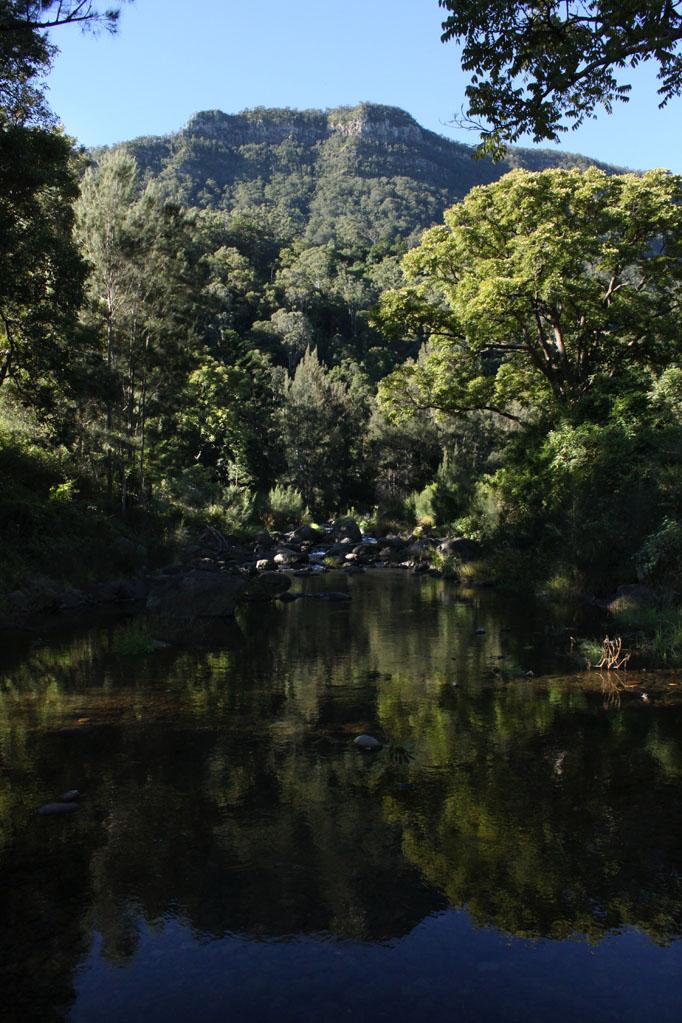
2 The Albert River - from Lamington National Park down to Moreton Bay The Lost World the Kerry Road Mt Widgee The right branch of the Albert River rises in Lamington National Park, and runs out of the park between the Lost World mountain and Mt Widgee. Sixteen kilometers after its beginning, the right branch, is joined by the left branch, which has begun on the eastern side of the Lost World Mountain. The Kerry Road runs from Beaudesert up to Darlington Park, a camping area next to the Albert River, and continues on to the Lost World. Bushwalkers leave from the roadhead to explore the river up to its rainforest origins.


3 Further downstream Cainbable Creek, then Canungra Creek joins the river which eventually flows through Beenleigh to join the Logan River about eleven kilometers upstream from Moreton Bay. While some very impressive floods come down the Albert, the canoeable sections of the river are those which are tidal, and just above the tidal reach. To explore the lower estuary section, the canoeist must launch from the boat ramp at the end of Alberton Road, onto the Logan River, and paddle 2.5 kilometres upstream to the junction of the Logan and Albert. Your street directory may seem to show other road access, but a drive down those side roads leads to either thick walls of mangrove trees between you and the river, or a steep drop from the bank, or thick black gooey mud. Rotary Park, 1.2 km upstream from Alberton Rd. ramp Alberton Road ramp, Riedel Road ramp across the river


4 Mt Stapylton and cane fields under the Pacific Highway bridges, Beenleigh From the Alberton Ramp it is 12 kilometres up to the Pacific Highway bridge. The countryside on the way is open cow pasture, or cane fields, as the tendency to flood keeps development out. The river makes its way around the overlooking Mt Stapylton, (no access), with its large golf ball radar dome on top. There isn t a boat ramp up under the Pacific Highway, but there is the possibility of getting off the river, if the tide is up. The small park under the bridge on the southern side looks best. It is at the end of the Old Pacific Highway, and if you haven t been that way for some years, you will rediscover the Yatala Pie Shop. Look at the old black and white prints on the shop walls to see the Albert River in flood. It is a total of 17 kms from Alberton ramp to Paterson Road ramp, and it is recommended that you avail yourself of a tidal push if going all the way. From the Paterson ramp it is a shorter 3 km to the Stanmore Road bridge, and a low level culvert crossing. This last section can be too shallow in places, at low tide, so mid tide on is recommended if launching or exiting there.. the Paterson Road ramp

, while a downstream launch may require")

5 downstream view, Paterson Road footbridge The old Stanmore Road bridge has a low level crossing that floods upstream at high tide, and an exposed rock garden at low tide. There is car parking across the river, turn off to the left just before the high level bridge, to cross the low level bridge. It is possible to launch at any stage of the tide if going upstream (other than times of little river flow), while a downstream launch may require some manouevering around the gravel bars. Somewhere between the Stanmore Road crossing and the Luscombe Weir, 4.5 kilometres upstream is the furtherest tidal reach. This upstream section is a very pleasant paddle, if you don t mind a trip up and back on the same water. The banks, for the most part, have thick tree cover, and it feels like a paddle through rainforest in some places. high tide Stanmore Road bridge low tide Stanmore Road bridge


6 Luscombe weir, Albert River The first rapid is encountered 2.0 kilometres upstream from Stanmore Road, and is a knee deep gravel race that can sometimes be paddled over. In May 2010 there was a fallen tree spanning the river a little further on upstream. Another 1.5 kilometres further on upstream the river goes under the Beaudesert Beenleigh Road bridge (where Vievers Road turns off). Under the bridge is a rocky bar, and the concrete remains of an old bridge that makes for a compulsory portage for the upstream paddler. 250 metres past the bridge is a series of rocky bars and rock gardens, making it the end of the trip for the upstream paddler. The rapids twist through a tangle of bottlebrush trees downstream from Luscombe weir. It is recommended that the section downstream from Luscombe Weir is paddled only by kayakers experienced on grade 2 white water, who have previously paddled upstream to explore the area. Fallen trees may block the river, and the land on both banks is jealously guarded private property. Note in photo, below, right, flood debris just under the bridge, and the broken concrete foundation just downstream from the bridge. tree across the river Beaudesert Beenleigh Road bridge


 on the Waterford Tambourine Road, near Clutha Creek offers improved access to the Albert River, but kayakers planning a trip should be prepared")
7 Untitled Document trees below Luscombe weir first rapid above Beaudesert Beenleigh Road bridge The section upstream from the weir, such as the 4 kilometre paddle from Chardon Road bridge down to the Luscombe Weir, is tree choked, and usually short of water. Further upstream sections suffer the usual problem of being too shallow in normal conditions, too tree choked and dangerous in higher water. There is obvious potential for kayaking further upstream, in that window of time that exists after rain has fallen in sufficient quantity to raise the level, but not so high as to be too dangerous. The new bridge being completed (May 2010) on the Waterford Tambourine Road, near Clutha Creek offers improved access to the Albert River, but kayakers planning a trip should be prepared to make several trips exploring. The upper Albert, near Kerry, likewise looks promising. In a river over 120 kilometres long, from rainforest headwaters to Moreton Bay estuary, there is a lot of potential for exploring. Charbon Road bridge, Albert River file:///e /aa%202010%20new%20stuff/aa%20albert/page007a.html (1 of 2)27/01/2012 7:30:21 PM
Highland Region MAP. No. 11 St. Marys River No. 12 West River No. 13 Wallace River No. 14 Toney River No. 15 Northumberland Strait
 Highland Region MAP No. 11 St. Marys River No. 12 West River No. 13 Wallace River No. 14 Toney River No. 15 Northumberland Strait 14 Route: No. 11 St. Marys River Rating: Intermediate Advanced Length:
Upstreampaddle 25.South arm of the Brunswick River, Simpson s Creek drains the freshwater swamp lands of Tyagarah Nature Reserve, 750 hectares. Furthe
 Upstreampaddle 24 The Brunswick River is a shorter length river on the coastal plain of Northern New South Wales. The areas of interest to canoeists are: the reach from the town of Mullumbimby down to
Pack Rafting The Wangapeka
 Pack Rafting The Wangapeka By Nathan Fa avae PAGE 28 Issue 88 Summer 2018 Pack-rafting is a paddle sport rapidly gaining popularity in New Zealand. I first discovered pack-rafts in 2002, at the Eco Challenge
Macutagon Creek to Russell s Landing
 Day Trips Macutagon Creek to Russell s Landing Manitouwadge Public Consultation Committee Canoe Route #13 #13 MACUTAGON CREEK TO RUSSELL S LANDING This route is suitable to all levels of paddlers but due
Canoe Trip # Maps: 63L Amisk Lake 63M Pelican Narrows
 Canoe Trip #51 49 Southeast Arem Deschambault Lake - Pelican Narrows - Wunehikun Bay - Attitti Lake - Belcher Lake - Mukoman Lake - Ohoo Lake - Mukoman River - Sokatisewin Lake - Sandy Bay 170 Kilometers
Canoe/Kayak Launch Sites and Accessibility
 Canoe/Kayak Launch Sites and Accessibility Doug Alderson, Paddling Trails Coordinator Division of Recreation and Parks Office of Greenways and Trails Each potential access site on a river, lake or ocean
Launch A: Experimental Lakes Road The launch site is about 4 km from highway #17. There is a sign on the highway indicating the experimental lakes
 Launch A: Experimental Lakes Road The launch site is about 4 km from highway #17. There is a sign on the highway indicating the experimental lakes road. You have to cross railway tracks on the way to the
Detailed maps, and portaging and camping information follow.
 Overview of Bain route. The launch site is at Davidson Lake, just before the Manitoba/Ontario border. You can do a loop if you leave a vehicle at Tulabi Lake (at the canoe route parking lot). The road
Environmental Definitions and Deployment Guidance for Instructors, Coaches and Leaders
 Environmental s and Deployment Guidance for Instructors, Coaches and Leaders This document provides guidance and environmental definitions that can be applied when choosing paddlesport activity. British
Canoe Trip # Length of Trip: 225 kilometres Time Required to Complete Trip: 10 to 14 days Number of Portages: 21 to 25
 Canoe Trip #34 34 Brabant Lake - Wapiskau River - Steephill Lake - Reindeer River - Churchill River - Sandy Bay 225 Kilometers - 10 to 14 days - 21 to 25 portages Length of Trip: 225 kilometres Time Required
HAWKESBURY-NEPEAN RIVER SYSTEM
 HAWKESBURY-NEPEAN RIVER SYSTEM Canoe & Kayak Trail Nepean River / Colo River / Hawkesbury River www.lpma.nsw.gov.au WELCOME Welcome to three canoeing and kayaking opportunities on the Hawkesbury-Nepean
Morgans Creek to Padstow
 Morgans Creek to Padstow 2 hrs 45 mins 8 km One way Moderate track 3 144m This pleasant walk starts from the Morgans Creek park, at Henry Lawsons Drive, and follows the Georges River past the Boomerang
OGILVIE AND PEEL RIVERS
 OGILVIE AND PEEL RIVERS Length of Trip 17 days from Ogilvie River bridge to Fort McPherson on the Peel River 22 days from Ogilvie River bridge to Inuvik Total Distance Start 516 kilometres (322.5 miles)
Start / Finish. Version 2
 Start / Finish Version 2 Gosford (Start) to Woy Woy Head South down Etna Street, crossing Henry Parry Drive, then Mann St, Gosford, where Etna St becomes Racecourse Road. Follow this road all the way
In 2015 we paddled from Blue Gums Caravan Park (near Eildon) to Seymour. In 2016 we paddled from Seymour to Shepparton.
 to Seymour. In 2016 we paddled from Seymour to Shepparton.") Goulburn River Shepparton to Moama, 19-24 th November 2017 This was the third leg of the journey down the Goulburn River. In 2015 we paddled from Blue Gums Caravan Park (near Eildon) to Seymour. In 2016
Goulburn River Shepparton to Moama, 19-24 th November 2017 This was the third leg of the journey down the Goulburn River. In 2015 we paddled from Blue Gums Caravan Park (near Eildon) to Seymour. In 2016
Nerang River - Hinze dam
 Nerang River - Hinze dam In early February 2012, while driving down the Numinbah Valley Road to Chillingham, I saw that the gate to the western boat ramp at Hinze Dam was open. When I returned that way
Middle Harbour Creek Loop
 Middle Harbour Creek Loop 5 hrs 45 mins 15.1 km Circuit Experienced only 5 570m This walk explores the upper reaches of Middle Harbour Creek, starting and ending at the great parklands at Davidson Park,
Canoe Route. Dogtooth Lake-Highwind Lake-Dryberry Lake- Lake of the Woods-Blindfold Lake
 1 Canoe Route Dogtooth Lake-Highwind Lake-Dryberry Lake- Lake of the Woods-Blindfold Lake This is an interesting and challenging route starting and ending at Rushing River Provincial Park. It passes over
International Learn To Swim Programme Water Safety Questions
 International Learn To Swim Programme Water Safety s s for First Step Series s Poolside Safety & Poolside Rules 1. Where is the shallow end of the The answer is specific to the centre. swimming 2. When
Marteg to Newbridge, October 2012 onwards.
 Marteg to Newbridge, October 2012 onwards. Map symbols: Reach Length: 12.4 miles Terms and Conditions: Canoeing can take place only when the water height is above 0.8m on the EAW gauge at Dhol Farm AND
SELF GUIDED TOURING ROUTE
 SELF GUIDED TOURING ROUTE Things to see and places to go on the loop from Orbost to Marlo, Cape Conran, Cabbage Tree and back to Orbost (or onwards to Cann River) V6 April 2017 This guide should be read
Both walks take you through stunning landscape and you are surrounded by the incredibly diverse flora and fauna of Lamington National Park.
 v Join the Stinson Walk Recount Australian history and celebrate the life of Bernard O Reilly, who heroically saved the lives of two plane crash survivors over 80 years ago in World Heritage-listed Lamington
CHAPTER X: PORTAGES AROUND DAMS
 CHAPTER X: PORTAGES AROUND DAMS A. General Description Portages are land routes used by paddlers to transport their boats to and from a launch area or between access sites. Often located along water bodies
By Gloria Hildebrandt Photographed by Mike Davis except where noted
 FOLLOWING THE FISH: Owen Sound s Salmon Run By Gloria Hildebrandt Photographed by Mike Davis except where noted SALMON LIVE IN THE GREAT LAKES and the rivers of the Niagara Escarpment that drain into the
Rappahannock River from Chester Gap to Chesapeake Bay
 Rappahannock River from Chester Gap to Chesapeake Bay Location: The Rappahannock River runs 186 miles from the Chester Gap (N38.92401 W78.09573) to Chesapeake Bay (N73.62028 W76.41750) Fredericksburg (N38.29860
Surfers Against Sewage Are Calling For A Review of the UK s Bathing Water Sample Sites.
 Surfers Against Sewage Are Calling For A Review of the UK s Bathing Water Sample Sites. Welsh Report Surfers Against Sewage (SAS) believe the weekly bathing water samples required by the EU Bathing Water
The Canoe Trip: Optional Portage Number 1 - Nut Portage: Optional Portage Number 2 - English Bay Portage:
 Canoe Trip #9 9 La Ronge - Iskwatikan Lake - Churchill River - Pelican Narrows - Mirond Lake - Sturgeon-Weir River - Maligne Lake (Kilometre 275 Hanson Lake Road) 245 to 270 Kilometers - 7 to 10 days -
River Dynamics - Rafting FOCUS. Read 10 point text from rear of the room. Bottom
 Dynamics - Rafting FOCUS Read 10 point text from rear of the room. Bottom 1 This section focuses on rivers; how they flow and on some basic maneuvers which you can execute on the river. Dynamics Rafting:
THE BECK STONE Backstone Beck on Ilkley Moor
 THE BECK STONE Backstone Beck on Ilkley Moor 1 Three different routes which take in the best of the lower slopes of Ilkley Moor, with bracken, heather, a tarn (a small mountain lake) and rushing streams.
Androscoggin River Trail Access Sites. Mahoosucs. 168 miles from its source at Lake Umbagog to Merrymeeting Bay
 Androscoggin River Trail Access Sites Mahoosucs 168 miles from its source at Lake Umbagog to Merrymeeting Bay Trail Under Construction More than 40 Public Access Sites Available Androscoggin River Watershed
THE RESOURCES AGENCY OF CALIFORNIA Department of Fish and Game STREAM SURVEY
 File form No.. Date: 4/1/73. NAME: Maacama Creek COUNTY: Sonoma. STREAM SECTION: FROM: Maacama Creek Ranch TO: Chalk Hill Rd. Bridge LENGTH: 1.5 mi.. Bridge OTHER NAMES: Weather - Clear & Sunny RIVER SYSTEM:
DESCRIPTION OF THE CHELAN RIVER
 DESCRIPTION OF THE CHELAN RIVER The following information contains excerpts from the Whitewater Boating Feasibility Study conducted on the Chelan River in July, 2000. The Chelan River begins below the
NATURAL RESOURCES WALES / RESCUE 3 EUROPE WEIR ASSESSMENT SYSTEM
 EUROPE NATURAL RESOURCES WALES / RESCUE 3 EUROPE WEIR ASSESSMENT SYSTEM Name of assessor: Date of assessment: WEIR INFORMATION Name of weir / site: Other names weir known as: Weir location and river: Grid
Androscoggin River Trail Access Sites. Mahoosucs. 168 miles from its source at Lake Umbagog to Merrymeeting Bay
 Androscoggin River Trail Access Sites Mahoosucs 168 miles from its source at Lake Umbagog to Merrymeeting Bay Trail Under Construction More than 40 Public Access Sites Available Androscoggin River Watershed
Epping to Pennant Hills Station (via Lane Cove River)
") Epping to Pennant Hills Station (via Lane Cove River) 3 hrs 5 mins 8.4 km One way Hard track 249m This walk, from Epping to Pennant Hills Station, is a great way to see the upper Lane Cove River Valley.
Epping to Pennant Hills Station (via Lane Cove River) 3 hrs 5 mins 8.4 km One way Hard track 249m This walk, from Epping to Pennant Hills Station, is a great way to see the upper Lane Cove River Valley.
Lower Mississippi River Dispatch No. 338 March 18, 2016 Sunflower River Flood Clarksdale Flooded -- Including Quapaw Canoe Company
 Lower Mississippi River Dispatch No. 338 March 18, 2016 Sunflower River Flood Clarksdale Flooded -- Including Quapaw Canoe Company Our beloved Cave as the water was rising... it eventually crested at chest
Waterfall to Heathcote
 Waterfall to Heathcote 5 hrs Hard track 10.8 km One way 4 467m This walk explores the heart of Heathcote National Park, and is easily accessed with a train station at either end. Although relatively close
Epping to Eastwood Station (via Lane Cove River)
") Epping to Eastwood Station (via Lane Cove River) hrs 45 mins 10.2 km One way Moderate track 189m Epping to Eastwood, via Lane Cove River, is the longer route through the bush between the stations. This
Epping to Eastwood Station (via Lane Cove River) hrs 45 mins 10.2 km One way Moderate track 189m Epping to Eastwood, via Lane Cove River, is the longer route through the bush between the stations. This
Cross Country Skiing in the Tumbler Ridge Area
 Cross Country Skiing in the Tumbler Ridge Area There are numerous locations that are great for cross country skiing in the area surrounding Tumbler Ridge. Some are on trails that have hiking brochures
Tahquamenon River Assessment
 State owned land USFS land Superior Lower Falls USGS Gauging Station Superior Tahquamenon s Belle s Slater s Bass Betty B Dollarville Flooding Eckerman McMillan Mud East Kaks Twin McPhee s Hulbert Hulbert
2012 Susitna River Water Temperature and Meteorological Field Study
 (FERC No. 14241) 2012 Susitna River Water Temperature and Meteorological Field Study Appendix A Prepared for Prepared by URS Corporation Tetra Tech Inc. February 2013 APPENDIX A: PHOTOGRAPHS AND SITE INFORMATION
Cymyran Strait and Rhoscolyn
 Borthwen and Rhoscolyn Beacon - Photo: www.pixaerial.com 7 No. 7 Grade B 18km OS Sheet 114 Tidal Port Liverpool Start Four Mile Bridge (280783) Finish Porth Dafarch (233800) HW/LW are around 1 hour 30
Hunters Hill to Epping Road
 Hunters Hill to Epping Road 2 hrs 30 mins 5.5 km One way Moderate track 154m An enjoyable walk through lower sections of the Lane Cove National Park, this walk features plenty of mangroves next to the
Kayak Trip Yeppoon to Stanage Bay (Central Qld coast)
") Kayak Trip Yeppoon to Stanage Bay (Central Qld coast) August 2018. Robin Aurisch. This trip was inspired by a report on the Upstream Paddle site where 5 paddlers did a similar trip back in 2009. To make
Kayak Trip Yeppoon to Stanage Bay (Central Qld coast) August 2018. Robin Aurisch. This trip was inspired by a report on the Upstream Paddle site where 5 paddlers did a similar trip back in 2009. To make
Berowra to Mt Kuring-gai
 Berowra to Mt Kuring-gai 4 hrs 30 mins 9.4 km One way Hard track 4 551m From the ridges above Cowan Creek, this walk takes in some great lookouts (especially around Mt Kuringgai) as well as enjoying an
8 Miles Circular 4 hours
 VISIT RYEDALE HELMSLEY AND RICCAL DALE 8 Miles Circular 4 hours 090616 Challenging Terrain An 8 mile (13km) circular walk from the market town of Helmsley in Ryedale. The route heads out across sheep pastures
In order to have an enjoyable day out canoeing we need to make some key decisions to ensure we are in the right place at the right time.
 Award Description This award is designed to progress your judgment, decision making and expertise providing an understanding of journeying. As a canoeist you should be confident in planning and undertaking
Walk WOC 02 Location: Usk Reservoir
 5 Walk WOC 02 Location: Usk Reservoir Directions: Right out of castle, first left opposite Tafan y Garreg pub, over the mountain on single track roads for about 8 miles. At first T junction you come to,
3 STAR TRIPS & ACTIVITIES
 Lower Tryweryn Weekend trip This is a classic grade 2 section of river from the National Whitewater Centre in Frongoc down to Bala. There is one grade 3 section at the very start and a grade 4 drop at
Trail Notes Local Mountain Bike Areas
 Trail Notes Local Mountain Bike Areas Campus Recreation 875 Perimeter Drive MS 1230 Moscow. Idaho 83844-1230 Ph: 208.885.6810 Rentals: 208.885.6170 Fax: 208.885.6879 uidaho.edu/outdoorprogram 1 Table of
The Great Kayak Expedition
 Ethan went on a kayaking expedition down the Ottauquechee River last week. He left school at 2:35 and paddled downstream 3 miles until he hit the sewage treatment plant at 3:05. He decided to get out of
62. Gulkana River, Main Fork, Middle Fork, and West Fork
 62. Gulkana River, Main Fork, Middle Fork, and West Fork The Gulkana, a National Wild and Scenic River, is one of Alaska s most popular whitewater rivers because of its road accessibility and because of
Cedar River Paddling Trips Otranto, through Charles City, to Janesville Canoes, Kayaks, and SUPs Charles City Chamber of Commerce.
 Cedar River Paddling Trips Otranto, through Charles City, to Janesville Canoes, Kayaks, and SUPs Charles City Chamber of Commerce Paddle the Cedar In addition to the whitewater course in Charles City,
RIVERS KIDS HOPE AUS. THEMED MENTOR HOUR. Background: Interesting River Facts
 KIDS HOPE AUS. THEMED MENTOR HOUR RIVERS Background: Interesting River Facts The longest river in the world is the Nile River, it reaches around 6650 kilometers in length (4132 miles). More Nile River
Entry form available at:
 This document provides the event information as it becomes available. Document status: Date Changes Who 15 th May 2015 Original draft Nick Adnitt 22 nd May 2015 Course map, start/finish, portage diagrams
Peaceful Creeks. by James
 Peaceful Creeks by James I grew up in the Pilbara. More specifically, I spent about 18 years in the town of Port Hedland. I believe it was a good place to live. I am 29 years old and I still have friends
Examples of estuaries include bays, sounds, salt marshes, mangrove forests, mud flats, swamps, inlets, and sloughs.
 An estuary is a partially enclosed body of water where incoming seawater is mixed with fresh water coming from the land. Examples of estuaries include bays, sounds, salt marshes, mangrove forests, mud
2018 Kathmandu Coast to Coast - Race Safety Briefing (Compulsory Section to attend)
") 2018 Kathmandu Coast to Coast - Race Safety Briefing (Compulsory Section to attend) These notes are current at time of email additional safety messages will be given at the pre-race safety briefings at
2018 Kathmandu Coast to Coast - Race Safety Briefing (Compulsory Section to attend) These notes are current at time of email additional safety messages will be given at the pre-race safety briefings at
Carrington Park to Leura Forest and pass loop
 Carrington Park to Leura Forest and pass loop 3 hrs Hard track 4.8 km Circuit 4 674m This walk is a fantastic way to see Leura Forest. The walk descends from Carrington Park, visiting Leura Forest and
RIVER TYNE ROWING CLUBS SAFETY CODE
 RIVER TYNE ROWING CLUBS SAFETY CODE Revised 11 June 2010 This safety code is specific to the River Tyne between Redheugh Bridge and Wylam and should be read and operated in conjunction with: British Rowing
VERN S CAMP from Minginui
 VERN S CAMP from Minginui Map: Kuratau, 1:50,000 V18 Refer Figures 1, 3, 4 and 5 GPS: Geodetic Datum 1949 Refer Figure 10a (Geographic) and 10b (NZ Grid) How to get to START: From the police station on
Dorridge & District Residents Association A Walk Along The Green Belt From Dorridge to Catherine-de-Barnes
 Dorridge & District Residents Association A Walk Along The Green Belt From Dorridge to Carine-de-Barnes The starting section of this walk through open fields would be destroyed by building of motorway
There are toilets at Manningtree Station, Flatford (close to the hump back bridge) and in Dedham.
 and in Dedham.") Arriving by Train Main Features of the Walk Outline Route Employs particularly attractive paths, many of which offer impressive views across Dedham Vale. Includes a section along the tidal section of the
Arriving by Train Main Features of the Walk Outline Route Employs particularly attractive paths, many of which offer impressive views across Dedham Vale. Includes a section along the tidal section of the
Currie Rd to Davidson Park
 Currie Rd to Davidson Park 3 hrs 7.2 km One way Moderate track 28m Starting at Currie Rd in Forestville, this walk follows Middle Harbour to Davidson Park, under Roseville Bridge. There are two optional
Mangrove Kayaking Tours in Abu Dhabi
 Mangrove Kayaking Tours in Abu Dhabi Experience a unique marine eco-system with spectacular mangrove scenery on a short, guided kayaking adventure in Abu Dhabi. Our experienced and knowledgeable team will
SUMMER WALK 10. The Chairmakers, Worlds End
 SUMMER WALK 10 The Chairmakers, Worlds End Tuesday 10 th June 7.30pm This is a very short walk made so due to the majority of the footpaths in the area around the Chairmakers being overrun with high nettles
Sidewalk Accessibility Checklist
 Starting Address: Ending Address: Date: Sidewalk Accessibility Checklist Please indicate your experience with any barriers you encountered when using the sidewalks in your neighborhood. 1. Did you have
WHAT IS A TSUNAMI? happens.nz. Long or Strong GET GONE TSUNAMI 101
 WHAT IS A TSUNAMI? A tsunami is a series of powerful waves with strong currents. They are mostly caused by underwater or coastal earthquakes, and sometimes by underwater landslides or volcanic eruptions.
Running Southwest Florida Beaches. By Eddie Underhill
 Running Southwest Florida Beaches By Eddie Underhill Intro: 1. For years I have been running Fort Myers Beach. I live at Fairview Isles, so I start at the beach here in front of the Gullwing Hotel and
The speed of an inline skater is usually described in meters per second. The speed of a car is usually described in kilometers per hour.
 The speed of an inline skater is usually described in meters per second. The speed of a car is usually described in kilometers per hour. Speed How are instantaneous speed and average speed different? Average
Rock Climbing in Kowloon, Qing Yuan County, Guangdong, PRC
 Rock Climbing in Kowloon, Qing Yuan County, Guangdong, PRC The following notes, maps and topos form a rough guide to most of the established climbing in the Kowloon (Nine Dragons) area of Qing Yuan County,
4 Star Touring Leader Assessment Notes
 4 Star Touring Leader Assessment Notes Technical Syllabus Please note - the provider should use their discretion on elements of the syllabi when due to the craft being paddled, the syllabi request something
Sphinx to Mt Kuring-gai
 Sphinx to Mt Kuring-gai 4 hrs 45 mins 1.7 km One way Hard track 673m This walk starts at the Sphinx War Memorial and follows some well maintained and popular walking tracks down to Cowan Creek. Enjoy the
North of Magical. Remote Arctic Wilderness, Northern Lights and. a Canadian Tundra Adventure Race
 North of Magical Remote Arctic Wilderness, Northern Lights and a Canadian Tundra Adventure Race The Canadian Arctic Late August is the perfect time for this extreme adventure at our remote fly-in Lodge
STREAM SURVEY File form No..
 scanned for KRIS THE RESOURCES AGENCY OF CALIFORNIA California Department of Fish and Game STREAM SURVEY File form No.. Date: September 4, 1969. NAME: North Fork Schooner Gulch Creek COUNTY: Mendocino.
Unravelling Rivers. This pack consists of activity sheets for individual and group work, and whiteboard pictures for class discussion.
 Unravelling Rivers This pack consists of activity sheets for individual and group work, and whiteboard pictures for class discussion. Teacher guidance notes can be downloaded here. What do you know about
De Burgs Bridge to Thornleigh station
 De Burgs Bridge to Thornleigh station 3 hrs 45 mins 9.7 km One way Hard track 4 363m This walk follows a section of the Great North Walk, starting from De Burghs bridge. The walk winds north west, through
Harvey Dam. Dam Wall P CP. Lookout. Spillway. Intake Tower. Harvey River. Viewing Area. Key Buildings Stage Amphitheatre Gazebo
 Harvey Dam Access Rd N Lookout Spillway Intake Tower Harvey Quindanning Road Harvey River C Dam Wall Viewing Area Harvey Dam 0 200 m Key Buildings Stage Amphitheatre Gazebo C Gas Barbecue layground arking
Claytor Lake View of the Claytor Lake dam from Claytor Lake State Park s boat ramp.
 Claytor Lake 2007 Imagine yourself on a waterbody that is more like a wide river than a lake. When you do, you will have a picture of Claytor Lake. Claytor Lake, a 4,475-acre reservoir, stretches northeastward
River. Dynamics Canoeing: This section focuses on rivers; how they flow and on some basic maneuvers which you can execute on the river.
 This section focuses on rivers; how they flow and on some basic maneuvers which you can execute on the river. Dynamics Canoeing: By Robert B. Kauffman, Ph.D. 1 Topics - Laminar and shore to center flows
Urban whitewater: If you avoid disaster,
 Urban whitewater: If you avoid disaster, With a little practice a beginner can make this fun float trip from west Reno to the Sparks whitewater park in a few hours. Benjamin Spillman/RGJ Benjamin Spillman,
INFORMATION PACK AND REGISTRATION FORM
 THE ROTARY CLUB OF TOTNES TOTNES RAFT RACE Sunday 30 th September 2018 IN ASSOCIATION WITH TOTNES CANOE CLUB TOTNES SUB-AQUA CLUB ST JOHN AMBULANCE TOTNES SEA SCOUTS RAYNET INFORMATION PACK AND REGISTRATION
*Sandy Point State Park Paddling Routes
 *Sandy Point State Park Paddling Routes *Paddleboards are crazy popular in Anne Arundel County creeks and rivers. The life guards on this park s beaches have paddleboards to use in recusing swimmers. Not
Chinook Salmon Spawning Study Russian River Fall 2005
 Chinook Salmon Spawning Study Russian River Fall 2005 Sonoma County Water Agency 2150 West College Avenue Santa Rosa, California 95401 Prepared by David Cook - Senior Environmental Specialist March 27,
Thames Passage From Brentford to Teddington
 Thames Passage From Brentford to Teddington Introduction: The Thames Ring route uses a tidal section of the river Thames between Brentford and Teddington that requires extra preparation and skill. We hope
Study Tour A: Lesotho (Pre-tour) 11 to 15 May 2016
 11 to 15 May 2016") Study Tour A: Lesotho (Pre-tour) 11 to 15 May 2016 Introduction This five day tour will take you through the Kingdom of Lesotho, home to the Lesotho Highlands Water Project. We will visit the impressive
Study Tour A: Lesotho (Pre-tour) 11 to 15 May 2016 Introduction This five day tour will take you through the Kingdom of Lesotho, home to the Lesotho Highlands Water Project. We will visit the impressive
Axe Vale Canoe Club (AVCC) Risk Register GENERIC RISK ASSESSMENT
 Risk Register GENERIC RISK ASSESSMENT") GENERIC RISK ASSESSMENT Slips, Trips and Falls Drowning Leader to inspect area of operation. under 18 year olds will wear a safety helmet when on the water. Shoes to be worn at all times outside changing
GENERIC RISK ASSESSMENT Slips, Trips and Falls Drowning Leader to inspect area of operation. under 18 year olds will wear a safety helmet when on the water. Shoes to be worn at all times outside changing
* Making Rivers & Water Falls *
 www.krafttrains.com * Making Rivers & Water Falls * Several different methods are used to make this focal point of the layout. All the techniques are explained along with helpful hints and tips. Click
For more information and to buy this book click here ISBN: CICERONE. Guides for walkers, trekkers, mountaineers, climbers and cyclists
 For more information and to buy this book click here ISBN: 9781852845377 CICERONE Guides for walkers, trekkers, mountaineers, climbers and cyclists www.cicerone.co.uk WALK 5 Ouston and Urpeth Distance
Katoomba Falls Circuit
 Katoomba Falls Circuit hr 5 mins.5 km Circuit Hard track 59m For those looking for a walk involving more than simple boardwalk, this trail winding through the temperate rain forest could be just the thing.
Falls Lake Trail (A part of the NC Mountains-to-Sea Trail) East to West
 East to West") Falls Lake Trail (A part of the NC Mountains-to-Sea Trail) East to West Section 1 (Falls of the Neuse Rd to Raven Ridge Rd) 0.0 mi Parking area of the Tailrace Fishing Area, just below the dam, off Falls
Falls Lake Trail (A part of the NC Mountains-to-Sea Trail) East to West Section 1 (Falls of the Neuse Rd to Raven Ridge Rd) 0.0 mi Parking area of the Tailrace Fishing Area, just below the dam, off Falls
TECHNICAL MEMORANDUM 002 EMORANNO. 001
 TECHNICAL MEMORANDUM 002 EMORANNO. 001 To: Jack Synder, P.E. EES Consulting From: Mort McMillen, P.E. Paul Larson, SE Date: October 13, 2010 Project: Cc: Taylor Bowen Subject: Technical Memorandum (TM)
ROUTE 2. Bateau Channel. Topographic Map 31 C/8 Navigation Charts 1438/39 Reference Maps
 Topographic Map 31 C/8 Navigation Charts 1438/39 Reference Maps ROUTE 2 Bateau Channel The shoreline marshes of the Bateaux Channel team with life. Wetlands provide breeding habitat for amphibians, fish
NATIONAL MARATHON CHAMPIONSHIPS 2010 INFORMATION AND ENTRY PACK. DATES: Saturday 31st July and Sunday 1st August 2010
 NATIONAL MARATHON CHAMPIONSHIPS 2010 INFORMATION AND ENTRY PACK DATES: Saturday 31st July and Sunday 1st August 2010 HOSTS: WEBSITE: VENUE: Chester Sailing and Canoeing Club www.chestercanoenationals.org.uk
lot across from the Barrington Post Office, please do not use Woolen Mill Museum parking if there are more than 1 vehicle.
 BARRINGTON Launch Rating Moderate to difficult depending on your skills. Launch Description This launch is usable at high tide using proper skills to enter and exit your kayak. Put in just above the concrete
PADDLING THE LOWER STILLAGUAMISH RIVER by Paddle Heaven
 PADDLING THE LOWER STILLAGUAMISH RIVER by Paddle Heaven PUBLISHED BY: Paddle Heaven on Smashwords Paddling the Lower Stillaguamish River Copyright 2010 by Paddle Heaven All rights reserved. Without limiting
APPENDIX C BLUEWAYS ASSESSMENT
 APPENDIX C Blueways Assessment Poor Fork of Cumberland River Section above Kingdom Come State Park and Cumberland, KY By Steve Spencer, Ed.D. Western Kentucky University The author is an American Canoe
In the case of capsize, staff to ensure all participants involved are accounted for and safe. ANY NON-PADDLERS MUST STAY AWAY Low High
 RISK ASSESSMENT FOR: Canoeing and Kayaking Reviewed Feb 2018 Written by: Kevin Beattie (Paddlesport Tech Advisor) HAZARD Severity Likelihood LIST OF CONTROL MEASURES OVERALL RESIDUAL RISK RATING (/Med/High)
Newsletter. Committee. Saturday 8am. Sunday 4pm. Tuesday 5pm. Thursday 5pm LISMORE BOATSHED. November 2012 PADDLING TIMES AT. The debrief!
 FAR NORTH COAST CANOE CLUB PO BOX 469, LISMORE NSW 2480 HTTP://WWW.FNCCC.CANOE.ORG.AU/ November 2012 Editor: Cathy Donnelly email: cmdonnelly@bigpond.com The Newsletter Inside this issue: Committee President
The Jenkinsburg River Access Project
 Left: Keith Pitzer, executive director, Friends of Cheat; Right: Dave Hough, Managing Partner of Mountain Streams A view of the takeout from the Jenkinsburg Bridge; the Big Sandy Creek comes in on the