TOURISTICS + Shoreplan Engineering Limited
|
|
|
- Eleanor Jones
- 6 years ago
- Views:
Transcription

1 TOURISTICS + Shoreplan Engineering Limited i
2 TABLE OF CONTENTS LIST OF TABLES... iii LIST OF FIGURES... iii LIST OF EXHIBITS... iii EXECUTIVE SUMMARY... vii SECTION 1 - INTRODUCTION Background Study Approach Report Format... 2 SECTION 2 EXISTING RECREATIONAL BOATING FACILITIES IN HALTON REGION Boating Facilities Amenities and Services Seasonal and Transient Slip Users Assessment of Infrastructural Features at Boating Facilities La Salle Park Bronte Harbour Oakville Harbour Oakville Harbour Marina - Oakville Harbour Oakville Yacht Squadron The Oakville Club Wai Nui O Kanaka Outrigger Canoe Club Oakville Power Boat Club Burloak Canoe Club Other Boating Facilities in Halton Comparison of Halton s Boating Facilities with those of the GTA/Golden Horseshoe Area Boating Facilities Amenities and Services Seasonal and Transient Slip Users Facilities in Halton Compared with the GTA/Golden Horseshoe Area Marina Rates and Fees in Halton Compared with the GTA/Golden Horseshoe Area Annual Rate Increases TOURISTICS + Shoreplan Engineering Limited i
3 SECTION 3 PROFILE OF BOATERS AND POPULATION CHARACTERISTICS Introduction Socio-demographic Profile of Sail and Power Boaters Socio-demographic Characteristics of Burlington, Oakville and Halton Residents Projected Population of Halton 2013 to Projected Growth in Boating Activities SECTION 4 EXISTING AND PROJECTED NUMBER OF BOATS IN ONTARIO Introduction Historical Number of Boats by Length, Beam and Draft, 2007 to Length Beam Draft Projected Number of Boats Length of Ontario Boats Beam of Ontario Boats Draft of Ontario Boats Length of New York State Boats Beam of New York State Boats Draft of New York State Boats SECTION 5 CURRENT AND PROJECTED NEED FOR SEASONAL AND TRANSIENT SLIPS AND LAUNCH RAMPS IN HALTON REGION Introduction Need for Seasonal Slips Need for Transient Slips Transient Boater Market Existing Number of Transient Boats in Market Area Projected Number of Transient Boats in Market Area What Transient Boaters are Interested In Need for Launch Ramps SECTION 6 PLANNING FOR FUTURE BOATER NEEDS IN HALTON Introduction Monitoring Current Demand Situation Meeting Future Seasonal Slips and Boater Demand TOURISTICS + Shoreplan Engineering Limited ii
4 LIST OF TABLES Table 1 Boating Facilities in Halton... 3 Table 2 Boating Facilities in Halton Compared to the GTA/Golden Horseshoe Area Table 3 Evaluation of Halton s Harbours Boating Facilities Table 4 Strengths, Weaknesses, Opportunities and Threats for Recreational Boating in Halton LIST OF FIGURES Figure 1 La Salle Park... 4 Figure 2 Oakville Harbour... 5 Figure 3 Bronte Harbour... 6 Figure 4 Launch Ramp Locations... 7 Figure 5 Residence of Boat Owners at Seasonal Slips... 9 Figure 6 Boating Participation in Ontario Figure 7 Halton Population Projections 2011 to 2031 (25 and over) Figure 8 Projected Growth in Halton s Share of Ontario s Power and Sail Boaters Figure 9 Projected Growth in Percentage of Ontario s Population Participating in Selected Boating Activities Figure 10 Projected Growth in Number of Power and Sail Boaters in Halton (2013 to 2031) Figure 11 Historical Growth of Ontario s and New York s Recreational Boats 6 metres to less than 8 metres (2007 to 2012) Figure 12 Historical Growth in Length of Largest Ontario s Recreational Boats (2007 to 2012) Figure 13 Historical Growth in Length of Largest New York State s Recreational Boats (2007 to 2012) Figure 14 Percentage Share of Ontario s Boat Market by Length of Boat (2007 to 2031) LIST OF EXHIBITS EXHIBIT 1A MARINAS, YACHT AND BOAT CLUBS WITHIN HALTON REGION NUMBER AND SIZE OF SLIPS EXHIBIT 1B MARINAS, YACHT AND BOAT CLUBS WITHIN HALTON REGION FACILITIES AND SERVICES EXHIBIT 1C MARINAS, YACHT AND BOAT CLUBS WITHIN HALTON REGION FEES AND USER PATTERNS EXHIBIT 1D MARINAS, YACHT AND BOAT CLUBS WITHIN HALTON REGION ASSESSMENT OF DOCKS, FAIRWAYS, BREAKWATER AND FUEL DOCKS EXHIBIT 1E MARINAS, YACHT AND BOAT CLUBS WITHIN HALTON REGION ASSESSMENT OF PUMPOUT STATIONS, LAUNCH RAMPS AND SECURITY MEASURES EXHIBIT 2A PROGRAMS OFFERED BY BOATING CLUBS WITHIN HALTON REGION TOURISTICS + Shoreplan Engineering Limited iii
5 EXHIBIT 2B PROGRAMS OFFERED BY YACHT AND SAILING CLUBS WITHIN HALTON REGION EXHIBIT 3 KELSO CONSERVATIN BOAT RENTALS EXHIBIT 4A MARINAS AND YACHT CLUBS WITHIN THE GREATER TORONTO AREA (GTA)/GOLDEN HORSESHOE NUMBER AND SIZE OF SLIPS EXHIBIT 4B MARINAS AND YACHT CLUBS WITHIN THE GREATER TORONTO AREA (GTA)/GOLDEN HORSESHOE FACILITIES AND SERVICES EXHIBIT 4C MARINAS AND YACHT CLUBS WITHIN THE GREATER TORONTO AREA (GTA)/GOLDEN HORSESHOE FEES EXHIBIT 5 COMPARISON OF 2014 SUMMER AND WINTER MARINA FEES IN HALTON REGION AND THE GTA/GOLDEN HORSESHOE AREA EXHIBIT 6 ANNUAL SUMMER AND WINTER RATES AND FEES 2014 (30 foot boat) EXHIBIT 7 MARINA FACILITIES AND SERVICES RATING EXHIBIT 8 EVALUATION OF MARINA SERVICES AND FACILITIES IN HALTON REGION AND GTA/GOLDEN HORSESHOE AREA EXHIBIT 9 SELECTED SOCIO-DEMOGRAPHIC CHARACTERISTICS OF RESIDENTS WITHIN HALTON REGION EXHIBIT 10 POPULATION PROJECTIONS FOR HALTON REGION BY AGE AND GENDER CATEGORIES IMPORTANT TO RECREATIONAL BOATING EXHIBIT 11 POPULATION PROJECTIONS FOR ONTARIO BY AGE AND GENDER CATEGORIES IMPORTANT TO RECREATIONAL BOATING EXHIBIT 12 LENGTH OF BOATS REGISTERED WITHIN ONTARIO AND NEARBY U.S. STATES.. 94 EXHIBIT 13 BEAM OF BOATS REGISTERED WITHIN ONTARIO AND NEARBY U.S. STATES EXHIBIT 14 DRAFT OF BOATS REGISTERED WITHIN ONTARIO AND NEARBY U.S. STATES EXHIBIT 15 TYPE OF BOAT REGISTERED IN ONTARIO AND NEARBY U.S. STATES EXHIBIT 16 NUMBER OF BOATS IN OTHER CANADIAN PROVINCES AND TOP 12 U.S. STATES IN EXHIBIT 17 PLEASURE CRAFT LICENSES GRANTED BY TRANSPORT CANADA IN EXHIBIT 18 PLEASURE CRAFT LICENSES CANCELLED BY TRANSPORT CANADA IN EXHIBIT 19 PROJECTED GROWTH BY LENGTH OF BOATS REGISTERED IN ONTARIO (2013 to 2031) EXHIBIT 20 PROJECTED GROWTH BY BEAM (WIDTH) OF BOATS REGISTERED IN ONTARIO (2013 to 2031) EXHIBIT 21 PROJECTED GROWTH BY DRAFT OF BOATS REGISTERED IN ONTARIO (2013 to 2031) EXHIBIT 22 PROJECTED GROWTH BY TYPE OF BOATS REGISTERED IN ONTARIO (2013 to 2031) EXHIBIT 23 PROJECTED GROWTH BY LENGTH OF BOATS REGISTERED IN NEW YORK STATE (2013 to 2031) TOURISTICS + Shoreplan Engineering Limited iv
6 EXHIBIT 24 PROJECTED GROWTH BY WIDTH OF BOATS REGISTERED IN NEW YORK STATE (2013 to 2031) EXHIBIT 25 PROJECTED GROWTH BY DRAFT OF BOATS REGISTERED IN NEW YORK STATE (2013 to 2031) EXHIBIT 26 PROJECTED GROWTH BY TYPE OF BOATS REGISTERED IN NEW YORK STATE (2013 to 2031) EXHIBIT 27 ESTIMATED NUMBER OF SEASONAL BOATS WITHIN HALTON REGION EXHIBIT 28 DEMAND FOR SEASONAL SLIPS WITHIN HALTON REGION EXHIBIT 29 AVERAGE DISTANCE TRAVELLED AWAY FROM MARINA EXHIBIT 30 AVERAGE NUMBER OF DAYS USING A BOAT EXHIBIT 31A MARINAS WITHIN 20 NAUTICAL MILES OF BRONTE HARBOUR EXHIBIT 31B MARINAS WITHIN 21 TO 40 NAUTICAL MILES OF BRONTE HARBOUR EXHIBIT 31C MARINAS WITHIN 41 TO 60 NAUTICAL MILES OF BRONTE HARBOUR EXHIBIT 31D MARINAS WITHIN 61 TO 80 NAUTICAL MILES OF BRONTE HARBOUR EXHIBIT 32 NUMBER OF SEASONAL AND TRANSIENT SLIPS WITHIN TRANSIENT MARKET AREA OF HALTON REGION BOATING FACILITIES EXHIBIT 33 NUMBER OF POWER AND SAIL BOATS WITHIN TRANSIENT MARKET AREA OF HALTON REGION BOATING FACILITIES EXHIBIT 34 POTENTIAL TRANSIENT BOATS WITHIN MARKET AREA OF HALTON REGION BOATING FACILITIES IN EXHIBIT 35 PROJECTED NUMBER OF BOATS WITHIN 80 NAUTICAL MILES OF HALTON REGION BOATING FACILITIES 2013 TO EXHIBIT 36 PROJECTED NUMBER OF TRANSIENT BOATERS WITHIN 80 NAUTICAL MILES OF HALTON REGION BOATING FACILITIES 2013 TO EXHIBIT 37 ESTIMATED NUMBER OF BOATS IN HALTON REGION LIKELY TO USE A LAUNCH RAMP FOR THEIR BOATING ACTIVITY TOURISTICS + Shoreplan Engineering Limited v
7 TOURISTICS + Shoreplan Engineering Limited vi
8 EXECUTIVE SUMMARY Study Objectives TOURISTICS and Shoreplan Engineering Limited were retained by the Town of Oakville, City of Burlington (in partnership with LaSalle Park Marina Association) and Halton Region to conduct the first of a two phased study to determine the current and anticipated demand for recreational boating facilities within Halton and the Greater Toronto Area (GTA)/Golden Horseshoe Region over the period from 2013 until 2031 and the need to accommodate any future demand for additional slips. The intent of the study was to provide a comprehensive analysis of current harbour capacity within the GTA/Golden Horseshoe region and specifically within Halton Region. It was also the intent of the study to assess the changing demographic profile or the area and the impacts of these changes on the anticipated demand for recreational boating, the sources and location of this demand, trends in the type of boating and berth requirements with the aim of making recommendations on whether or not additional harbour capacity is warranted within Halton. The demand for additional slips and launch ramps in Halton will be dependent on three major factors: The ability of the existing marina facilities within the market area to meet the current and future demand, and the overall occupancy rate of the marinas within the seasonal market area; The growth in the number of power and sail boats in the seasonal market area and the changes in their length, beam and draft; and, The market area for seasonal slips and launch ramps exhibiting socio-demographic characteristics that are strong determinants of power and sail boating demand. Key Findings Boating Facilities in Halton There are four marinas, three yacht clubs, one power boat club, and four boating clubs in Halton Region. They provide recreational boating enthusiasts with opportunities for canoeing, kayaking, sailing, and the use of catamarans, outrigger canoes, and stand up paddle boards. In addition, the reservoir at Kelso Conservation Area, lake at Mountsberg Conservation Area and Fairy Lake at Prospect Park all in the northern part of Halton provide areas suitable to launch and use small aluminum boats, canoes, kayaks, paddle boats and stand up paddle boards. In addition to the marinas, yacht and power boat clubs, Halton is also home to four boating clubs (Burloak Canoe Club, Burlington Sailing and Boating Club, Burlington Beach Catamaran Club, Wai Nui O Kanata Outrigger Canoe Club) catering to non-motorized boating activities. The four clubs offer opportunities for participation with canoes, outrigger canoes, kayaks, war canoes, dragon boats, dinghies, keel boats, paddle boats and stand up paddle boards. All report an increase in the number members, programs offered and participants in The programs are offered to members and non-members and both children and adults. The physical conditions of the boating infrastructure at the three existing harbour locations on Lake Ontario (Oakville Creek, Bronte Creek and LaSalle Park), are, with one exception, generally adequate with some poor conditions mostly related to dock spacing. The dock spacing tends to be less than suggested in current marina guidelines for public facilities and the docks are less stable than some currently available products for commercial facilities. Much of the docking is provided without finger docks. Most locations do not offer water and power on dock, as is commonly done. The one exception is Bronte Outer Harbour where the docks and their layout meet current guidelines and supporting infrastructure appears to be very in good condition. TOURISTICS + Shoreplan Engineering Limited vii
9 It is acknowledged that the Oakville is improving harbour infrastructure on ongoing basis, particularly as it relates to shoreline improvements. Further improvements are being planned. Burlington and LaSalle Park Marina Association recently completed a class environmental assessment for major wave protection improvements at La Salle Park Marina. Boating Facilities in Halton Compared with the GTA/Golden Horseshoe Area There are 41 boating facilities in the GTA/Golden Horseshoe Area between Scarborough in the east and St. Catharines in the west. Fourteen are marinas and the remaining 27 are yacht and sailing clubs. As shown in the Table following, although the occupancy rates and percentage of slips by length are similar, boaters at marinas and yacht clubs in Halton appear to be less well served than those in GTA/Golden Horseshoe area. As a percentage of total slips available, the GTA/Golden Horseshoe area offers twice as many transient slips as Halton and as a percentage of facilities, twice as many fuel docks. Although a higher percentage of facilities in the GTA/Golden Horseshoe area offer a pump out service, the number of slips per pump out is similar (i.e. 292 versus 336 in Halton). Both areas have insufficient on-site capacity to accommodate all the seasonal boats for winter storage (i.e. 71% in Halton versus 87% in the GTA). The demand for additional slips is much higher in Halton than the GTA/Golden Horseshoe area as expressed by the number of boats on the waiting list as a percentage of occupied seasonal slips (i.e. 36% in Halton versus 16% in the GTA). Halton GTA/Golden Horseshoe Area Number of Marinas, Yacht, Sailing and Power Boat Clubs 8 41 Seasonal Slips Occupied 1, % 8, % Transient Slips as Percentage of Total 2.5% 5.4% Slips Percentage of Slips <30 feet 33.2% 20.2% Percentage of Slips 30 feet to <36 feet 44.0% 48.1% Percentage of Slips 36 feet to <46 feet 20.2% 22.9% Percentage of Slips 46 feet and over 2.6% 8.8% Percentage of Facilities with Fuel Docks 25% 53.7% Number of Slips Per Fuel Dock Percentage of Facilities with Pump Out 50% 78.0% Number of Slips Per Pump Out Percentage of Facilities with Launch 37.5% 53.6% Ramp Percentage of Slips with 30 amp or more 51.5% 78.6% power Percentage of Seasonal Boats 70.8% 87.4% Accommodated On-site for Winter Storage Number of Boats on Waiting List 470 1,470 Boats on Waiting List as a Percentage of Occupied Seasonal Slips 35.9% 16.4% Marina Rates and Fees The rates charged at Bronte Outer Harbour Marina, Bronte Harbour, Oakville Harbour, and LaSalle Park Marina are comparable with those in the GTA/Golden Horseshoe Area given the product offering. Marina operators throughout the GTA/Golden Horseshoe Area indicated that annual rate increases are typically held to three to four percent due to the highly competitive nature of the market place. Since there are no indications that marina operating costs will decrease in the future, it is expected that rates will continue to rise at this rate. One-time increases above three to four percent do occur when additional revenue is required for capital improvements. Rate increases at Bronte Outer Harbour Marina, Bronte and Oakville Harbours, and LaSalle Park Marina have consistently fallen within the area norms. TOURISTICS + Shoreplan Engineering Limited viii
10 Projected Population of Halton 2013 to 2031 The population of Halton 25 and older is projected to increase from 359,130 in 2013 (169,690 males, 189,440 females) to 403,450 by 2018 (196,980 males, 206,470 females), to 451,130 by 2023 (219,850 males, 231,280 females), to 498,180 by 2028 (243,090 males, 255,090 females), and reach 528,100 by 2031 (258,100 males, 269,850 females). This represents a 47 percent increase in the population between 2013 and During this same time period the population of Ontario 25 and older is projected to increase by only 26 percent from 9,614,530 (4,661,300 males, 4,953,230 females) in 2013, to 12,064,180 (5,850,820 males, 6,213,360 females) in The period from 2011 to 2031 will also see a 54 percent increase in employment in Halton while that of the province will increase by 27 percent. The increased growth in the age groups with high participation rates in boating (i.e. 35 to 44 and 45 to 54) and employment in Halton indicates a likely large increase in the demand for recreational boating activities and a larger share of Ontario s power and sail boaters. Projected Growth in Boating Activities Between 2011 and 2030 participation in power boating, sailing, canoeing, kayaking and rowing are all projected to increase. There are no comparable projections available for outrigger canoeing, paddle boating, and stand up paddle boarding, although anecdotal information based on the increased number of members at area clubs suggests that participation in these activities is also in a growth mode. Over the 20 years between 2011 and 2030 participation in power boating, sailing, canoeing, kayaking and rowing is projected to increase as follows: Activity Power Boating 10.8% 13.0% 14.6% Sailing 3.6% 4.3% 4.8% Canoeing 6.8% 7.6% 8.3% Kayaking 2.4% 4.4% 5.4% Rowing 3.0% 3.1% 3.3% Projected Growth in Power and Sail Boats 2013 to 2031 Between 2013 and 2031 the number of boats in Ontario is projected to grow as follows: Length Percentage Increase 6 m. to <8 m. (20 ft. to <26 ft.) 64,700 71,950 74, % 8 m. to <9 m. (26 ft. to <30 ft.) 12,780 14,760 15, % 9 m. to <11 m. (30 ft. to <36 ft.) 19,400 29,720 39, % 11 m. to <14 m. (36 ft. to <46 ft.) 11,590 16,810 21, % 14 m. and longer (46 ft. or more) 6,470 9,980 13, % This projected increased growth in the length of boats will have a particularly strong impact on the facilities in Oakville and Bronte Harbour where there is already a shortage of longer slips and many of the fairways are sub-standard in terms of width. This shortage will be further exacerbated as there will be a need to either modify the number of slips to accommodate wider beam widths or add more slips. Conclusions Need for Seasonal Slips By comparing the number of seasonal slips available in 2013 with the number of boats requiring a slip, it is evident that demand exceeds supply and additional slips are needed. It is estimated that at the end of TOURISTICS + Shoreplan Engineering Limited ix
11 the boating season in 2013 there was a need for 430 additional slips. By 2018 the need for additional slips will rise to 820; by 2023 to 1,400; by 2028 to 1,860; and reach 2,160 by By comparison to existing facilities within Halton, this would mean four additional marinas at least the size of Bronte Outer Harbour Marina. The trend toward longer and wider boats will have a significant impact on the number of slips in Oakville and Bronte Harbours where the finger docks are short and the fairways narrow. It is evident that there is a current and future need for seasonal slips in the metre (35 foot), metre (40 foot), and metre (45 foot) range. Need for Transient Slips According to the 2009 Great Lakes Boating Survey, 60 percent of boater s days away from their home marina are spent within 20 nautical miles. A further 20 percent are spent within 21 and 40 nautical miles, 10 percent within 41 to 60 nautical miles, 6 percent within 61 to 80 nautical miles, and the final 4 percent beyond 80 nautical miles. During the 2013 boating season, there were 54,190 boaters at the 75 marinas, yacht and power boat clubs within 80 nautical miles of Bronte Harbour. The number of transient boaters visiting the Halton facilities is dependent on the number of boaters within the market and their distance from Halton. Of the 54,190 within 80 nautical miles of Halton, 37,880 were within 20 nautical miles and would have the greatest likelihood of visiting on one or more occasions. The least likely are those 640 boaters within 61 to 80 nautical miles. By 2018 the total number of transient boater days within the overall market area is projected to increase to 59,900; to 65,170 by 2023; to 69,930 by 2028; and reach 72,700 by There is clearly an existing and growing transient boater market that the facilities in Halton would be in a position to attract. The Oakville Harbour, Bronte Harbour and Bronte Outer Harbour Marina are in easy walking distance of the type of shops and restaurants of interest to transient boaters. The numbers provided by the marinas, yacht and power boat clubs within Halton and those within the GTA/Golden Horseshoe Area and beyond confirm there is significant transient boater market to be attracted. Oakville, Burlington and Halton should increase the number of transient slips available; but should not exceed the industry average of approximately 15 percent of the total slips available. Based on the number of transient boaters attracted to the marinas, yacht and power boat clubs in the GTA/Golden Horseshoe Area, 200 transient slips in Halton Region (i.e. 1,344 x 0.15 = 200) could be expected to attract a minimum of 6,000 transient boaters annually. Need for Launch Ramps Boats that are trailered to launch ramps are typically less than 8 metres (less than 26 feet). Approximately 20 percent of boats 6 metres to less than 8 metres (i.e. 20 feet to less than 26 feet), and 2 percent of boats 8 metres to less than 9 metres (i.e. 26 feet to less than 30 feet) are trailered to launch ramps on a per use basis. Launch ramp use is usually concentrated during a three-hour launch period (morning) and three-hour retrieval period (afternoon). Launch ramps require a large amount of parking space. Typically a one lane ramp should have at least 35 to 45 vehicle and boat trailer parking spaces. A two lane launch ramp should have between 45 and 75 spaces. While we have determined that there is a sizable number of boats in Halton that would likely use a launch ramp, there is little data available to indicate the current level of use, as the two facilities in LaSalle Park in Burlington are free of charge and are not monitored. The Bronte and Oakville launch ramps had 2,200 documented users in Additional undocumented users frequent the facilities in LaSalle Park and the facilities in Hamilton and Mississauga due to the poor condition and limited parking at the Burlington, Bronte and Oakville launch ramps. The number of boats likely to use a launch ramp in Halton is projected to increase from 14,300 in 2013; to 15,440 by 2018; to 16,470 by 2023; to 17,370 by 2028; and reach 17,890 by Ideally, based on the existing data, one additional launch ramp will be required by 2018, two additional launch ramps (for a total of 6) will be required by 2023, and three more by 2031 for a TOURISTICS + Shoreplan Engineering Limited x
12 total of seven. However, until more detailed user data is available for the existing launch ramps we recommend that the municipalities concentrate on improving the existing facilities rather than adding additional ones. It should be noted that the Ministry of Natural Resources considers there is a world class fishery off Bronte/Oakville Harbours, especially for salmon fishing. There are currently eight fishing charter boat operators in Oakville and Bronte, and the Ministry feels that the fishery could support at least 12 fishing charter boats. In addition, the 34,100 licensed anglers in Halton spend hundreds of dollars each annually within the Region on fishing and boating equipment. Purchases Wholly Attributable to Recreational Fishing Average Annual Expenditure per Active Licensed Angler Boating Equipment $ Fishing Equipment $77.21 Recommendations Monitoring Current Demand Situation In order to provide boating facilities in a timely fashion it will be necessary to monitor the level of demand in an ongoing manner. For marinas this means maintaining a permanent waiting list which indicates the length, width and beam of the boat requiring a slip or mooring. For boating clubs (i.e. canoeing, kayaking, rowing, etc.) it means documenting the number of persons turned away from program offerings or membership categories. When an individual marina has reached capacity (i.e. 95% occupancy or more) and the marina manager has a documented waiting list approaching one-half the number of seasonal slips, a new or expanded facility is warranted. Given that the environmental, planning and construction steps involved in bringing a new marina to fruition will likely take a minimum of four years (i.e. planning, environmental assessment process and design; approvals by various government agencies; and construction); the waiting list likely will have reached a point where when combined with industry average trade-ups, the new facility will be assured of success as there will be no shortage of demand for slips. Meeting Future Seasonal Slip and Boater Demand The study clearly indicates that there is a demand for boating facilities much beyond the capacity of the existing facilities. It is also clear that the existing facilities and the three main existing locations cannot meet this demand by gradual expansion. The two river locations at Oakville and Bronte cannot expand further within the existing channel to any degree while respecting environmental objectives. The one location on the open lake in Bronte (i.e. Bronte Outer Harbour Marina) is bound by fixed breakwaters and cannot expand within the footprint of the breakwaters. The La Salle Park Marina is proposing provision of fixed breakwaters which then could accommodate some future expansion. No decision has been made on this location as of the writing of this report. As the identified demand for slips is beyond the capacity of the existing sites in the Region, new locations will need to be considered on a go forward basis. Selection of any new site will be a complex process that will be subject to an individual environmental assessment process and a thorough review by all levels of government and conservation authorities, as well as the general public. The projections suggest that if the demand were to be met with the typical size marina found on the Great Lakes, it would require the construction of four facilities at least as large as Bronte Outer Harbour Marina along the Halton waterfront by Clearly, this is a task that will call for extensive public consultations, creativity, and out of box thinking. In addition, the Burloak Canoe Club requires an additional 70 to 75 feet of shoreline dockage for a total of 100 feet to meet current demand, let alone future demand. Additional space and secured parking for TOURISTICS + Shoreplan Engineering Limited xi
13 people with disabilities would allow the Wai Nui O Kanaka Outrigger Canoe Club to expand its membership as well. TOURISTICS + Shoreplan Engineering Limited xii
14 SECTION 1 INTRODUCTION 1.0 Background TOURISTICS and Shoreplan Engineering Limited were retained by the Town of Oakville (Oakville), City of Burlington (Burlington) [in partnership with LaSalle Park Marina Association] and the Region of Halton (Halton) to conduct the first of a two phased study to determine the current and anticipated demand for recreational boating facilities within Halton and the Greater Toronto Area (GTA)/Golden Horseshoe Region over the period from 2013 until 2031 and the need to accommodate any future demand for additional slips. The intent of the study was to provide a comprehensive analysis of current harbour capacity within the GTA/Golden Horseshoe region and specifically within Halton. It was also the intent of the study to assess the changing demographic profile of the area and the impacts of these changes on the anticipated demand for recreational boating, the sources and location of this demand, trends in the type of boating and berth requirements with the aim of making recommendations on whether or not additional harbour capacity is warranted within Halton. This information will be used by Oakville, Burlington and Halton (the Partners) for park and harbour master planning initiatives, business planning, and in other strategy documents. It will help the Partners understand more clearly what the future demand and supply requirements are in terms of marina facilities to meet the recreational boating demand of Halton. Many areas of Halton are identified as Urban Growth Centres by the Province of Ontario and there is a belief that the current harbour capacity will not keep pace with the forecasted population growth in the area and demand for such facilities. As both Burlington and Oakville are lakefront communities, and Halton has invested significant funding into a Regional Waterfront Parks program, boating/sailing is considered synonymous with Halton. Fiscally viable and sustainable harbours and recreational boating, along with a vibrant waterfront within Halton is important from a quality of life perspective and aligns with the community values of many residents. 1.1 Study Approach In order to complete a detailed assessment of the current and future need for recreational boating facilities in Halton, the following steps were undertaken: Conducted a site visit to each of the boating facilities (i.e. marinas, yacht and boat clubs within Halton) to assess the current product offering. Contacted a representative of each of the facilities to obtain information on the number and size of slips, facilities and services offered, fees charged and user patterns. Conducted a site visit to each of the marinas, yacht and boats clubs from the Scarborough Bluffs Sailing Club in the east to St. Catharines Marina in the west. Conducted in person or telephone interviews with the owner/operators/commodores of each of the facilities within the GTA/Golden Horseshoe area to obtain information on the number and size of slips, facilities and services offered, fees charged and user patterns. Conducted telephone interviews with power and sail boat builders/manufacturers in Canada and the United States to obtain data on the current and future length, beam, and draft of boats sold and registered in Ontario, New York, and Michigan, and any forecasts for growth in boating. Contacted Transport Canada for information regarding the number of licensed pleasure craft in Ontario and the rest of Canada. TOURISTICS + Shoreplan Engineering Limited 1
15 Contacted the National Marine Manufacturers Association regarding the number of recreational boats in Canada and the United States. Contacted each of the municipalities and conservation authorities within the GTA/Golden Horseshoe area regarding planned or rumoured new marina facilities. Met with the Association of Oakville Harbours Stakeholders regarding local boater input and their 2012 Rates and Fees Study. Throughout the study process the consultants met with representatives from the Town of Oakville Parks and Open Space, City of Burlington Parks and Recreation Department (along with LaSalle Park Marina Association representation) and Region of Halton, Planning Services. Special thanks is extended to the of Commodores of each of the Yacht and Boat Clubs in Oakville and Burlington and the Marina Managers/Presidents in Oakville, Bronte and Burlington for their unending provision of data and information for this study. 1.3 Report Format The report is divided into six sections or chapters. Section 2 describes and maps the existing boating facilities within Halton. Section 3 provides a profile of power and sail boaters in Ontario and population and boating activity projections for the period between 2013 and The historical and projected number, length, beam, and draft of boats in Halton s seasonal and transient market are detailed in Section 4. The level of demand for seasonal and transient slips and launch ramps is described in Section 5. Section 6 provides an indication of the steps necessary to ensure that future recreational boating needs are met to the extent possible; the approach required to meet the future demand; and the result of a strengths, weaknesses, opportunities and threats analysis. Figures and tables are inserted in the text of the report as close to the first reference as practical. Detailed EXHIBITS are included in the appendix in the order in which they are referred. TOURISTICS + Shoreplan Engineering Limited 2
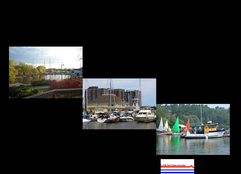
16 SECTION 2 EXISTING RECREATIONAL BOATING FACILITIES IN HALTON REGION 2.0 Boating Facilities There are four marinas, three yacht clubs, one power boat club, and four boating clubs (providing opportunities for canoe, kayak, sailing, catamaran, outrigger canoe, and stand up paddle boards). In addition, the 25 hectare reservoir at Kelso Conservation Area (Milton), 202 hectare lake at Mountsberg Conservation Area (Milton) and 26 hectare Fairy Lake at Prospect Park (Acton-Halton Hills) all in the northern part of Halton provide launch ramps and the opportunity to use small aluminum boats, canoes, kayaks, paddle boats and stand up paddle boards. Each of these facilities is listed in Table 1 below and shown in Figures 1 to 4 following. Table 1 - Boating Facilities in Halton Facility Location Boating Activity Marina Oakville Harbours Marina - Oakville Lakeshore Road East Sail boats, power boats Harbour Oakville Harbours Marina - Bronte 2508 Lakeshore Road West Sail boats, power boats Harbour Bronte Outer Harbour Marina 2340 Ontario Street, Bronte Sail boats, power boats, Halton Police Marine Unit LaSalle Park Marina 831 LaSalle Park Road, Burlington Sail boats, power boats Yacht Club Oakville Club 56 Water Street, Oakville Sail boats, kayaks, stand up paddle boards Oakville Yacht Squadron 146 Lakeshore Road West, Oakville Sail boats Bronte Harbour Yacht Club 2514 Lakeshore Road West, Bronte Sail boats, power boat, dinghies Power Boat Club Oakville Power Boat Club 150 Water Street, Oakville Power boats Boating Club Burloak Canoe Club 160 Water Street, Oakville Canoes, kayaks, war canoes, dragon boats Burlington Sailing and Boating Club 841 LaSalle Park Road, Burlington Dinghies, keel boats, power boats Burlington Beach Catamaran Club Lakeshore Road, Burlington Catamarans Wai Nui O Kanaka Outrigger Canoe Club 2479 Hixon Street, Oakville Outrigger canoes, stand up paddle boards Conservation Area and Park Kelso Conservation Area 5234 Kelso Road, Milton Canoes, kayaks, paddle boats, stand up paddle boards, small aluminum boats (motorized boats prohibited) Mountsberg Conservation Area 2259 Milburough Line, Campbellville (Milton) Canoes, kayaks, paddle boats, stand up paddle boards, small aluminum boats (powered by electric trolling motors permitted, gas powered motor prohibited ) Fairy Lake, Prospect Park 30 Park Avenue, Acton (Halton Hills) Canoes, kayaks, stand up paddle boards, small aluminum boats (powered by electric trolling motors permitted, gas powered motor prohibited) Coronation Park 1426 Lakeshore Road West, Oakville Canoes, kayaks, paddle boats, stand up paddle boards, small aluminum boats Burloak Waterfront Park 5420 Lakeshore Road East, Burlington Canoes, kayaks, paddle boats, stand up paddle boards, small aluminum boats 2.1 Amenities and Services The four marinas, three yacht clubs and one power boat club have 1,344 slips and moorings, of which 137 are mediterranean bow in moorings 1 (i.e. Oakville Club 43, Oakville Yacht Squadron 76, Bronte Harbour Yacht Club 18). Of the 1,344 slips available in Halton only 34 are transient and none of these TOURISTICS + Shoreplan Engineering Limited 3

17 Figure 1 - LaSalle Park Marina TOURISTICS + Shoreplan Engineering Limited 4

18 Figure 2 - Oakville Harbour TOURISTICS + Shoreplan Engineering Limited 5

19 Figure 3 - Bronte Harbour TOURISTICS + Shoreplan Engineering Limited 6

20 Figure 4 - Halton Region Facilities TOURISTICS + Shoreplan Engineering Limited 7
21 are at the Oakville or Bronte Harbour Marinas. All but 10 are available at the Bronte Outer Harbour Marina. 446 of the slips are less than 30 feet; 592, 30 feet to less than 36 feet; 271, 36 feet to less than 46 feet; and 35, 46 feet and over (EXHIBIT 1A). Only Bronte Outer Harbour Marina and Bronte Harbour have permanent lift facilities; cranes are brought in in the spring and fall for the launch and haulout at the other six facilities. Bronte Harbour offers repairs through a marine shop operated by an independent owner. The facility is leased from the Town of Oakville. Only two of the eight facilities provide a fuel dock (i.e. Oakville Power Boat Club, Bronte Outer Harbour Marina) and only the fuel dock at Bronte Outer Harbour Marina is available to both power and sail boats as only boats that clear the bridges (32 foot clearance) can make it to the Oakville Power Boat s fuel dock. There are four launch ramps; one in Oakville Harbour, one in Bronte Harbour, and two at the LaSalle Park Marina in Burlington. The five launch ramps at Kelso and Mountsberg Conservation Areas, Fairy Lake, and Coronation Park are only suitable for canoes, kayaks and small boats as there are either physical or other operational restrictions on the use of motorized boats at these locations (Figure 4). There is potential for a launch ramp at Burloak Waterfront Park suitable for canoes, kayaks and small boats. A master plan review of the park is currently underway. Oakville Power Boat Club, Bronte Outer Harbour Marina, Oakville Harbour Marina, and LaSalle Park Marina (shared with BSBC) offer the only pump out services in Halton. Just over half of the slips (i.e. 687) have access to 30 or more amp. power pedestals. Only 71 percent or 928 of the 1,310 seasonal boats at the eight facilities can be accommodated on-site for winter storage. Another 40 could be accommodated within Oakville Harbours Marina if the abandoned boats were removed (EXHIBIT 1B). 2.2 Seasonal and Transient Slip Users During the 2013 boating season 96.8 percent of the 1,310 seasonal slips were occupied. Anything over 95 percent is considered full occupancy by industry standards. Some slips were not occupied in 2013 due to spring storm damage to the marina infrastructure at LaSalle Park Marina and wet moorings required for the pilot dredging project in Bronte Harbour. As shown in Figure 5 below, 84.8 percent (1,075) of the seasonal slips at the eight facilities were occupied by residents of Halton, 57.7 percent (732) by residents of Oakville, 22.7 percent (288) by residents of Burlington, and 4.4 percent (55) by residents in the rest of Halton. Sixty percent or 767 of the 1,268 seasonal boats in 2013 were sail boats and 501 power boats (EXHIBIT 1C). There were 470 boats on the waiting lists of the eight facilities with 73 percent looking for a slip 36 feet or more in length. This represents 37.1 percent of the occupied slips in 2013 Despite the low number of transient slips available within Halton, 1,287 boaters visited the area facilities in 2013, staying for an average of 1.5 days. This number of transient visits is primarily due to the reciprocal arrangements at the yacht clubs where visiting boats can use member slips when they are vacant. If transient slips were available within Oakville Harbour and Bronte Harbour we believe this number would be substantially higher. 1 In a Mediterranean mooring, the bow (front) of the boat is tied to a fixed structure (in the case of the harbours, a dock) while the stern (back) is tied off to two floating devices, customarily tires that are themselves anchored to the bottom of the harbour and that are usually deployed only during the boating season. The boat approaches the shoreline at a perpendicular angle, runs two lines to the shore (dock) and another two to the floating moorings. The advantage of Mediterranean mooring is that many more boats can be accommodated along a fixed length of shoreline as there are no finger docks separating the boats. The disadvantage is that embarking and disembarking the boat must be made from the bow of the boat which is not as easy as, and is less stable than using a finger dock alongside. TOURISTICS + Shoreplan Engineering Limited 8

22 Figure 5 - Residence of Boat Owners at Seasonal Slips 4.4% 15.2% 22.7% 57.7% Oakville Burlington Milton-Halton Hills Outside of Halton Region 2.3 Assessment of Infrastructural Features at Boating Facilities The conditions of the existing facilities were reviewed at the three main boating locations within the Region. These locations include LaSalle Park in Burlington, Bronte Harbour and Oakville Harbour. The review was limited to a visual assessment of the facilities and observations of their function and boater use (EXHIBIT 1D and 1E). No surveys, measurements or testing of the structures were undertaken. The review did not include buildings or club houses. Comments with respect to adequacy of fairways are based on a review of aerial photography. A fairway twice the length of a boat using the adjacent dock is considered good and a fairway width of one and onehalf of the length of the boat is considered adequate. Water depth requirements depend on boat mix but generally water depths of 1.8 metres are considered adequate for public marinas. Chart datum is taken as reference water level. Comments with respect to stability of docks are based on experiences during site visits and comments received from boaters and may be considered somewhat subjective. Comments regarding launch ramp parking follow published recommendations that suggest 40 car/trailer combination parking spaces are required per launch lane. However, it is recognized that demand for parking varies from location to location and by time of day. Plans of the facilities are provided on the previously noted Figures 1 to 3. The reader should refer to these figures while reading the description in this sub-section of the report La Salle Park LaSalle Park provides the base of LaSalle Park Marina and the Burlington Sailing and Boating Club. The facilities are located on or adjacent to the LaSalle Park Pier. The La Salle Park Marina facilities are located on the east side of the pier and include floating docks and a floating breakwater. The docks and the breakwater are removed every fall and reinstated in the spring. The docks and their use are being hampered by excessive wave activity due to a functionally inadequate floating breakwater. Damage to the docks and boats is frequent. The operation of the marina and specifically the provision of proper wave protection for the marina was the subject of a recently completed Class Environmental Assessment (Dillon Consulting Limited, 2013). The Environmental Study Report concludes that a fixed breakwater is the preferred method of resolving the ongoing wave related TOURISTICS + Shoreplan Engineering Limited 9
23 problems. Any comments with respect to the docks are not material until the basin is properly protected. The spacing of the docks and fairway widths are appropriate for the size of the slips. Water depth is greater than required in most of the basin. Approximately 20 percent of the dock area in the north part of the basin has a water depth of less than 1.8 metres at Chart Datum. Boats with shallow draft are assigned to this part of the basin. The park also includes two launch ramps, one located on the east side of the pier and another located on the west side of the pier. The east ramp is used by the public to launch small to moderate size boats transported on trailers behind cars and trucks. The ramp surface accommodates two launching lanes. The slope of the ramp appears to be within an acceptable slope gradient and deep enough to accommodate launching under a typical range of water levels. Fixed piers and extended floating docks are provided on both sides of the ramp. Segregated parking for the launch ramp is not provided. The west ramp is located directly in front (south) of the Burlington Sailing and Boating Club (BSBC). Although not dedicated for exclusive use of the club, it is not readily accessible from the public parking lot. It is a single lane structure. The launch ramp had a number of problems including rough surfaces and inadequate depth in the past and is presently under re-construction. It is re-designed to operate under the full range of water levels experienced during a typical boating season. The launch ramp is flanked with floating docks installed by BSBC in the spring and removed in the fall Bronte Harbour The Bronte Harbour area includes two distinct boating facilities. The Bronte Outer Harbour Marina is located east of the mouth of the Bronte Creek and is a privately operated facility under a long term lease from the Region. The boating facilities within the mouth of the creek include the municipal facilities operating as Oakville Harbour Marina and the Bronte Harbour Yacht Club. The Bronte Outer Harbour Marina is the most recently constructed boating facility on the Halton waterfront. The facility has floating docks. They appear to be stable and well secured. Access to the docks is controlled with security gates. The shore treatments are in good condition. There appears to be no physical deficiencies in these facilities. Reports of excessive wave penetration into the basin under southwest wind conditions were provided by boaters. The docking facilities along the river within the Oakville Harbour Marina are generally arranged directly off the shore walls of the creek with three additional main docks extending into the creek beyond the shore connected docks. Two of the three additional main docks have fingers attached. The third main dock supports boats docked bow-in with stern float anchors. The stability of the main docks and main docks with fingers is considered to be adequate. The stability of the finger docks attached directly to the shore walls is considered poor. The width of fairways varies in various parts of the harbour from adequate to inadequate. There are parts of the harbour where fairways are just equal to the length of boats docked in the area. The seawalls are constructed of various materials but most commonly of concrete blocks or steel sheet piles. The concrete block walls appear to be functional. The walls do not show excessive settlement or lean. The backshore, which is mostly made up of interlocking pavement surfaces or boardwalk also does not show an excessive amount of settlement or movement. This is considered important given that the soils around the harbour are very soft sediments with organic content. There are two launch ramps within the river channel. A public launch ramp is located on the south side of the river and specific car/trailer parking is provided adjacent to the ramp. The launch ramp has two lanes. There are nine parking spots provided which is considered substandard for the launch ramp. Public parking related to the park is available and is configured in such a way that it can be used as overflow for the launch ramp. The ramp surface appears relatively steep but not excessively so. We observed no docks available to assist in launching. A second set of launch ramps are available in the Bronte Harbour Yacht Club compound. These are single lane launch ramps and are separated by a mast crane slip. These launch ramps appear to be available for the use of the club members only. TOURISTICS + Shoreplan Engineering Limited 10
24 The water depth within the mooring area of the river varies. Oakville undertakes regular dredging operations and dredges the river to 2 m below Chart Datum regularly. The interval between dredging operations is approximately seven years, but may vary. The water depth in the mooring areas will gradually decrease after dredging and the operations will become hindered by reduced water depth over time. Oakville experimented with ongoing dredging operations using a small suction dredge and filtering the dredged material through geotextile bags. The results of the experimental operation are not known at this time. Oakville is also undertaking a sediment management study at Bronte Harbour at present time to better understand the sources of sediment and deposition process in the harbour Oakville Harbour Six marinas and boat clubs operate within the river mouth of Sixteen Mile Creek. These include Oakville Harbour Marina Oakville Harbour, Oakville Yacht Squadron, Oakville Club, Wai Nui O Kanaka Outrigger Canoe Club, Oakville Power Boat Club and the Burloak Canoe Club. Given the multiple operations, the descriptions are provided on club/marina basis. The entrance to Oakville Harbour is formed with two breakwaters. The west breakwater is a steel sheet pile pier with a concrete cap. At the north end of the west breakwater is a short armour stone groyne which extends approximately 30 m into the entrance channel. The armour stone groyne breaks waves that propagate up the entrance channel. The east breakwater is formed by a SSP pier with a concrete cap. Repairs to the east breakwater were carried out in The Town of Oakville Water Air Rescue Force (TOWARF) is at the north end of the east breakwater. The shore along TOWARF is protected with rip rap and armour stone. Two slips used by TOWARF are located along this section of the shore. The TOWARF facility was not included in the review. The water depth within the mooring areas of Sixteen Mile Creek varies. Oakville regularly dredges the creek to 2 m below Chart Datum. The interval between dredging operations is typically ten years, but may vary. The water depth in the mooring areas will gradually decrease after dredging and the operations will become hindered by reduced water depth over time. Oakville last dredged Sixteen Mile Creek in the fall/winter of Oakville Harbour Marina - Oakville Harbour Oakville Harbour Marina operations within Sixteen Mile Creek include three locations. There are operations within the Oyster Bay area near the mouth of the creek, operations within the central part of the harbour south of the Lakeshore Bridge to Randall Street bridge and docking facilities in the uppermost part of the harbour. Each of these locations is described separately. Oyster Bay is the embayment along the west side of the river north of Tannery Park and south of Oakville Yacht Squadron (OYS). Oyster Bay s shore is protected with a pre-cast concrete block wall and armour stone wall. Oakville is now reconstructing the shoreline protection within Oyster Bay. The pre-cast concrete block wall is being replaced with a boulder berm and armour stone wall. The Oakville Harbour Marina docks within Oyster Bay are floating docks configured in a standard main dock/finger dock arrangement. They extend north from the south shore. The docks are adequate with respect to their width and stability. The width of the fairways within this area varies depending on the position along the dock. They are adequate on the river channel side in some areas and inadequate or substandard in most other areas. Fairways just marginally greater than the length of the boats were noted. The central part of the Oakville Harbour Marina operations includes both sides of the river south of the Randall Street bridge to OYS (Shipyard Park) on the west side and to Oakville Club on the east side. It also includes a launch ramp at the south end of Shipyard Park. The launch ramp is in poor condition and Oakville is in the process of redesigning the ramp as part of their Oakville Harbour West Master Plan redevelopment. TOURISTICS + Shoreplan Engineering Limited 11
25 The west shore north of the launch ramp is protected with a concrete block wall constructed in the 1990 s. The block wall extends along the shore of Shipyard Park and ends at the north side of Shipyard Lagoon. The wall appears to be in good condition. The shore north of Shipyard Lagoon is protected with an anchored SSP wall that was constructed in The north portion of the SSP wall under the bridge is protected with an armour stone wall constructed in North of the armour stone wall, the west shore is natural with no formal structures. Boats along the west shore mostly tie off bow-in along the shore with stern floating anchors. This same arrangement is used within the Shipyard Lagoon. The only exception to this is the shore under and within approximately 25 meters of the Lakeshore Road bridge. Here the docking is provided along a shore parallel floating dock tied off to shore anchor piles. Large boats dock parallel to the dock. The fairways within this part of the river are adequate except at the mouth of the Shipyard Lagoon. The east side of the river, north of the Oakville Club to the south side of the launch ramp near the Randall Street Bridge, is protected with a pre-cast concrete block wall similar in construction to the wall in Shipyard Park. The wall appears to be in good condition. Floating finger docks are secured to the wall and boats tie off to the finger docks. Boats dock either bow or stern-in. The stability of the finger docks is judged to be marginal. North of the Burloak Canoe Club, along the upper reach of the harbour, boats dock along both sides of a shore parallel floating dock. The larger boats dock along the creek side. One shore connection is centrally located along the dock. A set of stairs leads from the shore wall to the northeast corner of the public parking lot off Water Street. The stairs are gated. The dock appears adequate for its width and stability. The fairways are adequate Oakville Yacht Squadron The Oakville Yacht Squadron (OYS) is located north of Oyster Bay. The shoreline is protected with a precast concrete block wall and steel sheet pile (SSP) walls. The pre-cast concrete block wall extends along short sections of the north shore of Oyster Bay. The concrete wall appears to be in good condition. The steel sheet pile wall that runs along the south side of the OYS building is poor condition. A mast crane is located near the east end of the wall. The steel sheet pile wall along the east of the OYS site was reconstructed in It is in good shape and supports a public boardwalk located along the east side of the OYS site. The new wall ends at the public launch ramp at the south end of Shipyard Park. There are two main docks that extend south from the OYS site into Oyster Bay. The boats docks bow-in with stern anchors in a very tight configuration. There are no finger docks. The main docks are stable and width is considered adequate but the use is hindered by the bow of some boats extending over the dock. Boats also dock bow-in along the new wall on the east side of the site. Stern anchors are used to tie-off the boats from the wall The Oakville Club The shore along The Oakville Club (OC) from the tennis court to the north side of the building is protected with a SSP wall. The wall is covered with a timber deck. Steel rings are attached either to the cap of the SSP wall or to the timber deck. Boats tie off to the steel rings secured to the SSP wall and deck. Short finger docks supported off the deck provide access to the boats. The wall is rusted and sections of the wall are leaning toward the lake. The shore north of the OC building is protected with a gabion basket wall. The gabion basket wall is covered by a timber deck. Short finger docks supported from the timber deck and gabion baskets provide access to the boats moored along the shore. All boats are docked bow into the shore with stern floating anchors. The fairway, or the open channel of the river, is of appropriate width. TOURISTICS + Shoreplan Engineering Limited 12
26 2.3.7 Wai Nui O Kanaka Outrigger Canoe Club A steel sheet pile wall extends along the south and north sides of the launch ramp adjacent to the Randall Street bridge, under the bridge and a short distance into the Power Boat Club basin. The wall is heavily rusted at the water line. The Wai Nui O Kanaka Outrigger Canoe Club uses this area and the launch ramp. There appears to be no docks used by the club. The launch ramp surface accommodates one launching lane. The slope of the ramp appears to be within an acceptable slope gradient and deep enough to accommodate launching of the Canoe Club boats Oakville Power Boat Club There are two distinct parts to the Oakville Power Boat Club facilities. A basin is located directly north of the Randall Street bridge and additional docking is provided along the east side of the river. Descriptions are provided below for these two parts. The shore along the south side of the Power Boat Club basin is protected with a rip rap revetment. The east and north shore of the basin is protected with a stone filled timber crib. The timbers are round and the stone fill is visible in the gaps. A timber deck extends along the top of the crib. The deck is uneven. Vertical steel piles are intermittently driven in front of the crib. They may be used to support the deck. Some of the vertical piles are leaning into the basin. Overall, these structures are in very poor condition and their stability is uncertain. Finger docks supported on steel tube piles are located along the east and west sides of the basin. A floating main dock with fingers extends south from the north shore of the basin. Boats dock along shoreparallel floating docks on the south shore. The stability of the main and finger docks is unknown. The fairway width in the basin varies from inadequate to adequate. The north side of the entrance to the basin and the east shore of the creek north of the entrance are protected with gabion baskets. The baskets are broken and they have lost their stone fill. A timber deck supported on steel tube piles covers the gabion baskets along this shoreline. The portions of the structure reviewed are considered to be in poor condition. Finger docks supported on steel tube piles and channels extend from the deck into the creek. The docks are narrow but appear to be stable. The docks are constructed using various types and sizes of materials and do not appear to be designed to a uniform appearance and standard. Fuel can be purchased at the Power Boat Club. The fuel dock is supported on steel tube piles. A gas pump and a store are located on shore. Boats can moor along either side of the fuel dock. The dock appears narrow and stable Burloak Canoe Club The Burloak Canoe Club is located north of the Power Boat Club. A shore parallel dock, supported on steel tube piles, extends north along the east shore of the creek. Boats are moored along the dock and the dock appears stable. The fairway, or open channel of the river, is adequate. 2.4 Other Boating Facilities in Halton In addition to the marinas and yacht clubs, Halton is also home to four boating clubs (Burloak Canoe Club, Burlington Sailing and Boating Club, Burlington Beach Catamaran Club, Wai Nui O Kanata Outrigger Canoe Club) catering to non-motorized boating activities. The four clubs offer opportunities for participation with canoes, outrigger canoes, kayaks, war canoes, dragon boats, dinghies, keel boats, paddle boats and stand up paddle boards (EXHIBIT 2). All of these boating facilities report an increase in the number of programs offered and participants in these programs in The programs are offered to both children and adults. The Burlington Sailing and Boating Club and Wai Nui O Kanata Outrigger Canoe Club also offer programs for the disabled. The Oakville Club, Oakville Yacht Squadron and Bronte TOURISTICS + Shoreplan Engineering Limited 13
27 Harbour Yacht Club offer junior and adult sailing schools for their members, and indicate that the numbers of participants in their sailing programs are also growing. The Oakville Yacht Squadron and Bronte Harbour Yacht Club also offer sailing lessons to the general public. The Bronte Harbour Yacht Club also offers a one week blind sailing program each summer. Kelso Conservation Area, Mountsberg Conservation Area and Fairy Lake in the northern part of Halton and Burloak Waterfront Park offer an opportunity for use of canoes, kayaks, paddle boats, stand up paddle boards, and small aluminum boats. Motorized boats are prohibited at Kelso, but boats with electric trolling motors are permitted at Mountsberg and Fairy Lake. There are no restrictions on motorized boats at Burloak Waterfront Park but physical barriers exist that limit access to the lakeshore. Mountsberg Reservoir caters mostly to fishermen than to the other forms of boating and sees as many as 200 boats involved in fishing on a good day. As a result of the tree stumps and occasional low water levels, stand up paddle boards are not encouraged at Mountsberg. Fairy Lake is also used more by fishermen than other forms of boating. The Town of Halton Hills does not monitor the level of use on the Lake; as a result there are no data available regarding the different activity uses. Kelso offers boat rentals from late April to early October for single and double kayaks, canoes, paddle boats, and stand up paddle boards (EXHIBIT 3). 2.5 Comparison of Halton s Boating Facilities with those of the GTA/Golden Horseshoe Area Boating Facilities There are 41 boating facilities in the GTA/Golden Horseshoe Area between Scarborough in the east and St. Catharines in the west. Of these 14 are marinas and the remaining 27 are yacht, sailing and cruising clubs Amenities and Services The 41 boating facilities offer 9,339 slips or moorings of which 8,833 are seasonal and 506 dedicated as transient or reciprocal slips or moorings. 1,830 of the slips are less than 30 feet; 4,361, 30 feet to less than 36 feet; 2,077, 36 feet to less than 46 feet; and 800, 46 feet and over (EXHIBIT 4A). Twenty two of the facilities provide a fuel dock. Thirty two have a pump out. There are 29 launch ramps available for use by boats typically 26 feet or less in length (i.e. 7.9 metres). Almost 80 percent (78.6%) of the slips (i.e. 7,130) have access to 30 or more amp. power. More than 85 percent (87.4%) of the 8,709 seasonal boats can be accommodated on-site for winter storage (EXHIBIT 4B) Seasonal and Transient Slip Users During the 2013 boating season 98.6 percent of the 8,833 seasonal slips were occupied. The remaining slips were not occupied due to long-term maintenance repairs and unsuitable lengths for the boats requiring a slip. Seasonal boats were almost evenly split between power (50.9%) and sail (49.1%). There were 1,450 boats on the waiting lists of the 41 facilities with 22 percent looking for a slip 46 feet or more in length (EXHIBIT 4C). This represents an additional 16.4 percent of needed supply Facilities in Halton Compared with the GTA/Golden Horseshoe Area As shown in Table 2 following, although the occupancy rates and percentage of slips by length are similar, boaters at marinas and yacht clubs in Halton appear to be less well served than those in GTA/Golden Horseshoe area. As a percentage of total slips available, the GTA/Golden Horseshoe area offers twice as many transient slips as Halton and as a percentage of facilities, twice as many fuel docks. Although a higher percentage of facilities in the GTA/Golden Horseshoe area offer a pump out service, the number of slips per pump out is similar (i.e. 292 versus 336 in Halton). Both areas have insufficient TOURISTICS + Shoreplan Engineering Limited 14
28 on-site capacity to accommodate all the seasonal boats for winter storage (i.e. 70.8% in Halton versus 87.4% in the GTA). The demand for additional slips is much higher in Halton than the GTA as expressed by the number of boats on the waiting list as a percentage of occupied seasonal slips (i.e. 37.1% in Halton versus 16.9% in the GTA/Golden Horseshoe area). Table 2 - Boating Facilities in Halton Compared to the GTA/Golden Horseshoe Area Halton GTA/Golden Horseshoe Area Number of Marinas, Yacht, Sailing and Power Boat Clubs 8 41 Seasonal Slips Occupied 1, % 8, % Transient Slips as Percentage of Total 2.5% 5.4% Slips Percentage of Slips <30 feet 33.2% 20.2% Percentage of Slips 30 feet to <36 feet 44.0% 48.1% Percentage of Slips 36 feet to <46 feet 20.2% 22.9% Percentage of Slips 46 feet and over 2.6% 8.8% Percentage of Facilities with Fuel Docks 25% 53.7% Number of Slips Per Fuel Dock Percentage of Facilities with Pump Out 50% 78.0% Number of Slips Per Pump Out Percentage of Facilities with Launch 37.5% 53.6% Ramp Percentage of Slips with 30 amp or more 51.5% 78.6% power Percentage of Seasonal Boats 70.8% 87.4% Accommodated On-site for Winter Storage Number of Boats on Waiting List 470 1,470 Boats on Waiting List as a Percentage of Occupied Seasonal Slips 37.1% 16.9% Source: EXHIBIT 1 and EXHIBIT Marina Rates and Fees in Halton Compared with the GTA/Golden Horseshoe Area We have compared the rates and fees to be charged at Bronte Outer Harbour Marina, Bronte Harbour, Oakville Harbour, and LaSalle Park Marina during the 2014 boating season with those at eleven marinas in the GTA/Golden Horseshoe Area offering the same facilities and services (EXHIBIT 5). These services include: Slip with at least 30 amp power and water; Summer land storage; Cradle/trailer storage; Mast stepping/un-stepping; Pump out service; Transient slip; Launch ramp; Haul-out or launch; and, Winter storage. Outer Harbour Marina in Toronto has the highest seasonal slip rental at $94.45 per linear foot, followed by Fifty Point Marina in Winona at $92.60 and LaSalle Park Marina the least expensive at $66.00 per linear foot. The rates charged at Bronte Outer Harbour Marina, Bronte Harbour, Oakville Harbour, and LaSalle Park Marina are comparable with those in the GTA/Golden Horseshoe Area given the product offering. Outside of Halton only Lakefront Promenade at $66.37 per foot and Port Credit Harbour Marina at $68.33 per foot are lower than Bronte Outer Harbour Marina at $73.00 per linear foot. The fees for summer land storage, cradle/trailer storage, mast stepping/un-stepping, pump out services, transient slip rentals, use of the launch ramp, and haul-out or launch are similar at all fifteen marinas and harbours. TOURISTICS + Shoreplan Engineering Limited 15
29 We compared the cost of winter storage based on a per square foot package cost for a 30 foot boat with a beam of 10 feet. 1 While winter storage at Bronte Outer Harbour at $5.35 per square foot is only exceeded by the $5.60 per square foot charged at Outer Harbour Marina in Toronto the rates charged at Bronte and Oakville Harbours and by the Burlington Sailing & Boating Club at LaSalle Park are in keeping with those at other facilities outside Halton (EXHIBIT 5 and 6). In fact, the winter storage rate charged by the Burlington Sailing & Boating Club is the lowest at $2.28 per square foot or approximately one-half of that charged at Bronte Harbour (i.e. $4.01/sq. ft.) and St. Catharines Marina (i.e. $4.00/sq. ft.) the next lowest two. As a further analysis of the rates charged within Halton and the GTA/Golden Horseshoe Area we undertook to compare them based on 17 facilities and services considered by boaters to be the most desirable features in a marina (EXHIBIT 7). 2 Each of the 15 marinas was evaluated based on features and values. Where a marina had a feature or service, but it was considered in need of improvement a lesser value was assigned (i.e. 4 rather than 5 for docks, 2 rather than 3 for a launch ramp) (EXHIBIT 8). Based on this assessment Harbour West Marina in Hamilton was the only marina receiving a maximum 62 point facility rating. Bronte Outer Harbour Marina received a score of 56, Bronte Harbour 44, LaSalle Park Marina 43, and Oakville Harbour 40, (Table 3). Improvements are planned Bronte Harbour, LaSalle Park Marina, and Oakville Harbour which will improve these scores Annual Rate Increases Our interviews with marina operators throughout the GTA/Golden Horseshoe Area indicated that annual rate increases are typically held to three to four percent due to the highly competitive nature of the market place and the fear of losing boaters if rates are increased too much in one season. Since there are no indications that marina operating costs will decrease in the future, it is expected that rates will continue to rise at this rate. One-time increases above three to four percent do occur when additional revenue is required for capital improvements. Rate increases at Bronte Outer Harbour Marina, Bronte and Oakville Harbours, and LaSalle Park Marina have consistently fallen within the area norms. LaSalle Park Marina uses the Bank Of Canada Consumer Price Index (CPI) as a minimum in setting their annual rates. When above normal increases in rates are necessary, it is good business practice to inform the long-term boaters as to the reason for this need (i.e. unusually high dredging costs, winter storm damage, major infrastructure improvements, etc.). It also has to be realized that operating marinas is a business and businesses at worst are expected to break-even but more realistically are expected to be revenuepositive. An annual capital reserve for replacement of 10 to 12 percent of gross revenue when possible is generally sufficient to cover major capital improvements within the 20 to 25 year life cycle of the marinas major infrastructure features and should be included in all marina and harbour budgets.. 1 Winter storage package includes (haul-out, bottom wash, storage, launch) 2 50 boat owners were interviewed at the Toronto International Boat Show between January 12 and 18, 2014 regarding the features they felt were most desirable at a home marina. They were then asked to rate each feature on a scale of 1 to 5, with 5 being the most desirable. The rating values are virtual the same as those used in the Association of Oakville Harbours Stakeholders 2012 Rates and Fees Study TOURISTICS + Shoreplan Engineering Limited 16
30 Table 3 - Evaluation of Halton s Harbours Boating Facilities Facility Facility Rating Missing or Features in Need of Improvement Bronte Outer Harbour Marina 56 No launch ramp, repair service or laundry facilities Bronte Harbour 44 Finger docks in need of improvement; No pump out, fuel dock, WiFi connection, laundry facilities; Staff not available for assistance, launch ramp needs improvement LaSalle Park Marina 43 Docks in need of improvement; potable water and 30 amp power not available at all finger docks; No fuel dock, repair services, marine supplies, mast crane or laundry facilities; Staff not always available for assistance, launch ramps needs improvement Oakville Harbour 40 Docks in need of improvement; No 24 hour security, fuel dock, WiFi connection, repair services, marine supplies, laundry facilities; Staff not available for assistance, launch ramp needs improvement Source: EXHIBIT 7 and 8 TOURISTICS + Shoreplan Engineering Limited 17
31 TOURISTICS + Shoreplan Engineering Limited 18
32 SECTION 3 PROFILE OF BOATERS AND POPULATION CHARACTERISTICS 3.0 Introduction This section provides a socio-demographic profile of boaters in Ontario; an indication of how these sociodemographic characteristics compare with those of Halton s residents; projections of Halton s population between 2013 and 2031; and projected participation rates for a number of the existing boating activities in Halton. 3.1 Socio-demographic Profile of Sail and Power Boaters In 2011, 14.5 percent of Ontario s population 16 or over participated in boating. 1 The participation rate by males (i.e. 15.8%) is only slightly higher than that for females (i.e. 13.3%). For both males and females the highest participation rate is in the 35 to 44 and 45 to 54 age group (i.e. 22.9% and 19.0% respectively for males and 18.9% and 16.3% respectively for females) (Figure 6). Power and sail boaters are represented in all levels of attained education, although those with some university education and those with a university degree are the highest at 21.2 percent and 25.5 percent respectively. While boating also appeals to all employment categories, those employed in professional, administrative and managerial, and skilled labour positions have the highest participation rates at 28.8 percent and 24.6 percent respectively. The largest number of boaters come from households earning $40,000 to $74,999, although the highest participation rate is within those from households earning $100,000 or more. 3.2 Socio-demographic Characteristics of Burlington, Oakville and Halton Residents There are 493,045 persons living in Halton, including 174,780 residing in Oakville, and 173,761 in Burlington according to the Best Planning Estimates, June It is evident when looking at the sociodemographic characteristics that have the highest propensity to participate in boating (e.g. education, occupation, household income) that Halton, Oakville and Burlington are a strong market for power and sail boating participation. Among males 35 to 44, the age group with the highest participation in boating (i.e. 22.9%), Halton and Oakville are slightly under-represented when compared to the province (i.e. 15.6% and 15.0% respectively, compared to 15.8% for Ontario. The second highest participation rate among males falls in the 45 to 54 year age category (i.e. 19.0%); in this case all three areas are overrepresented when compared to the province (i.e. 16.3%, 17.5%, 16.0% and 15.3% respectively) (EXHIBIT 9 and Figure 6). A similar pattern occurs with the proportion of females compared to the province. The proportion of the female population within Halton (i.e. 16.0%), and Oakville (i.e. 16.2%), is over-represented compared to the province (i.e. 15.7%) in the 35 to 44 age group which has the highest participation rate in boating (i.e. 18.9%). Females in the 45 to 54 age group, the category with the second highest participation rate in boating (i.e. 16.3%) are over-represented in all three areas when compared to the province with Oakville being the most over-represented (i.e. 17.3% vs. 15.3%). Burlington is the least over-represented at 15.8% followed by Halton Region at 15.9%. In our meeting with the Association of Oakville Harbours Stakeholders the Commodores noted that the majority of their members fell in the 45 to 54 age group. The higher the level of education attained, the higher the level of participation in boating as shown by a 21.2 percent participation rate for those with some university education and 25.5 percent for those with a degree. All three areas are all well over-represented compared to that of the province among those with a university degree (i.e. Halton 26.3%; Oakville 32.6%; and Burlington 23.7%) compared to 20.5% for the province. Those with some university education are also over-represented in all three geographic market areas when compared to the percentage of all those in Ontario (i.e. 4.7%, 5.6%, 4.5% compared to 4.1% respectively). 1 Statistics Canada, General Social Survey and Ontario Ministry of Tourism, Culture and Sport TOURISTICS + Shoreplan Engineering Limited 19
33 Figure 6 - Boating 1 Participation in Ontario Percentage of any group age 16 or over that participated in boating at any time in 2011 Boating Motor Boating Sailing 3.6% 10.8% 14.5% Males Boating Motor Boating Sailing 3.7% 11.8% 15.8% 16 to to to to to % 14.7% 16.6% 17.8% 19.0% 22.9% Females Boating Motor Boating Sailing 3.4% 9.8% 13.3% 16 to to to to to % 12.5% 15.4% 16.3% 14.1% 18.9% 0% 5% 10% 15% 20% 25% 1 Includes in-board and out-board motor boating and sailing, excludes canoeing, kayaking and motorized personal watercraft TOURISTICS + Shoreplan Engineering Limited 20
34 Figure 6 - Boating Participation in Ontario (Continued) Percentage of any group age 16 or over that participated in boating at any time in 2011 Non High School Graduate High School Graduate Some University University Graduate All Others 11.5% 14.6% 15.2% 21.2% 25.5% Professional/Admin Clerical/Sales Skilled Non-Skilled 19.7% 19.9% 24.6% 28.8% Under $20,000 $20,000 to $39,999 $40,000 to $74,999 $75,000 to $99,999 $100, % 12.9% 19.2% 28.7% 32.6% 0% 5% 10% 15% 20% 25% 30% 35% Source: Statistics Canada, General Social Survey and Ontario Ministry of Tourism, Culture and Sport TOURISTICS + Shoreplan Engineering Limited 21
35 Occupation is a socio-demographic characteristic that is also a strong determinant of participation in boating. Within Halton, Oakville and Burlington there are proportionally more individuals in professional/managerial/administrative occupations (i.e. 53.1%, 57.1%, and 41.9% respectively compared to the province s 45.7%), the occupation category with the highest participation level in boating (i.e. 28.8%). On the other hand, skilled labour persons who have the second highest participation rate in boating (i.e. 24.6%) are under-represented in all three geographic areas (i.e. 18.1% in Halton, 16.1% in Oakville, and 17.7% in Burlington) compared to 21.1 percent in Ontario. Despite being underrepresented in skilled labour there are still approximately 51,400 individuals in Halton employed in this category, 16,000 in Oakville, and 17,600 in Burlington. Household income is the strongest determinant for participation in boating. Median household income in Halton is 38.1 percent higher than the province (i.e. $83,496 versus $60,455). In Oakville the median household income ($92,394) is 52.8 percent higher and in Burlington ($74,969) 24.0 percent higher than the province. Within the income group $75,000 to $99,999; which has the second highest participation rate in boating (i.e. 28.7%), all three areas are under-represented: Halton by 1.4 percent, Oakville by 3.3 percent and Burlington by 1.1 percent (i.e. 12.1%, 10.2%, and 12.4% respectively compared to 13.5% for Ontario). Households with an average income of $100,000 or more have the highest participation rate in power and sail boating at 32.6 percent. In this case, all three areas are well over-represented when compared to the rest of Ontario, with Halton at 45.4 percent, Oakville at 49.2 percent, and Burlington at 39.3 percent compared to the province s 16.8 percent. 3.3 Projected Population of Halton 2013 to 2031 There are no data available other than by age and gender characteristics which project the population of Halton over the next twenty year period. Therefore we have used the Region s Best Planning Estimates, June 2011, as a base along with the Ontario Ministry of Finance s, Ontario Population Projection Update, , Spring 2013, and Greater Golden Horseshoe Growth Forecasts to 2041, Technical Report, November 2012, Hemson data to arrive at projections for each year (EXHIBIT 10). The population of Halton 25 and older 1 is projected to increase from 359,130 in 2013 (169,920 males, 189,210 females) to 403,630 by 2018 (196,670 males, 206,960 females), to 451,670 by 2023 (220,220 males, 231,450 females), to 498,180 by 2028 (243,520 males, 254,660 females), and reach 528,100 by 2031 (258,250 males, 269,850 females), (Figure 7). This represents a 47 percent increase in the population between 2013 and During this same time period the population of Ontario 25 and older is projected to increase by only 25.5 percent from 9,614,530 (4,661,300 males, 4,953,230 females) in 2013, to 12,064,180 (5,850,820 males, 6,213,360 females) in 2031 (EXHIBIT 11). The period between 2011 and 2031 will also see a 53.9 percent increase in employment in Halton while that of the province will increase by 26.8 percent. 2 The increased growth in the age groups with high participation rates in boating (i.e. 35 to 44 and 45 to 54) and employment in Halton indicates a likely large increase in the demand for recreational boating activities and a larger share of Ontario s power and sail boaters (Figure 8). 3.4 Projected Growth in Boating Activities Between 2011 and 2030 participation in power boating, sailing, canoeing, kayaking and rowing are all projected to increase. There are no comparable projections available for outrigger canoeing, paddle boating, and stand up paddle boarding, although anecdotal information based on the increased number of members at area clubs suggests that participation in these activities is also in a growth mode. 1 Very few power or sail boats are owned by those under 25 2 Greater Golden Horseshoe Growth Forecasts to 2041, Hemson Consulting Limited, 2012 and Ontario s Long-Term Report on the Economy, Ministry of Finance, 2010 TOURISTICS + Shoreplan Engineering Limited 22

36 Figure 7 - Halton Population Projections 2011 to 2031 (25 and over) Population of Halton Region 25 and older 80,000 70,000 60,000 50,000 40,000 30,000 20,000 10,000 0 Male Female Male Female Male Female Male Female Male Female Male Female Year 25 to to to to Note: Few boats are owned by those under 25, and the 25 to 64 age group categories have the highest participation rates in power and sail boating Based on data provided by Statistics Canada, General Social Survey and Ontario Ministry of Tourism, Culture and Sport (Figure 9) participation in power boating, sailing, canoeing, kayaking and rowing is projected to increase over the 20 years between 2011 and 2030 as follows: Power boating (10.8%) 2020 (13.0%) 2030 (14.6%) Sailing (3.6%) 2020 (4.3%) 2030 (4.8%) Canoeing (6.8%) 2020 (7.6%) 2030 (8.3%) Kayaking (2.4%) 2020 (4.4%) 2030 (5.4%) Rowing (3.0%) 2020 (3.1%) 2030 (3.3%) Based on these projected participating rates the number of male power and sail boaters in Halton in the age groups with the highest participation rates (i.e. 35 to 44 and 45 to 54) are expected in increase from 16,560 in 2013 to 17,440 in 2018, to 18,450 in 2023, to 20,140 in 2028 and reach 21,380 by Females in the same two age group categories are projected to increase from 14,560 in 2013, to 14,900 by 2018, to 15,830 by 2023, to 17,240 by 2028, and reach 18,240 by This represents a 29 percent increase in the number of male power and sail boaters and a 23 percent increase in the number of female power and sail boaters in Halton (Figure 10). Given that the slips and moorings in Halton were at capacity in 2013, there will be an increased need for additional slips in Halton each year between 2014 and TOURISTICS + Shoreplan Engineering Limited 23

37 Figure 8 - Projected Growth in Halton s Share of Ontario s Power and Sail Boaters Halton's Percentage of Ontario's Power & Sail Boaters Males Females Males Females Males Females Males Females Males Females Year Note: Based on number of males and females 25 years of age and older Figure 9 - Projected Growth in Percentage of Ontario s Population Participating in Selected Boating Activities Percentage of Population 16 or over Participating Year Power & Sail Boating Power Boating Sailing Canoing Kayaking Rowing Source: Statistics Canada, General Social Survey; Ontario Ministry of Tourism, Culture and Sport TOURISTICS + Shoreplan Engineering Limited 24
 35 to 44 (22.9% & 18.9% participation) 45 to 54 (19.0% & 16.3% participation) 55 to 64 (16.")
38 Figure 10 - Projected Growth in Number of Power and Sail Boaters in Halton (2013 to 2031) Number of Power & Sail Boaters 14,000 12,000 10,000 8,000 6,000 4,000 2,000 0 Males Females Males Females Males Females Males Females Males Females to 34 (17.8% & 15.4% participation) 35 to 44 (22.9% & 18.9% participation) 45 to 54 (19.0% & 16.3% participation) 55 to 64 (16.6% & 14.1% participation) 65+ (8.9% & 5.3% participation) TOURISTICS + Shoreplan Engineering Limited 25
Recreational Boating Feasibility and Capacity Study
 TOURISTICS + Shoreplan Engineering Limited were retained by: Town of Oakville; City of Burlington; and Regional Municipality of Halton. Note: Throughout the presentation boat lengths are identified in
Port Elgin Harbour Strategic Assessment. Study undertaken by TOURISTICS and Shoreplan Engineering Limited
 Study undertaken by TOURISTICS and Shoreplan Engineering Limited 1 Study included: Review of existing recreational boating facilities in Bruce and Grey Counties An analysis of trends in recreational boating
Port Elgin Harbour Strategic Assessment Final Report
 Port Elgin Harbour Strategic Assessment Final Report January 2018 i ii Table of Contents EXECUTIVE SUMMARY... ix SECTION 1 - INTRODUCTION... 1 1.0 Background... 1 1.1 Study Approach... 1 1.2 Report Format...
Waterfront User Needs Assessment & Detailed Design RESPONSE TO COMMENTS
 Waterfront User Needs Assessment & Detailed Design RESPONSE TO COMMENTS Town of Cobourg Presentation to Council Monday July 3, 2018 4 PM 1 Response topics Opportunity to clarify and correct misinterpretations
HARBOR INFRASTRUCTURE INVENTORIES Oak Orchard Harbor, New York
 HARBOR INFRASTRUCTURE INVENTORIES Oak Orchard Harbor, New York Harbor Location: Oak Orchard Harbor is located on the southern shore of Lake Ontario at the mouth of Oak Orchard Creek in the village of Point
Redondo Beach Boat Launch Ramp Facility
 Redondo Beach Boat Launch Ramp Facility Feasibility Report for the California Department of Boating and Waterways 2015 Grant Cycle For the City of Redondo Beach Submitted by March 13, 2014 Table of Contents
UBCM Community Excellence Awards 2007 Submission
 UBCM Community Excellence Awards 2007 Submission Formatted: Left: 2.54 cm Category: Partnerships Project: Implementation of False Creek Anchoring Management System 1. A one-paragraph summary of the project/program
LaSalle Park Marina Wave Break
 LaSalle Park Marina Wave Break Federal and Municipal Environmental Assessment Background History of the Marina and LaSalle Park The LaSalle Park Marina is located in LaSalle Park at the foot of LaSalle
HARBOR INFRASTRUCTURE INVENTORIES Fairport Harbor, OH
 HARBOR INFRASTRUCTURE INVENTORIES Fairport Harbor, OH Harbor Location: Fairport Harbor is located at the mouth of the Grand River on the southern shore of Lake Erie in the city of Fairport, OH, approximately
Burrard Bridge Civic Marina. Class B Marina (No Liveaboard Facilities) A Prime Location in the Heart of Downtown Vancouver
 A Prime Location in the Heart of Downtown Vancouver") Features 1661 443 Water Moorage Slips (21 ft to 38 ft) 149 Land Storage Berths 12 Rowing Compounds BURRARD BRIDGE 36 Canoe/Kayak Racks 1601 Class B Marina (No Liveaboard Facilities) A Prime Location in
Features 1661 443 Water Moorage Slips (21 ft to 38 ft) 149 Land Storage Berths 12 Rowing Compounds BURRARD BRIDGE 36 Canoe/Kayak Racks 1601 Class B Marina (No Liveaboard Facilities) A Prime Location in
Cobourg Marina and West Harbour Headland
 Cobourg Marina and West Harbour Headland Marina Expansion When I imagine Cobourg s future waterfront I see The boat storage moved and a rewilding of West Beach Keeping what we have in pristine repaired
APPENDIX A FINAL REPORT. Town
 APPENDIX A FINAL REPORT Phase Two of the Feasibility and Capacity Study Town of Oakville prepared by Engineering Limited May 2018 Harbours Master Plan: : Conceptual Marinas Phase Two of the Feasibility
APPENDIX 2 LAKESHORE ROAD TRANSPORTATION REVIEW STUDY EXECUTIVE SUMMARY
 APPENDIX 2 LAKESHORE ROAD TRANSPORTATION REVIEW STUDY EXECUTIVE SUMMARY Appendix 2 City of Mississauga Lakeshore Road FINAL REPORT Transportation Review Study December 2010 EXECUTIVE SUMMARY Study Purpose
Port Sections Guide Section 01
 s Guide 01 Cow Bay Marina Date 10/1/2016 Position (lat / lon) Minimum controlled water depth Chart datum Range of water densities Tidal range alongside Bottom type Dredging regime Distance pilot station
HARBOR INFRASTRUCTURE INVENTORIES West Harbor, OH
 HARBOR INFRASTRUCTURE INVENTORIES West Harbor, OH Harbor Location: West Harbor is located on the southern shore of Lake Erie in the township of Catawba Island, OH about 50 miles east of Toledo, OH. Authority:
The Economic Importance of Recreational River Use to the City of Calgary
 The Economic Importance of Recreational River Use to the City of Calgary Prepared by: Calgary River Users Alliance May 20, 2016 The Economic Importance of Recreational River Use to the City of Calgary
JUNEAU SECOND CHANNEL CROSSING WATERWAY USER SURVEY RESULTS
 JUNEAU SECOND CHANNEL CROSSING WATERWAY USER SURVEY RESULTS PREPARED FOR: HDR Alaska, Inc. PREPARED BY: Juneau Anchorage December 2003 TABLE OF CONTENTS Executive Summary...1 Introduction and Methodology...2
Canal Dock Boathouse, Inc. (CDBi) Paddle-Sports Request for Proposal Q & A Posted to CDBi website 9/16/2017
 Paddle-Sports Request for Proposal Q & A Posted to CDBi website 9/16/2017") Canal Dock Boathouse, Inc. (CDBi) Paddle-Sports Request for Proposal Q & A Posted to CDBi website 9/16/2017 *(All responses below are subject to further scrutiny by the City of New Haven and could be updated
Canal Dock Boathouse, Inc. (CDBi) Paddle-Sports Request for Proposal Q & A Posted to CDBi website 9/16/2017 *(All responses below are subject to further scrutiny by the City of New Haven and could be updated
Voting should indicate preference to one option (Option 1, Option 2, or Option 3)
") Proposals for Wied Il-Buni Options being considered for proposal for the Ministry of Infrastructure to be taken up with Transport Malta following the extension of Terminal 1 by Malta Freeport Corporation.
Proposals for Wied Il-Buni Options being considered for proposal for the Ministry of Infrastructure to be taken up with Transport Malta following the extension of Terminal 1 by Malta Freeport Corporation.
HARBOR INFRASTRUCTURE INVENTORIES Marquette Harbor, Michigan
 HARBOR INFRASTRUCTURE INVENTORIES Marquette Harbor, Michigan Harbor Location: Marquette Harbor is located in Marquette Bay on the south shore of Lake Superior, 160 miles west of Sault Ste. Marie, MI and
Washington State Parks comments to the Draft Clallam County Shoreline Master Program Update Consistency Review June 3, 2011
 Washington State Parks comments to the Draft Clallam County Shoreline Master Program Update Consistency Review June 3, 2011 Pg 10 Public access is typically discussed as a requirement placed on facilities
Surfing Tourism Destination Feasibility Study, Kincardine, Ontario
 Surfing Tourism Destination Feasibility Study, Kincardine, Ontario Prepared for: Regional Tourism Organization 7 and the February 24, 2014 EXECUTIVE SUMMARY With support from the Regional Tourism Organization
4 Ridership Growth Study
 Clause 4 in Report No. 15 of Committee of the Whole was adopted, without amendment, by the Council of The Regional Municipality of York at its meeting held on November 16, 2017. 4 Ridership Growth Study
Pier 8 Wave Overtopping Analysis (65 Guise Street East) Our File:
 Our File:") Shoreplan Engineering Limited 55 Eglinton Avenue E., Suite 800 Toronto, ON Canada M4P 1G8 T) 416.487.4756 F) 416.487.5129 E) mail@shoreplan.com March 31, 2016 Mr. Ed English Senior Project Manager Waterfront
Shoreplan Engineering Limited 55 Eglinton Avenue E., Suite 800 Toronto, ON Canada M4P 1G8 T) 416.487.4756 F) 416.487.5129 E) mail@shoreplan.com March 31, 2016 Mr. Ed English Senior Project Manager Waterfront
VISITING BOATS INFORMATION
 VISITING BOATS INFORMATION 2017 Seaham Harbour Marina is a joint venture between the Victoria Group and Durham County Council Marina Management Unit 10, The Waterside Seaham Harbour Marina, Seaham County
VIVA RETIREMENT COMMUNITIES OAKVILLE TRAFFIC IMPACT STUDY
 VIVA RETIREMENT COMMUNITIES OAKVILLE TRAFFIC IMPACT STUDY VIVA RETIREMENT COMMUNITIES OAKVILLE TRAFFIC IMPACT STUDY DECEMBER 2012 READ, VOORHEES & ASSOCIATES TORONTO, ONTARIO Read, Voorhees & Associates
Memorandum. To: City Council. cc: Tony Piasecki, City Manager Date: 3/3/2016. Introduction
 I Memorandum 211 To: City Council From: Joe Dusenbury, Harbormaster cc: Tony Piasecki, City Manager Date: 3/3/2016 Re: City Government 101 -The Marina Introduction Staff is presenting this material as
ROYAL VANCOUVER YACHT CLUB
 ROYAL VANCOUVER YACHT CLUB PROPOSED EXPANSION PROJECT NAVIGATION CHANNEL DESIGN COAL HARBOUR Prepared for: Royal Vancouver Yacht Club Prepared by: Typlan Consulting Ltd. March 2016 Page 1 of 17 March 23,
HARBOR INFRASTRUCTURE INVENTORIES Port Sanilac Harbor, Michigan
 HARBOR INFRASTRUCTURE INVENTORIES Port Sanilac Harbor, Michigan Harbor Location: Port Sanilac Harbor is located on the west shore of Lake Huron, about 30 miles north of Port Huron, MI. Authority: Rivers
CATAWBA YACHT CLUB RULES Approved 10/6/09
 CATAWBA YACHT CLUB RULES Approved 10/6/09 The Board of Governors has established the following rules, and the membership is hereby notified that they are in effect. For the purposes of these rules, the
HARBOR INFRASTRUCTURE INVENTORIES Lexington Harbor, Michigan
 HARBOR INFRASTRUCTURE INVENTORIES Lexington Harbor, Michigan Harbor Location: Lexington Harbor is located on the west shore of Lake Huron about 20 miles north of Port Huron, MI. Authority: Rivers & Harbors
Nome Harbor Page 2 of 12
 Nome Harbor Nome Harbor Page 2 of 12 Condition of Improvements 30 December 2015 Nome Harbor, Alaska (CWIS No. 010422, 012270, 072742, 087755) Authorization (1) Rivers and Harbors Act, 8 August 1917 (House
Number Details Action
 Minutes Present: Gosford City Council, RHDHV & Public Stakeholders. Apologies: From: Karen O'Mara & James Donald Date: Wednesday, 11 May 2016 Location: Gosford Sailing Club Copy: Our reference: M&APA1337M002F01
Final Draft of the Cobourg Marina Expansion - Operations and Facilities Study Stakeholder Meeting April 21, 10:00am Victoria Hall
 Final Draft of the Cobourg Marina Expansion - Operations and Facilities Study Stakeholder Meeting April 21, 10:00am Victoria Hall Note: This is the original submission with images added from the slide
HARBOR INFRASTRUCTURE INVENTORIES Caseville Harbor, Michigan
 HARBOR INFRASTRUCTURE INVENTORIES Caseville Harbor, Michigan Harbor Location: Caseville Harbor is located at the mouth of the Pigeon River on the east shore of Saginaw Bay, about 17 miles southwest of
LAKE DIANE Hillsdale County (T8-9S, R3W, Sections 34, 3, 4) Surveyed May Jeffrey J. Braunscheidel
 Surveyed May Jeffrey J. Braunscheidel") Michigan Department of Natural Resources Status of the Fishery Resource Report No. 2003-4, 2003 LAKE DIANE Hillsdale County (T8-9S, R3W, Sections 34, 3, 4) Surveyed May 2001 Jeffrey J. Braunscheidel Environment
Michigan Department of Natural Resources Status of the Fishery Resource Report No. 2003-4, 2003 LAKE DIANE Hillsdale County (T8-9S, R3W, Sections 34, 3, 4) Surveyed May 2001 Jeffrey J. Braunscheidel Environment
CBYC Cathedral Bluffs Yacht Club
 CBYC Cathedral Bluffs Yacht Club Report: THE IMPLICATIONS OF ACCEPTING LARGER BOATS AT CBYC Prepared for: CATHEDRAL BLUFFS YACHT CLUB 2009 / 2010 BOARD OF DIRECTORS Submitted by: THE STRATEGIC PLANNING
5 Year Recreation Plan Proposed Amendment Marina/Harbor/Boat Launch
 5 Year Recreation Plan Proposed Amendment Marina/Harbor/Boat Launch The DNR and Waterways Commission requires certain elements addressing marinas/harbors to be included in a communities 5 Year Recreation
Angling in Manitoba (2000)
") Angling in Manitoba (2000) TABLE OF CONTENTS Page Introduction 1 Angler Profile 2 Angling Effort 7 Catch and Harvest 10 Angling Expenditures 13 Bait Use 16 Nonresident Trip Characteristics 18 Angling in
Angling in Manitoba (2000) TABLE OF CONTENTS Page Introduction 1 Angler Profile 2 Angling Effort 7 Catch and Harvest 10 Angling Expenditures 13 Bait Use 16 Nonresident Trip Characteristics 18 Angling in
Introduction of the term Traffic Control Zone and formalization of Fraser River Traffic Control Zone procedures
 Consideration Report Introduction of the term Traffic Control Zone and formalization of Fraser River Traffic Control Zone procedures Background Under the Canada Marine Act, all Canada Port Authorities
Planning of Major Recreational Boating Facilities at Shell Cove Boat Harbour
 Planning of Major Recreational Boating Facilities at Shell Cove Boat Harbour B Morgan 1, Deborah Lam 1, Glenn Colquhoun 2 1 Advisian, Sydney, NSW 2 Frasers Property Australia, Shell Cove, NSW Abstract
Travel Patterns and Characteristics
 DRAFT 2006 Transportation Fact Book SECTION 4 Travel Patterns and Characteristics 43 2006 Transportation Fact Book DRAFT 44 DRAFT 2006 Transportation Fact Book Why do we conduct travel surveys? The main
ECONOMIC DEVELOPMENT ELEMENT
 ECONOMIC DEVELOPMENT ELEMENT Background The Economic Development Element considers labor force and labor force characteristics, employment by place of work and residence, and analysis of the community
BIRMINGHAM SAILING CLUB CLUB RULES
 Purpose The Club Rules are published separately from the By-Laws to provide guidance to members on the privilege of using club property. These Rules have been established to allow members to enjoy the
Docks and Moorings Policies & Procedures
 NORTH EAST RIVER YACHT CLUB Inc. Docks and Moorings Policies & Procedures Document Version: V-003 Status: Ownership Committee: Current Piers and Moorings Chairman (Dockmaster) Effective Date: BOG Approved
HARBOR INFRASTRUCTURE INVENTORIES Black Rock Lock & Tonawanda Harbor, NY
 HARBOR INFRASTRUCTURE INVENTORIES Black Rock Lock & Tonawanda Harbor, NY Harbor Location: The Black Rock Channel and Tonawanda Harbor are located along the east side of the Niagara River in the City of
HARBOR INFRASTRUCTURE INVENTORIES Harbor Beach Harbor, Michigan
 HARBOR INFRASTRUCTURE INVENTORIES Harbor Beach Harbor, Michigan Harbor Location: Harbor Beach Harbor is located on the west shore of Lake Huron about 60 miles north of Port Huron, MI. Authority: Rivers
Chapter 3 DESIGN SPECIFICATIONS
 Brampton PathWays Planning and Design Guidelines 27 Chapter 3 DESIGN SPECIFICATIONS 3.1 CLASS 1 MULTI-USE PATH Off-road multi-use trails are the backbone of the Brampton PathWays Network. They are typically
HARBOR INFRASTRUCTURE INVENTORIES Lorain Harbor, Ohio
 HARBOR INFRASTRUCTURE INVENTORIES Lorain Harbor, Ohio Harbor Location: Lorain Harbor is located on the southern shore of Lake Erie in the city of Lorain, OH about 45 miles west of Cleveland, OH. Authority:
Climate Change Action Plan: Transportation Sector Discussion Paper: Cycling
 Climate Change Action Plan: Transportation Sector Discussion Paper: Cycling ontario.ca/climatechange Contents 1. Minister of Transportation s message... 3 2. Introduction... 5 3. Sector Overview and Support
Fort Hancock Sailing Center
 Response to the National Parks Service Request for Expressions of Interest to Redevelop Historic Structures at Fort Hancock in the Sandy Hook Unit of Gateway National Recreation Area Fort Hancock Sailing
Technical Brief - Wave Uprush Analysis Island Harbour Club, Gananoque, Ontario
 Technical Brief - Wave Uprush Analysis RIGGS ENGINEERING LTD. 1240 Commissioners Road West Suite 205 London, Ontario N6K 1C7 October 31, 2014 Table of Contents Section Page Table of Contents... i List
Transportation Master Plan Advisory Task Force
 Transportation Master Plan Advisory Task Force Network Alternatives & Phasing Strategy February 2016 BACKGROUND Table of Contents BACKGROUND Purpose & Introduction 2 Linking the TMP to Key Council Approved
Ketchikan Harbors Thomas Basin and Bar Point Harbor
 Ketchikan Harbors Thomas Basin and Bar Point Harbor Condition of Improvements 30 December 2014 Thomas Basin & Bar Point Harbors Ketchikan, Alaska (CWIS No. 000631 & 087071) Authorization (1) Rivers and
Summary of Water Access for Marinas and Public Boat Ramps
 Lake Tahoe Shoreline Plan Meeting Materials: Steering Committee Last Updated: 11-28-16 Summary of Water Access for Marinas and Public Boat Ramps Table 1: Marinas Buoy Field Assessment Marinas 1. North
REVISED SILT CURTAIN DEPLOYMENT PLAN
 Contract No.: HY/2009/11 Central Wanchai Bypass, North Point Reclamation REVISED SILT CURTAIN DEPLOYMENT PLAN Name Prepared by: China Harbour Engineering Co., Ltd. China Road and Bridge Corporation Joint
Discussion Paper 1 June 2014 Current State of Transportation in Burlington
 Discussion Paper 1 June 2014 Current State of Transportation in Burlington www.burlington.ca/goyourway Discussion Paper 1: Current State of Transportation in Burlington The City of Burlington is developing
ROYAL MELBOURNE YACHT SQUADRON. Strategic Plan
 ROYAL MELBOURNE YACHT SQUADRON Strategic Plan 2014-18 VISION AND MISSION VISION A St Kilda icon and Melbourne s best sailing experience MISSION The Royal Melbourne Yacht Squadron: Promotes participation
RESEARCH Massachusetts Recreational Boater Survey. Project Summary
 Coastal and Marine Spatial Planning RESEARCH Project Summary 2010 Massachusetts Recreational Boater Survey The 2010 Massachusetts Recreational Boater Survey gathered spatial and economic data relating
Taking Recreational Fishing and Boating to the next level
 Taking Recreational Fishing and Boating to the next level A MAJORITY LIBERAL GOVERNMENT WILL: Make it easier to wet a line from the shore with over $2.4 million for new and improved land-based fishing
City of Elizabeth City Neighborhood Traffic Calming Policy and Guidelines
 City of Elizabeth City Neighborhood Traffic Calming Policy and Guidelines I. Purpose: The City of Elizabeth City is committed to ensure the overall safety and livability of residential neighborhoods. One
HARBOR INFRASTRUCTURE INVENTORIES Cheboygan Harbor, Michigan
 HARBOR INFRASTRUCTURE INVENTORIES Cheboygan Harbor, Michigan Harbor Location: Cheboygan Harbor is located at the mouth of the Cheboygan River, emptying into western Lake Huron approximately 16 miles southeast
EXECUTIVE SUMMARY OF CALEDON TRANSPORTATION NEEDS STUDY
 EXECUTIVE SUMMARY OF CALEDON TRANSPORTATION NEEDS STUDY The Caledon Transportation Needs Study has been undertaken as a joint project by the Town of Caledon and the Region of Peel to determine the existing
Beach profile surveys and morphological change, Otago Harbour entrance to Karitane May 2014 to June 2015
 Beach profile surveys and morphological change, Otago Harbour entrance to Karitane May 2014 to June 2015 Prepared for Port Otago Ltd Martin Single September 2015 Shore Processes and Management Ltd Contact
New Orleans Municipal Yacht Harbor
 New Orleans Municipal Yacht Harbor Marina Schematic Design Update 601 Poydras St., Suite 1860 New Orleans, LA, 70130 504-648-3560 Post-Katrina Municipal Yacht Harbor: Introduction The MYH was an approximate
EXHIBIT "A" CITY OF MORRO BAY - HARBOR DEPARTMENT RULES AND REGULATIONS FOR VESSELS USING CITY PIERS, DOCKS AND OFFSHORE MOORINGS
 EXHIBIT "A" CITY OF MORRO BAY - HARBOR DEPARTMENT RULES AND REGULATIONS FOR VESSELS USING CITY PIERS, DOCKS AND OFFSHORE MOORINGS INTRODUCTION The City of Morro Bay directly operates 2 piers, approximately
Oakville Yacht Squadron Executive Committee Meeting Start Time: 19:30
 Minutes of OYS Executive Committee Meeting Page 1 of 5 Date: Dec 13, 2016 Attending: Regrets: Guests: Oakville Yacht Squadron Executive Committee Meeting Start Time: 19:30 Location: Crow s Nest Adjourn
Coastal and marine recreation in New England is ingrained in the region s economic and
 RECREATION Coastal and marine recreation in New England is ingrained in the region s economic and social fabric. Recreation on the ocean and coast includes many of New Englanders most time-honored and
10.0 CURB EXTENSIONS GUIDELINE
 10.0 CURB EXTENSIONS GUIDELINE Road Engineering Design Guidelines Version 1.0 March 2017 City of Toronto, Transportation Services City of Toronto Page 0 Background In early 2014, Transportation Services
2010 Kemp Lake Angling and Lake Infrastructure Improvement Proposal
 2010 Kemp Lake Angling and Lake Infrastructure Improvement Proposal Prepared for: Capital Regional District Juan de Fuca Electoral Area Community Parks and Recreation #2-6868 West Coast Road P.O. Box 283,
Keller Williams Realty Marco Island
 Keller Williams Realty Marco Island Standard Lot Size Majority of WI lots are 80x110 Majority of WD lots are 100x110 Estate Lots are typically 125x175 Water Direct vs. Water Indirect Areas of Marco Yacht
Rochester Area Bike Sharing Program Study
 roc bike share Rochester Area Bike Sharing Program Study Executive Summary ~ January 2015 JANUARY 2015 8484 Georgia Avenue, Suite 800 Silver Spring, MD 20910 3495 Winton Pl., Bldg E, Suite 110 Rochester,
The LA/LB Harbors handle more than 5,500 commercial vessel arrivals per year (excluding local coastwise and Catalina Island traffic).
.") X. SMALL CRAFT For the purpose of the Los Angeles and Long Beach Harbor Safety Plan, pleasure vessels, commercial fishing vessels and sportfishing boats are designated as small craft. A. BACKGROUND: The
X. SMALL CRAFT For the purpose of the Los Angeles and Long Beach Harbor Safety Plan, pleasure vessels, commercial fishing vessels and sportfishing boats are designated as small craft. A. BACKGROUND: The
UMass Boston Waterfront at a glance
 UMass Boston Waterfront at a glance Fox Point Pavilion Over the years, the Fox Point Landing has been a rest area, an outdoor classroom and a general meeting place for students, staff and faculty of the
CITY CLERK. (City Council on October 2, 3 and 4, 2001, adopted this Clause, without amendment.)
") CITY CLERK Clause embodied in Report No. 7 of the, as adopted by the Council of the City of Toronto at its meeting held on October 2, 3 and 4, 2001. 15 Draft By-laws- Installation of Speed Humps - Various
CITY CLERK Clause embodied in Report No. 7 of the, as adopted by the Council of the City of Toronto at its meeting held on October 2, 3 and 4, 2001. 15 Draft By-laws- Installation of Speed Humps - Various
Implications of proposed Whanganui Port and lower Whanganui River dredging
 PO Box 637 Wanganui 4540 Attention: Rowan McGregor Dear Rowan 1 Summary We understand that it has been proposed to bring large vessels into the Port at Whanganui requiring the excavation of a channel up
Baseline Survey of New Zealanders' Attitudes and Behaviours towards Cycling in Urban Settings
 Baseline Survey of New Zealanders' Attitudes and Behaviours towards Cycling in Urban Settings Highlights 67% of urban New Zealanders, 18 years of age or more own or have access to a bicycle that is in
DRAFT. October 17, 2014 File No Mr. Brendhan Zubricki Town Administrator Essex Town Hall 30 Martin Street Essex, MA.
 GZA GeoEnvironmental, Inc. Engineers and Scientists October 17, 2014 File No. 18.0171857.00 Mr. Brendhan Zubricki Town Administrator Essex Town Hall 30 Martin Street Essex, MA. 01929 DRAFT Re: Essex River
DON MILLS-EGLINTON Mobility Hub Profile
 Mobility Hub Profile Dundas Don Mills-Eglinton West-Bloor Anchor Hub Gateway Hub N MOBILITY HUBS: Places of connectivity between regional and rapid transit services, where different modes of transportation
HENDERSON DEVELOPMENT 213, 217, 221, 221 ½, 223 HENDERSON AVENUE and 65 TEMPLETON STREET OTTAWA, ONTARIO TRANSPORTATION OVERVIEW.
 HENDERSON DEVELOPMENT 213, 217, 221, 221 ½, 223 HENDERSON AVENUE and 65 TEMPLETON STREET OTTAWA, ONTARIO TRANSPORTATION OVERVIEW Prepared for: 2294170 Ontario Inc. February 2, 2017 117-652 Report_1.doc
Welcome! Did You Know...? Aquatic Centre Dock Rebuild. Key Objectives
 1 Welcome! Aquatic Centre Dock Rebuild The City of Vancouver is improving the dock at the Vancouver Aquatic Centre, which is nearing the end of its service life and is in need of replacement. This creates
Bicycle Master Plan Goals, Strategies, and Policies
 Bicycle Master Plan Goals, Strategies, and Policies Mobilizing 5 This chapter outlines the overarching goals, action statements, and action items Long Beach will take in order to achieve its vision of
EXECUTIVE SUMMARY: TRANSIT-ORIENTED DEVELOPMENT IN SMITHS FALLS, ONTARIO; A COMPARISON BETWEEN TWO SITES
 EECUTIVE SUMMARY: TRANSIT-ORIENTED DEVELOPMENT IN SMITHS FALLS, ONTARIO; A COMPARISON BETWEEN TWO SITES Topic and Purpose In 2007, the Mayor of Ottawa s Task Force on Transportation suggested adding a
MEMORANDUM. Existing Operations. City of Clearwater. Michael Herrman. Date: January 26, Seminole Boat Launch Overview. M&N Job No.
 1509 W. Swann Avenue, Suite 225 Tampa, FL 33606 (813) 258-8818 Fax (813) 258-8525 www.moffattnichol.com MEMORANDUM To: From: City of Clearwater Michael Herrman Date: Subject: Seminole Boat Launch Overview
MARKET STUDY FOR BOATING ON THE MINNESOTA WATERS OF LAKE SUPERIOR
 MARKET STUDY FOR BOATING ON THE MINNESOTA WATERS OF LAKE SUPERIOR MARKET STUDY FOR BOATING ON THE MINNESOTA WATERS OF LAKE SUPERIOR CANADA Minnesota Apostle Islands Isle Royale Lake Superior Michigan Wisconsin
Project Update May 2018
 Project Update May 2018 Dakota County, in cooperation with the City of Lakeville, is planning to reconstruct 202 nd Street West (County Road 50) from Holyoke Avenue to Cedar Avenue (County Road 23). 202
Parks Canada + Boating = A Beautiful Thing! Darlene Upton Parks Canada
 Parks Canada + Boating = A Beautiful Thing! Darlene Upton Parks Canada 1 5 NATIONAL PARKS 2 37 NATIONAL HISTORIC SITES 1 WORLD HERITAGE SITE NATIONAL URBAN PARK 2 3 The Parks Canada Boating Offer 4 Partners
Footpath design. A guide to creating footpaths that are safe, comfortable, and easy to use
 Footpath design A guide to creating footpaths that are safe, comfortable, and easy to use November 2013 Contents Introduction / 1 Zoning system / 2 Width / 4 Height / 5 Surface / 5 Footpath elements /
CITY OF VAUGHAN EXTRACT FROM COUNCIL MEETING MINUTES OF OCTOBER 30, 2012
 CITY OF VAUGHAN EXTRACT FROM COUNCIL MEETING MINUTES OF OCTOBER 30, 2012 Item 31, Report No. 39, of the Committee of the Whole, which was adopted without amendment by the Council of the City of Vaughan
2.0 LANE WIDTHS GUIDELINE
 2.0 LANE WIDTHS GUIDELINE Road Engineering Design Guidelines Version 2.0.1 May 2018 City of Toronto, Transportation Services City of Toronto Page 0 Background In early 2014, Transportation Services initiated
MASTER PLAN October 2017
 MASTER PLAN October 2017 1 2 MASTER PLAN OCTOBER 2017 Contents Introduction 4 Developing The Master Plan 4 Background 5 Vision (20 40 years) 5 Strategy Plan 5 Context 6 Key Issues 7 Opportunities 8 Recommendations
Welcome to Scotland's Marine Tourism and Recreation Survey
 Welcome to Scotland's Marine Tourism and Recreation Survey The way Scotland's seas and coasts are managed is changing. Marine Scotland, the Scottish Government body with responsibility for managing Scotland's
DEPARTMENT OF ENVIRONMENTAL SERVICES. North Harrison Street (Lee Highway to Little Falls Road) Comparative Analysis. Prepared for:
 Comparative Analysis. Prepared for:") DEPARTMENT OF ENVIRONMENTAL SERVICES North Harrison Street (Lee Highway to Little Falls Road) Comparative Analysis Prepared for: Arlington County Department of Environmental Services 2100 Clarendon Boulevard,
DEPARTMENT OF ENVIRONMENTAL SERVICES North Harrison Street (Lee Highway to Little Falls Road) Comparative Analysis Prepared for: Arlington County Department of Environmental Services 2100 Clarendon Boulevard,
Appendix 22 Sea angling from a private or chartered boat
 Appendix 22 Sea angling from a private or chartered boat LUC SMRTS2015 Final Report 359 March 2016 Appendix 22 Sea angling from a private or chartered boat Table A22.1: Summary of sample confidence levels
1-32 NOME HARBOR, ALASKA (CWIS NOS , 87755, & 10422) Condition of Improvement 30 September 2009
 Condition of Improvement 30 September 2009") NOME HARBOR 1-32 NOME HARBOR, ALASKA (CWIS NOS. 72742, 87755, & 10422) Condition of Improvement 30 September 2009 AUTHORIZATION: (1) Rivers and Harbors Act, 8 August 1917 (House Doc. 1932, 64th Congress,
NOME HARBOR 1-32 NOME HARBOR, ALASKA (CWIS NOS. 72742, 87755, & 10422) Condition of Improvement 30 September 2009 AUTHORIZATION: (1) Rivers and Harbors Act, 8 August 1917 (House Doc. 1932, 64th Congress,
Water Resources Report RKLD Annual Meeting July 30, 2016
 Water Resources Report RKLD Annual Meeting 2016 July 30, 2016 Topics Hydrology Report Indianford Dam trash rack cleanout performance Experimental Project update Review of PAS project Twin floods- 1 to
SOUTH CAROLINA ELECTRIC & GAS COMPANY COLUMBIA, SOUTH CAROLINA
 SOUTH CAROLINA ELECTRIC & GAS COMPANY COLUMBIA, SOUTH CAROLINA SALUDA HYDROELECTRIC PROJECT (FERC NO. 516) BOATING DENSITY STUDY PLAN FINAL SEPTEMBER 2006 Prepared by: SOUTH CAROLINA ELECTRIC & GAS COMPANY
PE17.1 REPORT FOR ACTION
 PE17.1 REPORT FOR ACTION Encouraging a paddling and fishing friendly City Date: February 2, 2017 To: Parks and Environment Committee From: General Manager, Parks, Forestry and Recreation Division Wards:
CITY OF CANANDAIGUA 2002 PROPOSED CANANDAIGUA LAKE UNIFORM DOCKING AND MOORING LAW
 CITY OF CANANDAIGUA 2002 PROPOSED CANANDAIGUA LAKE UNIFORM DOCKING AND MOORING LAW TABLE OF CONTENTS Section 44-1 Title...1 44-2 Purpose...1 44-3 Authority...1 44-4 Definitions...1 44-5 General Regulations
CITY OF NEWPORT BEACH HARBOR COMMISSION STAFF REPORT
 CITY OF NEWPORT BEACH HARBOR COMMISSION STAFF REPORT Agenda Item No. 2 TO: FROM: SUBJECT: HARBOR COMMISSION Harbor Resources Division (City Manager's Office) Chris Miller, Harbor Resources Supervisor,