Appendix G Whitewater Recreation Flow Study Plan
|
|
|
- Arnold Cross
- 5 years ago
- Views:
Transcription
1 Appendix G Whitewater Recreation Flow Study Plan

2 Study Plan Whitewater Recreation Flow Study Grandfather Falls Hydroelectric Project FERC Project No March 2013 An Integrys Energy Group Company
3 Section 1.0 Introduction Wisconsin Public Service Corporation (WPS) as licensee of the Grandfather Falls Hydroelectric Project (FERC Project No. 1966) proposes to complete a whitewater boating flow study on the Historic River Channel of the Wisconsin River associated with the Hydroelectric Project. The study is being completed to improve the precision of estimated flow ranges for recreation opportunities. The study will focus on the historic river channel that is approximately one mile in length and exists at approximately river mile 317 of the Wisconsin River. The historic river channel of the Wisconsin River at Grandfather Falls is the steepest descent of the Wisconsin River north of the City of Merrill, Wisconsin. The bed of the river has eroded the glacial drift to expose the Pre Cambrian rock. The average gradient in this section of the river is approximately 60 feet per mile and is composed of three main sections with a main ledge occurring between sections 2 and 3. Under current project operations, at least 50 cfs is released into this section of the river at all times. According to the most recent flow duration curve, the maximum capacity of the powerhouse (approximately 2800 cfs) is exceeded, which generally results in releases to the historic river channel, according to the following: Month % of time (monthly basis) April > 20 May >30 June >15 July 10 August <5 September 10 October 15 November 10 Whitewater boating opportunities appear to require flows in the historic river channel exceeding the 50 cfs minimum flow. While American Whitewater has identified a range of flows that have the potential to provide whitewater opportunities, the actual amount of flow required for whitewater boating has not been quantified at this time. The study is being completed to improve the precision of estimated flow ranges for recreation opportunity and the feasibility of potential recreational flow releases. Section 2.0 Study Description and Objectives ( 5.11(d)(1)) The goals of the proposed whitewater recreation flow study are to evaluate the effects of incremental flow releases into the historic river channel on the availability of whitewater boating opportunities. The study objectives are as follows: Evaluate the incremental flow releases in the historic river channel to determine optimal whitewater boating opportunities for different skill sets. Based upon updated flow duration curves, determine the number of days per year that the river flows are available when the powerhouse maximum hydraulic capacity is exceeded and assess the feasibility of potential recreational flow releases. Quantify the effect on generation of any four hour 1 period of planned flow releases adjusted for the month in which it could occur. 1 The four hour period is suggested based upon the requirements of the Order Issuing License dated May 18, 2001 for the Badger-Rapide Croche Dam (FERC Project Number 2677) located in Northeastern
4 Develop an estimate of potential whitewater boating use if scheduled releases are supplied. Identify any competing recreational or environmental uses associated with scheduled releases up to four hours in length. Verify the difficulty rating for each reach at varying flows as listed on the American Whitewater Website. Section 3.0 Resource Management Goals ( 5.11(d)(2)) The proposed study will describe flow dependent whitewater boating opportunities in the historic river channel. The proposed study will also provide data to help determine the balance between whitewater boating needs and other needs (fish habitat, pedestrian access, and power generation etc.) for this section of river. Section 4.0 Existing Information ( 5.11(d)(3)) Whitewater Paddling Opportunities There is very limited information on the whitewater boating opportunities associated with the historic river channel. The American Whitewater website rates the historic river channel as a Class II III+(IV) run and describes it as a full mile of wide river with an amazing jumble of rocks and a few good ledges. With adequate water, this is a wild stretch of river which should allow many options of routes and plenty of play possibilities. The AW website predicts the historic river channel will provide whitewater boating opportunities when the Merrill USGS gage indicates flow of at least 10,000 cfs. Boaters acknowledge that the information provided on the current AW website is based on very limited, preliminary information; the 10,000 cfs recommendation is likely premature. Fish Habitat Several years after WPS began releasing a 50 cfs minimum flow into the historic river channel, a study of the benefits to the fishery associated with the 50 cfs minimum flow was completed. The study concluded that the 50 cfs minimum flow provides an excellent small mouth bass recruitment area safe from predation for downstream sections of the river. The study also determined that periodic increased flows in the historic river channel as a result of higher river flows have a measurable negative impact upon the population of young of year small mouth bass benefitting from the recruitment area. In order to protect aquatic habitat, ramping rates will bracket each test flow as described in the Methods Section (Section 7). Public Access and Recreation Along the majority of both sides of the historic river channel, an Ice Age Trail has been constructed and maintained by the Ice Age Trail Foundation (IATF). The trail exists as both a corridor to access the historic river channel, but also as a pathway through the entire hydroelectric project. WPS has been approached by the IATF to work together to develop a crossing of the historic river channel via existing and placed rocks and boulders. Any storm event which exceeds the project s hydraulic capacity along with any additional flows released into this reach will conflict with the ability of the members of the public utilizing the Ice Age Trail crossing of the historic river channel. Section 5.0 Nexus to Project ( 5.11(d)(4)) Wisconsin, where four four-hour release periods are required to enhance whitewater boating opportunities.
5 The flows in this historic river channel are regulated by the Grandfather Falls Dam. These releases have an impact upon whitewater boating opportunities, fishery habitat and other forms of recreation. The currently required 50 cfs minimum flow does not provide for whitewater boating opportunities at that flow level. There are other periods of time when river flows regularly exceed the powerhouse maximum capacity where water is released into the historic river channel from the Grandfather Falls Dam. An analysis of several flow levels in the historic river channel relative to whitewater boating opportunities will provide baseline information to make decisions on how to balance several uses of the historic river channel by members of the public. Section 6.0 Study Area The proposed study area will be the historic river channel which is approximately 1.0 miles in length with an average gradient estimated at 60 fpm. For the purposes of the proposed study, the historic river channel will be divided into three reaches of equal length. Reach 1 will begin at the Grandfather Falls Dam and end approximately 1/3 mile downstream. Reach 2 will begin approximately 1/3 mile downstream of the dam and continue downstream to the major ledge. Reach 3 will begin at the major ledge and continue downstream to the Grandfather Falls Powerhouse. For purposes of the study, the divisions between reaches will be identified on the shoreline for the evaluating boaters. (See Appendix 1 for a map indicates the three reaches of the historic river channel). Section 7.0 Methods ( 5.11(b)(1) and 5.11 (d)(5)) For the purposes of the whitewater recreation flow study, WPS will coordinate with the NPS, AW, and the Wausau Canoe and Kayak Corporation to find approximately 10 experienced boaters (a mix of open boaters and kayakers is acceptable) to participate in the whitewater boating evaluation of four different flow releases. Emphasis will be placed upon finding volunteers who have either boated this stretch before, or are found to be experienced whitewater boaters or white water paddling instructors. A list of volunteers who have already shown interest in participating is included in Appendix 4 WPS will provide pens, clipboards and the evaluation forms for each boater. WPS will also provide meals for the participants along with restroom facilities at the put in and take out areas and also provide transportation of the boaters and their watercraft back upstream between each flow release. It is assumed that access and parking associated with the put in and take out areas is already adequate. The study will be conducted in mid May. The WDNR and the NPS will be coordinated with on the actual date of the study. WPS is proposing to test four separate flow releases as follows: 500 cfs 1,000 cfs 2,000 cfs 4,000 cfs After any given release, succeeding flow releases may be adjusted according to boater s recommendation after evaluating the previous flow. The suggested flows are based upon WPS experience regarding inundation of all of the features in the narrow channel. It is believed the majority of the features are completely inundated at flows greater than 5,000 cfs.
6 Each flow release will require a ramping rate not to exceed 70 cfs/minute. After all of the runs are completed answers on their summary evaluation forms will be used to guide a 15 minute discussion regarding lowest flow for quality boating, optimum range of flows, and highest safe flow for their craft. After the discussion on flows, a walk through of the bypass reach will be conducted by WPS personnel and the boaters to rescue any stranded organisms. The results of the walk through will be included in the final report. After each boating run, each boater will be asked to fill out the evaluation form attached in Appendix 2. After all boating runs, each boater will be asked to fill out the evaluation form attached in Appendix 3. Section 8.0 Final Product The final report for the Whitewater Recreation Flow Study will at a minimum provide the following: Whitewater boating attributes of the range of flows examined. This will include a difficulty rating by reach, and length of trip. Minimum acceptable flow for each reach. Preferred flow for each reach. The frequency of the availability and expected timing of the identified flows under the current operating scenario. The feasibility and cost of providing scheduled releases by month up to four hours in length with an emphasis upon weekends (during the April through November period). An estimate based upon the participant boaters responses of the potential of whitewater boating opportunities at the minimum and optimal boatable stream flow available at scheduled times for up to four hours at a time. A discussion of about the placement of boulders in the waterway for an Ice Age Trail Crossing of the bypass reach that addresses safety during spills of water over the dam, both natural and planned, as well as requirements for state approval for filling in a state waterway and safety concerns for boaters at recommended flows. This discussion should include a high level examination of the need for and the feasibility of an overhead bridge over the river. A discussion of the natural resource impacts associated with the controlled releases, and options to minimize or avoid adverse impacts to the aquatic community. Section 9.0 Progress Reporting and Schedule ( 5.11(b)(2) and 5.11(b)(3)) The following progress reports are proposed: Completion of the recreational flow study will need to be coordinated with the NPS and WDNR. An initial study report will be filed with the Commission no later than August 8, Provide a copy of the final report to all boating participants in the study. Section 10.0 Level of Effort and Cost ( 5.11(d)(3)) The cost for preparing the study plan, conducting the study and preparing the report is expected to be less than $25,000. This cost does not include the lost generation for releasing water into the historic river channel which bypasses the powerhouse.
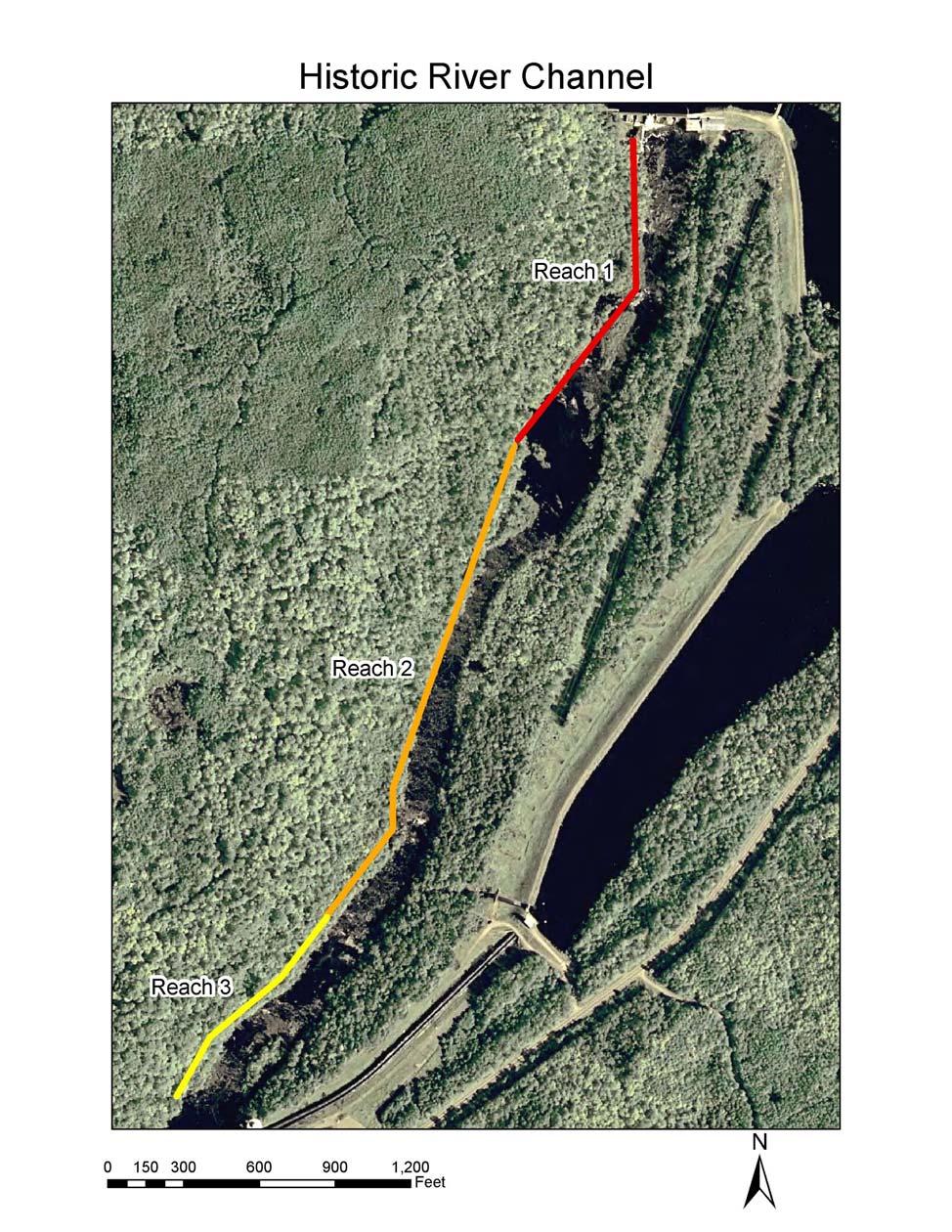
7 Appendix 1 Map Depicting the Historic River Channel Reaches
8 Appendix 2 Boater Evaluation Form for Each Run.
9 Boater Evaluation Form Grandfather Falls Historic River Channel (To Be Completed After Each Run) Boater Information: (boater information other than name only needs to be completed once) Name: Address: Zip Code: Skill Level (check one): o Advanced o Expert o Elite How many years have you boated at your current skill level? years In the past three years, how many days a month do you boat? days How many times have you boated this run before today? times If you boated this run before: What were the flows? cfs What type of watercraft did you use? How far is this river stretch from you home? miles Timing: Date of the Run What was the flow during the run? cfs Watercraft: What type of watercraft did you use for this run? (check one) o hardshell kayak o Inflatable kayak o canoe o other Locations and Times: Put in Location: Take out Location: Time: Time: Difficulty: How would you rate the difficulty (Class I, Class II, etc.) of each Reach? Reach 1? Reach 2? Reach 3? (please see next page)
10 Enjoyment: Are you likely to return for future boating if today s flow was to be provided? (check one) o Definitely No o Possibly o Probably o Definitely Yes Relative to this specific flow release, would you prefer a flow that was higher, lower, or was this optimum? (check one) o Much Lower o Lower o Higher o Much Higher o Optimum Satisfaction: Please respond to each of the following statements about the characteristics at this flow level (please circle one opinion) Statement Strongly Disagree Disagree No Opinion Agree Strongly Agree Reach 1 is boatable at this flow level. Reach 2 is boatable at this flow level. Reach 3 is boatable at this flow level. Reach 1 is safe at this flow level Reach 2 is safe at this flow level Reach 3 is safe at this flow level Overall this is an aesthetically pleasing run Challenges: Please identify particularly challenging rapids or section and rate their difficult at this flow. Please use the International Whitewater Scale and also note if you portaged. Rapid Location (name of Reach) Whitewater Class Portage? (yes or no) (please see next page)
11 Portages: If you used a portage as indicated in the question above, please rate the difficulty at this flow level. Portage Location (name of site) Easy Slightly Difficult Moderately Difficult Extremely Difficult Thank You for your Time and Consideration
12
13 Appendix 3 Boater Evaluation Form for All Runs.
14 Summary Boater Evaluation Form Grandfather Falls Historic River Channel (To Be Completed After All Runs) Boater Information Name: Address: Zip Code: Skill Level (check one): o Advanced o Expert o Elite Flow Levels: Based upon all of your boating trips at various flow levels, please answer the following: What is the lowest flow (in cfs) you need to simply get down the river in your craft? cfs What is the lowest flow that provides quality boating for this reach? cfs What is the optimal range that provides the best whitewater boating for this reach? cfs What do you feel the highest safe flow is for your craft and skill level? Cfs From a recreational perspective, what is the minimum acceptable flow for this run? cfs For you, what is the optimum flow for this run? cfs What is the best or optimal flow for a "standard" trip? cfs What is the best or optimal flow for a "high challenge" trip? cfs What is the highest safe flow for your craft and skill level? cfs If one flow for boating was released, what flow would you prefer? cfs Run Specifics: Please respond to each of the following statements about the characteristics at this flow level (please circle one opinion) Statement Strongly Disagree Disagree No Opinion Agree Strongly Agree This run is a good length The portages on this run are not a problem. The put in for this run is good The take out for this run is good
15 Use of the Run: Are you likely to return for future boating if the optimum flow would be provided? (check one) o Definitely No o Possibly o Probably o Definitely Yes What months would you return to boat? (check one) o Jan o Feb o Mar o Apr o May o Jun o Jul o Aug o Sep o Oct o Nov o Dec Please rate your interest in boating this reach during the winter if the optimum flow was provided. (check one) o Not interested o Slightly interested o Moderately Interested o Very Interested How would you like to receive flow information? (check one) o Telephone Number with Recording o Website Information o Notification Do you believe any of the flows provided today would be suitable for beginning boaters? (check one) o Definitely No o Possibly o Probably o Definitely Yes If so, Which flow Level(s)? Do you believe any of the flows provided today would be suitable for play boating? (check one) o Definitely No o Possibly o Probably o Definitely Yes If so, Which flow Level(s)? Thank You for your Time and Consideration
16 John McConville Pete Steffes Scott Berry Rob Smadge Appendix 4 Preliminary List of Interested Study Participants
Initial Study Report Whitewater Boating
 Initial Study Report Whitewater Boating Prospect No. 3 Hydroelectric Project FERC Project No. P-2337 PacifiCorp May 2015 South Fork of the Rogue River, 2007 Reproduced with permission from Peter Gandesbery,
APPENDIX 2E PHASE II CONTROLLED FLOW SURVEY INSTRUMENTS
 APPENDIX 2E PHASE II CONTROLLED FLOW SURVEY INSTRUMENTS February 2004 PacifiCorp KLAMATH BOATER PRE-FIELDWORK INFORMATION FORM Date: / / 2002 Your name: 1. For the following types of whitewater craft,
UNITED STATES OF AMERICA FEDERAL ENERGY REGULATORY COMMISSION. Morrisville Water & Light FERC No. P-2629 Morrisville Project Green River Development
 UNITED STATES OF AMERICA FEDERAL ENERGY REGULATORY COMMISSION Morrisville Water & Light FERC No. P-2629 Morrisville Project Green River Development AMERICAN WHITEWATER AND VERMONT PADDLERS CLUB MOTION
SACRAMENTO MUNICIPAL UTILITY DISTRICT UPPER AMERICAN RIVER PROJECT (FERC NO. 2101) ICE HOUSE REACH WHITEWATER BOATING FLOW STUDY TECHNICAL REPORT
 ICE HOUSE REACH WHITEWATER BOATING FLOW STUDY TECHNICAL REPORT") SACRAMENTO MUNICIPAL UTILITY DISTRICT UPPER AMERICAN RIVER PROJECT (FERC NO. 2101) ICE HOUSE REACH WHITEWATER BOATING FLOW STUDY TECHNICAL REPORT Devine Tarbell & Associates, Inc. Sacramento, California
SACRAMENTO MUNICIPAL UTILITY DISTRICT UPPER AMERICAN RIVER PROJECT (FERC NO. 2101) ICE HOUSE REACH WHITEWATER BOATING FLOW STUDY TECHNICAL REPORT Devine Tarbell & Associates, Inc. Sacramento, California
Presented to Idaho Washington Aquifer Collaborative February 11, Spokane River Project License
 Presented to Idaho Washington Aquifer Collaborative February 11, 2014 Spokane River Project License Contact Speed Fitzhugh, Spokane River License Manager Telephone - (509) 495-4998 Email - speed.fitzhugh@avistacorp.com
Tuckasegee Paddling Flow Study Results FERC # s 2686, 2698, /20/02
 Tuckasegee River Paddling Recreational Instream Flow Study East Fork, West Fork, and Dillsboro Hydroelectric Projects FERC # s 2698, 2686, 2602 Dillsboro and Whittier Sections - July 2-3, 2001 West Fork
Clackamas River Hydroelectric Project Flows and whitewater recreation: Updated information about Three Lynx and Bob s Hole boating
 Clackamas River Hydroelectric Project Flows and whitewater recreation: Updated information about Three Lynx and Bob s Hole boating Prepared for Portland General Electric 121 SW Salmon Street Portland,
Via . March 31, Whitewater Boating Flow Study Working Group
 Via Email March 31, 2016 TO: Whitewater Boating Flow Study Working Group SUBJECT: Bear Swamp Project (FERC Project No. 2669) Whitewater Boating Flow Study Survey Forms Dear Stakeholder: Bear Swamp Power
Clackamas River Hydroelectric Project Whitewater Kayaking on the Oak Grove Fork
 Clackamas River Hydroelectric Project Whitewater Kayaking on the Oak Grove Fork DRAFT Prepared for Portland General Electric 121 SW Salmon Street Portland, Oregon 97204 Prepared by Doug Whittaker and Bo
APPENDIX 2B PHASE I INTERVIEW FORMAT
 APPENDIX 2B PHASE I INTERVIEW FORMAT February 2004 PacifiCorp The following provides the general format used during Phase I structured interviews. The document outlines the general interview topics and
Three-Year Summary Report. Prospect Whitewater Boating Flow Release. and. Whitewater Boating Access Monitoring Study
 Three-Year Summary Report Prospect Whitewater Boating Flow Release and Whitewater Boating Access Monitoring Study Prospect Nos. 1, 2 and 4 Hydroelectric Project FERC No. P-2630 June 1, 2012 Prepared for
CHAPTER X: PORTAGES AROUND DAMS
 CHAPTER X: PORTAGES AROUND DAMS A. General Description Portages are land routes used by paddlers to transport their boats to and from a launch area or between access sites. Often located along water bodies
Re: Comments on Study Plans and Scoping Document 2 (SD2) for the Black Canyon Hydroelectric Project (FERC P )
 for the Black Canyon Hydroelectric Project (FERC P )") Thomas O Keefe, PhD Pacific Northwest Stewardship Director 3537 NE 87 th St. Seattle, WA 98115 okeefe@americanwhitewater.org Electronic Filing, December 6 th, 2012 Kimberly D. Bose, Secretary Federal Energy
Thomas O Keefe, PhD Pacific Northwest Stewardship Director 3537 NE 87 th St. Seattle, WA 98115 okeefe@americanwhitewater.org Electronic Filing, December 6 th, 2012 Kimberly D. Bose, Secretary Federal Energy
COMPARISON OF FIXED & VARIABLE RATES (25 YEARS) CHARTERED BANK ADMINISTERED INTEREST RATES - PRIME BUSINESS*
 CHARTERED BANK ADMINISTERED INTEREST RATES - PRIME BUSINESS*") COMPARISON OF FIXED & VARIABLE RATES (25 YEARS) Fixed Rates Variable Rates FIXED RATES OF THE PAST 25 YEARS AVERAGE RESIDENTIAL MORTGAGE LENDING RATE - 5 YEAR* (Per cent) Year Jan Feb Mar Apr May Jun Jul
COMPARISON OF FIXED & VARIABLE RATES (25 YEARS) Fixed Rates Variable Rates FIXED RATES OF THE PAST 25 YEARS AVERAGE RESIDENTIAL MORTGAGE LENDING RATE - 5 YEAR* (Per cent) Year Jan Feb Mar Apr May Jun Jul
DESCRIPTION OF THE CHELAN RIVER
 DESCRIPTION OF THE CHELAN RIVER The following information contains excerpts from the Whitewater Boating Feasibility Study conducted on the Chelan River in July, 2000. The Chelan River begins below the
Recreation Resources. Attachment 7.8B. New Bullards Bar Dam Whitewater Study Results
 Recreation Resources Attachment 7.8B New Bullards Bar Dam Whitewater Study Results 1.0 Introduction NEW BULLARDS BAR DAM WHITEWATER BOATING STUDY December 19, 2008 The (YCWA) intends to apply to the Federal
Wisconsin 511 Traveler Information Annual Usage Summary January 3, Wisconsin 511 Phone Usage ( )
") Wisconsin 511 Traveler Information 211 Annual Usage Summary January 3, 212 Overall to-date Summary 36 months of operation 1,16,63 total calls the 1 Million mark was passed on December 3, 212 3,627,527
Wisconsin 511 Traveler Information 211 Annual Usage Summary January 3, 212 Overall to-date Summary 36 months of operation 1,16,63 total calls the 1 Million mark was passed on December 3, 212 3,627,527
TABLE OF CONTENTS LIST OF TABLES NONE LIST OF FIGURES NONE
 TABLE OF CONTENTS 7.4 RIVER-RELATED RECREATION SURVEYS (REC 4)... REC 4-1 7.4.1 Study Objectives... REC 4-1 7.4.2 Study Area... REC 4-1 7.4.3 Methods... REC 4-1 7.4.4 Key Questions... REC 4-3 7.4.5 Results...
7ey. PUBLIC UTILITY DISTRICT NO. I of CHELAN COUNTY P.O. Box 123 VIA ELECTRONIC FILING. 1, Wenatchee, WA (509)
") PUBLIC UTILITY DISTRICT NO. I of CHELAN COUNTY P.O. Box 123 1, Wenatchee, WA 98807-123 (509) 663-8121 1 Toll free 1-888-663-8121 327 N. Wenatchee Ave., Wenatchee, WA 98801 www.chelanpud.org April 29, 2015
PUBLIC UTILITY DISTRICT NO. I of CHELAN COUNTY P.O. Box 123 1, Wenatchee, WA 98807-123 (509) 663-8121 1 Toll free 1-888-663-8121 327 N. Wenatchee Ave., Wenatchee, WA 98801 www.chelanpud.org April 29, 2015
Clackamas River Hydroelectric Project Faraday Diversion Whitewater Boating Study
 Clackamas River Hydroelectric Project Faraday Diversion Whitewater Boating Study FINAL Prepared for Portland General Electric Prepared by Confluence Research and Consulting 6324 Red Tree Circle Anchorage,
SACRAMENTO MUNICIPAL UTILITY DISTRICT UPPER AMERICAN RIVER PROJECT (FERC NO. 2101) CAMINO REACH WHITEWATER BOATING FLOW STUDY TECHNICAL REPORT
 CAMINO REACH WHITEWATER BOATING FLOW STUDY TECHNICAL REPORT") SACRAMENTO MUNICIPAL UTILITY DISTRICT UPPER AMERICAN RIVER PROJECT (FERC NO. 2101) CAMINO REACH WHITEWATER BOATING FLOW STUDY TECHNICAL REPORT Devine Tarbell & Associates, Inc. Sacramento, California Prepared
SACRAMENTO MUNICIPAL UTILITY DISTRICT UPPER AMERICAN RIVER PROJECT (FERC NO. 2101) CAMINO REACH WHITEWATER BOATING FLOW STUDY TECHNICAL REPORT Devine Tarbell & Associates, Inc. Sacramento, California Prepared
2013 Whitewater Survey Results
 If you paddled on If you paddled on Sunday Saturday at flows of 375, at flows of 400, score the score the quality of this quality of this flow for flow for your craft and your craft and skill level. skill
CONCEPTUAL PLANNING REPORT CONCEPTUAL MASTER PLAN WHITEWATER COURSE BARREN RIVER BOWLING GREEN, KENTUCKY
 CONCEPTUAL PLANNING REPORT CONCEPTUAL MASTER PLAN WHITEWATER COURSE BARREN RIVER BOWLING GREEN, KENTUCKY PREPARED BY: RECREATION ENGINEERING AND PLANNING 485 ARAPAHOE AVE. BOULDER, CO 80302 303-545-5883
PROJECT OVERVIEW PROJECT AREA. FAHCE Fish Habitat Restoration Plan EIR
 PROJECT OVERVIEW PROJECT AREA FISH AND AQUATIC HABITAT COLLABORATIVE EFFORT (FAHCE) Fish Habitat Restoration Plan Project Area PROJECT OVERVIEW DOCUMENTS A Settlement Agreement Regarding Water Rights of
TAPOCO PROJECT FERC NO CHEOAH RIVER RECREATION STUDY FINAL REPORT
 TAPOCO PROJECT FERC NO. 2169 Prepared by Kleinschmidt Associates January 2002 TABLE OF CONTENTS EXECUTIVE SUMMARY... 1 1.0 INTRODUCTION... 5 2.0 RIVER CHARACTERIZATION AND CONTROLLED FLOW ASSESSMENT...
LAKE TANEYCOMO ANGLER CREEL SURVEY SUMMARY. Shane Bush Fisheries Management Biologist Missouri Department of Conservation Southwest Region
 LAKE TANEYCOMO 2008-2009 ANGLER CREEL SURVEY SUMMARY Shane Bush Fisheries Management Biologist Missouri Department of Conservation Southwest Region February 1, 2013 Introduction Lake Taneycomo was formed
CONNECTICUT RIVER WATERSHED COUNCIL The River Connects Us
 CONNECTICUT RIVER WATERSHED COUNCIL The River Connects Us Upper Valley: P.O. Box 206, Saxtons River, VT 05154 Electronic Filing UNITED STATES OF AMERICA FEDERAL ENERGY REGULATORY COMMISSION Grafton Hydro,
Lake Taneycomo Fisheries Management. Shane Bush : Fisheries Management Biologist
 Lake Taneycomo Fisheries Management Shane Bush : Fisheries Management Biologist Lake Taneycomo Empire District Electric Company Impoundment Completed in 1913 2,8 acres 22 miles long Lake Taneycomo Table
Yukon River Instream Flow Chinook Salmon Time Series Analysis
 YUKON ENERGY CORPORATION. Yukon River Instream Flow Chinook Salmon Prepared for Yukon Energy Corporation. Normandeau Associates, Inc. December 212 1 AECOM 2251 2nd Avenue 867 633 6474 tel Whitehorse, YT,
2.0 Resource Management Goals of Agencies with Jurisdiction Over the Resource to be Studied
 Yuba River Development Project 1.0 Project Nexus Study 8.2 RECREATION FLOW November 2010 s (YCWA or Licensee) continued operation and maintenance (O&M) of the existing Yuba River Development Project (Project)
Upper Columbia Redband Trout: Conservation for the Future
 Upper Columbia Redband Trout: Conservation for the Future Bryan Jones and Holly McLellan Colville Confederated Tribes Fish and Wildlife Department Historic Notes Upper Columbia River Large runs of steelhead,
Appendix C Bill Cross Rapids Freshwater Mussel and Fishery Study Plan
 Appendix C Bill Cross Rapids Freshwater Mussel and Fishery Study Plan Study Plan Freshwater Mussel and Fishery Study Bill Cross Rapids Grandfather Falls Hydroelectric Project FERC Project No. 1966 March
Interlake Tunnel WRA Board Workshop. August 25, 2014
 Interlake Tunnel WRA Board Workshop August 25, 2014 1 Agenda Introduction Project Description Background Concept of tunnel operations Engineering and analysis performed to date Preliminary modeling results
Packwood Lake Intake Screen Velocity Test Report for Energy Northwest's Packwood Lake Hydroelectric Project FERC No Lewis County, Washington
 for Energy Northwest's Packwood Lake Hydroelectric Project FERC No. 2244 Lewis County, Washington Submitted to P.O. Box 968 Richland, Washington 99352-0968 Submitted by EES Consulting 1155 North State
NEVADA SLOT MACHINES: HISTORICAL HOLD PERCENTAGE VARIATIONS ANNUAL AND MONTHLY HOLD PERCENTAGES, CENTER FOR GAMING RESEARCH, NOVEMBER 2017
 NEVADA SLOT MACHINES: HISTORICAL HOLD PERCENTAGE VARIATIONS ANNUAL AND MONTHLY HOLD PERCENTAGES, 2004-2017 CENTER FOR GAMING RESEARCH, NOVEMBER 2017 Executive Summary Hold percentage the portion of money
Utility Debt Securitization Authority 2013 T/TE Billed Revenues Tracking Report
 Utility Debt Securitization Authority 2013 T/TE Billed Revenues Tracking Report Billing Budgeted Billed Dollar Percent Month Revenues Revenues Variance Variance Jan 2018 11,943,180.68 12,697,662.47 754,481.79
Final Fish Salvage & Temporary Tailrace Barrier Report for the Wallowa Falls Hydroelectric Project Tailrace. (FERC No. P-308) December 18, 2017
 December 18, 2017") Final for the Wallowa Falls Hydroelectric Project Tailrace (FERC No. P-308) December 18, 2017 Prepared by: Jeremiah Doyle PacifiCorp 825 NE Multnomah Street Portland, OR 97232 December 18, 2017 Page 1
Final for the Wallowa Falls Hydroelectric Project Tailrace (FERC No. P-308) December 18, 2017 Prepared by: Jeremiah Doyle PacifiCorp 825 NE Multnomah Street Portland, OR 97232 December 18, 2017 Page 1
APPENDIX C BLUEWAYS ASSESSMENT
 APPENDIX C Blueways Assessment Poor Fork of Cumberland River Section above Kingdom Come State Park and Cumberland, KY By Steve Spencer, Ed.D. Western Kentucky University The author is an American Canoe
Little Spokane River Stream Gage Report: Deadman Creek, Dragoon Creek, and the West Branch of the Little Spokane River
 Little Spokane River Stream Gage Report: Deadman Creek, Dragoon Creek, and the West Branch of the Little Spokane River June 2010 Spokane County Conservation District N. 210 Havana St. Spokane, WA 99202
Canoe Trip # Length of Trip: 225 kilometres Time Required to Complete Trip: 10 to 14 days Number of Portages: 21 to 25
 Canoe Trip #34 34 Brabant Lake - Wapiskau River - Steephill Lake - Reindeer River - Churchill River - Sandy Bay 225 Kilometers - 10 to 14 days - 21 to 25 portages Length of Trip: 225 kilometres Time Required
Eulachon: State of the Science and Science to Policy Forum
 Eulachon: State of the Science and Science to Policy Forum August 27, 2015 Robert Anderson Eulachon Recovery Coordinator National Marine Fisheries Service FCRPS, Dams, and Water Management in the Columbia
3.7 River Navigation Affected Environment
 3 Affected Environment and Environmental Consequences 3.7 River Navigation 3.7.1 Affected Environment Sterling Highway MP 45 60 Project Final EIS The Kenai River is approximately 82 river miles long in
Colorado Avenue Dam Proposed Paddle Trail Improvements Preliminary Design Report Deschutes River, Bend, Oregon
 Colorado Avenue Dam Proposed Paddle Trail Improvements Preliminary Design Report Deschutes River, Bend, Oregon Prepared For: Bend Metro Park and Recreation District 799 SW Colombia Street Bend, Oregon
Final Bull Trout Redd Monitoring Report for the Wallowa Falls Hydroelectric Project
 Final for the Wallowa Falls Hydroelectric Project East Fork Wallowa River barrier to upstream fish migration, photo courtesy of Kendrick Moholt (FERC No. P-308) December 18, 2017 Prepared by: Jeremiah
Albeni Falls Dam Downstream Water Temperature Study Interim Results
 Albeni Falls Dam Downstream Water Temperature Study Interim Results Amy Reese, Chief Water Management Section Seattle District June 24, 2014 US Army Corps of Engineers What we hope to cover today Albeni
Final Fish Salvage & Temporary Tailrace Barrier Report for the Wallowa Falls Hydroelectric Project Tailrace. (FERC No. P-308) December 20, 2018
 December 20, 2018") Final Fish Salvage & Temporary Tailrace Barrier Report for the Wallowa Falls Hydroelectric Project Tailrace (FERC No. P-308) December 20, 2018 Prepared by: Jeremiah Doyle PacifiCorp 825 NE Multnomah Street
Final Fish Salvage & Temporary Tailrace Barrier Report for the Wallowa Falls Hydroelectric Project Tailrace (FERC No. P-308) December 20, 2018 Prepared by: Jeremiah Doyle PacifiCorp 825 NE Multnomah Street
Columbia Lake Dam Removal Project
 Columbia Lake Dam Removal Project The Columbia Lake dam located 1/4 mile upstream of the Paulins Kill River's confluence with the Delaware River in Knowlton Township, Warren County has been proposed for
FINAL Fish Salvage Plan for the Wallowa Falls Hydroelectric Project Tailrace. (FERC No. P-308) April 19, 2017
 April 19, 2017") FINAL for the Wallowa Falls Hydroelectric Project Tailrace (FERC No. P-308) April 19, 2017 Prepared by: Jeremiah Doyle PacifiCorp 825 NE Multnomah Street Portland, OR 97232 April 19, 2017 Page 1 of 10
FINAL for the Wallowa Falls Hydroelectric Project Tailrace (FERC No. P-308) April 19, 2017 Prepared by: Jeremiah Doyle PacifiCorp 825 NE Multnomah Street Portland, OR 97232 April 19, 2017 Page 1 of 10
The effects of mainstem flow, water velocity and spill on salmon and steelhead populations of the Columbia River
 The effects of mainstem flow, water velocity and spill on salmon and steelhead populations of the Columbia River Columbia River Inter Tribal Fish Commission October 12, 2006 Jerry McCann and Margaret Filardo
MINNESOTA DEPARTMENT OF NATURAL RESOURCES DIVISION OF FISHERIES AND WILDLIFE. Gamefish Assessment Report
 Minnesota DNR F-29-R(P) Area F312 February 1, 2013 MINNESOTA DEPARTMENT OF NATURAL RESOURCES DIVISION OF FISHERIES AND WILDLIFE Gamefish Assessment Report Spring Gamefish Assessment on the Mississippi
107 FERC 61,282 UNITED STATES OF AMERICA FEDERAL ENERGY REGULATORY COMMISSION
 107 FERC 61,282 UNITED STATES OF AMERICA FEDERAL ENERGY REGULATORY COMMISSION Before Commissioners: Pat Wood, III, Chairman; Nora Mead Brownell, and Joseph T. Kelliher. Public Utility District No. 1 of
MAR DASHBOARD MAR. Compliant % Breakdown Mar % Late % On-time MAR APR MAY JUN JUL AUG SEP OCT NOV DEC
 Positive Response Compliance 215 Compliant 215 Non-Compliant 216 Compliant 216 Non-Compliant 1% 87% 96% 86% 96% 88% 97% 89% 89% 88% 86% 92% 93% 94% 96% 94% 8% 6% 4% 2% 13% JAN 4% 14% FEB 4% 12% 3% 11%
Progress Report on the Design and Planning of an Infrastructure Improvement Project for the Sunnyside TIF District (Phase II)
") Presentation to the CNRC Board of Directors Regular Meeting March 11, 2015 1 Agenda Preferred Alternate Refinement for University Avenue, 3rd Street, and Beverly Avenue Intersection Improvements validate
Presentation to the CNRC Board of Directors Regular Meeting March 11, 2015 1 Agenda Preferred Alternate Refinement for University Avenue, 3rd Street, and Beverly Avenue Intersection Improvements validate
Yale Reservoir Kokanee (Oncorhynchus nerka) Escapement Report 2016
 Escapement Report 2016") Yale Reservoir Kokanee (Oncorhynchus nerka) Escapement Report 2016 North Fork Lewis River Hydroelectric Project Yale FERC No. 2071 Prepared by: Jeremiah Doyle, PacifiCorp April 4, 2017 1.0 INTRODUCTION
Yale Reservoir Kokanee (Oncorhynchus nerka) Escapement Report 2016 North Fork Lewis River Hydroelectric Project Yale FERC No. 2071 Prepared by: Jeremiah Doyle, PacifiCorp April 4, 2017 1.0 INTRODUCTION
3. EXCEL FORMULAS & TABLES
 Fall 2017 CS130 - Excel Formulas & Tables 1 3. EXCEL FORMULAS & TABLES Fall 2017 Fall 2017 CS130 - Excel Formulas & Tables 2 Cell References Absolute reference - refer to cells by their fixed position.
Conceptual Design Report for the Fabri Dam Modifications Project
 Conceptual Design Report for the Fabri Dam Modifications Project Flint, Michigan Prepared For: City of Flint P.O. Box 99 Flint, MI 48501-0099 Flint River Watershed Coalition 432 N. Saginaw St. Suite 1001
The Economic Importance of Recreational River Use to the City of Calgary
 The Economic Importance of Recreational River Use to the City of Calgary Prepared by: Calgary River Users Alliance May 20, 2016 The Economic Importance of Recreational River Use to the City of Calgary
Fisheries Survey of White Rapids Flowage, Marinette County Wisconsin during Waterbody Identification Code
 Fisheries Survey of White Rapids Flowage, Marinette County Wisconsin during 25 Waterbody Identification Code 6343 Michael Donofrio Fisheries Supervisor Wisconsin Department of Natural Resources Peshtigo,
2018 HR & PAYROLL Deadlines
 th (by payment date) EPAF 3rd PARTY FEEDS WTE Approval 2018 HR & PAYROLL s Normal Payroll day s 2017 B1-26 3 * 13-Dec-17 15-Dec-17 n/a n/a n/a 28-Dec-17 29-Dec-17 11:00 AM 16-Dec-2017 29-Dec-2017 JAN 2018
FOR RELEASE: FRIDAY, MARCH 30 AT 5 AM
 Interviews with 1,014 adult Americans conducted by telephone by ORC International on March 24-25, 2012. The margin of sampling error for results based on the total sample is plus or minus 3 percentage
OPPORTUNITIES & CONSTRAINTS
 OPPORTUNITIES & CONSTRAINTS Grand Rapids Restoration August 2012 We have inherited the past; we can create the future Unknown TABLE OF CONTENTS ES-1 ES-1...... BACKGROUND CONCEPTUAL PLAN ES-2... OPPORTUNITIES
Inlet Specific and Seasonal Variation in Vessel Use Patterns: The case of the Northeast Florida Region
 Inlet Specific and Seasonal Variation in Vessel Use Patterns: The case of the Northeast Florida Region Nancy Montes Robert Swett University of Florida Automatic Identification System (AIS) Ships 300 or
Conceptual Design Report for the Hamilton Dam Modifications Project. Flint, Michigan. Prepared For: City of Flint P.O. Box 99 Flint, MI
 Conceptual Design Report for the Hamilton Dam Modifications Project Flint, Michigan Prepared For: City of Flint P.O. Box 99 Flint, MI 48501-0099 Flint River Watershed Coalition 432 N. Saginaw St. Suite
Fossil Creek Native Fish Repatriation 2009 Implementation Plan Arizona Game and Fish Department
 Fossil Creek Native Fish Repatriation 2009 Implementation Plan Arizona Game and Fish Department MONITORING: Annual monitoring is conducted for each species stocked, typically during late summer or early
Central Oregon Intergovernmental Council
 Central Oregon Intergovernmental Council Regional Transit Master Plan (RTMP) Technical Advisory Committee Kick-Off Meeting May 16, 2012 Meeting Agenda Project Orientation Presentation of Survey Results
CCoWS. Central Coast Watershed Studies. Summary of Precipitation and Streamflow for Potrero and San Clemente Creeks in 2010
 Central Coast Watershed Studies CCoWS Summary of Precipitation and Streamflow for Potrero and San Clemente Creeks in Water-Year 2010 Santa Lucia Preserve Monterey County, California Publication No. WI-2011-01
Specialized Survey Methods for Recreational Reef Fish Fisheries in Florida
 Specialized Survey Methods for Recreational Reef Fish Fisheries in Florida Beverly Sauls, Research Scientist Fish and Wildlife Research Institute Marine Fisheries Research Saint Petersburg, FL Reef Fish
2007 LOWER TUOLUMNE RIVER ANNUAL REPORT
 UNITED STATES OF AMERICA BEFORE THE FEDERAL ENERGY REGULATORY COMMISSION Turlock Irrigation District ) ) and ) Project No. 2299 ) Modesto Irrigation District ) LOWER TUOLUMNE RIVER ANNUAL REPORT Report
Hard Shoulder Running is a valuable tool July 14, Dean H. Gustafson, PE, PTOE State Operations Engineer VDOT Operations Division
 Hard Shoulder Running is a valuable tool July 14, 2016 Dean H. Gustafson, PE, PTOE State Operations Engineer VDOT Operations Division Virginia 2 VDOT s Statewide Operations Program Operations Statistics
Annual Meeting June 17, Research Stewardship Education
 Annual Meeting June 17, 2016 Research Stewardship Education 1 James Chandler, Intern from St. Lawrence University Christina Morrisett, Research Assistant Melissa Muradian, Post-Graduate Research Associate
Order No. 55/18 CENTRA GAS MANITOBA INC.: PRIMARY GAS RATE APPLICATION, EFFECTIVE MAY 1, April 26, 2018
 CENTRA GAS MANITOBA INC.: PRIMARY GAS RATE APPLICATION, EFFECTIVE MAY 1, 2018 BEFORE: Larry Ring, Q.C., Panel Chair Marilyn Kapitany, B.Sc.(Hon), M.Sc., Vice Chair Carol Hainsworth, C.B.A., Member Susan
2017 Lake Winnebago Bottom Trawling Assessment Report
 217 Lake Winnebago Bottom Trawling Assessment Report Adam Nickel, Winnebago System Gamefish Biologist, March 218 There were several highlights from the 217 Lake Winnebago bottom trawling survey, including
WIM #36 MN 36 MP 15.0 LAKE ELMO APRIL 2014 MONTHLY REPORT
 WIM #36 MN 36 MP 15.0 LAKE ELMO APRIL 2014 MONTHLY REPORT In order to understand the vehicle classes and groupings, the MnDOT Vehicle Classification Scheme and the Vehicle Class Groupings for Forecasting
NEVADA DEPARTMENT OF WILDLIFE STATEWIDE FISHERIES MANAGEMENT
 NEVADA DEPARTMENT OF WILDLIFE STATEWIDE FISHERIES MANAGEMENT FEDERAL AID JOB PROGRESS REPORTS F-20-48 2012 RYE PATCH RESERVOIR WESTERN REGION NEVADA DEPARTMENT OF WILDLIFE, FISHERIES DIVISION JOB PROGRESS
Purple Sea Urchin Barrens
 Purple Sea Urchin Barrens Nancy, Cassie and Jessica Pattern Sea Urchins existing in two stable states. Crevices along coastlines feeding on kelp litter that drifts by Emerged from the crevices creating
SACRAMENTO MUNICIPAL UTILITY DISTRICT UPPER AMERICAN RIVER PROJECT (FERC NO. 2101) WHITEWATER BOATING FEASIBILITY TECHNICAL REPORT
 WHITEWATER BOATING FEASIBILITY TECHNICAL REPORT") SACRAMENTO MUNICIPAL UTILITY DISTRICT UPPER AMERICAN RIVER PROJECT (FERC NO. 211) WHITEWATER BOATING FEASIBILITY TECHNICAL REPORT Devine Tarbell & Associates, Inc. Sacramento, California Prepared by: The
SACRAMENTO MUNICIPAL UTILITY DISTRICT UPPER AMERICAN RIVER PROJECT (FERC NO. 211) WHITEWATER BOATING FEASIBILITY TECHNICAL REPORT Devine Tarbell & Associates, Inc. Sacramento, California Prepared by: The
Iowa Department of Natural Resources Iowa Water Trails Grant Program
 Iowa Department of Natural Resources Iowa Water Trails Grant Program Submitted by the City of Story City in conjunction with the Skunk River Paddlers and the Story County Conservation Board Tuesday, January
91 Express Lanes Model Update 2006 State Route 91 Implementation Plan. Gerald V. Nielsten May 18, 2007
 91 Express Lanes Model Update 2006 State Route 91 Implementation Plan Gerald V. Nielsten May 18, 2007 1 Vollmer Associates LLP is now Stantec Inc. Stantec Inc. completed the acquisition of Vollmer Associates
Lower Coquitlam River Project Water Use Plan. Temperature Monitoring Lower Coquitlam River Project Year 2 Report
 Lower Coquitlam River Project Water Use Plan Temperature Monitoring Lower Coquitlam River Project Year 2 Report COQMON#6 Temperature Monitoring Study Lower Coquitlam River Study Period: Year 2-2007 Report
Les Amis de la Rivière Kipawa
 Les Amis de la Rivière Kipawa www.kipawariver.ca 6925 rue Lacroix, Montreal, Quebec H4E 2V4 October 25, 2005 The Hon. Scott Brison Minister of Public Works and Government Services Canada House of Commons
LAKE TANEYCOMO 2011 ANNUAL LAKE REPORT
 LAKE TANEYCOMO 211 ANNUAL LAKE REPORT Shane Bush Fisheries Management Biologist Missouri Department of Conservation Southwest Region March 1, 212 EXECUTIVE SUMMARY Lake Taneycomo was formed by the construction
2016 Annual Work Plan
 Rocky Reach Hydroelectric Project FERC No. 2145 2016 Annual Work Plan 2015 Progress Report d per Rocky Reach Settlement Agreement, Sections 15.1.1 & 15.6.5 Reports provided by Chelan PUD Leads: Ray Heit
Androscoggin River Trail Access Sites. Mahoosucs. 168 miles from its source at Lake Umbagog to Merrymeeting Bay
 Androscoggin River Trail Access Sites Mahoosucs 168 miles from its source at Lake Umbagog to Merrymeeting Bay Trail Under Construction More than 40 Public Access Sites Available Androscoggin River Watershed
3. EXCEL FORMULAS & TABLES
 Winter 2017 CS130 - Excel Formulas & Tables 1 3. EXCEL FORMULAS & TABLES Winter 2017 Winter 2017 CS130 - Excel Formulas & Tables 2 Cell References Absolute reference - refer to cells by their fixed position.
SR 693 (Pasadena Avenue) Corridor Study from Shore Drive South to 66 th Street
 Corridor Study from Shore Drive South to 66 th Street") Welcome and Introduction Sign-in and comment sheets Restrooms and exits Meeting agenda and timeline Meeting goals / expectations Provide input to guide study recommendations Actively participate throughout
Welcome and Introduction Sign-in and comment sheets Restrooms and exits Meeting agenda and timeline Meeting goals / expectations Provide input to guide study recommendations Actively participate throughout
LIFE HISTORY DIVERSITY AND RESILIENCE
 LIFE HISTORY DIVERSITY AND RESILIENCE SPRING CHINOOK IN THE WILLAMETTE RIVER BASIN Kirk Schroeder Brian Cannon Luke Whitman Paul Olmsted Oregon Department of Fish and Wildlife Corvallis Research Lab Thanks
Les Amis de la Rivière Kipawa
 Les Amis de la Rivière Kipawa www.kipawariver.ca 6925 rue Lacroix, Montreal, Quebec H4E 2V4 October 25, 2005 Kim Turnbull Environmental Regulations Officer Office of Greening Government Operations, PWGSC
TESTIMONY OF THOMAS O KEEFE, PhD PACIFIC NORTHWEST STEWARDSHIP DIRECTOR ON BEHALF OF AMERICAN WHITEWATER
 TESTIMONY OF THOMAS O KEEFE, PhD PACIFIC NORTHWEST STEWARDSHIP DIRECTOR ON BEHALF OF AMERICAN WHITEWATER OREGON STATE HOUSE House Committee on Transportation Policy Representative Caddy McKeown, Chair
Canoe Trip # Maps: 63L Amisk Lake 63M Pelican Narrows
 Canoe Trip #51 49 Southeast Arem Deschambault Lake - Pelican Narrows - Wunehikun Bay - Attitti Lake - Belcher Lake - Mukoman Lake - Ohoo Lake - Mukoman River - Sokatisewin Lake - Sandy Bay 170 Kilometers
DEC DASHBOARD. Positive Response Compliance DEC. Compliant Tickets : On-Time Performance Analysis. December % Late.
 Positive Response Compliance 215 Compliant 215 Non-Compliant 216 Compliant 216 Non-Compliant 1% 87% 96% 86% 96% 88% 97% 89% 97% 89% 98% 88% 97% 86% 96% 92% 97% 93% 97% 94% 97% 96% 97% 94% 97% 8% 6% 4%
JAN DASHBOARD. Positive Response Compliance JAN. Compliant Tickets : On-Time Performance Analysis. January % Late.
 Positive Response Compliance 216 Compliant 216 Non-Compliant 217 Compliant 217 Non-Compliant 1% 96% 97% 8% 6% 4% 2% 4% 3% FEB MAR APR MAY JUN JUL AUG SEP OCT NOV DEC 8% Late Compliant Tickets : On-Time
Androscoggin River Trail Access Sites. Mahoosucs. 168 miles from its source at Lake Umbagog to Merrymeeting Bay
 Androscoggin River Trail Access Sites Mahoosucs 168 miles from its source at Lake Umbagog to Merrymeeting Bay Trail Under Construction More than 40 Public Access Sites Available Androscoggin River Watershed
SARASOTA BAY ESTUARY PROGRAM OYSTER HABITAT MONITORING RESULTS: YEAR 1. Jay R. Leverone
 SARASOTA BAY ESTUARY PROGRAM OYSTER HABITAT MONITORING RESULTS: YEAR 1 by Jay R. Leverone Mote Marine Laboratory 1600 Ken Thompson Parkway Sarasota, Fl 34236 to Gary Raulerson Sarasota Bay Estuary Program
Coquitlam/Buntzen Project Water Use Plan
 Coquitlam/Buntzen Project Water Use Plan Temperature Monitoring Lower Coquitlam River Project Year 3 Report Reference: COQMON#6 Study Period: March 2008 April 2009 Report Date: April 2009 Trow Associates
COMMENTS Draft Environmental Impact Statement McCloud Pit Hydroelectric Project (FERC No. 2106) P Applicant: Pacific Gas & Electric Company
 P Applicant: Pacific Gas & Electric Company") COMMENTS Draft Environmental Impact Statement McCloud Pit Hydroelectric Project (FERC No. 2106) P-2106-059 Applicant: Pacific Gas & Electric Company Filed by: FERC Projects Director California Sportfishing
COMMENTS Draft Environmental Impact Statement McCloud Pit Hydroelectric Project (FERC No. 2106) P-2106-059 Applicant: Pacific Gas & Electric Company Filed by: FERC Projects Director California Sportfishing
Riverside Drive Complete Streets Project 3 rd Community Meeting. March 26, 2015
 Riverside Drive Complete Streets Project 3 rd Community Meeting March 26, 2015 Providing Feedback Sign-In with contact information for future updates Complete questionnaire provided tonight Complete comment
Zoning for a Healthy Baltimore
 Zoning for a Healthy Baltimore Results from a Health Impact Assessment of the April 2010 draft zoning code Center for Child and Community Research, Johns Hopkins University in collaboration with the Baltimore
Plan B Dam Breach Assessment
 Plan B Dam Breach Assessment Introduction In support of the Local Sponsor permit applications to the states of Minnesota and North Dakota, a dam breach analysis for the Plan B alignment of the Fargo-Moorhead
WIM #37 I-94, MP OTSEGO, MN APRIL 2012 MONTHLY REPORT
 WIM #37 I-94, MP 200.1 OTSEGO, MN APRIL 2012 MONTHLY REPORT In order to understand the vehicle classes and groupings the Mn/DOT Vehicle Classification Scheme and the Vehicle Classification Groupings for
CUSHMAN RESERVOIRS. Skokomish Watershed Monitoring Conference - Public Meeting Florian Leischner 9/17/2015
 CUSHMAN RESERVOIRS Skokomish Watershed Monitoring Conference - Public Meeting Florian Leischner 9/17/2015 CUSHMAN RESERVOIRS MONITORING Management and monitoring of Tacoma Power reservoirs Lake Cushman