HAWKESBURY-NEPEAN RIVER SYSTEM
|
|
|
- Chrystal Caldwell
- 5 years ago
- Views:
Transcription


1 HAWKESBURY-NEPEAN RIVER SYSTEM Canoe & Kayak Trail Nepean River / Colo River / Hawkesbury River
2 WELCOME Welcome to three canoeing and kayaking opportunities on the Hawkesbury-Nepean River System. The Hawkesbury River has numerous sections and tributaries which are well suited to recreational canoeing and kayaking. It offers spectacular scenery and an abundance of wildlife. Crown and Council Reserves provide places where the public can get access to the river to start or finish your trip. The Hawkesbury-Nepean River System The Hawkesbury River is formed by the confluence of the Grose and Nepean Rivers just north of Penrith in New South Wales. The Grose River rises near Mt Victoria in the Blue Mountains, and the Nepean River near Wollongong some 80 kms south of Sydney. The Nepean River is joined by the Warragamba River south of Penrith. These two rivers together capture much of the water for the city of Sydney and the Sydney Basin. The largest of the dams is Warragamba Dam on the Warragamba River just up stream from its junction with the Nepean. Canoe trails There are three Canoe and Kayak adventures described in this booklet Nepean River Canoe and Kayak Trail (up to 50 kms) Colo River Canoe and Kayak Trail (30 kms) Hawkesbury River Canoe and Kayak Trail (83.5 kms) Each of these trips has its own characteristics and you will be sure to find one that meets your needs. Degree of difficulty Significant falls of rain in the catchments of any of these rivers can change their water quite quickly. The changes are quite short lived however and for most of the time these three canoe trails are slow moving flat water with no rapids, and are quite suited to recreational canoeists with beginner skills. Some degree of endurance will be required on the longer reaches, particularly if a head wind or tide is encountered. The upper reaches of the Colo can be quite shallow after dry spells, but the bottom is sandy and easy to walk towing your canoe. The Hawkesbury River is popular for speed boating and skiing. These activities can create real problems for canoeists and speed boats alike. It is best to canoe the popular areas when speed boating activity is low. It is also advisable to plan canoeing on the Hawkesbury and lower Colo River to coincide with the tide. Canoe and kayak trail maps The canoe trail maps have been prepared by the Land and Property Management Authority to show the public where they can gain ABOUT GPS (Global Positioning System) GPS coordinates have been used to locate critical points along the river. These Coordinates are based on the GDA datum. Your GPS should be set up to Datum Mode: GDA (or WGS), Position: UTM/UPS, Units: Metric, and North Reference: True. The coordinates will only refer to the Zone you are in. You must state the zone if contacting emergency services. The Hawkesbury River Zone is 56. access to the water. With this and the other information provided, you can plan your canoe/kayak trip. Public access to the river is provided by public or Crown reserves. Some of these reserves have public facilities such as toilets and boat ramps. The location of these reserves is shown on the maps but they have also been given a GPS Coordinate so that you can find them from the water. There are numerous riverside caravan parks, tourist parks and ski resorts along the river where you can also get access to the river and obtain accommodation. These are commercial businesses and day use fees may apply. Advice from Maritime Services NSW Maritime is the State Government Authority responsible for marine safety and the regulation of commercial and recreational boating. The following information is supplied for the information of canoeists and kayakers on the Hawkesbury River system. The Hawkesbury River is closed to all boating craft on four occasions each year while aquatic events are held. The times and dates are available on the Maritime Services website, Canoeists should obey basic river rules and travel on the right hand side of the river. To improve visibility to speed boats canoeists should wear bright coloured clothing, and if operating at night should carry a navigation light. When crossing ferry cables always cross behind the ferry not in front of the ferry. Speed boat wash will cause a problem to canoeists. Ensure your splash skirts are in place to avoid swamping, or chose times when speed boats are not operating. Canoeists should wear a PDF (Personal Flotation Device), and consider carrying a V-Sheet (international distress signal) and or a pressure pack air horn to attract attention if you need help. Further information Penrith Valley Visitor Information Centre (Penrith) Ph Sydney Hills Visitor Centre (Dural) Ph Hawkesbury Visitor Information Centre (Windsor) Ph

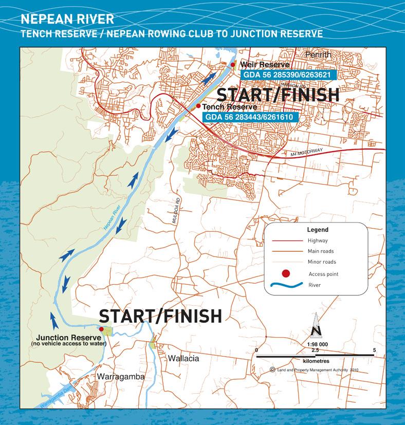
3 HOW NEPEAN TO GET RIVER THERE The waters of the Nepean River are best accessed from riverside reserves at Penrith. However with a bit of effort access to the river can be gained from the reserve at the junction of the Warragamba and Nepean Rivers. Between Penrith and the Junction Reserve is 25kms of spectacular non tidal water that can be paddled in both directions. The wall of the enormous Warragamba Dam is visible just a kilometre or so upstream from the Junction Reserve Degree of difficulty Except after significant rain, the water is flat and non tidal and suited to beginner canoeists. The greatest difficulty will be with wind and the water conditions it causes. Wind speed and direction on the day should be used to determine how far you can travel and return safely. Start/Finish Tench Reserve, Penrith The Tench Reserve is on the eastern bank of the river between the M4 and Penrith. It can be accessed from the M4 via Mulgoa Road and Jamison Road Boat ramp GDA / Public facilities There are toilets, lawns, shade and shelter The reserve is closed at night Not permitted on reserve Available in Penrith Start/Finish Nepean Rowing Club or The Weir Reserve, Penrith The rowing club and weir reserve is on the eastern bank at Penrith just north of the old Great Western Highway bridge over the Nepean for the. From Penrith turn right just before crossing the bridge Rowing Club or natural beach GDA / Public facilities Behind the Nepean Rowing Club is a reserve with toilets, a shelter and car park. The reserve is closed at night Available in Penrith (1 km) Alternate pullout at the boat ramp in the Tench Reserve GDA / Start/Finish Junction Reserve, Wallacia The Junction Reserve is at the end of Nortons Basin Road. This road is accessible off Silverdale Road at Wallacia. The road ends at a car park, and an 800m walk down the fire trail leads to the water Natural, find a spot Approx GDA / Public facilities None Not permitted on reserve Nepean River
4

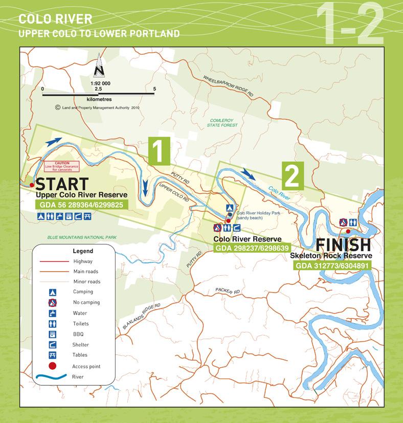
5 HOW COLO TO RIVER GET THERE The lower reaches of the Colo River are tidal and can be paddled in both directions with the tide. However the upper reaches are best travelled with the current ie downstream. The canoe trail is described here as if you were paddling down stream, starting at the Upper Colo Recreation Reserve and finishing at the Skeleton Rocks Reserve at Lower Portland. Degree of difficulty After rain the Colo River can rise quite quickly but normally it is a slow and quite shallow in the upper reaches. The bottom is sandy and there are no rapids. The lower sections are tidal and quite suited to beginner canoeists. It pays however to paddle with the tide. For Hawkesbury Tides see Beaches/Other/Hawkesbury_River_-_Gunderman.html or just Google Hawkesbury tides. Getting to the start The Upper Colo Recreation Reserve can be reached by vehicle from the Putty Road either by taking the Comleroy Road, or the Upper Colo Road. Both have gravel surfaces and are narrow and winding so take care. CAUTION The bridge over the Colo is a low level bridge so if there has been recent rain clearance under the bridge may be reduced. Please check this as you go across. If there is not enough clearance for you and the canoe you should start your trip from below the bridge by launching from the parking area on the northern side. Otherwise proceed to the Upper Colo Reserve where there are excellent facilities. Start Upper Colo Reserve GDA / is permitted (fee payable) Facilities Toilets, drinking water, shelter, barbeques and tables Via Upper Colo Road and Hulberts Road None locally, nearest Kurrajong, Richmond or Windsor Colo River

6 HOW COLO TO RIVER GET THERE UPPER COLO TO COLO 1 2 COLO RIVER COLO TO LOWER PORTLAND Destination Colo Reserve under the Putty Road bridge Distance by river 16 kms Paddling time 5-6 hrs A small ramp just downstream of reserve GDA / Hazards Upper Colo Bridge At a river level of over 1.3m canoeists will have difficulty getting under this low level bridge. Portage around or start from below the bridge. Difficulty At low levels parts of this section can be shallow and you may need to drag your canoe short distances. The river bottom is sandy and this is not difficult. The water is suited to beginners Public facilities Car park, toilets, shelter and lawn Not available on the reserve. Over the river is Colo River Holiday Park with an excellent sandy beach and camping facilities Destination Skeleton Rocks Reserve Distance by river 14 kms Paddling time Approx. 4-5 hrs depending on the tide Difficulty Deep flat tidal water, ideal for beginners but plan the trip to go with the tide Public landing GDA / Public facilities Boat loading ramp, toilets and car park Not permitted Via west Portland Road Wilberforce, Windsor or Wisemans Ferry via the Putty Road Colo River Holiday Park Colo River
7

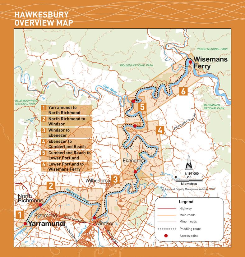
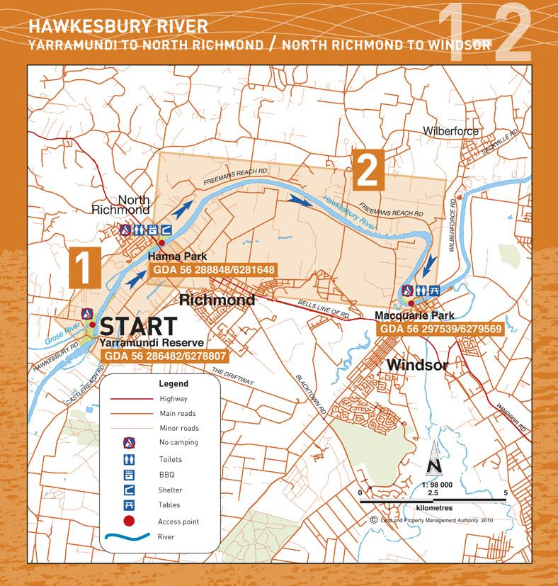
8 HOW HAWKESBURY TO GET THERE RIVER Yarramundi to Wiseman s Ferry This canoe trail can be travelled in any direction, but it is best travelled with the tide. Tide times can be checked on localtime_nsw/sydney_northern_beaches/other/hawkesbury_ River_-_Gunderman.html or just Google Hawkesbury tides For the purposes of this booklet it is be described as travelling downstream. Degree of difficulty Hawkesbury River Canoe and Kayak Trail is rated as flat water. It is suited to beginner canoeists. However the river is tidal and can be affected by wind, both of which can add to the difficulty of paddling. Beware of ski boats The Hawkesbury is the playground for Sydney water skiers and there are times that canoeists should avoid if they want good water, some peace and quiet and a degree of safety. The ski boats are most active during the summer months, particularly the school holidays and weekends. Start Yarramundi Reserve Public Beach access to River GDA / Public facilities Car park, shelters, closed at night Not permitted Via Hawkesbury Road Nearest in Richmond (5.5 kms) Which section to paddle Which section of the river you decide to paddle will depend on many factors. This booklet shows you the public and private access points, and the distances in between to help you plan your trip. Getting a car to the other end is also a consideration so the booklet shows the network of roads along the river. Some of these roads are narrow and winding so take care Getting to the start Yarramundi Reserve is at the junction of the Grose and Nepean Rivers. From Sydney take the Windsor Rd to Windsor and then Richmond, then the Castlereagh Rd to Agnes Banks. Take the Hawkesbury Road across the Nepean and turn into Yarramundi Reserve. From the Blue Mountains take the Hawkesbury Road at Springwood and turn into the Yarramundi Reserve just before crossing the Nepean River. Hawkesbury River
9

10 HOW HAWKESBURY TO GET THERE RIVER YARRAMUNDI TO NORTH RICHMOND 1 2 HAWKESBURY RIVER NORTH RICHMOND TO WINDSOR Destination Hanna Park at North Richmond Distance by river 4.0 kms Paddling time 1-2 hrs Hazards At times there is aquatic weed in this section of the river. Ensure you wear a PDF at all times About 1.5 km from Yarramundi is a rock bar, where the water is shallow. Portage may be necessary to avoid damage Beach and jetty GDA / Public facilities Car park, toilets, shelters, BBQ, lawns Not permitted Via Beaumont Ave In North Richmond (1.0 km) Destination Macquarie Park at Windsor Distance by river 13.5 kms Paddling time 4-5 hrs Hazards At times there is aquatic weed in this section of the river. Ensure you wear a PDF at all times Public beach GDA / Public facilities Toilets, car park, shelter and tables. Not permitted Immediately across bridge on Wilberforce Road Accommodation in Windsor (1.0 km) Meals There is a seafood restaurant at the reserve or meals over the bridge in Windsor Hawkesbury River
11

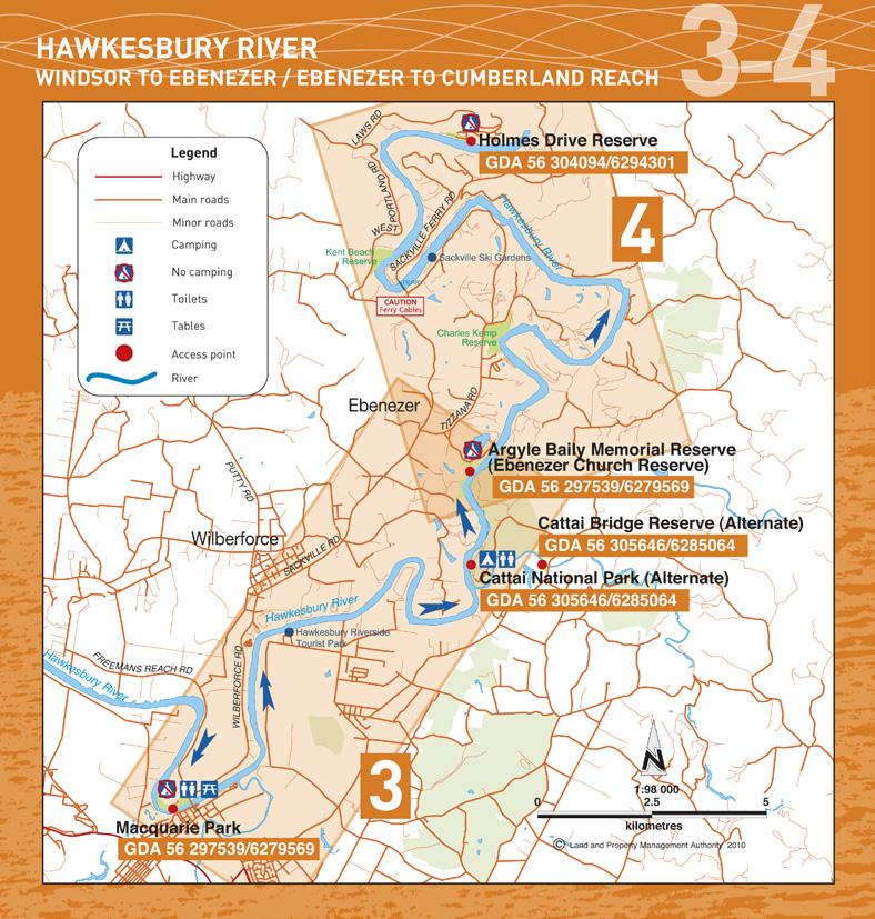
12 3 HOW HAWKESBURY TO GET THERE RIVER WINDSOR TO EBENEZER 4 HAWKESBURY RIVER EBENEZER TO CUMBERLAND REACH Destination Ebenezer Church Reserve Distance by river 15.5 kms Paddling time 4-6 hrs Beach GDA / Facilities Toilets, shelters not permitted Via Tizzana Road and Coromandel Road At Wilberforce and Windsor Alternate landings 1. Cattai National Park, Beach, GDA / Toilets and available please book with NPWS Phone Fees apply 2. Cattai Reserve. On the Cattai Creek where the Cattai Road crosses the Cattai Creek. GDA / Car park, shade, no facilities Destination Holmes Drive Reserve Distance by river 21.5 kms Paddling time 6-7 hrs Hazards Take care crossing the Sackville Ferry cables. Pass behind the ferry when it is moving GDA / Facilities Boat ramp not permitted Via Laws Farm Road and Holmes Drive Wilberforce and Windsor Alternate landings with accommodation and camping 1. Sackville Ski Gardens, Beach, GDA / Phone Hawkesbury Riverside Tourist Park, Beach, GDA / Phone Hawkesbury River
13

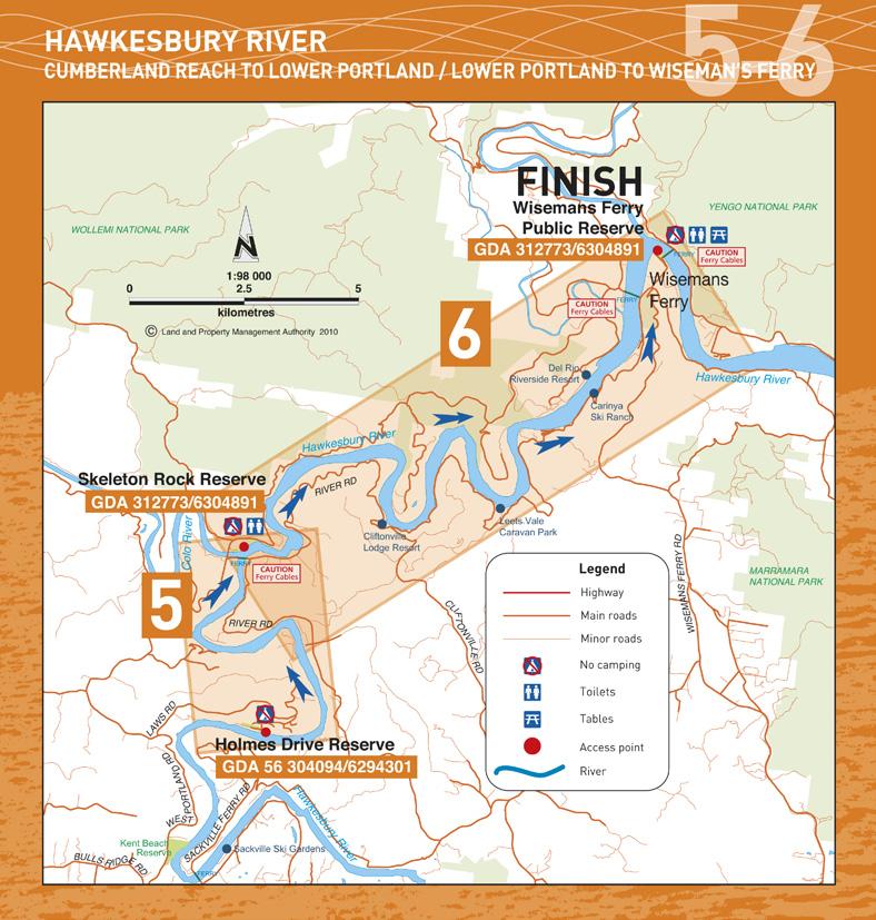
14 5 HOW HAWKESBURY TO GET THERE RIVER CUMBERLAND REACH TO LOWER PORTLAND 6 HAWKESBURY RIVER LOWER PORTLAND TO WISEMAN S FERRY Destination Skeleton Rocks Reserve Distance by river 9 kms Paddling Time 3-4 hrs Hazards Take care crossing the Lower Portland Ferry cables. Pass behind the ferry when it is moving GDA / Facilities Toilet, boat ramp Turn right off the West Portland Road immediately after the bridge over the Colo River not permitted At Wilberforce or Windsor Destination Wisemans Ferry Distance by River 20 kms Paddling Time 6-7 hrs Hazards Take care crossing the Webb s Creek Ferry and Wiseman s Ferry cables. Pass behind the ferry when it is moving GDA / Facilities Toilets, tables, kiosk, beach landing, and shade Turn left into car park just before the ferry Available at Wisemans Ferry Alternate landings with camping and accommodation 1. Clifton Lodge Resort, beach, GDA / Phone Leets Vale Caravan Park, beach, GDA / Phone Carinya Ski Ranch, beach, GDA / Phone Del Rio Riverside Resort, Beach, GDA / Phone Hawkesbury River
15

16 SAFE CANOEING CHECKLIST Before you go Always check the river levels BEFORE your trip. Daily river levels are available on Always let someone know of your trip plans and ensure your support vehicle is aware of your intended rendezvous point and how to get there Canoeists/kayakers should be proficient in moving water. Beginners and children should become competent canoeists/kayakers on still water before attempting moving water GPS coordinates have been supplied to help you locate the reserves. Set up your GPS for the GDA datum and enter the coordinates of the reserves in advance Ensure you have enough fuel, food and water for the trip On the river Make sure you have all your gear when you set off as the river s flow may be too strong to paddle back upstream Avoid travelling alone and stay in contact with other canoes/kayaks in your group Be alert for hazardous overhanging trees and snags If you capsize, hold on to your canoe or kayak until you can beach safely. If the water is freezing leave your craft and head for the bank immediately If in doubt about a rapid or obstacle ahead pull into the bank and check on foot Mobile phone reception is not always reliable along the canoe & kayak trails To avoid overheating, paddle early in the morning or late evening with a break in the hottest part of the day To fish in NSW waters, you must pay a fee and carry the receipt showing payment. For more information visit Safety gear A high visibility Personal Floatation Device - Type 2 with a whistle attached should be worn at all times on the water Hat and sunscreen Map, compass and GPS Spare paddle and repair kit Adequate drinking water and food for 5-8 hrs A first-aid kit and basic knowledge of CPR Waterproof containers for food and warm/dry clothing Appropriate footwear for water and rocks All canoes/kayaks should have fixed buoyancy with securing loops at each end A rope or throw line should be carried for rescue purposes At the campsite Practice low impact camping take out what you take in Do not drink the river water without boiling or treating it. Carry adequate supplies of drinking water with you Light fires in fire places provided and extinguish completely before leaving. Observe any fire bans that are in place Bury your waste at least 50 m from the river if there are no toilets Do not interfere with vegetation, gates, fences or stock Do not use soaps or detergents in the river Respect other canoeists/kayakers and campers Canoe & kayak trail is published by NSW Land and Property Management Authority This booklet is designed as a reference guide only and is not to be used as a teaching aid. Canoeists/kayakers use the trail at their own risk.


17 Land and Property Management Authority Head office 1 Prince Albert Road Queens Square SYDNEY NSW 2000 T F For other great holiday ideas visit Hawkesbury River Images have been selected for marketing and communication purposes only and may or may not be indicative of Crown land. Information is correct at time of printing. February 2010 NSW Land and Property Management Authority (B) P10/06/011
SECTION 11 ADVENTUROUS ACTIVITIES PADDLING: KAYAKING
 SECTION 11 ADVENTUROUS ACTIVITIES 11.18 PADDLING: KAYAKING 11.18.1. ACTIVITY SCOPE This section relates to members participation in Kayaking as a Scouting Activity. A kayak is a small, narrow watercraft
Highland Region MAP. No. 11 St. Marys River No. 12 West River No. 13 Wallace River No. 14 Toney River No. 15 Northumberland Strait
 Highland Region MAP No. 11 St. Marys River No. 12 West River No. 13 Wallace River No. 14 Toney River No. 15 Northumberland Strait 14 Route: No. 11 St. Marys River Rating: Intermediate Advanced Length:
PADDLING THE LOWER STILLAGUAMISH RIVER by Paddle Heaven
 PADDLING THE LOWER STILLAGUAMISH RIVER by Paddle Heaven PUBLISHED BY: Paddle Heaven on Smashwords Paddling the Lower Stillaguamish River Copyright 2010 by Paddle Heaven All rights reserved. Without limiting
International Learn To Swim Programme Water Safety Questions
 International Learn To Swim Programme Water Safety s s for First Step Series s Poolside Safety & Poolside Rules 1. Where is the shallow end of the The answer is specific to the centre. swimming 2. When
Canoe Trip # Length of Trip: 225 kilometres Time Required to Complete Trip: 10 to 14 days Number of Portages: 21 to 25
 Canoe Trip #34 34 Brabant Lake - Wapiskau River - Steephill Lake - Reindeer River - Churchill River - Sandy Bay 225 Kilometers - 10 to 14 days - 21 to 25 portages Length of Trip: 225 kilometres Time Required
General Water Safety Tips
 General Wherever there is water these rules apply. Know the Aquacode Go Together, Stay Afloat and Wave, Reach to Rescue. Always swim with a friend or adult. To reach and rescue, lie down and stretch out.
Canoe Route. Dogtooth Lake-Highwind Lake-Dryberry Lake- Lake of the Woods-Blindfold Lake
 1 Canoe Route Dogtooth Lake-Highwind Lake-Dryberry Lake- Lake of the Woods-Blindfold Lake This is an interesting and challenging route starting and ending at Rushing River Provincial Park. It passes over
Nagambie Waterways Boating Guide 2007
 Nagambie Waterways Boating Guide 2007 Welcome Strathbogie Shire Council has prepared the Nagambie Waterways Boating Guide to help boaters safely enjoy this recreation venue. Funding to assist with the
Nearest Town: Teignmouth Start: From Teignmouth Beach with Car Parking Public car. Finish: Newton Abbot Town Quay Postcode TQ12 4AD - SX
 Teign Estuary Teignmouth Devon Challenging Trail: Please be aware that the grading of this trail was set according to normal water levels and conditions. Weather and water level/conditions can change the
The Albert River - from Lamington National Park down to Moreton Bay
 The Albert River - from Lamington National Park down to Moreton Bay The Lost World the Kerry Road Mt Widgee The right branch of the Albert River rises in Lamington National Park, and runs out of the park
Wattamolla to Big Marley Beach
 Wattamolla to Big Marley Beach 4 hrs 10.4 km Circuit Moderate track 4m This walk is an excellent loop which takes in both the coast and the heathy inland of Royal National Park. Nearly the whole walk has
RIVER TYNE ROWING CLUBS SAFETY CODE
 RIVER TYNE ROWING CLUBS SAFETY CODE Revised 11 June 2010 This safety code is specific to the River Tyne between Redheugh Bridge and Wylam and should be read and operated in conjunction with: British Rowing
Macutagon Creek to Russell s Landing
 Day Trips Macutagon Creek to Russell s Landing Manitouwadge Public Consultation Committee Canoe Route #13 #13 MACUTAGON CREEK TO RUSSELL S LANDING This route is suitable to all levels of paddlers but due
Chapter 7 Canoeing/Kayaking
 Chapter 7 83 84 Canoeing covers a wide and diverse range of disciplines including sea kayaking, white water kayaking, surf kayaking, polo, slalom, marathon, sprint, freestyle and touring. A canoe is a
2017 BRIDGE TO BRIDGE WATER SKI CLASSIC
 2017 BRIDGE TO BRIDGE WATER SKI CLASSIC Sunday 19th November, 2017 Sponsored by SUNDAY BRIEFING This briefing information must be read by all competitors prior to race day. It is the responsibility of
From the President Tony Hystek. In This Issue. President s Message
 Issue 10.5 The May 2010 Edition From the President Tony Hystek ACAS: The Australian Canoeing Award Scheme. In essence it is the range of certification needed to conduct on-water activities or education
Popes Glen, Pulpit Rock, Govetts Leap and Braeside Walk
 Popes Glen, Pulpit Rock, Govetts Leap and Braeside Walk 8 hrs Hard track 13.6 km Circuit 4 1068m This large circuit walk, from Popes Glen to Pulpit Rock, Govetts leap and along the Braeside Track, passes
SUB Vessel Safety Check Review D11NR VE s-we save lives! Prepared by: Mike Lauro DSO-VE 11NR and Tony Budlong ADSO-VE 11NR
 SUB Vessel Safety Check Review D11NR VE s-we save lives! Prepared by: Mike Lauro DSO-VE 11NR and Tony Budlong ADSO-VE 11NR Sport Utility Boats (SUB) The fastest growing area of Recreational Boating! What
Paddle Craft Vessel Safety Check Review D11NR Vessel examiner swe save lives! Prepared by: Mike Lauro DSO-VE 11NR
 1. Paddle Craft Vessel Safety Check Review D11NR Vessel examiner swe save lives! Prepared by: Mike Lauro DSO-VE 11NR Paddle Craft The fastest growing area of Recreational Boating! What s a Paddle Craft?
Fraser Island nd 30 th September 2017
 Fraser Island 2017 The Great Sandy Strait 22 nd 30 th September 2017 An eight day expedition along the southern side of Fraser Island. Alternate trip due to NNW wind forecasts negating the original Hervey
EPA Vessel Safety during Response Operations
 EPA Vessel Safety during Response Operations EPA Vessel Safety Manual EPA employees who operate Class A vessels under 45 feet in length, shall conform to the minimum qualifications; 1) Approval by the
Androscoggin River Trail Access Sites. Mahoosucs. 168 miles from its source at Lake Umbagog to Merrymeeting Bay
 Androscoggin River Trail Access Sites Mahoosucs 168 miles from its source at Lake Umbagog to Merrymeeting Bay Trail Under Construction More than 40 Public Access Sites Available Androscoggin River Watershed
Water. Safety. SeaSOnS Guide for. basic safety guidelines whenever you re in, around or on the water.
 4 Water SeaSOnS Guide for Safety Ontario is blessed with an abundance of picturesque lakes, rivers and Ontario blessed with an abundance picturesque rivers streams. Our is waterways are what makes thisof
Visiting Lake Macquarie
 Visiting Lake Macquarie Lake Macquarie is the largest coastal salt water lake in Australia and is a prime boating destination for both small and large vessels. Many sailing regattas and fishing activities
4 Star Touring Leader Assessment Notes
 4 Star Touring Leader Assessment Notes Technical Syllabus Please note - the provider should use their discretion on elements of the syllabi when due to the craft being paddled, the syllabi request something
SUB Vessel Safety Check Review. Prepared by: Mike Lauro DSO-VE 11NR and Tony Budlong ADSO-VE 11NR
 SUB Vessel Safety Check Review Prepared by: Mike Lauro DSO-VE 11NR and Tony Budlong ADSO-VE 11NR Sport Utility Boats (SUB) The fastest growing area of Recreational Boating! What s an SUB? Canoe, kayak,
Canoe Trip # Maps: 63L Amisk Lake 63M Pelican Narrows
 Canoe Trip #51 49 Southeast Arem Deschambault Lake - Pelican Narrows - Wunehikun Bay - Attitti Lake - Belcher Lake - Mukoman Lake - Ohoo Lake - Mukoman River - Sokatisewin Lake - Sandy Bay 170 Kilometers
Govetts Leap Loop. 1065m. 909m Blue Mountains National Park. 4 hrs 30 mins 8.7 km Circuit. Hard track 380m
 Govetts Leap Loop 4 hrs 30 mins 8.7 km Circuit Hard track 380m This walk, from Blackheath Train Station, is a fantastic way to see some of the iconic areas of the Blue Mountains in the Blackheath area.
THE FIRST MOUNTAIN BIKE TRAIL CENTRE IN THE GCC & MIDDLE EAST
 THE FIRST MOUNTAIN BIKE TRAIL CENTRE IN THE GCC & MIDDLE EAST INTRODUCTION WELCOME TO HATTA TRAIL CENTRE WEBSITE Hatta Trail Centre is a first MTB Centre in the Middle East, and is a home to multiple cross
SELF GUIDED TOURING ROUTE
 SELF GUIDED TOURING ROUTE Things to see and places to go on the loop from Orbost to Marlo, Cape Conran, Cabbage Tree and back to Orbost (or onwards to Cann River) V6 April 2017 This guide should be read
Campbell Drive to Snapper Point
 Campbell Drive to Snapper Point 1 hr 45 mins 4.2 km One way Experienced only 135m This walk follows the Coast Track to Frazer Beach, along the Geebung and (overgrown) Grass Tree Tracks. From the northern
In order to have an enjoyable day out canoeing we need to make some key decisions to ensure we are in the right place at the right time.
 Award Description This award is designed to progress your judgment, decision making and expertise providing an understanding of journeying. As a canoeist you should be confident in planning and undertaking
Launch A: Experimental Lakes Road The launch site is about 4 km from highway #17. There is a sign on the highway indicating the experimental lakes
 Launch A: Experimental Lakes Road The launch site is about 4 km from highway #17. There is a sign on the highway indicating the experimental lakes road. You have to cross railway tracks on the way to the
3 STAR TRIPS & ACTIVITIES
 Lower Tryweryn Weekend trip This is a classic grade 2 section of river from the National Whitewater Centre in Frongoc down to Bala. There is one grade 3 section at the very start and a grade 4 drop at
ROUTE 2. Bateau Channel. Topographic Map 31 C/8 Navigation Charts 1438/39 Reference Maps
 Topographic Map 31 C/8 Navigation Charts 1438/39 Reference Maps ROUTE 2 Bateau Channel The shoreline marshes of the Bateaux Channel team with life. Wetlands provide breeding habitat for amphibians, fish
Androscoggin River Trail Access Sites. Mahoosucs. 168 miles from its source at Lake Umbagog to Merrymeeting Bay
 Androscoggin River Trail Access Sites Mahoosucs 168 miles from its source at Lake Umbagog to Merrymeeting Bay Trail Under Construction More than 40 Public Access Sites Available Androscoggin River Watershed
Scenic World to Echo Point
 Scenic World to Echo Point 1 hr 15 mins 2.1 km One way Moderate track 192m This is one of the most popular tourist walks in the Katoomba area. The walk follows the cliffs along a well maintained and signposted
Katoomba Falls Circuit
 Katoomba Falls Circuit hr 5 mins.5 km Circuit Hard track 59m For those looking for a walk involving more than simple boardwalk, this trail winding through the temperate rain forest could be just the thing.
In the case of capsize, staff to ensure all participants involved are accounted for and safe. ANY NON-PADDLERS MUST STAY AWAY Low High
 RISK ASSESSMENT FOR: Canoeing and Kayaking Reviewed Feb 2018 Written by: Kevin Beattie (Paddlesport Tech Advisor) HAZARD Severity Likelihood LIST OF CONTROL MEASURES OVERALL RESIDUAL RISK RATING (/Med/High)
Axe Vale Canoe Club (AVCC) Risk Register GENERIC RISK ASSESSMENT
 Risk Register GENERIC RISK ASSESSMENT") GENERIC RISK ASSESSMENT Slips, Trips and Falls Drowning Leader to inspect area of operation. under 18 year olds will wear a safety helmet when on the water. Shoes to be worn at all times outside changing
GENERIC RISK ASSESSMENT Slips, Trips and Falls Drowning Leader to inspect area of operation. under 18 year olds will wear a safety helmet when on the water. Shoes to be worn at all times outside changing
BRIEFING CARD: BIG FLYING FOX
 BRIEFING CARD: BIG FLYING FOX Aim: Overcome fears while having fun. Staff instruction & demonstration must be given before use A minimum of 2 supervisors is needed at all times Ensure loop on return rope
NATIONAL MARATHON CHAMPIONSHIPS 2010 INFORMATION AND ENTRY PACK. DATES: Saturday 31st July and Sunday 1st August 2010
 NATIONAL MARATHON CHAMPIONSHIPS 2010 INFORMATION AND ENTRY PACK DATES: Saturday 31st July and Sunday 1st August 2010 HOSTS: WEBSITE: VENUE: Chester Sailing and Canoeing Club www.chestercanoenationals.org.uk
Berowra to Mt Kuring-gai
 Berowra to Mt Kuring-gai 4 hrs 30 mins 9.4 km One way Hard track 4 551m From the ridges above Cowan Creek, this walk takes in some great lookouts (especially around Mt Kuringgai) as well as enjoying an
Ray Lipinski
 Algoma Paddlers 2018 Event List (Updated May 28) There is no charge for trips, but there is a fee for courses, clinics and camps. Participation in club trips requires current club membership. Non-members
In 2015 we paddled from Blue Gums Caravan Park (near Eildon) to Seymour. In 2016 we paddled from Seymour to Shepparton.
 to Seymour. In 2016 we paddled from Seymour to Shepparton.") Goulburn River Shepparton to Moama, 19-24 th November 2017 This was the third leg of the journey down the Goulburn River. In 2015 we paddled from Blue Gums Caravan Park (near Eildon) to Seymour. In 2016
Goulburn River Shepparton to Moama, 19-24 th November 2017 This was the third leg of the journey down the Goulburn River. In 2015 we paddled from Blue Gums Caravan Park (near Eildon) to Seymour. In 2016
Currie Rd to Davidson Park
 Currie Rd to Davidson Park 3 hrs 7.2 km One way Moderate track 28m Starting at Currie Rd in Forestville, this walk follows Middle Harbour to Davidson Park, under Roseville Bridge. There are two optional
Participants Information Guide 2017
 4 TH & 5 TH AUGUST 17 Participants Information Guide 2017 EQUIPMENT CHECKLIST Thanks for your interest in the TRENT100 2017, we have put together the following guide with all the essential information
Whitewater. Scout s Name:
 Whitewater Merit Badge Workbook This workbook can help you but you still need to read the merit badge pamphlet (book). No one can add or subtract from the Boy Scout Requirements #33216. Each Scout must
Waterfall to Heathcote
 Waterfall to Heathcote 5 hrs Hard track 10.8 km One way 4 467m This walk explores the heart of Heathcote National Park, and is easily accessed with a train station at either end. Although relatively close
Chapter 6 Windsurfing and Stand-Up Paddle Boards
 Chapter 6 Windsurfing and Stand-Up Paddle Boards 77 6 78 6.1 Training It is recommended that persons participating in windsurfing and stand-up paddle boarding activities undertake appropriate training.
Hunters Hill to Epping Road
 Hunters Hill to Epping Road 2 hrs 30 mins 5.5 km One way Moderate track 154m An enjoyable walk through lower sections of the Lane Cove National Park, this walk features plenty of mangroves next to the
Kayaks. KCC Standard Operating Procedure. Activity Overview. Be Prepared:
 Kayaks KCC Standard Operating Procedure Activity Overview Across the road from KCC facilities is the pond that we use for Kayaking. We have a selection of 12 sit on kayaks including one double and a triple
Lake Nillahcootie. Recreation Guide
 Lake Nillahcootie Recreation Guide Welcome to Lake Nillahcootie Discover prime fishing, boating and recreation opportunities at Lake Nillahcootie. Lake Nillahcootie is located on the Broken River in north-eastern
GREEN RIVER - FLAMING GORGE
 GREEN RIVER - FLAMING GORGE Rating: Class 3 CFS Range: 800-7,500 Length: 1-2 days Gear: Standard Rafting Gear Maps: Dutch John, UT; Goslin Mountain, UT; Clay Basin, UT; Warren Draw, UT; Swallow Canyon,
Paddle the length of Llyn Tegid (Bala Lake) and back
 and back") Paddle the length of Llyn Tegid (Bala Lake) and back DISTANCE: 7 miles START/FINISH FROM (CIRCULAR ROUTE): Park in the Llyn Tegid Foreshore car park (fees apply), which is just past the leisure centre
Paddle the length of Llyn Tegid (Bala Lake) and back DISTANCE: 7 miles START/FINISH FROM (CIRCULAR ROUTE): Park in the Llyn Tegid Foreshore car park (fees apply), which is just past the leisure centre
Cross Country Skiing in the Tumbler Ridge Area
 Cross Country Skiing in the Tumbler Ridge Area There are numerous locations that are great for cross country skiing in the area surrounding Tumbler Ridge. Some are on trails that have hiking brochures
Accident Report Entrapment Resulting in 1 Fatality Kayak 19 August 2007 Class A
 Accident Report Entrapment Resulting in 1 Fatality Kayak 19 August 2007 Class A Photograph 1 Kayak FINAL REPORT - Maritime New Zealand Investigation Report 2 1. SUMMARY 1.1 A party of four kayakers were
Float Trips CANOEING. Bass River Resort
 Float Trips Bass River Resort 800-392-3700 www.basscanoeresort.com basscanoeresort@misn.com CANOEING Canoeing is delightful on the crystal clear Courtois, Huzzah, and Meramec Rivers. We offer 6, 7, and
*Sandy Point State Park Paddling Routes
 *Sandy Point State Park Paddling Routes *Paddleboards are crazy popular in Anne Arundel County creeks and rivers. The life guards on this park s beaches have paddleboards to use in recusing swimmers. Not
Dubbo Gully and Ten Mile Hollow Circuit (via Clares Bridge)
") Dubbo Gully and Ten Mile Hollow Circuit (via Clares Bridge) 2 Days Hard track 24.3 km Circuit 4 1117m This two day (or ten hour) walk follows several historic roads, now closed to traffic. Starting with
Dubbo Gully and Ten Mile Hollow Circuit (via Clares Bridge) 2 Days Hard track 24.3 km Circuit 4 1117m This two day (or ten hour) walk follows several historic roads, now closed to traffic. Starting with
Pack Rafting The Wangapeka
 Pack Rafting The Wangapeka By Nathan Fa avae PAGE 28 Issue 88 Summer 2018 Pack-rafting is a paddle sport rapidly gaining popularity in New Zealand. I first discovered pack-rafts in 2002, at the Eco Challenge
Rail to River Walk. 3 hrs. Hard track 7.5 km Circuit. 222m
 Rail to River Walk 3 hrs Hard track 7.5 km Circuit 4 222m This walk is a great one from Chatswood Station to the Lane Cove River National Park. The walk descends through the vegetated bushland which fills
Wentworth Falls Conservation Hut Loop
 Wentworth Falls Conservation Hut Loop 3 hrs Hard track 6.7 km Circuit 4 341m This scenic walk from Wentworth Falls Station, winds along the Nature Trail to Conservation Hut, then drops into the magnificent
Upstreampaddle 25.South arm of the Brunswick River, Simpson s Creek drains the freshwater swamp lands of Tyagarah Nature Reserve, 750 hectares. Furthe
 Upstreampaddle 24 The Brunswick River is a shorter length river on the coastal plain of Northern New South Wales. The areas of interest to canoeists are: the reach from the town of Mullumbimby down to
Blackheath Station to Junction Rock Loop (via Grand Canyon and Popes
 Blackheath Station to Junction Rock Loop (via Grand Canyon and Popes 8 hrs 30 mins 18.2 km Circuit Hard track 4 1254m This circuit starts in Blackheath and heads down into the Grand Canyon and Rodriguez
Boating Activity-Specific Plan
 Boating Activity-Specific Plan Camp Name: Prepared By: Phone number: Signature: Date: Enter a date. Title: Email: Complete the following plan for each boating activity that campers participate in. Use
Paddlers and Land Crew Info 2019
 44th Gregory River Canoe Marathon Paddlers and Land Crew Info 2019 All distances to Starting line and Checkpoints are measured from the Gregory Hotel. The Start Line and all Checkpoints will be sign posted
2019 Ord River Marathon
 2019 Ord River Marathon Lake Argyle to Kununurra Sunday 9 th June 2019 The Ord River Marathon is a spectacular 55km marathon paddle down the mighty Ord River from Lake Argyle to Kununurra. Plenty of good
distance Easy/Moderate
 Experience Rating Easy/Moderate distance 40km (25m) Cycling route: 40km (25 miles) Cycling in: The Great Waterway, Prince Edward County Number of days cycling: 1 Recommended number of nights stay: 2 Experience
Halton Physical Education Safety Guidelines Curricular Module; Administrative Procedure Off-Site Activities
 Topic: Effective: September 2008 Cross-Reference: Review/Revision Date: March 2017 Responsibility: Guidelines for Canoeing: Base Camp, Lake Water, Tripping and Moving Water; Kayaking Flat Water; Paddle
Narrows West. Lots For Sale Overview
 Lots For Sale Overview Spring/Summer Sales Book 2017 My family has been living at the Lake Manitoba Narrows for approximately 100 years. One of my grandfathers settled on the west shore of the Narrows
Echo Point to Leura Forest via Three Sisters and Giant Stairs loop
 Echo Point to Leura Forest via Three Sisters and Giant Stairs loop 3 hrs 3.8 km Circuit Hard track 512m This walk starts from the popular Echo Point, in Katoomba, and winds down to the base of the Three
NFCT-Waterway Work Trip Holeb Falls Portage, Moose River, ME Stone Staircase July 5-9, 2017
 NFCT-Waterway Work Trip Holeb Falls Portage, Moose River, ME Stone Staircase July 5-9, 2017 Introduction: The Moose River Bow Trip is a 3 to 4 day paddle that can be completed in a loop by connecting Attean
Water Safety at Strathclyde Park
 Approved by Executive March 2009, Amended December 2011 The provisions contained in the Scottish Rowing Water Safety Code and the Strathclyde Country Park Rules for Avoiding Collisions on Strathclyde Loch
Blackwood Special Schools Outdoor Education Centre Inc. EXPEDITIONS. Duke of Edinburgh Expedition Locations. Duke of Edinburgh Expedition Descriptions
 Blackwood Special Schools Outdoor Education Centre Inc. Wombat State Forest Lerderderg State Forest S Duke of Edinburgh Expedition Locations Duke of Edinburgh Expedition Descriptions Blackwood Special
Health & Safety Plan.
 Bewdley Rowing Club Regatta 2018 Health & Safety Plan. Bewdley Rowing Club2015 Riverside North, Bewdley, Worcestershire, DY12 1AB tel: 01299 402899 Annual Regatta Safety Plan Vehicle and Trailer Access
Nearest Town: Guildford Start and Finish: Riverside Road, Bellfields, Guildford GU1 1LN. Local Facilities: In Guildford
 River Wey and Godalming Navigations- Guildford to Shalford Easy to Moderate Trail: Please be aware that the grading of this trail was set according to normal water levels and conditions. Weather and water
Dead Horse Gap Loop track
 Dead Horse Gap Loop track 4 hrs 30 mins Hard track 9.8 km Circuit 144m 4 This walk starts with a ride up the Kosciuszko Express Chairlift. There is an opportunity to eat at Australia's highest restaurant,
SAFETY PLAN HUNTINGDON GREAT OUSE MARATHON 12 JULY 2015
 SAFETY PLAN HUNTINGDON GREAT OUSE MARATHON 12 JULY 2015 Author: Gary Aldam (Race Organiser) Date: 27 June 2015 1. AUTHORISATION The event is an official Hasler race authorised by the British Canoeing Marathon
EPIC Lakes Swim Coniston
 - Terms and conditions of Entry EPIC Lakes Swim Coniston Welcome to the Epic Lakes Swim Series at Coniston We would like to wish all of you who have entered this event good luck with your final preparations
Whitehorse Canoe Club Guidelines for Trip Coordinators and Trips
 Whitehorse Canoe Club Guidelines for Trip Coordinators and Trips Introduction These guidelines are intended to assist the running of peer trips by Whitehorse Canoe Club members. The Australian Canoeing
Kayak Trip Yeppoon to Stanage Bay (Central Qld coast)
") Kayak Trip Yeppoon to Stanage Bay (Central Qld coast) August 2018. Robin Aurisch. This trip was inspired by a report on the Upstream Paddle site where 5 paddlers did a similar trip back in 2009. To make
Kayak Trip Yeppoon to Stanage Bay (Central Qld coast) August 2018. Robin Aurisch. This trip was inspired by a report on the Upstream Paddle site where 5 paddlers did a similar trip back in 2009. To make
Flatwater Instructor Log Book
 Flatwater Instructor Log Book Name: Canoe South Australia PO Box 281 Port Adelaide SA 5006 (08) 8240 3294 Australian Canoeing PO Box 6805 Silverwater NSW 2128 (02) 8116 9727 Canoe South Australia Flatwater
Entry form available at:
 This document provides the event information as it becomes available. Document status: Date Changes Who 15 th May 2015 Original draft Nick Adnitt 22 nd May 2015 Course map, start/finish, portage diagrams
Floating the Buffalo National River. with First River Outfitter. Michelle Hulett. exp2010_w01h3buffalo2_ann_solution
 Floating the Buffalo National River with First River Outfitter Michelle Hulett The Buffalo River Beginning as just a trickle, The Buffalo National River runs down the Boston Mountains, flows north and
SCHUYLKILL RIVER SOJOURN 2018 GENERAL INFORMATION AND POLICIES
 SCHUYLKILL RIVER SOJOURN 2018 GENERAL INFORMATION AND POLICIES The Schuylkill River Sojourn is a 7-day, 112-mile guided canoe and kayak trip with a wealth of learning opportunities and fun on the Schuylkill
Open Canoe Leader Assessment Notes
 Open Canoe Leader Assessment Notes Technical Syllabus In both open water and moving water environments Canoe Leaders are expected to demonstrate appropriate paddling ability to fulfil their leadership
Traffic Signs and Signals
 CHAPTER FOUR Traffic Signs and Signals Traffic signs control traffic flow, making streets and highways safer for drivers, bicyclists and pedestrians. These signs, which are posted by the Indiana Department
List of Adults participating in the excursion Contact information for children and adults Mobile phone. Risk Control Who When.
 Risk Assessment Date of : Wednesday 23/04/2014 Destination: Baden Powell Scout Centre, Pomona Street, Pennant Hills, NSW, 2120 Departure and arrival times: Leave service 9.00am return to the service 3:30pm
Middle Harbour Creek Loop
 Middle Harbour Creek Loop 5 hrs 45 mins 15.1 km Circuit Experienced only 5 570m This walk explores the upper reaches of Middle Harbour Creek, starting and ending at the great parklands at Davidson Park,
False Creek Rowing Club Head Up The Creek Regatta Regatta Package 2014 Sunday March 9 th, 2014
 Head Up The Creek Regatta Regatta Package 2014 Sunday March 9 th, 2014 Location: Launching from Vanier Park, West of the south end of the Burrard Street Bridge. The course is the False Creek waterway,
Route Summary. Start and Finish Directions. Distance: 7 miles for an out and back trip to St Catherine s Lock Approximate Time: Time 3-5 Hours
 River Wey Guildford to St Catherine s Lock Moderate Trail: Please be aware that the grading of this trail was set according to normal water levels and conditions. Weather and water level/conditions can
Great Tyne Row. Saturday, 20th September Information for Crews
 Saturday, 20th September 2014 Contents 1.0 General Information 1.1 Registration 1.2 Safety Briefing 1.3 Trailers 1.4 Breakfast 1.5 Presentation at Tynemouth 2.0 Rules & Regulations 3.0 Checklist 4.0 Launching
2018 Provincial Girl Events. Let s Go Camping!
 2018 Provincial Girl Events Let s Go Camping! Agenda Welcome Who Are We? What is a Provincial Girl Event? Details on Pathfinder Paddles Murtle Lake 2018 How to Apply Next Steps Questions? Welcome! Many
FRESNO RIVERSPORT CENTER THE PADDLESPORT CAMP
 FRESNO RIVERSPORT CENTER THE PADDLESPORT CAMP The Paddlesport Camp The Paddlesport Camp is not your traditional summer camp. Most of a camper s time will be spent on the water in canoes, kayaks, and standup
Great Tyne Row - 6 September Risk Assessment - last reviewed
 GTR 05 Risk Assessment Great Tyne Row - 6 September 05 - Risk Assessment - last reviewed 6-08-5 Methodology Hazards have been considered based on the nature of the event and expected conditions. Risks
Teralba to Charlestown Park track head
 Teralba to Charlestown Park track head 4 hrs 30 mins 13.3 km One way Moderate track 3 220m This section of the Great North Walk starts from the Teralba train station and winds down and around the edge
Morgans Creek to Padstow
 Morgans Creek to Padstow 2 hrs 45 mins 8 km One way Moderate track 3 144m This pleasant walk starts from the Morgans Creek park, at Henry Lawsons Drive, and follows the Georges River past the Boomerang
Regatta Venue Information
 Regatta Venue Information For PORT DALRYMPLE YACHT CLUB At Beauty Point, Tasmania www.pdyc.yachting.org.au Contents Introduction Background Championship Headquarters Location of Host Club Race Area Maps
I N T R O D U C T I O N
 I N T R O D U C T I O N A B O U T Q U E S T Quest 12 is a one day, individual, unsupported adventure race across Ireland s highest mountains and the toughest cycle routes in the South West, along the Wild