Wild Rivers: Newfoundland and Labrador
|
|
|
- Marjory Richards
- 5 years ago
- Views:
Transcription

1 Indian and Northern Affairs Parks Canada Affaires indiennes et du Nord Parcs Canada Wild Rivers: Newfoundland and Labrador

2 Published by Parks Canada under authority of the Hon. J. Hugh Faulkner, Minister of Indian and Northern Affairs, Ottawa, 1977 QS EE-A1 Les relevés de la série «Les rivières sauvages» sont également publiés en français. Canada Canada metric métrique Metric Commission Canada has granted use of the National Symbol for Metric Conversion.
3 Wild Rivers: Newfoundland and Labrador Wild Rivers Survey Parks Canada ARC Branch Planning Division Ottawa, 1977

4 2 Main River, rapids at Site 4
5 3 It is difficult to find in life any event which so effectually condenses intense nervous sensation into the shortest possible space of time as does the work of shooting, or running an immense rapid. There is no toil, no heart breaking labour about it, but as much coolness, dexterity, and skill as man can throw into the work of hand, eye and head; knowledge of when to strike and how to do it; knowledge of water and rock, and of the one hundred combinations which rock and water can assume for these two things, rock and water, taken in the abstract, fail as completely to convey any idea of their fierce embracings in the throes of a rapid as the fire burning quietly in a drawing-room fireplace fails to convey the idea of a house wrapped and sheeted in flames. Sir William Francis Butler (1872)
6 4 Minister of Supply and Services Canada 1977 Available by mail from Printing and Publishing, Supply and Services Canada, Ottawa, K1A 0S9, or through your bookseller. Catalogue No.: R62-82/ ISBN Price Canada: $1.50 Price other countries: $1.80 Price subject to change without notice. Now available in the Wild River series: Alberta James Bay /Hudson Bay Quebec North Shore Saskatchewan Yukon Territory Soon to be available: Central British Columbia Northwest Mountains The Barrenlands Southwestern Quebec and Eastern Ontario Metric symbols used in this book mm millimetre(s) m metre(s) km kilometre(s) km/h kilometres per hour d - day(s) C degree Celsius
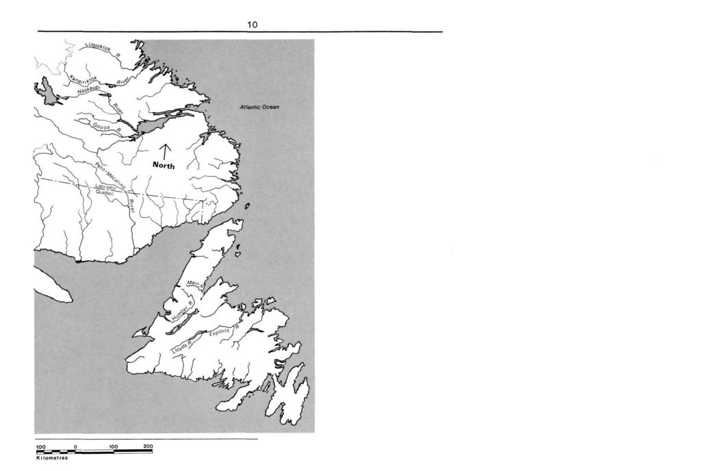
7 5 Table of Contents Foreword 6 Introduction 7 Climate 8 Planning the Trip 9 Map of Newfoundland and Labrador 10 1 Petit Mecantina River 11 5 Goose River 37 6 Humber River 41 7 Lloyds and Exploits Rivers 51 8 Main River 59 Further Reading 64 2 Ugjoktok River 17 3 Kanairiktok River 25 4 Naskaupi River 31
8 6 Foreword Wild rivers are a priceless part of our natural heritage. Untouched by the march of man's technological progress, these waterways are the arteries of our land, and one of the main elements in its growth to nationhood. Long before Europeans laid eyes on them, these rivers served the native peoples as sources of food and means of transportation. Later, the rivers were to carry the Europeans on voyages of exploration and exploitation throughout the vast interior of the continent. The settlers who followed travelled the same routes. The waterways were the mainstay of the fur trade; they were the highways to the gold rushes. They did much to provide the economic nourishment through which Canada grew to its present stature. With the advent of modern technology, some of our rivers were harnessed to serve our newfound needs. But thousands of kilometres of waterways, and the land they pass through, remain essentially untouched. Today, Canadians are gradually rediscovering these fascinating wild rivers. They are recreating the adventures of the explorers; struggling over the same portages as the heavily-burdened "coureurs de bois"; running rapids which once hurtled "voyageurs" and their precious cargoes toward the markets of Montreal; gently floating down majestic rivers which once carried thousands of anxious prospectors towards the promise of gold.
9 7 Introduction Parks Canada is promoting these challenging voyages of discovery, which embrace both the past and the present. However, a good deal of down-toearth information about the rivers and their characteristics is needed before anyone attempts to navigate them. It is for this reason that Parks Canada decided to carry out surveys of wild rivers all across the country. The result is this series of booklets, designed to provide a practical guide for the modern "voyageur". Although "wild" is used to describe rivers not yet harnessed to industry, it is an apt adjective, for many of the rivers should be challenged only by experienced and well-equipped canoeists. The Wild Rivers of Labrador flow across the tip of the Mecantina Plateau, an ancient worn upland. Access is by float plane only, and on a flight to the headwaters one will note rolling spruce-covered hills giving way to string bogs in places. U-shaped valleys indicative of glaciation and sandbars left by fluvial erosion are mixed with occasional and very difficult rapid areas and canyons. Some of the river trips, like the Kanairiktok, have been called uninspiring. Others, for example the wild and free-flowing Petit Mecantina, may demand all the expertise and endurance of an experienced river canoeist. The reward on these rivers is unspoiled wilderness. The Newfoundland rivers are noted for a great variety of landscape and rapid change in river dynamics. The countryside appears as a moor, with rolling rounded mountains and U- shaped valleys carved smooth by ice. Erratics dot the tundra-like vegetation. Some of these rivers have vertical drops of up to 500 m, with formidable obstacles and splendid scenery. Experience is a necessity in meeting these
10 8 Climate challenges. Narrow, swift channels alternate with steady sections. While in some of the more accessible regions logging operations have scarred the slopes and polluted the water, most of the Newfoundland river trips are true wilderness experiences. Labrador The rivers described herein fall within the region of the East Coast Marine Climate. The canoe season is July to September, as ice does not break up in the headwaters until late June. The weather is unpredictable, marked changes in a short period occur frequently. August is the warmest month, with a mean daily maximum and minimum of 14 C and 7 C respectively. The mean rainfall in August is nine centimetres over 16 days of precipitation. In general, climate becomes more moderate at lower elevations. July and September have comparable weather conditions with slightly lower temperatures than August. Insects, a troublesome factor in early summer, disappear in August. Newfoundland For these rivers, one can expect typical maritime climate with considerable precipitation and moderate temperatures. Spring break-up occurs in May. Data taken from Corner Brook and Deer Lake weather stations indicate that June is the coolest of the summer months with mean daily temperatures of 12 C. July is the warmest with a daily mean of 1 6 C. Rainfall may be expected 13 to 15 days per month, with an accumulation of ninety millimetres per month. Local people suggest that, as September is not so cool as June, the fall is a good time to travel.
11 9 Planning the trip In planning a canoe trip, allow 25 to 35 km per day paddling. Always allow extra time and food for such unforeseen events as being windbound or delayed by rain. If egress is to be by plane, make sure arrangements are taken care of before the trip begins. Be sure to check out with some responsible agency (the RCMP or the Department of Natural Resources) stating your route and expected time of arrival. Do not forget to check in with them at the end of the trip. Permits for fires and fishing may be required. Extreme caution should be exercised in the use of fire. Campfires should be built on rock or sand only and extinguished completely. All garbage should be packed out with you. A sturdy canoe capable of handling well in rapids and equipment for its repair are essential. Aluminum canoes were used throughout the surveys and proved very practical. Since lining and hauling are often necessary, several pairs of running shoes or other sturdy footwear that can take the abuse of rocks and constant wetness are needed. In the more isolated regions an emergency survival kit is recommended. The kit should contain high energy food rations, waterproofed matches, fish hooks and line and perhaps emergency signal flares for signalling aircraft. Firearms are never necessary. The National Topographic Series of maps are available from: Canada Map Office, Room 147, 615 Booth Street, OTTAWA, Ontario K1A0E9
12 10
13 11 1 Petit Mecantina River
14 12 Petit Mecantina River Maps required About the river An Aerial Reconnaissance Report (N.T.S. 1: scale) 13 D Lac Brule 13 C Minipi Lake 12 N Natashquan River 12 D St. Augustin 12 J Harrington Harbour The main stem of the Petit Mecantina River originates in southwestern Labrador and flows in a southeasterly direction to the Labrador-Quebec boundary. From here, the river flows in a predominantly southerly direction, emptying into the Gulf of St. Lawrence. The total length of the river system is 392 km and the survey was confined to the river lying between grid points NP 2688/13C and UG 0368/120, a total distance of about 304 km. The river at its source is about 400 m above sea level. The Mecantina originates in a flat string bog area within a very wide and flat valley. The river flows slowly along a meandering course before entering a series of three rapids at NP 2387/13C. The rapids appear navigable but may require some lining. About 1 5 km further downtream there are two rapid
15 13 series of two sets each that can be bypassed with a combination of running, lining and short portages. The river valley here is still quite wide and offers a view of rounded forested mountains. Next is a peaceful, wide section of water occasionally divided by islands. The flat lands immediately adjoining the river are covered with a scrub spruce. The quiet water eventually yields to 11 sets of rapids (over a distance of 10 km). Each rapid set is divided by a steady section of quiet water. Generally, no single set of rapids presents any real difficulty. Each set is passable either by running, lining or portaging along the rocky shoreline. Through all sets the river channel is quite wide and deep, with a large volume of fast-flowing water, where numerous boulders in the channel could impede lining or running. Following the rapid series, the river is characterized by a wide channel with occasional large islands, and a few easy rapid sets. The banks slope gently and are densely forested near the water with spruce and alder growth. The three sets of rapids located at PN 8419/13C can be easily run. Little danger is presented by the boulders in this channel, which is deeply cut through bedrock. The surrounding lands provide good campsites on sandy points and beaches. Below this section the river offers easy paddling to Lac Fourmont, the few minor rapid sections presenting no problem. The river channel widens to 200 m and large bars and silt deposits occur on the shore. Forest fires have burnt the rounded hills that parallel the river. The lake is 22 km long and 2.5 km wide. The southern part of the lake has some excellent campsites on sandy beaches sheltered by low rolling hills. A short channel connects Lac Fourmont and Lac Donquan. This second lake is 10 km in length and has large sand deposits at the downstream end. A broad linking channel in a wide flat valley connects Lac Donquan to Lac Le Breton. The channel features many sand and silt deposits and is easy to canoe. Spruce forests predominate, and the beaches of Lac Le Breton,
16 km long and 1.5 km wide, offer some good camping sites. The lake section just described, however, is rather dull, and canoeing through this area is not a challenge. The elevation of the river at this point is 275 m. Immediately below the outlet of Lac Le Breton is a series 5.5 km long of six sets of rapids, all cutting through bedrock and separated by steady sections of water. The first three sets may be lined, if not run, while the lower three sets probably require short portages over easy terrain. The shoreline of this rapid section consists of steep high banks and hills rising to 150 m on the left with a more gradual slope on the right limit. Below the rapid series the river channel becomes much wider. A few kilometres downstream the river retains its width but the countryside changes to high rolling hills that evidence an old forest fire burn and are partially covered with shrubs and grasses. This wide, steady section of the river is broken by two sets of wide, navigable rapids 16 km downstream at ON 0225/12N. At the terminus of these rapids, the river widens slightly and flows south to southwest for a steady 24 km and is frequently divided by large islands. The valley is generally flat with scrubby spruce growth in patches and more ground cover. Rounded hills in the distance and a forest fire burn become evident further downstream. Generally, the whole river section from Lac Le Breton to the end of this steady section, about 50 km, offers very easy canoeing. The river's elevation at this point is 250 m. From here on the river becomes progressively narrower, and the banks higher and steeper. The hillsides are densely covered with spruce forests, the tops with moss and lichens. Two sets of rapids are encountered, separated by a steady section of water. The river current is very fast, but the channel is almost totally free of boulders and therefore easily navigable. Four kilometres downstream of this point the river narrows to 50 m or less, while the water velocity and turbulence heightens, and the banks rise to 200 m above the water. The topographic chart of St. Augustin,

17 15 Quebec ( 1: ) indicates a series of eight sets of rapids over a distance of about nine kilometres. Beyond this series and up to Cape Mystery (UG 1385/120), a distance of km, only one rapid is indicated on the map sheet. This information is misleading, for most of this distance consists of unnavigable white water. The river banks rise 250 to 300 m above the river, creating a deep V-shaped river-cut canyon. In most sections of this canyon the immediate shoreline consists of very steep and smooth polished bedrock that would be impossible to portage over or use for lining purposes. Petit Mecantina River
18 16 The portage required to bypass this canyon section appears to be equally impossible. It would be necessary to climb 200 to 250 m vertically through very thick spruce forests. Once on the plateau area of the hills, a walk of 19 km over the roughest country imaginable would be necessary to bypass the white water. There is a portage route around the 24 km stretch of white water, used in the past by trappers and Indians who lived in the area. Details of the portage route are unknown but might be uncovered through research. At Cape Mystery, the river bends sharply and flows in a southwesterly direction. In this steady section of about 11 km the river channel becomes wider and the river banks slope more gradually offering the occasional good campsite. Beyond this steady, eight sets of widely-spaced rapids occur over ten kilometres. The longest portage required to bypass any single rapid set would be about one kilometre, while most of the sets could be either run or lined. Beyond this rapid series was the termination point of the aerial reconnaissance. Judging from the topographic maps, the remaining 77 km of the river, until it empties into the Gulf of St. Lawrence, consists of steady water with a wide river channel and gradually sloping river banks. The steady water is broken only twice by waterfalls.

19 17 2 Ugjoktok River
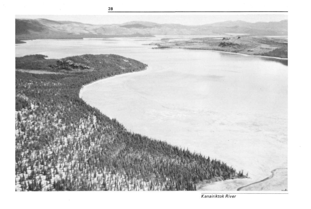
20 18 Ugjoktok River Access and egress Maps required From Grid Réf. N.S to Ugjoktok Bay Length 9 to 12 d (160 km) 14 portages Date of Survey July 28 to August 7, Access to the starting point, (Grid Reference N.S. 2942) is by floatplane, which can be charted at Goose Bay. The termination point of this trip is at the mouth of the Ugjoktok River in Ugjoktok Bay. Egress would also be by floatplane. (N.T.S. 1: scale) 13 M Mistasin Lake 13 N Hopedale
21 19 About the river The canoe trip Geography The Ugjoktok River begins east of the Labrador - Quebec border. From its headwaters in the area around 55 15' N latitude 63 15' W longitude, the river flows eastward within a deeply incised and sparsely vegetated valley. The region around the headwaters is an almost treeless and nearly perfect rock plain, free of all drift save isolated erratics. From these rock plains the Ugjoktok passes into an area of tree-covered hills and sand plains. Near the cost is glacially-moulded hill terrain with few striking features detectable from the river. Flora Spruce generally occupy the steep of the upper river valley increasing in density in a downstream direction. Birch, larch, balsam and poplar willow are predominant along the banks. Fauna Birds sighted were sandpipers, Canada jays, swallows, loons, gulls and terns. Lake trout, salmon, arctic char, and brook trout abound in the lakes and streams of the region. From access to first major rapids: (35 km) At the access point the valley walls are 360 m apart and rise abruptly 200 m to flat barren grounds. The rock walls support some spruce but are generally bare. Alder line the banks and the occasional sand or gravel bar offers good campsites through this first stretch of calm water. The water is clear and affords a view of the cobble, boulder and gravel river bid. The river is lined by the steepsided valley walls. Boulders precariously perched on top of the valley walls together with the narrow and deep river valley lend an awsome beauty to this stretch.
22 20 Rapid Reach, Grid Reference N.S. 7036: As indicated on the topographic maps, the next 22 km of river have a number of rapids and falls. It took two days to complete this demanding section. Much more white water was present than the 1 6 rapids indicated on the maps. Of the four portages made, two were over difficult terrain, while the other two were short and easily managed. The river is quite narrow in many spots along this section, creating fast and turbulent water. Many of the rapids encountered for the first 10 km are unnavigable and lining around them often proved difficult. Ten point five kilometres from the start of the rapids, the first falls are encountered. The half kilometre portage on the north shore is easily made over open bedrock and mosses. The falls and adjoining canyon are particularly beautiful, with separate chutes dropping about six metres in total. Shortly below the falls, another carry is required around one kilometre of canyon. The trail on the right or south shore leads over rugged and terraced bedrock and through alders, ending where a break in the canyon permits a carry down to the water. It is difficult to manoeuvre out of the back-eddy pool here, and care should be taken in the attempt. The remaining short section of canyon, however, is smooth and easily navigated. In the next five kilometres some short stretches necessitate lining or hauling. The second water fall, about three metres in height, requires a 90 m portage over water-sculptured bedrock. After this short portage, some lining is required around a series of step-like drops before entering 1.5 km of navigable water. This is followed by a one kilometre-stretch of canyon containing very fast water. The portage on the south shore involves a 60 m climb over the first 0.5 km with the remainder over rough terrain. From this hillside one has a fine view over the river for several kilometres upstream. If canoe-

23 Ugjoktok River, pool below second portage 21
24 22 ists embark below the fast water, the canyon is navigable to its end. In the rapids that follow, considerable manoeuvring will be necessary to avoid a strong and turbulent current in midchannel. In some cases lining may be required prior to reaching the last set of rapids in this reach, where a large stream enters from the left. Campsites throughout this stretch are difficult to locate. End of Rapid Reach to Harp River (35 km) Below the last rapid there is a marked difference in the river's character. A notable widening of the channel and steep gravel banks mark the beginning of 35 km of easily navigated water that extends to the confluence of the Ugjoktok and Harp Rivers. With the aid of the strong current, this stretch can be covered in four hours. Maintaining incredibly clear water, the river reaches widths approaching 0.5 km. The valley becomes much broader as well, with the banks, although still precipitous, further removed from the river. Near the beginning of this section, a major tributary enters from the right limit at a sharp left bend in the river. Beyond this point the river flows swiftly for 13 km before encountering an island-studded reach that continues almost to the mouth of the Harp River. Harp Lake side trip (25 km) Harp Lake may be reached by a 10 km trip up the Harp River. About half of this distance calls for tracking the canoe upriver. The channel is shallow enough to allow crossing to whichever bank offers the easiest walking. The scene upon entering Harp Lake makes the hours of tracking worthwhile. Near the east end of the lake a rocky peak rises 600 m above the level of the lake, 650 m above sea level. A few kilometres down the lake a sandy beach on the south shore provides a beautiful campsite. The lake is fiord-like, averaging 1.5 km in width over its 50 km length. The return trip down the river took 30 min., compared to 2.5 h to track up.
25 23 Harp River to Shapio River (40 km) Eight kilometres downstream from the mouth of the Harp River, the Ugjoktok flows over a five-metre waterfall. A 180 m portage of bedrock island on the right may be easily made. Immediately below the falls are rapids which may be lined and portaged on the right. Four kilometres downstream, three sets of navigable rapids are encountered. The first and third sets are run through deep water, around boulders and through 50 cm standing waves. The middle rapid has a 50 cm shelf and can be run close to the right bank. Five kilometres of rapids occur downstream. The first two rapids require lining, while the third rapid requires a portage of about a 0.5 km around a chute through a narrowing in the channel. The remaining rapids are first lined along the left and then run close to the right bank, avoiding the heavy water in mid-channel. This calls for careful manoeuvring Below this rapid lies 6.5 km of steady water before another set of rapids occurs, immediately above the mouth of the Shapio River. These rapids can be run with little difficulty. Shapio River to Ugjoktok Bay (30 km) Below the confluence of Shapio River, the Ugjoktok again broadens to a width of 0.5 km and then divides into two channels, the left emptying into Adlatok Bay, the right flowing into Ugjoktok Bay. Above this fork, large sandbars line the river banks. The current is quite slow, flowing at 30 cm/s. Relief is gentle and few striking geographic features are seen from the river. At the fork, the Ugjoktok River is followed in preference to the Adlatok. People familiar with the region warned that the end of the Adlatok presents a very difficult portage over rugged terrain around a 0.5 km long canyon.
26 24 Eleven kilometres below the fork on the Ugjoktok River is an eight-metre waterfall dropping over two distinct steps. Two short portages were required to carry around these falls, the first being an 18 m carry over bedrock, and the second a more difficult 180 m carry through spruce and alder thickets. Both of these portages were made on the south limit. Ugjoktok Bay lies five kilometres downriver from the waterfall. The falls here are of impressively large volume and divided into many channels around a low rock island. Below the falls it is possible to run another 0.5 km through quiet water before coming to the final rapids above Ugjoktok Bay. The run is short but difficult and ends with an 18 m portage past a narrow chute. The open water of the bay is 1.5 km below this rapid. The trip may be terminated here or at the two buildings located at the river-mouth. Since adverse weather conditions along the Labrador coast may restrict flying in the area, it is advisable to carry extra food in case of a delayed pick-up.
27 25 3 Kanairiktok River
28 26 Kanairiktok River Access and egress Maps required An Aerial Reconnaissance Report Access to the headwaters of the Kanairiktok River is restricted to light float-equipped aircraft as there are no roads leading to or running parallel to the river. A convenient starting point would be Shipiskan Lake, although the river further upstream could possibly accommodate the landing of light aircraft. Egress would necessarily be by floatequipped aircraft and could take place in the river itself or in Kanairiktok Bay. The village of Hopedale is situated 72 km northeast from the river mouth; Goose Bay is 272 km south of this point. (N.T.S. 1: scale) 13 L Kasheshibaw Lake 13 K Snegamook Lake 13 N Hopedale
29 27 About the river The Kanairiktok river lies in northern Labrador. From its headwaters near the Quebec border in Ethyl and Morris Lakes, the river flows for 296 km, emptying into Kanairiktok Bay. The total drop in elevation of the surveyed river is 172 m with an average gradient of 1.5 m/km. The survey began 42 km above Shipiskan Lake. At this point the river flows within a well-defined deep and unobstructed channel. The shoreline consists of rounded rocks and the river banks are gently sloping and covered by dense spruce growth to the water's limit. The river valley is U-shaped and ranges from 0.4 to 0.5 km in width. The adjoining lands as viewed from the air are characterized by numerous lakes, string bog areas, and spruce forests. Ground cover seems to be moss and lichen, interrupted by rock outcrops. Shipiskan Lake is oval, 1 5 km long and 2.5 to 4 km wide. The shoreline is regular and composed of rocks and gravel. The right limit is totally burnt whereas the left limit is densely covered with mature black spruce. At the outlet of the lake the river is wide and deep, and has a noticeable current. From Shipiskan Lake to Snegamook Lake is 61 km. The river meanders throughout this stretch with a very slow current past large silt and sand deposits along its banks. The river width varies from 200 m to three kilometres. There are no rapids or falls in this reach, and the river channel at times is divided by large wooded islands and sand bars. Travel between Shipiskan Lake and Snegamook Lake may be monotonous, and head winds may pose a problem to navigation since the low relief affords no protection. Snegamook Lake is 22 km long, 1.5 to 10 km wide, irregularly sloped and sporadically dotted with large islands. Low, rolling, spruce-covered hills girdle the lake. Six point five kilometres below Snegamook Lake, the Kanairiktok is divided by a rock island terminating in a small waterfall. A short and easy portage over exposed bedrock would be required to by-pass this obstacle. Following the fall, the river extends to
30 28 Kanairiktok River
31 29 about 250 m wide and then narrows to 120 m as the first rapid is encountered. Running the rapid may be possible, but if a portage is necessary, it would be over exposed bedrock on either shore. Eight kilometres below the rapids another waterfall is encountered and immediately below is a set of rapids that appears to be quite navigable. Following the falls and rapids there is a section of 13 km of smooth water. Along this section, high and steep fluvial cut banks are quite scenic. The valley is very flat and wide with rolling, forested hills in the distance. This section of river appears very easy to canoe. The latter section leads to a series of four rapids, all divided by steady sections of smooth water. The total length of this unit is about four kilometres. The rapids are all very wide and can be either canoed or lined with little difficulty. The river then runs in a northeasterly direction for about 22 km. The channel is very wide and the river valley seems to have no boundary, creating a somewhat monotonous and uninspiring atmosphere. Ground cover consists primarily of moss, scrub spruce and shrubs, and in the distance, well-defined river terraces can be seen. A minor rapid, which could be bypassed with relative ease is featured. This smooth section ends in a wide waterfall that drops three to four metres. A portage of approximately 0.5 km would be required over the open bedrock of the right shore. About 6.5 km downstream from the falls, a major set of rapids is divided by an island. It would be necessary to portage around this set over very rugged terrain and through dense spruce growth for a distance of 0.5 km. Beyond the rapids, the river channel is still quite wide, the valley very flat and broad, and the adjoining lands scenically unimpressive. Some eight kilometres downstream, the river sharply cuts to the right, encounters a ledge, and drops three
32 metres. By-passing these falls presents no problem, and the small set of rapids below the falls can be navigated. In the next 17 km approaching the coast, the river channel is still very wide and the surrounding environs unexciting. Three sets of rapids are situated here and could be run or lined with ease. Just before the river enters Kanairiktok Bay, two rugged waterfalls are present. The second falls could be by-passed with relative ease. This brings the traveller to the mouth of the river and to the entrance into Kanairiktok Bay. The view of the surrounding rugged scenery is most impressive. Floatplanes can land here to carry travellers to Hopedale or Goose Bay. 30

33 31 4 Naskaupi River
34 32 Naskaupi River Maps required About the river An Aerial Reconnaissance (N.T.S. 1: scale) 13 L Kasheshibaw Lake 13 K Snegamook Lake 13 F Goose Bay The Naskaupi River originates in the interior of the Labrador Plateau and flows in a general easterly direction to empty into Grand Lake in Hamilton Inlet. At one time the river drained Lake Michikamau and surrounding lakes. However, due to the construction of Orma Lake Dyke and the creation of the Smallwood Reservoir in 1971, water flow in the upper Naskaupi was reduced by 90% to a point 35 km downstream of the dyke. The reservoir was created to ensure a minimum volume of water for the new Churchill Falls power development. Even though guarantees were issued to maintain a constant flow of cm 3 /s at the mouth of the Naskaupi from June through September, and to re-create salmon spawning grounds, the river has lost all semblance of its original character.
35 33 From the aerial reconnaissance, it appeared that the upper portion of the river could be hiked by backpackers to a point along the river where the water level is sufficient for canoe travel. Orma Lake Dyke can be reached by a treacherous gravel road that connects Goose Bay to the Churchill Falls dam. A four-wheel drive vehicle is best for travelling this road. Orma Lake to Caribou Lake The creation of the Smallwood Reservoir has diverted the Naskaupi headwaters toward the Churchill Falls Power Project. Orma Lake, the upstream starting point for a trip down the Naskaupi, may be reached by the recently completed gravel road or by floatplane. From the Orma Lake Dyke to Isabella Falls (Kasheshibaw Lake map sheet), the river bed could easily be followed. Isabella Falls at the end of July is a mere trickle. Between Isabella Falls and Maid Marion Falls, the relatively wide open river valley changes in character to gorge topography, varying from 3 to 12m wide and 6 to 15 m deep. The canyon-like terrain terminates below Maid Marion Falls as the river meanders through a flat valley, between the scenic Rainbow Hills and Twin Bluffs, to Caribou Lake. Mud and sand flats are extensive in this reach of the river valley.

36 34 Naskaupi River
37 35 Caribou Lake to Naskaupi Lake There are rapids 16 km below Caribou Lake which low water levels render unnavigable. The scenery changes very little to Wuchusk Lake, except that vegetation is slowly beginning to take a stand on the mud flats. Wuchusk Lake is a landing site for float-equipped aircraft. In the vicinity of "The Narrows", lakes, islands, inlets, and gently rolling hills characterize the region; forest fire damage is evident along the south shore of Seal Lake. Judging from water marks along the shoreline of Seal Lake, water levels at the time of reconnaissance seemed to be approximately three metres below normal. Naskaupi Lake to North West River Settlement Below Naskaupi Lake the first serious white water is encountered as the river runs a course through a boulder-strewn river bed. Short portages and lining may be necessary to bypass some of the rapid sections. Walking is difficult in the immediate vicinity of the river, however, a few hundred metres back of the river, the growth thins out to a lichen-covered landscape as dense black spruce backs a cobbled shoreline through this V-shaped valley. Below North Rapids are interesting rock formations and gorges. Three more rapids occur before Mt. Sawyer, and water levels and canoeing experience would determine whether or not the rapids should be run. The river downstream of Mt. Sawyer appears navigable, although seasonal water levels may determine the difficulty of river travel through this section. Below the mouth of the Red Wine River the Naskaupi widens considerably. Forest cover on the steep banks of Grand Lake is predominantly spruce and birch trees. At times burned over areas and scars left from past logging operations are noticeable. North West River Settlement, at the eastern extremity of Grand Lake, is the terminating point for a trip on the Naskaupi River. A road connects the settlement to Goose Bay.
38 It is obvious that the Naskaupi River is not completely navigable from its headwaters to Grand Lake. A suitable landing spot must be found for float aircraft, and at the same time the existing river conditions could be surveyed. Inclement weather and high winds would be a hazard to any attempt to cross Goose Bay from North West River Settlement; thus a trip should be terminated at North West River. 36

39 37 5 Goose River
40 38 Goose River Access and egress Maps required An Aerial Reconnaissance Date of Survey Low water level Floatplanes may be rented at the dock at Goose Bay. Regularly scheduled aircraft fly in and out of this point. The trip ends at Goose Bay. (N.T.S. 1: scale) 13 E Winokapau Lake 13 F Goose Bay

41 39 About the river The headwaters of the Goose River are a conglomeration of small lakes staggered about the Hamilton Upland, 136 km west of the settlement of Goose Bay. The river flows easterly through more than 1 60 km of the Hamilton and Mecantina Plateaux to empty into Goose Bay on Lake Melville. The only means of access is floatplane; no roads or trails penetrate the region. The river itself cannot accommodate floatplanes, but the numerous lakes in the area provide many possible landing sites. One lake in particular, located at grid reference NQ5583, is large enough to handle the heavily loaded aircraft. From the lake at grid reference NQ5583 to grid reference NQ6529 rapid conditions necessitate much lining and portaging. There is one waterfall 2.5 km from the source. Along this reach of river the landscape is characterized by string bogs and ponds surrounded by meadows of moss and lichens with the occasional patch of spruce and larch. Downstream the river becomes calm and quite easy to canoe down to Goose Falls (grid reference NQ7426). Large steadies are flanked by sandbars which would provide excellent campsites. Water velocity slows above Goose Falls, which drops 40 m, and caution should be exercised when approaching. Little Goose Falls, (grid reference NQ7921 ), is eight kilometres below Goose Falls. At low water they resemble Niagara Falls on a miniature scale, a result of the water flowing over a fault scarp. A portage around the falls along the left limit seems feasible. Downstream of Little Goose Falls, the river bends sharply to the right, the right limit remaining as a sheer cliff face while the left is gradually sloping. At low water, the canyon below the falls seemed navigable but during high water it would probably be impassable. Scouting below the falls regardless of water levels is recommended. The reach of water between Goose Falls and Little Goose Falls is not easy going but far from impassable. Lining, hauling and portaging may be required along a shoreline suitable for such purposes. From the lower falls, Little Goose Falls, to the falls at Grid reference NQ8418, the river bed is strewn with
42 40 huge boulders causing rapids and chutes, quite often impassable and requiring lining and portaging. Below these falls to grid reference PQ2929 the river becomes almost impossible to canoe. Portages throughout this section are at least 0.5 km in length. For these last 27 km the river has been flowing through a V-shaped valley with occasionally vertical walls. The river suddenly widens and the velocity slows considerably. The valley walls remain high and the depth becomes shallow yet navigable as small islands and deltas dot the channel. Approaching the lower end of the river, the channel begins to meander, the current slows considerably, and turbidity increases. Nearing the coast, the last 16 km of river become very turbid and shallow. Extensive sand and clay bars at low flow require cautious selection of a proper channel. Upon entering Goose Bay, a fivekilometre paddle around Groves Point would terminate at the floatplane docks. Caution should be exercised when crossing Goose Bay, for wind storms can cause heavy seas in a matter of minutes.

43 41 6 H umber River
44 42 Humber River Access and egress Maps required Osmond's Pond to Corner Brook Length 13 to 18 d (180 km) 18 portages Date of survey June 23 to July 4, 1972 Access to the headwaters of the Humber River is by floatplane, which may be chartered at Deer Lake. The furthest point upstream on the Humber where a trip may originate is a lake locally Known as Osmond's pond, located at ' N latitude 57 30' W longitude. Although this trip ends at Corner Brook, egress can take place at a number of points upstream which are indicated in the canoe trip section of this report. (N.T.S. 1: scale) 12 A Red Indian Lake 12 H Sandy Lake (N.T.S. 1: scale) 12 H/12E Gros Morne 12 H/11W Silver Mountain 12 H/11E Silver Mountain 12 H/6W Cormach 12 H/6E Cormach 12 H/3W Deer Lake 12 H/4E Pasadena 12 A/13W Corner Brook 12 A/13E Corner Brook
45 43 About the river The canoe trip Geography Located in western Newfoundland, the headwaters of this river originate in the Long Range Mountains and flow southeast down its slopes. Upon reaching Birchy Basin the river veers and flows in a southwest direction parallel to the range, eventually emptying into Humber's Arm at Corner Brook. Over the 180 km the river drops 500 m, most of the drop occurring in the 53 km from the headwater lakes to Birchy Basin. Flora The dominant vegetation in the Humber Valley is spruce and white birch. Away from the river valley in the upper watershead area, open barren lands are a beautiful contrast to dense growth along the river. Thick alders line much of the river bank, adding difficulty to lining or portaging. Further down pitcher plant, kalmia, crackerberry, and rhododendron, lend colour and diversity to the vegetation. Fauna Animal species indigenous to the area are caribou, moose, red fox, beaver and black bear. Bird watchers will spot Canada jays, sparrows, robins, swallows, Canada geese, loons, ducks and kingfishers. The upper 25 km of the Humber accessible by aircraft only, bears little trace of man's influence, and canoeing this section is a superb wilderness experience. However, the section is physically demanding. Water conditions are generally severe and possibly up to half of the 25 km section will require lining or portaging. From Birchy Basin to Deer Lake, a more travelled section, only two short portages, around Big Falls and Little Falls, will be encountered. A few severe rapids present some challenge in the generally smooth flowing river. Canoeists attempting this section should have a good deal of experience with white water canoeing.
46 44 The second section along the river loses something in aesthetics. Most of the left limit of the river has undergone tree harvesting, and the slash from unrestricted cutting not only detracts from the scene but also poses some walking difficulty when portages are required. Deer Lake is a long tedious paddle if conditions are bad. The town of Deer Lake may be considered a point of egress or a stop-over. The Newfoundland Air Transport Base is located on Deer Lake. The scenic, steep valley from Deer Lake to Corner Brook is the most impressive relief experienced on the trip. This section of river is navigable for novice canoeists, with one short stretch of rapids at Shelborn Island. Osmond's Pond to Burnt Hill Pond Osmond's Pond (49 41' N latitude, 57 30' W longitude) is the furthest point upstream with enough water in the channels to allow canoeing. The first stretch of river below Osmond's Pond has a narrow, swift, and steep channel. One point two five kilometres of short ripples soon become heavy rapids, making the channel impassable. The boulder-strewn bed throughout most of the length aids in lining the rapids. Water levels were high at the time of the survey due to a late spring. Generally, at this time of year, water levels would be considerably lower. Osmond Pond East is a narrow water body indented with points, bays and small islands. Vegetation becomes more lush and is characterized by taller trees and less barren land. This lake empties into a difficult section of river which for the first kilometre requires lining with brief carries past very difficult water. After this is a one-kilometre portage on the right around a stretch of unnavigable water flowing over a series of steps and past a steep shoreline. The best route through the broken spruce and tundra vegetation should be scouted. Below the portage, there is a short stretch of steady water which abruptly terminates at an island in a sharp right bend of the river. One channel leads to a three-metre waterfall while the
47 45 other ends in a stretch of turbulent water. After portaging 0.5 km on the left limit it is possible to run and line the remaining short stretch before coming to the mouth of a canyon. The best portage around the canyon was found by walking perpendicular to the river for about 180 m and heading downriver over stunted spruce and open marshland. This difficult 2.5 km section may be lined and canoed in a few sections down to Angus Lake. Angus Lake, the largest of the lake series, offers few campsites. Two thirds of the way down the lake on the right shore, there is a hunting camp which is left open to those who might need temporary shelter. Below Angus Lake a short stretch of river required two portages to the first of a series of small lakes. These are strikingly attractive with small spruce covered islands, open meadow shoreline and snow patches still remaining on the high flanking hills. Short sections of river or narrows between these lakes all have a notable drop in elevation and canoeing is tricky and in some cases impossible. Leaving the fourth small steady, a one-kilometre section of river must be lined down to a two-metre falls. Lining is best done on the right bank as the left has a much denser alder growth near the water's edge. Portaging around the falls brings the traveller to the head of another small pond. Again, below a couple of these ponds are sections of lineable and possibly navigable rapids. Approaching the large lake above Burnt Hill Pond the many islands appear as a maze, with many cross currents and back eddies confusing the easiest route. The outlet of this lake on the east shore is through a one-kilometre rapid which may require lining, and one short portage to Burnt Hill Pond.
48 46 Burnt Hill Pond is essentially the last of the lake series with one more small steady just below it. The small pond below Burnt Hill Pond marks the end of the chain of lakes and the beginning of logging operations. Logging roads make the river accessible at many points. The series of lakes, interspersed by short reaches of river, is the high point of the Humber River trip. Burnt Hill Pond to Birchy Basin The Upper Humber below Burnt Hill Pond is 23 km of rough water emptying into the quiet waters of Birchy Basin. An irregular gradient of 16 m/km along this reach is a good indication of water conditions and canoeing difficulty. Five hundred metres below Burnt Hill Pond is a stretch of unnavigable white water. An 11 km portage follows a logging road on the left limit, and ends below an island in the river channel. Below the island the river is either navigable or lineable around the more hazardous rapids as far as Main Falls (57 08'W;49 35' N). The river at this point is 80 m wide and quite shallow, flowing swiftly over a bed of rounded boulders. Main Falls is located about 1.5 km above the entrance to Birchy Basin and marks the beginning of the canyon that extends throughout this section. A fish ladder allows salmon to by-pass the seven-metre waterfall. For the canoeist, however, the way is not as easy; a rigorous portage through dense alder and balsam fir must be made on the left limit. A portage along the bank in the canyon is nearly impossible as the banks are extremely steep, rising as high as 100 m above the water level and bearing thick vegetation. Tree harvesting operations in the last ten years have left considerable slash on the forest floor which makes walking difficult.

49 47 Humber River, pulp road on portage
50 48 During medium and low water levels a narrow boulder field is exposed on the left bank which may permit lining of the canyon. Birchy Basin starts abruptly below the mouth of the canyon, where the final rapids are navigable into the quiet pool below. This section required almost four days or 20 h of rigorous travel. Birchy Basin to Deer Lake Flattening out markedly below the canyon, the Basin presents a striking and pleasant change. A series of shallow ripples marks the beginning of a slow and deep channel flowing into Birchy Lake. From this point on, the river is posted as a scheduled river for salmon fishing, only licensed fly fishing is permitted. Several inhabited buildings are clustered around Birchy Dam, which is accessible by secondary road and may be considered as an egress or access point for canoeists. A phone is located at the dam site. The first set of rapids above Big Falls appears after 23 km of steady paddling through easy water. These rapids are easily run, but are soon followed by Bear Reef. Here, as the name suggests, a rock reef or shelf extends well into the river and the water flowing swiftly over it poses a danger. Lining is necessary to by-pass this rapid. Two more rapids above Big Falls are navigable but should be scouted, as large standing waves and rugged rock may be hazardous. Big Falls should be approached by very careful lining along the left limit to the edge of the falls. Big Falls is the site of Sir Richard Squires Memorial Park and campsite. Highway 2 provides access to the park. Passage past the Falls involves a 15 m walk. Below Big Falls, one runnable rapid is encountered 1.5 km downstream and another 6.5 km further on, at Little Falls. Highway 2 crosses the river immediately above Little Falls. A trail 15m upstream from the bridge provides a portage route past the falls.
51 49 Another six-kilometre stretch of easy water brings the canoeist to the first of a series of shallow rapids that extend down to Harriman's Steady. These rapids are difficult to approach as bedrock shelves extend across the river. Even at medium water levels it is necessary to walk over many shallow stretches less than 35 cm deep. Low gravel shorelines in this section provide good campsites. Strong winds may at times offer stiff resistance to paddling this wide stretch of river. One point five kilometres below Harriman's Steady is the last series of rapids. The first three of the five rapids are easily navigated while the fourth and the fifth should be scouted prior to running. The channel in the last two rapids is narrow, with a steep gradient and boulder strewn course. Eleven kilometres below the rapids is Deer Lake, where egress may take place at the community of Deer Lake. Deer Lake to Corner Brook Headwinds on Deer Lake may be strong enough to keep canoeists landlocked. With favourable conditions, however, four hours of paddling will cover the 19 km lake to Boom Siding. The shorelines of the lake are strewn with pulp logs, but they present no problems to finding a good campsite. The eastern shore of the lake is closely followed by both the Trans- Canada Highway and the Canadian National Railway. At the end of the lake there will likely be pulp booms, requiring a portage of approximately 1.5 km in length. The easiest route is along the left limit, over roads or the railway line. The trip from Boom Siding to Corner Brook is 19 km of easy water with a small rapid around Shelbron Island. Cottages line much of the right limit of the river. It is in this stretch that the terrain is perhaps more awe inspiring than anywhere else throughout the trip: Near Corner Brook the banks tower 300 m above the water level.
52 From the river mouth, a short run along Humber Arm Inlet brings a canoe party to a convenient egress point above the pulp booms. Earlier egress may be taken eight kilometres upstream at Steady Brook. 50
53 51 7 Lloyds and Exploit River
54 52 Lloyds and Exploit River Access and egress Maps required King George IV Lake to Grand Falls Length 10 to 15 d (198 km) 11 portages Date of survey June 1972 Access to this area is limited to floatplane. King George IV Lake is 80 km south of Corner Brook, Newfoundland's second largest city, and 90 air km from a floatplane base at Pasadena on Deer Lake. A one-hour flight can include reconnaissance of the difficult sections of the Lloyds River. The trip terminates at Grand Falls where road, rail and scheduled air services are available. (N.T.S. 1: scale) 12 A Red Indian Lake 2 D Gander Lake
55 53 About the river The Exploits River system is the largest, and perhaps the most important in Newfoundland. The two main branches of the Exploits, the Lloyds and Victoria Rivers, head in the highlands of the southwest corner of Newfoundland. In contrast to the Victoria River, which has been seriously altered by the construction of the Victoria Lake Dam, the Lloyds River flows through unspoiled wilderness for most of its length. The headwaters lie within 50 km of Newfoundland's west coast, in an area of low relief with barren grounds dotted by small lakes and streams. The Annieopsquotch Mountains parallel the river for about 16 km of this stretch, rising steeply as much as 400 m above the river valley. From Lloyds Lake to the mouth of the river in Red Indian Lake, the Lloyds flows through a narrow steep-sided valley. The effect of recent logging is noticeable in the last few kilometres of the Lloyds River Valley. The Exploits River begins at the outlet of Red Indian Lake, where a dam, built in 1927, regulates its flow. The Exploits Valley is very flat and the river is wide and shallow for most of the distance from Red Indian Lake to Grand Falls. Rapids are infrequent and the gradient is gentle. Flora Vegetation along the Lloyds-Exploits system is predominately a black spruce-white birch association, with frequent bog areas along the Upper Lloyds, and deciduous species such as alder and poplar common along Red Indian Lake and the Exploits River. Eastern white pine and larch occur occasionally in the middle section of the trip. Wildflowers include the pitcher plant, sundew, rhodora, and kalmia. Of these, only the first two species were noticeable in early June. Fauna Common wildlife species include caribou, moose (an introduced species in Newfoundland), black bear, beaver, Canada geese, and several species of ducks. An osprey was observed on the Upper Lloyds River, and seagulls and the occasional tern appeared along the route.
56 54 The canoe trip The Lloyds River offers good fishing in particular for ouananiche a landlocked salmon - and brook trout. Grand Falls has blocked the ascent of Atlantic salmon in the Exploits River, but the Canada Fisheries Service is constructing fishways which will give salmon access to the upper portions of the system. The first part of the system, from King George IV Lake to Lloyds Lake, is recommended for experts only. They should expect to run rapids frequently. The rest of the trip could be undertaken by any canoeists possessing the basic skills required for wilderness canoe travel. King George IV Lake to Lloyds Lake The oulet of King George IV Lake (latitude 48 13' N, longitude 57 53' W) was chosen as a convenient starting point for the reconnaissance trip, since the lake is 10 km 2, large enough to allow floatplane landings. It lies amidst countryside of rather low relief at an elevation of 350 m above sea level. The shores are rocky and irregular and are forested with black spruce, scrubby bushes and bogs. There are a few possible campsites near the outlet. At the outlet, the Lloyds River is about 60 m wide with a fast current, running over cobbles and boulders between low, densely forested banks. Minor rapids begin within 90 m of the outlet, but are navigable for the first 1.5 km then set of in this stretch and there are no good campsites for the next few kilometres. Above the right bank lies a large interesting bog area. The next 6.5 km stretch has several rapids which may require lining. There follows a 1.5 km steady with campsites. Canada geese and a loon were observed in the quiet water. The steady ends in minor rapids followed by a 2.5 m waterfall, (marked as a rapid on the map), which requires

57 55 a short portage. Below the chute is a 180 m canyon which can be run with caution. From here, a brief stretch of easy water precedes an extremely challenging series of rapids with steep rock walls which make lining difficult. One point requires a portage of about 45 m over a hump in the rock wall. Less than 1.5 km below the falls, a 1.25 km portage was required to by-pass a difficult stretch of canyon. A convenient route was found through scrub forest and bogs several hundred metres back from the right bank. The portage ends on a beautiful stretch of river, across from the mouth of a stream which enters on the left bank by a one-metre falls. An island in midriver makes a delightful campsite. The first stretch below the island is easy paddling, with abundant campsites on low grassy banks. About 5.5 km down, the Annieopsquotch Mountains suddenly appear to the east. While the highest peak is only 690 m above sea level, the rise from the river valley, frequently approaching 400 m is very impressive. The mountains are treeless, and the dark brown and grey colours of the rock contrast vividly with occasional snow patches and light green meadows. These mountains are a favourite spot for caribou. Although no rapids are indicated on the map the next few kilometres require some lining, as a combination of frequent boulders and fast shallow water made it totally impossible to canoe. The river averages about 60 m in width in this section. A six-kilometre continuous series of rapids poses the last obstacle before Lloyds Lake, where the mountains tower above the right bank. Eastern white pine appear for the first time on the route. Toward the end of the rapids are excellent campsites on flat, grassy banks. From the end of the rapids to Lloyds Lake, the river is swift and shallow, with no difficult water. One point five kilometres above the lake, the river forms a delta of attractive islands with grassy meadows and birch trees. This is a nesting area for ducks and Canada geese and is excellent moose habitat. Near the lake, the river channels deepen somewhat and offer fishing opportunities. The combination of islands, braided river channel, steep mountains, and the open expanse of Lloyds Lake makes this stretch a particularly attractive one.
58 56 Lloyds Lake to Red Indian Lake The stretch from Lloyds Lake to Red Indian Lake is relaxing by contrast. Lloyds Lake, 122 m above sea level, is about 11 km long and ranges from 1 to 1.5 km wide. The Annieopsquotch Mountains continue halfway down the south side of the lake, and the shores are generally very steep and densely forested. The 6.5 km stretch of the Lloyds River immediately below the lake includes a few minor rapids which are navigable. From here on, the going is easy all the way to Red Indian Lake. The valley sides are rather steep, but the mountains are not very high. River width is about fifty metres. Eleven kilometres further, an eightmetre waterfall flows at the mouth of Otter Brook, on the left bank. From here on, the valley gradually broadens and the river banks become more suitable for camping. A rapid indicated on the map just below Otter Creek does not exist. The river widens in this stretch to about 90 m, and is shallow and quite fast. The litter of an abandoned prospector's camp about 10 km above Red Indian Lake heralds the approach of civilization, and 1.5 km further on, the first signs of logging operations are evident. In the last 1.5 km before Red Indian Lake, the Lloyds River deepens considerably, cutting through steep wooded banks and interesting rock faces. This stretch has remained undisturbed except for a few old cabins, and the logging operations upstream can be temporarily forgotten. Arrival at the mouth of the river brings one back to civilization, for a logging camp on the left bank and a boom across the lake obstruct the view. This is the first possible point of egress, as the logging camp is reached by a dirt road from Buchans. However, use of the road may require permission from the owners, Price Newfoundland Ltd., of Grand Falls. The logging camp is a temporary installation, but it may prove helpful in emergencies. Red Indian Lake Red Indian Lake, 1 50 m above sea level, is the second largest lake in Newfoundland, with a total length of 59 km and a width ranging from 1.5 to 6.5 km. The prevailing southwest winds can produce dangerous water conditions. This hazard is compounded by the

59 57 difficulty of getting off the water when necessary. The shorelines are very densely wooded and occasional gravel beaches are totally clogged with pulp wood. Stopping is extremely difficult and camping virtually impossible. At low water, there might be occasional gravel bars. Topography of the surrounding region is generally flat, and the paddle down the lake can be tedious. Shoreline vegetation is basically spruce, birch and alder, with occasional larch trees. A collection boom just beyond the mouth of Lloyds River blocks the route down the lake and necessitates a portage through dense bush. Both shores seem equally unattractive, but a shorter if unpleasant route was found on the right. From here, there is little to break the monotony of the lake trip. Six point five kilometres west of the outlet of the lake, the Victoria River enters by a falls. The trip down Red Indian Lake ends at Exploits Dam, constructed by the Anglo-Newfoundland Development Company in 1927 as a flow control structure for log driving. The best camping area in the vicinity is a meadow just east of the dam control office on the left bank, however the permission of the dam keeper should be obtained for camping. Bark particles are evident in the water around the dam, but it is potable. Exploits River from Red Indian Lake to Grand Falls Bark fragments and pulp logs along the banks seriously diminish the attractiveness of this portion of the river and scenery along the Exploits is for the most part unspectacular. The surrounding hills are low and the valley quite broad. Forest cover is dense, consisting mainly of spruce and birch, with some larch and alder. Starting from Exploits Dam, the first few kilometres of river have fast but easy water, with low banks showing considerable logging disturbance. About eight kilometres below the dam, a series of rapids requires short stretches of lining which are complicated by log jams on the shoreline. A long smooth stretch follows, in which the river averages 60 m in width. Occasional logging roads end at dumping sites on the river. The confluence of Noel Paul's Brook offers one of the few landmarks in this rather dull stretch. The forest along the banks is dense and campsites are infrequent. Thirty kilometres below Exploits Dam is a series of rapids which ends in a spectacular cascade (not indicated

60 58 on map) known as Red Indian Rattle. These rapids should be approached with caution, as the falls are not obvious from a distance. The first rapid can be run with care, but the Rattle itself is impassable and requires a portage of about 90 m over exposed bedrock. A convenient approach and portage can be made on the right side. The total drop of the falls is about six metres involving a series of steps with a length of about 180 m and a width of 54 m. The Rattle ends in a long pool about 0.5 km across. The 16 km stretch from Red Indian Rattle to the town of Badger, where Highway 50 joins the Trans-Canada, is easy shallow water with a strong current. The forest is dense and without good campsites. The first two sets of rapids indicated on the map below Badger are navigable, but the series about 6.5 km below the town requires a 30 m portage on the left over bedrock to avoid an impassable chute. Some lining, again complicated by log jams on the banks, may be necessary above the chute. From this point on, the river broadens and the current is fast but easy. There are extensive areas of shoals, which are indicated on the map. From a point 19 km below Exploits Dam to Grand Falls, the river is paralleled by Highway 50 and later the Trans- Canada Highway. Six point five kilometres above Grand Falls, a log boom blocks the river, but it may be possible to find a passage between piles. Below the boom, the river bottom is heavily littered with submerged logs. About three kilometres above Grand Falls is an impassable step in the river (indicated as a rapid on map). This should be approached with caution, as the pool above is deceptively serene. Log jams make lining or portaging difficult and dangerous, and since a dirt road from Grand Falls reaches the left bank of the river at this point, it is a convenient place to finish the trip. The road runs about four kilometres to the Trans-Canada Highway on the outskirts of the town, touching the river at several points. Three kilometres further down is another fall of about one metre. A portage would be required to by-pass it, and the trip would then end in the pool of the Price Newfoundland mill. It is recommended that a canoe trip be terminated at the step three kilometres above Grand Falls.
61 59 8 Main River
62 60 Main River Access and egress Maps required Four Ponds to Sop's Arm Length 5 to 8 d (50 km) 4 portages Date of survey July 12 to 17, 1972 Access to the headwaters of the Main River is limited to floatplane, which can be chartered at Deer Lake, 77 km due south of Four Ponds Lake. The best landing site is on the lake locally known as Four Ponds, located at 57 20' W longitude and 49 54' N latitude. A stream less than three kilometres long, empties this series of lakes into the Main River. The trip terminates at the community of Sop's Arm near the mouth of the Main River. (N.T.S. 1: scale) 12 H Sandy Lake 12 H/14 W Main River 12 H/14E Main River 12 H/11 E Silver Mountain, White Bay South District 12 H/15W Jackson's Arm White Bay South District
63 61 About the trip Geography In the 50 km of this river trip, the Main drops from an elevation of 400 m to sea level at a rate of 65 m/km. Frequent and long rapids will be encountered, so persons canoeing this river should be familiar with white water techniques. A feature of this trip is the diversity of river and channel characteristics and of landforms. Open meadows, marshlands, lakes, swift rivers and rounded barren hills together create an enjoyable wilderness experience. Flora A variety of plants and flowers grow in open grass meadows. They include rhodora, crackerberry, purple iris, violets and pitcher plant. The mountain tops are treeless and are covered primarily with moss and lichen. Along the lower slopes grow mature stands of black spruce and, in lesser numbers, birch and larch. Alder and willow are common along the river and in the lowlying areas. Fauna Moose can be seen browsing near the river and although caribou were not sighted during reconnaissance, they are common to the area. Speckled- or brook-trout inhabit the clear cold lakes and rivers. Atlantic salmon also make their annual migration from the sea to spawn in the headwaters of the Main River. The surrounding lakes and calm sections of the river are prime nesting grounds for Canada geese and various other waterfowl.

64 62 The canoe trip The Main River is situated in the southern portion of the Great Northern Penninsula of Newfoundland. From its headwaters on the east slope of the Long Range Mountains the river flows east, emptying into Sop's Arm of White Bay. The actual divide is far from mountainous as glaciation has rounded the peaks and in many cases erratics have been left on the barren hilltops. The divide does not clearly define watersheds flowing in opposite directions from its slopes. Instead, drainage on the summit is irregular and numerous swamp bogs and lakes occupy wide U-shaped valleys. The upper river River travel begins at the outlet of the east lake, which is drained by a stream three kilometres long that is easily canoed. Upon entering the Main river, however, river travel becomes laborious. Upstream from the confluence, the Main River is congested with submerged rocks and boulders and appears impossible to canoe at medium water level. Downstream, large boulders are numerous and the river channel narrows. Lining along the banks is extremely difficult and it becomes necessary to walk the canoes for the next five kilometres. Four sets of rapids then follow, two of which require short portages. Between the rapids are narrow sections of fast-moving water that may require some lining and hauling. Eight kilometres below the confluence of the Main and Four Ponds, the river and valley broaden considerably. From the lake outlet to this point, the river has dropped 80 m in less than ten kilometres. Big Steady In the following 6.5 km the river drops less than fifteen metres. This stretch of relatively calm water is known locally as the Big Steady. It is marked at the beginning by a major tributary of the Main which enters from the right shore. A long narrow rock and cobble peninsula separates the two rivers until they join about 0.5 km downstream. The river channel then becomes wide and shallow and some hauling of the canoe over rock and cobble bars may be necessary. Cobble and rock islands along this reach provide excellent camping sites.
65 63 Rapid River Unit In the 10 km following the Big Steady section the river flows within a single channel with four kilometres of rapids. The river gradient along this stretch is slightly less than eight metres per kilometre. Generally rapids are runnable, but a few require lining or short portages, which is simple because there are few boulders in the river and the shoreline is easily walked. This section ends at the junction of a major tributary entering the Main on the left. Deep Valley Unit In the final 24 km of the river the total drop in elevation is about 210 m with a consistent gradient of 19 m/km. Fast water combined with large boulders and a steep gradient make canoeing difficult and hazardous throughout this section. Scouting of each river bend and rapid is necessary. The drop is quite evident and restricts downstream visibility both from the canoe and from the shore. Standing waves from 35 cm to one metre in height are frequently encountered. With caution, most of the rapids can be run and unnavigable ones can usually be lined. One portage of about 90 m is required in a particularly severe section. In places the river has cut its way into the bedrock, creating cliff faces and canyons, and exposing interesting geological formations. The gradient decreases slightly to 1 5 m/km as the river nears the coast, but canoe travel remains difficult. The river for the most part is incised within a deep and thickly vegetated V-shaped valley. There is virtually no valley flat and views are limited to the river and valley sides. Near Sop's Arm the river widens and a valley flat forms, allowing views of the rugged coastal mountains. The river becomes shallower and at its mouth eventually braids around islands. The main channel is on the extreme left. Spanning the Main River delta is a metal frame bridge. The road leads to Sop's Arm Provincial Park on the right; to the left is the community of Sop's Arm.
66 Further Reading 64 Goudie, Elizabeth, Woman of Labrador, Peter Martin Assoc. Ltd., Hubbard, Mrs. L., A Woman's Way Through Unknown Labrador, New York: The McClure Company, Kenney, G.I., Charting Labrador's Rivers, North, Vol. XVIII, No. 3, May- June, Tanner, V., Outlines of the Geography, Life and Custom of Newfoundland Labrador, Acta Geographica 8, No. 1. Helsinki, Wallace, Dillon, The Lure of the Labrador Wild, Flemming-H. Revell Company, New York, Rouillard, E., La Côte nord du Saint- Laurent et le Labrador canadien, Québec, Stainer, J., A Canoe Journey in Canadian Labrador, Geographical Journal, Vol , p. 153.

67
OGILVIE AND PEEL RIVERS
 OGILVIE AND PEEL RIVERS Length of Trip 17 days from Ogilvie River bridge to Fort McPherson on the Peel River 22 days from Ogilvie River bridge to Inuvik Total Distance Start 516 kilometres (322.5 miles)
Canoe Trip # Length of Trip: 225 kilometres Time Required to Complete Trip: 10 to 14 days Number of Portages: 21 to 25
 Canoe Trip #34 34 Brabant Lake - Wapiskau River - Steephill Lake - Reindeer River - Churchill River - Sandy Bay 225 Kilometers - 10 to 14 days - 21 to 25 portages Length of Trip: 225 kilometres Time Required
Canoe Trip # Maps: 63L Amisk Lake 63M Pelican Narrows
 Canoe Trip #51 49 Southeast Arem Deschambault Lake - Pelican Narrows - Wunehikun Bay - Attitti Lake - Belcher Lake - Mukoman Lake - Ohoo Lake - Mukoman River - Sokatisewin Lake - Sandy Bay 170 Kilometers
Canoe Route. Dogtooth Lake-Highwind Lake-Dryberry Lake- Lake of the Woods-Blindfold Lake
 1 Canoe Route Dogtooth Lake-Highwind Lake-Dryberry Lake- Lake of the Woods-Blindfold Lake This is an interesting and challenging route starting and ending at Rushing River Provincial Park. It passes over
62. Gulkana River, Main Fork, Middle Fork, and West Fork
 62. Gulkana River, Main Fork, Middle Fork, and West Fork The Gulkana, a National Wild and Scenic River, is one of Alaska s most popular whitewater rivers because of its road accessibility and because of
Macutagon Creek to Russell s Landing
 Day Trips Macutagon Creek to Russell s Landing Manitouwadge Public Consultation Committee Canoe Route #13 #13 MACUTAGON CREEK TO RUSSELL S LANDING This route is suitable to all levels of paddlers but due
Highland Region MAP. No. 11 St. Marys River No. 12 West River No. 13 Wallace River No. 14 Toney River No. 15 Northumberland Strait
 Highland Region MAP No. 11 St. Marys River No. 12 West River No. 13 Wallace River No. 14 Toney River No. 15 Northumberland Strait 14 Route: No. 11 St. Marys River Rating: Intermediate Advanced Length:
STREAM SURVEY File form No..
 scanned for KRIS THE RESOURCES AGENCY OF CALIFORNIA California Department of Fish and Game STREAM SURVEY File form No.. Date: September 4, 1969. NAME: North Fork Schooner Gulch Creek COUNTY: Mendocino.
Detailed maps, and portaging and camping information follow.
 Overview of Bain route. The launch site is at Davidson Lake, just before the Manitoba/Ontario border. You can do a loop if you leave a vehicle at Tulabi Lake (at the canoe route parking lot). The road
The Canoe Trip: Optional Portage Number 1 - Nut Portage: Optional Portage Number 2 - English Bay Portage:
 Canoe Trip #9 9 La Ronge - Iskwatikan Lake - Churchill River - Pelican Narrows - Mirond Lake - Sturgeon-Weir River - Maligne Lake (Kilometre 275 Hanson Lake Road) 245 to 270 Kilometers - 7 to 10 days -
Kuujjua River. Introduction. Route Description. Words of Caution. edition 2012
 Kuujjua River Introduction Victoria Island (part of Western Canada's High Arctic island archipelago) is Canada's third-largest island, divided by an administrative line between the Northwest Territories
Pre-Application Document Kaweah Project (FERC Project No. 298)
") TABLE OF CONTENTS Page 3.12 Aesthetic Resources... 3.12-1 3.12.1 Information Sources... 3.12-1 3.12.2 Setting... 3.12-1 3.12.3 Project Facilities... 3.12-2 3.12.4 Previous Visual Resources Assessment...
TABLE OF CONTENTS Page 3.12 Aesthetic Resources... 3.12-1 3.12.1 Information Sources... 3.12-1 3.12.2 Setting... 3.12-1 3.12.3 Project Facilities... 3.12-2 3.12.4 Previous Visual Resources Assessment...
Massawepie Trek Center Scouting s Adirondacks High Adventure Base Camp Do You Have What It Takes? 2018 Treks
 Massawepie Trek Center Scouting s Adirondacks High Adventure Base Camp Do You Have What It Takes? 2018 Treks Young men and women can test their skills on one of the 10 High Adventure Treks in the beautiful
Wild Rivers: The Northwest Mountains
 Parks Canada Pares Canada Wild Rivers: The Northwest Mountains Published under authority of the Hon. John Roberts, P.C., M.P., Minister of the Environment Ottawa, 1980 QS-7100-000-EE-A1 Les releves de
SALMON RIVERS OF NEWFOUNDLAND East Coast Notre Dame Bay to Conception Bay. from C.H. Palmer s 1928 book of the same name
 SALMON RIVERS OF NEWFOUNDLAND East Coast Notre Dame Bay to Conception Bay from C.H. Palmer s 1928 book of the same name Mobilewords Limited 2016 Publishing information Library and Archives Canada Cataloguing
TRAPLINE CH14 (FG14) Land Use Before the La Grande Complex
 Land Use Before the La Grande Complex") SUMMARY OF TRAPLINE LAND USE BEFORE THE LA GRANDE PROJECT TRAPLINE CH14 (FG14) Land Use Before the La Grande Complex Trapline Background Information The trapline CH14 is located about 140 kms east of Chisasibi
SUMMARY OF TRAPLINE LAND USE BEFORE THE LA GRANDE PROJECT TRAPLINE CH14 (FG14) Land Use Before the La Grande Complex Trapline Background Information The trapline CH14 is located about 140 kms east of Chisasibi
DESCRIPTION OF THE CHELAN RIVER
 DESCRIPTION OF THE CHELAN RIVER The following information contains excerpts from the Whitewater Boating Feasibility Study conducted on the Chelan River in July, 2000. The Chelan River begins below the
Week 5 Travel. Paddle, Portage, Paddle. Swim, Swim, Swim
 Week 5 Travel Paddle, Portage, Paddle. Swim, Swim, Swim 51 We all travel. We re always going from place to place to do certain things. When you got in the car, or bus, or on your bike to come to school
Chapter 10 Lecture Outline. The Restless Oceans
 Chapter 10 Lecture Outline The Restless Oceans Focus Question 10.1 How does the Coriolis effect influence ocean currents? The Ocean s Surface Circulation Ocean currents Masses of water that flow from one
Figure 1. Schematic illustration of the major environments on Mustang Island.
 STOP #1: PACKERY CHANNEL BEACH TO BAY We will start this field guide near the north jetty of Packery Channel and hike across the island to Corpus Christi Bay (fig. 1). The island emerges from the Gulf
Montessori for Everyone 2013 Types of Coastlines
 Coast The coast is the part of the land that borders the sea. It is subject to constant change, as the result of the waves and deposits carried by water onto the land. Coastline The coastline is where
LAB: WHERE S THE BEACH
 Name: LAB: WHERE S THE BEACH Introduction When you build a sandcastle on the beach, you don't expect it to last forever. You spread out your towel to sunbathe, but you know you can't stay in the same spot
The Case of the Disappearing Shoreline
 Name The Case of the Disappearing Shoreline Humans change the earth's climate in many ways. One change is the increase of carbon dioxide in the atmosphere. As we burn more fossil fuels, we release more
Launch A: Experimental Lakes Road The launch site is about 4 km from highway #17. There is a sign on the highway indicating the experimental lakes
 Launch A: Experimental Lakes Road The launch site is about 4 km from highway #17. There is a sign on the highway indicating the experimental lakes road. You have to cross railway tracks on the way to the
La Madre Wilderness Area
 La Madre Wilderness Area Rock Climbing Inventory Statistics: Area: Walls La Madre North 3 24 136 22 Kraft Mt./Gateway Canyon White Rock Springs Willow Springs East The Promised Land 18 4 3 3 12 23 11 24
Activity 4.3: Wisconsin Travel: Then and Now
 4 The Fur Trade Era: Exploration and Exchange in Wisconsin : Wisconsin Travel: Then and Now Teacher Materials Preparation/Organization Students will work in pairs for this activity, and each pair will
Creation of Fish and Wildlife Habitat on the Closed Salmon Harbour Mine in Minto, NB
 Creation of Fish and Wildlife Habitat on the Closed Salmon Harbour Mine in Minto, NB M. Coleman 1, R. Rutherford 2, RA Currie 3 1 NB Power 2 Thaumas Environmental Consultants Ltd 3 RA Currie Ltd. Location
Coasts. 1. Coastal Processes. 1.1 Coastal erosion. 1.2 Sediment transport. Coastal Processes and Landforms. i. Hydraulic action
 Coasts Coastal Processes and Landforms 1. Coastal Processes 1.1 Coastal erosion i. Hydraulic action When waves strike against a rock surface, the waves trap air in the rock joints. This air is compressed
HARBOUR SEDIMENTATION - COMPARISON WITH MODEL
 HARBOUR SEDIMENTATION - COMPARISON WITH MODEL ABSTRACT A mobile-bed model study of Pointe Sapin Harbour, in the Gulf of St. Lawrence, resulted in construction of a detached breakwater and sand trap to
ROUTE 2. Bateau Channel. Topographic Map 31 C/8 Navigation Charts 1438/39 Reference Maps
 Topographic Map 31 C/8 Navigation Charts 1438/39 Reference Maps ROUTE 2 Bateau Channel The shoreline marshes of the Bateaux Channel team with life. Wetlands provide breeding habitat for amphibians, fish
General Coastal Notes + Landforms! 1
 General Coastal Notes + Landforms! 1 Types of Coastlines: Type Description Primary Coast which is essentially in the same condition when sea level stabilized Coastline after the last ice age, younger.
Dams: costs/benefits. Positive. Negative. economic growth food production surface water enhancement recreation enhancement
 Dams Dams: costs/benefits Positive economic growth food production surface water enhancement recreation enhancement Negative loss of wildlife habitat destruction of river corridors displaced peoples methyl
High Uinta Wilderness
 High Uinta Wilderness July 5-7, 2010 Elevation: 10,000 11,000 Grayling, Brook, Cutthroat It was that time of year again to do my annual backpacking/fly fishing trip with my brothers. This year my brothers
Guide to the UNDERC Stream Network
 Guide to the UNDERC Stream Network Tony Hollowell Bios 569 Practicum in Field Biology July 22, 23 Introduction While the UNDERC lakes have been described extensively and are well known, the UNDERC stream
Canada s Natural Systems. Canadian Geography 1202
 Canada s Natural Systems Canadian Geography 1202 Canada s Natural Systems Natural System: A system found in nature Here are the four natural systems that we will explore in the next few weeks 1. Canada
TRAPLINE VC34 Land Use Before the La Grande Complex
 SUMMARY OF TRAPLINE LAND USE BEFORE THE LA GRANDE PROJECT TRAPLINE VC34 Land Use Before the La Grande Complex Trapline Background Information The trapline VC34 is located at more than 175 km east of Eastmain,
Androscoggin River Trail Access Sites. Mahoosucs. 168 miles from its source at Lake Umbagog to Merrymeeting Bay
 Androscoggin River Trail Access Sites Mahoosucs 168 miles from its source at Lake Umbagog to Merrymeeting Bay Trail Under Construction More than 40 Public Access Sites Available Androscoggin River Watershed
Wattamolla to Big Marley Beach
 Wattamolla to Big Marley Beach 4 hrs 10.4 km Circuit Moderate track 4m This walk is an excellent loop which takes in both the coast and the heathy inland of Royal National Park. Nearly the whole walk has
SHIP S PROW. Access. Approach #1 from Peaks of Grassi. Approach #2 via Three Sisters Creek. Ship s Prow - 309
 SHIP S PROW Ship s Prow is the very prominent, sharp buttress between The Three Sisters and Ha Ling Peak. It has a large, steep face on its northwest side and is about 450 m high. To date, only two routes
1.5 Understand how ocean waves and currents change the face of coastal areas. (Chapter 3)
") 1.5 Understand how ocean waves and currents change the face of coastal areas. (Chapter 3) 1. Hydraulic Action/Pressure - air being forced into crack in rocks. 2. Corrosion (Solution) Minerals such as calcium
1.5 Understand how ocean waves and currents change the face of coastal areas. (Chapter 3) 1. Hydraulic Action/Pressure - air being forced into crack in rocks. 2. Corrosion (Solution) Minerals such as calcium
Upper/Lower Owl Creek Reservoir
 Upper/Lower Owl Creek Reservoir Schuylkill County 2018 Largemouth Bass Survey Upper Owl Creek Reservoir and Lower Owl Creek Reservoir are 67-acre and 26-acre impoundments, respectively, created by two
CORPS FACTS. Harbor Dredging U.S. ARMY CORPS OF ENGINEERS BUILDING STRONG
 CORPS FACTS Harbor Dredging U.S. ARMY CORPS OF ENGINEERS BUILDING STRONG Disaster Response Sedimentation in the channel is caused by the normal cycle of silt movement, erosion from high water or heavy
RAJA LAUT. Private Charter: Andaman
 RAJA LAUT Private Charter: Andaman The Andaman Islands, part of the union territories of India, is made up of over 550 islands, islets and rocks, situated in the southeastern part of the Bay of Bengal,
STUDY GUIDE. The Land. Physical Geography of Europe. Chapter 11, Section 1. Terms to Know DRAWING FROM EXPERIENCE ORGANIZING YOUR THOUGHTS
 For use with textbook pages 271 276. The Land Terms to Know dikes Large banks of earth and stone that hold back water (page 272) polder Drained area of land (page 272) glaciation The process in which glaciers
Assessment of Elizabeth Lake as a Potential Candidate for Stocking
 Assessment of Elizabeth Lake as a Potential Candidate for Stocking Region 1, Nanaimo West Coast Planning Unit Ministry of Water, Land and Air Protection Prepared by: Laura Cassin Scott Silvestri 2002 1.0
page - Laboratory Exercise #5 Shoreline Processes
 page - Laboratory Exercise #5 Shoreline Processes Section A Shoreline Processes: Overview of Waves The ocean s surface is influenced by three types of motion (waves, tides and surface currents). Shorelines
Chinook Salmon Spawning Study Russian River Fall 2005
 Chinook Salmon Spawning Study Russian River Fall 2005 Sonoma County Water Agency 2150 West College Avenue Santa Rosa, California 95401 Prepared by David Cook - Senior Environmental Specialist March 27,
Directed Reading. Section: Ocean Currents. a(n). FACTORS THAT AFFECT SURFACE CURRENTS
. FACTORS THAT AFFECT SURFACE CURRENTS") Skills Worksheet Directed Reading Section: Ocean Currents 1. A horizontal movement of water in a well-defined pattern is called a(n). 2. What are two ways that oceanographers identify ocean currents? 3.
Skills Worksheet Directed Reading Section: Ocean Currents 1. A horizontal movement of water in a well-defined pattern is called a(n). 2. What are two ways that oceanographers identify ocean currents? 3.
REPORT TO THE MINISTER OF NATURAL RESOURCES. Pursuant to an appointment made by the Honourable Frank S. Miller, Minister of Natural
 Room 569, Fifth Floor, Mowat Block, Queen's Park, Toronto, Ontario. M7A la2 IN THE MATTER OF The Lakes and Rivers Improvement Act; AND IN THE MATTER OF An application by Rudolph Adam for approval under
Thanks to Burt Strom, Dick Pearce, and Ed Lombardo, Sr. for their help and information.
 The upper section of the Wood River that runs approximately two miles downstream from the bridge on State Route 165 contains a number of significant pools. Although the river is constantly changing through
EXTENT OF OBSERVATION
 scanned for KRIS THE RESOURCES AGENCY OF CALIFORNIA Department of Fish and Game STREAM SURVEY Date: May 25 and 31, 1977. NAME: Unnamed Stream (Tributary to Sonoma Creek) COUNTY: Sonoma. STREAM SECTION:
Cornwell brook Cornwell Manor
 Cornwell brook Cornwell Manor An Advisory Visit by the Wild Trout Trust February 2014 1 1. Introduction This report is the output of a Wild Trout Trust visit to a tributary of the Cornwell Brook at Cornwell
6TH PELLETIER BROOK LAKE T15 R9, Aroostook Co. U.S.G.S. Gardner Pond, Maine (7 1/2 )
") 6TH PELLETIER BROOK LAKE T15 R9, Aroostook Co. U.S.G.S. Gardner Pond, Maine (7 1/2 ) Fishes Brook trout Minnows Blacknose dace Pearl dace Physical Characteristics Area - 27 acres Average depth - 2 feet
6TH PELLETIER BROOK LAKE T15 R9, Aroostook Co. U.S.G.S. Gardner Pond, Maine (7 1/2 ) Fishes Brook trout Minnows Blacknose dace Pearl dace Physical Characteristics Area - 27 acres Average depth - 2 feet
At Home on the Elbow River. -Ours to share-
 At Home on the Elbow River -Ours to share- Living in the shed You are part of the Elbow River Watershed. The Elbow River and its tributaries drain over 1,200 km² of land. The source of the Elbow River
Subject to sale, withdrawal, or error.
 We are privileged to have the exclusive listing on a very scenic ranch in the beautiful western foothills of the Jemez Mountains in the northwest central area of New Mexico. This outstanding offering is
1.5 How do ocean waves and currents change the face of coastal areas? (Chapter 3)
") 1.5 How do ocean waves and currents change the face of coastal areas? (Chapter 3) 1. Hydraulic Action/Pressure - air being forced into crack in rocks. 2. Corrosion (Solution) Minerals such as calcium carbonate
1.5 How do ocean waves and currents change the face of coastal areas? (Chapter 3) 1. Hydraulic Action/Pressure - air being forced into crack in rocks. 2. Corrosion (Solution) Minerals such as calcium carbonate
Chapter 22, Section 1 - Ocean Currents. Section Objectives
 Chapter 22, Section 1 - Ocean Currents Section Objectives Intro Surface Currents Factors Affecting Ocean Currents Global Wind Belts (you should draw and label a diagram of the global wind belts) The Coriolis
LITTLE SALMON AND MAGUNDY RIVERS
 MOOSE SURVEY LITTLE SALMON AND MAGUNDY RIVERS LATE-WINTER 2007 Prepared by: Mark O'Donoghue February 2013 MOOSE SURVEY LITTLE SALMON AND MAGUNDY RIVERS LATE-WINTER 2007 Yukon Department of Environment
Encampment River-Elk River drainage divide area landform origins along USA Missouri River drainage basin landform origins research project
 10/5/12 7:30 PM Encampment River-Elk River drainage divide area landform origins along the continental divide in the Wyoming and Colorado Sierra Madre Mountains and Park Range, USA October 5, 2012! Colorado,
Steelhead Society of BC. Thompson River Watershed Restoration and Enhancement Project #4 Nicola River Bank Stabilization and Enhancement Project
 Steelhead Society of BC Presents: Thompson River Watershed Restoration and Enhancement Project #4 Nicola River Bank Stabilization and Enhancement Project Application for Funding December 2013 1.0 BACKGROUND
TITLE: COASTAL EROSION AND LANDFORMS.
 TITLE: COASTAL EROSION AND LANDFORMS. AIM: What are the factors that influence the formation of coastal features along Fishing Pond beach Trinidad? LOCATION OF FIELD STUDY: The study was carried out in
Figure 4, Photo mosaic taken on February 14 about an hour before sunset near low tide.
 The Impact on Great South Bay of the Breach at Old Inlet Charles N. Flagg and Roger Flood School of Marine and Atmospheric Sciences, Stony Brook University Since the last report was issued on January 31
TWO FORKS RANCH A5 REAL ESTATE. 790 Acres. Smiths Fork - Lincoln County - Wyoming
 TWO FORKS RANCH 790 Acres Smiths Fork - Lincoln County - Wyoming A5 REAL ESTATE WWW.A5REALESTATE.COM QUICK FACTS Located in the upper Smiths Fork drainage of Lincoln County, Wyoming, the Two Forks Ranch
2012 Susitna River Water Temperature and Meteorological Field Study
 (FERC No. 14241) 2012 Susitna River Water Temperature and Meteorological Field Study Appendix A Prepared for Prepared by URS Corporation Tetra Tech Inc. February 2013 APPENDIX A: PHOTOGRAPHS AND SITE INFORMATION
Chapter 13 Geography and the Early Settlement of India. How did geography affect early settlement in India?
 Chapter 13 Geography and the Early Settlement of India How did geography affect early settlement in India? Section 13.1 - Introduction The Art Archive / Collection Antonovich / Gianni Dagli Orti This stone
2010 Wildlife Management Unit 501 moose and deer
 2010 Wildlife Management Unit 501 moose and deer Section Authors: Barb Maile and Velma Hudson Suggested Citation: Maile, B., and V. Hudson. 2010. Wildlife Management Unit 501 moose and deer. Pages 73 77.
By Gloria Hildebrandt Photographed by Mike Davis except where noted
 FOLLOWING THE FISH: Owen Sound s Salmon Run By Gloria Hildebrandt Photographed by Mike Davis except where noted SALMON LIVE IN THE GREAT LAKES and the rivers of the Niagara Escarpment that drain into the
Nantahala Whitewater Rafting Class II-III Fun!
 Nantahala Whitewater Rafting Class II-III Fun! Located in the beautiful mountains of Western North Carolina, the Nantahala River is one of the most popular rivers in the US! This eight mile, Class II-III,
In 2015 we paddled from Blue Gums Caravan Park (near Eildon) to Seymour. In 2016 we paddled from Seymour to Shepparton.
 to Seymour. In 2016 we paddled from Seymour to Shepparton.") Goulburn River Shepparton to Moama, 19-24 th November 2017 This was the third leg of the journey down the Goulburn River. In 2015 we paddled from Blue Gums Caravan Park (near Eildon) to Seymour. In 2016
Goulburn River Shepparton to Moama, 19-24 th November 2017 This was the third leg of the journey down the Goulburn River. In 2015 we paddled from Blue Gums Caravan Park (near Eildon) to Seymour. In 2016
Androscoggin River Trail Access Sites. Mahoosucs. 168 miles from its source at Lake Umbagog to Merrymeeting Bay
 Androscoggin River Trail Access Sites Mahoosucs 168 miles from its source at Lake Umbagog to Merrymeeting Bay Trail Under Construction More than 40 Public Access Sites Available Androscoggin River Watershed
Interim Guidance Fish Presence Absence
 Interim Guidance Fish Presence Absence Source: Forest Practices Act Guidance for Division 635 of the forest practices act dealing with stream classification when no fish surveys have been done (referenced
Gayaza High School Geography Department
 THE DEVELOPMENT OF THE SAINT LAWRENCE SEAWAY This is an inland water way partly artificially constructed from the Gulf of St. Lawrence to the Western end of Lake Superior. It covers a distance of 3,800
Geography of the Lower Fitzroy and navigation problems
 Geography of the Lower Fitzroy and navigation problems A topographic map of the Fitzroy estuary readily indicates why the Fitzroy River has proved difficult for shipping to negotiate. The river meanders
CHAPTER X: PORTAGES AROUND DAMS
 CHAPTER X: PORTAGES AROUND DAMS A. General Description Portages are land routes used by paddlers to transport their boats to and from a launch area or between access sites. Often located along water bodies
SCIENCE AND TECHNOLOGY: CANADA COAST TO COAST
 ACTIVITY DESCRIPTION: This activity shows the abundance of water in and around Canada. By identifying and labeling a number of water bodies and courses, students realize the magnitude of Canada s water
Läna i is a single shield that formed from summit eruptions and along
 Läna i is a single shield that formed from summit eruptions and along three rift zones between 1.2 and 1.46 Ma; a classic example of a Hawaiian shield with a gently sloping profile. The small sub-circular
MOUNTAINS OF LAKE CREEK TBD LAKE CREEK RD. GORDON, TX
 MOUNTAINS OF LAKE CREEK TBD LAKE CREEK RD. GORDON, TX Palo Pinto Mountains Honey Creek Ridge Top Views Up to 195 Elevation Change Abundant Wildlife Mixed Hardwoods and Mesquite for Wildlife $52,500 - $343,000
Chapter 1: Introduction
 Chapter 1: Introduction 1.0 The Report Card 1.0.1 Background People are becoming more aware of environmental issues locally and globally and want to know what they can do to improve their local watersheds.
North Platte River-Little Snake River drainage divide area landform origi s, USA Missouri River drainage basin landform origins research project
 North Platte River-Little Snake River drainage divide area landform origins along the continental divide in the Wyoming and Colorado Sierra Madre Mountains, USA October 3, 2012! Colorado, east-west continental
Alaska Day 4 - Juneau. Entering the port of Juneau. Juneau is the capitol city of Alaska.
 Alaska Day 4 - Juneau Entering the port of Juneau. Juneau is the capitol city of Alaska. The ship slowly docks. The Northwest Coast - map of going through the Inside Passage. Outdoorsman s Guide to Hiking
Reading Material. Inshore oceanography, Anikouchine and Sternberg The World Ocean, Prentice-Hall
 Reading Material Inshore oceanography, Anikouchine and Sternberg The World Ocean, Prentice-Hall BEACH PROCESSES AND COASTAL ENVIRONMENTS COASTAL FEATURES Cross section Map view Terminology for Coastal
JC Mesa Ranch. Colorado - San Miguel County - Telluride
 Commanding stunning views of Telluride and surrounding peaks, the 2,379 deeded-acre JC Mesa Ranch is one of the only remaining undeveloped and unencumbered ranches in the Telluride area. Surrounded by
Lakes up Lake Creek drainage in the White Knob Mountains: Golden (Golden), Big (Cut, RB), Rough (Cut, RB), Long (RB), Round (Grayling).
, Big (Cut, RB), Rough (Cut, RB), Long (RB), Round (Grayling).") Date Early September Time All Day Location Copper Basin Area; Sun Valley, ID Weather Clear Fish Species Golden, Cutthroat, RB, Grayling Size Range 10 16 Fish Caught Several Golden & Cutthroat Flies Used
Date Early September Time All Day Location Copper Basin Area; Sun Valley, ID Weather Clear Fish Species Golden, Cutthroat, RB, Grayling Size Range 10 16 Fish Caught Several Golden & Cutthroat Flies Used
Around Spitsbergen Around Spitsb
 Around Spitsbergen Day 1: Largest town, biggest island You touch down in Longyearbyen, the administrative center of Spitsbergen, the largest island of the Svalbard archipelago. Enjoy strolling around this
North Idaho River Trips
 North Idaho River Trips Campus Recreation 875 Perimeter Drive MS 1230 Moscow. Idaho 83844-1230 Ph: 208.885.6810 Rentals: 208.885.6170 Fax: 208.885.6879 uidaho.edu/outdoorprogram 1 NORTH IDAHO RIVER TRIPS
Table of Contents. UNIT 1 Speaking 5. UNIT 2 Listening/Reading/Writing 30. UNIT 3 Transition to ELA 147
 Table of Contents bout Finish Line New York ELLs, Second Edition...4 UNIT 1 Speaking 5 LESSON 1 eyond High School....6 LESSON 2 Our Nation s Capital...10 LESSON 3 nimals, Endangered and Extinct...14 LESSON
Shore - place where ocean meets land Coast - refers to the larger zone affected by the processes that occur at this boundary.
 Waves, Beaches, and Coasts Shore - place where ocean meets land Coast - refers to the larger zone affected by the processes that occur at this boundary. Waves: energy moving through water The height of
River ride exposes Reno s scenic side, also her flaws
 River ride exposes Reno s scenic side, also her flaws Benjamin Spillman, bspillman@rgj.com 5:34 p.m. PDT June 21, 2016 Buy Photo The Truckee River from Reno to USA Parkway represents a confluence of nature
APPENDIX C BLUEWAYS ASSESSMENT
 APPENDIX C Blueways Assessment Poor Fork of Cumberland River Section above Kingdom Come State Park and Cumberland, KY By Steve Spencer, Ed.D. Western Kentucky University The author is an American Canoe
Innsbrook Resort Golf Course
 Innsbrook Resort Golf Course YARDAGE GUIDE Depth: 36 yards 1par 4 Innsbrook Resort Golf Course is nationally recognized, having received a Four-Star Rating from Golf Digest, making our course the highest
The Qamanirjuaq Caribou Herd An Arctic Enigma by Leslie Wakelyn
 The Qamanirjuaq Caribou Herd An Arctic Enigma by Leslie Wakelyn Range location and use: Every year for thousands of years, Qamanirjuaq caribou have migrated from calving and post-calving areas on the tundra,
Warm-up # 7 A day 5/17 - B day 5/18 UPDATE YOUR TABLE OF CONTENTS
 Warm-up # 7 A day 5/17 - B day 5/18 UPDATE YOUR TABLE OF CONTENTS Question: List all examples of surface water on Earth. Answer: Rivers and streams, lakes and reservoirs, (ponds) wetlands, estuaries and
Coyote Buttes/The Waves
 Coyote Buttes/The Waves Ron Ross December 22, 2007 Coyote Buttes is located in the Paria Canyon-Vermilion Cliffs Wilderness just south of US 89 about halfway between Kanab, Utah and Page, Arizona. The
Lake Mead Fishing Fun
 Lake Mead Fishing Fun Lake Mead Fishing Fun Location: : Lake Mead can only be described as really, really big. Located in Southern Nevada as part of the Colorado River System, it lies along the Arizona-Nevada
Brook Trout Life Cycle and Habitat
 Brook Trout Life Cycle and Habitat Directions: 1. As you watch this slide show, watch for vocabulary terms we learned today. The first time they appear, you will see them in RED! (not redd!) 2. At the
Design and Installation of two Permanent Booms at La Romaine-2 to resist Ice, retain Debris and serve as Safety Booms.
 CGU HS Committee on River Ice Processes and the Environment 18 th Workshop on the Hydraulics of Ice Covered Rivers Quebec City, QC, Canada, August 18-20, 2015 Design and Installation of two Permanent Booms
Waterfall to Heathcote
 Waterfall to Heathcote 5 hrs Hard track 10.8 km One way 4 467m This walk explores the heart of Heathcote National Park, and is easily accessed with a train station at either end. Although relatively close
Using This Guide. Latitude and longitude lines are indicated in white (see next page for complete legend).
.") Using This Guide This guide is divided into 13 sections. Each section is approximately 5 miles long. The detailed maps contain mileage figures and GPS points. Distances on the map are approximate. Your
Using This Guide This guide is divided into 13 sections. Each section is approximately 5 miles long. The detailed maps contain mileage figures and GPS points. Distances on the map are approximate. Your
Heartwood Forest, in Sandridge, Hertfordshire, is a place where everyone can find space, peace, wildlife and miles of beautiful woodland to explore.
 Heartwood Forest Accessibility Statement September 2016 Purpose: This accessibility statement outlines the available facilities and access information for Heartwood Forest. Welcome We, the Woodland Trust,
Lecture Outlines PowerPoint. Chapter 15 Earth Science, 12e Tarbuck/Lutgens
 Lecture Outlines PowerPoint Chapter 15 Earth Science, 12e Tarbuck/Lutgens 2009 Pearson Prentice Hall This work is protected by United States copyright laws and is provided solely for the use of instructors