Osceola County Property Appraiser GIS Modernization: An Enterprise Implementation
|
|
|
- Sibyl Martha Robbins
- 6 years ago
- Views:
Transcription


1 Osceola County Property Appraiser GIS Modernization: An Enterprise Implementation

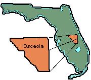

2 Osceola County

3 Osceola County Where We Were: History of Osceola Co PA Parcel Mapping Vision For The Future Project Goals Planning & Considerations
4 Osceola County Where We Went: ESRI Platform Parcel Fabric LGIM AGOL Challenges Getting There
5 Osceola County ROI & Benefits Long Term & Short Term Efficiencies Accuracy Flexibility Public Access Geo Enablement


6 History of Parcel Mapping in OCPA
7 History of Parcel Mapping in OCPA Table Digitizing AutoCAD GIS GIS LCT GIS Parcel Fabric

8 Vision For the Future Modernize GIS & Office Embrace Technology Leading Edge Where the Industry is going

9 Osceola County Leadership, Vision, & Faith
10 Project Goals Allow for more staff in house to take on creating Maps & specialized applications Integrate additional county datasets Efficient maintenance/parcel editing Comply with industry standards and best practices Migrate from Departmental to Enterprise More people can take advantage Reduce Costs (COTS vs Customized) Serve the Public Even Better
11 Planning & Considerations Hardware and software needed Integration with CAMA data Integration with other agency data Maintenance/efficiency of Parcel editing Training Additional app and Web sites Minimizing downtime
12 Planning & Consideration Modernization plan Parcel Fabric Conversion Maps and Apps New Infrastructure Goals/constraints Timeframe Database modifications Data clean up merge to LGIM Optimization Training Set up account Custom Maps & Aps
13 Osceola County Esri Platform What is it? Web GIS Access & Collaboration Where is it going Marketplace COTS Non legacy

14 Osceola County Components LGIM Parcel Fabric AGOL Maps & Apps

15 LGIM Harmonized Information Model of GIS Datasets Integrates Processes Across Typical Gov t Departments Connecting Silos of Information Ready to Use Maps and Apps Local Government Basemaps Elections Maps & Apps Infrastructure Maps & Apps Land Records Maps & Apps LGIM Database Adds Benefits of Various County Data in One Place Houses Parcel Fabric Dataset
16 LGIM District Data Parcel Data (Parcel Fabric) Centerlines Zoning Flood Zones Wetlands


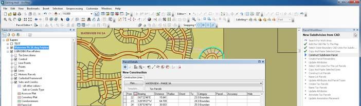
17 Parcel Fabric Data Model Geospatially Integrated Data Model Manages Topological & Spatial Relationships Inherent in Cadastral data. Makes Land Records Information Easier to Share, Edit, and Track Throughout an Organization Parcel Fabric


18 Challenges Fairly Significant Learning Curve Osceola Had DOR Deadlines Impending Had to Learn New Way of Bringing In Subdivisions Significant Amount of Subdivisions to Bring In the System Before Deadline Data Challenges Discovered Broken Arcs Large ROWs
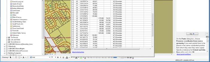
19 Benefits Efficiency Plans Table stores important survey and legal details for easy reference and elimination of duplication. Historic Parcels provide boundary history starting from time after conversion. Dimensions can be created from line attributes that are manually entered. COGO bearing and distances are saved for each line associated to a feature. Built in Workflows
20 Benefits Accuracy Control Points Are Used to Spatially Adjust/Improve Data Accuracy. Features Are Connected at Points Thus Preventing Gaps/Overlaps as Long as Best Practices are Followed. Adjustments Are Made Using Least Squares Approach.
21 Benefits Flexibility Schema is configurable and can be modified using standard geodatabase design. Schema can be expanded to support features not included in the Local Government Information Model (LGIM).
22 AGOL Collaborative Web GIS Create, Use, Organize, and Share Maps & Apps Device Independent Free Templates Configurable

23 Value Analysis Dashboard Used by assessors to visualize the impact of sales, foreclosures, and assessment appeals on property value in a neighborhood or tax district


24 AGOL


25 Public Map Gallery Commission Districts Map Online Maps & Apps Parcel Sales App Wetlands App Foreclosures App
26 AGOL Live Look At Osceola s AGOL Maps & Apps


27 Keys To Success Collaboration Regularly Scheduled Meetings ESRI Input and Guidance Staff Perseverance! Training Continuing Training & Accessibility Leadership
28 Osceola County ROI/Benefits Short Term Quick wins, publish across devices Long Term Sustainable COTS systems, better maintenance, advantage of AGOL, organizational power Minimized Risk COTS approach Increased Efficiency in Mapping & Maintenance Increased Attention to GIS and Appraiser s Office Tons of Maps & Apps at Their Finger Tips As ESRI Adds More, Creates More, and Stops Supporting Old Data Models, Osceola Will Be in Great Shape
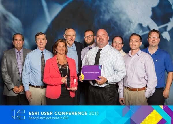
29 SAG Award


30 Osceola County
31 Osceola County What is next? Promotion of PAO Modern Positive Interaction with Citizens Collaboration With ESRI Keep Moving Forward Best Practices Light House Acct
32 Osceola County Thank you! Questions?
Walking Routes to School Program
 Walking Routes to School Program Creating Walking Routes to School using the Network Analyst Extension John Ritsko GIS Analyst City of Henderson Public Works Engineering Purpose of Program Create a WEB-based
Look Twice! Inventorying Pavement Markings for the City of Austin. Our story of how we accomplished data inventory of our city crosswalks.
 Look Twice! Inventorying Pavement Markings for the City of Austin. Our story of how we accomplished data inventory of our city crosswalks. City of Austin Austin Transportation Department Signs & Markings
Bicycle-Pedestrian Master Plan Update
 Bicycle-Pedestrian Master Plan Update Planning & Zoning Commission November 29, 2017 Overview Project Purpose & Scope Project History Plan Vision & Goals Chapter 5: Making Connections-Beyond the Path Next
Developing a Bike/Pedestrian Plan Using ArcInfo and Public Participation Rob Shumowsky, Madison County Council of Governments
 Developing a Bike/Pedestrian Plan Using ArcInfo and Public Participation Rob Shumowsky, Madison County Council of Governments Abstract: The Madison County Council of Governments is creating a bike/pedestrian
Corpus Christi Metropolitan Transportation Plan Fiscal Year Introduction:
 Introduction: The Safe, Accountable, Flexible, Efficient Transportation Equity Act: A Legacy for Users (SAFETEA-LU) has continued the efforts started through the Intermodal Surface Transportation Efficiency
WHEN WILL YOUR MULTI-TERABYTE IMAGERY STOP REQUIRING YOU TO BUY MORE DATA STORAGE?
 PRODUCT BROCHURE WHEN WILL YOUR MULTI-TERABYTE IMAGERY STOP REQUIRING YOU TO BUY MORE DATA STORAGE? WHEN YOU START COMPRESSING IT TO HEXAGON GEOSPATIAL S ECW FORMAT 2 WHEN WILL YOUR MULTI-TERABYTE IMAGERY
GIS for Public Opinion / Survey Research. Timothy Michalowski Senior Statistical GIS Analyst Abt SRBI - New York, NY
 GIS for Public Opinion / Survey Research Timothy Michalowski Senior Statistical GIS Analyst Abt SRBI - New York, NY July 17, 2014 Agenda Introduction Public Opinion / Survey Research Application of GIS
A Novel Approach to Capitalize WITSML Data in Geospatial Platform for Realtime Monitoring and Risk Assessment
 A Novel Approach to Capitalize WITSML Data in Geospatial Platform for Realtime Monitoring and Risk Assessment Dr. Sethupathi Arumugam PhD Principal Consultant Biswa Ranjan Patra Principal Consultant Shebi
Case Study. PayPal s Sparkline Case Study. About Sparkline
 Our People. Your Solution. PayPal s Sparkline Case Study Case Study PayPal, an ebay subsidiary, is a digital payment provider offering flexible payment methods with more than 81 million active accounts
Operating Committee Strategic Plan
 Operating Committee Strategic Plan September 2017 NERC Report Title Report Date I Table of Contents Preface... ii Introduction... iii Operating Committee Strategic Plan...1 Purpose of Strategic Plan...1
Performance-Based Approaches for Geometric Design of Roads. Douglas W. Harwood MRIGlobal 3 November 2014
 Performance-Based Approaches for Geometric Design of Roads Douglas W. Harwood MRIGlobal 3 November 2014 Traditional Approaches to Highway Geometric Design Based on established geometric design criteria
Minimum Bid: $7, Legal Description: DESCHUTES RIVER RECREATION HOMESITES, INC. UNIT 5; Lot 38; Block 27
 Sale ID: 2015-08 Serial: 115866 Taxlot: 201012C006300 16849 Fontana Rd. Bend, OR 97707 Zoning RR-10, WA Acreage: 0.49 TDC Number: Comments: Vacant platted legal lot. No permit history. Area of high ground
Goal 3: Foster an environment of partnerships and collaboration to connect our communities and regions to one another.
 Non-Motorized Transportation Plan (NMTP) Draft Vision, Goal and,, Tri-County Regional Planning Commission (TCRPC) Purpose The purpose of the Tri-County Regional Planning Commission (TCRPC) Non-Motorized
5. Pedestrian System. Accomplishments Over the Past Five Years
 5. Pedestrian System Accomplishments Over the Past Five Years The Alamo Area Metropolitan Planning Organization (MPO) and its partner agencies recognize the importance of improving pedestrian mobility.
A COMPREHENSIVE APPROACH TO TRANSPORTATION AT SUNTRUST PARK AND THE BATTERY ATLANTA
 A COMPREHENSIVE APPROACH TO TRANSPORTATION AT SUNTRUST PARK AND THE BATTERY ATLANTA Overview The Atlanta Braves strategically selected the location for SunTrust Park to provide an environment rich in transportation
City of Novi Non-Motorized Master Plan 2011 Executive Summary
 City of Novi Non-Motorized Master Plan 2011 Executive Summary Prepared by: February 28, 2011 Why Plan? Encouraging healthy, active lifestyles through pathway and sidewalk connectivity has been a focus
Planning for tennis in your Local Government Area. A resource from Tennis Australia
 Planning for tennis in your Local Government Area A resource from Tennis Australia Part 1 July 2016 ABOUT THIS RESOURCE This resource forms part of Tennis Australia's Local Government Engagement Program.
Statewide Cycloplan: Bicycle Planning Tool & Participatory GIS
 Statewide Cycloplan: Bicycle Planning Tool & Participatory GIS Loren Terveen, Principal Investigator Department of Computer Science University of Minnesota June 2015 Research Project Final Report 2015-29
Eugene s Strategic Pedestrian and Bicycle Plan
 Eugene s Strategic Pedestrian and Bicycle Plan Moving Beyond Infrastructure: Planning for Action City of Eugene Public Works Engineering Pro Walk / Pro Bike Seattle 2008 www.eugene-or.gov/walkbike Agenda
FHWA Resources for Pedestrian and Bicycle Professionals
 FHWA Resources for Pedestrian and Bicycle Professionals Charlie Zegeer, UNC Highway Safety Research Center/PBIC Libby Thomas, UNC Highway Safety Research Center Dan Nabors, Vanasse Hangen Brustlin (VHB)
Evolution of Deepwater Coral Protection in the Southeast U.S
 Evolution of Deepwater Coral Protection in the Southeast U.S Tina Udouj, Florida Fish and Wildlife Conservation Commission Roger Pugliese, South Atlantic Fishery Management Council Overview Deepwater Corals
Stakeholder Communication and Public Involvement Plan
 Stakeholder Communication and Public Involvement Plan Arkansas Statewide Bicycle and Pedestrian Transportation Plan Plan purpose: The Arkansas State Bicycle and Pedestrian Plan will establish a framework
Spatial Analysis of Bicycle and Pedestrian Collisions and Factors Corina Chung, MS Epidemiologist Jessica Garner Community Health Planner
 Spatial Analysis of Bicycle and Pedestrian Collisions and Factors Corina Chung, MS Epidemiologist Jessica Garner Community Health Planner Get Healthy San Mateo County (GHSMC): A Local Collaborative Building
Analysis Data Sources
 Page Technical Appendix D 1 SMP Analysis Data Sources the set bathymetry levee riprap mine lakebath_arc FloodHazardD ata.mdb\flood HazardZoneCo mponents\fhcl evee FloodHazardD ata.mdb\flood HazardZoneCo
1/9/2018. City Council City Hall Wilmington, North Carolina Dear Mayor and Councilmembers:
 ITEM O2 OFFICE OF THE CITY MANAGER (910) 341-7810 FAX (910)341-5839 TDD (910)341-7873 1/9/2018 City Council City Hall Wilmington, North Carolina 28401 Dear Mayor and Councilmembers: On March 21, 2017,
PDX Overview & Adoption
 The Product Data exchange Standard: PDX Overview & Adoption Barbara Goldstein bgoldstein@nist.gov 30 August 2004 Outline Business Drivers for PDX What is PDX? PDX Adoption Plans for PDX V2.0 Material Declaration
Modeling and Mapping Metro s Rail Stations
 Washington Metropolitan Area Transit Authority Modeling and Mapping Metro s Rail Stations Minhua Wang GIS Enterprise Architect mwang@wmata.com Voliya Arakkal Sr. GIS Analyst varakkal@wmata.com Andrew Oldham
5.0 Roadway System Plan
 Southwest Boise Transportation Study Page 16 5.0 Roadway System Plan The Roadway System Plan outlines roadway improvements in the Initial Study Area. It forecasts future deficiencies on the arterial system,
City of West Des Moines PAVEMENT MANAGEMENT SYSTEM
 City of West Des Moines PAVEMENT MANAGEMENT SYSTEM 12/11/2018 Municipal Street Seminar (11-14-2018) JEFF NASH 1 City Background Information: - West Des Moines current census Population is around 66,000
A GIS APPROACH TO EVALUATE BUS STOP ACCESSIBILITY
 Advanced OR and AI Methods in Transportation A GIS APPROACH TO EVALUATE BUS STOP ACCESSIBILITY Giuseppe SALVO 1, Simona SABATINI 2 Abstract. This paper proposes a methodology to assess public transportation
Growing Bicycle Travel & Tourism for Economic Development Jeff Miller, VP North America
 Growing Bicycle Travel & Tourism for Economic Development Jeff Miller, VP North America 202-445-4415 Jeff@CycleLifeHQ.com 1 2 3 4 Growing Bicycle Travel & Tourism for Economic Development Jeff Miller,
Advanced Test Equipment Rentals ATEC (2832) OMS 600
 OMS 600") Established 1981 Advanced Test Equipment Rentals www.atecorp.com 800-404-ATEC (2832) OMS 600 Continuous partial discharge monitoring system for power generators and electrical motors Condition monitoring
Established 1981 Advanced Test Equipment Rentals www.atecorp.com 800-404-ATEC (2832) OMS 600 Continuous partial discharge monitoring system for power generators and electrical motors Condition monitoring
MAPPING DESCRIPTIONS AND DRAFTING PARCEL BOUNDARIES FOR CADASTRAL MAPPING
 MAPPING DESCRIPTIONS AND DRAFTING PARCEL BOUNDARIES FOR CADASTRAL MAPPING Chapter 6 2015 Cadastral Mapping Manual 6-0 Another method of describing land, aside from the fractional section method, is called
Pedestrian Issues and Safety Initiatives in Railroad Corridors
 Pedestrian Issues and Safety Initiatives in Railroad Corridors Sponsored by ITE Combined Grade Crossings Committee TENC 102-02 FRA Perspectives on Pedestrian Safety at Grade Crossings Brian F. Gilleran,
Hennepin County Bicycle and Pedestrian Planning
 Hennepin County Bicycle and Pedestrian Planning 1 Value of bicycle and sidewalk systems Safety Livability Mobility Health Personal Finances Economic Sustainability Clean Air Recreation Parking and congestion
Shared Resource Conservation Manager Program Report Washington State University Energy Program, March 2013
 Vancouver Partnership Jurisdictions and Geography The Vancouver RCM partnership consists of the cities of Vancouver, Washougal and Camas, located in southwest Washington bordering the Columbia River. Vancouver
TOWN OF PORTLAND, CONNECTICUT COMPLETE STREETS POLICY
 TOWN OF PORTLAND, CONNECTICUT COMPLETE STREETS POLICY I. VISION, GOALS & PRINCIPLES VISION To improve the streets of Portland making them safer and more accessible for all users including pedestrians,
BIKE PLAN CONTENTS GATEWAY
 CONTENTS Acknowledgments...vii Great Rivers Greenway District Board of Directors... vii Great Rivers Greenway District Staff... vii Project Consultants... vii Committees... viii Citizens Advisory Committee
Raiser s Edge NXT: Moving to and Mastering the Next Generation of RE. Bill Connors, CFRE, bcre-pro
 Raiser s Edge NXT: Moving to and Mastering the Next Generation of RE Bill Connors, CFRE, bcre-pro Social Goodness @BillConnorsCFRE linkedin.com/in/billconnorscfre Make sure to use the hashtag #bbcon! Agenda
Ann Arbor Downtown Street Plan
 1 Ann Arbor Downtown Street Plan Public Workshop #1 We know that. 2 Public right-of-way (streets, sidewalks, and alleys) make up 30% of the total District area of downtown. Streets need to provide mobility
Non-Motorized Transport (NMT) Development. Gerald Ollivier Transport Cluster Leader Transport Global Practice The World Bank
 Development. Gerald Ollivier Transport Cluster Leader Transport Global Practice The World Bank") Non-Motorized Transport (NMT) Development Gerald Ollivier Transport Cluster Leader Transport Global Practice The World Bank In China, national plan and policy prioritize NMT development The 13 th Five
Non-Motorized Transport (NMT) Development Gerald Ollivier Transport Cluster Leader Transport Global Practice The World Bank In China, national plan and policy prioritize NMT development The 13 th Five
Vision Zero and Beyond: A Simple Yet Powerful Data Strategy for Evaluating Potential Engineering Solutions
 0 0 Vision Zero and Beyond: A Simple Yet Powerful Data Strategy for Evaluating Potential Engineering Solutions Tim Black, Corresponding Author Public Health Foundation Enterprises, Inc. 0 Crossroads Parkway
DRAFT MOVING FORWARD RHODE ISLAND BICYCLE MOBILITY PLAN 2018 PREPARED FOR PREPARED BY IN ASSOCIATION WITH
 RHODE ISLAND MOVING FORWARD BICYCLE MOBILITY PLAN 2018 PREPARED FOR PREPARED BY IN ASSOCIATION WITH T AF CHAPTER 1 D R INTRODUCTION CHAPTER 3 ARTICULATES VISION Bicycling is safe, fun and practical in
AMATS Complete Streets Policy
 AMATS Complete Streets Policy Table of Contents: Section 1. Definition of Complete Streets Section 2. Principles of Complete Streets Section 3. Complete Streets Policy Section 4. Consistency Section 5.
Blue Ribbon Commission Report Recommendations on Pedestrian and Bicycle Infrastructure Improvements
 Recommendations on Pedestrian and Bicycle Infrastructure Improvements July 2017 Plan Development: Our committee consisted of seven individuals appointed by the Mayor and Village Board. Those members included:
Access Management Regulations and Standards for Minor Arterials, Collectors, Local Streets
 Access Management Regulations and Standards for Minor Arterials, Collectors, Local Streets September 2009 Paul Grasewicz Access Management Administrator Concept of Access Management The way to manage access
Fuel Economy Fiscal Measures - Feebate Tool Training
 Fuel Economy Fiscal Measures - Feebate Tool Training Zifei Yang Researcher GFEI, Paris June 10, 2016 Overview Fiscal measures to improve vehicle fuel efficiency Highlight of the day- feebate program Feebate
Access Management Regulations and Standards
 Access Management Regulations and Standards Efficient highway operation Reasonable property access Concept of Access Management The way to manage access to land development while simultaneously preserving
2019 Annual Recalculation and Reappraisal Setup Studies for All Residential Properties in Columbia County for Property Tax Assessment
 2019 Annual Recalculation and Reappraisal Setup Studies for All Residential Properties in Columbia County for Property Tax Assessment Published by the Columbia County Assessor January 2, 2019 Table of
City of Homewood Transportation Plan
 City of Homewood Transportation Plan Prepared for: City of Homewood, Alabama Prepared by: Skipper Consulting, Inc. May 2007 TABLE OF CONTENTS INTRODUCTION... 1 BACKGROUND INFORMATION... 1 EXISTING TRANSPORTATION
Focus on Enforcement. 3/14/2017 Presentation to the Vision Zero Taskforce. Joe Lapka Corina Monzón
 Focus on Enforcement Insights from research and analysis in support of San Francisco s Vision Zero plan to eliminate traffic deaths Joe Lapka Corina Monzón 3/14/2017 Presentation to the Vision Zero Taskforce
Safety Through Technology. gastag.co.uk
 Safety Through Technology 1 The future of gas safety is here... 1 Issues in the industry... 2 5 Introducing Gas Tag... 6 Eliminating the possibility of rogue gas work... 7 The four elements... 8 9 How
Pedestrian, Bicycle and Traffic Calming Strategic Implementation Plan. January 18, 2011
 Pedestrian, Bicycle and Traffic Calming Strategic Implementation Plan January 18, 2011 Tonight s Agenda Receive update on project Provide feedback on two policy issues Complete Streets Policy Project Prioritization
The Role of MPOs in Advancing Safe Routes to School through the Transportation Alternatives Program
 The Role of MPOs in Advancing Safe Routes to School through the Transportation Alternatives Program In 2012, Congress made changes to Federal funding for Safe Routes to School that gave some metropolitan
APPROVE A RESOLUTION ADOPTING A COMPLETE STREETS POLICY
 STAFF REPORT MEETING DATE: September 13, 2016 TO: FROM: City Council Bob Brown, Community Development Director Russ Thompson, Public Works Director Patrick Filipelli, Management Analyst 922 Machin Avenue
Vision Zero High Injury Network Methodology
 Vision Zero High Injury Network Methodology DATA SETS USED: 1. Reportable crashes in Philadelphia from 2012-2016, available as open data through PennDOT 2. Street Centerline geographic layer, maintained
UTAH HUNTING AND FISHING
 UTAH HUNTING AND FISHING Category: Emerging and Innovative Technologies Contact: David Fletcher State of Utah Project Initiation and Completion Dates: April 2014-October 2014 NASCIO 2015 1 EXECUTIVE SUMMARY
Regional Database of Mineral Flows
 PARTNERSHIP AFRICA CANADA Engagement with the ICGLR to Address Illegal Exploitation of Natural Resources- 2016 Partnership Africa Canada s (PAC) support to the ICGLR and ICGLR Member States to address
The German Spatial Data Strategy
 The German Spatial Data Strategy Presented at the FIG Working Week 2016, May 2-6, 2016 in Christchurch, New Zealand The world with spatial data in 2025 FIG Congress 2016, May 5th Susanne Kleemann Federal
Spatial Collaboration in Austria. Impact on INSPIRE and e-government. Wolfgang Fahrner, Markus Jobst INSPIRE conference
 Spatial Collaboration in Austria Impact on INSPIRE and e-government Wolfgang Fahrner, Markus Jobst INSPIRE conference 2018 1 Spatial Custodianship in AT - Agenda Modern Map Production and decentralized
Student Population Projections By Residence. School Year 2016/2017 Report Projections 2017/ /27. Prepared by:
 Student Population Projections By Residence School Year 2016/2017 Report Projections 2017/18 2026/27 Prepared by: Revised October 31, 2016 Los Gatos Union School District TABLE OF CONTENTS Introduction
PROJECT BACKGROUND/DESCRIPTION
 SCOPE OF SERVICES St. Charles Parish Comprehensive Pedestrian and Bicycle Master Plan (CPBP) St. Charles Parish, Louisiana State Project No. H. 012462 RPC Project No. SCPBMP1 PROJECT BACKGROUND/DESCRIPTION
Minimum Bid: $4, Legal Description: DESCHUTES RIVER RECREATION HOMESITES UNIT 6, PART II, Lot 12, Block 79.
 Sale ID: 2016-17 Serial: 126490 Taxlot: 211002B004500 54688 Silver Fox Dr. Bend, OR 97707 Zoning RR-10; LM; WA Acreage: 0.34 Comments: Vacant platted lot (legal lot of record). In area of high groundwater
GOVERNMENT OF SASKATCHEWAN SUBMISSION TO THE RAILWAY SAFETY ACT REVIEW PANEL
 GOVERNMENT OF SASKATCHEWAN SUBMISSION TO THE RAILWAY SAFETY ACT REVIEW PANEL Saskatchewan Highways & Transportation May 29, 2007 I Introduction Government of Saskatchewan Submission To the Railway Safety
March 6, 2013 Tony Giarrusso, Rama Sivakumar Center for GIS, Georgia Institute of Technology
 March 6, 2013 Tony Giarrusso, Rama Sivakumar Center for GIS, Georgia Institute of Technology 33 46 35.74 N, 83 23 48.33 W Location: Georgia Institute of Technology, College of Architecture Established:1996
Spatial Patterns / relationships. Model / Predict
 Human Environment Spatial Patterns / relationships Model / Predict 2 3 4 5 6 Comparing Neighborhoods with high Quality of Life & health Overlap matrix NPUs with high NH & NQoL SEC High QoL High Health
Bikesharing in. Barcelona
 Bikesharing in Barcelona 01 THE EVOLUTION OF TRANSPORT MODEL FOR INDIVIDUALS USING BICYCLES 2 THE EVOLUTION OF TRANSPORT MODEL FOR INDIVIDUALS USING BICYCLES 80 s-90 s Private motorized vehicle as a the
Application of new information system and technologies to road management & control at ANAS S.p.A.
 November 6th - 8th, 2013 Hotel Panamericano City of Buenos Aires, Argentina URBAN MOBILITY, ROADS NETWORK OPERATION AND ITS APPLICATIONS Application of new information system and technologies to road management
The Kanban Guide for Scrum Teams
 The Kanban Guide for Scrum Teams February 2018 Developed and sustained by Scrum.org and Daniel Vacaniti Table of Contents Purpose... 3 Relation to the Scrum Guide... 3 Definition of Kanban... 3 Kanban
Environment and Public Works Committee Presentation
 Mixed Use Centers Complete Streets Guidelines Project Environment and Public Works Committee Presentation December 10, 2008 Project Objectives: Conduct an inter-departmental and agency process to study
EMERGENCY MEDICAL SERVICES DATA IN ILLINOIS
 EMERGENCY MEDICAL SERVICES DATA IN ILLINOIS 58 TH ANNUAL ILLINOIS TRAFFIC ENGINEERING AND SAFETY CONFERENCE OCTOBER 22, 2009 Illinois Department of Public Health Damon T. Arnold, MD, MPH, Director QUESTIONS
TOWN OF PARADISE VALLEY
 TOWN OF PARADISE VALLEY The Paradise Valley Bicycle & Pedestrian Master Plan Planning Commission January 16, 2018 Purpose of Today s Meeting Review January 2018 draft plan Input on compliance to SOD Review
Estimation of damages caused by storm tides in the city of Hamburg K.-H. Pöschke DHI-WASY GmbH Waltersdorfer Str. 105, Berlin, Germany
 Estimation of damages caused by storm tides in the city of Hamburg K.-H. Pöschke DHI-WASY GmbH Waltersdorfer Str. 105, 12526 Berlin, Germany 1 Introduction The city of Hamburg is potentially endangered
AGENDA. Stakeholder Workshop
 AGENDA Stakeholder Workshop 19 th February DLF City Club, Gurgaon IBI GROUP Defining the cities of tomorrow 1 WORKSHOP AGENDA IBI GROUP Defining the cities of tomorrow 2 INTRODUCTION TO THE PBS GUIDANCE
City of Springboro Bicycle & Pedestrian Plan
 City of Springboro Bicycle & Pedestrian Plan Public Visioning Workshop Documentation of Input August 24, 2012 List of Figures Public Input A Public Visioning Workshop was held on August 7, 2012 from 6:00
Public Transportation and Bicycle & Pedestrian Stakeholder Webinar. April 11, :30 PM
 Public Transportation and Bicycle & Pedestrian Stakeholder Webinar April 11, 2013 1:30 PM Public Transportation and Bicycle & Pedestrian Webinar April 11, 2013 1:30 PM MULTIMODAL TRANSPORTATION PLAN Vision,
World Rowing s Strategic Framework
 World Rowing s Strategic Framework World Rowing s Strategic Framework Fédération Internationale des Sociétés d Aviron (FISA) Guiding Principles FISA was formed in 1892 and is the first international sport
Traffic Impact Memorandum. May 22, 2018
 BISHOP PROFESSIONAL DEVELOPMENT BUILDING Proposed Land-use Change & Parking Modification 3601 SW 31st Street Topeka, Kansas 66614 CFS Project No. 185077 Traffic Impact Memorandum May 22, 2018 Prepared
Wangaratta & District Cricket Association
 Wangaratta & District Cricket Association FROM THE PRESIDENT The Wangaratta and Distrcit Cricket Association has for many years enjoyed a reputation for strong administration, developing expanding domestic
ENGINEERING DRIVER SAFETY INTO PAVEMENT PRESERVATION
 ENGINEERING DRIVER SAFETY INTO PAVEMENT PRESERVATION 2015 TxDOT Short Course Miguel Arellano, P.E. Austin District Pavement Engineer October 13, 2015 Table of Contents 1 Goals: Overall Reduction in Crashes
Case Study: Team Penske Team Penske How a championship-winning race team cut engineering cycles by 30%
 Team Penske How a championship-winning race team cut engineering cycles by 30% Advanced project management software speeds performance improvements to the track. 400 major race wins 16 Indy 500 wins 29
VIRGINIA 4-H CHARTERING INSTRUCTIONS
 2017-2018 VIRGINIA 4-H CHARTERING INSTRUCTIONS 0 PAGE 2017 2018 Virginia 4-H Youth Development Program Table of Contents Section 1: What is a Charter... 3 Purpose of Establishing and Chartering a 4-H Club...
Safety Assessment of Installing Traffic Signals at High-Speed Expressway Intersections
 Safety Assessment of Installing Traffic Signals at High-Speed Expressway Intersections Todd Knox Center for Transportation Research and Education Iowa State University 2901 South Loop Drive, Suite 3100
Tulsa Metropolitan Area LONG RANGE TRANSPORTATION PLAN
 Tulsa Metropolitan Area LONG RANGE TRANSPORTATION PLAN Indian Nations Council of Governments August 2005 CONTACTING INCOG In developing the Destination 2030 Long Range Transportation Plan, INCOG s Transportation
City of Los Angeler CALIFORNIA. ANTONIO R. VILlARAIGOSA MAYOR
 JUNE lagmay CITY CLERK HOLLY L. WOLCOTT EXECUTIVE OFFICER City of Los Angeler CALIFORNIA ANTONIO R. VILlARAIGOSA MAYOR OFFICE OF THE CITY CLERK ADMINISTRATIVE SERVICES SPECIAL ASSESSMENTS SECTION 200 N.
Roadway Classification Design Standards and Policies. Pueblo, Colorado November, 2004
 Roadway Classification Design Standards and Policies Pueblo, Colorado November, 2004 Table of Contents Page Chapter 1. General Provisions 1.1 Jurisdiction 3 1.2 Purpose and Intent 3 1.3 Modification 3
make people aware of the department s actions for improving the deer population monitoring system,
 Investing in Wisconsin s Whitetails 1 Over the last 60 years, the department has developed a deer herd monitoring and management system that seeks to use the best science and data possible. The deer monitoring
Marin County, CA. Key Findings The NCS is presented by NRC in collaboration with ICMA
 Marin County, CA Key Findings 2019 The NCS is presented by NRC in collaboration with ICMA National Research Center, Inc. 25 years conducting survey research for local government Wrote the books on citizen
DESKTOP SKILLS COURSEWARE
 Introducing Mac OS X Yosemite Course... ds_maco_a01_dt_enus Working with Mac OS X Yosemite Course... ds_maco_a02_dt_enus Installing Mac OS X Yosemite Course... ds_macp_a01_dt_enus Managing and Configuring
PennDOT Access Management Model Ordinances Training
 PennDOT Access s Training Trainers: Chad Dixson, AICP, TPD Angela Watson, PB Objective of Today Assist Pennsylvania s municipalities and transportation professionals in better understanding the benefits
Release notes Chesar 3.3
 15/11/2017 Release notes Chesar 3.3 Contents 1. WHAT IS NEW IN CHESAR 3.3... 2 1.1. ALIGNMENT WITH IUCLID... 2 1.2. USE MAP RELATED FEATURES... 2 1.3. SCOPE OF ASSESSMENT... 3 1.4. EXPOSURE ASSESSMENT...
Norwegian Coastal Administration (NCA) HSSC November 2015 Busan - Republic of Korea
 HSSC November 2015 Busan - Republic of Korea") Norwegian Coastal Administration (NCA) HSSC7 9-13 November 2015 Busan - Republic of Korea Requirements relating to sector lights for Electronic Navigational Chart (ENC) Product Specifications B E Krosness
Norwegian Coastal Administration (NCA) HSSC7 9-13 November 2015 Busan - Republic of Korea Requirements relating to sector lights for Electronic Navigational Chart (ENC) Product Specifications B E Krosness
METHODOLOGY. Signalized Intersection Average Control Delay (sec/veh)
") Chapter 5 Traffic Analysis 5.1 SUMMARY US /West 6 th Street assumes a unique role in the Lawrence Douglas County transportation system. This principal arterial street currently conveys commuter traffic
Chapter 5 Traffic Analysis 5.1 SUMMARY US /West 6 th Street assumes a unique role in the Lawrence Douglas County transportation system. This principal arterial street currently conveys commuter traffic
How a championshipwinning. cut engineering cycles by 30% Advanced project management software speeds performance improvements to the track.
 TEAM PENSKE How a championshipwinning race team cut engineering cycles by 30% Advanced project management software speeds performance improvements to the track. CHALLENGE SOLUTION RESULTS View Overview
ADA Transition Plan. City of Gainesville FY19-FY28. Date: November 5, Prepared by: City Of Gainesville Department of Mobility
 ADA Transition Plan FY19-FY28 Date: November 5, 2018 Prepared by: City Of Gainesville Department of Mobility 1.0 INTRODUCTION 1.1 BACKGROUND The federal statute known as the Americans with Disabilities
FIRST AMENDMENT TO METRO NORTH CROSSING TAX INCREMENT FINANCING PLAN
 FIRST AMENDMENT TO METRO NORTH CROSSING TAX INCREMENT FINANCING PLAN KANSAS CITY, MISSOURI TIF COMMISSION APPROVAL: 12/13/17 12-2-17 DATE RESOLUTION NO. CITY COUNCIL APPROVAL: 2/1/18 180020 DATE ORDINANCE
We re Blue Marlin Systems, a global provider of On-site and Offsite IT Outsourcing services.
 We re Blue Marlin Systems, a global provider of On-site and Offsite IT Outsourcing services. O V E R V I E W Our mission, quite simply, is to form strategic alliances with our customers. We do so by providing
Sidewalk Network Inventory and Assessment A Self-Evaluation for the City of Sioux Falls, SD. December 1, 2017
 Sidewalk Network Inventory and Assessment A Self-Evaluation for the City of Sioux Falls, SD December 1, 2017 1 Executive Summary The Sidewalk Network Inventory and Assessment was a initiative to create
Advisory Committee on Non-Motorized Transportation
 2014-2015 Report from the Advisory Committee on Non-Motorized Transportation April 2016 Prepared by Minnesota Department of Transportation 395 John Ireland Boulevard Saint Paul, Minnesota 55155-1899 Phone:
SHORT TERM SCIENTIFIC MISSION (STSM) SCIENTIFIC REPORT
 SCIENTIFIC REPORT") SHORT TERM SCIENTIFIC MISSION (STSM) SCIENTIFIC REPORT Mapping Urban Cycling in Malta by Diego Fabian Pajarito Grajales Action Number: Reference Number Grantee Name Institution Mail: STSM Title: STSM start
SHORT TERM SCIENTIFIC MISSION (STSM) SCIENTIFIC REPORT Mapping Urban Cycling in Malta by Diego Fabian Pajarito Grajales Action Number: Reference Number Grantee Name Institution Mail: STSM Title: STSM start