RAS AL KHAIMAH EMIRATE
|
|
|
- Edwina Hubbard
- 6 years ago
- Views:
Transcription
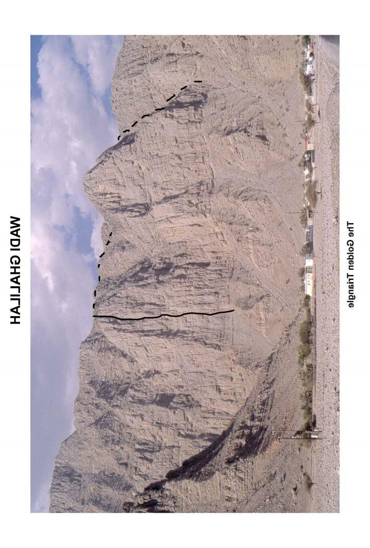
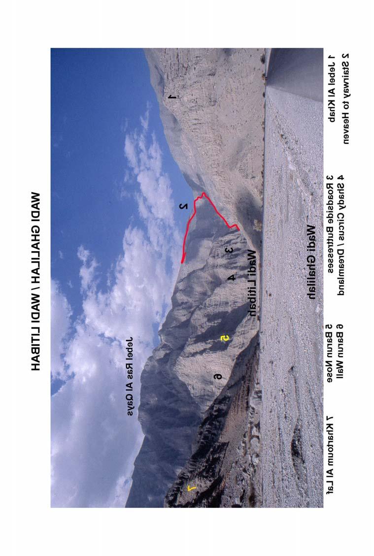
1 RAS AL KHAIMAH EMIRATE WADI GHALILAH This spectacular wadi, in the extreme north of the UAE, is arguably the most impressive area described in the guide. Lying close to the coast, it is less extensive than Wadi Bih, but contains a vast amount of steep rock. Whilst some smaller cliffs rise directly from the wadi floor, many of the routes are major undertakings of Dolomite proportions. The longest route to date approaches 600 metres in height, and longer routes are waiting to be done. They are sure to prove serious undertakings with some loose sections, and difficult descents. Its low altitude and proximity to the coast, makes year round climbing difficult due to heat and humidity. Many faces receive little shade. No records exist of any climbing or serious mountaineering before 1997, even though descriptions of the 'Stairway' and the walking route to the summit of Jebel Bil Ays were included in a small photocopied leaflet by Tony and Alice Gardner in This ignores the remarkable feats carried out by the local Shihuh tribesmen in centuries past, making a network of pathways from the valley to the plateau some 1000 m above. Building the dry stone staircases that link ledges and ramps on the upper walls must have been a monumental task, considering the tremendous exposure, and the size of the stone blocks used. These wonderful old routes can best be compared in size and scale to the 'Via Ferrata' in the Alps and Dolomites, where chains, ladders and metal handrails have been fixed to make passage easier and safer. These routes are similar, -- minus the Ferrata! APPROACH From Ras Al Khaimah, continue north on the main highway via the small town of Rams for about 25km, heading towards Mina Saqr, until the industrial area, quarries and cement works are reached. Immediately beyond the last of the cement works, a newly surfaced road leads off to the right, along side the boundary fence. After a couple of hundred metres this joins a road which skirts the quarry spoil heaps and leads straight into Wadi Ghalilah. The road passes a large water tower, and continues through a village where there are some vicious and poorly marked speed bumps. To the south of the village, is a large face containing three main buttresses. The central buttress is taken by La Petite Tomate. Beyond the village is a new telecom pylon (approx 6.5km from the main road). To the right of the road, above a cluster of fairly new buildings and a small shop, is the spur of Khartoum Al Laf, which is the northern ridge of Jebel Had al Sawah. The west face of this ridge has two large triangular faces over 400 metres high. The right hand one is known as The Golden Triangle. Beyond the pylon, the metalled road continues to the village of Al Khab. Just before the village, after crossing a wadi-wash, a track leads off to the right into Wadi Litibah (Wadi Al Kabs -- map names vary). Directly above the village a fine craggy ridge extends southwards towards the track above some walled fields, (Jebel Al Khab?). The cliffs become bigger and steeper above the village, but to date, with so much other rock available, the faces above the village have been left well alone. The main climbing areas in Wadi Litibah are some 2.5km from the tarmac road. The track is very rough, and is only suitable for 4WD vehicles having good ground clearance. At the time of writing, normal cars can get about 1.5km up the track (parking and turning space for 2 cars only), but this could change with one heavy thunder storm!! About 1km from the tarmac, a rough track leads off to the right to a settlement, which guards the entrance to the subsidiary valley of Wadi Barun. Beyond Wadi Barun, are the complex tiers, ridges and gullies of Jebel Ras Al Qays (1700m)

2 The lower tiers of this mountain have yielded some excellent shorter routes, with longer expeditions possible on the upper tiers. A number of impressive side wadis are totally unexplored. The big walls at the head of the wadi are likewise untouched, mainly due to the long approach, and short climbing season. At the head of the main track is a collection of rough stone dwellings, which are still inhabited or regularly visited by local families. They locals are generally very friendly, but it is advisable to respect their privacy and Islamic traditions and avoid contact unless they indicate otherwise. Vehicles may be left a short distance away from the settlement, taking care not to block the track, and to park on a high spot if there is the possibility of any rain. Sadly, some vandalism has occurred to vehicles parked close to the dwellings and left unattended, particularly to those belonging to people doing the "Stairway" routes so be wary. Beyond the settlement, on the right, is a large side wadi, which holds a number of unexplored cliffs, and which may provide a possible way to and from the summit of Jebel Ras Al Qays. The locals say there is no pathway to the summit, but one can never be sure. Further on, the wadi enters a gorge with immense rubble slopes on both sides. A track on the right side of the wadi, avoids the worst of the jumble of boulders in the wadi bed, and passes below a series of crags, on its way to the impressive amphitheatre at the head of the wadi. Local tribesmen have used this wadi for generations as a means of access to the Shihuh villages of high plateau beyond. The climbing areas are described in order of approach from the cement works road. KHARTOUM AL LAF Directly above the main village, to the south of the road, is a large face with several distinct buttresses. In true Antoine fashion, the only route to date takes a fairly direct line up the central buttress. LA PETITE TOMATE 300m TD, V. A Fabre, C Redard, 2002 No description available, but then again they didn t have one either! Typical of Antoiine, just pick the best looking line in the centre of the face or up a prominent rib. If you find it harder or easier than grade V, then you re probably on a different line. Antoine s photo should at least get you on the correct buttress. Beyond the village, near to the large pylon, is a cluster of fairly new dwellings and a small shop. Two large triangular faces lie directly above. To date only one route has been climbed on these impressive faces. A typical Antoine route -- straight up the centre of the face to the summit! ***THE GOLDEN TRIANGLE 500m E1 5b (TD+) A Fabre, B Wheeler 1999 The route takes a more or less direct line up the centre of the right hand triangle. Follow a thin crack in the centre of the face for 4 pitches (IV/ V) to gain a major ledge that cuts across the face. Traverse 50 m left along the ledge to avoid an overhanging zone, and climb a band of loose yellow rock to reach a crack that leads back right in to the main crack line. Follow this directly for 7 pitches (V / V+) to reach the top. From the top, the best descent is to reach the crest of the ridge, and follow this downwards until an escape can be made to easier angled ground on the back side of the ridge. Allow at least one hour for the descent
3 25 26


4 JEBEL AL KHAB FLYING VISIT 70m VS 5a (TD-) A Fabre, B Wheeler 2000 March Takes the obvious right facing line of corners directly below the high point, near the right hand end of the ridge above the fields. 4 pitches. The second pitch is V/V+, whilst the rest is about IV / V. It gains a ledge system at about half height, and exits rightwards onto the ridge and easy way down. The Walls to the left of the route increase in height, and would appear to offer more lines, but are closer to a large village, and are best left undisturbed, until climbers become better accepted

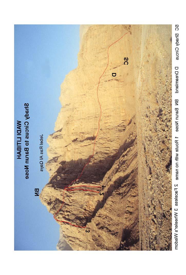
5 WADI LITIBAH Before describing the climbing I make no apology for including a scrambling route, which would be a classic anywhere in the world. STAIRWAY TO HEAVEN. This five star expedition with over 2000 metres of ascent and descent, is not for the unfit, inexperienced or the faint hearted. A Via Ferrata minus The Ferrata. The complete circular route, including descent takes approx hours depending on fitness, heat and humidity. A stunning route that makes an elegant way from the valley floor, to the lowest point on the rim of the plateau. It continues over one of the minor summits before finding an equally spectacular but slightly less exposed route back to the valley floor. The very fit, or those prepared to bivouac, can also take in the ascent of Jebel Bil Ays 1921m, one of the highest mountains in the region. The route is highly exposed to flash flooding, and should not be attempted if there is any likelihood of rain. From the head of the 4WD track, continue up the wadi bed for about 400 m, passing a side valley on the right. The wadi bed can be follwed in its entirety to the head of the wadi, but in places it is a tedious struggle through a boulder field. It can be bypassed by a well used track, which halves the time to reach the wadi head. A rock buttress (Lower Gorge Crag) extends down almost to the wadi bed. Leave the wadi bed, and gain a very faint track passing below Lower Gorge Crag. The track is indistinct in places, and can often only be followed by looking for rocks, which have been polished like black glass, through centuries of use. In places the path is exposed, and care must be taken especially where wash outs have occurred during the rainy season. The rubble slopes are highly unstable, and should be avoided where possible. Eventually the path leads through some deserted settlements and grass pastures, to an impressive amphitheatre of cliffs almost 1000 m high. Approx.½ - ¾ hr. (Honestly there were grass pastures there, -- I've got photos) On the left side, facing up the valley, an indistinct path leads steeply upwards behind a ridge that falls from the upper left walls to the valley floor. Continue upwards, looking for telltale signs, eroded ground, polished rock, donkey droppings, discarded Flip Flops and food cans, until the lower section of the headwall is reached. The top of the wall is some 500 m vertically above, with no feasible direct way. A vague path leads left round a rib to a long sloping and narrowing shelf, with polish marks being the only clues. The exposure increases dramatically as the path weaves its way ever higher. Eventually the way heads back rightwards, and the angle increases, necessitating the occasional use of hands. Vertical sections, up to 20 m high at a time, are overcome by climbing stone stairways. About 200 m up the headwall, an exposed and polished traverse rightwards gives access to yet another long staircase. After this, the going becomes a little less exciting, then after another 60 or 70 m the rim of the plateau is reached. You have now crossed the border into Oman. Approx. 2-3 hours from the foot of the climb. A collection of stone buildings and neatly tended fields surrounds a shallow valley. The local tribesmen are not used to strangers, so it is probably better to avoid contact if possible. From the dwellings, continue across the valley, bearing rightwards and ascend the rounded peak (1600 m) almost directly ahead. There is no proper track, but rough ground makes the 2km, / 250 m height gain seem much more. From the high point, continue in a clockwise direction, following the rim of the plateau, to reach another small settlement perched on a promontory

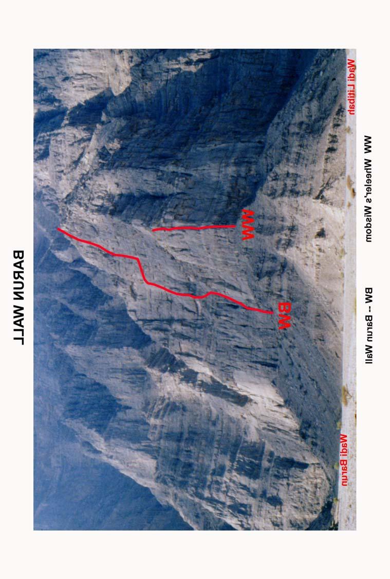
6 A faint track leads down into a side valley, and then climbs to a bigger group of dwellings perched on a narrow spur surrounded by large cliffs. About 2-3 hours from the top of the stairway. From this village, a way can be found down another stairway, which eventually leads to some lower pastures. This descent is less exposed than on the other side of the wadi, but as you descend, it is easy to lose the best way in a large boulder field. Eventually upon reaching the lower fields, a vague donkey track can be found leading rightwards into an large gully system, which is an enormous waterfall in the rainy season, witnessed by very few people. The path, which is fairly well defined at this point, continues directly under the line of the fall, where a large pool can be found under an overhang. The gully plunges down-wards for at least 100 metres, but a narrow ledge cuts across the cliff face. The walls overhang above, and are grossly undercut below. Rock debris from the upper walls litters the ledge, and in places makes passage awkward. It is an oppressive place with intimidating exposure. The ledge continues almost horizontally for m, breaking out onto an easy angled slope and descent path. Continue down to rejoin the main pathway at the fork in the gorge. (About 2-3 hours from the plateau) From there, the vehicles are reached in about 45 minutes of relatively easy walking. WADI LITIBAH -- The Climbing The main climbs are situated on the northern flanks of Jebel Ras Al Qays. A subsidiary set of peaks, ridges and faces, rise directly from the floor of the wadi. None of the buttresses or subsidiary peaks appear to be named on local maps. The local Shihuh dialect is difficult to understand, but then again so is my Arabic. The climbing areas are described in order as seen when approaching up the valley. JEBEL RAS AL QAYS 1750m On the right (south) hand side of the wadi, after passing a prominent side valley (Wadi Barun), is a complex mountain rising to a height of approx metres. It appears ringed with high steep crags on all sides, with no obvious easy approach and descent. The mountain has many fine ridges, steep faces, walls and buttresses that are broken into tiers. Some of the tiers are more than 500m high. The first climbing area is on a big wall beyond the dwellings guarding the entrance to Wadi Barun. BARUN WALL This is one of the biggest continuous faces in the UAE at around 600 metres high. It s only route to date was initially attempted, by Antoine Fabre and Bill Wheeler. Progress was halted after about 400 metres when Bill suffered a broken foot due to loose rock, resulting in a long and painful abseil escape. Antoine returned in 2002/3 with Claude Redard to complete the route. Details are sketchy, and the general line shown was taken from a poor ed photo. The climbing was fairly sustained at D/TD standard, on generally good rock, with the headwall appearing to pose the greatest challenge. The descent was BARUN NOSE To the left of the Barun Wall, the cliff bends round the mountainside to face into Wadi Litibah. To the left of the ridge formed by the meeting of the two faces (Barun Nose) is an impressive wall with some steep slabby corners, containing some of the best rock in the wadi. The routes climbed so far only reach a large boulder ledge, some 200m above the base of the cliff. From there, a long (1-1½ hour scramble) leads leftwards along the terrace, which bisects the Wall of Dreams, passing above Dreamland and Shady Circus before reaching a diagonal descent rake leading to the valley floor. The way is not immediately obvious, particularly from the top or RWNN and may have suffered from rockfall during recent severe winter storms. An abseil descent is possible. ( take some pegs and sacrificial slings) 31 32
7 33 34

8 A steep ascent from the valley floor leads in about minutes to the foot of the slabby corner at the left of the nose. The routes are described from left to right, starting at the obvious slabby corner. **ROUTE WITH NO NAME 200m VS A Fabre, B Wheeler 1999 This fine route follows a crack system to the right of a tongue of rock lying against the face, forming the left edge of the obvious smooth grey slab of the Barun Nose. A full 50m run out on each pitch allows the route to be climbed in 4 pitches. Apart from a little loose rock on the top pitch, the rock is generally excellent, and well protected Start about 5 m to the right of a tree situated at the left edge of the slab, in an obvious corner crack. 1 50m 4b Climb steeply up the corner-crack and follow the crack in the slab above m 4b Continue up the crack. Follow the obvious line and move slightly L into a bay beneath the large flake that forms the upper part of the tongue of rock lying on the slab. 3 50m 4b Move up and follow the crack to the right under a slightly overhung overlap in the slab. Move up and L, across a horizontal break line. Continue up just R of the chimney crack formed by the slab and the large tongue of rock. 4 45m 4a Move up and to the R of another slightly overhung overlap, and continue above over some loose blocks to the large break ledge, overhung by loose rock above. FACELESS 180m VS A Chubb F Poltrioneri Nov 4th Start about 80 ft to the right of RWNN, 20 feet left of a wide chimney/gully with a tree some way up it, and to the right of a large pillar of rock, which protrudes from the base of the crag. The route follows an almost continuous crack line up the face, keeping to the left of a couple of tiers of overhangs, and finishes approx 30 feet right of Route With No Name. 1 45m Climb the crack and continuation chimney to belay just below the first overhang m Move L below the overhang and up the L side. Follow the crack above and keep to the L of the tongue of rock which sticks down from the second tier of overhangs. Continue to the break line, which forms a third tier of overhangs m The continuation of the crack is offset to the R by a couple of meters. Follow the crack, bearing slightly L and then back R to a belay. 4 50m. Follow the crack above, and ascend the wider corner crack on the L of the steep headwall. Belay at the back of the loose ledge above. Traverse L for 30m. Climb a loose looking chimney for 10m to gain the upper boulder terrace. WHEELERS WISDOM 180m VS A Chubb, F Poltrioneri 2000 Dec Starts at the tip of the nose and follows the large groove which runs just to the left of the nose, before traversing round the crest and finishing up a crack to the left of a large block which offers a magnificent view point on the crest of the nose. 1 40m 4a Start at the tip of the nose and move up to gain the groove. 2 60m 4a, Climb the left side of the groove to a good belay. 3 40m 4b, Continue up the left side of the groove towards a triangular overhang. 5m below the overhang, step across onto a large block, traverse right and up towards the crest of the ridge. Climb steeply up and over the crest and follow easier ground to belay below a Y shaped crack. 4 40m 4b, Climb the crack, step right below an overhang, and up into the left branch of the Y crack. Follow the off width crack to the top, and a magnificent viewpoint. Descent: Move left along a goat ledge for 15m, the up to gain the boulder field and terrace to Shady Circus

9 ROADSIDE BUTTRESSES So named because they rise directly from the right side of the wadi bed. A roadside crag par excellence. (if there was a road). This complex series of buttresses, amphitheatres and tiers is situated 400 metres beyond Shady Circus, and approx. 400 m before the group of dwellings at the head of the track. Another isolated group of stone buildings is located almost opposite this area, but fortunately is on the other side of the wadi bed. The cliffs generally face north-west, and benefit from some shade. However, in midsummer, few of the climbs receive shade for long enough to make climbing here an attractive proposition when the whole wadi resembles a cross between an oven and a pressure cooker. To date, the climbing has been confined to the easily accessible lower tier, which ends in a boulder slope below the middle tier. Initial inspection of the middle tier above the Clubfoot area indicates a number of potentially high quality lines on generally good rock. Even from the lower tier, descents are tortuous and usually involve at least one abseil, except for the short routes on the lower part of Obscenity Wall. LOWER TIER Routes are described from right to left. The lower tier can be broken into a number of distinct areas, each having their own character. At the right hand end of this section, a broad scree filled rake gives access to a hanging gully and amphitheatre that forms part of the middle tier. Immediately to the left of this rake is Bonds Buttress, a short wall containing a prominent vertical crack and groove, with an easy angled corner to its left. Above the easy angled corner is a fine rightward facing corner. BONDS BUTTRESS The climbs are described from right to left. At the right hand end of the crag is a broad gully with broken ground on the right that gives access to an upper amphitheatre. To the left of this gully is a short scrappy wall with a corner at its left end, ITS BOND S ARIA 90m VS R Lavery, T Richards ( alt) 1999 March 12th 1 30m 3a Start as for You Bastard! or choose any one from many lines to the first ledge. Belay at the ledge or from a stance 10m up the obvious groove 3m to the right of the corner ofyou Bastard! 2 20m 4c Ascend, turning the overhang from the right, to the deep groove with determination (and thick skin). Belay at the break. 3 40m 4b Continue up the groove on good rock through a series of delicate and rewarding exposed moves. **YOU BASTARD! 125m VS (mild) A Stark,T Richards (var leads) 1997 May 2nd A classic in its grade, that takes a prominent corner and cracks in its upper section. The upper pitches give sustained climbing on superb rock. Protection is good, although a bold approach is recommended. The top pitch is deceptive, with a sting in the tail. Just right of the corner is a prominent crack containing some perched blocks. 1 30m Climb the crack directly to a ledges and belay. 2 25m Scramble leftwards to a cool shady cave belay below a fine vertical corner. 3 40m 4b Climb the corner crack directly on superb rock to a stance and belays. A short section at mid height gives food for thought. 4 30m 4b Above the belay is an easy groove with a thin crack to its right. Climb the thin crack to below some overhanging blocks. Move awkwardly upwards and traverse delicately rightwards into a shallow slabby groove, which steepens to give a bold and exposed finish. Piton belay about 5m back. It is possible to avoid the last pitch by following the easy groove to reach the slopes above

10 SACKRILEGE WALL To the left of the easy angled corner, the base of the cliff extends virtually to the track. The wall continues leftwards with a prominent tree growing out of a crack, to a blunt arete. The next route starts on front face of the buttress to the left of the obvious upper corner of You Bastard!. *SACKRELIGIOUS 135m HVS A Stark B Wheeler (varied leads.) 1997 April11 A good route with a bold and serious crux, which needs a delicate approach. Whilst no move is harder than 4c, the sustained nature of the crux on friable rock with poor protection until the main difficulties are passed give the route its overall grade. It will improve with traffic, which may reduce its grade to VS, once the loose flakes have gone. Starts approx. 10 m left of the blunt arete at a shallow groove below some overhangs. A tree grows from a crack on the left. 1 28m Climb the groove and left slanting ramp to gain the corner. Climb this to below a repulsive overhanging corner, and move left across the slabs to belay above a tree. 2 25m 4a From the belay, move up and left, then follow a good crack to easier ground and a good belay in a niche. 3 25m From the belay, move up pleasant slabs to below a steep, loose crack. Move easily right to the foot of a steep chimney. 4 18m 4a Climb the chimney (easier minus a sack) to a good ledge and belay below a small triangular roof formed by a hanging block. 5 35m 4c A bold pitch. From the stance, move easily left for 3m and climb the wall above on small positive holds for 10m. Where the wall bulges, step delicately right and up, to gain a better crack line leading to a steep corner to finish. It is better to belay here to give a direct rope the second, and avoids the rope passing over sharp edges. The top of this tier is reached by about 8-10m of easy scrambling. 20m to the left of Sackreligious, is a pedestal block containing a small triangular overhang. KONJOB 120m HVS B Wheeler, D Kohn 1997 May2 1 40m 4c Climb directly up to the small block overhang, pull over this and continue up the prominent crack above to a stance and belay. 2 45m 5a Move right from the belay to an obvious vee corner with a small roof. Move right with difficulty, move up, and belay 3m higher on easier ground. 3 40m 4c Move up the easy angled slab above to below a large overhang. Pass the overhang on the right, and climb straight up the crack above. Further left is another blunt arete with a large tree growing at its base, some 10 metres to the right of this is the crack and chimney line taken by Spice Girls. SPICE GIRLS 130m VS B Wheeler A Hayes F Poltrioneri 1997 Mar28 No description available, approx line shown on diagram. A series of shallow corners and grooves lead to a steeper bulging wall with a prominent flake. Left again is a deep rightward slanting crack system leading to block overhangs. Continuing round an arete, is a deep overhung recess containing some fierce single pitch lines. Left again, easier broken rock leads to the descent gully. * PEEPOD 48m E1 5b B Wheeler (solo with backrope) May m to the left of the tree is a steep crack, and off width chimney above. 2 belay pitons at its base provide secure anchors against an upward pull

11 Climb the obvious crack, with some awkward bridging to gain the pod, using the obvious hanging flake with extreme caution (2 peg runners). Continue up the pod and the continuation cracks above to a good ledge. To the right of the pod, another route weaves its way up the scooped bulges giving a good bold route. * SORTED FOR E'S AND WIZZ 40m E1 5b. T Kay, I Gregory, and cast of thousands March 12th Climb the crack to below the hanging flake, and hand traverse right to gain a foot ledge below the bulge. Pull strenuously upwards over the bulges to easier ground and welcome protection. Continue upwards to the belay /abseil pegs. Descent is by abseil from 2 good pegs to the right of the belay. The rope passes over some sharp flakes, so care (and possibly an old square of carpet) is advised. Further to the left there are a couple of steep corners, which await ascents. To the left of this section is a gully and amphitheatre, offering abseil descents from the longer routes on this tier. Pegs are in place. A couple of un-named routes have been climbed in the amphitheatre up a tongue of slabs on the right. Climb the slabs to a ledge and peg belay at 30m The next climb starts just inside the left side of the gully, at a right facing corner capped by overhangs. DEAF LEPER. 105m VS T Richards A Stark 1997 Mar28 Named because of bits that kept falling off. The rock is generally good, however, with adequate protection except on pitch 3. Some sections require a bold and steady approach. Starts 4m right of the corner at a prominent crack. 1 30m 4a Climb the crack, and continue up the slab, trending rightwards, until a bold move up the rib on the right leads to a slab. Continue up and belay below a roof. (Piton Belay) 2 35m 4b From the belay, traverse delicately leftwards to gain a prominent groove. Continue up to belay below a small roof formed by a large block. 3 25m 4b The crack above the roof is dirty, and a delicate, bold and exposed series of moves leads rightwards to a loose slabby groove below some yellow overhangs. Move up, trending leftwards, until a good stance and belay can be taken below the final chimney. 4 15m Climb the pleasant chimney directly to broken ground. Belay well back. To the left of this is a slabby wall containing a number of cracks and grooves. A prominent tree grows to the left of the main groove line, some 10 metres from the bottom. This wall ends in a blunt arete. To the left of this, the crag gives some good double pitch climbs on the lower tier. Further to the left again is a deep gully, which serves as convenient descent route (1 short abseil), and gives access the impressive faces above

12 OBSCENITY WALL To the left of the start of Deaf Leper, the lower crag is split by a broad terrace. The lower section offers a number of good short pitches, which lead to the terrace, from where a scrambling descent can be made down a slabby corner, below a prominent right facing corner in the upper section. These pitches offer a number of alternative starts to the more serious fare above. HAND JOB 15m Sev B Wheeler, D Kohn April m r of the shallow gully is a crack splitting a small buttress. Climb this to a good ledge and belay. BLOW JOB 25m VS 4c B Wheeler, D Kohn April m r of Hand Job are twin cracks which are climbed to a ledge and belay on the right. Above the terrace are a number of crack and chimney lines. Towards the left end of Obscenity Wall there are 2 obvious crack lines in the upper half of the crag. The left hand crack forms an obvious right facing clean -cut corner. At the right hand side is a deep chimney / corner which bulges in the upper portion. *CLUBFOOT 55m VS (mild) B.Wheeler, S.Clarke, A.Stark 1998 Feb 7 The right-hand chimney. A fine pitch, with good rock and protection. 1 40m 4b Climb the chimney and corner to a good ledge below a bulge. Gain the upper crack with difficulty. Continue upwards and pull round the overhanging blocks to a good stance and belays below a short corner crack. The hanging blocks near the top are probably not as dubious as they appear. 2 15m 4b Climb the steep corner to easier ground. Belay well back. **GAGGING FOR IT 55m VS (mild) A Chubb, B Wheeler 2000 Aug 11th The route is much easier than it would appear, and gives excellent, well protected climbing in a superb position. You can scramble up for 25m and make the first belay in a bay beneath the right hand crack, or climb the route from the ground up m (or 25m) Climb up to (or traverse across to) the base of the corner and climb up to just beneath an overhang, which marks the start of the corner proper where it steepens m 4a. Continue on up the corner, passing a couple of small overlaps using good holds on the right wall. Belay on a comfortable ledge at the top of the corner. To the left of the steep corner is a slabby wall containing some cracks, and a tree towards it s left side. This is Movie Wall MOVIE WALL Immediately to the left of the slabby corner, a line of cracks gives a good route. PARENTAL GUIDANCE 78m Sev A Stark, S Clarke 1998 Jan m Climb the slab to gain the thin crack, and follow this until a short leftwards traverse leads to a mantel past a hanging block to a good ledge below a short steep corner. Climb the corner (crux), and continue up the cracks above passing some hollow looking flakes. to a good stance and belay. 2 38m Climb more easily up the broken corners above to an easy angled slab below an overhang on the right. Climb the short wall and pass the overhang on the left, stepping left into an easy angled groove. Belay 3m higher Scramble upwards to reach the descent route as for Def Leper. 50


13 FAMILY VIEWING 65m Sev ( mild ) A Stark, B Wheeler 1997 Mar 14 Believed to be the first modern rock climb in the wadi, and provided amusement of a family of locals who witnessed the event. Starts below and right of the prominent tree on the slabby wall, about 15m left of Parental Guidance. 1 40m Climb easily up the crack, to the right of the tree, and follow its continuation to a steep groove. Climb this with difficulty, and continue upwards more easily to ledges and belays. A number of alternative belays are available. The length of the pitch is only limited by rope drag. 2 25m Climb easily upwards to the left end of an overhung niche. Pass the overhang on the right, and pull back left to easier ground. Descent from this section is best by scrambling upwards over short walls and ledges to below the impressive upper crag, where a sloping terrace leads leftwards into the descent gully. The gully can be down climbed in its entirety, but a steep section halfway is probably safest and quickest by abseil (excellent natural thread on jammed boulders). A lower steep section is bypassed by an exposed traverse on the true right side (facing out). One more, short route has also been climbed, which whilst not reaching the top of the first tier, offers an easy descent. MATINEE 40m Diff A Stark, H Stark 1999 March 12 1 Start just below the tree. Climb the crack to the tree. Belay 2 From the tree climb up to an overhung niche on the left arete. Step round the arete and move up to belay on a sloping ramp. 50 METRE WALL On the opposite (north) side of the wadi, beyond the first of the settlements, there is one smaller buttress of good rock, which has yielded the following pleasant single pitch route. AFTERNOON GAME 40m VS 4c A Fabre, B Wheeler 1998 April Climbs the line of corners below the largest overhang, which is turned on the left. VILLAGE CRAGS The impressive buttresses on the right (south ) of the wadi close to the settlement, and before the entry to a major side wadi. The wall is close to the end of the driveable section of track, above a small raised plain on the right side of the Wadi when facing upstream is a broken face streaked with crack lines. A shady afternoon crag. Descent is by walking off to the left. KING BUSHES 70m Sev T Richards / Rachel Lavery 1999 March 12 On the left hand side, ascend the scree slope for 50m to a tree at the base and below one at 2/3 height, right of an obvious deep groove. 1 40m Start 3m down hill from the tree. Climb vertically then tending left into the main groove. Ascend easily through a series of pleasant moves to the tree belay. 2 30m Carry on through the broken block overhang on good to detachable holds. Belay well back

14 A late start and fading daylight meant the steep walls above remained unexplored. From the terrace, either scramble leftwards to an abseil point at the top of a steep groove, or go rightwards to abseil down the spur dividing the main face from the side wadi. UPPER GORGE CRAG. Located at the head of the track up the right side of the wadi, just before the starts of the paths to the plateau. A long crag, gradually rising in height from left to right, from about 50m high to well over 100 m high. Unusually for climbs in this area, there is a relatively easy way off, by going over the back of the crag and descending into a dry rocky valley. One short abseil may be required to avoid a particularly awkward section just before this joins the main wadi. The climbs are described from left to right. The left hand side of the crag contains a prominent overhang just below the top. COLLUMAROX 61m VS A Stark, T Richards ( alt ) 1997 May 9 Starts below and right of the overhang, and finds a devious and exciting way up the face. 1 28m 4a Climb a left slanting crack, easily at first, and continue pleasantly up slabby rock on good holds, until a move can be made up and right until a belay can be taken at the foot of a groove just below a thin crack. Piton belay. The continuation crack looks feasible, but may require an abseil descent to remove some highly dubious looking flakes which are unavoidable. About 400m beyond the Village Crags, is a side wadi. Just past this, a ridge extends down to the wadi bed. The routes lie on either side of the rib. The rock is generally good. PECKERS ABERRATION. 75m HVS J Gregory, G Hustinx March 12th John Gregory's only route in Wadi Ghailah is remarkable considering he had worked at the entrance to the wadi for over 15 years, but had never before climbed in the wadi, preferring Wadi Bih and Wadi Qada'a which were closer to home. A good steep route, that takes the obvious corner, before breaking out on to the R wall. 1 40m 4c Climb the obvious corner to belay below the overhang. 2 33m 4c Move up the groove with increasing difficulty, until a pull up right leads to a rightwards traverse line. Fix a good runner, and traverse delicately rightwards, until a move round a rib leads into a steep corner. Bridge up passing a blunt spike runner, and climb the column of stacked blocks, with care, to a steep and solid finish up the left side of the upper corner. From the top contour leftwards until an entertaining scramble can be made down a deep narrow gully to the left of the crag. A single pitch route at about VS standard has been made up a prominent flake on the wall to the R of Collumarox by Bill Wheeler and Dave Kohn. Descent by Abseil. 2 35m 5a Step out on to the right wall, and pull round the overhang with difficulty. Continue up the crack above, moving on to the left wall, and up to the top. Descent: Ledges to the right, lead in to the side wadi. The following route is on the main face of the crag. THE COMET 55m Sev (Hard) A Stark, T Richards 1997 March 28th Starts at a left slanting fault, opposite an enormous boulder embedded in the wadi floor, and directly below a prominent cracked groove. Pleasant and well protected. 1 35m Climb the fault, and continuation crack above, to below a bulge containing a thin crack. Move delicately right and balance upwards on small positive holds, to reach a good ledge and belay. 2 20m Climb the cracked groove above with increasing difficulty to a terrace and belays
Bankhead Buttress (incomplete)
") Bankhead Buttress (incomplete) This section of cliff is the most extensive of all the buttresses in the long line of cliffs that runs along the base of Cascade Mountain. It reaches a height of ---m and
Bankhead Buttress (incomplete) This section of cliff is the most extensive of all the buttresses in the long line of cliffs that runs along the base of Cascade Mountain. It reaches a height of ---m and
NANNY GOAT. Approach. Kid Goat Approach. Meadows Approach. 52 Goat Mountain
 NANNY GOAT Nanny Goat is steeper and less broken than Kid Goat and generally the climbs are more difficult. The quality of the rock is quite variable and the routes, which consist primarily of face climbing,
New Routes and description to re-bolted (ENP) routes on the Puig Campana.
 routes on the Puig Campana.") New Routes and description to re-bolted (ENP) routes on the Puig Campana. This magnificent mountain dominates most of the coast of the Costa Blanca with its twin peaks and distinctive notch. Seen from
New Routes and description to re-bolted (ENP) routes on the Puig Campana. This magnificent mountain dominates most of the coast of the Costa Blanca with its twin peaks and distinctive notch. Seen from
McGILLIVRAY SLABS. Approach. Descent. Gollywog 240 m, 5.7 R. Howe & C. Smith, McGillivray Slabs - 277
 McGILLIVRAY SLABS The Palliser Formation outcrops on Mount McGillivray in a long line of cliffs punctuated by several buttresses. All the climbs described here lie on McGillivray Slabs, the portion of
SHIP S PROW. Access. Approach #1 from Peaks of Grassi. Approach #2 via Three Sisters Creek. Ship s Prow - 309
 SHIP S PROW Ship s Prow is the very prominent, sharp buttress between The Three Sisters and Ha Ling Peak. It has a large, steep face on its northwest side and is about 450 m high. To date, only two routes
Gooseberry Area. Gooseberry 250 m, 5.8 Ken Baker and Lloyd MacKay, May 1967 Joe Mackay, alt. pitch 5.
 Gooseberry Area Gooseberry 250 m, 5.8 Ken Baker and Lloyd MacKay, May 1967 Joe Mackay, alt. pitch 5. This classic route is superbly situated on the east side of Tunnel Mountain with excellent views of
Tremadog Cwm Silyn Cwm Silyn Cloggy Llanberis Lliw edd O gw en Carneddau Betws y C oed W elsh W in ter
 Tremadog Cwm Silyn Cloggy Llanberis Lliwedd Ogwen Carneddau Betws y Coed Welsh Winter Cwm Silyn 48 This fine mountain-crag features a wonderful slab of rock and offers a good set of routes across the grade
RockTopos. Rock Climbing Guide Costa Blanca Rincon de Bonanza. RockTopos. Rincon de Bonanza
 climbing guides are intended to provide documented information, directions and route descriptions for the rock climbing at the cliff or area covered by the guide. The guides are intended to supplement
Lundy. The Knight Templar Rocks. Supplement Climbers Club Guides
 Lundy Supplement 2009 The Knight Templar Rocks Climbers Club Guides The Knight Templar (Lundy) Supplement 2009 Paul Harrison Map and photodiagrams by Simon Cardy Typeset and prepared for web publication
BORDER Lodges Quarry
 Page 1 of 5 Back to Eden Valley Guide Index Last Updated: 20/5/07 O.S.Sheet 86 G.R. NY 591 632 This crag will be included in the next FRCC Eastern Crags guide (due 2008) BORDER Lodges Quarry by Stewart
Climbing is a sport which can result in serious injury or death. Read the advice below before you climb using this guide.
 Scorpion Buttress Wadi Maih Climbing Guide Ray Corbett, December 2008 1 WARNING ABOUT ROCK CLIMBING Climbing is a sport which can result in serious injury or death. Read the advice below before you climb
Segaria. Barranco Buttresses. Character. Aspect. Approach
 Segaria Barranco Buttresses Character At the foot of the far western end of the Segaria ridge lies a valley with a group of smaller crags, these make up the Segaria Barranco Buttresses. So far only parts
EAST END OF RUNDLE (EEOR)
") EAST END OF RUNDLE (EEOR) EEOR is a long cliff, nearly 500 m high, situated on the opposite side of Whiteman Gap from Ha Ling Peak. Three huge, right-slanting, ramp-like corners are the most easily recognized
EAST END OF RUNDLE (EEOR) EEOR is a long cliff, nearly 500 m high, situated on the opposite side of Whiteman Gap from Ha Ling Peak. Three huge, right-slanting, ramp-like corners are the most easily recognized
The Seven Pillars of Wisdom Storm Tower Wind and Flurry * 5.8, 28 m, fixed gear Snowflakes of August **5.11b, 28 m, fixed gear
 The Seven Pillars of Wisdom A collection of shattered pillars which lie in front of the Grey Ghost Wall towards the left end between the climbs Helmet Crack and Zephyr and are separated from the main face
The French Pillar of Jebel Misht
 Rock climbing in the UAE Oman Misht The French Pillar of and Jebel a climbing guide The French Pillar of Jebel Misht v1.0, February 2007 1 Toby Foord-Kelcey, February 2007 Disclaimer Climbing is a sport
The Tuross River plunges 40m into the gorge
 is a new area in terms of climbing and just 2 hours drive from Canberra. The falls are located in the Wadbilliga State Forest. Free camping with fireplaces and picnic tables make weekend expeditions a
Approach. Via Stewart Creek Three Sisters
 three sisters The Three Sisters are a signature landmark for the Bow Valley and the town of Canmore. They may even compete with Mount Rundle above Banff as the most photographed and painted mountain scene
Craig Cywarch Mini Guide. Introduction
 Craig Cywarch Mini Guide Introduction Craig Cywarch encapsulates everything that is good about climbing in Mid Wales. It s wild, it s rugged, it takes place in beautiful surroundings and best of all, it
Creag Rodha Mor aka Super Crag NC
 Creag Rodha Mor aka Super Crag NC056 236 Gogarth meets Sheigra. The crag consists of a very steep west facing 40m wall and a couple of south facing stepped walls (aka The Burnished Walls). Despite some
RockTopos Climbing Guide Costa Blanca. Segaria-Autopista
 RockTopo climbing guides are intended to provide documented information, directions and routes descriptions for the rock climbing at the cliff or area covered by the guide. The guides are intended to supplement
Ionian Islands. David Hillebrandt. Edited by Tony Scott. Contributions by:
 Ionian Islands David Hillebrandt Edited by Tony Scott Contributions by: Bob Peters, Dave Viggers, Bob Watson, Iain Peters, David Medcalf, Peter Nugent, Colin Struthers, Harold Walmsley, Roger Benton and
212 Great Zawn and Bosigran Ridge
 Avon Somerset North Devon Culm Coast Inland Cornwall Atlantic Coast West Penwith The Lizard Inland Devon Torbay Dorset 212 Great Zawn and Bosigran Ridge The alpine-like jagged arete of Bosigran Ridge,
Black Crag. Francis Haden and Rich Cuncliffe
 Black Crag Overview Black Crag is an easily accessible south-facing cliff of enjoyable HK island broken-slab climbing with a fantastic view out over the south of the island. It is two hundred metres below
Kid Goat. Approach. 28 Goat Mountain
 Kid Goat Kid Goat is the smallest and most developed of the Goat Mountain climbing areas and is about 150 m high. It consists of predominantly low-angled rock with a steeper band at just over half height
Dove Crag. ...Dove Crag. Also visit
 ...Dove Crag Dove Crag 200 Dave Birkett demonstrating a Fear of Failure E 6c North Buttress, Dove Crag. Photo: Steve Crowe Dove Crag... A Dovedale Groove E1 B Extol E2 10 13 3 12 11 B 1 4 2 1 A Dove Crag
Godrevy Bouldering. 1 St. Ives wall 2 The Gullies 3 The Cave 4 The Bowling Alley
 Godrevy Bouldering Access and environmental considerations There is an important colony of seals close to the bouldering area monitored by an active research group throughout the year (see www.suesseals.eclipse.co.uk
WILGEPOORT Sport Crag
 WILGEPOORT Sport Crag General Wilgepoort has been a firm favorite with a small but enthusiastic number of traditional climbers from the Pretoria/Johannesburg area since its discovery in 1966. The main
General. Approach. Main Wall. North Cliff. Rubble Zawn. Shek O Village. Gaping Zawn
 General Approach Shek O SHEK O Tai Tau Chau. Photo: Stuart Millis Once one of Hong Kongs foremost climbing areas but now somewhat of a backwater, the crags of Shek O offer some enjoyable trad and sport
Eagle Crag march 2015
 Eagle Crag march 2015 Alberto Cipriani Gianfranco Bigazzi Introduction Situated on the same headland to the south of Pui O as Temple Crag, Eagle Crag offers climbs similar in nature to those found at the
Haunted Walls. Approach to Pleasure Domes, Haunted Walls and Ajuga Pilar ( Cynical Pinnacle).
.") Haunted Walls. This dramatic area has several powerful lines on Perfect rock. As its name implies it does have a haunted and magical feel to it, so silent and peaceful. On first sight it is jaw dropping.
Haunted Walls. This dramatic area has several powerful lines on Perfect rock. As its name implies it does have a haunted and magical feel to it, so silent and peaceful. On first sight it is jaw dropping.
RockTopos Climbing Guide Costa Blanca. L Ocaive. A free climbing guide provided by RockTopos Published 2006
 RockTopo climbing guides are intended to provide documented information, directions and routes descriptions for the rock climbing at the cliff or area covered by the guide. The guides are intended to supplement
A climbers guide to. Lough Belshade. Iain Miller.
 1 A climbers guide to Lough Belshade By Iain Miller 2 Lough Belshade Directions: The crags surrounding Lough Belshade in the centre of the Blue Stack Mountains provide excellent climbing in beautiful surroundings.
Monkey Buttress december 2015
 Monkey Buttress december 2015 Alberto Cipriani Gianfranco Bigazzi Introduction A small crag offering single pitch sport routes at an easily accessible location on Hong Kong Island. The rock here seems
Rock Climbing Guide Costa Blanca La Boveda
 climbing guides are intended to provide documented information, directions and route descriptions for the rock climbing at the cliff or area covered by the guide. The guides are intended to supplement
RockTopos Climbing Guide Costa Blanca. Moraira. A free climbing guide provided by RockTopos Published 2006
 RockTopo climbing guides are intended to provide documented information, directions and routes descriptions for the rock climbing at the cliff or area covered by the guide. The guides are intended to supplement
Rock Climbing in Kowloon, Qing Yuan County, Guangdong, PRC
 Rock Climbing in Kowloon, Qing Yuan County, Guangdong, PRC The following notes, maps and topos form a rough guide to most of the established climbing in the Kowloon (Nine Dragons) area of Qing Yuan County,
NORTH CUMBRIA LIMESTONE Head End Quarry
 Page 1 of 5 Back to Eden Valley Guide Index Last Updated: 27/12/2005 O.S.Sheet 85 G.R. NY 249408 This crag will be included in the next FRCC Eastern Crags guide (due 2008) NORTH CUMBRIA LIMESTONE Head
WATERFALL ROCK. Page 110. Hong Kong Climbing- The Columnar Jointing that makes Waterfall Rocks so special Photo: Stuart Millis HongKongClimbing.
 Hong Kong Climbing- WATERFALL ROCK The Columnar Jointing that makes Waterfall Rocks so special Photo: Stuart Millis Page 110 General Waterfall Rock The crag is formed by columnar jointing of volcanic tuff,
Fedw Fawr. Photo: Andy Godber on Lurcher Direct 6B+ Si Panton
 Fedw Fawr At the western end of the Fedw Fawr sport crag there are two bays at the base of the sea cliff which offer a suite of excellent burly boulder problems on perfect limestone with unspoilt horizon-searching
This area receives morning and mid-day sun and nice shade by early afternoon.
 Quartzite Wasteland The name, Quartzite Wasteland, is a playful jab at the the Wasteland of Rifle. While not a destination area like Rifle, locals and visiting climbers will find an enjoyable half-day
Mount Cory South Peak, West Face
 Mount Cory South Peak, West Face These climbs are adjacent to the climb Cory Crack and combine a relatively short approach (~1 hr.) through forest and meadows with long multi-pitch routes on generally
Gallow s Edge. Miniguide
 Gallows Edge Miniguide 1 Gallow s Edge Miniguide The majority of this downloadable miniguide was copied from Walt Wehners excellent website at: http://www.geocities.com/yosemite/trails/9507/gallowsedge.htm.
A Guide to Unicorn Canyon Peter Nelson, Craig Doram Zak McGurk cruising the second ascent of Money Jane
 A Guide to Unicorn Canyon Peter Nelson, Craig Doram Zak McGurk cruising the second ascent of Money Jane P a g e 2 Table of Contents Introduction... 2 Getting There... 2 Climbing Area Descriptions... 5
Cwm Cneifion. Cwm of the Flocks or Clippings
 Sub-Cneifion Rib (VD) climber unknown SIMON CARDY Cwm Cneifion Cwm of the Flocks or Clippings High above Cwm Idwal, contained by the West Face of Y Gribin and the eastern flank of Senior s Ridge, is the
La Madre Wilderness Area
 La Madre Wilderness Area Rock Climbing Inventory Statistics: Area: Walls La Madre North 3 24 136 22 Kraft Mt./Gateway Canyon White Rock Springs Willow Springs East The Promised Land 18 4 3 3 12 23 11 24
Cold Moor 71. Cold Moor. 70 North York Moors
 70 orth York Moors Cold Moor 71 Cleveland Way A67 Cold Moor Crags 1 Km 1 mile A19 Crathorne A172 Cold Moor Hutton Rudby Beacon Scar Stokesley Carlton Bank Swainby Garfit Gap Wainstones Broughton Bank Great
South-west facing crag, exclusively with naturally protected lines. The rock quality is good and the lines dry quickly.
 The Lutsi cliff South-west facing crag, exclusively with naturally protected lines. The rock quality is good and the lines dry quickly. So far there are 24 recorded routes with grades ranging from 5 to
Eardley Canyon, Straight Wash San Rafael Swell, Central Swell
 Eardley Canyon, Straight Wash San Rafael Swell, Central Swell Rating: Best Season: Time: Access: Permit: Equipment: Map: Cold Protection: Drinking Water: Flash Flood Risk: Skills Required: Technical Note:
Capt. Cook s crags. Captain Cook's Area North York Moors. CAPTAIN COOK S AREA, EASBY MOOR OS Landranger Sheet 93 Cockshaw Hill Potter s Quarry
 50 North York Moors Great Ayton crags Station Station Road A175 Middlesbrough A171 P 1 Km 1 mile Farm A174 Cockshaw Hill Monument Potter s Quarry Easby View Crags B1269 P Wall A173 CAPTAIN COOK S AREA,
A Climbers Guide to Crohy Head South Iain miller
 1 A Climbers Guide to Crohy Head South By Iain miller 2 Crohy Head South These granite sea cliffs are found on the lonely stretch of coast running down the west coast of the Mullaghmullan peninsula approx
RockTopos Climbing Guide Costa Blanca. El Bovedón. A free climbing guide provided by RockTopos Published 2006
 RockTopo climbing guides are intended to provide documented information, directions and routes for the rock climbing at the cliff or area covered by the guide. The guides are intended to supplement the
Darrington Rock Climbing Sampler. Page 1. a mini-guide to some routes in Clear and Copper Creeks
 a mini-guide to some routes in Clear and Copper Creeks Joe near the top of Exfoliation Dome. Near Darrington, Washington, there are several granite domes in scenic mountain valleys. This is not sport climbing:
Rainbows and Unicorns
 Rainbows and Unicorns Rainbows and Unicorns is a new cliff accessible from Murrin Park, approximately 20 25 min hike from the parking lot and 10 minutes past Pet Wall. This west facing cliff gets filtered
You are responsible for you own safety. You climb at your own risk!!!
 Paradise Topo v1.1 May 8, 2018 Warning You are responsible for you own safety. You climb at your own risk!!! This is also a new climbing area; while great effort has been made to clean any loose rock through
History. Approach. Or from the A7. Take the Benidorm junction onto the N332 South, take the first exit onto the CV70.
 1 History There has been climbing in Echo Valley for a very long time. Echos Playa and 1 being equipped by Spanish teams in the late 80 s and early 90 s. When some English climbers started new routing
TOKOPAH DOMES. SEKIclimbing.com
 TOKOPAH DOMES Intro Tokopah Domes are the orphaned offspring of a dome from Tuolumne and a mischievous peak from Shuteye Ridge. They are covered in knobs, chicken heads, and runnels with a few cracks and
Some routes on Mt Banks
 Friends don t let friends place Friends 24 Weakened worriers 23 Some routes on Mt Banks Zanahoria Pestosterone Tricycle To Bell s line of road Gate Cliffs Summit of Mt Banks About 60 minutes walk or 15
Follow this until immediately beyond the rock step that is below Central Park and 25m before the Strand
 Main Cliff General Approach: The walk-in starts from either of the two small car parks that lie 180m and 220m beyond the café; either take the dirt path (SH 20670 82175) that leads off right (ENE) from
They have cabins and camping with a large camp kitchen equipped with stoves, fridge, microwave and BBQ. Why go anywhere else?
 ABOUT Mt Trio is situated in the Stirling Ranges which is typically known for multi pitch adventures. This crag offers quality bolted climbing with most routes being steep and long, whilst being in a stunning
SPORT CLIMBS HORI BAY. OCTOBER 2014 EDITION Climbing near Nelson, New Zealand
 SPORT CLIMBS HORI BAY OCTOBER 2014 EDITION Climbing near Nelson, New Zealand Another day at Hori Bay Hori Bay, New Zealand Sectors 1 The Arena The Sideshow 2 3 5 6 8 WARNING! Climbing is a potentially
A climbers guide to The Poisoned Glen Iain Miller
 1 A climbers guide to The Poisoned Glen By Iain Miller 2 The Poisoned Glen Access: The best approach into the Poisoned Glen is from the Dunlewey side, from the R251 at the base of the south face of Errigal
EDEN VALLEY Scratchmere Scar
 Page 1 of 9 Back to Eden Valley Guide Index Last Updated:31/12/2005 O.S.Sheet 90 G.R. 516379 This crag will be included in the next FRCC Eastern Crags guide (due 2008) EDEN VALLEY Scratchmere Scar by Stewart
Rock Climbs at Monkey Rock, Denmark, Western Australia
 Rock Climbs at Monkey Rock, Denmark, Western Australia By Paul Collis Second Edition, September 2016 Important Notice Read This First Rock climbing is an activity that can be extremely hazardous and result
Overview Ozone is probably the most popular climbing area in the Portland metro. A mix of trad and partially bolted climbs ranging from 50' to
 Overview Ozone is probably the most popular climbing area in the Portland metro. A mix of trad and partially bolted climbs ranging from 50' to two-pitch 160' classics gives this area both the feel of a
1 of 5. Crow Stones, Derwent Valley by Paul Durkin
 Crow Stones, Derwent Valley by Paul Durkin OS ref SK170970 alt. 500m The edge comprises good quality moorland grit that has probably never been seriously assessed before the work undertaken for this guide
You are responsible for you own safety. You climb at your own risk!!!
 Warning You are responsible for you own safety. You climb at your own risk!!! This is also a new climbing area; while great effort has been made to clean any loose rock through pry bar and pressure washing,
Chapter Contents 1. Variety / 2. Other things to think about. Back to Other Chapters. 1. Variety
 --------- multipitchclimbing.com --------- This site presents the images from the ebook High: Advanced Multipitch Climbing, by David Coley and Andy Kirkpatrick. In order to keep the cost of the book to
PENTADAKTYLOS (THE FIVE FINGERS)
") SECTION 7 PENTADAKTYLOS (THE FIVE FINGERS) History Dhighenis, renowned for his heroic escapades and feats of might is said to be responsible for the formation of the pentadakylos peaks. (Five Fingers).
SECTION 7 PENTADAKTYLOS (THE FIVE FINGERS) History Dhighenis, renowned for his heroic escapades and feats of might is said to be responsible for the formation of the pentadakylos peaks. (Five Fingers).
Hong EKong Bouldering AGLE CRAG
 Hong EKong Bouldering AGLE CRAG General Situated on the same headland to the south of Pui O as Temple Crag, Eagle Crag offers climbs similar in nature to those found at the more popular Beacon Hill, except
A Guide to Rock Climbs at Bon Echo
 61. Jacob s Ladder 5.0 62. Formication & Mac s Book 5.6 63. French Form 5.4 64. Darlington County 5.10 65. Moonday 5.7 66. Boris Route 5.5 36 61. Jacob s Ladder 5.0 Start: at the base of the first slab
Clogwyn yr Oen Red walls
 Clogwyn yr Oen Red walls This collection of walls and slabs sits on the hillside between Clogwyn yr oen and Bustach and is characterised by compact red rock.there are two good routes here which start below
ARISAIG CAVE. Natalie Berry on The Original 7B. Pic: Chris Prescott
 ARISAIG CAVE Natalie Berry on The Original 7B. Pic: Chris Prescott The cave offers a weatherproof medium-hard bouldering venue that is in good condition for at least 6 months of the year. In the dark Lochaber
Mt Lindesay Climbing Guide Ross Weiter, Dec 2003
 Mt Lindesay Climbing Guide Ross Weiter, Dec 2003 Mt Lindesay Guide, Dec 2003 Page 1 of 6 Cover: Jon Gregg on the first ascent of the route of the crag, Cardiac Arete (22) Publisher: Climbers Association
Scab Creek Buttress. Bring a 60 meter rope and extra webbing for replacing old slings at rappel stations.
 Scab Creek Buttress Elevation:,00 feet Approach Time: minutes to hour Primary Aspect: West & South West Number of Routes: 0 Routes by Rating & Type: Top Rope - Traditional - Sport -..0.. Scab Creek Buttress.
An interim guide. Ynys Lochtyn will be fully detailed in the forthcoming Climbers Club guide to Mid Wales (anticipated publication date of 2015)
") Dave Williams making an amazing journey on the first ascent of Beaj Iskis, HVS 4c Ynys Lochtyn An interim guide Ynys Lochtyn will be fully detailed in the forthcoming Climbers Club guide to Mid Wales (anticipated
Dave Williams making an amazing journey on the first ascent of Beaj Iskis, HVS 4c Ynys Lochtyn An interim guide Ynys Lochtyn will be fully detailed in the forthcoming Climbers Club guide to Mid Wales (anticipated
West Face of Mount Brussels
 West Face of Mount Brussels A r t h u r G r a n N E W L IM E ST O N E T E C H N IQ U E S A c l i m b e r s composure is his most valuable asset on steep limestone walls of the Canadian Rockies. This calmness
Dave Jenkins on the Ninth of January (19), Frenchmans Cap. Photo: Peter Steane FRENCHMANS CAP
, Frenchmans Cap. Photo: Peter Steane FRENCHMANS CAP") Dave Jenkins on the Ninth of January (19),. Photo: Peter Steane FRENCHMANS CAP 82 83 INTRODUCTION has one of the biggest cliffs in Australia, with its magnificent wall of overhanging quartzite almost 400m
Dave Jenkins on the Ninth of January (19),. Photo: Peter Steane FRENCHMANS CAP 82 83 INTRODUCTION has one of the biggest cliffs in Australia, with its magnificent wall of overhanging quartzite almost 400m
Your Guide to the. Thanks to our sponsors
 (Scorecard continued from previous page) Route Number Point Value Witness Initials Top Ten Total Your Guide to the Thanks to our sponsors Welcome to the Oklahoma Boulderfest! This is the first time that
Hole 10 Par m 405m 350m 340m
 Hole 10 Par 4 415m 405m 350m 340m The 10 th hole is the longest par 4 on the course, however if the tee shot can be negotiated successfully, it will generally not play as the most difficult. The tee shot
Wildhorse Classics. Pat McGrane November 20, 2014
 Wildhorse Classics Pat McGrane November 20, 2014 This document describes some of the classic technical rock climbs in the eastern Pioneer Range of Idaho. It includes routes in Wildhorse Basin as well as
New Routes at Mount Frankland, 2 nd ed.
 New Routes at Mount Frankland, 2 nd ed. Ross Weiter, October 2012 Cover: Hamish Carrad just below the crux of Free Willy (18). All rights reserved. No part of this publication may be reproduced, stored
Valldemossa Area. Penyal d'es Grau, Es Verger, S'estret and Valldemossa
 82 Southwest Valldemossa Area Bunyola Area North of the Mountains South of the Mountains Pollença & Formentor Artà Area Felanitx Area East Coast Sport Deep Water Soloing Valldemossa Area Penyal d'es Grau,
Plan C Southwest Ridge of Cloudy Peak Peter Laurenson
 Plan C Southwest Ridge of Cloudy Peak Peter Laurenson Despite the record breaking sunshine hours in the first part of 2016, our third nominated weekend to make an attempt on Sefton from Welcome Pass again
Multi-pitch Rock Climbing BOEALPS BRC Jean Ruggiero 30 July 2018
 Multi-pitch Rock Climbing BOEALPS BRC Jean Ruggiero 30 July 2018 Some fun multipitch climbs... Sun Ribbon Arête, Temple Crag, Palisades, CA 22 pitches (5 were simul-pitches), 3 Approach pitches, 2 rappels,
SubUpperHeadings - MOUNT WHITNEY
 SubUpperHeadings - MOUNT WHITNEY MOUNT WHITNEY By S arker and Todd Vogel of MOUNT WHITNEY - Introduction Logistics - MOUNT WHITNEY elevation. Three days makes for the best trip for most people with day
P r o v i s i o n a l C l i m b e r s G u i d e
 P r o v i s i o n a l C l i m b e r s G u i d e photo: Keith Bosak revised 20100521 Introduction hose who have climbed or put up new routes in the Bitterroot know that a word or two about T rock fall is
Scab Creek Buttress Boulder, Wyoming
 II TITLE PAGE & CREDITS VISIT CLIMBINGWYOMING.COM FOR UPDATES & RESOURCES III Scab Creek Buttress Boulder, Wyoming WARNING Climbing is an inherently dangerous sport! There are risks involved with climbing
6 day trek from Cathedral Peak to Champagne Castle, Central Drakensberg, South Africa
 6 day trek from Cathedral Peak to Champagne Castle, Central Drakensberg, South Africa Vultures retreat near Champagne Castle, looking north to Cathedral Peak and the Devil s tooth This 6-day trek crosses
Approach GPS Conditions
 3 7 Presten p.60 The West The West Henningsvær Up to + The spectacular section of coast between Henningsvær 7 - to N6and Kalle is one with huge potential - the small set of routes described here is just
Mod to S HS to HVS E1 to E3 E4 and up
 Scugdale Raven's Scar Highcliff Nab Park Nab The is one of the original climbing venues of the North York Moors, the old guys were attracted by the twinned mini-towers of the Needle and the Steeple as
Walk NOC 03 Location: Llyn y Fan (the lake) and Fan Brycheinog (the mountain) off Trecastle Road
 and Fan Brycheinog (the mountain) off Trecastle Road") 8 Walk NOC 03 Location: Llyn y Fan (the lake) and Fan Brycheinog (the mountain) off Trecastle Road Directions: Distance (miles): Time (hours): Length of Walk: Turn right out of the castle, take first left
8 Walk NOC 03 Location: Llyn y Fan (the lake) and Fan Brycheinog (the mountain) off Trecastle Road Directions: Distance (miles): Time (hours): Length of Walk: Turn right out of the castle, take first left
Fraser Forks. Getting there
 Fraser Forks Fraser Forks, a short limestone bluff, approximately 14m in height, just past the town of Upper Fraser saw extensive development in the summers of 1995-1997. The climbing there is on soft,
Sella. Up-dates & new areas An Orange House Mini Guide By Rich Mayfield. Photo Agustine Gomez Sirvent on Caballo Loca 7b+ Versions 3 Apr 2016
 Sella Up-dates & new areas An Orange House Mini Guide By Rich Mayfield Photo Agustine Gomez Sirvent on Caballo Loca 7b+ Versions Apr 0 How to assemble this mini guide. Fold all pages in half, then place
Wentworth Falls Conservation Hut Loop
 Wentworth Falls Conservation Hut Loop 3 hrs Hard track 6.7 km Circuit 4 341m This scenic walk from Wentworth Falls Station, winds along the Nature Trail to Conservation Hut, then drops into the magnificent
Rogues Gallery Bouldering
 Rogues Gallery Bouldering Rogues Gallery is located half way between Squamish and Whistler on the right side of the highway which is 30kms from the Squamish McDonalds. The bouldering area lies on the ridge
Carrington Park to Leura Forest and pass loop
 Carrington Park to Leura Forest and pass loop 3 hrs Hard track 4.8 km Circuit 4 674m This walk is a fantastic way to see Leura Forest. The walk descends from Carrington Park, visiting Leura Forest and
Domain Specific Vocabulary
 Name PEAK A Domain Specific Vocabulary AMS: Acute Mountain Sickness. A cluster of symptoms brought on by lower blood levels of oxygen at higher altitudes. Symptoms include headache, loss of appetite, nausea,
70 Robin Proctor's Scar
 Ingleborough Area Giggleswick Area Malham and Gordale Arncliffe to Kilnsey Loup Scar and Troller's Gill South Cumbria Lancashire 70 Robin Proctor's Scar No star 1 2 3 up to 4+ - 1 - - 5+ to 6a+ 9 11 2-6b
Wyoming, Grand Teton National Park (2 ) Fred Ford (2 5 ), John Austin (26) and Robert Bartholomew (20) spent the night of June 27 in high camp in the
 Fred Ford (2 5 ), John Austin (26) and Robert Bartholomew (20) spent the night of June 27 in high camp in the") Wyoming, Grand Teton National Park (2 ) Fred Ford (2 5 ), John Austin (26) and Robert Bartholomew (20) spent the night of June 27 in high camp in the lower saddle between the Grand and M iddle Teton. In
Wyoming, Grand Teton National Park (2 ) Fred Ford (2 5 ), John Austin (26) and Robert Bartholomew (20) spent the night of June 27 in high camp in the lower saddle between the Grand and M iddle Teton. In
Paul Clarke and Dave Musgrove. Diagrams by Nigel Baker
 Paul Clarke and Dave Musgrove. Diagrams by Nigel Baker Check RAD - HSB - Restrictions apply from 1 st Feb -31 st May due to nesting ravens Ravens often fledge in early May and this restriction will be