La Madre Wilderness Area
|
|
|
- Pierce Henderson
- 6 years ago
- Views:
Transcription
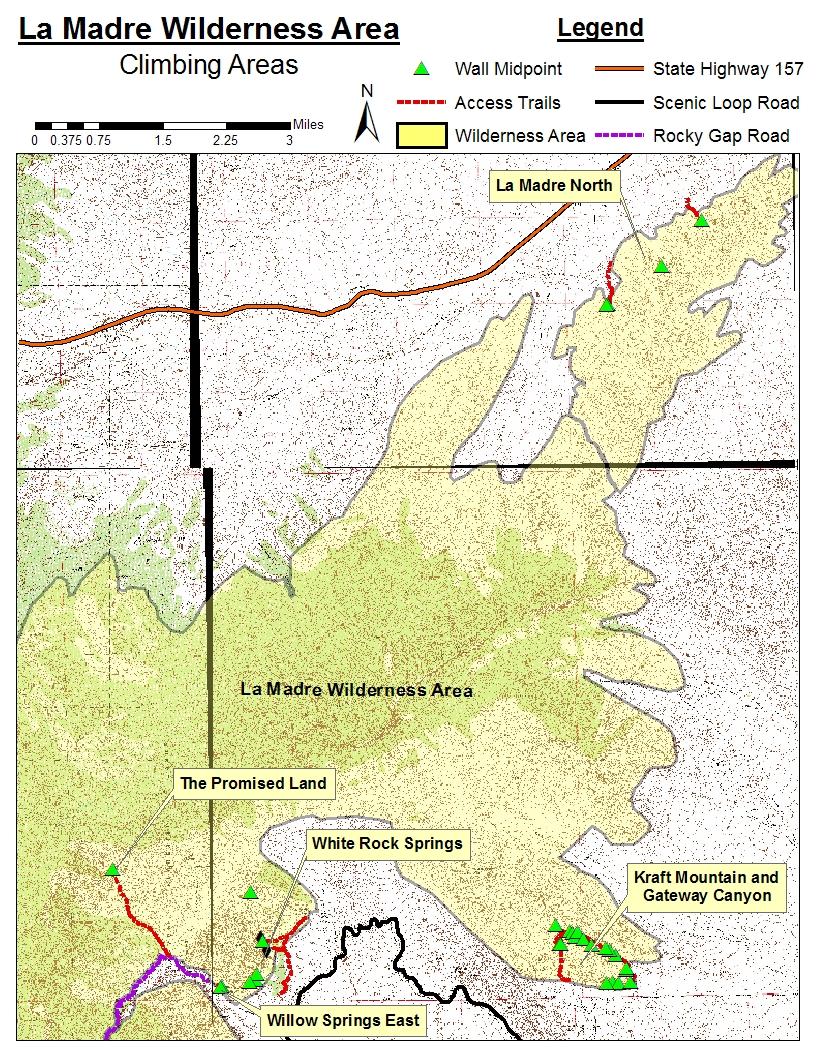
1 La Madre Wilderness Area Rock Climbing Inventory Statistics: Area: Walls La Madre North Kraft Mt./Gateway Canyon White Rock Springs Willow Springs East The Promised Land TOTAL: /184 routes field verified 9% 7 new routes not found in literature Route information and locations were identified based upon information gathered from and all six guidebooks: Islands in the Sky, Las Vegas Limestone, Red Rock Canyon: A Climbing Guide, Rock Climbing: Red Rocks, Red Rocks Climbing, and Red Rock Odyssey. Six new routes were discovered that were not mentioned in the literature review. This included one fixed line that provided access to the Upper Ledge of The Promised Land. The climbs at the Angel Food Wall (White Rock Springs) and at White Rock Springs Peak were not field verifiable for bolt and anchor counts. Also, hardware data for two routes at Kraft Rocks Upper Tier and The Cave (The Promised Land) was not able to be field verified from the ground. Hardware data was collected and verified by field observations for all of the remaining climbs in the La Madre Wilderness Area.
2
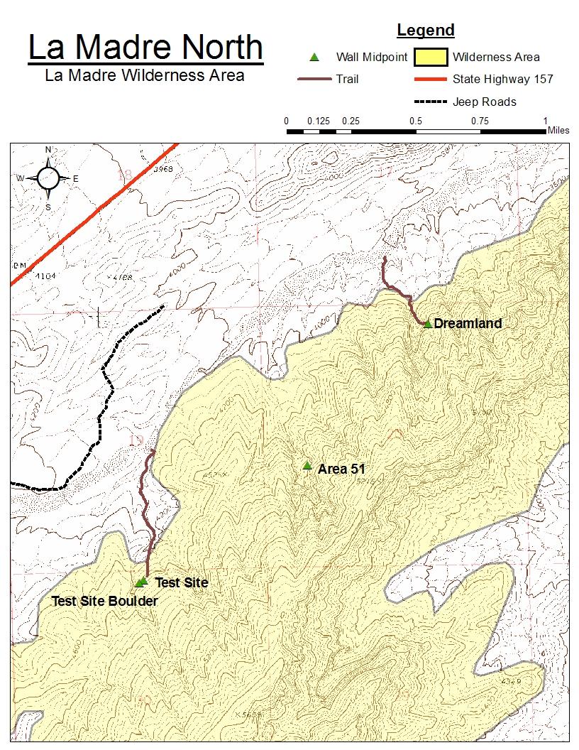
3 LaMadre North Rock climbing inventory statistics: Wall: # of # of # of Test Site Area Dreamland TOTAL: /24 routes field verified 1% 1 new route not found in literature. Route information and locations were identified based upon information gathered from the Islands in the Sky (pgs ) climbing guide. Exact bolt and anchor counts were obtained for all routes by field survey.
4


5 Access: La Madre North To reach the climbing areas at La Madre North a four-wheel drive vehicle with good clearance is recommended. Drive down Hwy. 157 approximately 7 miles until you reach a left turn just past Scottie Street on the right. Take this dirt road until it turns into a 4x4 road that parallels a wash. Continue on the 4x4 road until a steep track leads you down into the wash. Follow the wash to the northeast for about 2 miles to a narrow section next to another wash that branches out to the south. This is the access to the Test Site. Reach the crag by hiking up the wash and meandering over desert terrain to the prominent cliff band to the southeast. Approximately.25 miles past this point is another side gully (fig. 1) leading to the south. Follow this branch up and into a series of canyons to reach Area 51. Finally,.5 miles further down the main wash is a pair of gullies that allow access to Dreamland. Hike up the gully on the right a short ways before scrambling up and onto flat desert terrain. Head for the cave set back into the hillside to the south. Fig. 1 (left): Side gully accessing Area 51. The climbing is found by hiking up the wash in the foreground to the lowest branch of the canyon seen in the middle of the picture. Fig. 2 (right): Access to Dreamland is up the gully to the right. The steeper gully to the right turns into a box canyon. Dreamland is the dark cave in the center of the picture between the two gullies.
: This long wall can be seen in the distance from the")


6 Test Site: La Madre North Fig. 1 (below): This long wall can be seen in the distance from the wash where you park. Hike up a gully from the main wash and then continue across desert terrain until you reach the wall new route not found in literature Test Site Boulder: Fig. 2 (left): This boulder has one route on it and is located just below the main Test Site wall at the far southwest end.
: This large area is found in a series of canyons that can be")

: This cave is the last crag at the northeast end of the")
7 Area 51: La Madre North Fig. 1 (below): This large area is found in a series of canyons that can be viewed from the main wash to the northeast of Test Site. More climbs can be found around and up to the right of this picture. A raptor nest was discovered at this crag Dreamland: Fig. 2 (below/left): This cave is the last crag at the northeast end of the La Madre North area and can just barely be seen from the main wash
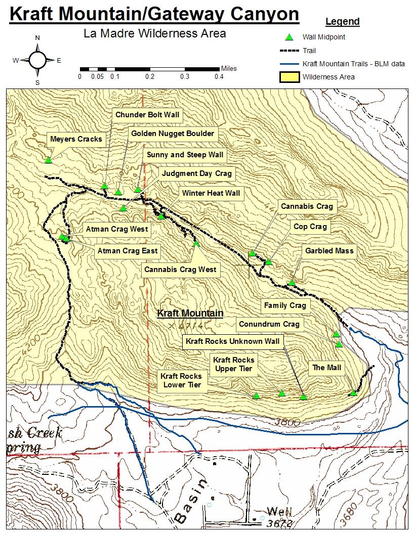
8 Kraft Mountain and Gateway Canyon Rock Climbing Inventory Statistics: Wall: # of # of # of Kraft Rocks Lower Tier 5 1 Kraft Rocks Upper Tier Kraft Rocks Unknown Wall 4 2 The Mall (The Playground) Conundrum Crag Family Crag The Garbled Mass (Swirly Cliff) 1 Cop Crag (Swirly Cliff) Cannabis Crag Cannabis Crag West 2 Winter Heat Wall Sunny and Steep Wall Golden Nugget Boulder Judgment Day Crag Chunder Bolt Wall Atman Crag East 3 Atman Crag West 4 Meyers Cracks 2 TOTAL: /12 routes field verified 98% 4 new routes not found in literature Route information and locations were identified based upon information gathered from Red Rock Canyon: A Climbing Guide (pgs ), and Rock Climbing: Red Rocks (pgs ). Exact bolt and anchor counts were verified for all routes with the exception of the Kraft Rocks upper tier anchor on routes Weasel Yeast and Weasel Cheese.
9


10 Kraft Mountain and Gateway Canyon Areas Access: Kraft Mountain and Gateway canyon are located on the northeast side of Calico Basin. Drive west from Las Vegas on Charleston Blvd, which turns into State Highway 159, and turn right on Calico Basin Road about 2 miles before the access to the Scenic Loop Road. Follow this road as it winds around to the left and then right up to a parking lot about 1.1 miles from the highway. The parking area is at a cul-de-sac at the end of Sandstone Drive. You will see an empty, fenced-in lot on the left and a fenced-in field behind a house on your right. Hike down the trail dividing the empty lot and the field until you cross a large wash. Keep your eyes peeled for trails heading east or west around Kraft Mountain. Follow these trails to access the climbs on Kraft Mountain and Gateway Canyon.
: The Lower Tier of Kraft Rocks is directly in front of you as you")
 shown in")
: The Upper Tier of Kraft Rocks is located up and to the")
11 Kraft Mountain Kraft Rocks Lower Tier: Fig. 1 (right): The Lower Tier of Kraft Rocks is directly in front of you as you hike towards Kraft Mountain from the parking area. The climbs are above the split boulder (Plumber s Crack Boulder) shown in the foreground. 5 1 Kraft Rocks Upper Tier: Fig. 2 (below/right): The Upper Tier of Kraft Rocks is located up and to the right of the Lower Tier as you move East along Kraft Mountain % field verified
: These climbs are further to the East along Kraft Mountain from the Upper Tier.")
: Another part of the Unknown Wall at Kraft Rocks.")
12 Kraft Mountain new routes not found in literature Kraft Rocks Unknown Wall: Fig. 1 (above): These climbs are further to the East along Kraft Mountain from the Upper Tier. The wall pictured above is South facing and hold two unknown mixed routes. Fig. 2 (right): Another part of the Unknown Wall at Kraft Rocks. This left facing corner holds two unknown trad routes.
: Also known as the Playground, this wall is located at the")

: The Conundrum crag, with several sport and mixed routes, is")
13 Kraft Mountain The Mall: Fig. 1 (above): Also known as the Playground, this wall is located at the far East end of Kraft Mountain. Climbs are located on both the upper ledge and at ground level Conundrum Crag: Fig. 2 (right): The Conundrum crag, with several sport and mixed routes, is located on the back (North) side of Kraft Mountain. Hike around from The Mall until just before entering Gateway Canyon
: The Family Crag is just north of")


14 Kraft Mountain Family Crag: Fig. 1 (right): The Family Crag is just north of Conundrum Crag on the back side of Kraft Mountain Fig. 2 (right): From the Family Crag one must use this trail to access the east entrance of Gateway Canyon. The Garbled Mass is just visible in the middle of the scene.
: The Garbled Mass is the first crag you come to as you travel west through Gateway Canyon.")

15 Gateway Canyon The Garbled Mass: Fig. 1 (above): The Garbled Mass is the first crag you come to as you travel west through Gateway Canyon. It is on the north side, to the right as you approach, and makes up the east end of the Swirly Cliff area. 1 Cop Crag: Fig. 2 (right): The Cop Crag (central Swirly Cliff area) is just to the west of the Garbled Mass as you move deeper into Gateway Canyon
: The Cannabis Crag, with 1 sport")

: Cannabis Crag West is located on the")

16 Gateway Canyon Cannabis Crag: Fig. 1 (left/below): The Cannabis Crag, with 1 sport routes, is past the Cop Crag on the north side of Gateway Canyon as you move further west Cannabis Crag West: Fig. 2 (right): Cannabis Crag West is located on the south side of Gateway Canyon directly across from the Cannabis Crag. It is difficult to find having only two traditional routes. 2
: As you continue into Gateway Canyon from the east it narrows and")

: Sunny and Steep Wall is located just west of Winter Heat Wall on")
17 Gateway Canyon Northwest Winter Heat Wall: Fig. 1 (above): As you continue into Gateway Canyon from the east it narrows and becomes choked off by scrub oak and boulders. Past this, when the canyon opens up again, you will find the Winter Heat Wall on the south side of the canyon Sunny and Steep Wall: Fig. 2 (right): Sunny and Steep Wall is located just west of Winter Heat Wall on the north side of the canyon. It has 16 sport routes of all difficulties

18 Gateway Canyon Northwest Golden Nugget Boulder: Fig. 1 (above): This feature is to the west of Sunny and Steep Wall at approximately the same level above the canyon floor. It is possible to access both areas from the wash or traverse between them along easy slabs and ledges Judgment Day Crag: Fig. 2 (right): Judgment Day Crag is on the south side of Gateway Canyon to the west and across from the Golden Nugget Boulder. Scramble up slabs to reach the climbs
: This wall has one sport route and is located at the west end of Gateway Canyon as it opens up behind Kraft Mountain.")
: At the west end of Gateway Canyon this trail enters the wash from above.")
19 Gateway Canyon Northwest Chunder Bolt Wall: Fig. 1 (right): This wall has one sport route and is located at the west end of Gateway Canyon as it opens up behind Kraft Mountain. It rises over the floor of the wash on the north side of the canyon Fig. 2 (left): At the west end of Gateway Canyon this trail enters the wash from above. This trail accesses climbs along Kraft Mountain s west end and eventually loops around to the parking area. It s a bit of a drop to the floor of the wash, but the trail is more moderate as you move up and around Kraft Mountain.

20 Gateway Canyon Northwest Atman Crag East: Fig. 1 (right): The east side of Atman Crag has routes climbing these smooth faces and cracks. This climber is at the top of Ying Yang Crack. Climbs are accessed by hiking up from Gateway Canyon below or circling around from the Kraft Mountain Trail to the West. 3 4 Atman Crag West: Fig. 2 (right): Atman Crag West is at the west end of Kraft Mountain and is easily accessible from the Kraft Mountain Trail as you pass by before going down into Gateway Canyon.
: The Meyer s Cracks are")


21 Gateway Canyon Northwest Meyer s Crack: Fig. 1 (above): The Meyer s Cracks are two lesser known traditional climbs on the north side of Gateway Canyon, at the very west end past Kraft Mountain. The canyon continues west and north as it becomes less defined. The climbs are just before the canyon opens up and veers to the north. 2
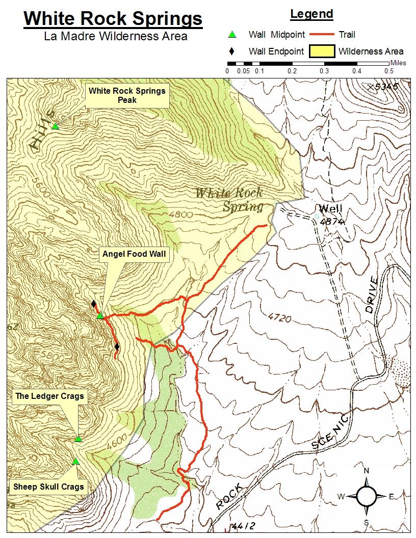
22 White Rock Springs Rock Climbing Inventory Statistics: Wall: # of # of # of Angel Food Wall White Rock Springs Peak 1 Sheep Skull Crag The Ledger Crags 2 TOTAL: /23 routes field verified 43% 2 new routes not found in literature Route information and locations were identified based upon information gathered from Red Rock Canyon: A Climbing Guide (pgs ), Rock Climbing: Red Rocks (pgs ), Red Rocks Climbing (pgs ), Red Rock Odyssey (pgs ) and Exact bolt and anchor counts were verified for all routes on the Sheep Skull and Ledger Crags. However, the Angel Food Wall and White Rock Springs Peak climbs were not entirely visible from the ground. Therefore, an accurate hardware count was not possible.
23

24 White Rock Springs Access: Take the Scenic Loop Road from the BLM Visitor s Center for approximately 5.8 miles until you see a right hand turn for White Rock Springs. Follow the gravel road to the end and park. The Angel Food Wall will be to your left and is the dominant feature on the escarpment in front of you. It looks like tall pillars of white cake-like rock. The picture below shows the best trail to access the Angel Food Wall. Sheep Skull Crags and Ledger Crags are further to the south along the cliff and are reached by hiking along the Willow Springs Trail toward Willow Springs.


25 White Rock Springs % field verified Angel Food Wall: Fig. 1 (above): White Rock Springs main attraction is the Angel food Wall pictured above. To access this wall hike west from the parking area to reach the Willow Springs Trail. Turn left (south) and continue until you see the trail pictured on the previous page. This trail will take you straight to the wall after some light scrambling up the approach slope. White Rock Springs Peak: Fig. 2 (right): This peak is visible to the west from the parking area. Take a bearing and start hiking. The approach is up a moderate slope and takes a little over an hour. 1 % field verified
: Continue south on the Willow Springs Trail about 2 minutes past the access trail for the Angel Food Wall.")
26 8 White Rock Springs 5 2 new routes not found in literature 3 Sheep Skull Crags: Fig. 1 (above): Continue south on the Willow Springs Trail about 2 minutes past the access trail for the Angel Food Wall. Look for this east facing wall to your right just past a gully separating Sheep Skull Crags from the Ledger Crags. Take a faint path up to the base of the wall. Ledger Crags: Fig. 2 (right): The Ledger Crags are across the gully to the north from Sheep Skull Crags. There are two good, but relatively overlooked, traditional routes here. 2
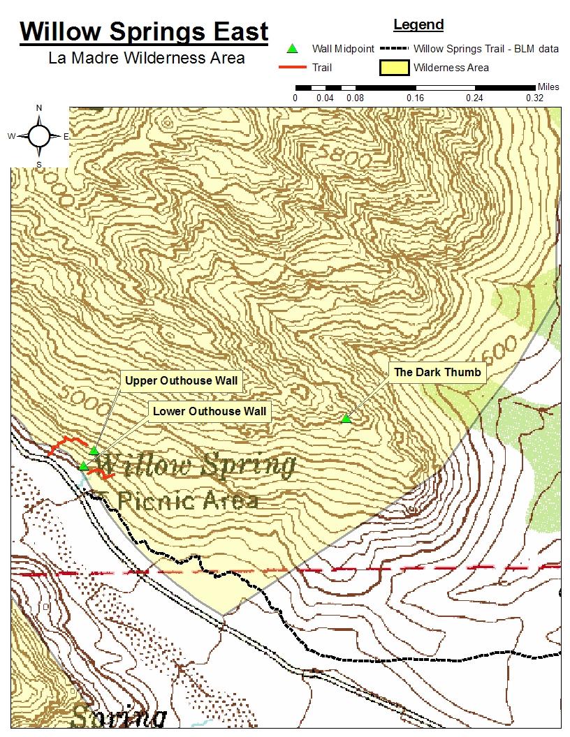
27 Willow Springs East Rock climbing inventory statistics: Wall: # of # of # of Upper Outhouse Wall 3 Lower Outhouse Wall 6 The Dark Thumb TOTAL: /11 routes field verified 1% Route information and locations were identified based upon information gathered from Red Rock Canyon: A Climbing Guide (pgs ). Exact bolt and anchor counts were verified for all routes in Willow Springs East. Access: Take the Scenic Loop Road from the BLM Visitor s Center for approximately 7.3 miles until you see a right hand turn for Willow Springs. Take the road to a picnic area at the end and park. The Outhouse Walls are directly behind the picnic/spring area and are easily accessible by a short walk from the car. The Lower Wall is at ground level directly behind the bathroom and picnic tables. The Upper Wall requires a short walk north past the picnic area to a spot where you can scramble up to the ledges above. Traverse back along the ledges until you reach the climbs. The Dark Thumb is accessed by hiking the Willow Springs Trail east from the Hidden Falls/Lost Creek parking area. Once the red dirt trail turns to brown branch off the main trail and head up to the distinct pillar known as the Owl. From the Owl head straight north up the slope to reach the Dark Thumb.
28

: This feature can be accessed from the Willow Springs Trail. Head southeast from the parking area uphill until the red dirt trail turns to brown.")
29 Outhouse Walls: Fig. 1 (above): The Upper and Lower Outhouse Walls are located directly behind and above the picnic/spring area seen here. The lower band of huecoed rock behind the trees make up the Lower Outhouse Wall. The three climbs of the Upper Outhouse Wall can be found in the whitish rock in the upper portion of the photo. 9 Willow Springs East The Dark Thumb: Fig. 2 (right): This feature can be accessed from the Willow Springs Trail. Head southeast from the parking area uphill until the red dirt trail turns to brown. Turn off of the main trail and head up toward a distinct pillar known as the Owl. From there turn left (north) to scramble up the final approach
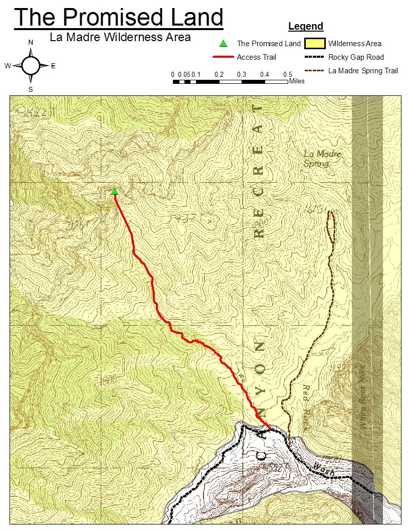
30 The Promised Land Rock climbing inventory statistics: Wall: # of # of # of The Cave Upper Ledge Lower Ledge TOTAL: /24 routes field verified 91% Route information and locations were identified based upon information gathered from Islands in the Sky (pgs ) and Las Vegas Limestone (pgs ) climbing guides. Exact bolt and anchor counts were obtained for all routes by field survey with the exception of two unknown projects that did not appear to have bolts within visible range. This inventory includes a fixed rope that accesses the Upper Ledge from the Lower Ledge. It also includes 3 bolts at the base of the ledge that appear to be used as belay anchors for the climbs on Upper Ledge.
31


 until you find yourself down in a wash.")
: The old 4x4 road starts at signs for the Wilderness Area boundary from the Rocky")
32 Access: The Promised Land The Promised Land is accessed by driving up the Rocky Gap Road until you see an old 4x4 road split off to the right past some boulders and signs identifying the land beyond as wilderness area (fig. 1). Hike up the old 4x4 road until it veers sharply left and up a slope. Take the trail that splits off to the right (fig. 2) until you find yourself down in a wash. Hike up the wash approximately 1 km to the base of The Promised Land. Fig. 1 (left): The old 4x4 road starts at signs for the Wilderness Area boundary from the Rocky Gap Road. Fig. 2 (right): Trail branching off from the old 4x4 road. Start between the two dead trees and continue down into the wash that accesses The Promised Land.
: The Promised Land is made up")

: Fixed rope allowing access")
33 The Promised Land Fig. 1 (above): The Promised Land is made up by The Cave to the left and the Upper and Lower Ledges to the right % field verified 14 Fig. 2 (right): Fixed rope allowing access from the Lower Ledge to the Upper Ledge.
Approach. Via Stewart Creek Three Sisters
 three sisters The Three Sisters are a signature landmark for the Bow Valley and the town of Canmore. They may even compete with Mount Rundle above Banff as the most photographed and painted mountain scene
Darrington Rock Climbing Sampler. Page 1. a mini-guide to some routes in Clear and Copper Creeks
 a mini-guide to some routes in Clear and Copper Creeks Joe near the top of Exfoliation Dome. Near Darrington, Washington, there are several granite domes in scenic mountain valleys. This is not sport climbing:
Bankhead Buttress (incomplete)
") Bankhead Buttress (incomplete) This section of cliff is the most extensive of all the buttresses in the long line of cliffs that runs along the base of Cascade Mountain. It reaches a height of ---m and
Bankhead Buttress (incomplete) This section of cliff is the most extensive of all the buttresses in the long line of cliffs that runs along the base of Cascade Mountain. It reaches a height of ---m and
Mount Cory South Peak, West Face
 Mount Cory South Peak, West Face These climbs are adjacent to the climb Cory Crack and combine a relatively short approach (~1 hr.) through forest and meadows with long multi-pitch routes on generally
SHIP S PROW. Access. Approach #1 from Peaks of Grassi. Approach #2 via Three Sisters Creek. Ship s Prow - 309
 SHIP S PROW Ship s Prow is the very prominent, sharp buttress between The Three Sisters and Ha Ling Peak. It has a large, steep face on its northwest side and is about 450 m high. To date, only two routes
This area receives morning and mid-day sun and nice shade by early afternoon.
 Quartzite Wasteland The name, Quartzite Wasteland, is a playful jab at the the Wasteland of Rifle. While not a destination area like Rifle, locals and visiting climbers will find an enjoyable half-day
You are responsible for you own safety. You climb at your own risk!!!
 Warning You are responsible for you own safety. You climb at your own risk!!! This is also a new climbing area; while great effort has been made to clean any loose rock through pry bar and pressure washing,
McGILLIVRAY SLABS. Approach. Descent. Gollywog 240 m, 5.7 R. Howe & C. Smith, McGillivray Slabs - 277
 McGILLIVRAY SLABS The Palliser Formation outcrops on Mount McGillivray in a long line of cliffs punctuated by several buttresses. All the climbs described here lie on McGillivray Slabs, the portion of
Eardley Canyon, Straight Wash San Rafael Swell, Central Swell
 Eardley Canyon, Straight Wash San Rafael Swell, Central Swell Rating: Best Season: Time: Access: Permit: Equipment: Map: Cold Protection: Drinking Water: Flash Flood Risk: Skills Required: Technical Note:
Wentworth Falls Conservation Hut Loop
 Wentworth Falls Conservation Hut Loop 3 hrs Hard track 6.7 km Circuit 4 341m This scenic walk from Wentworth Falls Station, winds along the Nature Trail to Conservation Hut, then drops into the magnificent
You are responsible for you own safety. You climb at your own risk!!!
 Paradise Topo v1.1 May 8, 2018 Warning You are responsible for you own safety. You climb at your own risk!!! This is also a new climbing area; while great effort has been made to clean any loose rock through
Utah. North Stansbury Mountains Wilderness Study Area Site-Specific Monitoring Guide
 Utah North Stansbury Mountains Wilderness Study Area Site-Specific Monitoring Guide 1 General Information WildSNAP Monitoring Peter Woodruff, American Conservation Experience Coordinator Phone (801) 989-7069
NANNY GOAT. Approach. Kid Goat Approach. Meadows Approach. 52 Goat Mountain
 NANNY GOAT Nanny Goat is steeper and less broken than Kid Goat and generally the climbs are more difficult. The quality of the rock is quite variable and the routes, which consist primarily of face climbing,
Gallow s Edge. Miniguide
 Gallows Edge Miniguide 1 Gallow s Edge Miniguide The majority of this downloadable miniguide was copied from Walt Wehners excellent website at: http://www.geocities.com/yosemite/trails/9507/gallowsedge.htm.
Queen Creek Canyon. Guidebooks The Rock Jocks Guide to Queens Creek Canyon by Marty Karabin Jr.
 is one of Arizona s best winter climbing destination. The area is about 1 1/2 hours east of hoenix and elevation is around 4000 feet. The rock is a thick formation of ash that was deposited between 15
New Routes and description to re-bolted (ENP) routes on the Puig Campana.
 routes on the Puig Campana.") New Routes and description to re-bolted (ENP) routes on the Puig Campana. This magnificent mountain dominates most of the coast of the Costa Blanca with its twin peaks and distinctive notch. Seen from
New Routes and description to re-bolted (ENP) routes on the Puig Campana. This magnificent mountain dominates most of the coast of the Costa Blanca with its twin peaks and distinctive notch. Seen from
Fish Lake Team Relay Course Information 2016
 Fish Lake Team Relay Course Information 2016 Fish Lake Team Relay Course Information 2016 The Fish Lake Team Relay begins at Fish Lake Lodge on the shores of beautiful Fish Lake located in Sevier County,
The Tuross River plunges 40m into the gorge
 is a new area in terms of climbing and just 2 hours drive from Canberra. The falls are located in the Wadbilliga State Forest. Free camping with fireplaces and picnic tables make weekend expeditions a
Kid Goat. Approach. 28 Goat Mountain
 Kid Goat Kid Goat is the smallest and most developed of the Goat Mountain climbing areas and is about 150 m high. It consists of predominantly low-angled rock with a steeper band at just over half height
RockTopos. Rock Climbing Guide Costa Blanca Rincon de Bonanza. RockTopos. Rincon de Bonanza
 climbing guides are intended to provide documented information, directions and route descriptions for the rock climbing at the cliff or area covered by the guide. The guides are intended to supplement
Fedw Fawr. Photo: Andy Godber on Lurcher Direct 6B+ Si Panton
 Fedw Fawr At the western end of the Fedw Fawr sport crag there are two bays at the base of the sea cliff which offer a suite of excellent burly boulder problems on perfect limestone with unspoilt horizon-searching
Haunted Walls. Approach to Pleasure Domes, Haunted Walls and Ajuga Pilar ( Cynical Pinnacle).
.") Haunted Walls. This dramatic area has several powerful lines on Perfect rock. As its name implies it does have a haunted and magical feel to it, so silent and peaceful. On first sight it is jaw dropping.
Haunted Walls. This dramatic area has several powerful lines on Perfect rock. As its name implies it does have a haunted and magical feel to it, so silent and peaceful. On first sight it is jaw dropping.
TELLURIDE SOUTH. Telluride. Waterfall Chute. Yellow Brick Wall. Bear Creek. Falls. Fairview Wall. Wasatch Trail Wall. Rock of Ages.
 TELLURIDE SOUTH Wasatch Trail #508 Yellow Brick Wall OZ Fairview Wall Waterfall Chute Rock of Ages Mine Entrance Falls Rock of Ages creek Wasatch Trail Wall Sesame Street Climbs Wasatch FS 635 Rd Needle
Fish Lake Team Relay Course Information
 Fish Lake Team Relay Course Information Fish Lake Team Relay Course Information The Fish Lake Team Relay begins at Fish Lake Lodge on the shores of beautiful Fish Lake located in Sevier County, Utah. The
A Guide to Unicorn Canyon Peter Nelson, Craig Doram Zak McGurk cruising the second ascent of Money Jane
 A Guide to Unicorn Canyon Peter Nelson, Craig Doram Zak McGurk cruising the second ascent of Money Jane P a g e 2 Table of Contents Introduction... 2 Getting There... 2 Climbing Area Descriptions... 5
Hornsby Blue Gum Walk
 Hornsby Blue Gum Walk 3 hrs Hard track 6.7 km Circuit 4 374m This delightful loop is one of the prettiest and most popular walks in the Hornsby area. Going from an environment of ferns and clear bushland
Gooseberry Area. Gooseberry 250 m, 5.8 Ken Baker and Lloyd MacKay, May 1967 Joe Mackay, alt. pitch 5.
 Gooseberry Area Gooseberry 250 m, 5.8 Ken Baker and Lloyd MacKay, May 1967 Joe Mackay, alt. pitch 5. This classic route is superbly situated on the east side of Tunnel Mountain with excellent views of
Coyote Buttes/The Waves
 Coyote Buttes/The Waves Ron Ross December 22, 2007 Coyote Buttes is located in the Paria Canyon-Vermilion Cliffs Wilderness just south of US 89 about halfway between Kanab, Utah and Page, Arizona. The
ANSWER SHEET PART 4 EXPERT LAND NAVIGATION
 ANSWER SHEET PART 4 EXPERT LAND NAVIGATION 1. Knowing these four basic skills, it is impossible to be totally lost; what are they? a. Track Present Location / Determine Distance / Sense of Direction /
Rock Climbing in Kowloon, Qing Yuan County, Guangdong, PRC
 Rock Climbing in Kowloon, Qing Yuan County, Guangdong, PRC The following notes, maps and topos form a rough guide to most of the established climbing in the Kowloon (Nine Dragons) area of Qing Yuan County,
The French Pillar of Jebel Misht
 Rock climbing in the UAE Oman Misht The French Pillar of and Jebel a climbing guide The French Pillar of Jebel Misht v1.0, February 2007 1 Toby Foord-Kelcey, February 2007 Disclaimer Climbing is a sport
WILGEPOORT Sport Crag
 WILGEPOORT Sport Crag General Wilgepoort has been a firm favorite with a small but enthusiastic number of traditional climbers from the Pretoria/Johannesburg area since its discovery in 1966. The main
FROG ROCK EAST FACE PAGE 1
 FROG ROCK EAST FACE Anchors for crux notch traverse on Frogback Jabba s Jingus Joyride 5.9 (no anchor yet) Start of Frogback Traverse Approach Do)ed line indicates gully behind forma,on in foreground Alternate
Wentworth Falls Station Loop (Undercliff Walk)
") Wentworth Falls Station Loop (Undercliff Walk) 4 hrs 3 mins Hard track 8.9 km Circuit 658m 4 This walk passes some stunning waterfalls and views into the Jamison Valley, following the cliff edges around
Wentworth Falls Station Loop (Undercliff Walk) 4 hrs 3 mins Hard track 8.9 km Circuit 658m 4 This walk passes some stunning waterfalls and views into the Jamison Valley, following the cliff edges around
Black Crag. Francis Haden and Rich Cuncliffe
 Black Crag Overview Black Crag is an easily accessible south-facing cliff of enjoyable HK island broken-slab climbing with a fantastic view out over the south of the island. It is two hundred metres below
Pah Rah Mountain Range
 Pah Rah Mountain Range The Pah Rah Mountain Range is located east of the city of Sparks, and parallels Vista Boulevard. The mountain range originates at Interstate 80, and terminates at Pyramid Lake. Most
Glen Lake Crag. The Glen Lake crag offers relatively easy access, close proximity to Greater Victoria, and caters to
 Glen Lake Crag Introduction The Glen Lake crag offers relatively easy access, close proximity to Greater Victoria, and caters to beginner and intermediate climbers with routes ranging from 5.7-5.11-, from
SPORT CLIMBS HORI BAY. OCTOBER 2014 EDITION Climbing near Nelson, New Zealand
 SPORT CLIMBS HORI BAY OCTOBER 2014 EDITION Climbing near Nelson, New Zealand Another day at Hori Bay Hori Bay, New Zealand Sectors 1 The Arena The Sideshow 2 3 5 6 8 WARNING! Climbing is a potentially
Climbing is a sport which can result in serious injury or death. Read the advice below before you climb using this guide.
 Scorpion Buttress Wadi Maih Climbing Guide Ray Corbett, December 2008 1 WARNING ABOUT ROCK CLIMBING Climbing is a sport which can result in serious injury or death. Read the advice below before you climb
Wildhorse Classics. Pat McGrane November 20, 2014
 Wildhorse Classics Pat McGrane November 20, 2014 This document describes some of the classic technical rock climbs in the eastern Pioneer Range of Idaho. It includes routes in Wildhorse Basin as well as
RockTopos Climbing Guide Costa Blanca. Segaria-Autopista
 RockTopo climbing guides are intended to provide documented information, directions and routes descriptions for the rock climbing at the cliff or area covered by the guide. The guides are intended to supplement
The Seven Pillars of Wisdom Storm Tower Wind and Flurry * 5.8, 28 m, fixed gear Snowflakes of August **5.11b, 28 m, fixed gear
 The Seven Pillars of Wisdom A collection of shattered pillars which lie in front of the Grey Ghost Wall towards the left end between the climbs Helmet Crack and Zephyr and are separated from the main face
Rogues Gallery Bouldering
 Rogues Gallery Bouldering Rogues Gallery is located half way between Squamish and Whistler on the right side of the highway which is 30kms from the Squamish McDonalds. The bouldering area lies on the ridge
Calaveras Big Trees State Park--South Grove Loop
 Copyright 1999 by Jeff Robinson. You are free to use and reproduce this description for personal, not-for-profit, and not-forbusiness use. Any reproduction other than for personal use, including businesses,
TOKOPAH DOMES. SEKIclimbing.com
 TOKOPAH DOMES Intro Tokopah Domes are the orphaned offspring of a dome from Tuolumne and a mischievous peak from Shuteye Ridge. They are covered in knobs, chicken heads, and runnels with a few cracks and
Campbell Drive to Snapper Point
 Campbell Drive to Snapper Point 1 hr 45 mins 4.2 km One way Experienced only 135m This walk follows the Coast Track to Frazer Beach, along the Geebung and (overgrown) Grass Tree Tracks. From the northern
Climbing Management Plan Goals: Climber Safety All climbers are strongly
 Climbing Management Plan Goals: 1. Preserve the natural resources found at Hidden Valley while providing for recreational climbing activities. 2. Present a clearly defined set of regulations for climbing
Bakewell Club Site - Robin Hood's Stride
 Bakewell Club Site - Robin Hood's Stride Camping and Caravanning Route Summary A circular walk with fabulous views winding it's way through the beautiful White Peak scenery. Points of interest include
WATERFALL ROCK. Page 110. Hong Kong Climbing- The Columnar Jointing that makes Waterfall Rocks so special Photo: Stuart Millis HongKongClimbing.
 Hong Kong Climbing- WATERFALL ROCK The Columnar Jointing that makes Waterfall Rocks so special Photo: Stuart Millis Page 110 General Waterfall Rock The crag is formed by columnar jointing of volcanic tuff,
South-west facing crag, exclusively with naturally protected lines. The rock quality is good and the lines dry quickly.
 The Lutsi cliff South-west facing crag, exclusively with naturally protected lines. The rock quality is good and the lines dry quickly. So far there are 24 recorded routes with grades ranging from 5 to
They have cabins and camping with a large camp kitchen equipped with stoves, fridge, microwave and BBQ. Why go anywhere else?
 ABOUT Mt Trio is situated in the Stirling Ranges which is typically known for multi pitch adventures. This crag offers quality bolted climbing with most routes being steep and long, whilst being in a stunning
Las Conchas Climbing Guide for Cattle Call Wall and Gateway Rock. Jemez Mountains, New Mexico
 Las Conchas Climbing Guide for Cattle Call Wall and Gateway Rock Jemez Mountains, New Mexico Jason Halladay halladay@gmail.com Last updated 30 August 2007 Cattle Call Wall With its thirty-second approach
Black Hills, South Dakota, June 2017
 Black Hills, South Dakota, June 2017 Greetings! We just returned from a five day rock climbing trip in the Black Hills of South Dakotahere's our trip report. Day 0 We decided to split the 14 hour drive
Leg #1 (GUNLOCK AND LOADED) Miles
 Miles") Leg #1 (GUNLOCK AND LOADED)- 6.07 Miles Difficulty: Easy to Moderate This is a nice leg for those who like running downhill. It s a beautiful run down the Santa Clara River canyon to the point where the
Leg #1 (GUNLOCK AND LOADED)- 6.07 Miles Difficulty: Easy to Moderate This is a nice leg for those who like running downhill. It s a beautiful run down the Santa Clara River canyon to the point where the
Popes Glen, Pulpit Rock, Govetts Leap and Braeside Walk
 Popes Glen, Pulpit Rock, Govetts Leap and Braeside Walk 8 hrs Hard track 13.6 km Circuit 4 1068m This large circuit walk, from Popes Glen to Pulpit Rock, Govetts leap and along the Braeside Track, passes
Conceptual Rock Climbing Plan City of Scottsdale - McDowell Sonoran Preserve
 CLIMBING GUIDELINES: Conceptual Rock Climbing Plan City of Scottsdale - McDowell Sonoran Preserve Background The McDowell Sonoran Preserve has been acquired by the City of Scottsdale to preserve and protect
USING THE MILITARY LENSATIC COMPASS
 USING THE MILITARY LENSATIC COMPASS WARNING This presentation is intended as a quick summary, and not a comprehensive resource. If you want to learn Land Navigation in detail, either buy a book; or get
Some routes on Mt Banks
 Friends don t let friends place Friends 24 Weakened worriers 23 Some routes on Mt Banks Zanahoria Pestosterone Tricycle To Bell s line of road Gate Cliffs Summit of Mt Banks About 60 minutes walk or 15
Mackerel Beach, West Head Loop
 Mackerel Beach, West Head Loop 5 hrs 8.6 km Circuit Hard track 422m The Mackerel Beach, West Head Loop is a walk which explores a large part of the West Head. The journey starts and finishes with a ferry
Wentworth Falls Station Loop
 Wentworth Falls Station Loop 5 hrs 3 mins 9.5 km Circuit Hard track 4 13m The Wentworth Falls Station Loop takes in most of the upper tracks around Wentworth Falls. There are many scenic views near the
High Uinta Wilderness
 High Uinta Wilderness July 5-7, 2010 Elevation: 10,000 11,000 Grayling, Brook, Cutthroat It was that time of year again to do my annual backpacking/fly fishing trip with my brothers. This year my brothers
Under and Over Cliff Walk
 Under and Over Cliff Walk 4 hrs 9.4 km Circuit Moderate track 576m This walk from Wentworth Falls Station is a fantastic way to see a large majority of the Wentworth Falls cliffline. The track winds under
Scenic World to Echo Point
 Scenic World to Echo Point 1 hr 15 mins 2.1 km One way Moderate track 192m This is one of the most popular tourist walks in the Katoomba area. The walk follows the cliffs along a well maintained and signposted
Echo Point to Leura Forest via Three Sisters and Giant Stairs loop
 Echo Point to Leura Forest via Three Sisters and Giant Stairs loop 3 hrs 3.8 km Circuit Hard track 512m This walk starts from the popular Echo Point, in Katoomba, and winds down to the base of the Three
RockTopos Climbing Guide Costa Blanca. L Ocaive. A free climbing guide provided by RockTopos Published 2006
 RockTopo climbing guides are intended to provide documented information, directions and routes descriptions for the rock climbing at the cliff or area covered by the guide. The guides are intended to supplement
Canoe Trip # Length of Trip: 225 kilometres Time Required to Complete Trip: 10 to 14 days Number of Portages: 21 to 25
 Canoe Trip #34 34 Brabant Lake - Wapiskau River - Steephill Lake - Reindeer River - Churchill River - Sandy Bay 225 Kilometers - 10 to 14 days - 21 to 25 portages Length of Trip: 225 kilometres Time Required
The Lake Creek Ranch. Located in the foothills of the Owl Creek Mountains in western Hot Springs County, Wyoming
 The Lake Creek Ranch Located in the foothills of the Owl Creek Mountains in western Hot Springs County, Wyoming Experienced Professional Ranch Brokers Specializing in the sale of ranches, farms, & recreational
Mackerel Beach and Resolute Loop
 Mackerel Beach and Resolute Loop 3 hrs 5.4 km Circuit Hard track 384m This walk is another great walk in Ku-ring-gai Chase National Park, accessed by ferry. From the Mackerel Beach wharf, this walk uses
Pre-Application Document Kaweah Project (FERC Project No. 298)
") TABLE OF CONTENTS Page 3.12 Aesthetic Resources... 3.12-1 3.12.1 Information Sources... 3.12-1 3.12.2 Setting... 3.12-1 3.12.3 Project Facilities... 3.12-2 3.12.4 Previous Visual Resources Assessment...
TABLE OF CONTENTS Page 3.12 Aesthetic Resources... 3.12-1 3.12.1 Information Sources... 3.12-1 3.12.2 Setting... 3.12-1 3.12.3 Project Facilities... 3.12-2 3.12.4 Previous Visual Resources Assessment...
Hunters Hill to Epping Road
 Hunters Hill to Epping Road 2 hrs 30 mins 5.5 km One way Moderate track 154m An enjoyable walk through lower sections of the Lane Cove National Park, this walk features plenty of mangroves next to the
Overview Ozone is probably the most popular climbing area in the Portland metro. A mix of trad and partially bolted climbs ranging from 50' to
 Overview Ozone is probably the most popular climbing area in the Portland metro. A mix of trad and partially bolted climbs ranging from 50' to two-pitch 160' classics gives this area both the feel of a
Event History: Kevin Tilton Steve Peterson Paul Young
 Event History: Northfield enters its fifth year as part of the Western Mass. Athletic Club (WMAC) snowshoe series. Northfield has served as a regional qualifier for the USSSA national championship and
Eagle Crag march 2015
 Eagle Crag march 2015 Alberto Cipriani Gianfranco Bigazzi Introduction Situated on the same headland to the south of Pui O as Temple Crag, Eagle Crag offers climbs similar in nature to those found at the
Mt Lindesay Climbing Guide Ross Weiter, Dec 2003
 Mt Lindesay Climbing Guide Ross Weiter, Dec 2003 Mt Lindesay Guide, Dec 2003 Page 1 of 6 Cover: Jon Gregg on the first ascent of the route of the crag, Cardiac Arete (22) Publisher: Climbers Association
Blackheath Station to Junction Rock Loop (via Grand Canyon and Popes
 Blackheath Station to Junction Rock Loop (via Grand Canyon and Popes 8 hrs 30 mins 18.2 km Circuit Hard track 4 1254m This circuit starts in Blackheath and heads down into the Grand Canyon and Rodriguez
BEACH ACCESS INVENTORY 2014 Electoral Area A
 BEACH ACCESS INVENTORY 2014 Electoral Area A Site Inventory and report compiled by the Electoral Area A Parks, Recreation and Culture Commission members: Alec McPherson, Andrew Thornton, Angela Vincent,
Ionian Islands. David Hillebrandt. Edited by Tony Scott. Contributions by:
 Ionian Islands David Hillebrandt Edited by Tony Scott Contributions by: Bob Peters, Dave Viggers, Bob Watson, Iain Peters, David Medcalf, Peter Nugent, Colin Struthers, Harold Walmsley, Roger Benton and
OGILVIE AND PEEL RIVERS
 OGILVIE AND PEEL RIVERS Length of Trip 17 days from Ogilvie River bridge to Fort McPherson on the Peel River 22 days from Ogilvie River bridge to Inuvik Total Distance Start 516 kilometres (322.5 miles)
Middle Harbour Creek Loop
 Middle Harbour Creek Loop 5 hrs 45 mins 15.1 km Circuit Experienced only 5 570m This walk explores the upper reaches of Middle Harbour Creek, starting and ending at the great parklands at Davidson Park,
Rainbows and Unicorns
 Rainbows and Unicorns Rainbows and Unicorns is a new cliff accessible from Murrin Park, approximately 20 25 min hike from the parking lot and 10 minutes past Pet Wall. This west facing cliff gets filtered
Waterfall to Heathcote
 Waterfall to Heathcote 5 hrs Hard track 10.8 km One way 4 467m This walk explores the heart of Heathcote National Park, and is easily accessed with a train station at either end. Although relatively close
Quartz Mountain Nature Park
 Quartz Mountain Nature Park Situated on the tranquil shores of Lake Altus- Lugert at the western end of the Wichita Mountain range, Quartz Mountain Nature Park is one of Oklahoma s premiere state parks.
Glenbrook and Euroka Circuit
 Glenbrook and Euroka Circuit 2 Days 16.6 km Circuit Experienced only 790m This two day circuit, returning to Glenbrook Station, is a scenic walk which passes many of the tourist attractions within the
Climbing on the Gunflint Trail
 Climbing on the Gunflint Trail Grand Marais, MN Version 0.5 Copyright 2016 Carter Stritch The Gunflint Trail and the surrounding area is a fantastic and beautiful place. The abundance of lakes, swamps,
An early guide to Bouldering In Nuuk
 An early guide to Bouldering In Nuuk Document under construction Participated to the elaboration: Baptiste Vandecrux Steffen Ringsø Nielsen Map of the sectors: Sector 1: Stanislav Access: On the main road
9. APPENDICES Disciplines of Mountain Biking
 9. APPENDICES 9.1. Disciplines of Mountain Biking Cross-country Cross-country mountain biking is the oldest discipline within the sport and is analogous to cross-country running or skiing. It involves
General. Approach. Main Wall. North Cliff. Rubble Zawn. Shek O Village. Gaping Zawn
 General Approach Shek O SHEK O Tai Tau Chau. Photo: Stuart Millis Once one of Hong Kongs foremost climbing areas but now somewhat of a backwater, the crags of Shek O offer some enjoyable trad and sport
Wallarah Coastal Walk
 Wallarah Coastal Walk 3 hrs 8.3 km Return Hard track 247m This walk starts at Caves Beach and travels south along the coastline, until reaching the Pinney s Headland Lookout. There are many opportunities
Pilot Mountain State Park
 Bouldering There are a few quality boulders at Pilot Mountain. Difficulty ratings are given in the V system. For a quick workout try the Trail Side Boulders with a wide range of difficulties. The Feelgood
Trail Notes Local Mountain Bike Areas
 Trail Notes Local Mountain Bike Areas Campus Recreation 875 Perimeter Drive MS 1230 Moscow. Idaho 83844-1230 Ph: 208.885.6810 Rentals: 208.885.6170 Fax: 208.885.6879 uidaho.edu/outdoorprogram 1 Table of
Homework 2b: Bathymetric Profiles [based on the Chauffe & Jefferies (2007)]
![Homework 2b: Bathymetric Profiles [based on the Chauffe & Jefferies (2007)]](/thumbs/77/75183244.jpg "Homework 2b: Bathymetric Profiles [based on the Chauffe & Jefferies (2007)]") 14 August 2008 HW-2b: - Bathymetric Profiles 1 2-5. BATHYMETRIC PROFILES Homework 2b: Bathymetric Profiles [based on the Chauffe & Jefferies (2007)] A bathymetric profile provides a "skyline view" of the
14 August 2008 HW-2b: - Bathymetric Profiles 1 2-5. BATHYMETRIC PROFILES Homework 2b: Bathymetric Profiles [based on the Chauffe & Jefferies (2007)] A bathymetric profile provides a "skyline view" of the
Berowra to Mt Kuring-gai
 Berowra to Mt Kuring-gai 4 hrs 30 mins 9.4 km One way Hard track 4 551m From the ridges above Cowan Creek, this walk takes in some great lookouts (especially around Mt Kuringgai) as well as enjoying an
Epping to Eastwood Station (via Lane Cove River)
") Epping to Eastwood Station (via Lane Cove River) hrs 45 mins 10.2 km One way Moderate track 189m Epping to Eastwood, via Lane Cove River, is the longer route through the bush between the stations. This
Epping to Eastwood Station (via Lane Cove River) hrs 45 mins 10.2 km One way Moderate track 189m Epping to Eastwood, via Lane Cove River, is the longer route through the bush between the stations. This
The Foreshore Walk. 24m. 1m Lake Macquarie LGA. 1 hr 15 mins 2.9 km One way. Hard track 81m
 The Foreshore Walk 1 hr 15 mins 2.9 km One way Hard track 81m This walk traverses the coastline of the Green Point reserve. By following a variety of tracks and occasionally traveling inland through eucalyptus
ROCK CLIMBING STRATEGY
 Stawamus Chief, Shannon Falls & Murrin Provincial Parks ROCK CLIMBING STRATEGY Prepared by: Ministry of Environment, Lands and Parks BC Parks, Garibaldi/Sunshine Coast District Brackendale, BC and Volunteer
Scab Creek Buttress. Bring a 60 meter rope and extra webbing for replacing old slings at rappel stations.
 Scab Creek Buttress Elevation:,00 feet Approach Time: minutes to hour Primary Aspect: West & South West Number of Routes: 0 Routes by Rating & Type: Top Rope - Traditional - Sport -..0.. Scab Creek Buttress.
INTRODUCTION. About The Climbing. Hazards
 INTRODUCTION About The Climbing Most of the rock climbing in this book has been developed since the summer of 2000. That means mostly new bolts, and modern approaches to climbing development. Whereas the
Explore the outdoors in Shelby County
 Explore the outdoors in Shelby County Oak Mountain Trail GPS: 33.283831-86.865238 Trail Location: Address: Oak Mountain State Park Trail 200 Terrace Drive Pelham, AL 35124 Type of Trail: Walking, Mountain
P r o v i s i o n a l C l i m b e r s G u i d e
 P r o v i s i o n a l C l i m b e r s G u i d e photo: Keith Bosak revised 20100521 Introduction hose who have climbed or put up new routes in the Bitterroot know that a word or two about T rock fall is
MOUNTAINS OF LAKE CREEK TBD LAKE CREEK RD. GORDON, TX
 MOUNTAINS OF LAKE CREEK TBD LAKE CREEK RD. GORDON, TX Palo Pinto Mountains Honey Creek Ridge Top Views Up to 195 Elevation Change Abundant Wildlife Mixed Hardwoods and Mesquite for Wildlife $52,500 - $343,000