SHIPTON BELLINGER Hampshire
|
|
|
- Lilian Jennings
- 5 years ago
- Views:
Transcription

1 SHIPTON BELLINGER Hampshire from the website for the book Discover Butterflies in Britain D E Newland Stonehenge from the north Shipton Bellinger is a small village on the edge of Salisbury Plain. It is 8 miles north-east of Salisbury and 7 miles east of Stonehenge. As well as being a very good place to see Brown Hairstreaks, it is a gateway to the eastern side of Salisbury Plain. Salisbury Plain has 50 sq miles of largely uncultivated chalk downland. Although much of it is used by the Ministry of Defence, a great deal is now open to the public except when needed for training exercises. The village of Shipton Bellinger is close to the Plain, with parking in the village or beside a minor road to its west. TARGET SPECIES Brown Hairstreak (end of July and August) plus many other species. They include, at the right season on Salisbury Plain, Adonis and Chalkhill Blues, Marsh and Dark Green Fritillary, Duke of Burgundy, Grayling, Green Hairstreak. I first became aware of Shipton Bellinger when reading a report by Matthew Oates on Butterfly Conservation s Hants and Isle of White Branch recent sightings page. Among other things, Matthew is the National Trust s butterfly adviser. He gave the precise location of an ash tree on the edge of Shipton Bellinger where he had seen a significant colony of Brown Hairstreaks. A couple of weeks later, in mid-august, I found this tree and confirm Matthew s observations. My visit was on a fine Sunday morning when there were half-a-dozen of us present with cameras. There was visible activity in the crown of Matthew s ash tree (and other nearby ash trees) and, in the two hours I was there, at least 6 females descended to ground level on egg-laying runs in the
2 blackthorn scrub, of which there is plenty. Unlike my observations at Whitecross Green Wood in 2008, there was very little flowering bramble or angelica to attract them down from high level, but some good photographs of females laying eggs were taken by all those present. One observer even had a Brown Hairstreak land on his camera hand. It was an excellent opportunity for others to record this unique event, which I had never seen before. Shipton Bellinger is at the eastern edge of Salisbury Plain. Matthew Oates ash tree is at SU You can either park near Shipton Bellinger village hall and walk in from the east side, or park off the South Tidworth to Bulford Camp road at SU and walk in from the west side. This site is on MoD land but where there is open access. As well as being a good place to see Brown Hairstreaks (in late July/August) it is also serves as a gateway to the vast open areas of the Plain. Part of this huge plateau was requisitioned for military use in Apart from grazing, it has not been used agriculturally since. Some areas are in strict military use and only rabbits can survive there. But, for much of the Plain, access is permitted most of the time and you can walk for miles in the vast downland landscape. The whole of Salisbury Plain is a plateau of chalk with extensive flat areas except for dry river valleys. It divides naturally into eastern, central and western blocks. They are divided by the River Avon and by the Devizes to Salisbury A360 road. The middle of the central and western blocks have been ungrazed for many years (except by rabbits), whereas most of the eastern block and the outsides of the central and western blocks are managed for grazing pasture and haycutting. There are also small areas where the chalk is overlaid with a flinty-clay deposit. These variations make for a diversity of habitat types and there are many rare and uncommon plants and insects. Grazing by sheep and cattle is organized so that the animals can be moved between paddocks to be kept out of harm s way. This grazing keeps the sward short enough for downland flowers to flourish. Also it helps to keep scrub ingress at bay. The result is that the Plain is home to many different species of wildlife. Adonis and Chalkhill Blue, Marsh Fritillary, Duke of Burgundy, Green Hairstreak, Grayling, and Dark Green Fritillary may all be found in season. And birders will be looking for stone curlew, quail, hobby, buzzard, barn and long-eared owls, nightingale, stonechat, whinchat, wheatear and corn bunting, which breed on the Plain. Knowing where to look with such a wide, restricted area to search is not easy, but the Bulford Ranges on the east side, next to Shipton Bellinger, are a good place to start. The land here has open access unless red flags are flying on the many, prominent flagpoles. You can park on both sides of the minor road from Tidworth to Bulford Camp at SU and walk in along the very clearly marked footpaths. There are also perimeter paths which allow public access round the western and central sections of the Plain and these can be accessed from many of the villages that surround the Plain. One area where Marsh Fritillaries have been found is Orcheston Down at SU but this is inside the restricted area of the central block and not normally open to the public. Should you want to see Marsh Fritillaries near here, the best place to look would be just north of the Plain at Pewsey Downs NNR. It is not far from Shipton Bellinger (see the box for directions). The prehistoric monument of Stonehenge is a World Heritage Site about 8 miles north of Salisbury and 7 miles west of Shipton Bellinger. Its origins and purpose remain subjects for debate, but it is generally believed that the standing stones we see today were erected about 2500 BC. They are surrounded by a circular earth bank and ditch which is earlier still and may date from 3100 BC when Stonehenge first became a burial site. Some of the stones are estimated to weigh 25 tons each and may have come from Marlborough Downs. At Fyfield Down NNR, 3 miles north-west of Marlborough, there are still 25,000 of these huge boulders resting in their natural setting on chalk downs. They are thought to have been dragged to their resting places by


 at Shipton Bellinger Brown Hairstreak")


3 ground movements 20 million years ago, and exposed when soft chalky material around them was washed away by streams. How some were transported to Stonehenge, 25 miles distant, and erected with the lintels being lifted some 4 metres, remain subjects for speculation. Brown Hairstreak (f) on Martin King s camera hand Brown Hairstreak (f) at Shipton Bellinger Brown Hairstreak avenue at Shipton Bellinger, looking east. Several tall ash trees are behind the hedge, on the left Shipton Bellinger, Matthew Oates ash tree, behind blackthorn scrub Shipton Bellinger, looking east, with Matthew Oates ash tree and blackthorn scrub Brown Hairstreak (f), Shipton Bellinger

 at")


4 Shipton Bellinger, prospecting Brown Hairstreak avenue Brown Hairstreak (f) at Shipton Bellinger St Pater s Church, Shipton Bellinger Parking by the road from South Tidworth to Bulford Camp, west of Shipton Bellinger Boot Inn, Shipton bellinger Brown Hairstreak egg laying at Shipton Bellinger


5 Looking west across the vastness of Salisbury Plain Bulford ranges, looking south Bulford ranges, looking north Looking south-east, across Bulford ranges Salisbury Plain, eastern section, typical terrain


6 Salisbury Plain, flagpost for warning signals Salisbury Plain, eastern section, looking south-west Flowers at the edge of Salisbury Plain looking towards Bulford Down MoD warning notice for the Bulford ranges MoD notice about warning signals Bulford Down from Bulford ranges


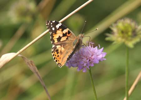
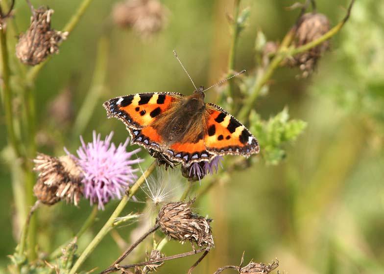
7 Brimstone (m), Salisbury Plain Brown Argus, Salisbury Plain Common Blue (f), Salisbury Plain Painted Lady, Salisbury Plain Small Tortoiseshell, Salisbury Plain
8 LOCATION Explorer Map 184: Salisbury & The Plain Landranger (pink) Map 131: Romsey, Andover & Test Valley Map 130: Salisbury & Stonehenge Grid references: East car park (by Shipton Bellinger Village Hall) SU West car park (beside the Tidworth to Bulford Camp road, for Salisbury Plain and Shipton Bellinger) SU Brown Hairstreak master tree SU Salisbury Plain viewpoint SU Shipton Bellinger is on the eastern edge of Salisbury Plain. It is about a mile north of the A303 Andover to Wincanton road, north-east of Salisbury and about 7 mile east of Stonehenge. For the Brown Hairstreak site close to Shipton Bellinger village, you can either park close to the Village Hall at SU and walk west, or park off the minor road from South Tidworth to Bulford Camp at SU and walk east. Starting from the Village Hall, after about 150 m the path divides and two parallel paths go west. Take the path on the south side because you will have a tangled, sunlit hedge of blackthorn scrub and brambles on your right and will find that there are several high ash trees close to this hedgerow. The tree identified by Matthew Oates is at SU220457, which is after the two parallel paths rejoin. As you walk further on, Salisbury Plain will be straight ahead. Pewsey Down NNR is just to the north of Salisbury Plain on the southern edge of Marlborough Downs. It is on the minor road from East Everleigh (on the A342) to Pewsey (on the A345). From Shipton Bellinger follow the A338 north to the cross-roads with the A342. Turn left towards Devizes and look for the second right turn to Pewsey There is no organized disabled access, but I think it would be possible to reach the Brown Hairstreak avenue with a wheelchair. Park near the village hall, and follow the path westwards. It may become impassable as you go further, but not until there is viewing of the flight territory. Alternatively footpath entrances on the west side, to both Shipton Bellinger and onto Salisbury Plain, may allow some wheelchairs or mobility scooters to be used comfortably. Facilities and refreshments should be available at the Boot Inn in Shipton Bellinger.
PRESTBURY HILL Gloucestershire
 PRESTBURY HILL Gloucestershire for www.discoverbutterflies.com the website for the book Discover Butterflies in Britain D E Newland 2009 Cheltenham Racecourse from Butterfly Conservation s Prestbury Hill
View from the summit of Gun Hill, looking north-east
 GUN HILL Norfolk from www.discoverbutterflies.com the website for the book Discover Butterflies in Britain D E Newland View from the summit of Gun Hill, looking north-east Gun Hill is a high sand dune
Lincolnshire Walks. Ancaster. Three cir cular walks of2 3/4,4or 6km (11/3, 21/2 or 33/4 miles)
") Lincolnshire Walks Ancaster Three cir cular walks of2 3/4,4or 6km (11/3, 21/2 or 33/4 miles) Introduction These walks are set in the attractive countryside around the historic town of Ancaster. The town
Lincolnshire Walks Ancaster Three cir cular walks of2 3/4,4or 6km (11/3, 21/2 or 33/4 miles) Introduction These walks are set in the attractive countryside around the historic town of Ancaster. The town
Fertile farms in the heart of Kent
 55 55 Fertile farms in the heart of Kent A bright sunny day is perfect for enjoying the rich and fertile Kent countryside and outstanding views across the valley of the Great Stour to the North Downs.
BUTTERFLY REPORT FOR 2010 (Medina Valley Centre) Rachel Luxton
 Rachel Luxton") BUTTERFLY REPORT FOR 2010 (Medina Valley Centre) Rachel Luxton The butterfly index for 2010 is given in figure 1, together with the previous years records for comparison. The transect was walked 25 out
BUTTERFLY REPORT FOR 2010 (Medina Valley Centre) Rachel Luxton The butterfly index for 2010 is given in figure 1, together with the previous years records for comparison. The transect was walked 25 out
Ravensgate Hill. Results of Butterfly Monitoring. Tricia Atkinson Glos Branch of Butterfly Conservation March Gloucestershire Branch Page 1
 Ravensgate Hill Results of Butterfly Monitoring 213 Gloucestershire Branch Page 1 Tricia Atkinson Glos Branch of Butterfly Conservation March 214 Results of 213 butterfly monitoring on Ravensgate Hill
Sandilands to Huttoft Bank
 Coastal Country Park Walks Sandilands to Huttoft Bank A CIRCULAR WALK OF 11KM (7 MILES) INTRODUCTION The Lincolnshire Coastal Country Park lies between Sandilands, Chapel St Leonards and Huttoft on the
Chapel Point to Anderby Creek
 Coastal Country Park Walks Chapel Point to Anderby Creek A CIRCULAR WALK OF 8.5 OR 6 KM (5.3 OR 3.75 MILES) INTRODUCTION The Lincolnshire Coastal Country Park lies between Sandilands, Chapel St Leonards
Lincolnshire Limewoods Walks. Woodhall Spa. A circular walk of 13km (8 miles)
") Lincolnshire Limewoods Walks Woodhall Spa A circular walk of 13km (8 miles) Introduction The Lincolnshire Limewoods is an area between Wragby, Bardney and Woodhall Spa. It is a fantastic place to explore
Lincolnshire Limewoods Walks Woodhall Spa A circular walk of 13km (8 miles) Introduction The Lincolnshire Limewoods is an area between Wragby, Bardney and Woodhall Spa. It is a fantastic place to explore
Lincolnshire Walks. Grainthorpe. Three circular walks of 2 ¾, 9 and 9 ½ km (1 ¾, 5 ½ and 6 miles)
") Lincolnshire Walks Grainthorpe Three circular walks of ¾, 9 and 9 ½ km (1 ¾, ½ and 6 miles) Introduction Explore the coastal marshes, arable hinterland, Louth Navigation canal and the village of Grainthorpe
Lincolnshire Walks Grainthorpe Three circular walks of ¾, 9 and 9 ½ km (1 ¾, ½ and 6 miles) Introduction Explore the coastal marshes, arable hinterland, Louth Navigation canal and the village of Grainthorpe
Countryside Walks. 1) Highclere Park Public Walk.
 Highclere Park Public Walk.") 1) Highclere Park Public Walk. Access: From Highclere Estate Main Entrance at Whitway, please note there is no parking on site or access for vehicles. Open: Throughout the year. Description: This footpath
1) Highclere Park Public Walk. Access: From Highclere Estate Main Entrance at Whitway, please note there is no parking on site or access for vehicles. Open: Throughout the year. Description: This footpath
Murlough. Dunes open access, some restricted areas Woodland open access, some restricted areas
 A2 Belfast Road Dundrum Murlough P3 N Dundrum Bay boathouse Ballykinler MOD Firing Range P4 P5 Downshire Bridge inlet floods at high tide Murlough Farm Private PNT Murlough House Private Seals agricultural
The Hundred Parishes
 The Hundred Parishes Walks from railway stations number 9 6.4 miles (10kms) from Bishop s Stortford to Stansted Mountfitchet Start: Bishop s Stortford station (Grid Reference TL492209) (ample parking and
Cilgerran Wildlife Park Circular Walk
 Walking embrokeshire Cilgerran Wildlife ark Circular Walk It s good to walk, so why not step out and sample some of the walks your neighbourhood has to offer. This pleasant and interesting walk which starts
Slindon Folly - South Downs, West Sussex
 Slindon Folly - South Downs, West Sussex Starts at Park road-side near entrance to Slindon College 2 hours 15 minutes 4.5miles 7.2km Easy ID: 0.1598 Developed by: Chris Mumford Checked by: Rockpit www.ramblersroutes.org
9.5 km Circular 3 hours
 RANMORE CIRCULAR A 6 mile (9.5km) circular walk from Boxhill and Westhumble Station in the village of Westhumble, passing through part of the Polesden Lacey Estate, Ranmore Common and Denbies Vineyard.
Heartwood Forest, in Sandridge, Hertfordshire, is a place where everyone can find space, peace, wildlife and miles of beautiful woodland to explore.
 Heartwood Forest Accessibility Statement September 2016 Purpose: This accessibility statement outlines the available facilities and access information for Heartwood Forest. Welcome We, the Woodland Trust,
10 Miles Circular 5 hours
 VISIT RYEDALE PICKERING AND CAWTHORN CAMPS 10 Miles Circular 5 hours Moderate Terrain 120616 A 10 mile (16km) there and back walk from the market town of Pickering in Ryedale. The route heads north through
Cleeve Common Self-Guided Walk 1 Family Circular
 Cleeve Common Self-Guided Walk 1 Family Circular Start point: Quarry Car Park Nearest postcode: GL52 3PW please note this is for the golf club. To find the quarry car park drive past the golf club car
Bakewell Club Site - Robin Hood's Stride
 Bakewell Club Site - Robin Hood's Stride Camping and Caravanning Route Summary A circular walk with fabulous views winding it's way through the beautiful White Peak scenery. Points of interest include
BUTTERFLY CONSERVATION DORSET BRANCH
 N No.84 Spring 2017 BUTTERFLY CONSERVATION DORSET BRANCH Butterfly Conservation is an organisation dedicated to saving wild butterflies and moths and their habitats. Dorset has a very active branch of
Hammer Vale and Linchmere Common
 point your feet on a new path Hammer Vale and Linchmere Common Distance: 9 km=5½ miles or 6 km=3¾ miles easy walking with one steep section Region: Hampshire, West Sussex Author: Botafuego Refreshments:
Maps The maps provided are a guide and are not to scale. Please use OS Explorer Map 120 (Chichester).
.") A Walker s Guide - Chichester Harbour Useful Information Directions All the walks were tested in 2013. Please note, however, that some footpaths may be diverted and buildings such as pubs may have changed
A Walker s Guide - Chichester Harbour Useful Information Directions All the walks were tested in 2013. Please note, however, that some footpaths may be diverted and buildings such as pubs may have changed
Thornton le Dale Walks
 Thornton le Dale Walks A collection of circular walks in, and around, the village www.visitthorntonledale.co.uk Thornton-le-Dale Traders Forum and Thornton le Dale Parish Council 1 Thornton le Dale Circular
Example Outdoor Education Risk Assessment
 1. General information Type of activity: Location: Date(s): Time(s): Adult to student ratio: Nearest Hospital A&E (including tel. number): For rural settings Site grid reference: OS map sheets: Mobile
For more information and to buy this book click here ISBN: CICERONE. Guides for walkers, trekkers, mountaineers, climbers and cyclists
 For more information and to buy this book click here ISBN: 9781852845377 CICERONE Guides for walkers, trekkers, mountaineers, climbers and cyclists www.cicerone.co.uk WALK 5 Ouston and Urpeth Distance
F R E E R E s E R v o i R WA L K s REsERvoiR WALKs To BLoW AWAY THE CoBWEBs BRougHT To You BY
 F R E E r e s e r v o i r WALKS reservoir WALKS TO BLOW AWAY THE COBWEBS Brought to you by Only available in Yorkshire. We look after 72,000 acres of land in Yorkshire, spanning the North York Moors, the
The Alice Lisle Walking Guide
 The Alice Lisle Walking Guide Using some local knowledge we have been able to design some great walks starting and finishing at the Alice Lisle. If you re planning a group walk, please get in contact with
Footpaths and walks in the Leckhampton Fields
 APPENDIX 5 Footpaths and walks in the Leckhampton Fields Because of its network of footpaths, the Leckhampton Fields have many different walks. The rich diversity of landscape, hedgerows, trees, streams,
Walks Around Bishopstone & Hinton Parva
 The Walks: From ½ mile ambles to 8 mile scenic loops Hinton Parva Walks H1 H2 H3 Bishopstone Walks B1 B2 B3 B4 B5 Walk B1: Bishopstone Village, The Dingle (stream) & Pond A short circular village amble
A circular walk of or km (2 1 4 or miles)
") Grantham A circular walk of 3 3 4 or 5 3 4 km (2 1 4 or 3 1 2 miles) Introduction This relatively short circular walk, which starts in the middle of Grantham, offers plenty of variety. The route takes
Grantham A circular walk of 3 3 4 or 5 3 4 km (2 1 4 or 3 1 2 miles) Introduction This relatively short circular walk, which starts in the middle of Grantham, offers plenty of variety. The route takes
Pegsdon Hills and The Icknield Way
 Pegsdon Hills and The Icknield Way A country walk generally on the level but with some steep slopes with wide, open views along the ancient Icknield Way Essential Facts Route distance: Approximate time:
There are toilets at Manningtree Station, Flatford (close to the hump back bridge) and in Dedham.
 and in Dedham.") Arriving by Train Main Features of the Walk Outline Route Employs particularly attractive paths, many of which offer impressive views across Dedham Vale. Includes a section along the tidal section of the
Arriving by Train Main Features of the Walk Outline Route Employs particularly attractive paths, many of which offer impressive views across Dedham Vale. Includes a section along the tidal section of the
Skyline Day Race Information Sunday 13th Jan, from 10:00am University of Bath, Bath, BA2 7JY.
 Skyline Day Race Information Sunday 13th Jan, from 10:00am University of Bath, Bath, BA2 7JY. On the Day Registrations Assuming we have not sold out, on the day prices will be follows. 500m - 5 (Even if
BALCOMBE AND ARDINGLY RESERVOIR, WEST SUSSEX
 BALCOMBE AND ARDINGLY RESERVOIR, WEST SUSSEX 7 miles Circular 4 hours 080816 Challenging Terrain Hi, I'm Luke and this is my West Sussex Weekends walk It's a 7 mile loop from Balcombe rail station, taking
Skyline 10km Series Race Information Saturday 12th Jan, 18:00 University of Bath, Bath, BA2 7JY.
 Skyline 10km Series Race Information Saturday 12th Jan, 18:00 University of Bath, Bath, BA2 7JY. On the Day Registrations Assuming we have not sold out, on the night prices will be follows. 5km - 17 all
Thornton le Dale Walks
 Thornton le Dale Walks A collection of walks in and around the village Thornton le Dale Traders Forum www.visitthorntonledale.co.uk Thornton le Dale Walks Walk 1: Beck Isle Cottage and All Saints Church
Groton Open Space Association s AVERY FARM EXPLORER GUIDEBOOK
 Groton Open Space Association s AVERY FARM EXPLORER GUIDEBOOK AVERY FARM DESCRIPTION: Called one of the most biologically diverse and valuable conservation sites in eastern Connecticut, this beautiful,
Bonnie Prince Charlie Walk
 Bonnie Prince Charlie Walk A waymarked route from Ashbourne to Derby to celebrate the 60th anniversary (1995) of the formation of the Ramblers' Association. This route follows the general direction of
DESIGN CODE. Enterprise West Harlow London Road North Design Code 21
 DESIGN CODE Enterprise West Essex @ Harlow London Road North Design Code 21 4 MAXIMUM BUILDING HEIGHTS 4.1 Table 4A sets out maximum building height standards for each character area within the LDO boundary.
Welsh Newton and Woodland
 Welsh Newton and Woodland This is a 8.2km miles (approx) walk which will take about 2.5 hours at a relaxed and leisurely pace. There are a few hills but no steep inclines. Start at Llangrove bus stop and
Dyrham and Hinton Parish Walks
 Dyrham and Hinton Parish Walks A series of five walks in the parish, exploring most of the public footpaths. By John Miller Each walk is described in detail, with a complete map, to provide a handy guide
LDWA SOUTH DOWNS MARATHON
 AHD ahead SDW South Downs Way BL/BR bear left/bear right TL/TR turn left/turn right SP signpost/fingerpost X cross LEG 1 - EAST DEAN to WP1 NORTON GR 470019. Open 1030 to 1300. 9.6 miles. 1.1 From village
Uif!Sfe!Mjpn-!Mpnhepn! bne!dbnnpdl!dibtf-! Tubggpsetijsf
 Uif!Sfe!Mjpn-!Mpnhepn! bne!dbnnpdl!dibtf-! Tubggpsetijsf 7/6!njmft! Djsdvmbs!!!!!!! 4!up!4/6! ipvst Strenuous Terrain Uif!Sfe!Mjpn!jt!b!dmbttjd!wjmmbhf!qvc-!b! hsfbu!qmbdf!up!tbujtgz!zpvs!ivnhfs!bgufs!b!
Walk 2: Beamsley Beacon and Bolton Abbey
 Walk 2: Beamsley Beacon and Bolton Abbey Start and Finish: The Memorial Hall, Main Street, Addingham, LS29 0LZ, SE 079 497 The shortest walk is about 5½ miles (8.8km) The medium Walk is about 8¼ miles
National Status: Scarce, Native
 Carex humilis Leyss. National Status: Scarce, Native Dwarf Sedge 1879-2015 6 5 4 3 2 1 SU SZ 1 2 4 5 6 7 8 S Hants: Infrequent Native Confined to the chalklands in the far west between Vernditch and Breamore,
Butterfly and Moth Events in Dorset
 Butterfly Conservation Dorset Branch Butterfly and Moth Events in Dorset No. 87 April to Sep 2018 1 BUTTERFLY CONSERVATION DORSET BRANCH Butterfly Conservation is an organisation dedicated to saving wild
Tideswell to Castleton
 Tideswell to Castleton 1 Walk summary Length: 14 km, 8.5 miles Maps: OS Explorer OL1 The Peak District - Dark Peak Area, OS Explorer OL24 The Peak District - White Peak Area, OS Landranger 110 Sheffield
CASTLETON and HOPE. Medieval Historical Landscape a self-guided trail
 CASTLETON and HOPE Medieval Historical Landscape a self-guided trail Explore Castleton and Hope s medieval and later past with this self-guided trail. You will discover the history behind the landscape
Visual impact assessment viewpoint analysis
 Visual impact assessment viewpoint analysis 1 Introduction In this section we analyse the most important viewpoints affected by this development. In each viewpoint where it is relevant we have cross referred
THE WELLDIGGERS ARMS, HESWORTH AND FITTLEWORTH TRAIL
 THE WELLDIGGERS ARMS, HESWORTH AND FITTLEWORTH TRAIL 5.5 miles Circular 3 hours 041017 Challenging Terrain A 300-year-old pub turned country-inn on the edge of the South Downs National Park, The Welldiggers
8 Manor Common and Menacrin Downs. 8.1 Situation
 8 Manor Common and Menacrin Downs 8.1 Situation Blisland Manor Common is situated five and a half miles north-east of Bodmin, beside the north side of the A.30 highway leading from Bodmin to Launceston.
Beautiful Walks from the Blue Ball Inn
 Walk No. 7 COAST AND VALLEY WALK Countisbury, Glenthorne, County Gate, Brendon, Rockford and Wilsham 10 MILES APPROX. Walking time 5 hours approx. (not including breaks)> OS Sheet 64/74 Lynton and Lynmouth.
Twin Canyons Ranch 3,019+/- Acres Throckmorton County, Texas $4,211,505 ($1,395/acre)
") Office: (214) 361-9191 Twin Canyons Ranch 3,019+/- Acres Throckmorton County, Texas $4,211,505 ($1,395/acre) GENERAL DESCRIPTION: The 3019+/- acre Twin Canyons Ranch is one of the most scenic and majestic
Office: (214) 361-9191 Twin Canyons Ranch 3,019+/- Acres Throckmorton County, Texas $4,211,505 ($1,395/acre) GENERAL DESCRIPTION: The 3019+/- acre Twin Canyons Ranch is one of the most scenic and majestic
Launton to Bicester nature footpath improved
 Launton to Bicester nature footpath improved Published 13 July 2012 An attractive rural footpath linking Launton to Bicester has brought back into use by the council's Countryside team. Staff have improved
Waterhead Pier to Orrest Head, Windermere and Bowness
 Waterhead Pier to Orrest Head, Windermere and Bowness A 4 1 2 hour walk through Woodlands and the Troutbeck Valley with spectacular Lake and Mountain views and a lakeshore path. Walk 10 Walk 11 Walk 12
This walk description is from happyhiker.co.uk
 This walk description is from happyhiker.co.uk Pendle Hill Walk From Barley Starting point and OS Grid reference Ordnance Survey map Distance Traffic light rating Barley village honesty box car park OS
Walk NOC 03 Location: Llyn y Fan (the lake) and Fan Brycheinog (the mountain) off Trecastle Road
 and Fan Brycheinog (the mountain) off Trecastle Road") 8 Walk NOC 03 Location: Llyn y Fan (the lake) and Fan Brycheinog (the mountain) off Trecastle Road Directions: Distance (miles): Time (hours): Length of Walk: Turn right out of the castle, take first left
8 Walk NOC 03 Location: Llyn y Fan (the lake) and Fan Brycheinog (the mountain) off Trecastle Road Directions: Distance (miles): Time (hours): Length of Walk: Turn right out of the castle, take first left
Owned by: Wessex HGPGC Ltd Wind Direction W - NNW (275 to 340 ) Best: NW (305 )
 Best: NW (305 )") Site Code 2.028 OS Grid Ref: ST 797 086 (Map 194) GPS: N50:52.549 W2:17.312 Owned by: Wessex HGPGC Ltd Wind Direction W - NNW (275 to 340 ) Best: NW (305 ) Farmed by: Mr Owen Yeatman Lowbrook Farm Belchalwell
Site Code 2.028 OS Grid Ref: ST 797 086 (Map 194) GPS: N50:52.549 W2:17.312 Owned by: Wessex HGPGC Ltd Wind Direction W - NNW (275 to 340 ) Best: NW (305 ) Farmed by: Mr Owen Yeatman Lowbrook Farm Belchalwell
Walk: NOC 08 Location: Cym Glyn near Brecon
 33 Walk: NOC 08 Location: Cym Glyn near Brecon Directions: Not easy to find at all. Go to Libanus, then head towards Brecon on the A470. Take minor C road single track lane first right as you come out
Other useful information Nearest Refreshments: In the Victoria Inn or the Lugger Inn, in Chickerell OS Explorer Map: OL15 (Purbeck and South Dorset)
") they find the diamond, and then to Holland, where they try to sell it, finding themselves in worse trouble than ever as a result. It is ten years before John returns to Moonfleet, fortuitously being shipwrecked
they find the diamond, and then to Holland, where they try to sell it, finding themselves in worse trouble than ever as a result. It is ten years before John returns to Moonfleet, fortuitously being shipwrecked
Although the majority of these walks are around country lanes you should still follow the Country Code:-
 With the update of the Parish Plan was a request for details of any Walks around Pillaton The following pages give several walks that I and my wife have done for many years. Please be aware that NONE OF
Walk Description. Directions
 Title: East Hanningfield Distance: 8 miles / 9 miles Time taken: 3-3½ hours Location: 5 miles south east of Chelmsford Parking: Free car park off The Tye, East Hanningfield, next to the primary school
HERITAGE, LEGEND and NATURE in the VALLEYS WALK ND6 SARN HELEN, ST PATRICK & HENRHYD FALLS The Romans, Saint Patrick and a Waterfall
 HERITAGE, LEGEND and NATURE in the VALLEYS WALK ND6 SARN HELEN, ST PATRICK & HENRHYD FALLS The Romans, Saint Patrick and a Waterfall Historic & Geographic Background Banwen is best known as a former mining
NEWLANDS CORNER AND ST MARTHAS
 NEWLANDS CORNER AND ST MARTHAS 10k CIRCULAR ROUTE 2½-3HRS GU4 8SE From Newlands Corner on the North Downs just outside Guildford, you can enjoy one of the most beautiful panoramas of quintessential English
Husthwaite to Byland Abbey
 Husthwaite to Byland Abbey This walk begins with a loop round the village of Husthwaite and continues towards Coxwold along a disused railway line, which is now a right of way. It passes through Coxwold
Tinneyhall Wood, Cornwall - About 9 ½ acres, 59,000
 Tinneyhall Wood, Cornwall - About 9 ½ acres, 59,000 Tinney Hall is a hamlet close by the small hilltop village of Lewannick, which is centred around a crossroads. This is unusual for Cornwall, where the
Monday, December 3, 12
 Endangered species are like fire alarms. They tell us about problems in our home we call Earth. If we listen to their alarm calls, they could help us improve our lives and the health of our planet. Definitions
Lacock Road Races - 10th June 2018, from 09:00 Lacock Playing Fields, Lacock, SN15 2LG.
 Lacock Road Races - 10th June 2018, from 09:00 Lacock Playing Fields, Lacock, SN15 2LG. Important Notices This is a Closed Roads event. As always, an event never occurs in isolation, and we must work with
TOWPATH WALK. Fold out map. inside! Revealing Oldknow s Legacy GUIDE & MAP MARPLE & MELLOR. oldknows.com
 2 TOWPATH WALK Fold out map inside! 3 4 Revealing Oldknow s Legacy GUIDE & MAP & MELLOR oldknows.com and the Peak Forest Canal in Marple SAMUEL OLDKNOW Samuel Oldknow, a Lancashire born muslin manufacturer,
What are National Parks?
 Honeypot sites What are National Parks? National Parks are protected areas of natural beauty. The areas include mountains, moorland, heathland, woodland and coasts. National Parks are not theme parks they
Sunday, June 14 th 9:30am Pine Cone Bird Feeders Meet Courtney at the Rec. Hall to learn how to make your own bird feeder out of pine cones.
 Fall Creek Falls Activities June 14 th 21 st Welcome to Fall Creek Falls State Park! Summer vacation time is here and what a great place to spend it! The park provides a wonderful opportunity to enjoy
LDWA SOUTH DOWNS MARATHON 13 th MAY 2018
 AHD ahead SDW South Downs Way BL/BR bear left/bear right TL/TR turn left/turn right X cross LEG 1 - EAST DEAN to WP1 NORTON GR 470019. Open 1030 to 1300. 9.7 miles. 1.1 From village hall TL and walk to
discovered main bill energy
 teacher mind discovered record shall suddenly legs main can't west written felt wide job exercise flowers bill winter divided believe site energy arms interest energy flowers simple cells finished weather
GIVE WILDLIFE a CHANCE Poster Contest
 28 th Annual GIVE WILDLIFE a CHANCE Poster Contest Open to Georgia students in K- 5th Grade The Georgia Department of Natural Resources (DNR), and The Environmental Resources Network, Inc. (TERN) encourage
Mississippi River Life
 Mississippi River Life National Mississippi River Museum and Aquarium Conservation Education Curriculum Target Grades: Pre K 4 th grade Key Words: Habitat, diversity Subject Areas: science, biology Duration:
Water vole presentations notes
 Water vole presentations notes Slide One Hello everyone, my name is and I work for the Norfolk Wildlife Trust. The Norfolk Wildlife Trust is a conservation charity. Our job is to care for and to protect
Greenwood. Walks. Cossall Canal Walk. Cossall Canal Walk
 Cossall Canal Walk C5 Cossall Canal Walk C5 Features: Cossall is a picturesque, relatively unspoiled village on the Nottingham canal, four miles south-east of Eastwood. Architecturally interesting. See
Skyline 10km Series Race Information 15th November, 6th December, 17th January, 14th February 11:00am Start University of Bath, Bath, BA2 7JY.
 Skyline 10km Series Race Information 15th November, 6th December, 17th January, 14th February 11:00am Start University of Bath, Bath, BA2 7JY. Important Notices New Location We are now in West Car Park!
TWO FORKS RANCH A5 REAL ESTATE. 790 Acres. Smiths Fork - Lincoln County - Wyoming
 TWO FORKS RANCH 790 Acres Smiths Fork - Lincoln County - Wyoming A5 REAL ESTATE WWW.A5REALESTATE.COM QUICK FACTS Located in the upper Smiths Fork drainage of Lincoln County, Wyoming, the Two Forks Ranch
Redesdale Arms. A Trio of Walks
 Redesdale Arms A Trio of Walks Welcome to The Redesdale Arms Hotel The award winning 34 bedroom Redesdale Arms Hotel sits at the gateway to the Cotswolds in the High Street of the historic town of Moreton-in-Marsh.
Fig. 3.1 shows the distribution of roe deer in the UK in 1972 and It also shows the location of the sites that were studied in 2007.
 1 Roe deer, Capreolus capreolus, is the most common species of native deer in the UK. Fig. 3.1 shows the distribution of roe deer in the UK in 1972 and 2007. It also shows the location of the sites that
2011 Peabody Museum of Natural History, Yale University. All rights reserved.
 2011 Peabody Museum of Natural History, Yale University. All rights reserved. Operation Vector Find Rangers with the New Haven Parks Department have just discovered an old map. The map shows a remote
Circle W Ranch SPRAY, OREGON. Hunting Ranching Fly Fishing Conservation
 Circle W Ranch SPRAY, OREGON Hunting Ranching Fly Fishing Conservation Circle W Ranch SPRAY, OREGON CIntroduction The Circle W Ranch is located in North Central Oregon. The North border of the ranch runs
INFORMATION SHEET NO: A7. The case for cattle-grids on commons
 25a Bell Street, Henley-on-Thames, Oxon RG9 2BA tel: 01491 573535 fax: 01491 573051 website: www.oss.org.uk (charity no: 1144840, (registered in England and Wales, limited company number 7846516) INFORMATION
THE DOG AND DUCK HAREWOODS ESTATE TRAIL. 6 Miles Circular 3 hours. Getting there. Walk Sections
 THE DOG AND DUCK HAREWOODS ESTATE TRAIL Moderate Terrain A 6 mile circular pub walk from the Dog and Duck in Outwood, Surrey. The Dog and Duck is a delightful pub where everyone is made welcome. From walkers
Heartwood Forest Small Mammal Survey Report October 2012
 Small Mammals at Heartwood In early we were lucky to be visited by Veronica Carnell from Northumbria Mammal Group (pictured left). She kindly led a small group of volunteers in small mammal trapping as
holly tree Wellhill Farm Woodyard Bramham House red kites Round House ha-ha
 This 6.4 mile walk around the magnificent Bramham Park Estate has been made possible with the active support of the owner of the Estate, Nick Lane Fox, with funding from Natural England, as part of Defra
B Buckmoth. Look quickly or you ll miss the buckmoth! These bold black and white moths fly quickly and for only a few weeks in the fall.
 A Z A Amphibians The Pine Bush is home to many different amphibians. This is the eastern spadefoot toad. Spadefoot toads have back feet shaped liked shovels used for digging backward into soft sand. If
EchoLocation Location Bats in Churches Survey
 EchoLocation Location Bats in Churches Survey Why survey a church? These fascinating ancient buildings often provide plenty of nooks and crannies for bats to utilise at different times of the year and
Lacock Road Races - 18th June 2017, from 09:00 Lacock Playing Fields, Lacock, SN15 2LG.
 Lacock Road Races - 18th June 2017, from 09:00 Lacock Playing Fields, Lacock, SN15 2LG. Important Notices This is a Closed Roads event. As always, an event never occurs in isolation, and we must work with
Parish Council s Comments Planning Reference Land at Ledbury Road, Wellington Heath November 2018
 2018 Planning Reference 184105 - Land at Ledbury Road, Wellington Heath 183936 - Treetops, Horse Road, Wellington Heath 183920 - The Beck, The Common, Wellington Heath 183143/F - Variation to Permission
Walk Description. Directions
 Title: Saffron Trail: Battlesbridge to Chelmsford Distance: 14¾ miles Time taken: 6 hours Start Point: Outside the Barge Inn, Battlesbridge OS Explorer Map: 175 & 183 Grid Ref.: TQ 780 947 Transport: Rail:-
Great Barford and The River Great Ouse
 Great Barford and The River Great Ouse A riverside route which follows the River Great Ouse, with historic sites at Barford Bridge, Danish Camp and Willington Dovecote Essential Facts Route distance: Approximate
Zoo Activity Packet Grades 3-5. Thank you for choosing Reid Park Zoo for a field trip this year!
 Zoo Activity Packet Grades 3-5 Thank you for choosing Reid Park Zoo for a field trip this year! Chaperone Tips Thank you for volunteering to chaperone your child s class trip to the Reid Park Zoo. Below
Reduction in Biological Diversity Section 4.1 p Section 4.3 p
 Reduction in Biological Diversity Section 4.1 p. 57-65 Section 4.3 p. 72-78 Review Ecological Diversity A variety of ecosystems (mountains, forests, deserts) and how they interact together. Community Diversity
The Timsbury Fishery - Rods. River Test, Hampshire
 The Timsbury Fishery - Rods River Test, Hampshire The Timsbury Fishery Rods on a famous stretch of the River Test in Hampshire Stockbridge 6 miles, Winchester 10 miles, London 70 miles The River Test The
the Carta Valley Ranch
 the Carta Valley Ranch Ranching... Hunting... Nature... Evoking romantic days of the Old West, this South Texas Ranch is a magnificent Texas Hill Country retreat perfect for the seasoned hunter, rancher,
9.5 km Circular 3 hours
 MEDIEVAL WAVERLEY Challenging Terrain A 6 mile (9.5km) undulating circular walk from Tilford village passing close to The Sands village and the historic ruins of Waverley Abbey. From the top of Crooksbury
The Indian Myna Bird: Major Pest. Yelarbon State School
 The Indian Myna Bird: Major Pest Yelarbon State School Enviro-Stories is an innovative literacy education program that inspires learning about natural resource and catchment management issues. Developed