2017 DEERFIELD RIVER WATERSHED TROUT SPAWNING SURVEYS
|
|
|
- Lee Waters
- 5 years ago
- Views:
Transcription


1 2017 DEERFIELD RIVER WATERSHED TROUT SPAWNING SURVEYS FINAL REPORT Prepared for Deerfield River Watershed Chapter of Trout Unlimited By Michael B. Cole Cole Ecological, Inc. May 2018
2 TABLE OF CONTENTS LIST OF FIGURES... ii ACKNOWLEDGMENTS... iii EXECUTIVE SUMMARY... iv BACKGROUND & INTRODUCTION... 1 SPAWNING SURVEY METHODS... 2 FIELD TRAINING... 2 SURVEY TIMING... 3 FIELD SURVEY METHODS... 3 IDENTIFYING REDDS... 3 Complete Redds... 3 Test redds... 4 Superimposition & chaining... 5 DATA COLLECTION... 5 DETERMINING EGG PRESENCE... 6 LATE WINTER REDD RE-SURVEYS... 7 DATA MANAGEMENT AND ANALYSIS... 7 DNA ANALYSIS OF FALL-SAMPLED EGGS... 8 RESULTS... 9 SURVEY EFFORT & TIMING... 9 REDD COUNTS AMBIENT ENVIRONMENTAL CONDITIONS Water Depths at minimum flow Dominant substrate DEWATERING OF REDDS DNA ANALYSIS OF TROUT EGGS LATE WINTER EGG SURVEYS DISCUSSION i
3 LIST OF FIGURES Figure 1. A complete pit and tailspill redd: this one from the Deerfield River in October, Note oblong shape Figure 2. A test (or incomplete) redd. Note lack of tailspill and roundish overall shape. This redd was photographed in the Deerfield River in October Figure 3. This figure shows the location of eggs within a redd. Image from the Washington Department of Fish & Wildlife website Figure 4. Deerfield River discharge at USGS gage station , October 28 through December 9, 2017 (unpublished data) Figure 5. Number of trout redds with eggs and without eggs identified in the Deerfield River and select tributaries in fall Figure 6. Occurrence of trout redds with and without eggs at three depth intervals in the Deerfield River, fall Figure 7. Redd pit water depths (@ low flows) in trout redds with eggs and without eggs in four Deerfield River spawning surveys reaches, fall Error bars = standard deviation of the mean water depth Figure 8. Particle size of dominant substrate occurring in redd locations in four Deerfield River spawning survey reaches in fall Figure 9. Deerfield River Spawning Survey Reach 1: Fife Brook Dam to Carbus Bend (0.9 mi.). Yellow circle indicates area of concentrated spawning activity in fall Figure 10. Deerfield River Spawning Survey Reach 2: Shady Pool to Bridge to Nowhere (0.9 mi.); and reach 2A (Beaver Island and Channel US of Zoar Gap). Yellow circles indicate areas of concentrated spawning activity in fall Figure 11. Deerfield River Spawning Survey Reach 3: Zoar Gap to island at Cold River confluence (2.1 mi.) Figure 12. General water levels at 125 cfs in locations of concentrated redds in the Deerfield River in fall Upper photo: Reach 1 below Fife Brook Dam; Middle photo: Reach 2 above the Bridge to Nowhere; Lower photo: Reach 2 in the back end of Shady Pool Figure 13. Examples of dewatering of redd tailspills in the Deerfield River in fall Figure 14. Photographs of eyed eggs and yolk sac fry collected from Deerfield River brown trout redds surveyed in March, ii
4 ACKNOWLEDGMENTS This study was made possible through the enthusiastic commitments and generous time given by many volunteers. In alphabetical order, I d like to thank Jay Aylward, Per Brandin, Sean Bresnehan, Joseph Drake, Bob Gancarz, Jean Gobillot, John Gutowski, Eric Halloran, Jason Hooper, Chris Jackson, John "Jack" Kovach of the Yankee Fisherman Show, Christopher Lenaerts, Bill Obear, Sean O'Brien, Kevin Parsons, Randy Prostak, Henry Sweren, Horace Taft, and Michael Vito. The study design and survey protocols were developed with assistance from Melissa Grader of the USFWS, Don Pugh (retired U Mass), and Caleb Slater of MassWildlife. Thanks also to Adam Kautza of MassWildlife for his support for the project and for accompanying crews in the field. This work was made possible through generous donations from the MA/RI Council of Trout Unlimited, the Pioneer Valley Chapter of Trout Unlimited, the Greater Boston Chapter of Trout Unlimited, the Northeast Massachusetts Chapter of Trout Unlimited, the Connecticut River Conservancy, Mark Burton, Paul Beaulieu, and other individuals. A big thank you to Thomas & Thomas Fly Rods for their generous financing of the trout egg DNA analysis. Trout eggs were analyzed at the National Genomics Center for Wildlife and Fish Conservation in Missoula, Montana. To the many volunteers who gave their time to this project, THANK YOU. iii
5 EXECUTIVE SUMMARY In fall 2017 and late winter 2018, the Deerfield River Watershed Chapter of Trout Unlimited (DRWTU) performed a trout spawning survey of the Deerfield River and select tributaries in order to begin to understand the extent to which trout successfully spawn in the Deerfield River. The objectives of the study were to document trout spawning activity in the river below Fife Brook Dam; to determine the extent to which spawning redds are subject to de-watering (stranding) resulting from hydropeakingrelated water level fluctuations; and to begin to quantify winter survival of trout eggs in redds and determine if survival rates are related to water depth at minimum flows. Surveys were led by Dr. Mike Cole and performed by DRWTU members from early November through early December 2017 (the fall period). Late winter surveys to assess over-winter survival of eggs were performed on March 17 and 19, All field crews were trained in the field survey protocols by Dr. Cole. Five survey reaches in the Deerfield River were selected between Fife Brook Dam and the #4 Deerfield Dam. Each reach was surveyed on foot at least twice during the fall survey period. Fall spawning surveys were also performed on the lower reaches of six Deerfield River tributary streams. During fall surveys, crews identified and marked redds, measured ambient physical conditions associated with redds, and checked each redd for the presence of eggs. Fall surveys identified 101 redds among the four reaches in the Deerfield River in the survey area upriver of Route 2. Ninety eight of these redds were fully constructed, and 37 of these redds contained eggs. Spawning activity was heaviest in the uppermost reach closest to Fife Brook Dam and lightest in the reach farthest from the dam. A number of areas of concentrated spawning activity occurred throughout the river from Zoar Gap upriver to Fife Brook Dam, a distance spanning approximately 5.2 miles. In contrast to the many redds found in the Deerfield River, no redds were encountered during fall surveys of the lower reaches of six Deerfield River tributaries. Trout redds occurred within a narrow range of substrate sizes and water depths. Redds occurred exclusively in substrates dominated by coarse gravels. Redd water iv
6 depths at low water (generally minimum flow of ~125 cfs, but with one morning of measurements made at 230 cfs) ranged from 6 to 50 cm. Water depths did not differ between redds with eggs and redds without eggs, as each was found across a similar range of depths. Redds in shallow water at low flows (6-12 cm deep) were found to have the highest percentage of eggs (52%), compared to 29% of redds in cm of water and 33% of redds in cm of water. Dewatering was frequently documented in redds occurring at depths of less than 13 cm when the river was running at a minimum flow of 125 cfs; 12 of 25 redds at depths of 6 to 12 cm were noted as being dewatered. Eight of these 12 redds contained eggs. As such, the proportion of redds with eggs that were prone to dewatering (8 of 37 or 21.6%) was nearly twice the proportion of all complete redds subjected to dewatering (12 of 98 or 12.3%). While not measured during the fall surveys, water velocities were also very low in many of these shallow-water redds at minimum flow, and sometimes only standing water occurred in redd pits. As such, trout eggs in the Deerfield River are potentially at increased risk of mortality from freezing in both dewatered and reduced water velocity conditions. Redds found to contain eggs in the fall were resurveyed in the late winter to begin to determine survivorship of eggs in the river. Late winter resurveys revealed the presence of eyed eggs and trout alevins in redds, demonstrating for the first time successful brown trout spawning in the mainstem Deerfield River below Fife Brook Dam. Based on DNA analysis of eggs collected in the fall, all 99 live eggs collected in the late winter were sampled from brown trout redds,. As the number of eggs and the ratio of live to dead eggs varied widely among redds, and the sample size of redds with eggs in late winter was small, no statistically based inferences of relationships between water depths and egg survival could be made. Few redds (3 of 27 redds resurveyed) contained numerous live eggs during the late winter surveys, and only a handful of alevins were collected, suggesting a low overall spawning-to-hatching success rate in the upper river in While questions remain regarding the effects of managed flows on egg survival in the Deerfield River, this work demonstrates that under certain conditions, brown trout v
7 eggs can survive to hatching in the river. This work also documented redds occurring in low-flow conditions that may put trout eggs at increased risk of mortality from freezing in dewatered or standing-water conditions. While at present the survival rate of trout eggs and alevins left in shallow water at minimum flows in the Deerfield River is unknown, the results of others work suggest that conditions observed and measured in this study present a real risk to the wintertime survival of eggs and alevins. Such risks could be minimized by providing flows that ensure redds remain completely inundated during the egg incubation and hatching period. vi
8 BACKGROUND & INTRODUCTION While juvenile trout of natural origin are known to be present in the Deerfield River, the source of these fish whether the mainstem Deerfield River, tributary streams, or both is presently unknown. The Deerfield River Watershed Chapter of Trout Unlimited (DRWTU) performed a trout spawning survey of the Deerfield River and select tributaries in order to begin to understand the extent to which trout successfully spawn in the Deerfield River. The objectives of this first year of surveys were: 1) document trout spawning activity in the project-affected area of the Deerfield River, 2) begin to determine the distribution and abundance of trout redds in the projectaffected area of the Deerfield River, 3) determine the extent to which current hydro project operations expose spawning redds to de-watering (stranding) or otherwise detrimental depths and velocities, 4) determine the proportion of complete and incomplete redds and determine if redd completion rates are related to water depth at low flows, and 5) quantify winter survival of trout eggs in Deerfield River redds and determine if survival rates are related to water depth at low flow. In order to achieve these objectives, spawning surveys were performed by trained DRWTU members from early November through early December Five survey reaches in the Deerfield River were selected between Fife Brook Dam and the Deerfield #4 Dam. Reaches were selected based on knowledge of concentrated spawning activities in previous years. The reaches selected for these surveys were as follows: Reach 1: Immediately below Fife Brook Dam to Carbus Bend (1.06 mi.) Reach 2: Shady Pool to Bridge to Nowhere (0.9 mi) Reach 2A: The upper end of Beaver Island and the side channel on river right upriver of Zoar Gap. Reach 3: Zoar Gap to Cold River (2.1 mi.) 1
9 Reach 4: Buckland from the confluence of Clesson Brook upriver approximately 0.5 mi. Teams of at least two people each surveyed these select river reaches. Flows and turbidity determined the precise timing of surveys. Surveys occurred exclusively on foot. During each survey, redds and fish using redds were counted within each survey reach. Each redd was identified as a complete or test (incomplete) redd according to the characteristics described later in this report. The location of all spawning activity was recorded with a hand-held GPS unit, either as individual redds (in areas of pocket spawning) or by bracketing areas of extensive spawning activity with waypoints at the upriver and downriver ends of the activity. A number of habitat variables were measured and recorded at each redd, and redd gravels were gently disturbed with a hand rake to determine the presence of eggs. In a second round of surveys to occur in early 2018, redds determined to contain eggs in the fall will be revisited in the late winter/early spring (after a sufficient number of degree days have accrued) to assess egg survival shortly prior to hatching and emergence. This interim report documents the findings of the fall 2018 surveys for distribution to agencies and other interested parties. SPAWNING SURVEY METHODS FIELD TRAINING Training was held on the first day of Deerfield River spawning surveys on November 13, Participants learned how to identify and mark redds, how to collect data associated with redds, and how to record and store waypoints with a GPS. In addition to learning the field survey protocols, survey teams were established, and the survey objectives and schedule for the remainder of the season were discussed. 2
10 SURVEY TIMING Surveys were initiated in tributaries during the first week of November and in the Deerfield River during the second week of November in Each reach in the Deerfield River was surveyed at least twice during the survey period. Surveys were performed until early December, when new redd construction was no longer observed FIELD SURVEY METHODS Upon arrival at a survey reach, survey form header information including survey reach, date, weather, flow conditions, and crew members was filled out. During initial surveys of reaches, crews walked the banks and through shallow water zones, often in a zig-zag manner across wadeable portions of the channel, to locate individual redds or areas of concentrated spawning. When sufficient time and low flows allowed, crews walked the entire survey reach. In subsequent weeks, following the identification of areas of concentrated spawning, crews often focused their survey effort on identifying and collecting data from newly constructed redds in these specific areas. IDENTIFYING REDDS Each redd encountered was first examined according to the following criteria to determine whether the redd was a complete or test redd: COMPLETE REDDS Redds are areas within river gravels that are excavated by female trout and in which eggs are laid and fertilized. The redd construction process includes the excavation of an initial pit, laying and fertilizing the eggs within the pit, and the covering the eggs by the female with loose gravels. The result of this process is a fully formed redd, complete with a classic pit and tailspill. These completed redds have also been called true redds (Dunham and Rieman, 2001). Particularly when freshly constructed, these completed redds are easy to spot and recognize. They will generally be several feet long and oblong, running parallel to the river flow, and clear of sediment. 3
 are redds that are not fully constructed.")


11 Figure 1. A complete pit and tailspill redd: this one from the Deerfield River in October, Note oblong shape. TEST REDDS Test redds (potential redds) are redds that are not fully constructed. These redds are smaller, less oblong, and lack the tailspill, the feature indicating that eggs have likely been deposited and covered. Test redds were also recorded, but were differentiated from complete redds on the survey form. Both test and complete redds were carefully checked for eggs, as described later. Classifying a redd as complete or test depended primarily on the presence of the tailspill and oblong shape. When a redd could not be neatly classified as complete or test, crews were instructed to call it a test redd. In subsequent weeks, test redds were re-examined to determine whether their status had changed with respect to their size and the presence of eggs. 4

12 Figure 2. A test (or incomplete) redd. Note lack of tailspill and roundish overall shape. This redd was photographed in the Deerfield River in October SUPERIMPOSITION & CHAINING New redds constructed over older redds is termed superimposition. Trout may use the pit of a previous redd as an egg pocket and then bury eggs leading to a chain of redds running parallel to the river s flow. Overlapping redds can create challenges to discerning individual redds within the chain. In this study, redd counts in superimposed or chained redds were based on the number of redds showing both pits and tailspills (per Barnett and Paige). DATA COLLECTION All field data were recorded on Field Data Forms provided on write-in-the-rain paper for these surveys. As redds were encountered, they were first marked with a rock-filled cloth bag at the end of the tailspill (per Barnett and Paige). The assigned redd ID number was written on the cloth bag and on an 18-inch piece of orange flagging. The bag was tied closed and the piece of flagging was tied to the bag. To minimize risk of losing the rock bags to high flows and better ensure the relocation of the redds in the early spring, the rock-fill bag was buried in the gravel at the very back of the redd so only the flagging tape was clearly visible. Redds identified as containing eggs were marked with both a piece of orange flagging and with an 8 piece of red cordage. Locations of individual redds (when isolated) or groups of redds (when in close proximity to each other) were marked with a Garmin GPS. Redd locations were also 5
 in the redd was measured from the center of the redd pit, and the total length of the redd (in cm) was measured from the")
13 flagged in the field by hanging orange flagging on woody vegetation on the bank directly across from the redd/redds. The following measurements were made at each redd: The Water depth (cm) in the redd was measured from the center of the redd pit, and the total length of the redd (in cm) was measured from the upstream edge of the redd pit to the most downstream point on the tailspill. The time at which the water depth was measured was also recorded. Substrate was characterized by an estimate of the dominant size-class of substrate in which the redd was excavated. The substrate surrounding the redd site (rather than the substrate remaining within the redd) was visually examined to determine what substrate size was most common. A single piece of substrate representing this most common size was selected and measured to the nearest mm. DETERMINING EGG PRESENCE Once field measurements of redd characteristics were made, redds were gently disturbed to determine whether eggs were present. First, a rectangular-frame kick-net was held directly behind the tailspill by one crew member. A second crew member gently disturbed the redd from the bottom of the pit to the top of the tailspill, concentrating on the area between the lowest point in the pit and the crest of the tailspill (Figure 3). Figure 3. This figure shows the location of eggs within a redd. Image from the Washington Department of Fish & Wildlife website. 6
14 Any disturbance of gravels was immediately ceased upon confirmation of the presence of eggs in a redd. As long as eggs were not encountered, gentle raking was continued to a depth of at least 5-6 inches to confirm the absence of eggs from the redd. Eggs collected from redds were placed in labeled 50-ml polyethylene vials and preserved in 80% ethanol. Because a follow-up survey of egg survival will be made in early spring 2018, care was taken to minimize disturbance to the redds when searching for eggs. LATE WINTER REDD RE-SURVEYS Redds found to contain eggs during the fall surveys were revisited in the late winter in 2018 to determine whether eggs remained viable through the winter and to determine whether egg survival could be related to water depth at minimum flow. Redds were relocated by searching for marked redd locations (orange flagging and red cordage) at low-flow periods provided by Brookfield Power on March 17 and 19, Redd markers located in the field were checked for labeling on the flagging and muslin bag. In almost all cases, labeling allowed for clear identification of individual redds surveyed in the fall. GPS locations were used in two instances where the labeling on flagging was lost and damaged. At each relocated redd, the substrate in the area immediately upriver of the marker bag was disturbed until eggs were found or until the substrate in the area was thoroughly disturbed to a depth of at least 6-8 inches. If live eggs were found, sampling generally continued only until a sufficient number of live and dead eggs, combined, were sampled to allow a confident estimate of the ratio of live to dead eggs. The target was eggs, and this number was exceeded only once. Eggs were collected in an 18-inch wide kick-net with 500-µm mesh screen placed immediately downriver (within 1 foot) of the disturbed area. The number of live and dead eggs collected was recorded, and the eggs were retained for later preservation in alcohol. DATA MANAGEMENT AND ANALYSIS Data from fall and winter field sheets were entered into Excel spreadsheets. The total fall field survey effort was summarized by date and survey reach, and the number of redds with and without eggs in the fall was tallied separately by reach. Mean redd depths 7
15 and dominant substrate sizes were calculated from each reach both for redds with and without eggs in the fall. Across all Deerfield River survey reaches, redds with and without eggs in the fall were each tallied within each of four redd depth intervals to graphically examine the data for potential relationships between water depth and the percent of redds containing eggs. Water depths in redds with documented dewatering were examined to assess flow conditions that potentially threaten survival of eggs. Late-winter redd survey data were summarized to determine the proportion of resurveyed redds found to contain eggs, and summary statistics were calculated from the winter egg counts to describe the range of egg numbers and egg survival encountered. DNA ANALYSIS OF FALL-SAMPLED EGGS Egg samples were sent to the National Genomics Center for Wildlife and Fish Conservation (a part of the U.S. Forest Service Rocky Mountain Research Station in Missoula, MT) for analysis. DNA was first extracted from the eggs, and the COI gene was then amplified. Successfully amplified samples were then submitted for sequencing of the COI gene to determine the species identity of each sample (Lohman et al 2018). 8
 and forced a later start to surveys on the")
16 RESULTS SURVEY EFFORT & TIMING Surveys were initiated in tributary streams on November 5, 2017, and on the Deerfield River on November 13, A significant rain event on October 29 and 30, 2017 resulted in a peak discharge on the Deerfield River in Charlemont of 9,820 cfs on October 30 (Figure 4) and forced a later start to surveys on the river than had been planned. Figure 4. Deerfield River discharge at USGS gage station , October 28 through December 9, 2017 (unpublished data). Surveys were planned (to the extent that sometimes unreliable flow forecasts allowed) and conducted only during low-flow periods in daytime hours. Surveys generally occurred at minimum flow (~125 cfs), but the first day of surveys (when 13 redds were found and measured) were conducted with flows at ~230 cfs. A general lack of significant rainfall through the fall survey period resulted in regular opportunities to 9
17 conduct surveys through some or most of daylight hours on most days (Figure 4). Surveys in progress were terminated if flows increased within a reach during the survey. Such events resulted in at least a few surveys being terminated early and requiring additional visits in subsequent days. Surveys were performed in five reaches within the Deerfield River and in the lower portions of six Deerfield River tributaries (Table 1). Surveys of tributaries occurred only in lower reaches, beginning at the confluence with the Deerfield River and extending upriver for 0.3 to 1.5 miles (Table 1). Across all tributaries, approximately 3.8 stream miles were surveyed. Tributary reaches were generally surveyed only once, excepting the Chickley River, which was surveyed both in early and late November to better ensure a complete accounting of redds in the lower Chickley River. Table 1. Trout spawning survey effort and number of redds observed in the Deerfield River and select tributaries in fall (*) Asterisks indicate that distance surveyed varied among surveys. Total # Redds w eggs % Redds w eggs Reach Distance (mi) # Surveys Total # Redds Avery Brook Lower NA Chickley River Lower NA Clesson Brook Lower NA Cold River Lower NA Cold River Lower NA Mill Brook Lower NA Pelham Brook Lower NA Deerfield Reach 1 * % Deerfield Reach 2 * % Deerfield Reach 2A * % Deerfield Reach 3 * % Deerfield Buckland * NA Tributaries Totals NA Deerfield River Totals * % 10
18 The four Deerfield River survey reaches above Route 2 total approximately four miles of river, while this entire section of river stretches roughly 8.8 miles from Route 2 upriver to Fife Brook Dam. As such, more than half of the length of this section of river was not included in these surveys. Between four and six surveys occurred on each of the three primary Deerfield River reaches above Route 2 (survey reaches 1, 2 and 3). Deerfield Reach 2A was surveyed on two occasions, but these surveys occurred later in the survey period to better ensure a more complete inventory of redds. One reach below Charlemont (reach Deerfield Buckland) was surveyed only once later in the survey period to determine whether any spawning activity was occurring in this section of river (Table 1). This reach represents only a very short section of the river between the Route 2 bridge crossing and the Number 4 Dam impoundment. REDD COUNTS Surveys identified 101 redds among the four reaches in the Deerfield River above Route 2 in fall 2017 (Table 1 and Figure 5). No trout were observed on redds during the surveys. Redds were most abundant in the uppermost reach, Deerfield Reach 1. Surveys identified 57 redds in this reach, 17 (30%) of which were found to contain eggs (Table 1 and Figure 5). Seventeen redds were counted in Deerfield Reach 2, 10 (57%) of which contained eggs. Deerfield Reach 2A represented two areas of concentrated spawning activity; surveys identified 18 redds in this reach, and 6 (37%) of these 18 redds contained eggs. Nine redds were identified in Deerfield Reach 3, and 4 (44%) of these 9 redds contained eggs. Among the 101 redds counted in the Deerfield River, 98 were classified as complete redds, and three were classified as test redds (incomplete, as evidenced by small size and lack of tailspill). In contrast, spawning surveys failed to locate any redds in the tributaries, despite surveying 3.8 miles of stream (Table 1). As discussed later, recent bedload scour from the late October storm produced more difficult conditions for identifying redds in tributaries than in the mainstem: tributary substrates were generally scoured and free of 11
19 algae during the surveys, creating conditions in which redds would more easily be overlooked because of uniformly cleaned gravels both inside and outside of redds. Furthermore, tributary surveys may have failed to locate any redds because these surveys occurred only in the lower portions of these streams. Figure 5. Number of trout redds with eggs and without eggs identified in the Deerfield River and select tributaries in fall AMBIENT ENVIRONMENTAL CONDITIONS WATER DEPTHS AT MINIMUM FLOW Redds were found exclusively at minimum flow water depths of less than 50 cm (this range of depths included the 13 measurements made with flows at ~230 cfs). Water depths at minimum flow ranged from 6 to 50 cm. Twenty-five of 98 (25%) complete redds occurred at depths less than 13 cm (Figure 6). Thirteen of these twenty-five (52%) redds contained eggs. Thirty-one of 98 (31%) complete redds occurred at water depths ranging from 13 to 25 cm (Figure 6). The proportion of redds containing eggs was lower 12
 of these redds were found to contain eggs.")
20 in this depth range (29%) than in the shallowest depth range of 0-12 cm (Figure 6). Thirty-six redds occurred at depths ranging from 26 to 38 cm, and 12 (33%) of these redds were found to contain eggs. Six redds occurred at depths exceeding 38 cm, and half of these redds contained eggs (Figure 6). Redds with eggs were most numerous in the shallowest water depth interval of 0-12 cm (Figure 6). Thirteen redds contained eggs at this interval, relative to 9 redds at cm, 12 redds at 26-38, and 3 redds at cm (Figure 6). Figure 6. Occurrence of trout redds with and without eggs at three depth intervals in the Deerfield River, fall Redd water depths varied both within and among Deerfield River survey reaches. Redds in Deerfield Reach 2 were generally more shallow than those occurring in the other three reaches. Within each reach, water depths did not differ between redds with eggs and redds without eggs, as each was found across a similar range of depths (Figure 7). Across the three reaches with redds, water depths between redds with eggs and without eggs was not significantly different (p = , t = df = 94). DOMINANT SUBSTRATE Substrates within which redds occurred were consistently dominated by coarse gravels (coarse gravel = mm median diameter). Mean substrate size ranged only 13
 in trout redds with eggs and without eggs in four Deerfield River spawning surveys reaches, fall 2017.")
21 between 37 mm and 44 mm across these eight classes of redds (Figure 8; summarized by reach and presence of eggs), suggesting selectivity by trout in the Deerfield River for a narrow range of substrate sizes. Figure 7. Redd pit water depths (@ low flows) in trout redds with eggs and without eggs in four Deerfield River spawning surveys reaches, fall Error bars = standard deviation of the mean water depth. Figure 8. Particle size of dominant substrate occurring in redd locations in four Deerfield River spawning survey reaches in fall
22 DEWATERING OF REDDS A redd was considered to be at least partially dewatered when a portion of the tailspill occurred above the water s surface. While dewatered redds were typically noted and/or photographed, the extent to which tailspills were dewatered varied widely, and no effort was made to quantify or otherwise determine the amount of tailspill that was exposed to the air. Field notes and photographs suggest that among 25 complete redds in water depths of 12 cm or less, tailspills of 12 (48%) redds were at least partially dewatered. The proportion of redds with eggs that were prone to dewatering (8 of 37 or 21.6%) was nearly the twice the proportion of complete redds subjected to dewatering (12 of 98 or 12.3%). The deepest water depth at which such a dewatered observation was made was 12 cm. Pit depths of the 12 dewatered redds were as follows: 6, 6, 6, 6, 7, 10, 10, 10, 11, 12, 12, 12 cm. Furthermore, 8 of the 12 (or 67%) redds noted as dewatered contained eggs. DNA ANALYSIS OF TROUT EGGS Results of DNA analysis of the trout eggs collected in the fall from 33 redds revealed that 92% of the samples (23 of 25) submitted and successfully run were brown trout (Salmo trutta). Another 2 of the 25 samples successfully run were rainbow trout (Oncorhnychus mykiss). Eight of the 33 egg samples sent for testing were not able to be submitted for DNA sequencing, in most cases owing to the poor quality of eggs that were found dead upon sampling from the redd (Lohman et al 2018). LATE WINTER EGG SURVEYS Among 37 redds found to contain eggs in the fall, 27 were relocated on March 17 and 19, Eggs were found in 10 of these 27 redds, and live eggs were found in 7 of those 10 (37%; Table 2). The number of eggs found and the percent live eggs occurring in the redd both varied widely (Table 2). Only 1 or 2 eggs were sampled from five redds; eggs were dead in two of these five redds and alive in three of these five redds. 15
23 Numerous live eggs were sampled from only three redds in the late winter resurvey (Table 2). Seventy live eggs and 10 dead eggs were sampled from one of these redds, while 11 and 13 live eggs were sampled from two redds. Sampling of two redds produced mostly dead eggs; one of these two redds contained 1 live egg and 7 dead eggs, while the other contained 17 dead eggs and 1 live yolk sac fry. While sample sizes are far too small to statistically test for any relationships between the number of live or dead eggs found and minimum-flow water depth, the two redds with a large occurrence of dead eggs had the 1 st and 3 rd shallowest fall water depths among the 10 redds with eggs in late winter (Table 2). Cessation of flowing water was noted at both of these redd locations during the March survey. Interestingly, 70 live eggs (and 10 dead eggs) were sampled from the one other redd with a fall water depth of less 12 cm (redd SR R11); while the water was shallow in this redd, water continued to flow swiftly over the redd during the March survey as a result of the redd s location in the middle of a shallow riffle. Based on cross-referencing redd numbers from the late winter surveys with the DNA analysis results, all live eggs sampled from the river in late winter were from brown trout redds. Two redds containing only dead eggs in the late winter had no results from the DNA analyses, and one redd containing only dead eggs in the late winter contained rainbow trout eggs in the fall. 16
24 Table 2. Summary of eggs and yolk sac fry sampled from 10 of 27 Deerfield River trout redds in March (no eggs or fry were sampled from 17 of those re-sampled redds) Total # Redd ID # Eyed Eggs # Dead Eggs # Yolk Sac Fry Eggs and Fry % Live Fall Water Depth (cm) SR R % 36 SR R % 11 SR2A R % 28 SR R % 12 SR R % 17 SR R % 10 SR R % 38 SR R % 24 SR R01A % 7 SR R % 6 Median % Mean % SD % Min % Max % n DISCUSSION As one of the premiere trout fishing destinations in central New England, the Deerfield River receives heavy stocking of rainbow and brown trout by the Massachusetts Division of Fisheries and Wildlife. Accordingly, most fish of catchable size in the river are of stocked origin. However, juveniles of both stocked species, and smaller than those stocked by the state, occur in the river and are routinely caught by anglers. Stream-bred rainbow and brown trout are also known to occur in several Deerfield River tributaries (Caleb Slater, personal communication based on examination of the MassWildlife fish survey database), suggesting that juvenile trout occurring in the Deerfield River could originate from these tributary streams and not from the mainstem Deerfield River. However, guides and anglers, alike, have long been aware of fall 17
25 spawning activity by trout in the Deerfield River. While trout spawning is known to occur in the river, no effort has previously been made to determine the extent of such activity or of spawning success. The fall 2017 spawning survey performed by the Deerfield River Watershed Chapter of Trout Unlimited was the first effort to formally document and begin to study trout spawning in the Deerfield River below Fife Brook Dam. The study aimed to begin to quantify trout redd abundance and characterize redd distribution in the Deerfield River. The survey identified 101 redds in the Deerfield River between Fife Book Dam and the confluence with the Cold River, a distance of approximately 7.5 miles. No surveys occurred in the ~1.25 miles of river between the Cold River and the Route 2 Bridge. Spawning survey efforts were concentrated in three reaches totaling approximately 4 miles of river, plus two areas of known concentrated spawning, in all representing approximately half of this total distance between Fife Brook Dam and the Route 2 Bridge and (see Figures 9 through 11). While only half of this total distance was surveyed, survey reaches were selected to include areas of concentrated spawning activity, based on observations made by guides in previous years. As such, most of the spawning activity occurring in this section of river above the Cold River was likely accounted for in these surveys. The amount of trout spawning activity between the Cold River downriver through Charlemont to the #4 Impoundment in Buckland remains unknown. Spawning activity was heaviest in the uppermost reach closest to Fife Brook Dam and lightest in the reach farthest from the dam. A number of areas of concentrated spawning activity occurred throughout the river from Zoar Gap upriver to Fife Brook Dam (see Figures 9 through 11). Each of these areas appeared to occur in relatively close proximity to larger pools that volunteers felt were deep-water refugia for adult trout during periods of minimum flows. Recent work by Skoog (2013) demonstrated that brown trout may select spawning areas in part based on their close proximity to deeper overwintering habitats (Skoog 2013), suggesting that the most favorable spawning locations in the Deerfield may depend both on site-specific conditions (water depth, substrate, and surface water/ground water exchange) and on proximity to other favorable habitats. 18
26 In contrast to the many redds found in the Deerfield River, no redds were encountered during surveys of the lower reaches of six Deerfield River tributaries. These surveys occurred during the same time period (early November through late November) as the mainstem Deerfield River surveys, yet failed to locate any redds. While redds were found only in the Deerfield River during these surveys, the results cannot be used to suggest that trout from the Deerfield River do not use the tributary streams to spawn. First, only the lower reaches of the tributaries were surveyed, while trout may have simply spawned farther upstream. Also, a large rain event in late October inundated these tributaries, scouring and rearranging substrates throughout. Surveying of these reaches in November proved difficult because the gravels of redds would have been the same color as the surrounding gravels outside of the redds. The large rain event may have thwarted early efforts by trout to ascend these tributaries or may have rearranged the substrate to mask redds. The 2017 survey results are nonetheless compelling that trout residing the river in fall 2017 also spawned in the river. This study also sought to characterize certain ambient conditions in which redds occurred to determine whether the prevalence of incomplete redds or redds without eggs was related to water depth. Redds occurred within a narrow range of substrate sizes and water depths at low flows. Redds were excavated exclusively in areas dominated by coarse gravels. Water depths at low flows ranged from 6 to 50 cm. No redds were found completely dry during low flows (125 cfs) and none were found in water deeper than 50 cm. Water depth across all redds with eggs (n = 37) averaged 21.4 cm, while depths of redds without eggs averaged 23.1 cm. These depths at minimum flow are marginally shallower than a mean depth of 25.5 cm reported for brown trout redds in Ontario, Canada (Witzel & MacCrimmon 1983) and of 31.1 cm reported for brown trout redds in New Zealand (Shirvell & Dungey 1983); the measurements in these other studies occurred on rivers that do not experience hydropeaking. Despite the narrow range of conditions within which trout redds occurred in the Deerfield River at minimum flow, little superimposition of redds was observed, suggesting that sufficient spawning habitat likely occurs for the number of trout presently spawning in the river. 19
27 Among 101 identified redds, only three were classified as test redds, or incomplete in their construction, suggesting that trout in the Deerfield River are evidently able to complete redd construction in spite of regularly fluctuating flows. Neither redd completion rates nor the percent of redds with eggs in fall appeared to be related to water depth. That is, shallow redds were not more frequently left incomplete or without eggs than were deeper redds. However, it is not presently known whether the overall rate of 37% egg occupancy in redds measured in the river in the fall is related to the current hydropeaking regime, and is an issue warranting further investigation. The study also sought to determine whether redds were being dewatered and under what conditions (range of depths) dewatering was occurring. Dewatering was frequently documented in redds occurring at depths of less than 13 cm when the river flow was 125 cfs. While not measured during the fall surveys, water velocities were generally also very low in these shallow-water redds at minimum flow, and sometimes only standing water occurred in the redd pit. Numerous redds within each of the areas of concentrated spawning activity were at risk of dewatering during 125 cfs minimum flows. The three photos in Figure 12 illustrate the generally shallow and standing water conditions that occurred in areas with concentrations of redds during minimum flows. The six photos in Figure 13 exemplify dewatered conditions in shallow-water redds at 125 cfs in the river. Brown trout eggs have been found to be surprisingly resilient to dewatering and can survive if their surrounding sediments contain at least 4% moisture by weight (Reiser & White 1983). However, if exposed to freezing conditions upon dewatering (or even while still in the water), survival is likely lower than 1% (Reiser & Wesche 1979). Furthermore, while eggs may survive dewatering for a period of time if moisture remains sufficiently high, trout alevins (also known as yolk sac fry), which remain in the redd gravels for weeks after hatching, will quickly die if exposed to dewatered conditions (Reiser & White 1981). This study documented for the first time trout alevins present in the Deerfield River, a life stage even more vulnerable to the effects of dewatering than are trout eggs. In addition to threatening early life stages of trout, fluctuating flows resulting from hydropeaking activities have been shown to be disruptive to salmonid spawning behavior 20
28 (e.g., Tiffan et al. 2010, Vollset et al. 2016). In one study that examined brown trout spawning behavior in a hydropeaking environment, brown trout remained active in spawning areas across the range of flows that occurred during the study (Vollset et al. 2016). However, brown trout were observed swimming in a chaotic manner during ramp-down events, behavior indicative of stress that could thwart spawning efforts or reduce spawning success (Vollset et al. 2016). During the 2017 Deerfield River spawning surveys, not a single trout was observed on any redds during low-flow conditions. Whether the absence of fish from the spawning areas was related to time day (day versus night) or to unsuitably low flows is not presently known, but is an aspect of spawning behavior by Deerfield River trout in need of further investigation. Furthermore, while the results of the present study do not allow any inferences to be made about the 37% egg occupancy rate in redds, the potentially disruptive effect of variable flows on spawning efforts and success warrants further examination. Late winter resurveys of redds with eggs conclusively demonstrated that brown trout are successfully spawning in the Deerfield River, resulting in the production of trout alevins. All 99 live eggs collected in the late winter were sampled from brown trout redds, based on DNA analysis of eggs collected in the fall from those same redds. As the number of eggs and the ratio of live to dead eggs varied widely, and the sample size of redds with eggs in late winter was small, no statistically based inferences of relationships between water depths and egg survival can be made. Few redds contained numerous live eggs during the late winter surveys, and only a few alevins were collected, suggesting an overall low spawning-to-hatching success rate in the upper river in Mature female brown trout normally produce hundreds of eggs, while redds in this survey were generally found to contain far fewer. However, both fall and winter surveys sought to minimize disturbance to redds when live eggs were encountered; as such, no efforts were made to completely count eggs when live eggs were abundant. While beneficial to those particular eggs, this approach prevented any estimates of total egg abundance when egg survival was high. Therefore, the actual number of eggs surviving in redds surveyed in is almost certain to be higher than reported. 21
29 The late winter surveys sought to resurvey redds prior to egg hatching and fry swim up. Calculations of fry hatching times from wintertime temperature data suggest that some hatching of eggs likely occurred prior to the March 17 th surveys, but the absence of yolk sac fry from most redds indicates that spawning-success-to-hatching rates were generally low. Based on continuous water temperature data collected from ~250 m downriver from Fife Brook dam through the late fall and winter, the average water temperature between November 13 (first day of surveys) and March 17 at this location was 3 o C. Using this mean water temperature and equation 1a in Crisp (1981), 50% of brown trout eggs were predicted to hatch at 127 days following fertilization. As the date of fertilization of eggs is not known, the survey start date was selected to represent a reasonable date after which significant spawning activity was still known to be occurring. Late winter sampling occurred 124 days following the November 13 th commencement of the fall spawning surveys. The late winter surveys therefore occurred at the very end of the 127-day period, and an unknown number of redds were constructed prior to the beginning of the fall surveys. As such, the 127-day, 50% hatch window passed for some redds prior to March 17 th. However, when trout alevins initially hatch, they remain within the redd gravels until their food supply their yolk sac is completely absorbed. Time from hatching to complete yolk sac absorption can range from a week to several weeks. Therefore, the near complete absence of yolk sac fry from redds (only a few were collected already hatched from redds, although numerous alevins hatched from eggs once they had been collected), combined with a number of redds still supporting live eggs strongly suggests that no significant hatching of alevins had yet occurred. Many interacting variables are likely contributing to the observed low spawning success in the Deerfield River in While over 100 redds were found in the fall, only 3 redds were verified to support numbers of viable eggs in the late winter. This finding could partially result from variable flows affecting spawning behavior and survival of critical early life stages, but may also be partly related to flow or climatic conditions specific to Larger samples of redds with eggs and larger numbers of eggs collected from redds will be necessary to closely examine relationships between egg survival and ambient conditions such as water depth. Also, while the presence of 22
30 numerous live eggs in three resurveyed redds suggests that disturbance to redds in the fall did not result in high egg mortality across all redds, the effect of fall sampling disturbance on egg survival is not presently known. Such potential effects must be considered in the planning of any future surveys aimed at further quantifying egg survival. While questions regarding the effects of managed flows on egg survival in the Deerfield River remain, this work demonstrates that under certain conditions, brown trout eggs can survive to hatching in the Deerfield River. This work also documented redds occurring in low-flow conditions that may put trout eggs at increased risk of mortality from freezing in dewatered or standing-water conditions. While at present the survival rate of trout eggs and alevins left in shallow water at minimum flows in the Deerfield River remains unknown, the results of others work suggest that conditions observed and measured in this study present a real risk to the wintertime survival of eggs and alevins. Such risks could be minimized by providing flows that ensure redds remain completely inundated during the egg incubation and hatching period. 23
. Yellow circle indicates area of concentrated spawning activity in fall 2017.")
31 Figure 9. Deerfield River Spawning Survey Reach 1: Fife Brook Dam to Carbus Bend (0.9 mi.). Yellow circle indicates area of concentrated spawning activity in fall
; and reach 2A (Beaver Island and Channel US of Zoar Gap).")
32 Figure 10. Deerfield River Spawning Survey Reach 2: Shady Pool to Bridge to Nowhere (0.9 mi.); and reach 2A (Beaver Island and Channel US of Zoar Gap). Yellow circles indicate areas of concentrated spawning activity in fall

33 Figure 11. Deerfield River Spawning Survey Reach 3: Zoar Gap to island at Cold River confluence (2.1 mi.) 26


34 Figure 12. General water levels at 125 cfs in locations of concentrated redds in the Deerfield River in fall Upper photo: Reach 1 below Fife Brook Dam; Middle photo: Reach 2 above the Bridge to Nowhere; Lower photo: Reach 2 in the back end of Shady Pool. 27

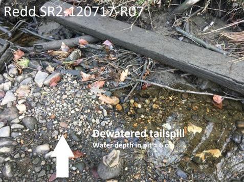

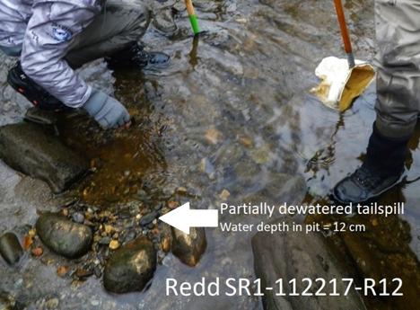
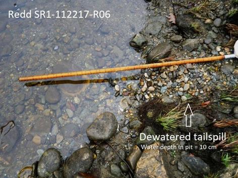
35 Figure 13. Examples of dewatering of redd tailspills in the Deerfield River in fall


36 Figure 14. Photographs of eyed eggs and alevins (yolk sac fry) collected from Deerfield River brown trout redds surveyed in March,
37 LITERATURE CITED Barnett, H. and D. Paige. Bull Trout and Pygmy Whitefish Spawning Survey Protocol. Seattle Public Utilities. Crisp, D. T A desk study of the relationship between temperature and hatching time for the eggs of five species of salmonid fishes. Freshwater Biology 11: Dunham, J. and B. Reiman Sources and magnitude of sampling error in redd counts for bull trout. North American Journal of Fisheries Management 21: Karen. E. Lohman, Kellie J. Carim, J. Caleb Dysthe and Michael K. Schwartz Species Assignment of Salmonid Redds in the Deerfield River Using Genetic Identification of Collected Eggs. Unpublished report prepared by the National Genomics Center for Wildlife and Fish Conservation. Missoula, MT. 6 pp. Reiser, D.W., and T.A. Wesche In situ freezing as a cause of mortality in brown trout eggs. Progressive Fish Culturist 41(2): Reiser, D.W., and R.G. White Incubation of steelhead trout and spring Chinook salmon eggs in a moist environment. Progressive Fish Culturist 43: Reiser, D.W., and R.G. White Effect of complete redd dewatering on salmonid egg-hatching success and development of juveniles. Transactions of the American Fisheries Society 112: Shirvell, C.S. and R.G. Dungey Microhabitats chosen by brown trout for feeding and spawning in rivers. Transactions of the American Fisheries Society 112: Skoog, M.L Brown Trout Spawning Location and Relationship to Suitable Winter Habitat. MS Thesis? Bemidji State University. Tiffan, K. F., Haskell, C. A.&Kock, T. J. (2010). Quantifying the behavioral response of spawning chum salmon to elevated discharges from Bonneville dam, Columbia River, USA. River Research and Applications 26, Vollset, Knut & Skoglund, Helge & Wiers, Tore & Barlaup, Bjørn Effects of hydropeaking on the spawning behaviour of Atlantic salmon Salmo salar and brown trout Salmo trutta. Journal of fish biology. 88: Witzel, L. D., and H.R. MacCrimmon Redd-site selection by brook trout and brown trout in southwestern Ontario streams. Transactions of the American Fisheries Society 112:
Journal of Freshwater Ecology. Volume 5
 Redd Site Selection by Brown Trout in Douglas Creek, Wyoming Richard T. Grost - Thomas A. Wesche Journal Article Wayne A. Hubert 99 WWRC-9-22 In Journal of Freshwater Ecology Volume 5 Richard T. Grost
Chinook Salmon Spawning Study Russian River Fall 2005
 Chinook Salmon Spawning Study Russian River Fall 2005 Sonoma County Water Agency 2150 West College Avenue Santa Rosa, California 95401 Prepared by David Cook - Senior Environmental Specialist March 27,
Job 1. Title: Estimate abundance of juvenile trout and salmon.
 STUDY PERFORMANCE REPORT State: Michigan Project No.: F-53-R-13 Study No.: 461 Title: Population dynamics of juvenile rainbow trout and coho salmon in Lake Superior tributaries Period Covered: April 1,
Minnesota Department of Natural Resources Division of Fish and Wildlife Section of Fisheries. Stream Survey Report. Luxemburg Creek.
 Minnesota F-29-R(P)-24 Area 315 Study 3 March 2016 Minnesota Department of Natural Resources Division of Fish and Wildlife Section of Fisheries Stream Survey Report Luxemburg Creek 2015 Mark Pelham Sauk
FISHERIES BLUE MOUNTAINS ADAPTATION PARTNERSHIP
 FISHERIES A warming climate, by itself, substantially affects the hydrology of watersheds in the Blue Mountains. Among the key hydrologic changes projected under all scenarios for the 2040s and beyond
August 11 Snorkel SCC side channel network (SBA, SCC3) feet 707
 feet 707") Date Survey Type Habitat July 29 Snorkel (reconnaissance) Table 1. Fish use survey schedule 2004 Water temperature 1 (ºC) Estimated Mean visibility 2 discharge 3 (cfs) Mainstem (units #1 42) ND ND 814
Date Survey Type Habitat July 29 Snorkel (reconnaissance) Table 1. Fish use survey schedule 2004 Water temperature 1 (ºC) Estimated Mean visibility 2 discharge 3 (cfs) Mainstem (units #1 42) ND ND 814
Final Bull Trout Redd Monitoring Report for the Wallowa Falls Hydroelectric Project
 Final for the Wallowa Falls Hydroelectric Project East Fork Wallowa River barrier to upstream fish migration, photo courtesy of Kendrick Moholt (FERC No. P-308) December 18, 2017 Prepared by: Jeremiah
2014 Winnebago System Walleye Report
 1986 1988 199 1992 1994 1996 1998 2 22 24 26 28 21 212 214 Number of YOY WAE / Trawl 214 Winnebago System Walleye Report Adam Nickel, Winnebago Gamefish Biologist, 18 March 215 The spring rush of 215 will
Redd Dewatering and Juvenile Salmonid Stranding in the Lower Feather River,
 Redd Dewatering and Juvenile Salmonid Stranding in the Lower Feather River, 2005-2006 Interim Report for NOAA Fisheries Prepared by: California Department of Water Resources Division of Environmental Services
Deschutes Bull Trout
 Deschutes Bull Trout Existing Populations The Deschutes Bull Trout SMU is comprised of eight populations, three of which are classified as extinct (Table 1). Populations are identified according to those
SUMMARY OF MOVEMENT AND HABITAT USED BY TAGGED BROOK TROUT IN THE MAIN BRANCH AND NORTH BRANCH AU SABLE RIVER DURING SUMMER Data Submitted to:
 SUMMARY OF MOVEMENT AND HABITAT USED BY TAGGED BROOK TROUT IN THE MAIN BRANCH AND NORTH BRANCH AU SABLE RIVER DURING SUMMER 2014 Data Submitted to: Anglers of the Au Sable Submitted by: Dr. Mark R. Luttenton
Juvenile Steelhead and Stream Habitat Conditions Steelhead and Coho Salmon Life History Prepared by: DW ALLEY & Associates, Fishery Consultant
 Juvenile Steelhead and Stream Habitat Conditions Steelhead and Coho Salmon Life History Prepared by: DW ALLEY & Associates, Fishery Consultant I-1. Steelhead and Coho Salmon Ecology Migration. Adult steelhead
Estimating Summer Steelhead Escapement using Redd Surveys: What have we learned and where do we go? Jim Ruzycki Oregon Department of Fish & Wildlife
 Estimating Summer Steelhead Escapement using Redd Surveys: What have we learned and where do we go? Jim Ruzycki Oregon Department of Fish & Wildlife Spawner Abundance for the John Day Summer Steelhead
STUDY PERFORMANCE REPORT
 STUDY PERFORMANCE REPORT State: Michigan Project No.: F-80-R-7 Study No.: 230654 Title: Evaluation of brown trout and steelhead competitive interactions in Hunt Creek, Michigan. Period Covered: October
Bushkill Creek Trout Redd Survey
 2016 Bushkill Creek Trout Redd Survey Brian Wagner Forks of the Delaware Trout Unlimited PO Box 467 Stockertown, PA 18083 12/4/2016 2016 Bushkill Creek Trout Redd Survey Goals: The Forks of the Delaware
SALMON FACTS. Chinook Salmon. Oncorhynchus tshawytscha
 SALMON FACTS Chinook Salmon Oncorhynchus tshawytscha Other names: king, tyee, blackmouth (immature) Average size: 10-15 lbs, up to 135 lbs Fall spawner; fall, spring, and summer runs Chinook salmon are
ACUTE TEMPERATURE TOLERANCE OF JUVENILE CHINOOK SALMON FROM THE MOKELUMNE RIVER
 ACUTE TEMPERATURE TOLERANCE OF JUVENILE CHINOOK SALMON FROM THE MOKELUMNE RIVER Charles H. Hanson, Ph.D. Hanson Environmental, Inc. SUMMARY A series of static acute tests were performed to determine the
THE CONFEDERATED TRIBES OF THE WARM SPRINGS RESERVATION OF OREGON
 THE CONFEDERATED TRIBES OF THE WARM SPRINGS RESERVATION OF OREGON To: Branch of Natural Resources P.0. Box C, Warm Springs, Oregon 97761 Phone (541) 553-2002/2003 Fax (541) 553-1994 The Independent Science
Columbia Lake Dam Removal Project
 Columbia Lake Dam Removal Project The Columbia Lake dam located 1/4 mile upstream of the Paulins Kill River's confluence with the Delaware River in Knowlton Township, Warren County has been proposed for
NEVADA DEPARTMENT OF WILDLIFE STATEWIDE FISHERIES MANAGEMENT
 NEVADA DEPARTMENT OF WILDLIFE STATEWIDE FISHERIES MANAGEMENT FEDERAL AID JOB PROGRESS REPORTS F-20-52 2016 Lake Tahoe Rainbow Trout Study WESTERN REGION NEVADA DEPARTMENT OF WILDLIFE, FISHERIES DIVISION
Abundance of Steelhead and Coho Salmon in the Lagunitas Creek Drainage, Marin County, California
 scanned for KRIS Abundance of Steelhead and Coho Salmon in the Lagunitas Creek Drainage, Marin County, California Prepared for: Marin Municipal Water District 220 Nellen Drive Corte Madera, California
Stony Creek Creel Census
 Stony Creek Creel Census conducted for Division of Fisheries Illinois Department of Conservation 600 North Grand Ave. West Springfield, IL 62706 by R. Weldon Larimore, Principal Investigator Jack A. Swanson,
Spokane River Fish and Flows Recommendations and Rationale September Hal Beecher Washington Department of Fish and Wildlife
 Spokane River Fish and Flows Recommendations and Rationale September 2012 Hal Beecher Washington Department of Fish and Wildlife Spokane River hydrology and channel: Background Modified hydrology, but
Final Bull Trout Genetics Monitoring Plan for the Wallowa Falls Hydroelectric Project. (FERC No. P-308) June 2017
 June 2017") Final for the Wallowa Falls Hydroelectric Project (FERC No. P-308) June 2017 Prepared by: Jeremiah Doyle PacifiCorp 825 NE Multnomah Street Portland, OR 97232 June, 2017 Page 1 of 8 Table of Contents 1.0
Final for the Wallowa Falls Hydroelectric Project (FERC No. P-308) June 2017 Prepared by: Jeremiah Doyle PacifiCorp 825 NE Multnomah Street Portland, OR 97232 June, 2017 Page 1 of 8 Table of Contents 1.0
2015 Winnebago System Walleye Report
 215 Winnebago System Walleye Report Adam Nickel, Winnebago Gamefish Biologist, March 216 As winter passes in the rear view mirror, it won t be long until the spring rush of the 216 walleye run is here.
Study No. 18. Mystic Lake, Montana. PPL Montana 45 Basin Creek Road Butte, Montana 59701
 Study No. 18 Evaluation of the Current Fish Population and Habitat in West Rosebud Creek Downstream from Emerald Lake Mystic Lake Hydroelectric Project FERC No. 2301 Mystic Lake, Montana PPL Montana 45
Don Pedro Project Relicensing
 Don Pedro Project Relicensing M ODESTO I RRIGATION D ISTRICT TURLOCK I RRIGATION D ISTRICT FERC PROJECT N O. 2299 Resident Fish in Don Pedro Reservoir Don Pedro Reservoir Fish Stocking (1971-Present) CDFG
Final Fish Salvage & Temporary Tailrace Barrier Report for the Wallowa Falls Hydroelectric Project Tailrace. (FERC No. P-308) December 18, 2017
 December 18, 2017") Final for the Wallowa Falls Hydroelectric Project Tailrace (FERC No. P-308) December 18, 2017 Prepared by: Jeremiah Doyle PacifiCorp 825 NE Multnomah Street Portland, OR 97232 December 18, 2017 Page 1
Final for the Wallowa Falls Hydroelectric Project Tailrace (FERC No. P-308) December 18, 2017 Prepared by: Jeremiah Doyle PacifiCorp 825 NE Multnomah Street Portland, OR 97232 December 18, 2017 Page 1
JOINT STAFF REPORT WINTER FACT SHEET NO. 9 Columbia River Compact March 18, 2004
 JOINT STAFF REPORT WINTER FACT SHEET NO. 9 Columbia River Compact March 18, 2004 Purpose: To review ongoing commercial fisheries and consider non-indian commercial fishing seasons for salmon, smelt and
Packwood Lake Intake Screen Velocity Test Report for Energy Northwest's Packwood Lake Hydroelectric Project FERC No Lewis County, Washington
 for Energy Northwest's Packwood Lake Hydroelectric Project FERC No. 2244 Lewis County, Washington Submitted to P.O. Box 968 Richland, Washington 99352-0968 Submitted by EES Consulting 1155 North State
Packwood Hydroelectric Project Barrier Analysis December 12, 2006
 Packwood Hydroelectric Project Barrier Analysis December 12, 2006 Study Area Natural barriers to upstream fish passage on Lake Creek at RM 1.03 and RM 1.95 Snyder Creek culvert under the Project tailrace
Final Fish Salvage & Temporary Tailrace Barrier Report for the Wallowa Falls Hydroelectric Project Tailrace. (FERC No. P-308) December 20, 2018
 December 20, 2018") Final Fish Salvage & Temporary Tailrace Barrier Report for the Wallowa Falls Hydroelectric Project Tailrace (FERC No. P-308) December 20, 2018 Prepared by: Jeremiah Doyle PacifiCorp 825 NE Multnomah Street
Final Fish Salvage & Temporary Tailrace Barrier Report for the Wallowa Falls Hydroelectric Project Tailrace (FERC No. P-308) December 20, 2018 Prepared by: Jeremiah Doyle PacifiCorp 825 NE Multnomah Street
Fraser River. FISH SURVEY AND MANAGEMENT INFORMATION Jon Ewert - Aquatic Biologist (Hot Sulphur Springs)
") Fraser River FISH SURVEY AND MANAGEMENT INFORMATION Jon Ewert - Aquatic Biologist (Hot Sulphur Springs) General Information: The Fraser River is a highly diverse river offering many transitions in habitat
Fraser River FISH SURVEY AND MANAGEMENT INFORMATION Jon Ewert - Aquatic Biologist (Hot Sulphur Springs) General Information: The Fraser River is a highly diverse river offering many transitions in habitat
Alberta Conservation Association 2017/18 Project Summary Report
 Alberta Conservation Association 2017/18 Project Summary Report Project Name: Abundance, Distribution, Spawning, and Thermal Habitat of Westslope Cutthroat Trout and Bull Trout in the Stimson Creek Watershed
Winnebago System Walleye Report. Adam Nickel, Winnebago System Gamefish Biologist, August 2018
 2017-18 Winnebago System Walleye Report Adam Nickel, Winnebago System Gamefish Biologist, August 2018 The Winnebago System continues to boast a self-sustaining walleye population that serves as one of
Fish Survey Report and Stocking Advice for Loch Milton. (Loch a Mhuilinn), May 2011
, May 2011") Fish Survey Report and Stocking Advice for Loch Milton (Loch a Mhuilinn), May 2011 Jonah Tosney Freshwater Fisheries Biologist Wester Ross Fisheries Trust 1 Loch Milton (Loch a Mhuilinn) Fish Survey Report
Fish Survey Report and Stocking Advice for Loch Milton (Loch a Mhuilinn), May 2011 Jonah Tosney Freshwater Fisheries Biologist Wester Ross Fisheries Trust 1 Loch Milton (Loch a Mhuilinn) Fish Survey Report
Interim Guidance Fish Presence Absence
 Interim Guidance Fish Presence Absence Source: Forest Practices Act Guidance for Division 635 of the forest practices act dealing with stream classification when no fish surveys have been done (referenced
Appendix A Recommended EPA Temperature Thresholds for use in Establishing Thermal Potential and Species Life Stage Numeric Criteria
 Appendix A Recommended EPA Temperature Thresholds for use in Establishing Thermal Potential and Species Life Stage Numeric Criteria 1. Temperature Limits Recommended to Protect Salmonid Guilds In this
2013 Electrofishing Program Summary. Miramichi Salmon Association In collaboration with the Department of Fisheries and Oceans
 2013 Electrofishing Program Summary Miramichi Salmon Association In collaboration with the Department of Fisheries and Oceans Prepared by: Alex Parker Biologist Miramichi Salmon Association 485, Route
Study Update Tailrace Slough Use by Anadromous Salmonids
 Study Update Tailrace Slough Use by Anadromous Salmonids Goals and Objectives Identify what anadromous salmonids use the tailrace slough by: Life Stage (Juvenile, migrating and spawning adults) Timing
Firth Creek Habitat Enhancement Project 1993
 Firth Creek Habitat Enhancement Project 1993 A. R. Langston December 1993 PWFWCP Report No. 77 The Peace/Williston Fish & Wildlife Compensation Program is a cooperative venture of BC Hydro and the provincial
Cove Point Beach Restoration: Utilization of a Spawning Habitat by Horseshoe Crabs (Limulus polyphemus)
") Cove Point Beach Restoration: Utilization of a Spawning Habitat by Horseshoe Crabs (Limulus polyphemus) Paul Bushmann, Jessica Peterson, Bethany Enyeart and Deborah Smith Anne Arundel Community College
Cove Point Beach Restoration: Utilization of a Spawning Habitat by Horseshoe Crabs (Limulus polyphemus) Paul Bushmann, Jessica Peterson, Bethany Enyeart and Deborah Smith Anne Arundel Community College
EXHIBIT ARWA-700 TESTIMONY OF PAUL BRATOVICH
 EXHIBIT ARWA-700 TESTIMONY OF PAUL BRATOVICH 1. I am a fisheries biologist employed by the firm of HDR, Inc. I hold a Bachelor of Science degree in Fisheries from the University of Washington, located
Five Counties Salmonid Conservation Program - Fish Passage Design Workshop. February 2013
 Program - Aquatic Organisms and Stream Crossings Ecological Connectivity A watershed is a network of channels that drain a common boundary. Channel characteristics formed by interaction of precipitation,
NEVADA DEPARTMENT OF WILDLIFE STATEWIDE FISHERIES MANAGEMENT
 NEVADA DEPARTMENT OF WILDLIFE STATEWIDE FISHERIES MANAGEMENT FEDERAL AID JOB PROGRESS REPORTS F-20-52 2016 EAST FORK AND MAIN STEM CARSON RIVER WESTERN REGION NEVADA DEPARTMENT OF WILDLIFE, FISHERIES DIVISION
Lewis River Bull Trout Habitat Restoration Project Identification Assessment
 Lewis River Bull Trout Habitat Restoration Project Identification Assessment Jamie Lamperth 1, Bryce Michaelis 2, and Abi Groskopf 3 1 Washington Department of Fish and Wildlife, Fish Ecology and Life
Columbia Lake Dam Removal Project
 Columbia Lake Dam Removal Project Major Goals of the Columbia Lake Dam Removal: Reconnect 10 miles of the Paulins Kill River to the Delaware River, restoring natural flow regime and sediment transport.
2017 Lake Winnebago Bottom Trawling Assessment Report
 217 Lake Winnebago Bottom Trawling Assessment Report Adam Nickel, Winnebago System Gamefish Biologist, March 218 There were several highlights from the 217 Lake Winnebago bottom trawling survey, including
Project Name: Distribution of Sport Fish in the Waterton River Tailwater, 2014
 Alberta Conservation Association (ACA) Date: 2014-2015 Project Name: Distribution of Sport Fish in the Waterton River Tailwater, 2014 Fisheries Program Manager: Peter Aku Project Leader: Jason Blackburn
Minnesota Department of Natural Resources Fisheries Division, Lake Superior Area
 Minnesota F-9-R(P)- Study 4 Job 616 Minnesota Department of Natural Resources Fisheries Division, Lake Superior Area Coaster Brook Trout Status in Minnesota-Lake Superior Tributaries Following Regulation
Big Spring Creek Habitat Enhancement and Fishery Management Plans
 Big Spring Creek Habitat Enhancement and Fishery Management Plans November 5, 2012 Big Spring Events and Activities Center Newville, PA Charlie McGarrell Regional Habitat Biologist Pennsylvania Fish and
STEELHEAD SURVEYS IN OMAK CREEK
 STEELHEAD SURVEYS IN OMAK CREEK 2002 Annual Report Prepared by Chris Fisher John Arterburn Colville Confederated Tribes Fish and Wildlife Department P.O. Box 150 Nespelem, WA 99155 Prepared for Project
APPENDIX B. Final reports on chinook salmon spawning surveys - Sultan River, Washington Report
 APPENDX B Final reports on chinook salmon spawning surveys - Sultan River, Washington B-1. B-2. 1987 Report. 1988 Report APPENDX B-l Final report on 1987 chinook spawning survey - Sultan River, Snohomish
STUDY PERFORMANCE REPORT
 STUDY PERFORMANCE REPORT State: Michigan Project No.: F-53-R-14 Study No.: 486 Title: Assessment of lake trout populations in Michigan s waters of Lake Michigan. Period Covered: April 1, 1997 to March
Klamath Lake Bull Trout
 Klamath Lake Bull Trout Existing Populations The Klamath Lake Bull Trout SMU is comprised of seven existing populations and four populations classified as extinct or functionally extinct (Table 189). Populations
MINISTRY OF ENVIRONMENT ENVIRONMENTAL STEWARDSHIP DIVISION FISH AND WILDLIFE BRANCH. Horsefly River Angling Management Plan
 MINISTRY OF ENVIRONMENT ENVIRONMENTAL STEWARDSHIP DIVISION FISH AND WILDLIFE BRANCH Horsefly River Angling Management Plan January 30 th, 2006 Area/Fishery Description The Horsefly River watershed provides
Brook Trout Life Cycle and Habitat
 Brook Trout Life Cycle and Habitat Directions: 1. As you watch this slide show, watch for vocabulary terms we learned today. The first time they appear, you will see them in RED! (not redd!) 2. At the
COLUMBIA LAKE DAM REMOVAL PROJECT
 COLUMBIA LAKE DAM REMOVAL PROJECT Major Goals of the Columbia Lake Dam Removal: Reconnect 10 miles of the Paulins Kill River to the Delaware River, restoring natural flow regime and sediment transport.
Minnesota Department of Natural Resources Division of Fish and Wildlife Section of Fisheries. Stream Survey Report. Cold Spring Creek.
 Minnesota F-29-R(P)-24 Area 315 Study 3 March 2015 Minnesota Department of Natural Resources Division of Fish and Wildlife Section of Fisheries Stream Survey Report Cold Spring Creek 2014 Mark Pelham Montrose
Salmon Biology Station
 Salmon Biology Station OBJECTIVES: Students learn: Wild salmon are indicator species and keystone species whose survival is connected to the health of the watershed. o Riparian salmon need trees and trees
ASSESSMENT OF THE STATUS OF NESTUCCA RIVER WINTER STEELHEAD
 ASSESSMENT OF THE STATUS OF NESTUCCA RIVER WINTER STEELHEAD Gary Susac and Steve Jacobs Coastal Salmonid Inventory Project Oregon Department of Fish and Wildlife August 21, 2001 INTRODUCTION This report
NEVADA DIVISION OF WILDLIFE STATEWIDE FISHERIES MANAGEMENT FEDERAL AID JOB PROGRESS REPORTS F YELLOWSTONE CUTTHROAT TROUT EASTERN REGION
 NEVADA DIVISION OF WILDLIFE STATEWIDE FISHERIES MANAGEMENT FEDERAL AID JOB PROGRESS REPORTS F-20-48 2012 YELLOWSTONE CUTTHROAT TROUT EASTERN REGION NEVADA DEPARTMENT OF WILDLIFE, FISHERIES DIVISION ANNUAL
1998 Willow Creek Downstream Migrant Trap Report. Draft. Prepared By: C. A. Walker. Lower Trinity Ranger District. Six Rivers National Forest
 1998 Willow Creek Downstream Migrant Trap Report Draft Prepared By: C. A. Walker Lower Trinity Ranger District Six Rivers National Forest September 1998 Executive Summary The downstream migrant trap was
***Please Note*** April 3, Dear advisory committee members:
 April 3, 29 Dear advisory committee members: The fifth meeting of the CHF advisory committee will be held April 13 in Grants Pass from 6:-8:3 PM, and the purpose of this document is to help committee members
Upper Yuba River Watershed Chinook Salmon and Steelhead Habitat Assessment
 Technical Report Upper Yuba River Watershed Chinook Salmon and Steelhead Habitat Assessment Prepared for California Department of Water Resources November 2007 Prepared by Upper Yuba River Studies Program
A PROJECT OF THE ANN ARBOR CHAPTER OF MICHIGAN TROUT UNLIMITED
 ESTABLISHING A TROUT FISHERY IN MILL CREEK A PROJECT OF THE ANN ARBOR CHAPTER OF MICHIGAN TROUT UNLIMITED A REPORT PREPARED BY THE MILL CREEK FISHERY DEVELOPMENT COMMITTEE: THOMAS EDSALL 1, CARLOS FETTEROLF
REVISED DRAFT HABITAT SUITABILITY CURVES and COHO SALMON and STEELHEAD TROUT. Sawmill Creek Alaska
 REVISED DRAFT HABITAT SUITABILITY CURVES and COHO SALMON and STEELHEAD TROUT Sawmill Creek Alaska Blue Lake Hydroelectric Project, FERC No. 2230, Relicensing Prepared by: City and Borough of Sitka ( City
Results of the 2015 nontidal Potomac River watershed Smallmouth Bass Young of Year Survey
 Results of the 2015 nontidal Potomac River watershed Smallmouth Bass Young of Year Survey Natural reproduction of smallmouth bass in the nontidal Potomac River mainstem has been assessed annually since
Catlow Valley Redband Trout
 Catlow Valley Redband Trout Existing Populations The Catlow Valley Redband Trout SMU is comprised of five populations (Table 1). Three exist in Home, Threemile, and Skull creeks, located on the east side
Lake Merwin and Swift Creek Reservoir Tributaries. Bull Trout Limiting Factors Analysis
 Lake Merwin and Swift Creek Reservoir Tributaries Bull Trout Limiting Factors Analysis Study Objectives Answer Key? s Do other tributaries to Swift Creek Reservoir and Lake Merwin not known to support
MEMORANDUM. Ron Boyce, ODFW Bob Heinith, CRITFC. Michele DeHart. DATE: November 30, Operations
 FISH PASSAGE CENTER 1827 NE 44 th Ave., Suite 240, Portland, OR 97213 Phone: (503) 230-4099 Fax: (503) 230-7559 http://www.fpc.org/ e-mail us at fpcstaff@fpc.org MEMORANDUM TO: Ron Boyce, ODFW Bob Heinith,
The Salmonid Species. The Salmonid Species. Definitions of Salmonid Clans. The Salmonid Species
 The Salmonid Species The Salmonid Species N. American salmon (2 more Asian species) Chinook ( King ) Coho ( Silver ) Sockeye Chum ( Dog ) Pink ( Humpy ) Sea-run trout Steelhead, Cutthroat, Dolly Varden
Yale Reservoir Kokanee (Oncorhynchus nerka) Escapement Report 2016
 Escapement Report 2016") Yale Reservoir Kokanee (Oncorhynchus nerka) Escapement Report 2016 North Fork Lewis River Hydroelectric Project Yale FERC No. 2071 Prepared by: Jeremiah Doyle, PacifiCorp April 4, 2017 1.0 INTRODUCTION
Yale Reservoir Kokanee (Oncorhynchus nerka) Escapement Report 2016 North Fork Lewis River Hydroelectric Project Yale FERC No. 2071 Prepared by: Jeremiah Doyle, PacifiCorp April 4, 2017 1.0 INTRODUCTION
Warden Tom Kasnick August 30, 1983
 scanned for KRIS Franz Creek Warden Tom Kasnick August 30, 1983 - Region 3 Franz Creek, Sonoma County - Fish Kill and Pollution Incident On August 3, 1983, you requested that I investigate a reported fish
2017 Fall Zone 4-5 Gillnet Fishery WDFW and ODFW Observation Study Sampling Plan
 2017 Fall Zone 4-5 Gillnet Fishery WDFW and ODFW Observation Study Sampling Plan Introduction Columbia River fisheries generate millions of dollars in economic value annually, and are an integral part
RIVER CONONISH INVERTEBRATE SURVEY Dr Kjersti Birkeland
 RIVER CONONISH INVERTEBRATE SURVEY 26 Dr Kjersti Birkeland Background The Cononish, the upper reaches of the River Dochart, should be very important for spring salmon but surveys by the Tay District Salmon
What was the historic coaster fishery like?
 1 of 6 1/30/2012 12:25 PM Home About Topics Contact Us Fishing Calendar Fish ID Tips FAQs Hack Noyes Research Vessel Is it a unique strain long lost from Wisconsin's shoreline? Fisheries Reports Tributaries
Scour of Chinook Salmon Redds on Suction Dredge Tailings
 North American Journal of Fisheries Management 19:613-617, 1999 American Fisheries Society 1999 Scour of Chinook Salmon Redds on Suction Dredge Tailings BRET C. HARVEY* AND THOMAS E. LISLE Pacific Southwest
Monitoring of sea trout post-smolts, 2012
 Monitoring of sea trout post-smolts, 2012 A report to the West Sutherland Fisheries Trust, Report No. WSFT2/13 January 2013 Shona Marshall Fisheries Biologist West Sutherland Fisheries Trust Gardeners
Lesson 3-2: Nechako White Sturgeon Life Cycle
 Unit 3: The Nechako White Sturgeon - our prehistoric giant 3-14 Lesson 3-2: Nechako White Sturgeon Life Cycle Time of Lesson: 1.5 hours Rationale: The purpose of this lesson is to introduce the life cycle
ELECTRO-FISHING REPORT 2016 UPPER TWEED
 ELECTRO-FISHING REPORT 2016 UPPER TWEED The electro-fishing programme carried out each summer by The Tweed Foundation is part of our management plan, which details the information that is required to manage
Oregon Hatchery Research Center January 2014 David L. G. Noakes, Professor & Director
 Oregon Hatchery Research Center January 2014 David L. G. Noakes, Professor & Director Research Proposal Homing Homing behavior is a striking feature of the biology of Pacific salmon, and is the basis for
Removal of natural obstructions to improve Atlantic Salmon and Brook Trout habitat in western NL. 26/02/2015 Version 2.0
 Removal of natural obstructions to improve Atlantic Salmon and Brook Trout habitat in western NL 26/02/2015 Version 2.0 1 Table of Contents List of Tables... 2 Introduction... 3 Methods... 4 Preliminary
Jason Blackburn, Paul Hvenegaard, Dave Jackson, Tyler Johns, Chad Judd, Scott Seward and Juanna Thompson
 Alberta Conservation Association (ACA) Date: 2014-2015 Project Name: Owl River Walleye and Aquatic Habitat Assessment Fisheries Program Manager: Peter Aku Project Leader: Tyler Johns Primary ACA staff
A.23 RIVER LAMPREY (LAMPETRA
 A. RIVER LAMPREY (LAMPETRA AYRESII) A.. Legal and Other Status The river lamprey is a Class (Watch List) California Species of Special Concern (Moyle et al., DFG 0). It has no federal status. A.. Species
INITIATION OF FEEDING DURING HATCHERY REARING OF LANDLOCKED FALL CHINOOK SALMON FRY
 Proceedings of the South Dakota Academy of Science, Vol. 81 (2002) 137 INITIATION OF FEEDING DURING HATCHERY REARING OF LANDLOCKED FALL CHINOOK SALMON FRY Michael E. Barnes, William A. Sayler, and Rick
NATIVE FISH CONSERVATION PLAN FOR THE SPRING CHINOOK SALMON ROGUE SPECIES MANAGEMENT UNIT
 Attachment 4 NATIVE FISH CONSERVATION PLAN FOR THE SPRING CHINOOK SALMON ROGUE SPECIES MANAGEMENT UNIT Figures in Draft Plan of February 28, 27 Figure 1. Map of the Rogue River Basin. PASSAGE ESTIMATES
Hatcheries: Role in Restoration and Enhancement of Salmon Populations
 Hatcheries: Role in Restoration and Enhancement of Salmon Populations Hatcheries play a large role in the management, ecology, and evolution of Pacific salmon. Why were/are they built? What are the assumptions
Summer Steelhead Surveys North Fork Trinity River Trinity County, California
 KRIS edition Summer Steelhead Surveys North Fork Trinity River Trinity County, California 1978-1997 By Loren Everest Fishery Biologist Weaverville Ranger District Shasta-Trinity National Forests October
NORTH RIVER FISH KILL PRELIMINARY REPORT 2014 SUMMARY
 NORTH RIVER FISH KILL PRELIMINARY REPORT 2014 SUMMARY A fish kill on Nor River was reported to e 1-800 Environmental emergency number on August 9, 2014. Representatives from e PEI Department of Environment,
Data Report : Russian River Basin Steelhead and Coho Salmon Monitoring Program Pilot Study
 Data Report 1999-1: Russian River Basin Steelhead and Coho Salmon Monitoring Program Pilot Study Sonoma County Water Agency 215 West College Avenue Santa Rosa, California 951 Prepared by David Cook Senior
Fish Habitat Restoration and Monitoring in Southeast Washington. Andy Hill Eco Logical Research, Inc.
 Fish Habitat Restoration and Monitoring in Southeast Washington Andy Hill Eco Logical Research, Inc. Fish Habitat Restoration and Monitoring in Southeast Washington Talk overview: Restoration projects
Cedar Lake Comprehensive Survey Report Steve Hogler and Steve Surendonk WDNR-Mishicot
 Cedar Lake- 2006 Comprehensive Survey Report Steve Hogler and Steve Surendonk WDNR-Mishicot ABSTRACT Cedar Lake is a 142 acre lake located in the southwest corner of Manitowoc County. It is a seepage lake
ENTRANCES USED AND PASSAGE THROUGH FISHWAYS FOR ADULT CHINOOK SALMON AND STEELHEAD
 ENTRANCES USED AND PASSAGE THROUGH FISHWAYS FOR ADULT CHINOOK SALMON AND STEELHEAD Part III of Final Report for MIGRATION OF ADULT CHINOOK SALMON AND STEELHEAD PAST DAMS AND THROUGH RESERVOIRS IN THE LOWER
WFC 50 California s Wild Vertebrates Jan. 11, Inland Waters (Lakes and Streams) Lisa Thompson
 Lisa Thompson") Inland Waters: Lakes and Streams WFC 50 11 January 2011 Lisa Thompson Fisheries Extension Specialist Wildlife, Fish, & Conservation Biology Department University of California, Davis Take home messages
Inland Waters: Lakes and Streams WFC 50 11 January 2011 Lisa Thompson Fisheries Extension Specialist Wildlife, Fish, & Conservation Biology Department University of California, Davis Take home messages
OKANAGAN RIVER RESTORATION INITIATIVE - FAQ
 OKANAGAN RIVER RESTORATION INITIATIVE - FAQ Initiative background: The health of the q awsitk w (Okanagan River) has been severely impacted by the channelization works that occurred in the mid-1950 s.
Salmon and Steelhead in the American River Tim Horner, PhD Geology Department California State University, Sacramento
 Salmon and Steelhead in the American River Tim Horner, PhD Geology Department California State University, Sacramento What kind of fish are in the American River? The American River provides habitat for
MINNESOTA DEPARTMENT OF NATURAL RESOURCES DIVISION OF FISHERIES AND WILDLIFE. Gamefish Assessment Report
 Minnesota DNR F-29-R(P) Area F312 February 1, 2013 MINNESOTA DEPARTMENT OF NATURAL RESOURCES DIVISION OF FISHERIES AND WILDLIFE Gamefish Assessment Report Spring Gamefish Assessment on the Mississippi
Salmon in the classroom
 Salmon in the classroom Lochaber Fisheries Trust Registered Office: Torlundy Training Centre, Torlundy, Fort William, Inverness-shire. PH33 6SW Telephone: 01397 703 728 Company Registration Number: 261
ASMFC Stock Assessment Overview: Red Drum
 Introduction This document presents a summary of the 217 stock assessments for red drum. These assessments were initially conducted through the Southeast Data, Assessment and Review (SEDAR) process using