JUVENILE SALMONID POPULATION MONITORING REPORT LAGUNITAS CREEK MARIN COUNTY, CALIFORNIA FALL 1997
|
|
|
- Alice Osborne
- 5 years ago
- Views:
Transcription
1 JUVENILE SALMONID POPULATION MONITORING REPORT LAGUNITAS CREEK MARIN COUNTY, CALIFORNIA FALL 1997 Prepared By: Gregory M. Andrew, Fishery Biologist and Michael L. Cronin, Fishery Biologist Aide Marin Municipal Water District 220 Nellen Avenue Corte Madera, CA (415) February 1998
2 TABLE OF CONTENTS EXECUTIVE SUMMARY...ES INTRODUCTION METHODS RESULTS HABITAT DESCRIPTIONS Lagunitas Creek San Geronimo Creek Devils Gulch STREAM HABITAT TYPES FISH SAMPLING RESULTS Coho and Steelhead Catch Summary Steelhead Age Classes SALMONID POPULATION ESTIMATES Juvenile Population Estimates Juvenile Population Trends DISCUSSION AND CONCLUSIONS REFERENCES...16 FIGURES and TABLES: Figure 1. Figure 2. Figure 3. Figure 4. Figure 5. Figure 6. Figure 7. Figure 8. Juvenile salmonid sample site locations...17 Overall habitat composition and percentage of habitat surveyed in Lagunitas Creek - Segment Overall habitat composition and percentage of habitat surveyed in Lagunitas Creek - Segment Overall habitat composition and percentage of habitat surveyed in San Geronimo Creek...20 Overall habitat composition and percentage of habitat surveyed in Devil s Gulch...21 Length frequency of all steelhead captured...22 Coho density in Lagunitas Creek, San Geronimo Creek, and Devil s Gulch by year...23 Steelhead density in Lagunitas Creek, San Geronimo Creek, and Devil s Gulch by year...24 i
3 Table of Contents (Continued) Table 1. Comparison of total salmonid catch for Table 2. Size breaks between 0+ and 1+ steelhead at each sample site...26 Table 3. Comparison of total population estimates...27 Table 4. Fish per 30 meters of stream for Lagunitas Cr., San Geronimo Cr., and Devil s Gulch...28 APPENDICES Appendix A: 1997 Fish Catch By Sample Site... A-1 Appendix B: 1997 Population Estimates By Sample Site for Salmonids...B-1 Appendix C: 1997 Extrapolated Population Estimates By Reach for Salmonids... C-1 Appendix D: Appendix E: Comparison of 1997 Extrapolated Population Estimates for San Geronimo Creek into Two Segments... D Field Survey Data...E-1 ii
4 EXECUTIVE SUMMARY Marin Municipal Water District (MMWD) staff conducted an electrofishing survey for coho salmon and steelhead trout in Lagunitas Creek and two of its main tributaries, San Geronimo Creek and Devil s Gulch, between 30-Sept-97 and 15-Oct-97. This survey is conducted annually and was performed in accordance with MMWD s Aquatic Resources Monitoring Workplan for the Lagunitas Creek Drainage, Marin County, California: Final Report (MMWD 1996). Sampling was conducted at twelve pre-established sample sites, seven in the mainstem of Lagunitas Creek, three in San Geronimo Creek and two in Devil s Gulch. Capture data from our sampling effort were used to compute population estimates as total abundance and densities (fish per unit length of stream) for coho and steelhead. Our results were compared to similar surveys conducted between 1970 and 1996 to tract trends in the coho and steelhead populations over time. Habitat conditions at the twelve sample sites was documented and found to be similar, but not necessarily identical, to the survey conducted in We determined that variations between survey results between 1996 and 1997 were not due to variations in habitat conditions at the sample sites. We also determined that a similar level of sampling effort was performed in 1997 as in Variations in the results were likely due to variations in the juvenile salmonid populations. However, we recommend an additional sample site be added to San Geronimo Creek, in the lower portion of the creek, to better represent salmonid utilization throughout San Geronimo Creek. A total of 541 juvenile coho were captured from all sites during our survey and we estimate a population of 16,962 juvenile coho in the system. In 1997, coho were present in much higher numbers at the tributary sample sites than at the sites in the mainstem of Lagunitas Creek. This may have been due to a loss of coho eggs during a large winter storm in early January, 1997 which may have destroyed coho redds in the mainstem of Lagunitas Creek. Nonetheless, the 1997 juvenile coho population appears to be maintained as a strong year class, which occurs in three year cycles and is represented by the 1988 and 1994 juvenile coho populations (no data from 1991). The results from 1997 indicate that the tributary streams may be very important for survival of coho eggs and rearing of juvenile coho in the Lagunitas Creek system. We captured 1,309 juvenile steelhead, consisting of 1,226 young-of-the-year (0+steelhead) and 83 older steelhead (1+steelhead, 1-3 years old). We also estimated between 47,000 and 53,000 juvenile steelhead in the Lagunitas Creek system. This year, the population of steelhead appeared to be much higher in the mainstem of Lagunitas Creek than in the tributaries, but this is not a consistent trend. The 1997 juvenile steelhead population estimate was the highest estimated in the period 1993 to 1997, although not dramatically higher than in most years in that period. The juvenile coho and steelhead populations sampled in 1997 appear to be keeping with an overall upward trend of the salmonid populations in the Lagunitas Creek system. This trend has been noted over the past several years of monitoring, between 1993 and Certainly for coho, the year class represented by the 1994 and 1997 juveniles was a strong year class. While not has high as in 1994, the abundance and density of juvenile coho estimated in 1997 was the second highest in all the years of surveys since ΕΣ 1
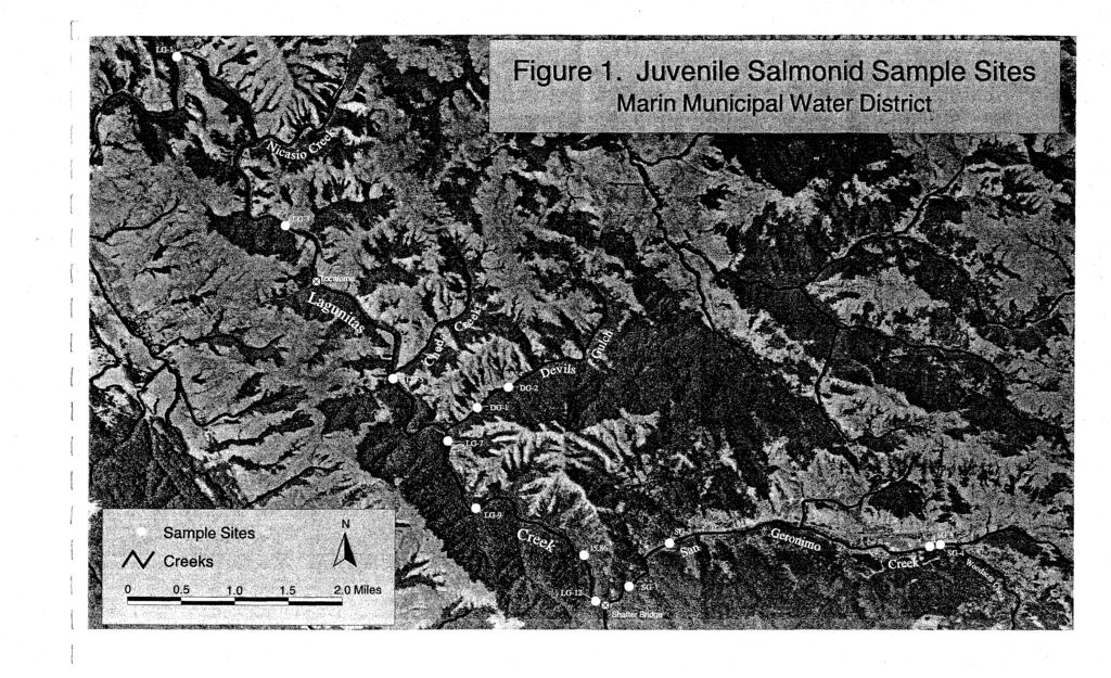
5 1.0 INTRODUCTION The Marin Municipal Water District (MMWD) is a public agency which diverts water from the Lagunitas Creek drainage in Marin County, California to provide a water supply for over 170,000 residents in southern and central Marin County. These diversions are permitted and regulated by the California State Water Resources Control Board (SWRCB). In its 1995 Order WR95-17, the SWRCB ordered MMWD to develop and implement a fisheries monitoring workplan as well as a sediment and riparian management plan for the Lagunitas Creek watershed (SWRCB 1995). In 1996, MMWD prepared the Aquatic Resources Monitoring Workplan for the Lagunitas Creek Drainage, Marin County, California: Final Report (MMWD 1996). In 1997, MMWD prepared the Lagunitas Creek Sediment and Riparian Management Plan: Final (MMWD 1997). One element of MMWD s aquatic resources monitoring workplan is to conduct annual surveys for juvenile salmonids in Lagunitas Creek. These surveys are being conducted to monitor coho salmon and steelhead trout populations in the Lagunitas Creek system and have been an ongoing effort by MMWD for many years. Population sampling for coho salmon and steelhead trout was first conducted in the Lagunitas Creek system in 1970 at sites established by the California Department of Fish and Game (CDFG). Several of these sites were sampled nearly every year during the 1980's except for 1981 and Since 1993, juvenile salmonid sampling has been conducted annually by MMWD. In 1983, MMWD began summer stream flow augmentation for the fishery resources downstream of Peters Dam. In addition to summer flow augmentation, MMWD has increased flows in Lagunitas Creek to aid in adult salmonid passage during the fall and winter spawning season. MMWD monitors stream flow at two gaging stations located in the mainstem of Lagunitas Creek and at a third gage located in San Geronimo Creek (a major tributary to Lagunitas Creek). MMWD also monitors water temperatures at one of the stream gages located on Lagunitas Creek. Abundance of steelhead and coho salmon in the Lagunitas Creek system has fluctuated widely between 1970 and 1996 with an overall decline from historic populations. Throughout California and the Pacific Northwest coho salmon and steelhead have steadily declined. Reasons for the decline include droughts, floods, and habitat degradation due to man s influence. This decline resulted in the threatened listing for coho salmon and steelhead by the National Marine Fisheries Service under the Federal Endangered Species Act. However, the abundance of both coho and steelhead in Lagunitas Creek have shown recent increases. The increases may be due in part to stream flow releases being maintained by MMWD and due to efforts by MMWD and others to reduce sedimentation and improve habitat conditions in the Lagunitas Creek watershed. This report covers the 1997 juvenile coho and steelhead population sampling effort. The survey was completed by MMWD staff during the Fall, 1997 at seven sampling sites in the mainstem of Lagunitas Creek as well as three sites in San Geronimo Creek and two sites in Devil s Gulch (another major tributary to Lagunitas Creek). The survey was conducted using electrofishing techniques, as have all past juvenile salmonid surveys. 2
6 There are different methods of estimating juvenile salmonid population numbers in a coastal stream such as Lagunitas Creek. Methods of acquiring population estimates used prior to 1995 relied on the assumption that sample sites were representative of stream or stream reaches. The estimating method used this year, as in 1995 and 1996, was based on habitat types so that more accurate estimates of coho and steelhead populations could be made. Habitat typing conducted in 1992, 1995, and 1997 allowed for a comparison of the habitat composition of the sample sites to the habitat composition of the stream or stream reach. This report presents the results from our 1997 sampling effort and compares those results to population estimates from similar studies conducted in previous years. This year, we felt it was appropriate to continue to use the same method of estimating juvenile salmonid populations so as to be congruent with the previous years methods. This will allow us to recognize population trends in the data to help develop future management actions and to help further the recovery of salmon and steelhead in the Lagunitas Creek watershed. 2.0 METHODS Seven sites in Lagunitas Creek, three in San Geronimo Creek, and two in Devil s Gulch were sampled between September 30, 1997 and October 15, The sample sites in Lagunitas Creek were (in a downstream to upstream listing): LG-1, LG-3, LG-5, LG-7, LG-9, 15.86, and LG-12. The sites in San Geronimo Creek were: SG-2, SG-3, and SG-4. Sites in Devil s Gulch were DG-1 and DG-2. These are the sites that have been established for juvenile sampling in prior years. The sample site locations are shown on Figure 1. Each sample site consisted of one or more riffle, run, or pool habitat units. Sampling was conducted by a team of between three and five people, depending on the size of the site. The team consisted of Gregory Andrew (fishery biologist), Mike Cronin, Andy Peri, and Kris Niffeneger (fishery biologist aides), and assistance from Ron Nerviani (water quality specialist). Prior to sampling the sites on National Park Service land (i.e., sites LG-3 and LG-5), Larry Serpa (aquatic entomologist) sampled each site for the presence of any California freshwater shrimp. Any shrimp that Mr. Serpa found were moved outside of the sample area. Sampling was conducted using electrofishing techniques. Prior to sampling a designated site, block nets were erected at the downstream and upstream end of each habitat unit to prevent fish migration during sampling. A Smith-Root Type 12 backpack electrofisher, set at 100 to 300 volts and the appropriate programmable output wave, was used to make a minimum of three passes through each site. One or two electrofishers were used at each of the sample sites with one or two people following each electrofisher using dip-nets and buckets to capture stunned fish. As fish were stunned and netted, they were placed into the buckets which contained fresh stream water. Habitat units were sampled from the downstream net to the upstream net and then back downstream again to complete one pass. After each pass, captured fish were anesthetized using Alka Seltzer tablets (CO2) to reduce stress in handling. The captured fish were then identified to species and their length measured by placing the fish on a measuring board. The fish were then transferred to live cars (i.e., holding boxes consisting of a basket inside of an enclosed net) which had been placed in the stream, outside of the block 3
7 netted habitat unit. Once sampling was completed, captured fish were released back into the habitat unit from which they were sampled. The lengths of coho salmon, steelhead and roach were measured in millimeters (mm) fork length (FL). The lengths of sculpin, stickleback and lamprey were measured in millimeters total length (TL). Juvenile lamprey were classified as smolts (if they had eyes, well-developed sucking mouths and silver coloring) or ammocoetes (if they were without the smolt features). Each habitat unit within each sample site was habitat typed to compare with habitat that was present in 1994, 1995, and Habitat typing included an assessment of habitat quality based on depth, sediment composition, instream cover and undercut bank. Water temperatures were measured at each sample site using hand held mercury and digital thermometers. Water temperatures were also being recorded, independently, at the U.S. Geologic Survey (USGS) stream gage at Samuel P. Taylor State Park (upstream of the mouth of Devil s Gulch and upstream of sample site LG-7). Steelhead were grouped into age classes of 0+ (young-of-the-year; <1 year old) or 1+ (one to three years old) based upon length and appearance of the fish at time of capture. Generally, steelhead under 100mm FL were considered to be 0+steelhead and those over 100mm were considered to be 1+steelhead. In the field, scale samples were taken from steelhead ranging from 86 millimeters to 115 millimeters. Scales were obtained by scraping the side of the fish above the lateral line and behind the dorsal fin. After the survey, the scales were mounted between two glass slides and analyzed with a microfiche reader. Those steelhead were then classified as either 0+ or 1+ depending on the absence or presence, respectively, of an annulus on the scale. The field data of individual fish lengths for steelhead were reviewed and compiled for all passes at each habitat unit and the size distributions were examined to determine age classes. Furthermore, histograms were made of all steelhead lengths per stream to assist in finding the size that appeared to divide 0+steelhead from 1+steelhead. The catch by sample site, for all fish at all sites, was compiled in tabular form (Appendix A). Capture data on coho and steelhead only was entered into Microfish, a population estimation program designed for use with depletion data (Van Deventer & Platts 1989). Output from this program was used to calculate population estimates of coho, 0+steelhead, and 1+steelhead (Appendix B). Population estimates of coho, 0+ steelhead, and 1+ steelhead were made for individual habitat units and for each site. The population estimates were then extrapolated for stream segments based on the available habitat within each stream segment (Appendix C). These extrapolated population estimates were expressed in two ways: a) as the number of fish per total length of stream within each stream segment; and b) as the number of fish per foot of particular habitat type within the same stream segment. For site based sampling, the population estimates were averaged for all sites within the stream reach and this average density was multiplied by the number of feet in the stream reach. For habitat based sampling, the population estimates were multiplied by the number of feet of the same habitat type in the applicable stream reach. The population estimates were also expressed as the density of coho or steelhead per 30 meters of stream. These approaches were used so that the extrapolated population estimates from our 1997 survey could be compared to the annual juvenile salmonid surveys conducted between 1993 and 1996 and to track any trends in the coho and steelhead populations over time. The two methods of extrapolating salmonid 4
8 population estimates was employed so that estimates could be improved by considering the different habitat preferences of coho salmon and steelhead trout. Coho tend to utilize pools much more than runs or riffle while steelhead utilize all habitat types. Habitat typing data from 1992 (Trihey & Associates 1995a) and 1997 (MMWD 1998) was used to extrapolate population estimates for Lagunitas Creek and habitat typing data from 1995 (Trihey & Associates, Inc. 1995a) was used to extrapolate population estimates for San Geronimo Creek and Devil s Gulch. 3.0 RESULTS 3.1 HABITAT DESCRIPTIONS Habitat descriptions of the juvenile sample sites are provided below and site locations are shown in Figure 1. Each site description includes the site number, site length, and habitat compositions by pool, riffle, and run. The sample sites and the habitats within each site are described in the order they occur moving in an upstream direction. References to the right or left bank are described looking in a downstream direction Lagunitas Creek Site LG-1: Total length = 237 feet; pool-93 feet, riffle-38 feet, run-64 feet, run-42 feet; (16% riffle, 45% run, 39% pool). This site is located on the Gallagher ranch, downstream of Nicasio Creek. The downstream end of the site was located about 100 feet upstream from the private bridge to the Gallagher Ranch. The entire left bank of this site was a shallow gravel bar. The downstream pool was actually about 250 feet in length but only the top 93 feet of the pool was sampled due to depth constraints in the lower portion. The 93 feet of pool sampled had moderate depth (up to 3.4 feet in depth) with an undercut right bank and root masses being the dominant cover type. The first run upstream from the pool had willows and alders that had partially fallen into the water and an undercut right bank which extended in up to three feet. Between the first and second run was a riffle that was not sampled because of a large alder tree that had fallen into the channel and obstructed access over the entire riffle habitat; this riffle is not included in the data analysis. The most upstream run had an alder which had fallen into the water providing good shade and cover. The upstream end of the site was netted off at the downstream end of a broad pool. The mid-channel bar from 1996 had disappeared and the left bank of the site has remained a gravel bar which was open and unvegetated. Site LG-3: Total length = 148 feet; pool-93 feet, run-55 feet; (0% riffle, 37% run, 63% pool). This site is located along the west side of Platform Bridge Road, immediately upstream from the Zenardi ranch barn and house complex (which is on the east side of the road). An eroded stream bank and an apple tree on the west side of the road are good markers to locate this site. The downstream boundary of the site was the tail of the downstream most pool visible from the road. The downstream pool was primarily sand and silt-bottomed with depths up to 3.2 feet. With the exception of some overhanging branches at the downstream end of the pool, there was no wood or boulders in the pool. The right bank was steep and eroded along most of the length of the pool. The upstream run had a few boulders but had no other cover due to lack of stream side vegetation and an eroded right bank. The site had a gravel bar along portions of 5
9 the left bank with a few willow trees that were set back from the stream edge. The total site length was essentially the same as in 1996 but there were not three distinct habitats (pool, run, pool) as in Site LG-5: Total length = 127 feet; riffle-73 feet, run-54 feet; (57% riffle, 43% run, 0% pool). This site is located off of Sir Frances Drake Boulevard opposite the gate to the Cheda Ranch. The upstream boundary of this site was located immediately above the mouth of Cheda Creek located in a glide region of the upstream pool. The downstream boundary was in the middle of the transition from riffle to run, 127 feet downstream of Cheda Creek. The riffle sampled was bordered by a row of foot willow trees on the right bank. A shallow gravel bar in the middle of the channel split the riffle and willow branches lay in the left side of the channel. The upstream run contained a side pool on the left bank, just above a fallen willow tree which provided shade and cover. The run had become more of a glide since 1996 but the left bank side pool, near the fallen willow, had remained. Site LG-7: Total length = 228 feet; pool-118 feet, riffle-39 feet, run-71 feet; (19% riffle, 30% run, 51% pool). This site is located between Devil s Gulch and Deadman s Gulch and is downstream of the USGS gage station located in Samuel P. Taylor State Park. Access to this site is located off of Sir Frances Drake Boulevard opposite the entrance road into Devil s Gulch. The downstream net was approximately 800 feet upstream of the confluence of Devils Gulch and Lagunitas Creek, at the downstream end of a pool with bedrock ledge on the right bank. The upstream boundary was located just below (approximately 80 feet downstream) the footbridge on the right bank which crosses over the mouth of Deadman s Gulch. The downstream pool was dominated by bedrock in the streambed and on the stream margins. The riffle was also dominated by bedrock and had a large, downed alder providing good cover on the left side. The upstream run below Deadmans Gulch had less bedrock and more than 50% sand and silt in the stream bed. This run also had vegetation extending into the channel from both banks and some undercut on the right bank. This site had changed little since Site LG-9: Total length = 173 feet; run-73 feet, riffle-100 feet; (58% riffle, 42% run, 0% pool). The site is located adjacent to the Samuel P. Taylor State Park campground entrance kiosk and picnic ground. The downstream end of the site was at a bedrock boulder at the tail end of a run, upstream of a pool and gravel bar at the picnic grounds. This downstream run tail was constrained by the outcropping of bedrock on the right bank. A 14-inch log spanned the channel, above the water surface, in the middle of the run, and a tree limb extended down into the channel from the left bank. The upstream riffle was netted off where a gravel bar extended into the channel from the right bank and a tree limb lay in the channel on the left bank. Each habitat had one tree limb in the water, providing some habitat, but the rest of the site had little or no cover for juvenile salmonids. This site had changed little from A backwater pool present at the upstream right bank of the run in 1996 was not as noticeable in There was some backwater with woody debris cover at the downstream right bank of the run in As in 1996, the pool downstream at the picnic grounds was not sampled due to the heavy foot traffic from park users. 6
10 Site 15.86: Total length = 146 feet; pool-146 feet; (0% riffle, 0% run, 100% pool). The site is located down the bank from the Marin County 15.86" mile marker along Sir Frances Drake Boulevard, about midway between Shafter and Irving bridges. This site was first sampled in 1994 because it was recognized that pool habitat was under sampled in this reach of Lagunitas Creek. In the summer of 1994, prior to being sampled, this site was also treated to improve cover in the pool. Medium and small sized woody material was placed in backwater areas on the right and left sides of the pool by Trout Unlimited. Some of the wood has washed downstream but the habitat has changed little since In addition to the woody debris that was still present, a deep undercut bank existed under the roots of a large redwood tree on the left bank. The woody debris around this undercut bank provided excellent cover and water depth up to 3.2 feet deep. A gravel bar on the right side of the channel provided a shallow backwater area along the right bank. Site LG-12: Total length = 188 feet; pool-82 feet, riffle-35 feet, run-71 feet; (18% riffle, 29% run, 43% pool). The site is located along Sir Frances Drake Boulevard, a short distance downstream from Shafter Bridge. The upstream net for the site was about 50 feet downstream of the bridge, adjacent to the downstream end of the rip-rap along the left bank that protects Sir Frances Drake Boulevard. The downstream end of the site was netted off mid-stream through a pool just below four alder trees on the right bank (the pool continued downstream approximately 100 feet but only the upper 82 feet of this pool was sampled). The alders along the right bank of the pool habitat provided some root mass for cover. The upper part of the pool was more of a run than a pool. The riffle habitat was fast moving water through a narrow and steeper part of the stream the channel. The riffle and run habitat had little or no wood to provide cover and they had cobble substrate composition of 80% and 70%, respectively. The left bank of the site was a narrow gravel and cobble bar with willow and alder saplings. There was little change to the habitats since San Geronimo Creek Site SG-2. Total length = 161 feet; pool-53 feet, riffle-30 feet, pool-19 feet, run-59 feet; (18% riffle, 36% run, 46% pool). This site is located adjacent to MMWD s Lagunitas booster pump station on Sir Frances Drake Boulevard, across from the Lagunitas Post Office. The downstream end of the site was netted at the tail of the downstream pool, immediately downstream of an overflow release pipe from the booster station and upstream from a narrow bedrock section of the creek. The upstream end of the site was netted at the top of a shallow run and tail of a pool where there are some alder stumps on the right bank. The downstream habitat was a bedrock dominated pool with a bedrock wall along the left bank. A short and narrow riffle habitat extended upstream from the pool with gravel bars on the right and left banks. The upstream pool was circular, had a depth of 2.5 feet, and appeared to have been formed by the scouring effect of water plunging from a 12" culvert on the right bank (another overflow release pipe from the booster station). The upstream run averaged only 5 inches deep and had a gravel bar along the left bank. This site had very little cover in any of the habitat units. There was a small area of undercut bank from roots along the right bank of the run habitat but none in any of the other units. This site had changed little since
11 Site SG-3: Total length = 143 feet; pool-93 feet, riffle-50 feet; (35% riffle, 0% run, 65% pool). This site is located adjacent to MMWD s the San Geronimo Water Treatment Plant and adjacent to the fish rearing facility formerly operated by Trout Unlimited. The downstream end of the site was netted at the tail of a pool immediately upstream of the fish rearing facility and upstream of the pool that the treatment plant overflow culvert discharges into. The upstream end of the site was at the top of a shallow, cobble strewn riffle that is downstream of a rip-rap-and concrete stabilized left bank. The pool was up to 4.1 feet deep with very good cover on the left bank from an undercut root. The pool substrate was dominated by sand and silt and the water had a greenish tint to it, possibly from excess algae. The only cover in the riffle was from the cobbles and small boulders. The site appeared similar to The excess algae in the pool made electrofishing difficult and prompted us to take water samples to analyze conductivity. The conductivity reading from the pool at site SG-3 was measured at 1,619 while conductivity measurements taken from water at sites SG-4, LG-3 and were 679, 187, and 154, respectively. The ph of the water at sites SG-3 and SG-4 were also measured and recorded at 6.97 and 7.68, respectively. Site SG-4: Total length = 143 feet; pool-105 feet, pool-38 feet; (0% riffle, 0% run, 100% pool). This site is also located at the San Geronimo Water Treatment Plant, at the plant s entrance road bridge over San Geronimo Creek. The downstream pool flows under the bridge with the downstream end about 20 feet below the bridge. The upstream boundary was netted at the top of the upper pool, about 120 feet upstream of the bridge. The lower pool had good shade provided by the bridge. There was no instream cover under or below the bridge but excellent cover provided by downed trees just above the bridge. The upstream habitat was absent of wood but had undercut bank along the left side which provided good cover. The downed tree in the lower pool was not present in 1996 and the upper pool was smaller in 1997 than in Devils Gulch Site DG-1: Total length = 161 feet; riffle-37 feet, pool-52 feet, run-72 feet; (23% riffle, 45% run, 32% pool). This site is located about 500 feet upstream of the horse camp area in Devil s Gulch. This site is accessed by hiking upstream along the stream side trail from the parking area, near the green gate at the end of the paved road. Downed alder and bay trees in the pool provided excellent instream cover. The upstream run had over 50% undercut bank with a large alder tree providing root structure and cover on the right side. The downstream riffle was more of a run in 1996 and the pool had enlarged since 1996 from 12 feet to 52 feet, probably due to the wood in the stream. Site DG-2: Total length = 199 feet; riffle-29 ft., run-70 ft., pool-46 ft., riffle-10 ft., pool-44 ft.; (20% riffle, 35% run, 45% pool). This site is located about 0.5 mile upstream of the green gate mentioned above. The site is adjacent to the portion of the road that is well shaded and near the creek. A large buckeye tree between the road and creek is a good landmark for the downstream end of the site. The upstream end was at the base of a steep riffle strewn with cobbles and small boulders and immediately upstream of a large alder tree on the left bank. 8
12 Only five distinct habitats were identified in 1997, as opposed to six in Two middle pools identified in 1996 were a single shallow pool in This pool was dominated by a large ash tree root mass, providing an undercut bank and good cover. The downstream run had a large, fallen bay tree providing shade and cover. The upstream pool had a fallen log and a large, alder root mass. This site had high habitat complexity due to the wide variations of root masses and instream wood. The pools were bigger than they were in 1996 but habitat conditions in this had remained fairly similar to STREAM HABITAT TYPES The composition of habitats at the juvenile survey sample sites was compared to habitat composition for Lagunitas Creek, San Geronimo Creek and Devil s Gulch as a whole. For Lagunitas Creek, habitats were grouped into two segments of stream. Segment 1 of Lagunitas Creek extended from the mouth of Nicasio Creek upstream to the Tocaloma Bridge crossing at the junction of Sir Frances Drake Boulevard and Platform Bridge Road. Segment 2 of Lagunitas Creek extended from the Tocaloma Bridge upstream to Peters Dam. Habitat types for Segment 1 were taken from a 1992 habitat typing survey compiled for MMWD by Entrix, Inc. (Trihey & Associates 1995a). Habitat types for Segment 2 were taken from a 1997 habitat typing survey completed by MMWD. For San Geronimo Creek and Devil s Gulch, the entire stream lengths were considered as a whole. Habitat types in San Geronimo Creek and Devil s Gulch were taken from a 1995 habitat typing survey completed for MMWD by Trihey & Associates (Trihey & Associates, 1995b). Segment 1 of Lagunitas Creek is represented by juvenile survey sample sites LG-1 and LG-3. Overall habitat composition of Segment 1, in 1992, was composed of 19% riffle, 50% run, and 31% pool while the habitat composition of sample sites LG-1 and LG-3, in 1997, was composed of 10% riffle, 42% run, and 48% pool (Figure 2). Segment 2 of Lagunitas Creek was represented by sample sites LG-5, LG-7, LG-9, 15.86, and LG-12. Overall habitat composition of Segment 2, in 1997, consisted of 9% riffle, 25% run, and 66% pool with the habitat composition of the sample sites, in 1997, composed of 29% riffle, 31% run, and 40% pool (Figure 3). San Geronimo Creek is represented by sample sites SG-2, SG-3, and SG-4. Overall habitat composition of San Geronimo Creek, in 1995, was composed of 28% riffle, 38% run, and 34% pool with the sample sites, in 1997, consisting of 18% riffle, 13% run, and 69% pool (Figure 4). Devil s Gulch was represented by sample sites DG-1 and DG-2. Overall habitat composition of Devil s Gulch, in 1995, included 45% rifle, 28% run, and 27% pool with the composition of the sample sites, in 1997, being made up of 21% riffle, 40% run, and 39% pool (Figure 5). Our analysis of habitat, with the resulting estimates of juvenile salmonid populations, varied in three ways from the 1995 and 1996 surveys (Trihey & Associates 1995b and 1996): 1) the dividing points between Segments 1 and 2 of Lagunitas Creek changed; 2) sample site LG-1 was included to represent habitat for Lagunitas Creek; and 3) we evaluated habitat for all of San Geronimo Creek as one long segment rather than two shorter segments which did not include the lower 4,100 feet of the stream. These variations are described in greater detail below. No variations were applied to Devil s Gulch. In 1995 and 1996, the reach of Lagunitas Creek from Nicasio Creek to the National Park Service/State Park boundary, near Cheda Creek, was identified as a single segment and the reach from the National Park 9
13 Service/State Park boundary to Shafter Bridge identified as a separate segment. Habitat types for those surveys was based on data from a 1992 habitat mapping effort. For our survey, we considered the reach from Nicasio Creek to the Tocaloma Bridge as one segment (Segment 1) and the reach from the Tocaloma Bridge to Peters Dam as another segment (Segment 2). We did this since MMWD completed a habitat mapping survey along the stretch from Tocaloma to Peters Dam during July and August, 1997 and wanted to use this more current data in our analysis. Since the 1997 habitat mapping survey did not cover the stretch of Lagunitas Creek between Nicasio Creek and Tocaloma, we only had the 1992 data for that stretch. We decided to used the 1992 habitat data for the reach from Nicasio Creek to Tocaloma, which we identify as Segment 1, and to use the 1997 habitat data for the reach from Tocaloma to Peters Dam, which we identify as Segment 2. Another variation for our survey was the application of data from sample site LG-1. The 1995 and 1996 surveys did not include sample site LG-1 in the analysis of extrapolated population estimates, indicating that site LG-1 was not representative of the habitat along that stretch of the creek (Trihey & Associates 1995a). For our survey, we did include sample site LG-1 as representing Segment 1 of Lagunitas Creek, along with sample site LG-3. We felt it was appropriate to use site LG-1 in the analysis and we see little value in continuing to sample site LG-1 if the data from that site is not used in the population analyses. As noted above (see Section 3.1), sample site LG-1 consisted of 16% riffle, 45% run, and 39% pool. This closely matched the overall habitat composition of Segment 1 (as measured in 1992) which consisted of 19% riffle, 50% run, and 31% pool (see Figure 2). The site provides useful information on the distributions and densities of coho and steelhead in the lower stretch of Lagunitas Creek. We believe site LG-1 is an important site to continue to sample and that data from the site should be used in the extrapolated population analyses. For San Geronimo Creek, we considered the habitat of the entire length of the stream and did not break it down into two segments. Previous surveys have eliminated the lower 4,100 feet of San Geronimo Creek (from its mouth to the Lagunitas Street Bridge) and have divided the remainder of the creek into two segments (Trihey & Associates 1995a, 1995b, and 1996). We have considered San Geronimo Creek as a whole since the lower 4,100 feet is viable fish habitat and there does not appear to be a dramatic distinction in the habitat along the length of the stream. In future years, it will be appropriate to reevaluate where along Lagunitas Creek lines should be established to divide the stream into segments. Segments should be established so that a segment is identified which includes sample site LG-1 at Gallagher s Ranch. Also, the stream segments should be divided in a way that they are representative of major distinctions in habitat composition along Lagunitas Creek. We believe it is appropriate to divide Lagunitas Creek into segments at the National Park Service/State Park Boundary but more recent habitat typing data should be applied to the segment downstream of Tocaloma Bridge. It is our expectation that habitat typing will be conducted downstream of Tocaloma during the summer 1998 and the habitat typing effort may also be conducted between Tocaloma and Peters Dam again to document any changes in habitat between 1997 and We believe sample site LG-1 should continue to be sampled and it should continue to be used in the data analysis. We also feel that San Geronimo should be considered as a single segment and not divided into two segments. 10
14 FISH SAMPLING RESULTS A compilation of the catch from each pass at each sample site is presented in Appendix A. Seven Species of fish were collected: coho salmon (Oncorhynchus kisutch), steelhead trout (O. mykiss), Pacific lamprey (Lampetra tridentata), sculpin (Cottus sp.), California roach (Lavinia symmetricus), threespine stickleback (Gasterosteous aculeatus), and Sacramento sucker (Catostomus occidentalis). The sculpin were not identified to species but were most likely prickly sculpin (C. asper), coast range sculpin (C. aleuticus), and riffle sculpin (C. gulosus). Only one Sacramento sucker was caught and it was at site Two California freshwater shrimp (Syncaris pacifica) were inadvertently captured and released immediately, one at site LG-3 and one at site LG-7. Pacific giant salamander (Dicamptodon ensatus) were observed in Devil s Gulch at site DG-2. Bullfrog (Rana catesbeiana) adults and tadpoles were observed at site LG-1. No other amphibians were observed or captured. A total of 541 coho and 1,309 steelhead were captured from all sample sites (Table 1). The steelhead capture by age class was: 0+steelhead = 1,226 and 1+steelhead = 83. At individual sample sites, the coho catch ranged from 0 to 154 and the steelhead catch ranged from 27 to 202 (the 0+steelhead catch ranged from 23 to 191 and the 1+steelhead catch ranged from 0 to 22). The total number of mortalities experienced from our sampling effort were as follows: coho = 7 (1.3%), total steelhead = 36 (2.7%); 0+steelhead = 33 (2.7%), 1+steelhead= 3 (3.6%). These mortality rates are comparable to mortalities in recent years. During the sampling efforts between 1994 and 1997, the coho mortality rates have ranged from 0.5% to 3.9% of captured coho and the steelhead mortality rates have ranged from 1.0% to 3.1% of captured steelhead. The mortalities represent less than 0.1% of the total estimated populations. During the sampling effort, stream flows as measured by MMWD at the Samuel P. Taylor gage station ranged between 8.07 and cubic feet per second (cfs). The flows on most days were between 8 and 9 cfs, except for a flow of cfs on 9-Oct-97 and cfs on 10-Oct-97. During the same period, stream flows as measured at the gage station at Gallagher s ranch ranged between 7.14 and 33.6 cfs with the flows on most days ranging between 7 and 9 cfs, except for a flow of 33.6 cfs on 9-Oct-97 and cfs on 10-Oct-97. Streamflow releases from Kent Lake during the sampling period were 8 cfs on all days. Also during the sampling period, water temperatures ranged between 51.8 and 57.8 degrees Fahrenheit at the Lagunitas Creek sample sites, between 53.5 and 58.5 degrees Fahrenheit at the San Geronimo Creek sample sites, and between 51.6 and 58.7 degrees Fahrenheit at the Devil s Gulch sample sites. Water temperatures of Lagunitas Creek as measured at the Samuel P. Taylor gage station ranged between 52 and 57 degrees Fahrenheit during the same time period Coho and Steelhead Catch Summary In Table 1, the total 1997 catch of coho and steelhead is compared to the catches from the annual surveys conducted between 1993 and These comparisons are made to look at trends in coho and steelhead abundance in recent years. Several important findings are apparent from these comparison as described below. 11
15 Coho In 1997, coho were present in much higher numbers at the tributary sample sites (i.e., the San Geronimo Creek and Devil s Gulch sites) than at the mainstem Lagunitas Creek sample sites. We captured 411 coho at the six San Geronimo Creek and Devil s Gulch sample sites while we captured 130 coho from the seven Lagunitas Creek sample sites. Still, the pool at sample site 15.86, in Lagunitas Creek, has consistently supported a relatively large number of juvenile coho over the four years it has been sampled. The coho catch at individual sample sites in Lagunitas Creek was generally similar in 1997 to the catch from Meanwhile, the 1997 coho catch at individual sample sites in San Geronimo Creek and Devil s Gulch was double the catch from 1996 (411 in 1997 versus 172 in 1996). Habitat conditions at all of the sample sites did not appear to have changed dramatically. The 1997 and 1994 juvenile coho represent the same year class. While not as many coho were caught in 1997 as in 1994, the 1997 catch was higher in 1997 than in 1993, 1995 or This indicates that the 1994/97 year class is still relatively strong. For coho in San Geronimo Creek, the juveniles appear to be more abundant in the upper portion of the stream than the lower; however, with a strong year class they spread through the system more so than with weaker year classes. Between 1993 and 1997, the coho catch at sample sites SG-3 and SG-4 was consistently higher than at site SG-2; but in 1994 and 1997, greater numbers of coho were present at site SG-2 than in 1993, 1995, or For Lagunitas Creek, it is more difficult to draw a similar conclusion since the catch data is less consistent between sample sites. For Devil s Gulch, juvenile coho appear to have spread through the system in all years between 1993 and Steelhead A total of 1,309 juvenile steelhead were caught in 1997, consisting of 1,226 young-of-the-year (0+steelhead) and 83 one to three years olds (1+steelhead). There were more steelhead caught in 1997 than in 1996 but not in all streams. For the sample sites in the mainstem of Lagunitas Creek, there was a large increase in number of steelhead caught (934 in 1997 versus 510 in 1996) while in San Geronimo Creek, there was a large decrease (225 in 1997 versus 409 in 1996) and in Devil s Gulch, there was a moderate increase (150 in 1997 versus 119 in 1996). The increase in the total steelhead catch from the Lagunitas Creek sites between 1996 and 1997 was made up of 0+steelhead and there was a decrease in 1+steelhead caught at all of the Lagunitas Creek sites in 1997 compared to The largest increase in the 0+steelhead catch in 1997 compared to 1996 was at sample sites LG-3, LG-9, and The decrease in the total catch from the San Geronimo sites between 1996 and 1997 was for both 0+ and 1+ steelhead, with a decrease at all three sample sites Steelhead Age Classes The size differences between 0+steelhead and 1+steelhead was determined for each sample site (all habitat units within each site combined) and for each stream (Lagunitas Creek, San Geronimo Creek, and Devil s Gulch). The length frequency of all steelhead captured from the mainstem of Lagunitas Creek, San Geronimo Creek, and Devil s Gulch sample sites is presented in Figure 6. The size class breaks between 0+steelhead and 1+ steelhead are summarized for each sample site in Table 2. Overall, we found the break 12
16 between 0+ and 1+ steelhead to occur at about 115 mm FL. The size break for steelhead captured from sample sites in the mainstem of Lagunitas Creek was more pronounced than for steelhead captured from the San Geronimo Creek or Devils Gulch sites. In Lagunitas Creek, the maximum size for 0+steelhead ranged between 94 mm and 112 mm and the minimum size for 1+steelhead ranged between 120 mm and 186 mm. These ranges were comparable to the ranges identified in the 1996 juvenile survey (Trihey & Associates 1996). In San Geronimo Creek and Devil s Gulch, the maximum size for 0+steelhead ranged between 110 mm and 117 mm and the minimum size for 1+steelhead ranged between 120 mm and 133 mm. These ranges were higher than identified in 1996, which were between 66 mm and 99 mm for 0+steelhead and between 90 mm and 116 mm for 1+steelhead (Trihey & Associates 1996). 3.4 SALMONID POPULATION ESTIMATES Juvenile Population Estimates The coho and steelhead population estimates for each sample site, and the habitat units within each site, are presented in Appendix B. This represents the output of the catch data run through the population estimating program Microfish. In a few instances, the steelhead population estimates as determined by Microfish were not reliable; in these instances, we assumed the total catch was the total population for the particular habitat unit. For example, we captured 47 0+steelhead from the run habitat at site LG-5 after 4 passes, with catches of 13 in the first pass and 5 in the fourth pass; Microfish estimated the a population of 77 0+steelhead in that run but it seemed highly unlikely that there could have been another 30 0+steelhead in the run after the depletion we achieved in four passes through it, so we decided the Microfish estimate, in that case, was unreliable and we used the total catch in our extrapolated population estimate for 0+steelhead. The population estimates for each sample site were then extrapolated for entire stream segments as presented in Appendix C. These total population estimates are compared to estimates between 1993 and 1996 as summarized in Table 3. The estimates were calculated in two ways: a) estimates based on the average density per channel segment length; and b) estimates based on average density per channel segment length and within habitat types (i.e., total riffle, run, and pool lengths within each stream segment). This dual method of estimating salmonid populations was used in 1995 and 1996 (Trihey & Associates 1995b and 1996). The results in Appendix C and Table 3 show that the population estimate can vary between the two methods of estimating. As mentioned above (see Section 3.2) Lagunitas Creek-Segment 1 extended from the mouth of Nicasio Creek upstream to the Tocaloma Bridge and Lagunitas Creek-Segment 2 extended from the Tocaloma Bridge upstream to Peters Dam. For Table 3, we combined Segments 1 and 2 of Lagunitas Creek for a tally along Lagunitas Creek from Nicasio Creek to Peters Dam. San Geronimo Creek extended from its mouth to the Dickson weir, and Devil s Gulch extended from its mouth upstream 6,925 feet. The population estimates are a measure of coho and steelhead abundance in the system and reflect the catch at our sample sites relative to the habitat that is available within each stream segment. Another measure of the population can be expressed as the density of fish per unit of stream length. In Table 4, we have expressed coho and steelhead densities as the number of fish per 30 meters of stream for each of the sample sites between 1993 and Figures 7 and 8 display the densities of coho and steelhead (respectively) per 30 meters of stream combined for Lagunitas Creek, San Geronimo Creek, and Devil s 13
17 Gulch for each year between 1970 and The juvenile salmonid surveys conducted in 1995 and 1996 estimated fish populations for two segments of San Geronimo Creek (Trihey & Associates 1995b and 1996). The segments were identified by Trihey & Associates during a 1995 habitat typing survey which excluded habitat in the lower 4,100 feet of the creek, and separated the remaining length of stream into two segments of 9,000 feet each (Trihey & Associates 1995a). We do not agree with Trihey s conclusion that the lower 4,100 feet of San Geronimo Creek (from its mouth to the Lagunitas Street bridge) was atypical habitat for the creek. Also, Trihey did not present any basis for separating the remaining stream habitat into two segments. Therefore, we evaluated San Geronimo Creek as a whole, from its mouth to the impassable fish barrier at the Dickson weir (upstream from the mouth of Woodacre Creek), and estimated the extrapolated population estimates for the entire length of the stream (see Table 3 and Appendix C). However, we did do a comparison of the extrapolated estimates by calculating estimates for San Geronimo Creek into segments as was done in 1995 and This comparison between extrapolated population estimates is presented in Appendix D. The results indicate a greater number of coho and steelhead in San Geronimo Creek when considering the entire length of the stream than when considering just the two 9,000 foot segments together. This result was expected since the entire stream length includes 4,100 feet of stream that was not included in the estimates for just the two 9,000 foot segments. Otherwise, the results are comparable between estimates (see Appendix D). We have concluded that future juvenile sampling efforts should add a sample site within the lower 4,100 feet of San Geronimo Creek (located at a representative site somewhere between the Inkwells and the Lagunitas Street bridge). We also have concluded that San Geronimo Creek should be evaluated as a whole and not divided into segments Juvenile Population Trends For coho, the total 1997 juvenile population ranged between 16,962 and 21,410 fish, depending on the estimating method. The 1997 coho population was higher than in 1993, 1995, and While the population was not as high in 1997 as in 1994, these fish are in the same year class and the results indicate the year class is still the strongest observed in recent years. The strong year class is evident in San Geronimo Creek and Devil s Gulch as well as in the mainstem of Lagunitas Creek. Over the 27 year period that juvenile sampling has been conducted in Lagunitas Creek (recognizing that sampling was not conducted in all years) the 1997 coho population estimate was second only to the 1994 population estimate. Except for 1988, total coho abundance between 1970 and 1993 has been estimated at below 10,000 juveniles with as few as 400 juvenile coho estimated from 1986 (Trihey & Associates 1995a). It is interesting to note that the 1988 juvenile coho population is in the same year class as the 1994 and 1997 juvenile coho populations. When viewed as the number of fish per 30 meters of stream, juvenile coho clearly appear to do better in the tributaries than in the mainstem of Lagunitas Creek. Since 1993, the density of juvenile coho per 30 meters of stream has been higher in San Geronimo Creek and Devil s Gulch than in the mainstem of Lagunitas Creek. 14
18 For steelhead, the 1997 juvenile steelhead population ranged between 47,847 and 52,427 fish, depending on the estimating method. The 1997 steelhead population was the highest estimated in the period , although not dramatically higher than in most other years in that period. The total steelhead population this year was significantly higher than in 1996, made up largely of 0+steelhead in the mainstem of Lagunitas Creek. This year, the populations of 0+steelhead and 1+steelhead appear to be much higher in the mainstem of Lagunitas Creek than in the tributaries (both in terms of total numbers of fish and fish per 30 meters of stream) but this is not a consistent trend since It is more difficult to draw any meaningful trends for steelhead since there is more variation between years and streams. Overall, however, it appears that the juvenile steelhead population has stayed relatively high since It appears that 1997 was a particularly good year for steelhead in the mainstem of Lagunitas Creek. It also appears that the 1997 steelhead did much better in the mainstem of Lagunitas Creek, both in terms of total abundance and density, than they did in the tributaries. 4.0 DISCUSSION AND CONCLUSIONS The juvenile coho and steelhead populations sampled in 1997 appear to be keeping with an overall upward trend of the salmonid populations in the Lagunitas Creek system. This trend has been noted over the past several years of monitoring, between 1993 and Certainly for coho, the year class represented by the 1994 and 1997 juveniles was a strong year class. While not has high as in 1994, the abundance and density of juvenile coho estimated in 1997 was the second highest in all the years of surveys since We believe the estimate of 16,962 juvenile coho in Lagunitas Creek, San Geronimo Creek, and Devil s Gulch (as based on the average density within each habitat type) is the more accurate of the two estimates of coho in the system. Juvenile coho tend to occupy pools much more than they utilize runs or riffles and they are not found in all habitats along the length of stream. The estimate of 21,410 juvenile coho (as based on average density per channel length) probably overestimated the actual number of coho in the system since this assumes equal densities of coho in all habitats. The differences in the juvenile salmonid catch between 1996 and 1997 appear to reflect variations in the populations more so than the result of changes in habitat types at the sample sites. While there were some changes in the habitats at the various sample sites between 1996 and 1997, these changes were not dramatic. Also, the differences do not appear to be from any variations in the level of sampling effort since identical sampling techniques were used in both years. For coho, the tributary streams (i.e., San Geronimo Creek and devil s Gulch) are important for egg survival and as rearing streams for juveniles. Coho redds and egg survival in the mainstem of Lagunitas Creek may be at greater risk than in the tributaries. While coho numbers in the mainstem of Lagunitas Creek were greater in 1997 than in 1996, they were not nearly as high as in the tributaries. Winter storms during January, 1997 may have scoured some redds and covered others with sediment. A coho spawner survey during the winter found that most coho spawned during the month of December, 1996 (Trihey & Associates 1997). This spawning period was followed by a large winter storm that started on January 1, 15
19 1997 and raised stream flows in Lagunitas Creek to well above 2,500 cfs. Previous studies of redd scour in Lagunitas Creek indicate that the high flows in Lagunitas Creek may destroy some of redds and eggs. Between 1982 and 1984, D.W. Kelley & Associates investigated the effects of streamflow on scour of salmonid redds (Bratovich and Kelley 1988). They found that redd scour was most severe during two separate storm events which increased stream flows from 25 to 925 cfs in the first storm and from 130 to 500 cfs during the second storm. They concluded that, given the streambed conditions in Lagunitas Creek, salmonid redds can tolerate one or two moderate sized storms without suffering from the effects of scour, but more than two storms, or one storm of great magnitude, places most redds at risk of scour and increases egg mortality. They also found that deposition of fine sediments on redds, with intrusion of the sediments into the redd, can cause high egg mortality by reducing oxygen concentrations. During the January, 1997 storm, egg survival in the mainstem of Lagunitas Creek may have suffered from the combination of redd scour and intrusion of fine sediments into redds. Despite the large number of coho estimated for San Geronimo Creek, the lower portion of the stream may be under utilized. We recommend that a fourth sample site be added in San Geronimo Creek, in the lower portion of the creek, between the Inkwells and the Lagunitas Street bridge. This will help understand salmonid abundance and density throughout the San Geronimo system. As it is now, the single sample site at SG-2 is probably not sufficient to represent the entire lower portion of the stream. In contrast to coho, the comparison of juvenile steelhead between 1996 and 1997 indicate the numbers of steelhead were higher in the mainstem of Lagunitas Creek and not as high in the tributaries. The high numbers in the mainstem may also be at least partially a result of the storm patterns during the winter. Steelhead are known to spawn later in the winter than coho with most spawning occurring between January and March. After the January 1, 1997 storm, there were no major storm events through the rest of the winter. Stream flows in Lagunitas Creek between mid-january and early March, 1997 were below 1,000 cfs with many days of stream flow below 100 cfs. So while some coho redds may have been destroyed during the early January storm, most steelhead redds created after that storm may have stayed intact. 16
20 5.0 REFERENCES Bratovich, P.M. and D.W. Kelley Investigations of salmon and steelhead in Lagunitas Creek, Marin County, CA: Volume I. Migration, Spawning, Embryo Incubation and Emergence, Juvenile Rearing, Emigration. Prepared for the Marin Municipal Water District, Corte Madera, CA. Flosi, G. and F.L. Reynolds California Salmonid Stream Habitat Restoration Manual. State of California, Resources Agency, CA Dept. of Fish and Game, Inland Fisheries Div. Second Ed. October, Marin Municipal Water District Aquatic resources monitoring workplan for the Lagunitas Creek Drainage, Marin County, CA: Final Report. Prepared for Marin Municipal Water District by Trihey & Associates, Inc. December 17, Marin Municipal Water District Lagunitas Creek sediment and riparian management plan: Final. Prepared for Marin Municipal Water District by Prunuske Chatham, Inc. June, Trihey & Associates, Inc Lagunitas Creek anadromous fish monitoring report, Fall Prepared for Marin Municipal Water District, Corte Madera, Ca. Trihey & Associates, Inc. 1995a. Trends and abundance for steelhead and coho salmon in Lagunitas Creek, Marin County, CA. Prepared for Marin Municipal Water District, Corte Madera, Ca. Trihey & Associates, Inc. 1995b. Lagunitas Creek anadromous fish monitoring report, Fall Prepared for Marin Municipal Water District, Corte Madera, Ca. Trihey & Associates, Inc. 1995c. Abundance of steelhead and coho salmon in the Lagunitas Creek drainage, Marin County, California. Prepared for Marin Municipal Water District, Corte Madera, Ca. Trihey & Associates, Inc Lagunitas Creek anadromous fish monitoring report, Fall Prepared for Marin Municipal Water District, Corte Madera, Ca. Trihey & Associates, Inc Lagunitas Creek coho salmon spawner survey report, Fall & Winter Prepared for Marin Municipal Water District, Corte Madera, Ca. State Water Resources Control Board (SWRCB) Order: WR95-17, Lagunitas Creek, Order amending water rights and requiring changes in water diversion practices to protect fishing resources and to prevent unauthorized diversion and use of water. October 26, SWRCB, California Environmental Protection Agency. Van Deventer, J.S. and W.S. Platts Microcomputer Software System for Generating Population Statistics from Electrofishing Data. User s Guide for Microfish 3.0 USDA Forest Service, Intermountain Research Station General Technical Report INT-254, January
21 FIGURES AND TABLES
22
23 Overall Habitat Compostion Pool 31% Riffle 19% Run 50% Fish Population Survey Habitat Composition Sample Sites-LG-1 and LG-3 Riffle 42% Pool 48% Run 10% Figure 2. Overall habitat composition and percentage of habitat surveyed in Lagunitas Creek - Segment 1 (Nicasio Creek to Tocaloma Bridge).

24 Overall Habitat Composition RIFFLE 9% RUN 25% POOL 66% Fish Population Survey Habitat Composition Sample Sites-LG-5, LG-7, LG-9, LG-15.86, and LG- 12 POOL 40% RIFFLE 29% RUN 31% Figure 3. Overall habitat composition and percentage of habitat surveyed of Lagunitas Creek - Segment 2 (Tocaloma Bridge to Peter's Dam).
Abundance of Steelhead and Coho Salmon in the Lagunitas Creek Drainage, Marin County, California
 scanned for KRIS Abundance of Steelhead and Coho Salmon in the Lagunitas Creek Drainage, Marin County, California Prepared for: Marin Municipal Water District 220 Nellen Drive Corte Madera, California
Data Report : Russian River Basin Steelhead and Coho Salmon Monitoring Program Pilot Study
 Data Report 1999-1: Russian River Basin Steelhead and Coho Salmon Monitoring Program Pilot Study Sonoma County Water Agency 215 West College Avenue Santa Rosa, California 951 Prepared by David Cook Senior
Olema Creek Watershed and
 Olema Creek Watershed and Cheda Creek Fish Surveys The objectives of this limited survey were several. First, we wanted to qualitatively assess changes in fish species composition and relative abundance
San Lorenzo Valley Water District, Watershed Management Plan, Final Version Part I: Existing Conditions Report
 LIST OF FIGURES Figure 1-1. Map of the San Lorenzo River watershed Figure 2-1. The Santa Cruz Mountains Bioregion Figure 2-2. Protected areas within the San Lorenzo River watershed Figure 2-3. Primary
Five Counties Salmonid Conservation Program - Fish Passage Design Workshop. February 2013
 Program - Aquatic Organisms and Stream Crossings Ecological Connectivity A watershed is a network of channels that drain a common boundary. Channel characteristics formed by interaction of precipitation,
Study Update Tailrace Slough Use by Anadromous Salmonids
 Study Update Tailrace Slough Use by Anadromous Salmonids Goals and Objectives Identify what anadromous salmonids use the tailrace slough by: Life Stage (Juvenile, migrating and spawning adults) Timing
1998 Willow Creek Downstream Migrant Trap Report. Draft. Prepared By: C. A. Walker. Lower Trinity Ranger District. Six Rivers National Forest
 1998 Willow Creek Downstream Migrant Trap Report Draft Prepared By: C. A. Walker Lower Trinity Ranger District Six Rivers National Forest September 1998 Executive Summary The downstream migrant trap was
RELATIONSHIPS BETWEEN STREAMFLOW, REARING HABITAT, SUBSTRATE CONDITIONS, AND JUVENILE STEELHEAD POPULATIONS IN LAGUNITAS CREEK, MARIN COUNTY, 1979
 RELATIONSHIPS BETWEEN STREAMFLOW, REARING HABITAT, SUBSTRATE CONDITIONS, AND JUVENILE STEELHEAD POPULATIONS IN LAGUNITAS CREEK, MARIN COUNTY, 1979 A REPORT PREPARED FOR THE MARIN MUNICIPAL WATER DISTRICT
STREAM SURVEY File form No..
 scanned for KRIS THE RESOURCES AGENCY OF CALIFORNIA California Department of Fish and Game STREAM SURVEY File form No.. Date: September 4, 1969. NAME: North Fork Schooner Gulch Creek COUNTY: Mendocino.
Juvenile Steelhead and Stream Habitat Conditions Steelhead and Coho Salmon Life History Prepared by: DW ALLEY & Associates, Fishery Consultant
 Juvenile Steelhead and Stream Habitat Conditions Steelhead and Coho Salmon Life History Prepared by: DW ALLEY & Associates, Fishery Consultant I-1. Steelhead and Coho Salmon Ecology Migration. Adult steelhead
Walker Creek Salmon Monitoring Program FINAL COMPILATION REPORT
 FINAL COMPILATION REPORT Submitted to: California Department of Fish and Game Fishery Restoration Grant Program Grant No. P053414 Submitted by: Marin Municipal Water District (MMWD) 220 Nellen Avenue Corte
2011 SUMMARY REPORT Juvenile Steelhead Densities in the San Lorenzo, Soquel, Aptos and Corralitos Watersheds, Santa Cruz County, CA
 211 SUMMARY REPORT Juvenile Steelhead Densities in the San Lorenzo, Soquel, Aptos and Corralitos Watersheds, Santa Cruz County, CA, Aquatic Biology Don Alley, Jerry Smith and Chad Steiner, Fishery Biologists
Minnesota Department of Natural Resources Division of Fish and Wildlife Section of Fisheries. Stream Survey Report. Luxemburg Creek.
 Minnesota F-29-R(P)-24 Area 315 Study 3 March 2016 Minnesota Department of Natural Resources Division of Fish and Wildlife Section of Fisheries Stream Survey Report Luxemburg Creek 2015 Mark Pelham Sauk
FINAL REPORT. Yonkers Creek Migration Barrier Removal Project Wonderstump Road Del Norte County. Submitted By:
 FINAL REPORT Yonkers Creek Migration Barrier Removal Project Wonderstump Road Del Norte County Submitted By: Del Norte County Community Development Department Yonkers Creek Migration Barrier Removal Project
2012 Summary Report on the Juvenile Salmonid and Stream Habitat Monitoring Program
 2012 Summary Report on the Juvenile Salmonid and Stream Habitat Monitoring Program Prepared by: Kristen Kittleson, Fishery Resource Planner County of Santa Cruz Water Resources Program January 10, 2012
SECTION F FISH HABITAT CONDITION AND AQUATIC SPECIES DISTRIBUTION
 SECTION F FISH HABITAT CONDITION AND AQUATIC SPECIES DISTRIBUTION INTRODUCTION The fish species currently inhabiting the Gualala River WAU are steelhead trout (Oncorhynchus mykiss), sculpin (Cottus spp.),
Rehabilitation of Grimes Creek, a Stream Impacted in the Past by Bucket-lined Dredge Gold Mining, Boise River Drainage, July 2008 to August 2011.
 Rehabilitation of Grimes Creek, a Stream Impacted in the Past by Bucket-lined Dredge Gold Mining, Boise River Drainage, July 2008 to August 2011. Pam Harrington TU,1020 W. Main Street Suite 440, Boise,
Study Update Fish Distribution and Species Composition
 Study Update Fish Distribution and Species Composition Goals and Study Area Gain a better understanding of fish species composition and abundance in waters associated with the Packwood Lake Hydroelectric
FISH PASSAGE IMPROVEMENT in California s Watersheds. Assessments & Recommendations by the Fish Passage Forum
 FISH PASSAGE IMPROVEMENT in California s Watersheds Assessments & Recommendations by the Fish Passage Forum FISH PASSAGE IMPROVEMENT in California s Watersheds The mission of the Fish Passage Forum is
State of San Francisco Bay 2011 Appendix O Steelhead Trout Production as an Indicator of Watershed Health
 State of San Francisco Bay 2011 Appendix O Steelhead Trout Production as an Indicator of Watershed Health Gordon Becker and Katherine Smetak, Center for Ecosystem Management and Restoration 290 Introduction
Chinook Salmon Spawning Study Russian River Fall 2005
 Chinook Salmon Spawning Study Russian River Fall 2005 Sonoma County Water Agency 2150 West College Avenue Santa Rosa, California 95401 Prepared by David Cook - Senior Environmental Specialist March 27,
Sub-watershed Summaries
 Project Description The Salmon Drift Creek Watershed Council (SDCWC) has focused their efforts in the Salmon River estuary for the past few years. The multifaceted partnership effort is nearing completion
ELECTRO-FISHING REPORT 2016 UPPER TWEED
 ELECTRO-FISHING REPORT 2016 UPPER TWEED The electro-fishing programme carried out each summer by The Tweed Foundation is part of our management plan, which details the information that is required to manage
5B. Management of invasive species in the Cosumnes and Mokelumne River Basins
 5B. Management of invasive species in the Cosumnes and Mokelumne River Basins Cosumnes River The Cosumnes River basin has a number of distinct habitat types that require different management strategies
Redd Dewatering and Juvenile Salmonid Stranding in the Lower Feather River,
 Redd Dewatering and Juvenile Salmonid Stranding in the Lower Feather River, 2005-2006 Interim Report for NOAA Fisheries Prepared by: California Department of Water Resources Division of Environmental Services
 D.W. ALLEY & Associates Aquatic Biology -------------------------------------------------------------------------- 2006 Juvenile Steelhead Densities in the San Lorenzo, Soquel, Aptos and Corralitos Watersheds,
Warden Tom Kasnick August 30, 1983
 scanned for KRIS Franz Creek Warden Tom Kasnick August 30, 1983 - Region 3 Franz Creek, Sonoma County - Fish Kill and Pollution Incident On August 3, 1983, you requested that I investigate a reported fish
STEELHEAD SURVEYS IN OMAK CREEK
 STEELHEAD SURVEYS IN OMAK CREEK 2002 Annual Report Prepared by Chris Fisher John Arterburn Colville Confederated Tribes Fish and Wildlife Department P.O. Box 150 Nespelem, WA 99155 Prepared for Project
TREND ANALYSIS FOR JUVENILE AND ADULT STEELHEAD
 5.5.1.4 TREND ANALYSIS FOR JUVENILE AND ADULT STEELHEAD In their Steelhead Restoration and Management Plan, the California Department of Fish and Game (CDFG) noted the precipitous decline of steelhead
A.23 RIVER LAMPREY (LAMPETRA
 A. RIVER LAMPREY (LAMPETRA AYRESII) A.. Legal and Other Status The river lamprey is a Class (Watch List) California Species of Special Concern (Moyle et al., DFG 0). It has no federal status. A.. Species
PROJECT TO INSTALL LARGE WOOD HABITAT STRUCTURES IN THE CARMEL RIVER USING CALIFORNIA DEPARTMENT OF FISH AND GAME GRANT FUNDS
 PROJECT TO INSTALL LARGE WOOD HABITAT STRUCTURES IN THE CARMEL RIVER USING CALIFORNIA DEPARTMENT OF FISH AND GAME GRANT FUNDS The Monterey Peninsula Water Management District (MPWMD), in cooperation with
Garcia and Associates One Saunders Avenue San Anselmo, CA Phone: (415) Fax: (415)
 Fax: (415)") Garcia and Associates One Saunders Avenue San Anselmo, CA 94960 Phone: 415) 458-5803 Fax: 415) 458-5829 To: From: Gregory Andrew, Fishery Program Manager Marin Municipal Water District Rob Aramayo Date:
Garcia and Associates One Saunders Avenue San Anselmo, CA 94960 Phone: 415) 458-5803 Fax: 415) 458-5829 To: From: Gregory Andrew, Fishery Program Manager Marin Municipal Water District Rob Aramayo Date:
STREAM CLASSIFICATION AND MAPPING. Prepared For. MacMillan Bloedel Ltd. Menzies Bay Division BOX 6000, Campbell River V9W 5E1.
 STREAM CLASSIFICATION AND MAPPING OF STREAMS IN MENZIES AND OYSTER BAY Prepared For MacMillan Bloedel Ltd. Menzies Bay Division BOX 6000, Campbell River V9W 5E1 September 1998 a a North Island Biological
WFC 50 California s Wild Vertebrates Jan. 11, Inland Waters (Lakes and Streams) Lisa Thompson
 Lisa Thompson") Inland Waters: Lakes and Streams WFC 50 11 January 2011 Lisa Thompson Fisheries Extension Specialist Wildlife, Fish, & Conservation Biology Department University of California, Davis Take home messages
Inland Waters: Lakes and Streams WFC 50 11 January 2011 Lisa Thompson Fisheries Extension Specialist Wildlife, Fish, & Conservation Biology Department University of California, Davis Take home messages
State of California. The Resources Agency DEPARTMENT OF FISH AND GAME FISH POPULATION SURVEY, LAGUNITAS CREEK DRAINAGE, MARIN COUNTY, 1982
 State of California The Resources Agency DEPARTMENT OF FISH AND GAME FISH POPULATION SURVEY, LAGUNITAS CREEK DRAINAGE, MARIN COUNTY, 1982 By John W. Emig Inland Fisheries, Region 3 Anadromous Fisheries
Big Spring Creek Habitat Enhancement and Fishery Management Plans
 Big Spring Creek Habitat Enhancement and Fishery Management Plans November 5, 2012 Big Spring Events and Activities Center Newville, PA Charlie McGarrell Regional Habitat Biologist Pennsylvania Fish and
Horse Linto Creek Anadromous Monitoring Project. Funded by: SB-271 California Department of Fish and Game Agreement #P
 2000-2001 Horse Linto Creek Anadromous Monitoring Project Funded by: SB-271 California Department of Fish and Game Agreement #P0010554 Prepared By: Heidi Peura Lower Trinity Ranger District November 2001
Summer Steelhead Surveys North Fork Trinity River Trinity County, California
 KRIS edition Summer Steelhead Surveys North Fork Trinity River Trinity County, California 1978-1997 By Loren Everest Fishery Biologist Weaverville Ranger District Shasta-Trinity National Forests October
Minnesota Department of Natural Resources Division of Fish and Wildlife Section of Fisheries. Stream Survey Report. Cold Spring Creek.
 Minnesota F-29-R(P)-24 Area 315 Study 3 March 2015 Minnesota Department of Natural Resources Division of Fish and Wildlife Section of Fisheries Stream Survey Report Cold Spring Creek 2014 Mark Pelham Montrose
Michigan Department of Natural Resources Status of the Fishery Resource Report Page 1
 Michigan Department of Natural Resources 2008-59 Status of the Fishery Resource Report Page 1 Bowens Manistee County, (T24N R16W Sec. 11, 12, 13, 14, 15, 24, and 30). Last surveyed 2008 Mark A. Tonello
3. The qualification raised by the ISRP is addressed in #2 above and in the work area submittal and review by the ISRP as addressed in #1.
 Please find attached a response from The Confederated Tribes of the Warm Springs Reservation of Oregon (CTWSRO) for Project # 2008-301-00, Habitat Restoration Planning, Design and Implementation within
OREGON DEPARTMENT OF FISH AND WILDLIFE ROGUE FISH DISTRICT REPORT
 OREGON DEPARTMENT OF FISH AND WILDLIFE ROGUE FISH DISTRICT REPORT TITLE: Upper Rogue Smolt Trapping Project, 1999 STREAM: Big Butte, Little Butte, South Fork Big Butte, Slate and West Fork Evans Creeks
EXTENT OF OBSERVATION
 scanned for KRIS THE RESOURCES AGENCY OF CALIFORNIA Department of Fish and Game STREAM SURVEY Date: May 25 and 31, 1977. NAME: Unnamed Stream (Tributary to Sonoma Creek) COUNTY: Sonoma. STREAM SECTION:
Mid-Columbia Fisheries Enhancement Group Annual Report Fiscal Year 06: July 1, 2005 June 30, 2006
 Mid-Columbia Fisheries Enhancement Group Annual Report Fiscal Year 06: July 1, 2005 June 30, 2006 Mission Statement The mission of the Mid-Columbia Fisheries Enhancement Group is to restore self-sustaining
2015 DRAFT SUMMARY REPORT Juvenile Steelhead Densities in the San Lorenzo, Soquel, Aptos and Corralitos Watersheds, Santa Cruz County, CA
 215 DRAFT SUMMARY REPORT Juvenile Steelhead Densities in the San Lorenzo, Soquel, Aptos and Corralitos Watersheds, Santa Cruz County, CA Fall Creek Flowing from Left to Right under Stream-Side Redwood,
2014 SUMMARY REPORT Juvenile Steelhead Densities in the San Lorenzo, Soquel, Aptos and Corralitos Watersheds, Santa Cruz County, CA
 214 SUMMARY REPORT Juvenile Steelhead Densities in the San Lorenzo, Soquel, Aptos and Corralitos Watersheds, Santa Cruz County, CA Girl Scout Falls II (Hidden Falls) on West Branch Soquel Creek, Aquatic
Little Kern Golden Trout Status:
 Little Kern Golden Trout Status: The Little Kern Golden trout (LKGT) was proposed for federal listing as Threatened under the Endangered Species Act (ESA) on September 1, 1977 by the U. S. Fish and Wildlife
Executive Summary. Map 1. The Santa Clara River watershed with topography.
 Santa Clara River Steelhead Trout: Assessment and Recovery Opportunities December 2005 Prepared By: Matt Stoecker and Elise Kelley, Ph.D. University of California, Santa Barbara Prepared For: The Santa
APPENDIX G FISHERIES RESOURCES OF THE LOWER PAJARO RIVER AND ITS TRIBUTARIES
 FISHERIES RESOURCES OF THE LOWER PAJARO RIVER AND ITS TRIBUTARIES Pajaro Valley Water Management Agency G-1 Revised BMP Draft EIS FISHERIES RESOURCES OF THE LOWER PAJARO RIVER AND ITS TRIBUTARIES Prepared
California Steelhead: Management, Monitoring and Recovery Efforts
 California Steelhead: Management, Monitoring and Recovery Efforts Jonathan Nelson Steelhead Restoration & Management Program Oncorhynchus mykiss irideus California Steelhead Distinct Population Segments
Don Pedro Project Relicensing
 Don Pedro Project Relicensing M ODESTO I RRIGATION D ISTRICT TURLOCK I RRIGATION D ISTRICT FERC PROJECT N O. 2299 Resident Fish in Don Pedro Reservoir Don Pedro Reservoir Fish Stocking (1971-Present) CDFG
Interim Guidance Fish Presence Absence
 Interim Guidance Fish Presence Absence Source: Forest Practices Act Guidance for Division 635 of the forest practices act dealing with stream classification when no fish surveys have been done (referenced
Fish Habitat Restoration and Monitoring in Southeast Washington. Andy Hill Eco Logical Research, Inc.
 Fish Habitat Restoration and Monitoring in Southeast Washington Andy Hill Eco Logical Research, Inc. Fish Habitat Restoration and Monitoring in Southeast Washington Talk overview: Restoration projects
Freshwater Fish Assessment
 Alaska Department of Transportation & Public Facilities Seward Highway MP 7-9 6-7 Freshwater Fish Assessment March 14, 8 Prepared by HDR Alaska C Street, Suite 3 Anchorage, Alaska 993 Project Number: BR-BH-NH-OA3
Final Bull Trout Genetics Monitoring Plan for the Wallowa Falls Hydroelectric Project. (FERC No. P-308) June 2017
 June 2017") Final for the Wallowa Falls Hydroelectric Project (FERC No. P-308) June 2017 Prepared by: Jeremiah Doyle PacifiCorp 825 NE Multnomah Street Portland, OR 97232 June, 2017 Page 1 of 8 Table of Contents 1.0
Final for the Wallowa Falls Hydroelectric Project (FERC No. P-308) June 2017 Prepared by: Jeremiah Doyle PacifiCorp 825 NE Multnomah Street Portland, OR 97232 June, 2017 Page 1 of 8 Table of Contents 1.0
Project Report for Marsh Creek and Albion River Instream Fish Barrier Removal Flynn Creek Road, CR 135, M.P. 8.1 and 8.3
 Project Report for Marsh Creek and Albion River Instream Fish Barrier Removal Flynn Creek Road, CR 135, M.P. 8.1 and 8.3 Project Title: Marsh Creek and Albion River Instream Fish Barrier Removal, Flynn
The Salmonid Species. The Salmonid Species. Definitions of Salmonid Clans. The Salmonid Species
 The Salmonid Species The Salmonid Species N. American salmon (2 more Asian species) Chinook ( King ) Coho ( Silver ) Sockeye Chum ( Dog ) Pink ( Humpy ) Sea-run trout Steelhead, Cutthroat, Dolly Varden
August 11 Snorkel SCC side channel network (SBA, SCC3) feet 707
 feet 707") Date Survey Type Habitat July 29 Snorkel (reconnaissance) Table 1. Fish use survey schedule 2004 Water temperature 1 (ºC) Estimated Mean visibility 2 discharge 3 (cfs) Mainstem (units #1 42) ND ND 814
Date Survey Type Habitat July 29 Snorkel (reconnaissance) Table 1. Fish use survey schedule 2004 Water temperature 1 (ºC) Estimated Mean visibility 2 discharge 3 (cfs) Mainstem (units #1 42) ND ND 814
Final Bull Trout Redd Monitoring Report for the Wallowa Falls Hydroelectric Project
 Final for the Wallowa Falls Hydroelectric Project East Fork Wallowa River barrier to upstream fish migration, photo courtesy of Kendrick Moholt (FERC No. P-308) December 18, 2017 Prepared by: Jeremiah
Fish population survey report
 Fish population survey report Upper River Avon Catchment This report provides a summary of results from recent fish population surveys on the Tetbury Avon, Sherston Avon and River Marden The surveys were
SELBY CREEK SILVERADO TRAIL CULVERT FISH PASSAGE ASSESSMENT
 SELBY CREEK SILVERADO TRAIL CULVERT FISH PASSAGE ASSESSMENT NAPA COUNTY, CALIFORNIA PREPARED BY NAPA COUNTY RESOURCE CONSERVATION DISTRICT 1303 JEFFERSON ST. SUITE 500B NAPA, CALIFORNIA 94559 WWW.NAPARCD.ORG
REC 6 FISHERIES HABITAT EVALUATION
 REC 6 FISHERIES HABITAT EVALUATION 1.0 EXECUTIVE SUMMARY Analysis of fisheries habitat for recreational angling opportunities was completed by reviewing the results of the CAWG 1, Characterize Stream and
Willow Creek Road 2 nd Bridge Area Fish Passage Project Jenner, Sonoma County, California Final Fisheries Monitoring Report April 2014
 Willow Creek Road 2 nd Bridge Area Fish Passage Project Jenner, Sonoma County, California Final Fisheries Monitoring Report April 2014 Prepared for: Stewards of the Coast and Redwoods P.O. Box 2 Duncans
ADULT SALMONID MONITORING IN THE LAGUNITAS CREEK WATERSHED
 ADULT SALMNID MNITRING IN THE LAGUNITAS CREEK WATERSHED 2017-18 Eric Ettlinger, Aquatic Ecologist, Marin Municipal Water District Gabriela Guaiumi, Watershed Stewards Program Member In association with
Blue Creek Chinook Outmigration Monitoring Technical Memorandum
 Blue Creek Chinook Outmigration Monitoring 2012 Technical Memorandum Prepared by: Andrew Antonetti and Erika Partee Yurok Tribe Fisheries Program PO Box 1027 Klamath, California 95548 In Partnership with:
Southern Oregon Coastal Cutthroat Trout
 Species Management Unit Description Southern Oregon Coastal Cutthroat Trout The Southern Oregon Coastal Cutthroat Trout SMU includes all populations of cutthroat trout inhabiting ocean tributary streams
Ecology of Place: What salmon need Eric Beamer Skagit River System Cooperative. November 2010
 Ecology of Place: What salmon need Eric Beamer Skagit River System Cooperative November 2010 Acknowledgements NOAA Fisheries NW Fisheries Science Center Tim Beechie George Pess Correigh Greene Talk overview
COA-F17-F-1343 YEAR END REPORT
 DAVE MARSHALL SALMON RESERVE RESTORATION, MAINTENANCE, AND UPGRADES YEAR END REPORT Prepared for: Fish and Wildlife Compensation Program Prepared by: Edith Tobe, RPBio, Executive Director Box 1791, Squamish,
FISHERIES BLUE MOUNTAINS ADAPTATION PARTNERSHIP
 FISHERIES A warming climate, by itself, substantially affects the hydrology of watersheds in the Blue Mountains. Among the key hydrologic changes projected under all scenarios for the 2040s and beyond
Annual Report for Fiscal Year and Future Plans for the Tillamook Bay Watershed Council
 Annual Report for Fiscal Year 2012-2013 and Future Plans for the Tillamook Bay Watershed Council A report prepared for the Tillamook County Board of Commissioners August 2013 Table of Contents: Recently
Cemetery Creek Smolt Trap Data Summary What is a smolt? What is a smolt trap? Cemetery Creek Smolt Trap Data:
 Cemetery Creek Smolt Trap Data Summary What is a smolt? A "smolt" is one of the life stages of a juvenile salmon. This life stage occurs when the juvenile salmon begins its migration from freshwater to
Rivers and Streams Investigations
 Rivers and Streams Investigations Brian J. Flatter, Regional Fisheries Biologist Lance Hebdon, Regional Fisheries Biologist Jeff Dillon, Regional Fishery Manager ABSTRACT Three sections of the lower Boise
Long-term Coho Salmon and Steelhead Trout Monitoring in Coastal Marin County
 National Park Service U.S. Department of the Interior Natural Resource Stewardship and Science Long-term Coho Salmon and Steelhead Trout Monitoring in Coastal Marin County 2008 Annual Monitoring Report
EXHIBIT ARWA-700 TESTIMONY OF PAUL BRATOVICH
 EXHIBIT ARWA-700 TESTIMONY OF PAUL BRATOVICH 1. I am a fisheries biologist employed by the firm of HDR, Inc. I hold a Bachelor of Science degree in Fisheries from the University of Washington, located
THE RESOURCES AGENCY OF CALIFORNIA Department of Fish and Game STREAM SURVEY
 File form No.. Date: 4/1/73. NAME: Maacama Creek COUNTY: Sonoma. STREAM SECTION: FROM: Maacama Creek Ranch TO: Chalk Hill Rd. Bridge LENGTH: 1.5 mi.. Bridge OTHER NAMES: Weather - Clear & Sunny RIVER SYSTEM:
Minnesota Department of Natural Resources Division of Fish and Wildlife Section of Fisheries. Stream Survey Report. Cold Spring Creek.
 Minnesota F-29-R(P)-24 Area 315 Study 3 March 2013 Minnesota Department of Natural Resources Division of Fish and Wildlife Section of Fisheries Stream Survey Report Cold Spring Creek 2012 Mark Pelham Montrose
Illinois Lake Management Association Conference March 23, 2018 By Trent Thomas Illinois Department of Natural Resources Division of Fisheries
 Illinois Lake Management Association Conference March 23, 2018 By Trent Thomas Illinois Department of Natural Resources Division of Fisheries Sources of Habitat Impairment Sedimentation Channelization
RIVER CONONISH INVERTEBRATE SURVEY Dr Kjersti Birkeland
 RIVER CONONISH INVERTEBRATE SURVEY 26 Dr Kjersti Birkeland Background The Cononish, the upper reaches of the River Dochart, should be very important for spring salmon but surveys by the Tay District Salmon
2 nd Steelhead Summit. October 27 & 28, 2016 in San Luis Obispo, CA
 + 2 nd Steelhead Summit October 27 & 28, 2016 in San Luis Obispo, CA 1 + Session Overview Sponsors: California Trout City of San Luis Obispo Sustainable Conservation California Conservation Corps Cachuma
Santa Paula Creek Watershed Planning Project: Steelhead Habitat and Population Assessment
 Steelhead Habitat and Population Assessment TECHNICAL MEMORANDUM Prepared for Santa Paula Creek Fish Ladder Joint Powers Authority California Department of Fish and Game Prepared by Stillwater Sciences
Coho Salmon 1. COMMON NAMES: Silver salmon, Coho, blue back, silversides, and jack salmon.
 Coho Salmon 1 BACKGROUND 2 COMMON NAMES: Silver salmon, Coho, blue back, silversides, and jack salmon. DESCRIPTION: In the ocean the Coho is metallic blue on its back with silvery sides and white bellies.
Stevens Creek Corridor
 O F F I C E O F T H E D I R E C T O R O F P U B L I C W O R K S Stevens Creek Corridor Creek Restoration Project Volume Three Project Update: Creek Photos, Before & After BY GAIL SEEDS - PROJECT MANAGER,
NEVADA DEPARTMENT OF WILDLIFE STATEWIDE FISHERIES MANAGEMENT
 NEVADA DEPARTMENT OF WILDLIFE STATEWIDE FISHERIES MANAGEMENT FEDERAL AID JOB PROGRESS REPORTS F-20-52 2016 REDBAND TROUT EASTERN REGION NEVADA DEPARTMENT OF WILDLIFE, FISHERIES DIVISION ANNUAL JOB PROGRESS
Amendment to a Biological Assessment/Evaluation completed for the Coon Creek Land Disposal completed December Grand Valley Ranger District
 Amendment to a Biological Assessment/Evaluation completed for the Coon Creek Land Disposal completed December 2007 Grand Valley Ranger District Grand Mesa, Uncompahgre, Gunnison National Forests Prepared
OREGON DEPARTMENT OF FISH AND WILDLIFE ROGUE WATERSHED DISTRICT REPORT INTRODUCTION
 OREGON DEPARTMENT OF FISH AND WILDLIFE ROGUE WATERSHED DISTRICT REPORT TITLE: Upper Rogue Smolt Trapping Project, 2003 STREAM: Bear, Little Butte, Elk, Slate and West Fork Evans Creeks and the Little Applegate
South Fork Chehalis Watershed Culvert Assessment
 South Fork Chehalis Watershed Culvert Assessment Water Resource Inventory Area 23 Lewis County Conservation District Final Report By: Kelly Verd and Nikki Wilson March 2003 Funded by: The Washington State
Fish Migration Barrier Severity and Steelhead Habitat Quality in the Malibu Creek Watershed
 Fish Migration Barrier Severity and Steelhead Habitat Quality in the Malibu Creek Watershed Produced for California State Coastal Conservancy and California Department of Parks and Recreation By: Heal
Tuolumne River Gravel Introduction
 Tuolumne River Gravel Introduction 2000 2003 Tuolumne River La Grange Gravel Addition, Phase II Course Sediment Replenishment Program Tuolumne River Salmonid Habitat Improvement Project River Mile 49.9
Job 1. Title: Estimate abundance of juvenile trout and salmon.
 STUDY PERFORMANCE REPORT State: Michigan Project No.: F-53-R-13 Study No.: 461 Title: Population dynamics of juvenile rainbow trout and coho salmon in Lake Superior tributaries Period Covered: April 1,
APPENDIX B. Final reports on chinook salmon spawning surveys - Sultan River, Washington Report
 APPENDX B Final reports on chinook salmon spawning surveys - Sultan River, Washington B-1. B-2. 1987 Report. 1988 Report APPENDX B-l Final report on 1987 chinook spawning survey - Sultan River, Snohomish
Yale Reservoir Kokanee (Oncorhynchus nerka) Escapement Report 2016
 Escapement Report 2016") Yale Reservoir Kokanee (Oncorhynchus nerka) Escapement Report 2016 North Fork Lewis River Hydroelectric Project Yale FERC No. 2071 Prepared by: Jeremiah Doyle, PacifiCorp April 4, 2017 1.0 INTRODUCTION
Yale Reservoir Kokanee (Oncorhynchus nerka) Escapement Report 2016 North Fork Lewis River Hydroelectric Project Yale FERC No. 2071 Prepared by: Jeremiah Doyle, PacifiCorp April 4, 2017 1.0 INTRODUCTION
COHO SALMON AND STEELHEAD TROUT OF JDSF. Peter Cafferata, Karen Walton and Weldon Jones 1
 COHO SALMON AND STEELHEAD TROUT OF JDSF Peter Cafferata, Karen Walton and Weldon Jones 1 Spawning and rearing habitat for anadromous fish is the dominant use of Jackson Demonstration State Forest's (JDSF)
Prepared For the. Santa Cruz County Environmental Health Department Government Center, 701 Ocean Street, Room 312, Santa Cruz, CA 95060
 2009 Juvenile Steelhead Densities in the San Lorenzo, Soquel, Aptos and Corralitos Watersheds, Santa Cruz County, CA; With San Lorenzo and Soquel Trend Analysis, Aquatic Biology Don Alley, Chad Steiner
Bull Trout Population Study in the Middle Fork Willamette and McKenzie River Drainage Basins. June - November Stephen D. Hammond Giles C.
 Bull Trout Population Study in the Middle Fork Willamette and McKenzie River Drainage Basins June - November 1994 Stephen D. Hammond Giles C. Thelen Oregon Department of Fish and Wildlife 3150 East Main
Newaukum Watershed Culvert Assessment
 Newaukum Watershed Culvert Assessment Water Resource Inventory Area 23 Lewis County Conservation District Final Report By: Kelly Verd and Nikki Wilson July 2002 Funded by: Chehalis Fisheries Restoration
OKANAGAN RIVER RESTORATION INITIATIVE - FAQ
 OKANAGAN RIVER RESTORATION INITIATIVE - FAQ Initiative background: The health of the q awsitk w (Okanagan River) has been severely impacted by the channelization works that occurred in the mid-1950 s.
SMOLT MONITORING IN THE LAGUNITAS CREEK WATERSHED 2017
 SMOLT MONITORING IN THE LAGUNITAS CREEK WATERSHED 2017 Eric Ettlinger, Aquatic Ecologist Marin Municipal Water District, 220 Nellen Avenue, Corte Madera, CA 94925 (415) 945-1193 In association with the
COLUMBIA LAKE DAM REMOVAL PROJECT
 COLUMBIA LAKE DAM REMOVAL PROJECT Major Goals of the Columbia Lake Dam Removal: Reconnect 10 miles of the Paulins Kill River to the Delaware River, restoring natural flow regime and sediment transport.
Downstream Migrant Trapping in Russian River Mainstem, Tributaries, and Estuary
 Downstream Migrant Trapping in Russian River Mainstem, Tributaries, and Estuary Introduction In September 2008, the National Marine Fisheries Service issued the Russian River Biological Opinion, which
Assessment of Moat Creek Fisheries and Prospects for Restoration
 Assessment of Moat Creek Fisheries and Prospects for Restoration Prepared for: Moat Creek Management Agency P.O. Box 423 Pt. Arena, California 95468 By: Patrick Higgins Consulting Fisheries Biologist 791