INTERIM REPORT LAKE CREEK ANADROMOUS BARRIER ANALYSIS
|
|
|
- Imogen Sparks
- 5 years ago
- Views:
Transcription
1 INTERIM REPORT LAKE CREEK ANADROMOUS BARRIER ANALYSIS Prepared for Energy Northwest Prepared by EES Consulting JULY 2005
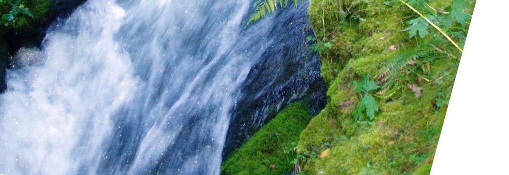
2 INTERIM REPORT LAKE CREEK ANADROMOUS BARRIER ANALYSIS SECTION 1: INTRODUCTION In accordance with the Cowlitz River Project settlement agreement of August 10, 2000, anadromous fish are being reintroduced into the upper Cowlitz River above Barrier, Mossyrock, and Cowlitz Falls dams via the trap-and-haul of adults. The target species under this agreement are Chinook and coho salmon and steelhead trout. Sea-run cutthroat trout are also transported and released above the dams (City of Tacoma 2000). With this reintroduction strategy, there is the potential for these species to utilize lower Lake Creek. Because there are no current data on species utilizing either lower Lake Creek or the tailrace slough, Energy Northwest requested that EES Consulting conduct electrofishing, snorkeling, and/or spawner surveys to verify the presence and relative abundance of anadromous salmonids as well as rainbow trout, cutthroat trout, lamprey, and sucker (EES Consulting, 2005). An integral part of the Lake Creek instream flow study is a physical habitat survey of Lake Creek in its entirety. A probable anadromous barrier (a 25 ft falls) exists at RM 1.95 and has been noted by the USDA Forest Service (1995) and Wieman (2004). Lucas (WDFW 1992) also identified this as the probable end of anadromous fish distribution and cited three independent surveys to support his conclusions including a WDFW foot survey, and surveys conducted by Bryant and Kray. EES Consulting noted a chute/falls complex that has the potential to be a barrier to upstream migration of anadromous fish at RM Energy Northwest, in consultation with EES Consulting, the tribes and natural resource agencies, discussed the feasibility of analyzing this chute against established, published criteria and evaluating its potential as an anadromous barrier. This report summarizes the results of that evaluation. Three anadromous fish species that would attempt to migrate upstream in Lake Creek are spring Chinook and coho salmon and steelhead trout. Chinook and coho salmon have been observed spawning below the chute/falls complex in 2004; steelhead trout have not been seen to date (latest survey July 12, 2005). SECTION 2: METHODS EES Consulting surveyed the falls/chute complex at RM 1.03 at three separate flows in Lake Creek flows are regulated by the Packwood Lake Hydroelectric Project plus additional accretion from tributaries downstream. Measurements were taken of the barrier at base, middle, and high calibration flows for the Lake Creek instream flow study. Page 1 July 2005
3 Cross sectional measurements were taken at lip (crest) of the falls/chute, in the middle section of the chute, and near the top of the chute. The longitudinal profile of the falls/chute complex was surveyed using a Topcon auto level and stadia rod and extended from the plunge pool at the base of the falls approximately 50 ft upstream of the lower end of the barrier. To define the profile, EES Consulting surveyed gradient breaks along the thalweg of the profile. Although measurements were not taken every foot, they adequately defined the longitudinal profile for purposes of this analysis. Detailed photographs and a video were taken of the falls/chute complex at flows of 46 cfs, 25 cfs and 11 cfs as measured at the downstream gage (releases of 33 cfs, 13 cfs and 3 cfs at the outlet structure, respectively). Velocities were taken at the falls crest, midchannel in the chute, and near the top of the chute. 2.1 Survey of Potential Barriers There are numerous boulder cascades, turbulent cascades, multiple falls and chutes present in Lake Creek below the intake structure. A total of 11 falls and 23 chutes were noted by the USDA Forest Service (1993) during its survey, and these were verified by EES Consulting in A chute/falls complex located at RM 1.03 has the potential to preclude upstream passage of anadromous salmonids. This chute was evaluated by EES Consulting for Energy Northwest. Upstream passage potential was analyzed for steelhead trout, the species with the greatest leaping ability among the anadromous fish present in the upper Cowlitz River system, as well as Chinook and coho salmon, which are known to utilize Lake Creek for spawning. The barrier was analyzed according to its height, horizontal distance, plunge pool exit conditions, crest depth and velocities, landing zone conditions and chute velocities ranging from flows of 3 cfs to 33 cfs as released from the project drop structure (i.e., flows at the barrier from approximately cfs). EES Consulting then used the criteria established in Powers and Orsborn (1985), including leaping ability, to assess passage, as agreed to in consultation with the agencies and tribes. Several factors are important to evaluate when determining passage success at barriers: 1) the plunge pool (fish entrance zone); 2) landing conditions (fish exit zone) and 3) the barrier itself (fish passage zone) (Powers and Orsborn 1985). White water and turbulence are also important to evaluate when assessing barriers. Jackson (1950) noted turbulence deflects a swimming fish from its course, causing it to expend energy resisting upwellings, eddies, entrapped air and vortices, which in turn make it impossible for a fish to use its swimming power effectively (Powers and Orsborn 1985). Factors influencing the fish entrance, passage and exit zones are summarized below and are derived from Powers and Orsborn (1985). Additional information was obtained from R2 Consultants and Ichthyological Associates, Inc (2000). Page 2 July 2005
4 Fish Entrance Zone A good takeoff pool is essential if fish are to leap effectively to any height. If the turbulent pool conditions, created from the falling water impacting the shallow pool, prevent a good takeoff, a relatively low fall my act as a total barrier (Powers and Orsborn 1985). In addition, air bubbles are created by the mixture of air and water as the falling water impacts the surface and entrain large quantities of air. When this occurs, the leaping height attained by fish attempting to leap the barrier is much less than the recorded maximum at other passable falls because of the reduced attraction flow (Stuart 1964). As stated in R2 Consultants and Ichthyological Associates, Inc (2000): A pool which is deep enough to absorb the falling water will result in the formation of a welldefined standing wave relatively close to the falls from which a fish can leap. A shallow plunge pool will result in highly turbulent conditions which produce difficult leaping conditions for fish. A shallow plunge pool will also result in the formation of the standing wave further downstream of the falls. This results in a greater leaping distance, since fish usually leap from the standing wave towards the barrier crest. In addition, the air bubbles created by the falls under these conditions greatly reduce the propulsive power of a fish s tail, resulting in smaller leaps (Stuart 1964). Aaserude (1984) concluded that two conditions should be satisfied to provide optimum leaping conditions in the plunge pools: 1. Depth of penetration of the falling water should be less than the depth of the plunge pool (turbulent pool conditions disorient fish and the standing wave is reduced and moved downstream). 2. Depth of the plunge pool must be greater than or equal to the length of the fish attempting to pass (if the depth less than length of fish, propulsive power of fish's tail may be reduced for leaping). Stuart (1964) also states that the depth of the plunge pool should be at least 1.25 times the falls height in order to create optimal leaping conditions for fish. Any waterfall that is steep enough to accelerate flow to violent white water should be considered a total barrier to upstream fish passage (Powers and Orsborn 1985). Fish Passage Zone Analysis of Falls One type of passage barrier is a falls. When the change in water surface elevation between pools exceeds the leaping height of the species in question, the falls is considered a barrier. For Pacific salmon and steelhead, the highest calculated leap from a level pool is 10.9 ft for steelhead. Falls where a change in water surface elevation is in excess of 11 ft can be considered a barrier (Powers and Orsborn 1985). Bruce Crawford (WDFW), however, observed steelhead jumping the Kalama Falls at the upper Kalama River Hatchery on a regular basis, with the occasional, younger (3 year old) Chinook salmon also jumping the falls. The falls is twelve feet in height on the upper Kalama Page 3 July 2005
5 River. It is his opinion that a jump of approximately 13 feet is closer to the true height that a steelhead can jump ( to H. Beecher, WDFW, February 25, 2005). In many cases, the actual distance the fish must leap is greater than the vertical drop between pools. Unless the water is falling vertically, some horizontal component of the leap will be required for successful passage. Assuming that the plunge pool and landing conditions are satisfied, the following conditions assess passage at waterfalls (from Table 8, Powers and Orsborn 1985): 1. If the change in water surface elevation > the height the fish can leap, it is an elevational barrier. 2. If the change in water surface elevation < the height the fish can leap, two analyses can be conducted: a. If the horizontal distance from the crest to the standing wave > horizontal leap at the highest point of the leap, it can either be passable or a horizontal distance barrier. b. If the horizontal distance from the crest to the standing wave < horizontal leap at the highest point of the leap, it is passable. Analysis of Chutes Another type of barrier is a chute. Powers and Orsborn (1985) states that by definition, the flow must be supercritical down the chute (Froude number is greater than unity). At the start of the chute the flow will pass through critical depth and then into a transition zone of varied flow for some distance before uniform flow is established. If the chute length is shorter than the transition length required to reach normal depth, uniform flow cannot be attained. The mean velocity of turbulent uniform flow in chutes can be expressed by the following equation: V = (1.49/n)(R) 0.67 (Sp) 0.5 where V = mean velocity (ft/sec), n = empirical roughness coefficient, R = hydraulic radius in ft and Sp = passage slope. The n value for smooth bedrock is ; the hydraulic radius was calculated by using the HYDSIM submodule of RHABSIM (by Thomas R. Payne and Associates), and the slope was calculated from the change in bed elevation and horizontal distance from the top to the bottom of the chute. The conditions for analyzing a chute are listed below and come directly from Powers and Orsborn (1985), assuming that plunge pool requirements, landing conditions and depth of flow are sufficient. Page 4 July 2005
6 Table 1. Chute conditions, given that plunge pool requirements, landing conditions, and depth of flow are sufficient (Powers and Orsborn 1985). Condition Result 1 If the Velocity of the water > Fish speed Velocity Barrier 2 The velocity of the water < fish speed Length of the slope > distance the fish can swim Length of the slope < distance the fish can swim Distance/velocity barrier Passable Classification of Barriers Powers and Orsborn (1985) assign a degree of passage difficulty rating (from 1 to 10, with 10 being the most difficult) that is independent of barrier height and velocity. The rating is based on the following assumptions: 1. The differential elevation and water velocities are within the swimming and leaping capabilities of the species in question. 2. At higher swimming speeds (> 9 ft/s) leaping is more energetically efficient than swimming (Blake 1983 as cited in Powers and Orsborn 1985). 3. Fish will be attracted to the area of highest momentum (flow x velocity) when migrating upstream; therefore, if multiple paths are present the fish may try to ascend the one with the highest attraction which will be created by the highest combination of drop, velocity, and discharge. [Note: This is not always the case, in that Dr. Beecher (WDFW) observed steelhead passage at the waterfall on the Little Klickitat River near the confluence of Bowman Creek during In this instance, he watched steelhead ascend a small chute to the side of the main waterfall that carried the bulk of the flow; here fish were able to move to a lateral area of reduced flow (H. Beecher letter to L. Vigue, WDFW, April 1, 2005)]. 4. Turbulent flow (for white water) with surges, boils, and eddies make it difficult for fish to orientate themselves and make full use of their swimming power. In the case of the barrier in question at RM 1.03, Powers and Orsborn (1985) would consider it a compound barrier, consisting of both a falls and a chute. Vertical Distance. According to Powers and Orsborn (1985), the curved trajectory of a fish leaping a falls can be best described as a projectile motion (see Figure 1, from Powers and Orsborn 1985). The leap can be divided into two components: vertical (y axis) and horizontal (x axis). Vertical distance represents the height a fish must leap in order to reach the top of the falls, and was calculated by subtracting the water surface elevation (WSE) of the plunge pool at each flow from the crest elevation of the barrier. The crest elevation is not always the highest elevation along the longitudinal profile, but the point which provided a resting area for the fish (R2 Consultants and Ichthyological Associates, Inc 2000). Page 5 July 2005
7 Horizontal Distance. The leap of a fish must be of sufficient length as to allow it to clear the horizontal distance between the plunge pool and the crest elevation. As stated by R2 Consultants and Ichthyological Associates, Inc (2000), This distance may be relatively short, such as at falls where water free-falls down to the plunge pool below. However, many bedrock waterfalls and most boulder cascades possess a steeply inclined face over which water flows at high velocities before striking the water. If the horizontal distance of a barrier is too long, then a falls which has a height which a fish can normally leap will still be a total barrier. EES Consulting determined the horizontal distance the fish was required to travel by subtracting the position of the base of the falls from the horizontal position of the crest with the resting area. Fish Landing Zone When fish leap at waterfalls, often the landing conditions near the crest are such that the fish may be swept back by high velocities or unable to propel themselves in water depths less than their body depths, where they are not totally submerged. The following factors should be evaluated when assessing landing conditions: 1. The depth of flow where the fish lands must be equal to or greater than the depth of the fish (generally considered to be 1.0 ft for steelhead). 2. The velocity where the fish lands should be within the range of the sustained swimming speed for the species in question. [Note: Dr. Beecher qualifies this statement: Leaping fish can often be swimming in air during a leap. They may land in a burst speed effort and so continue upstream through water that exceeds sustained swimming speed. Using the assumption that fish cannot exceed sustained swimming speed upon landing may lead to incorrect classification of a barrier (H. Beecher letter to L. Vigue, WDFW, April 1, 2005)]. 3. The velocity and depth should be analyzed under a range of fish migration flows (Powers and Orsborn 1985). 2.1 Fish Condition The ability of a fish to leap and swim is dependent upon its condition. Powers and Orsborn (1985) distinguish three different coefficient of fish condition (C fc ) based on the following definitions (Table 2): Table 2. Fish Condition (C fc ) (from Powers and Orsborn (1985). C fc Fish Condition 1.00 Bright: fresh out of salt water or still a long distance from spawning grounds; spawning colors not yet developed Good: in the river for a short time; spawning colors apparent but not fully developed; still migrating upstream Poor: in the river for a long time; full spawning colors developed and fully mature; very close to spawning grounds Page 6 July 2005
8 Figures 1 and 2 (Figures 7 and 8 in Powers and Orsborn 1985) show the leaping ability of steelhead trout and Chinook and coho salmon with C fc 1.00 and 0.75, respectively. Table 3 shows the leaping and swimming capabilities of steelhead trout in excellent, good (from R2 Consultants and Ichthyological Associates, Inc 2000) and poor conditions. Table 4 gives the leaping and swimming capabilities of Chinook and coho salmon (from Powers and Orsborn 1985). [Note: per agency consultation with P. Powers, WDFW, fish condition should no longer be considered a factor influencing the ability of a salmon or trout to negotiate a barrier, since the biological urge to spawn may override the physical condition of the fish. As a result, the tables and figures are retained with C fc values < 1.0 but are not used in the subsequent analysis]. Table 3. Leaping and swimming capabilities for steelhead trout in excellent (bright) condition. Leaping and performance values assume that no air is entrained in the water (sources: Powers and Orsborn 1985; Bell 1990). Table from R2 Consultants and Ichthyological Associates, Inc (2000). Description Maximum Height, 80 o Trajectory Maximum Horizontal Distance, 80 o Trajectory Maximum Height, 60 o Trajectory Maximum Horizontal Distance, 60 o Trajectory Maximum Height, 40 o Trajectory Maximum Horizontal Distance, 40 o Trajectory Maximum burst swimming speed Maximum prolonged swimming speed Maximum sustained swimming speed Maximum swimming distance, water velocity = 10 ft/sec Excellent Condition C fs = ft 8 ft 8.0 ft 19 ft 4.5 ft 22 ft 26.5 ft/s 13.7 ft/s 4.6 ft/s 83 ft Table 4. Leaping and swimming capabilities for Chinook and coho salmon in excellent (bright), Leaping and performance values assume that no air is entrained in the water (sources: Powers and Orsborn 1985; Bell 1990). Description Maximum Height, 80 o Trajectory Maximum Horizontal Distance, 80 o Trajectory Maximum Height, 60 o Trajectory Maximum Horizontal Distance, 60 o Trajectory Maximum Height, 40 o Trajectory Maximum Horizontal Distance, 40 o Trajectory Maximum burst swimming speed Maximum prolonged swimming speed Maximum sustained swimming speed Maximum swimming distance, water velocity = 10 ft/sec Excellent Condition C fs = ft 5 ft 5.8 ft 13 ft 3.2 ft 15 ft 22.4 ft/s 10.8 ft/s 3.4 ft/s 62 ft The burst speed of steelhead trout (26.5 ft/second) is given above for fish in excellent condition. It is important to note that the values of fish speeds suggested by Bell (1990) are for fish swimming in water without entrained air. When swimming in white water, Page 7 July 2005
9 the density of the water/air mixture will be reduced and detract from the propulsive power of the fish s tail, reducing its speed (Powers and Orsborn 1985). 3.1 Fish Condition SECTION 3: RESULTS AND DISCUSSION EES Consulting has observed many anadromous salmonids in both Lake Creek and the tailrace slough during 2004 (Chinook and coho salmon; see Lake Creek Spawner Survey report (EES Consulting, 2005) for details. All fish observed would have been classified as C fc 0.50 (poor) in that they already had been in the river a long time and trucked to the Skate Creek Bridge in Packwood; all were in spawning colors or had begun to fungus-up; with many of them physically deteriorating; and all were on or within a mile of the spawning grounds. Fish condition, per agency consultation with P. Powers of WDFW, should be excluded from the analysis. As a result, all species will be analyzed as if in excellent condition (C fc 1.00). 3.2 Description of Potential Barrier This potential barrier is classified as a compound falls and complex chute. The barrier is composed completely of bedrock. It has a total height (water surface elevation [WSE] of the plunge pool to WSE of the crest) of 9.32 ft as measured at the low flow release with an average gradient in the chute of over 41%. The upper half of this barrier is a very steep, narrow, twisting chute with measured velocities at the middle flow release of over 14 ft/s. The water is very shallow in the chute (< 0.4 ft), is fully entrained with air, and changes direction at the base, and there is a curved alignment of the chute (Appendix A Photo 3). There is no resting area in the chute, nor is there a place for fish to re-orient themselves before attempting to swim or leap the chute. At the flows observed, there is only one possible route through this compound barrier, although the chute has two flow streams. At higher flows, the hydraulics of the chute may change. Figure 3 shows the bed profile and various WSEs of this barrier. 3.2 Passage Analysis Photos of the chute at low, middle and high flows are included in Appendices A, B and C respectively. Plunge Pool Exit conditions for steelhead trout and Chinook and coho salmon can be considered good at all flows (see Photo 1 in each of the Appendices A, B and C). Although the surface of the plunge pool is highly turbulent, the depth of the pool is over 5 ft at the low flow and the depths increase with additional discharge (Table 5). Several smaller fish (approximately 12 in length) were observed attempting to jump into this falls, but were not successful. Page 8 July 2005
10 Table 5. Depth of plunge pool at measured flows Flow Depth (ft) Low 5.54 Middle 5.81 High 6.02 Vertical Distance Steelhead salmon with C fc 1.00 would be able to leap 10.8 ft at an 80 o angle (the angle with the highest leap; Powers and Orsborn 1985). Steelhead have been observed leaping 12 ft at Kalama Falls. Chinook and coho salmon leaping in excellent condition would be able to achieve a leap of 7.6 ft since the lip of the falls immediately above the plunge pool is only 4.3 ft. All species would be able to leap these falls. Although the lip of the falls immediately above the plunge pool is only 4.3 ft in elevation above the plunge pool WSE, there is no resting or landing zone available at the top of this falls. The water is fully entrained with air, reducing the propulsion effectiveness of the fish s tail, reducing the effective speed of the fish. As defined by Powers and Orsborn (1985), a good fish landing (i.e., exit) zone would have velocities where the fish lands within the sustained swimming speed of that species. Table 6 summarizes velocity measurements taken at the falls crest. The minimum velocity (at base flow) was 8.30 ft/s, which exceeds the sustained swimming speeds of steelhead trout and Chinook and coho salmon in excellent condition (4.6 ft/s and 3.4 ft/s, respectively), but not burst swimming speeds of 26.5 ft/s (steelhead) and 22.4 ft/s (Chinook and coho) for these species. Therefore, the total vertical distance to be leaped would need to be 9.32 feet to clear both the falls and the chute. This vertical distance exceeds the leaping capabilities of Chinook and coho salmon in excellent condition. Although steelhead trout in excellent condition have the ability to exceed the vertical component of the barrier, consideration must be given to the horizontal component. Horizontal Distance As mentioned above, the lip of the falls immediately above the plunge pool is only 4.3 ft above the plunge pool WSE; however, there is no resting or landing zone available at the top of this falls. Measured velocities (Table 6) exceed the sustained swimming speeds for steelhead trout and Chinook and coho salmon in excellent condition (as shown in Tables 3 and 4), but not the burst speed of either species. The water is fully entrained with air, reducing the propulsion effectiveness of the fish s tail and the effective capabilities of the fish. The only way for fish to make it past the falls and the chute would be to leap the horizontal distance from the plunge pool at the bottom of the barrier to the top of the barrier (explanation of chute characteristics are given below). This potential compound barrier consists of a falls and complex chute. Although the total length of this barrier is approximately 55 ft in length, the portion of interest extends from Page 9 July 2005
11 the base of the falls to the crest elevation immediately above the chute. This portion of the barrier is 26 ft long. This value exceeds the maximum horizontal leaping distance (assuming a 40 o leap) of 22 ft for steelhead trout in excellent condition and the maximum horizontal leaping distance for Chinook and coho salmon of 15 ft in excellent condition. Table 6. Velocities (ft/s) at the lip of the falls at measured flows. Flow Low 8.30 Mid Velocity (ft/s) High / 1/ Measurement not at same location do to safety concerns At the flows observed, the creek has stayed within the bedrock channel at the falls. Observations of higher flows have not yet occurred to determine if there is an alternative channel for fish migration (Figure 4). Chute Conditions Under all flow conditions that were evaluated, the upper half of this chute is steep and very narrow. Flow conditions in the chute ranged from measured velocities of 7.9 ft/s at low flow to ft/s at middle flow. Velocities were so high at the high flow that they could not be effectively measured. However, using Equation 1 in Powers and Orsborn (1985), velocities would approach 25.3 ft/s using a Manning s n of (Table 7). Table 7. Velocities (ft/s) in the main portion of the chute at measured flows. Flow Velocity (ft/s) Low 7.9 Mid High / 1/ Not measurable; Velocity calculated from Equation 1. As stated in Powers and Orsborn (1985), swimming speeds are predicated upon having depth of at least 1.0 feet for salmon and steelhead and there being no air entrained in the water. In this chute, water is approximately feet in depth and the water is completely entrained with air (see Appendix A, Photos 2 and 3; Appendix B, Photo 2; and Appendic C, Photos 2 and 3). The steepness of the chute as well as the high velocities can be observed in Appendix A, Photo 4; Appendix B, Photo 3, and Appendix C, Photo 4. This portion of the chute is significantly entrenched (Figure 5). Page 10 July 2005
12 None of the conditions required for fish to migrate this chute is present at this location. The depth of the water at the chute is less than 1.0 ft, so the fish s body is partially uncovered which reduces swimming effectiveness and the water is totally entrained with air (see Appendix C, Photo 2). Further, Powers and Orsborn (1985) state that any waterfall that is steep enough to accelerate flow to violent white water should be considered a total barrier to upstream fish passage. Because of these high chute velocities (> 9 ft/s), the fish would ascend this barrier by leaping (Powers and Orsborn 1985). However, there is no zone within the chute that would allow a fish to leap (depth of water inadequate; fully air-entrained water; turbulent white water associated with high velocities). The fish would need to leap from the plunge pool at the base of the falls to the crest elevation, a distance (26 ft) and height (9.3 ft) outside the leaping ability for all salmonids, including steelhead in excellent condition. Velocities measured at the main portion of the chute are less than steelhead burst speed at all flows evaluated; Chinook and coho salmon burst speeds are greater than the velocities measured at the low and middle flows, but are less than the velocities calculated at the highest flow measurement. Given the high velocities, fully air-entrained water, and depth, passage through the chute would be highly problematic. Crest Conditions The crest of this barrier is approximately 7.2 ft in width. Average crest velocities were somewhat lower than those velocities noted in the chute and ranged from 4.8 ft/s to 7.0 ft/s (Table 8). These velocities exceed the sustained swimming speeds of steelhead trout and Chinook and coho salmon in excellent condition while being less than the burst speed for these species. Depths were sufficient for passage at all flows noted (i.e., they exceeded the minimum depth of 1.0 ft required for upstream passage). Figure 7 shows the cross-sectional profile of the crest, which can also be viewed in Appendix A, Photo 4; Appendix B, Photo3; and Appendix C, Photo 4. Table 8. Velocities (ft/s) at the crest at measured flows. Flow Velocity (ft/s) Low 4.84 Mid 7.59 High / 1/ Measurement not at same location do to safety concerns SECTION 4: CONCLUSIONS Based upon the results of this analysis, the compound falls/chute barrier at RM 1.03 on Lake Creek may be considered an impassible barrier to upstream migration to anadromous fish at the range of flows examined. However, higher flows have not been evaluated at this location and ambiguities regarding the most applicable criteria cause uncertainty in this assessment. Energy Northwest has proposed a planned release from the drop structure in spring 2006 pending coordination with the power schedules and Page 11 July 2005
13 potential impacts to anadromous fish. This release flow cannot be fully controlled, however, a flow of approximately 100 cfs will be released if sufficient inflows enter Packwood Lake. Energy Northwest recommends that final resolution of the status of this potential barrier be deferred until an additional observation at the higher release flow can be made. In the interim, the criteria used to determine whether this is a potential barrier will be refined. Although anadromous spawner surveys conducted in 2004 and 2005 are not conclusive, the results are consistent with the surveys on Lake Creek conducted to date. Both Chinook and coho salmon have been observed migrating and spawning in Lake Creek. All spawning activity has been documented below RM 1.03, although several of the surveys have extended upstream to nearly the previously-acknowledged barrier at RM 1.95 (EES Consulting 2005). The area above RM 1.03 also lacks spawning substrates of proper size, with the first substantial suitable substrates noted approximately 100 yards below this location. A Chinook redd was found at the site of this gravel bar, and no spawning activity has been observed upstream of this site. Page 12 July 2005
14 Figure 1. Leaping curves for steelhead trout (From Powers and Orsborn 1985; Figure 7) Figure 2. Leaping curves for Chinook and coho salmon (From Powers and Orsborn 1985; Figure 8) Page 13 July 2005
15 Elevation (ft) Figure 3. Falls/Chute Complex Long. Profile at RM Chute Prof PP WSE Falls WSE Chute 1 WSE Crest WSE Chute 2 WSE Feet Figure 4. Mouth of Chute Profile Elevation (ft) Feet Bed Prof WSE Page 14 July 2005
16 Figure 5. Chute Cross Sectional Profile - Middle Section Elevation (ft) Feet Bed Prof WSE Figure 6. Chute - Top Profile Elevation (ft) Feet Bed Prof WSE Page 15 July 2005
17 SECTION 5: LITERATURE CITED Aaserude, R.G New concepts in fishway design. M.S. Thesis, Dept. Civil and Environmental Engineering, Washington State University. Beecher, H.A Letter to Ms. Lauri Vigue (WDFW) re: Packwood Lake Hydroelectric Project, FERC No. P Preliminary Draft Lake Creek Barrier Analysis April 1, Bell, M Fisheries handbook of engineering requirements and biological criteria. Fish Passage Development and Evaluation Program, Army Corps of Engineers. North Pacific Division, Portland, OR. Blake, R.W Fish locomotion. Cambridge University Press, Cambridge. Crawford, B to Dr. H. Beecher (WDFW) re: steelhead jumping. Feb. 25, EES Consulting Lake Creek Fisheries Investigations. Prepared for Energy Northwest by EES Consulting. July 2005 Energy Northwest Packwood Lake Hydroelectric Project, FERC No. 2244, Pre- Application Document, Supplement No. 1. December 6, Evans, W.W., and B. Johnston Fish migration and fish passage. USDA Forest Service, Washington, D.C. Rept. EM Jackson, R.I Variation in flow patterns at Hell s Gate and their relationships to the migration of sockeye salmon. Int. Pac. Salmon Fish. Comm. Bulletin III, Part II. Powers P.D., and J.F. Orsborn Analysis of barriers to upstream fish migration. Prepared for Bonneville Power Administration by Albrock Hydraulics Laboratory. Contract DE-A179-82B36523, Project No R2 Consultants and Ichthyological Associates, Inc Bypass reach (gorge) flow releases study report. Lake Chelan Hydroelectric Project (FERC No. 637), Prepared for Chelan County Public Utility District Stuart, T.A The leaping behaviour of salmon and trout at falls and obstructions. Dept. of Agriculture and Fisheries for Scotland, Edinburgh. 46p. USDA Forest Service R-6 stream survey level II. Lake Creek. Gifford Pinchot National Forest. Randle/Packwood Ranger Districts. USDA Forest Service As cited in Wieman (2004). Page 16 July 2005
18 Wieman, K Existing Information Analysis for Aquatic Biology Resources. USDA Forest Service Gifford Pinchot National Forest. 24 p. Washington Department of Fish and Wildlife (WDFW) Memo from Bob Lucas to Cowlitz Falls Advisory Group re: Upper Cowlitz Anadromous Zones. Washington Department of Fish and Wildlife. Vancouver, WA. Page 17 July 2005
19 APPENDIX A COMPOUND FALLS/CHUTE AT RM 1.03 LOW FLOW PHOTOS
20 Photo 1. Plunge pool and lip of falls at middle flow Photo 2. Chute at low flow. Appendix A, Page 1
21 Appendix A, Page 2 Photo 3. Mid chute complex, low flow.


22 Appendix A, Page 3 Photo 4. Top of chute, low flow.
23 APPENDIX B COMPOUND FALLS/CHUTE AT RM 1.03 MIDDLE FLOW PHOTOS
24 Photo 1. Plunge pool and lip of falls at middle flow Photo 2. Mid chute at middle flow Appendix B, Page 1
25 Appendix B, Page 2 Photo 3. Top of chute at middle flow
26 APPENDIX C COMPOUND FALLS/CHUTE AT RM 1.03 HIGH FLOW PHOTOS


27 Photo 1. Plunge pool and lip of falls at high flow Photo 2. Lower part of chute, high flow Appendix C, Page 1


28 Photo 3. Chute at high flow Photo 4. Top of chute at high flow Appendix C, Page 2
Packwood Hydroelectric Project Barrier Analysis December 12, 2006
 Packwood Hydroelectric Project Barrier Analysis December 12, 2006 Study Area Natural barriers to upstream fish passage on Lake Creek at RM 1.03 and RM 1.95 Snyder Creek culvert under the Project tailrace
Study Update Fish Distribution and Species Composition
 Study Update Fish Distribution and Species Composition Goals and Study Area Gain a better understanding of fish species composition and abundance in waters associated with the Packwood Lake Hydroelectric
Packwood Lake Intake Screen Velocity Test Report for Energy Northwest's Packwood Lake Hydroelectric Project FERC No Lewis County, Washington
 for Energy Northwest's Packwood Lake Hydroelectric Project FERC No. 2244 Lewis County, Washington Submitted to P.O. Box 968 Richland, Washington 99352-0968 Submitted by EES Consulting 1155 North State
Study Update Tailrace Slough Use by Anadromous Salmonids
 Study Update Tailrace Slough Use by Anadromous Salmonids Goals and Objectives Identify what anadromous salmonids use the tailrace slough by: Life Stage (Juvenile, migrating and spawning adults) Timing
BATTLE CREEK FISHERIES STUDIES TASK 4: SURVEYS OF BARRIERS TO THE UPSTREAM MIGRATION OF ANADROMOUS SALMONIDS
 BATTLE CREEK FISHERIES STUDIES TASK 4: SURVEYS OF BARRIERS TO THE UPSTREAM MIGRATION OF ANADROMOUS SALMONIDS Prepared for: California Department of Fish and Game Redding, California 96001 Prepared by:
Packwood Lake Hydroelectric Project (FERC No. P-2244) Anadromous Salmonid Habitat and Spawner Survey Report
 Anadromous Salmonid Habitat and Spawner Survey Report") Packwood Lake Hydroelectric Project (FERC No. P-2244) Anadromous Salmonid Habitat and Spawner Survey Report Prepared For Prepared By EES Consulting 1155 N. State Street, Suite 700 Bellingham, WA 98225
Packwood Lake Hydroelectric Project (FERC No. P-2244) Anadromous Salmonid Habitat and Spawner Survey Report Prepared For Prepared By EES Consulting 1155 N. State Street, Suite 700 Bellingham, WA 98225
Five Counties Salmonid Conservation Program - Fish Passage Design Workshop. February 2013
 Program - Aquatic Organisms and Stream Crossings Ecological Connectivity A watershed is a network of channels that drain a common boundary. Channel characteristics formed by interaction of precipitation,
Final Bull Trout Genetics Monitoring Plan for the Wallowa Falls Hydroelectric Project. (FERC No. P-308) June 2017
 June 2017") Final for the Wallowa Falls Hydroelectric Project (FERC No. P-308) June 2017 Prepared by: Jeremiah Doyle PacifiCorp 825 NE Multnomah Street Portland, OR 97232 June, 2017 Page 1 of 8 Table of Contents 1.0
Final for the Wallowa Falls Hydroelectric Project (FERC No. P-308) June 2017 Prepared by: Jeremiah Doyle PacifiCorp 825 NE Multnomah Street Portland, OR 97232 June, 2017 Page 1 of 8 Table of Contents 1.0
4.4 ASSESSMENT OF POTENTIAL ANADROMOUS FISH HABITAT UPSTREAM OF MERWIN DAM (AQU 4)
") 4.4 ASSESSMENT OF POTENTIAL ANADROMOUS FISH HABITAT UPSTREAM OF MERWIN DAM (AQU 4) 4.4.1 Study Objectives The objectives of this study are to: (1) delineate the stream segments in the upper North Fork
4.4 ASSESSMENT OF POTENTIAL ANADROMOUS FISH HABITAT UPSTREAM OF MERWIN DAM (AQU 4) 4.4.1 Study Objectives The objectives of this study are to: (1) delineate the stream segments in the upper North Fork
Summary of the Pilot Assessment of Three Potential Fish Barriers on Battle Creek
 Summary of the Pilot Assessment of Three Potential Fish Barriers on Battle Creek Laurie A. Earley March 2014 U.S. Fish and Wildlife Service, Red Bluff Fish and Wildlife Office 10950 Tyler Road, Red Bluff,
Steve Hemstrom Sr. Fisheries Biologist Chelan PUD Natural Resources Desk: Cell:
 From: To: Cc: Subject: Date: Attachments: Hemstrom, Steven "Lewis, Stephen" Sokolowski, Rosana 2014 Rocky Reach Bull Trout Report Wednesday, June 18, 2014 3:01:07 PM Final 2014 Rocky Reach Bull Trout Observations
FSOC Upstream Fish Passage Guidance Document
 FSOC Upstream Fish Passage Guidance Document STEP 1: Identify species and life stages in need of fish passage STEP 2: Identify fishway options and species applicability STEP 3 Fish passage criteria review
Interim Guidance Fish Presence Absence
 Interim Guidance Fish Presence Absence Source: Forest Practices Act Guidance for Division 635 of the forest practices act dealing with stream classification when no fish surveys have been done (referenced
Job 1. Title: Estimate abundance of juvenile trout and salmon.
 STUDY PERFORMANCE REPORT State: Michigan Project No.: F-53-R-13 Study No.: 461 Title: Population dynamics of juvenile rainbow trout and coho salmon in Lake Superior tributaries Period Covered: April 1,
Big Spring Creek Habitat Enhancement and Fishery Management Plans
 Big Spring Creek Habitat Enhancement and Fishery Management Plans November 5, 2012 Big Spring Events and Activities Center Newville, PA Charlie McGarrell Regional Habitat Biologist Pennsylvania Fish and
Redd Dewatering and Juvenile Salmonid Stranding in the Lower Feather River,
 Redd Dewatering and Juvenile Salmonid Stranding in the Lower Feather River, 2005-2006 Interim Report for NOAA Fisheries Prepared by: California Department of Water Resources Division of Environmental Services
FISH PASSAGE IMPROVEMENT in California s Watersheds. Assessments & Recommendations by the Fish Passage Forum
 FISH PASSAGE IMPROVEMENT in California s Watersheds Assessments & Recommendations by the Fish Passage Forum FISH PASSAGE IMPROVEMENT in California s Watersheds The mission of the Fish Passage Forum is
THE CONFEDERATED TRIBES OF THE WARM SPRINGS RESERVATION OF OREGON
 THE CONFEDERATED TRIBES OF THE WARM SPRINGS RESERVATION OF OREGON To: Branch of Natural Resources P.0. Box C, Warm Springs, Oregon 97761 Phone (541) 553-2002/2003 Fax (541) 553-1994 The Independent Science
Evaluation of Salmon and Steelhead Migration Through the Upper Sultan River Canyon Prior to Dam Construction
 Evaluation of Salmon and Steelhead Migration Through the Upper Sultan River Canyon Prior to Dam Construction Prepared for City of Everett July 2006 Cover photographs (clockwise): Cascade 6, upper Cascade
Newaukum Watershed Culvert Assessment
 Newaukum Watershed Culvert Assessment Water Resource Inventory Area 23 Lewis County Conservation District Final Report By: Kelly Verd and Nikki Wilson July 2002 Funded by: Chehalis Fisheries Restoration
Final Bull Trout Redd Monitoring Report for the Wallowa Falls Hydroelectric Project
 Final for the Wallowa Falls Hydroelectric Project East Fork Wallowa River barrier to upstream fish migration, photo courtesy of Kendrick Moholt (FERC No. P-308) December 18, 2017 Prepared by: Jeremiah
Session C9: Priest Rapids Fish Bypass: A Case Study from Start to Finish
 University of Massachusetts - Amherst ScholarWorks@UMass Amherst International Conference on Engineering and Ecohydrology for Fish Passage International Conference on Engineering and Ecohydrology for Fish
Advanced Hydraulics Prof. Dr. Suresh A. Kartha Department of Civil Engineering Indian Institute of Technology, Guwahati
 Advanced Hydraulics Prof. Dr. Suresh A. Kartha Department of Civil Engineering Indian Institute of Technology, Guwahati Module - 4 Hydraulics Jumps Lecture - 4 Features of Hydraulic Jumps (Refer Slide
APPENDIX B. Final reports on chinook salmon spawning surveys - Sultan River, Washington Report
 APPENDX B Final reports on chinook salmon spawning surveys - Sultan River, Washington B-1. B-2. 1987 Report. 1988 Report APPENDX B-l Final report on 1987 chinook spawning survey - Sultan River, Snohomish
REVISED DRAFT HABITAT SUITABILITY CURVES and COHO SALMON and STEELHEAD TROUT. Sawmill Creek Alaska
 REVISED DRAFT HABITAT SUITABILITY CURVES and COHO SALMON and STEELHEAD TROUT Sawmill Creek Alaska Blue Lake Hydroelectric Project, FERC No. 2230, Relicensing Prepared by: City and Borough of Sitka ( City
STEELHEAD SURVEYS IN OMAK CREEK
 STEELHEAD SURVEYS IN OMAK CREEK 2002 Annual Report Prepared by Chris Fisher John Arterburn Colville Confederated Tribes Fish and Wildlife Department P.O. Box 150 Nespelem, WA 99155 Prepared for Project
August 11 Snorkel SCC side channel network (SBA, SCC3) feet 707
 feet 707") Date Survey Type Habitat July 29 Snorkel (reconnaissance) Table 1. Fish use survey schedule 2004 Water temperature 1 (ºC) Estimated Mean visibility 2 discharge 3 (cfs) Mainstem (units #1 42) ND ND 814
Date Survey Type Habitat July 29 Snorkel (reconnaissance) Table 1. Fish use survey schedule 2004 Water temperature 1 (ºC) Estimated Mean visibility 2 discharge 3 (cfs) Mainstem (units #1 42) ND ND 814
Proposed Habitat Suitability Criteria (HSC) Curves For Application in Habitat Flow Modeling For the Sultan River Instream Flow Study RSP 3
 Curves For Application in Habitat Flow Modeling For the Sultan River Instream Flow Study RSP 3") - - Proposed Habitat Suitability Criteria (HSC) Curves For Application in Habitat Flow Modeling For the Sultan River Instream Flow Study RSP 3 Prepared for: Public Utility District No. 1 of Snohomish County
- - Proposed Habitat Suitability Criteria (HSC) Curves For Application in Habitat Flow Modeling For the Sultan River Instream Flow Study RSP 3 Prepared for: Public Utility District No. 1 of Snohomish County
Fish Distribution and Species Composition Study Plan for Energy Northwest's Packwood Lake Hydroelectric Project FERC No Lewis County, Washington
 Revised Fish Distribution and Species Composition Study Plan for Energy Northwest's Packwood Lake Hydroelectric Project FERC No. 2244 Lewis County, Washington Submitted to P.O. Box 968 Richland, Washington
Aquatic Organism Passage at Road-Stream Crossings CHUCK KEEPORTS FOREST HYDROLOGIST ALLEGHENY NATIONAL FOREST WARREN, PENNSYLVANIA
 Aquatic Organism Passage at Road-Stream Crossings CHUCK KEEPORTS FOREST HYDROLOGIST ALLEGHENY NATIONAL FOREST WARREN, PENNSYLVANIA TOPICS COVERED Aquatic Organism Passage (AOP) Benefits of AOP Crossings
Susitna-Watana Hydroelectric Project (FERC No )
") (FERC No. 14241) Study of Fish Passage Barriers in the Middle and Upper Susitna River and Susitna Tributaries Study Plan Section 9.12 Final Study Plan July 2013 9.12. Study of Fish Passage Barriers in
(FERC No. 14241) Study of Fish Passage Barriers in the Middle and Upper Susitna River and Susitna Tributaries Study Plan Section 9.12 Final Study Plan July 2013 9.12. Study of Fish Passage Barriers in
SUBMERGED VENTURI FLUME. Tom Gill 1 Robert Einhellig 2 ABSTRACT
 SUBMERGED VENTURI FLUME Tom Gill 1 Robert Einhellig 2 ABSTRACT Improvement in canal operating efficiency begins with establishing the ability to measure flow at key points in the delivery system. The lack
A THESIS M.S. CIVIL ENGINEERING UNIVERSITY OF ALASKA ANCHORAGE ALEXANDRA WEST JEFFERIES, P.E.
 Assessing Fish Passage Success in Culvert Structures with the Development of a Two-Dimensional Algorithm Considering Physical Capabilities of Juvenile Salmonids ALEXANDRA WEST JEFFERIES, P.E. A THESIS
Chinook Salmon Spawning Study Russian River Fall 2005
 Chinook Salmon Spawning Study Russian River Fall 2005 Sonoma County Water Agency 2150 West College Avenue Santa Rosa, California 95401 Prepared by David Cook - Senior Environmental Specialist March 27,
Plate 21: Vertical slot fishway retrofitted to a small power plant.
 34 Vertical slot fishways The basic design of a vertical slot fishway is a rectangular channel partitioned by baffles into resting pools. When the water is flowing the fish swim from pool to pool through
Monitoring of Downstream Fish Passage at Cougar Dam in the South Fork McKenzie River, Oregon February 8, By Greg A.
 Monitoring of Downstream Fish Passage at Cougar Dam in the South Fork McKenzie River, Oregon 1998- February 8, 2 By Greg A. Taylor Oregon Dept. of Fish & Wildlife 315 E. Main Street Springfield, OR 97478
An Investigation of the Hydraulics in a Prototype Pool-and-Chute, Vortex Weir Fishway for Anadromous Fish Passage
 University of Massachusetts Amherst ScholarWorks@UMass Amherst International Conference on Engineering and Ecohydrology for Fish Passage International Conference on Engineering and Ecohydrology for Fish
Southern Oregon Coastal Cutthroat Trout
 Species Management Unit Description Southern Oregon Coastal Cutthroat Trout The Southern Oregon Coastal Cutthroat Trout SMU includes all populations of cutthroat trout inhabiting ocean tributary streams
Defining Flow Windows for Upstream Passage of Adult Anadromous Salmonids at Cascades and Falls
 Transactions of the American Fisheries Society 135:668 679, 2006 Ó Copyright by the American Fisheries Society 2006 DOI: 10.1577/T05-169.1 [Article] Defining Flow Windows for Upstream Passage of Adult
Wenatchee Spring Chinook Relative Reproductive Success Study. Andrew Murdoch (WDFW) Michael Ford (NOAA) Michael Hughes (WDFW)
 Michael Ford (NOAA) Michael Hughes (WDFW)") Wenatchee Spring Chinook Relative Reproductive Success Study Andrew Murdoch (WDFW) Michael Ford (NOAA) Michael Hughes (WDFW) Acknowledgements Bonneville Power Administration Chelan PUD Grant PUD Study
Wenatchee Spring Chinook Relative Reproductive Success Study Andrew Murdoch (WDFW) Michael Ford (NOAA) Michael Hughes (WDFW) Acknowledgements Bonneville Power Administration Chelan PUD Grant PUD Study
Lewis River Hydroelectric Projects Settlement Agreement Aquatic Coordination Committee (ACC) Meeting Agenda
 Meeting Agenda") Lewis River Hydroelectric Projects Settlement Agreement Aquatic Coordination Committee (ACC) Meeting Agenda Date & Time: Thursday, September 4, 27 9: a.m. : a.m. Place: CONFERENCE CALL ONLY Contacts: Frank
Lewis River Hydroelectric Projects Settlement Agreement Aquatic Coordination Committee (ACC) Meeting Agenda Date & Time: Thursday, September 4, 27 9: a.m. : a.m. Place: CONFERENCE CALL ONLY Contacts: Frank
Subject: Developed fish ladder alternatives for Pastori Avenue at San Anselmo Creek
 Page 1 of 18 SENT VIA EMAIL Sandra Guldman Friends of Corte Madera Creek Watershed Box 415 Larkspur, CA 94977 Subject: Developed fish ladder alternatives for Pastori Avenue at San Anselmo Creek Dear Sandra,
BC Ministry of Forests. March Fish Stream Crossing Guidebook. Forest Practices Code of British Columbia.
 FRST 557 Lecture 7c Bridges and Culverts: Water Velocity and Discharge Lesson Background and Overview: The previous two lessons presented methods for estimating water volume flow at a particular site and
2 nd Steelhead Summit. October 27 & 28, 2016 in San Luis Obispo, CA
 + 2 nd Steelhead Summit October 27 & 28, 2016 in San Luis Obispo, CA 1 + Session Overview Sponsors: California Trout City of San Luis Obispo Sustainable Conservation California Conservation Corps Cachuma
Components of a Barrage
 Components of a Barrage Definition The only difference between a weir and a barrage is of gates, that is the flow in barrage is regulated by gates and that in weirs, by its crest height. Barrages are costlier
Attachment 6. Public Correspondence. Public correspondence received as of July 2, 2008
 Attachment 6 Public Correspondence Public correspondence received as of July 2, 2008 May 8, 2008 Roger Smith Oregon Department of Fish and Wildlife 3406 Cherry Avenue N.E. Salem, OR 97303 Mr. Smith and
SELBY CREEK SILVERADO TRAIL CULVERT FISH PASSAGE ASSESSMENT
 SELBY CREEK SILVERADO TRAIL CULVERT FISH PASSAGE ASSESSMENT NAPA COUNTY, CALIFORNIA PREPARED BY NAPA COUNTY RESOURCE CONSERVATION DISTRICT 1303 JEFFERSON ST. SUITE 500B NAPA, CALIFORNIA 94559 WWW.NAPARCD.ORG
PRE- PROPOSAL FORM - Lewis River Aquatic Fund
 PRE- PROPOSAL FORM - Lewis River Aquatic Fund 1. Applicant organization. USDA Forest Service Gifford Pinchot National Forest 2. Organization purpose Resource management agency 3. Project manager (name,
South Fork Chehalis Watershed Culvert Assessment
 South Fork Chehalis Watershed Culvert Assessment Water Resource Inventory Area 23 Lewis County Conservation District Final Report By: Kelly Verd and Nikki Wilson March 2003 Funded by: The Washington State
Union Pacific Railroad
 Input Questions: 404/401 Pre Application Meeting, December 18, 2013, Portland, Oregon 1. What is the project purpose and need? The purpose of the project is to improve the efficiency and average velocity
Fish Passage Assessment of Private Stream Crossings on Lower Stonybrook Creek
 Fish Passage Assessment of Private Stream Crossings on Lower Stonybrook Creek Prepared by: Michael Love & Associates In cooperation with: Center for Ecosystem Management and Restoration Funded by: Coastal
Project Award Presentation
 University of Massachusetts Amherst ScholarWorks@UMass Amherst International Conference on Engineering and Ecohydrology for Fish Passage International Conference on Engineering and Ecohydrology for Fish
Ermenek Dam and HEPP: Spillway Test & 3D Numeric-Hydraulic Analysis of Jet Collision
 Ermenek Dam and HEPP: Spillway Test & 3D Numeric-Hydraulic Analysis of Jet Collision J.Linortner & R.Faber Pöyry Energy GmbH, Turkey-Austria E.Üzücek & T.Dinçergök General Directorate of State Hydraulic
Strategies for mitigating ecological effects of hatchery programs
 Strategies for mitigating ecological effects of hatchery programs Some case studies from the Pacific Northwest Kathryn Kostow Oregon Department of Fish and Wildlife Ecological risks occur when the presence
Plan B Dam Breach Assessment
 Plan B Dam Breach Assessment Introduction In support of the Local Sponsor permit applications to the states of Minnesota and North Dakota, a dam breach analysis for the Plan B alignment of the Fargo-Moorhead
Preliminary survival estimates for the passage of spring-migrating juvenile salmonids through Snake and Columbia River dams and reservoirs, 2016
 UNITED STATES DEPARTMENT OF COMMERCE National Oceanic and Atmospheric Administration NATIONAL MARINE FISHERIES SERVICE Northwest Fisheries Science Center Fish Ecology Division 2725 Montlake Boulevard East
Rock Ramp Design Guidelines. David Mooney MS Chris Holmquist-Johnson MS Drew Baird Ph.D. P.E. Kent Collins P.E.
 Rock Ramp Design Guidelines David Mooney MS Chris Holmquist-Johnson MS Drew Baird Ph.D. P.E. Kent Collins P.E. Rock Ramp Design Guidelines OUTLINE Local and System Interactions with Rock Ramps Ramp Geometry
Rhode Island Department of Environmental Management Division of Fish and Wildlife American Shad Habitat Plan for the Pawcatuck River
 Rhode Island Department of Environmental Management Division of Fish and Wildlife American Shad Habitat Plan for the Pawcatuck River Prepared by: Phil Edwards, Rhode Island Department of Environmental
SALMON FACTS. Chinook Salmon. Oncorhynchus tshawytscha
 SALMON FACTS Chinook Salmon Oncorhynchus tshawytscha Other names: king, tyee, blackmouth (immature) Average size: 10-15 lbs, up to 135 lbs Fall spawner; fall, spring, and summer runs Chinook salmon are
REC 6 FISHERIES HABITAT EVALUATION
 REC 6 FISHERIES HABITAT EVALUATION 1.0 EXECUTIVE SUMMARY Analysis of fisheries habitat for recreational angling opportunities was completed by reviewing the results of the CAWG 1, Characterize Stream and
Assessment of Baseline Geomorphic Features at. Proposed Stream Crossings On The Proposed County Road 595. Marquette County, Michigan
 Assessment of Baseline Geomorphic Features at Proposed Stream Crossings On The Proposed County Road 595 Marquette County, Michigan Prepared for: Kennecott Eagle Minerals Company Marquette, Michigan Prepared
145 FERC 62,070 UNITED STATES OF AMERICA FEDERAL ENERGY REGULATORY COMMISSION
 145 FERC 62,070 UNITED STATES OF AMERICA FEDERAL ENERGY REGULATORY COMMISSION Public Utility District No. 1 of Douglas County, Washington Project No. 2149-163 ORDER APPROVING BULL TROUT STRANDING, ENTRAPMENT,
DESCRIPTION OF THE CHELAN RIVER
 DESCRIPTION OF THE CHELAN RIVER The following information contains excerpts from the Whitewater Boating Feasibility Study conducted on the Chelan River in July, 2000. The Chelan River begins below the
OREGON DEPARTMENT OF FISH AND WILDLIFE ROGUE FISH DISTRICT REPORT
 OREGON DEPARTMENT OF FISH AND WILDLIFE ROGUE FISH DISTRICT REPORT TITLE: Upper Rogue Smolt Trapping Project, 1999 STREAM: Big Butte, Little Butte, South Fork Big Butte, Slate and West Fork Evans Creeks
Juvenile Steelhead and Stream Habitat Conditions Steelhead and Coho Salmon Life History Prepared by: DW ALLEY & Associates, Fishery Consultant
 Juvenile Steelhead and Stream Habitat Conditions Steelhead and Coho Salmon Life History Prepared by: DW ALLEY & Associates, Fishery Consultant I-1. Steelhead and Coho Salmon Ecology Migration. Adult steelhead
OREGON AND WASHINGTON DEPARTMENTS OF FISH AND WILDLIFE JOINT STAFF REPORT - WINTER FACT SHEET NO.
 OREGON AND WASHINGTON DEPARTMENTS OF FISH AND WILDLIFE JOINT STAFF REPORT - WINTER FACT SHEET NO. 3a Columbia River Compact/Joint State Hearing February 21, 2018 Fisheries under consideration: Mainstem
Washington State Fish Passage Barrier Removal Projects. Casey Kramer, PE WSDOT State Hydraulics Engineer
 Washington State Fish Passage Barrier Removal Projects Casey Kramer, PE WSDOT State Hydraulics Engineer 2014 National Hydraulic Engineering Conference Iowa City, IA August 20 th, 2014 WSDOT Fish Passage
PRE- PROPOSAL FORM - 1. Applicant organization. USDA Forest Service Gifford Pinchot National Forest & WDFW Region 5
 PRE- PROPOSAL FORM - 1. Applicant organization. USDA Forest Service Gifford Pinchot National Forest & WDFW Region 5 2. Organization purpose USFS-Resource management agency WDFW-Fish and Wildlife management
CUSHMAN RESERVOIRS. Skokomish Watershed Monitoring Conference - Public Meeting Florian Leischner 9/17/2015
 CUSHMAN RESERVOIRS Skokomish Watershed Monitoring Conference - Public Meeting Florian Leischner 9/17/2015 CUSHMAN RESERVOIRS MONITORING Management and monitoring of Tacoma Power reservoirs Lake Cushman
MINISTRY OF ENVIRONMENT ENVIRONMENTAL STEWARDSHIP DIVISION FISH AND WILDLIFE BRANCH. Horsefly River Angling Management Plan
 MINISTRY OF ENVIRONMENT ENVIRONMENTAL STEWARDSHIP DIVISION FISH AND WILDLIFE BRANCH Horsefly River Angling Management Plan January 30 th, 2006 Area/Fishery Description The Horsefly River watershed provides
3. The qualification raised by the ISRP is addressed in #2 above and in the work area submittal and review by the ISRP as addressed in #1.
 Please find attached a response from The Confederated Tribes of the Warm Springs Reservation of Oregon (CTWSRO) for Project # 2008-301-00, Habitat Restoration Planning, Design and Implementation within
Okanagan Sockeye Reintroduction
 Okanagan Sockeye Reintroduction Backgrounder Elders accounts, and other forms of Traditional Ecological Knowledge (TEK) tell us that many species of salmon once came into the Okanagan Valley and tell us
BULL TROUT OPERATIONAL PLAN
 BULL TROUT OPERATIONAL PLAN ROCKY REACH HYDROELECTRIC PROJECT FERC Project No. 2145 April 10, 2001 Public Utility District No. 1 of Chelan County Wenatchee, Washington BULL TROUT OPERATIONAL PLAN This
FINAL Caples Lake Fisheries Management Plan. Version 4.0
 FINAL Caples Lake Fisheries Management Plan Version 4.0 August 15, 2008 Purpose The Caples Lake Fisheries Management Plan (Plan) outlines the stocking plan to reestablish a sport fishery in Caples Lake
Abundance of Steelhead and Coho Salmon in the Lagunitas Creek Drainage, Marin County, California
 scanned for KRIS Abundance of Steelhead and Coho Salmon in the Lagunitas Creek Drainage, Marin County, California Prepared for: Marin Municipal Water District 220 Nellen Drive Corte Madera, California
Advanced Hydraulics Prof. Dr. Suresh A. Kartha Department of Civil Engineering Indian Institute of Technology, Guwahati
 Advanced Hydraulics Prof. Dr. Suresh A. Kartha Department of Civil Engineering Indian Institute of Technology, Guwahati Module - 4 Hydraulic Jumps Lecture - 1 Rapidly Varied Flow- Introduction Welcome
EXAMPLES (OPEN-CHANNEL FLOW) AUTUMN 2018
 AUTUMN 2018") EXAMPLES (OPEN-CHANNEL FLOW) AUTUMN 2018 Normal and Critical Depths Q1. If the discharge in a channel of width 5 m is 20 m 3 s 1 and Manning s n is 0.02 m 1/3 s, find: (a) the normal depth and Froude number
EXAMPLES (OPEN-CHANNEL FLOW) AUTUMN 2018 Normal and Critical Depths Q1. If the discharge in a channel of width 5 m is 20 m 3 s 1 and Manning s n is 0.02 m 1/3 s, find: (a) the normal depth and Froude number
Data Report : Russian River Basin Steelhead and Coho Salmon Monitoring Program Pilot Study
 Data Report 1999-1: Russian River Basin Steelhead and Coho Salmon Monitoring Program Pilot Study Sonoma County Water Agency 215 West College Avenue Santa Rosa, California 951 Prepared by David Cook Senior
Columbia Lake Dam Removal Project
 Columbia Lake Dam Removal Project The Columbia Lake dam located 1/4 mile upstream of the Paulins Kill River's confluence with the Delaware River in Knowlton Township, Warren County has been proposed for
Applying Engineering Solutions to the Science of Invasive Aquatic Species Control Asian Carp and Sea Lamprey. Bill Holman, P.E. Stanley Consultants
 Applying Engineering Solutions to the Science of Invasive Aquatic Species Control Asian Carp and Sea Lamprey Bill Holman, P.E. Stanley Consultants Sea Lamprey: Great Lakes Invader Lake Superior Sea Lamprey
Fish Habitat Restoration and Monitoring in Southeast Washington. Andy Hill Eco Logical Research, Inc.
 Fish Habitat Restoration and Monitoring in Southeast Washington Andy Hill Eco Logical Research, Inc. Fish Habitat Restoration and Monitoring in Southeast Washington Talk overview: Restoration projects
Chadbourne Dam Repair and Fish Barrier
 Chadbourne Dam Repair and Fish Barrier Final Report for the Western Native Trout Initiative Prepared by: Carol Endicott Yellowstone Cutthroat Trout Conservation Biologist Montana Fish, Wildlife & Parks
APPENDIX D: LEWIS RIVER HATCHERY REVIEW
 APPENDIX D: LEWIS RIVER HATCHERY REVIEW JANUARY 14, 2004 Prepared for PacifiCorp and Cowlitz PUD Prepared by S.P. Cramer & Associates, Inc. 600 NW Fariss Gresham, Oregon 97030 www.spcramer.com D-1 TABLE
Sub-watershed Summaries
 Project Description The Salmon Drift Creek Watershed Council (SDCWC) has focused their efforts in the Salmon River estuary for the past few years. The multifaceted partnership effort is nearing completion
Youngs Creek Hydroelectric Project (FERC No. P 10359)
") Youngs Creek Hydroelectric Project (FERC No. P 10359) Resident Trout Monitoring Plan Annual Report 2010 Survey and Results of Pre Project Monitoring Prepared by: September 2010 Overview The Public Utility
Youngs Creek Hydroelectric Project (FERC No. P 10359) Resident Trout Monitoring Plan Annual Report 2010 Survey and Results of Pre Project Monitoring Prepared by: September 2010 Overview The Public Utility
Greenup Lock Filling and Emptying System Study
 Fourth LACCEI International Latin American and Caribbean Conference for Engineering and Technology (LACCET 2006) Breaking Frontiers and Barriers in Engineering: Education, Research and Practice 21-23 June
Discussion on the Selection of the Recommended Fish Passage Design Discharge
 Discussion on the Selection of the Recommended Fish Passage Design Discharge Introduction The provision of fish passage is a requirement for most proposed culvert and bridge installations in Alberta, depending
Upstream Passage Assessment of American Shad Using 3D Acoustic Telemetry
 Upstream Passage Assessment of American Shad Using 3D Acoustic Telemetry Timothy Hogan, Alden Research Laboratory Corey Wright, Blue Leaf Environmental Skip Medford, Enel Green Power North America Abstract
MEMORANDUM. Joan Dukes, NPCC. Michele DeHart. DATE: August 5, Data Request
 FISH PASSAGE CENTER 1827 NE 44 th Ave., Suite 240, Portland, OR 97213 Phone: (503) 230-4099 Fax: (503) 230-7559 http://www.fpc.org/ e-mail us at fpcstaff@fpc.org MEMORANDUM TO: Joan Dukes, NPCC FROM: Michele
Lake Chelan Kokanee Spawning Ground Surveys 2012 Final Report
 Lake Chelan Kokanee Spawning Ground Surveys 2012 Final Report Spawning kokanee (Oncorhynchus nerka) in Company Creek Chelan County PUD, 2005. (Photo by Brad Buchsieb) Prepared by: Barry G. Keesee And Lance
Fish Passage Design Aids Wildlife Crossing in Washington State State of the Practice
 Fish Passage Design Aids Wildlife Crossing in Washington State State of the Practice 0 Submission date: November, 0 Word Count:, Jon Peterson, corresponding author (0-0-, peterjn@wsdot.wa.gov) Fish Passage
Date: 25 September Introduction
 To: David Clugston, USACE Portland District From: Matt Keefer, Eric Johnson, Tami Clabough, Mike Jepson, Chris Caudill, Mary Moser RE: Preliminary evaluation of radiotelemetry and half-duplex PIT tag data
847 NE 19 th Avenue, #250, Portland, OR Phone: (503) Fax: (503) us at
 Fax: (503) us at") FISH PASSAGE CENTER 847 NE 19 th Avenue, #250, Portland, OR 97232 Phone: (503) 833-3900 Fax: (503) 232-1259 www.fpc.org/ e-mail us at fpcstaff@fpc.org MEMORANDUM TO: Charlie Morrill (WDFW) FROM: Michele
FISH PASSAGE CENTER 847 NE 19 th Avenue, #250, Portland, OR 97232 Phone: (503) 833-3900 Fax: (503) 232-1259 www.fpc.org/ e-mail us at fpcstaff@fpc.org MEMORANDUM TO: Charlie Morrill (WDFW) FROM: Michele
STREAM SURVEY File form No..
 scanned for KRIS THE RESOURCES AGENCY OF CALIFORNIA California Department of Fish and Game STREAM SURVEY File form No.. Date: September 4, 1969. NAME: North Fork Schooner Gulch Creek COUNTY: Mendocino.
APPENDIX B HYDRAULIC DESIGN DATA FOR CULVERTS
 TM 5-820-4/AFM 88-5, Chap 4 APPENDIX B HYDRAULIC DESIGN DATA FOR CULVERTS B-1. General. a. This appendix presents diagrams, charts, coefficients and related information useful in design of culverts. The
Spilling Water at Hydroelectric Projects in the Columbia and Snake Rivers How Does It Benefit Salmon?
 Spilling Water at Hydroelectric Projects in the Columbia and Snake Rivers How Does It Benefit Salmon? Hydropower development in the Columbia and Snake rivers has left its mark on salmonid populations,
Recreational Sturgeon Commercial Shad MANAGEMENT GUIDELINES
 OREGON AND WASHINGTON DEPARTMENTS OF FISH AND WILDLIFE JOINT STAFF REPORT - SUMMER FACT SHEET NO. 2 Columbia River Compact/Joint State Hearing June 28, 2005 Fisheries under consideration: Recreational
OPEN CHANNEL FLOW WORKSHEET 3 WATER SURFACE PROFILES
 Learning Objectives OPEN CHANNEL FLOW WORKSHEET 3 WATER SURFACE PROFILES 1. Learn about gradually varied flow and rapidly varying flow 2. Discuss different types of water surface profiles 3. Discuss the
From: Michael A. Jepson, Tami C. Clabough, and Christopher C. Caudill
 To: Derek Fryer, USACE Walla Walla District From: Michael A. Jepson, Tami C. Clabough, and Christopher C. Caudill RE: Evaluation of Radio-tagged Adult Chinook Salmon Behavior in Response to Nighttime Flow
WRIA 59 Colville River and Tributaries Toe-Width Assessment Final Report
 WRIA 59 Colville River and Tributaries Toe-Width Assessment Final Report Prepared for Stevens County And The WRIA 59 Water Resource Management Board Prepared by 1155 N. State St., Suite 700 Bellingham,