EXTENT OF OBSERVATION
|
|
|
- Derick Gibbs
- 5 years ago
- Views:
Transcription
1 scanned for KRIS THE RESOURCES AGENCY OF CALIFORNIA Department of Fish and Game STREAM SURVEY Date: May 25 and 31, NAME: Unnamed Stream (Tributary to Sonoma Creek) COUNTY: Sonoma. STREAM SECTION: Entire FROM: TO: LENGTH: 3.4 miles. TRIBUTARY TO: Sonoma Creek TWP: 7 N R: 6 W SEC: 30 (projected). OTHER NAMES: None known RIVER SYSTEM : Sonoma Creek. SOURCES OF DATA: Personal observation and local residents.. EXTENT OF OBSERVATION Include: Name of Surveyor, Date, Etc. LOCATION RELATION TO OTHER WATERS GENERAL DESCRIPTION Watershed Immediate Drainage Basin Altitude (Range) Gradient Width Depth Flow (Range) Velocity Bottom Spawning Areas Pools Shelter Barriers Diversions Temperatures Food Aquatic Plants Winter Conditions Pollution Springs FISHES PRESENT AND SUCCESS OTHER VERTEBRATES FISHING INTENSITY OTHER RECREATIONAL USE ACCESSIBILITY OWNERSHIP POSTED OR OPEN IMPROVEMENTS PAST STOCKING GENERAL ESTIMATE RECOMMENDED MANAGEMENT SKETCH MAP REFERENCES AND MAPS EXTENT OF OBSERVATION: The stream was surveyed on foot and by car by Seasonal Aids, Jane Webb and Valli Boccone, on May 25 and 31, RELATION TO OTHER WATERS: The stream is a small ephemeral tributary to an unnamed tributary to Sonoma Creek. It is 3.4 miles long with 0.3 mile of tributaries. GENERAL DESCRIPTION: Watershed: The watershed, from the headwaters to approximately one mile downstream, is steep and mountainous. The soil is rocky. The predominant vegetation consists of Douglas fir, black oak, coast live oak, madrone, big leaf maple, buckeye and bay trees. Shrubs such as poison oak, Cytissus and Baccharis are small and sparse. The canopy of the trees provides 70-90% cover. The lower section of the stream flows south into the Sonoma Valley where the shrubs become more dense. Baccharis, Cytissus, poison oak, wild rose and blackberry bushes are abundant. Trees become sparse, often separate by long stretches of open grassland. The trees are mostly valley oak with a few Oregon ash and willows. The soil in the valley is an adobe matrix with river gravel and rubble. Prune and walnut orchards, cattle pasture and private homes are found along the stream in the valley. Immediate Drainage: The stream drains approximately 1.8 square miles. North of Highway 12, the streambed channel is V-shaped with banks 5 to 12 feet high. Near the headwaters the stream is U- shaped with 1-foot banks. South of Highway 12 the channel becomes U-shaped with banks 4 to 5 feet high. Altitude: The mouth is approximately 440 feet MSL. The headwaters are approximately 2100 feet MSL. Gradient: The gradient from the headwaters to approximately 1 1/2 miles downstream is steep, 17.0 feet per 100 feet. Downstream from that point to the mouth, the gradient is slight, 3.6 feet per 100 feet. Width: The stream width averages 3 1/2 feet throughout the steep section, widening to 10 feet south of Highway 12. Depth: In the sections of streambed that have water, the depth ranged from 1/2 inch to 2 feet. Flow: Streamflow was interrupted. Where there was water, the streamflow was measured and found to be less than 0.1 cfs. This stream is ephemeral and run-off ceases by June in most years according to landowners Willard L. Johnson, Jr., and Elwin G. Storey. Station 1, above concrete holding pools, flow 0.03 cfs at 1230 hours; Station 2, just above Andrade house, flow 0.02 cfs at 1300 hours; Station 3, mouth of stream dry 1600 hours; Station 4, confluence of unnamed tributary and Sonoma Creek, flow 0.0 cfs at 1430 hours. The streambed was dry from Los Guilucos School to just above Sonoma Creek. Velocity: Sluggish; less than 0.5 cfs. Bottom: North of Highway 12 the bottom is composed of clay hardpan with fine gravel (0.12 to 0.5-inch diameter) littered with fine rubble (rocks, 3 to 6-inch diameter). There is a thick layer of leaf litter or detritus over all. South of Highway 12, to the mouth, the bottom consists of: 50% fine gravel (l/4 to 1-inch diameter): 30% coarse gravel (l to 3 inches in diameter); 20% fine rubble (3 to 6 inches in diameter). The unnamed tributary into which this stream flows, is mostly mud with some coarse gravel and fine rubble. G 712
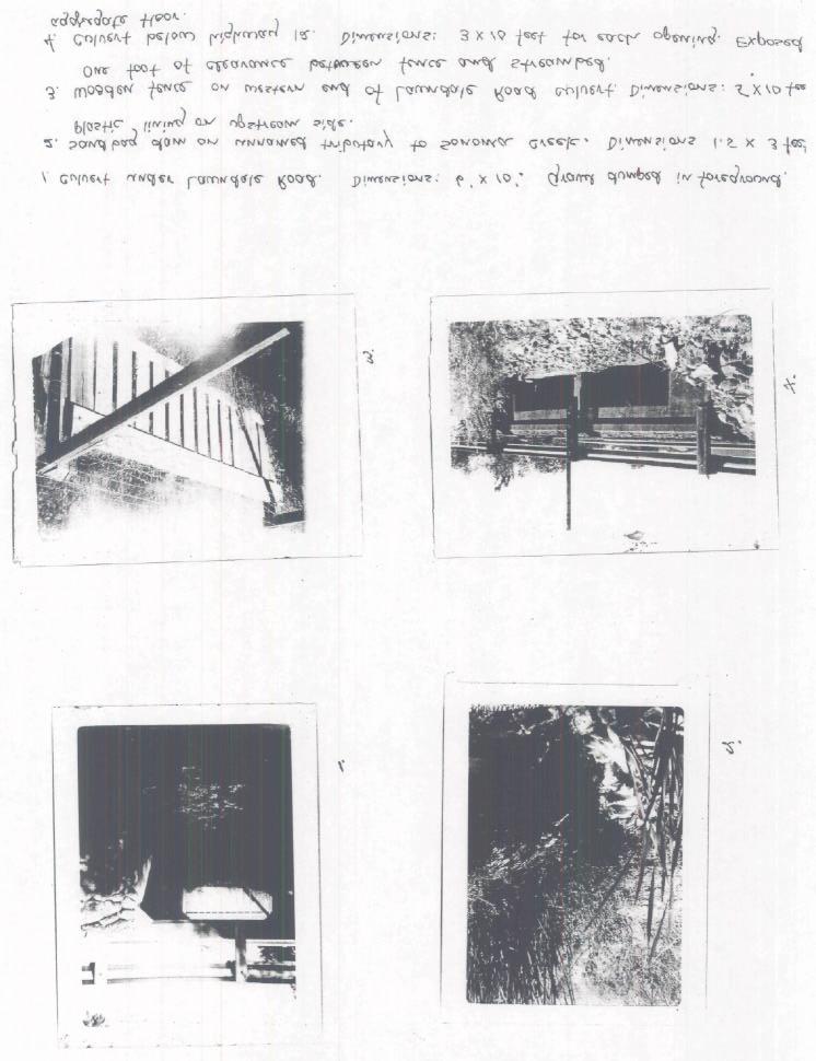
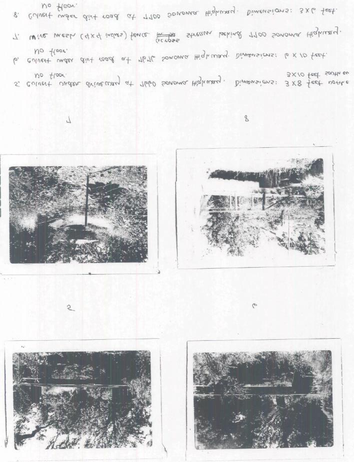
2 Unnamed Stream, Tributary to Sonoma Creek Page 2 Spawning Areas: The one-mile stretch of stream, between Highway 12 and the mouth, is good spawning habitat. The gravel is loose and is 50% fine gravel. Mr. Elwin G. Story has observed steelhead spawning near his house, at 7700 Sonoma Highway, during the 30 years he has lived there. He has not seen any sign of steelhead in the last five years, however. Pools: Pool development is poor; one pool per 1/4 mile. Size averages 3 x 6 feet with a depth of two feet in areas with water. Long stretches of dry ground serve to isolate pools during the summer. Shelter: There is little shelter in the pools. The roots from oaks and a few undercut banks provide a small amount of shelter in pools. Barriers: Above BM 857 (see sketch map) the gradient is quite steep. Roughs with 10 to 20 foot falls are not uncommon and probably limit upstream passage of fish. At Station 1 (see sketch map) there are two small (5 to 6 feet) concrete dams that collect water from the stream above. This water is piped down to three storage tanks (see accompanying slide 35 mm). Below the collecting ponds, the flow is subsurface for approximately 20 yards. The road over the creek, at this point, has no culvert. A small amount of seepage is visible just below the road, which is about 20' higher than the streambed. A 4-foot diameter culvert beneath the dirt road, just before it intersects Pythian Road, may provide a velocity barrier to fish during heavy winter flows. This appears to have happened in the winter of 1964/65 when water was backed up behind it (Willard L. Johnson, Jr.). There are eight culverts between Los Guilicos School and Sonoma Creek. Four of them (see a, b, c and d on sketch map) have concrete floors which may be barriers to upstream movement by fish when flows are low in late spring, or late fall. There are two (4 x 4-inch) wire mesh fences across the stream (see photo #7) between Highway 12 and the mouth. These have been installed recently and may be washed out during normal winter flows. A sandbag dam, 1 1/2 feet high and 3 feet across, blocks the unnamed tributary to Sonoma Creek. It, too, may not survive a normal winter. Two concrete and aggregate posts (1 x 1 x 6 feet) have been placed across the unnamed tributary to Sonoma Creek approximately 50 feet below the sandbag dam (see sketch map). The concrete posts would not be a barrier if the stream was more than one foot deep. Two board fences (see polaroid photos 1 and 3) have been built on either side of a cattle pasture west of Lawndale Road. They have a clearance of approximately 1 foot above the streambed at present, but may be a barrier to steelhead coming up from Sonoma Creek in the future, especially if the water level is high. Diversions: Water from the stream and its small tributaries is diverted into a reservoir on the Willard L. Johnson property (see R-l on the sketch map) during years of normal runoff. The maximum surface area is 4 acre-feet. At present, the water level is 25 feet below the top of the earth dam and is only 2 feet deep. A smaller reservoir (R-2 on sketch map) holds about 1 acre-foot and is spring-fed. A pipe connected to a pump diverts water from a pool (Station 2 on sketch map) west of BM 857. The pool was 10 x 2 feet and approximately 1 foot deep and appears to be spring-fed. Elvin G. Story, who resides at 7700 Sonoma Highway, says that the above diversions of water from the stream have cut off the flow completely at times during the last five years. In late spring, when streamflow ceases, adult steelhead who had not yet returned to Sonoma Creek are stranded. Mr. Story has rescued these fish by transporting them to Sonoma Creek. He and his neighbors hold the Johnson family responsible and have complained (not known to what agency) in the past. Temperatures: Station 1, above concrete holding pools, air temperature 55 F, water temperature 49 F at 1230 hours; and Station 2, pool near BM 857, air 65 F, water 51 F at 1300 hours. Food: Grasshoppers were abundant, as were crickets and small flying insects, where water was located; especially near the reservoirs. Aquatic Plants: Mats of filamentous green algae were present in ponds and reservoirs, as well as in slow-moving, shallow water in the stream itself. Duckweed was abundant in the pool below the reservoir (R-l on sketch map). There was little aquatic vegetation in the steep sections of stream (above Andrade house on sketch map). Wild celery, sedges, rushes and annual grasses were found in the unnamed tributary near Sonoma Creek.
3 Unnamed Stream, Tributary to Sonoma Creek Page 3 Winter Conditions: During normal winter run-off, the culvert beneath the dirt road (4 feet in diameter) above Andrade's house is about half full, according to Willard L. Johnson, Jr. In the severe winter of , the water backed up behind the culvert. Pollution: Solid waste from septic tanks of residences along the stream may contribute to pollution. Cattle wastes may go into the stream during the winter wet season. A pile of ashes, 10 x 15 feet, was found in the dry streambed approximately 500 feet below Highway 12. Springs: Springs provide water throughout the year, above Station 2. The small reservoir near the headwaters, is spring-fed as is the pool at Station 2. FISHES PRESENT AND SUCCESS: No fish were found in the survey. However, Mrs. Michael Andrade reported that four 6-inch trout were observed in the summer of 1976, in a small pool below her house. Mr. Johnson, Jr., reported stranded adult steelhead had died along the banks in the same area in Mr. Story reported adult steelhead and juveniles (2 to 6 inches) in the stream behind his house (7700 Sonoma Highway) up until He had fished the area with good success many years ago. OTHER VERTEBRATES: Frogs were seen near Sonoma Creek and bullfrogs were heard in the reservoirs. Cattle, dogs and horses are kept by residents. Raccoons and skunks were reported by Mrs. Andrade. Mr. Johnson killed a rattlesnake on Pythian Road while we were there. He also reported a great blue heron on the upper reservoir (R-2). FISHING INTENSITY: Light fishing intensity reported for years before No fishing at present. OTHER RECREATIONAL USES: The local residents use the area to hike and ride horses. ACCESSIBILITY: The stream parallels Pythian Road. Above Pythian is a dirt road maintain by Willard L. Johnson. Where this road forks are two locked gates. The stream is accessible from Highway 12 and by several private roads and driveways along Highway 12. The unnamed tributary can be reached by Lawndale Road. OWNERSHIP: North of Highway 12, the land adjacent to the stream belongs to Los Guilucos School (Sonoma County). Mr. and Mrs. Michael [Andrade] own the 8 acres between the school and BM 857. Willard L. Johnson owns the rest of the property north to the headwaters of the creek. South of Highway 12, ownership is divided among several residents. POSTED OR OPEN: The stream as well as the unnamed tributary into which it flows, is posted along its entire length with "No Trespassing" signs. IMPROVEMENTS: The 1/2 mile of stream south of Highway 12 has been "improved" by the people who live along its banks. Rip-rapping and revetments, as well as a 10 x 15 feet concrete floor, are among the various streambed modifications in this area. PAST STOCKING: It is not known if the stream has ever been stocked. The four 6-inch trout observed by Mrs. Andrade's family in 1976 may have been put there. The reservoirs R-l and R-3 (sketch map) have been stocked with largemouth bass, bluegill and Gambusia according to Mr. Johnson, Jr., and Mrs. Andrade. GENERAL ESTIMATE: The one-mile stretch of stream between Highway 12 and the mouth, has been used in the past by steelhead. It provides good spawning habitat. The diversion of water into reservoirs north of Highway 12 presents severe problems in late spring when the flow has been stopped completely stranding adult steelhead. RECOMMENDED MANAGEMENT: The section of stream south of Highway 12 has fisheries value and should be managed for steelhead. Removal of fences, if they are found to be barriers to the migration of steelhead to the spawning areas, is suggested. An agreement with Mr. Johnson to maintain normal flows in the late spring should be reached if steelhead are to return to this stream. SKETCH MAP: Attached. PHOTOGRAPHS: Attached. REFERENCES AND MAPS: U.S.G.S. 7.5' series map for the Kenwood quadrangle, California.
4
5
6
STREAM SURVEY File form No..
 scanned for KRIS THE RESOURCES AGENCY OF CALIFORNIA California Department of Fish and Game STREAM SURVEY File form No.. Date: September 4, 1969. NAME: North Fork Schooner Gulch Creek COUNTY: Mendocino.
THE RESOURCES AGENCY OF CALIFORNIA Department of Fish and Game STREAM SURVEY
 File form No.. Date: 4/1/73. NAME: Maacama Creek COUNTY: Sonoma. STREAM SECTION: FROM: Maacama Creek Ranch TO: Chalk Hill Rd. Bridge LENGTH: 1.5 mi.. Bridge OTHER NAMES: Weather - Clear & Sunny RIVER SYSTEM:
5B. Management of invasive species in the Cosumnes and Mokelumne River Basins
 5B. Management of invasive species in the Cosumnes and Mokelumne River Basins Cosumnes River The Cosumnes River basin has a number of distinct habitat types that require different management strategies
Newaukum Watershed Culvert Assessment
 Newaukum Watershed Culvert Assessment Water Resource Inventory Area 23 Lewis County Conservation District Final Report By: Kelly Verd and Nikki Wilson July 2002 Funded by: Chehalis Fisheries Restoration
Interim Guidance Fish Presence Absence
 Interim Guidance Fish Presence Absence Source: Forest Practices Act Guidance for Division 635 of the forest practices act dealing with stream classification when no fish surveys have been done (referenced
Illinois Lake Management Association Conference March 23, 2018 By Trent Thomas Illinois Department of Natural Resources Division of Fisheries
 Illinois Lake Management Association Conference March 23, 2018 By Trent Thomas Illinois Department of Natural Resources Division of Fisheries Sources of Habitat Impairment Sedimentation Channelization
Minnesota Department of Natural Resources Division of Fish and Wildlife Section of Fisheries. Stream Survey Report. Luxemburg Creek.
 Minnesota F-29-R(P)-24 Area 315 Study 3 March 2016 Minnesota Department of Natural Resources Division of Fish and Wildlife Section of Fisheries Stream Survey Report Luxemburg Creek 2015 Mark Pelham Sauk
WFC 50 California s Wild Vertebrates Jan. 11, Inland Waters (Lakes and Streams) Lisa Thompson
 Lisa Thompson") Inland Waters: Lakes and Streams WFC 50 11 January 2011 Lisa Thompson Fisheries Extension Specialist Wildlife, Fish, & Conservation Biology Department University of California, Davis Take home messages
Inland Waters: Lakes and Streams WFC 50 11 January 2011 Lisa Thompson Fisheries Extension Specialist Wildlife, Fish, & Conservation Biology Department University of California, Davis Take home messages
Warden Tom Kasnick August 30, 1983
 scanned for KRIS Franz Creek Warden Tom Kasnick August 30, 1983 - Region 3 Franz Creek, Sonoma County - Fish Kill and Pollution Incident On August 3, 1983, you requested that I investigate a reported fish
Historical Distribution and Current Status of Steelhead/Rainbow Trout (Oncorhynchus mykiss) in Streams of the San Francisco Estuary, California
 in Streams of the San Francisco Estuary, California") Historical Distribution and Current Status of Steelhead/Rainbow Trout (Oncorhynchus mykiss) in Streams of the San Francisco Estuary, California Robert A. Leidy, Environmental Protection Agency, San Francisco,
Historical Distribution and Current Status of Steelhead/Rainbow Trout (Oncorhynchus mykiss) in Streams of the San Francisco Estuary, California Robert A. Leidy, Environmental Protection Agency, San Francisco,
Big Spring Creek Habitat Enhancement and Fishery Management Plans
 Big Spring Creek Habitat Enhancement and Fishery Management Plans November 5, 2012 Big Spring Events and Activities Center Newville, PA Charlie McGarrell Regional Habitat Biologist Pennsylvania Fish and
STEELHEAD SURVEYS IN OMAK CREEK
 STEELHEAD SURVEYS IN OMAK CREEK 2002 Annual Report Prepared by Chris Fisher John Arterburn Colville Confederated Tribes Fish and Wildlife Department P.O. Box 150 Nespelem, WA 99155 Prepared for Project
FINAL REPORT. Yonkers Creek Migration Barrier Removal Project Wonderstump Road Del Norte County. Submitted By:
 FINAL REPORT Yonkers Creek Migration Barrier Removal Project Wonderstump Road Del Norte County Submitted By: Del Norte County Community Development Department Yonkers Creek Migration Barrier Removal Project
Juvenile Steelhead and Stream Habitat Conditions Steelhead and Coho Salmon Life History Prepared by: DW ALLEY & Associates, Fishery Consultant
 Juvenile Steelhead and Stream Habitat Conditions Steelhead and Coho Salmon Life History Prepared by: DW ALLEY & Associates, Fishery Consultant I-1. Steelhead and Coho Salmon Ecology Migration. Adult steelhead
Chinook Salmon Spawning Study Russian River Fall 2005
 Chinook Salmon Spawning Study Russian River Fall 2005 Sonoma County Water Agency 2150 West College Avenue Santa Rosa, California 95401 Prepared by David Cook - Senior Environmental Specialist March 27,
NEVADA DEPARTMENT OF WILDLIFE STATEWIDE FISHERIES MANAGEMENT
 NEVADA DEPARTMENT OF WILDLIFE STATEWIDE FISHERIES MANAGEMENT FEDERAL AID JOB PROGRESS REPORTS F-20-52 2016 Lake Tahoe Rainbow Trout Study WESTERN REGION NEVADA DEPARTMENT OF WILDLIFE, FISHERIES DIVISION
South Fork Chehalis Watershed Culvert Assessment
 South Fork Chehalis Watershed Culvert Assessment Water Resource Inventory Area 23 Lewis County Conservation District Final Report By: Kelly Verd and Nikki Wilson March 2003 Funded by: The Washington State
Annual Report for Fiscal Year and Future Plans for the Tillamook Bay Watershed Council
 Annual Report for Fiscal Year 2012-2013 and Future Plans for the Tillamook Bay Watershed Council A report prepared for the Tillamook County Board of Commissioners August 2013 Table of Contents: Recently
FISH PASSAGE IMPROVEMENT in California s Watersheds. Assessments & Recommendations by the Fish Passage Forum
 FISH PASSAGE IMPROVEMENT in California s Watersheds Assessments & Recommendations by the Fish Passage Forum FISH PASSAGE IMPROVEMENT in California s Watersheds The mission of the Fish Passage Forum is
January, same manner that stirring a fire hastens its burning.
 January, 1932 9 Checking Gully Erosion on Golf Courses By R. E. Uhland Superintendent, Soil Erosion Experiment Station, Bethany, Mo. No one will deny that good greens and fairways are essential to a good
PROJECT TO INSTALL LARGE WOOD HABITAT STRUCTURES IN THE CARMEL RIVER USING CALIFORNIA DEPARTMENT OF FISH AND GAME GRANT FUNDS
 PROJECT TO INSTALL LARGE WOOD HABITAT STRUCTURES IN THE CARMEL RIVER USING CALIFORNIA DEPARTMENT OF FISH AND GAME GRANT FUNDS The Monterey Peninsula Water Management District (MPWMD), in cooperation with
Searsville Dam Removal
 Searsville Dam Removal A unique opportunity for all Presented by the Beyond Searsville Dam Coalition San Francisquito Creek flows into the San Francisco Bay near the Palo Alto Airport and Golf Course seen
(Revised February,2005) CULVERTS, BRIDGES, AND FORDS
 CULVERTS, BRIDGES, AND FORDS") GUIDE TO STREAM CROSSINGS (Revised February,2005) CULVERTS, BRIDGES, AND FORDS Culverts, bridges, and fords are all methods used to cross-streams. Culverts are the most common stream crossing structure.
GUIDE TO STREAM CROSSINGS (Revised February,2005) CULVERTS, BRIDGES, AND FORDS Culverts, bridges, and fords are all methods used to cross-streams. Culverts are the most common stream crossing structure.
Five Counties Salmonid Conservation Program - Fish Passage Design Workshop. February 2013
 Program - Aquatic Organisms and Stream Crossings Ecological Connectivity A watershed is a network of channels that drain a common boundary. Channel characteristics formed by interaction of precipitation,
Abundance of Steelhead and Coho Salmon in the Lagunitas Creek Drainage, Marin County, California
 scanned for KRIS Abundance of Steelhead and Coho Salmon in the Lagunitas Creek Drainage, Marin County, California Prepared for: Marin Municipal Water District 220 Nellen Drive Corte Madera, California
Water of the Rogue Valley
 Water of the Rogue Valley An Activity Book for Grades 3-5 Welcome! You are about to embark on a journey of exploration. Your adventure begins at school and continues at North Mountain Park. This workbook
Executive Summary. Map 1. The Santa Clara River watershed with topography.
 Santa Clara River Steelhead Trout: Assessment and Recovery Opportunities December 2005 Prepared By: Matt Stoecker and Elise Kelley, Ph.D. University of California, Santa Barbara Prepared For: The Santa
Steelhead/rainbow trout resources of the Eel River watershed
 Steelhead/rainbow trout resources of the Eel River watershed The Eel River flows northwesterly, entering the Pacific Ocean about 13.5 miles south of Eureka. It is the third largest river system in California
Historical Distribution and Current Status of Steelhead/Rainbow Trout (Oncorhynchus mykiss) in Streams of the San Francisco Estuary, California
 in Streams of the San Francisco Estuary, California") Historical Distribution and Current Status of Steelhead/Rainbow Trout (Oncorhynchus mykiss) in Streams of the San Francisco Estuary, California Robert A. Leidy, Environmental Protection Agency, San Francisco,
Historical Distribution and Current Status of Steelhead/Rainbow Trout (Oncorhynchus mykiss) in Streams of the San Francisco Estuary, California Robert A. Leidy, Environmental Protection Agency, San Francisco,
STREAM CLASSIFICATION AND MAPPING. Prepared For. MacMillan Bloedel Ltd. Menzies Bay Division BOX 6000, Campbell River V9W 5E1.
 STREAM CLASSIFICATION AND MAPPING OF STREAMS IN MENZIES AND OYSTER BAY Prepared For MacMillan Bloedel Ltd. Menzies Bay Division BOX 6000, Campbell River V9W 5E1 September 1998 a a North Island Biological
Rehabilitation of Grimes Creek, a Stream Impacted in the Past by Bucket-lined Dredge Gold Mining, Boise River Drainage, July 2008 to August 2011.
 Rehabilitation of Grimes Creek, a Stream Impacted in the Past by Bucket-lined Dredge Gold Mining, Boise River Drainage, July 2008 to August 2011. Pam Harrington TU,1020 W. Main Street Suite 440, Boise,
Guide to the UNDERC Stream Network
 Guide to the UNDERC Stream Network Tony Hollowell Bios 569 Practicum in Field Biology July 22, 23 Introduction While the UNDERC lakes have been described extensively and are well known, the UNDERC stream
Fish Migration Barrier Severity and Steelhead Habitat Quality in the Malibu Creek Watershed
 Fish Migration Barrier Severity and Steelhead Habitat Quality in the Malibu Creek Watershed Produced for California State Coastal Conservancy and California Department of Parks and Recreation By: Heal
6TH PELLETIER BROOK LAKE T15 R9, Aroostook Co. U.S.G.S. Gardner Pond, Maine (7 1/2 )
") 6TH PELLETIER BROOK LAKE T15 R9, Aroostook Co. U.S.G.S. Gardner Pond, Maine (7 1/2 ) Fishes Brook trout Minnows Blacknose dace Pearl dace Physical Characteristics Area - 27 acres Average depth - 2 feet
6TH PELLETIER BROOK LAKE T15 R9, Aroostook Co. U.S.G.S. Gardner Pond, Maine (7 1/2 ) Fishes Brook trout Minnows Blacknose dace Pearl dace Physical Characteristics Area - 27 acres Average depth - 2 feet
Mr. Michael Malone CPS Energy 145 Navarro Street, Mail Drop San Antonio, Texas Project No
 October 17, 2016 Mr. Michael Malone CPS Energy 145 Navarro Street, Mail Drop 100406 San Antonio, Texas 78296 Project No. 0352436 Subject: Compilation of Construction History Calaveras Power Station San
STREAM Girls field notebook
 s STREAM Girls field notebook Welcome...... to your stream! Trout Unlimited is excited to offer you and other Girl Scouts the chance to really get to know your home waters. Over the next three days, you
NEVADA DEPARTMENT OF WILDLIFE STATEWIDE FISHERIES MANAGEMENT
 NEVADA DEPARTMENT OF WILDLIFE STATEWIDE FISHERIES MANAGEMENT FEDERAL AID JOB PROGRESS REPORTS F-20-52 2016 EAST FORK AND MAIN STEM CARSON RIVER WESTERN REGION NEVADA DEPARTMENT OF WILDLIFE, FISHERIES DIVISION
REPORT TO THE MINISTER OF NATURAL RESOURCES. Pursuant to an appointment made by the Honourable Frank S. Miller, Minister of Natural
 Room 569, Fifth Floor, Mowat Block, Queen's Park, Toronto, Ontario. M7A la2 IN THE MATTER OF The Lakes and Rivers Improvement Act; AND IN THE MATTER OF An application by Rudolph Adam for approval under
Columbia Lake Dam Removal Project
 Columbia Lake Dam Removal Project The Columbia Lake dam located 1/4 mile upstream of the Paulins Kill River's confluence with the Delaware River in Knowlton Township, Warren County has been proposed for
Climate Change Adaptation and Stream Restoration. Jack Williams;
 Climate Change Adaptation and Stream Restoration Jack Williams; jwilliams@tu.org 1 Goals for this presentation Develop strategies for adapting streams to climate impacts by Thinking like a watershed Understanding
REC 6 FISHERIES HABITAT EVALUATION
 REC 6 FISHERIES HABITAT EVALUATION 1.0 EXECUTIVE SUMMARY Analysis of fisheries habitat for recreational angling opportunities was completed by reviewing the results of the CAWG 1, Characterize Stream and
Minnesota Department of Natural Resources Division of Fish and Wildlife Section of Fisheries. Stream Survey Report. Cold Spring Creek.
 Minnesota F-29-R(P)-24 Area 315 Study 3 March 2013 Minnesota Department of Natural Resources Division of Fish and Wildlife Section of Fisheries Stream Survey Report Cold Spring Creek 2012 Mark Pelham Montrose
Michigan Department of Natural Resources Status of the Fishery Resource Report Page 1
 Michigan Department of Natural Resources 2008-59 Status of the Fishery Resource Report Page 1 Bowens Manistee County, (T24N R16W Sec. 11, 12, 13, 14, 15, 24, and 30). Last surveyed 2008 Mark A. Tonello
Pre-Application Document Kaweah Project (FERC Project No. 298)
") TABLE OF CONTENTS Page 3.12 Aesthetic Resources... 3.12-1 3.12.1 Information Sources... 3.12-1 3.12.2 Setting... 3.12-1 3.12.3 Project Facilities... 3.12-2 3.12.4 Previous Visual Resources Assessment...
TABLE OF CONTENTS Page 3.12 Aesthetic Resources... 3.12-1 3.12.1 Information Sources... 3.12-1 3.12.2 Setting... 3.12-1 3.12.3 Project Facilities... 3.12-2 3.12.4 Previous Visual Resources Assessment...
Mid-Columbia Fisheries Enhancement Group Annual Report Fiscal Year 06: July 1, 2005 June 30, 2006
 Mid-Columbia Fisheries Enhancement Group Annual Report Fiscal Year 06: July 1, 2005 June 30, 2006 Mission Statement The mission of the Mid-Columbia Fisheries Enhancement Group is to restore self-sustaining
Minnesota Department of Natural Resources Division of Fish and Wildlife Section of Fisheries. Fairhaven Creek 2000
 Minnesota F-29-R(P)-17 Area 340 Study 3 April 2001 Minnesota Department of Natural Resources Division of Fish and Wildlife Section of Fisheries Stream Survey Report Fairhaven Creek 2000 By Eric R. Altena
Summer Steelhead Surveys North Fork Trinity River Trinity County, California
 KRIS edition Summer Steelhead Surveys North Fork Trinity River Trinity County, California 1978-1997 By Loren Everest Fishery Biologist Weaverville Ranger District Shasta-Trinity National Forests October
Holderness. The Three Watersheds within the Newfound Lake Drainage Dorchester. Groton Plymouth. Ashland. Hebron. Canaan. Bridgewater.
 Background Brook trout are the only native stream dwelling trout species in New Hampshire, having a historic range that extended from Georgia to eastern Canada. It is believed that wild brook trout were
Downstream Migrant Trapping in Russian River Mainstem, Tributaries, and Estuary
 Downstream Migrant Trapping in Russian River Mainstem, Tributaries, and Estuary Introduction In September 2008, the National Marine Fisheries Service issued the Russian River Biological Opinion, which
Wild Fish Conservancy Watertype Assessment Project Summary West Sound Watersheds Phase II October 2014
 Wild Fish Conservancy Watertype Assessment Project Summary West Sound Watersheds Phase II http://www.wildfishconservancy.org/maps October 2014 Water typing is the state-sanctioned process of mapping the
Coho Salmon 1. COMMON NAMES: Silver salmon, Coho, blue back, silversides, and jack salmon.
 Coho Salmon 1 BACKGROUND 2 COMMON NAMES: Silver salmon, Coho, blue back, silversides, and jack salmon. DESCRIPTION: In the ocean the Coho is metallic blue on its back with silvery sides and white bellies.
Tittabawassee River Assessment. Miles. Gladwin Smallwood Impoundment. Harrison. Clare. Midland. Mt. Pleasant. St. Louis. Saginaw.
 Warmouth Lepomis gulosus feeding - clear lakes and impoundments and very low-gradient streams - abundant aquatic vegetation - silt-free water - mucky substrate often covered with organic debris spawning
Manual of Fisheries Survey Methods II: with periodic updates. Chapter 22: Guidelines for Sampling Warmwater Rivers with Rotenone
 Manual of Fisheries Survey Methods II: with periodic updates : Guidelines for Sampling Warmwater Rivers with Rotenone P. W. Seelbach, G. L. Towns, and D. D. Nelson Suggested citation: Seelbach, Paul W.,
Suitable Applications Check dams may be appropriate in the following situations: To promote sedimentation behind the dam.
 Categories EC Erosion Control SE Sediment Control TC Tracking Control WE Wind Erosion Control Non-Stormwater NS Management Control Waste Management and WM Materials Pollution Control Legend: Primary Category
f Agricultural S c i e n c SMALL EARTH DAMS LLOYD N. BROWN ^ CALIFORNIA AGRICULTURAL CIRCULAR 467 \ Experiment Station Extension Service
 f Agricultural S c i e n c SMALL EARTH DAMS LLOYD N. BROWN ^ CALIFORNIA AGRICULTURAL \ Experiment Station Extension Service CIRCULAR 467 Crest of dam Dry face slope 2 to 1 Downstream toe About 10,000 small
Study Update Tailrace Slough Use by Anadromous Salmonids
 Study Update Tailrace Slough Use by Anadromous Salmonids Goals and Objectives Identify what anadromous salmonids use the tailrace slough by: Life Stage (Juvenile, migrating and spawning adults) Timing
COA-F17-F-1343 YEAR END REPORT
 DAVE MARSHALL SALMON RESERVE RESTORATION, MAINTENANCE, AND UPGRADES YEAR END REPORT Prepared for: Fish and Wildlife Compensation Program Prepared by: Edith Tobe, RPBio, Executive Director Box 1791, Squamish,
Upper/Lower Owl Creek Reservoir
 Upper/Lower Owl Creek Reservoir Schuylkill County 2018 Largemouth Bass Survey Upper Owl Creek Reservoir and Lower Owl Creek Reservoir are 67-acre and 26-acre impoundments, respectively, created by two
Study Update Fish Distribution and Species Composition
 Study Update Fish Distribution and Species Composition Goals and Study Area Gain a better understanding of fish species composition and abundance in waters associated with the Packwood Lake Hydroelectric
SKIATOOK LAKE MANAGEMENT PLAN
 SKIATOOK LAKE MANAGEMENT PLAN Background Skiatook Lake impounds Hominy Creek, 5 miles west of Skiatook in Osage County, Oklahoma (Figure 1). Skiatook Lake covers 10,540 surface acres and was constructed
OREGON DEPARTMENT OF FISH AND WILDLIFE ROGUE FISH DISTRICT REPORT
 OREGON DEPARTMENT OF FISH AND WILDLIFE ROGUE FISH DISTRICT REPORT TITLE: Upper Rogue Smolt Trapping Project, 1999 STREAM: Big Butte, Little Butte, South Fork Big Butte, Slate and West Fork Evans Creeks
Stevens Creek Corridor
 O F F I C E O F T H E D I R E C T O R O F P U B L I C W O R K S Stevens Creek Corridor Creek Restoration Project Volume Three Project Update: Creek Photos, Before & After BY GAIL SEEDS - PROJECT MANAGER,
Minnesota Department of Natural Resources Division of Fish and Wildlife Section of Fisheries. Stream Survey Report. Cold Spring Creek.
 Minnesota F-29-R(P)-24 Area 315 Study 3 March 2015 Minnesota Department of Natural Resources Division of Fish and Wildlife Section of Fisheries Stream Survey Report Cold Spring Creek 2014 Mark Pelham Montrose
HURON RIVER WATERSHED
 Brown bullhead (Ameiurus nebulosus) feeding - larger streams and rivers, lakes and impoundments - clear cool water with little clayey silt - moderate amounts of aquatic vegetation - sand, gravel, or muck
SOONER LAKE MANAGEMENT PLAN
 SOONER LAKE MANAGEMENT PLAN Background Lake Sooner impounds Greasy Creek, 15 miles south of Ponca City in Noble and Pawnee Counties, Oklahoma (Figure 1). The Grease Creek basin that Sooner Lake impounds
1.Mill Creek Watershed Summary Description and Land Use
 1.Mill Creek Watershed Summary Description and Land Use Table xxx: Mill Creek Watershed Overview Watershed Size 31,435 acres/49.1 sq miles/ 127.1 sq km Elevation Range 5,594 feet [4,967-10,561] Stream
The Calawah River System
 The Calawah River System The Calawah River is the largest tributary of the Bogachiel River and is formed by the confluence of the north and south forks of the Calawah. The two forks of the Calawah, CALAWAH
Circle W Ranch SPRAY, OREGON. Hunting Ranching Fly Fishing Conservation
 Circle W Ranch SPRAY, OREGON Hunting Ranching Fly Fishing Conservation Circle W Ranch SPRAY, OREGON CIntroduction The Circle W Ranch is located in North Central Oregon. The North border of the ranch runs
Gamefish Assessment Report
 MINNESOTA DEPARTMENT OF NATURAL RESOURCES Gamefish Assessment Report Spring Gamefish Assessment on the Mississippi River from Little Falls to Brainerd, MN May 31 through June 4, 2013 River Miles 966 to
JAP Additional Information Sheet
 JAP Additional Information Sheet Block 15: Purpose and Need The USACE purpose of the project is to provide a safe and reliable whitewater park for the recreational public in a city park, which will provide
Data Report : Russian River Basin Steelhead and Coho Salmon Monitoring Program Pilot Study
 Data Report 1999-1: Russian River Basin Steelhead and Coho Salmon Monitoring Program Pilot Study Sonoma County Water Agency 215 West College Avenue Santa Rosa, California 951 Prepared by David Cook Senior
THE GREAT SALMON RECOVERY HOAX. Having faithfully attended the Salmon Recovery Forum meetings for over a
 THE GREAT SALMON RECOVERY HOAX Having faithfully attended the Salmon Recovery Forum meetings for over a decade, and despite all the effort, as near as I can tell, we have recovered nothing. Lots of money
Fraser River. FISH SURVEY AND MANAGEMENT INFORMATION Jon Ewert - Aquatic Biologist (Hot Sulphur Springs)
") Fraser River FISH SURVEY AND MANAGEMENT INFORMATION Jon Ewert - Aquatic Biologist (Hot Sulphur Springs) General Information: The Fraser River is a highly diverse river offering many transitions in habitat
Fraser River FISH SURVEY AND MANAGEMENT INFORMATION Jon Ewert - Aquatic Biologist (Hot Sulphur Springs) General Information: The Fraser River is a highly diverse river offering many transitions in habitat
BIG TWIN LAKE Kalkaska County (T28N, R05W, Section 18, and T28N, R06W, Section 13) Surveyed May 1999
 Surveyed May 1999") Michigan Department of Natural Resources Status of the Fishery Resource Report No. 2001-1, Year 2001 BIG TWIN LAKE Kalkaska County (T28N, R05W, Section 18, and T28N, R06W, Section 13) Surveyed May 1999
Michigan Department of Natural Resources Status of the Fishery Resource Report No. 2001-1, Year 2001 BIG TWIN LAKE Kalkaska County (T28N, R05W, Section 18, and T28N, R06W, Section 13) Surveyed May 1999
Great Lakes Stream Crossing Inventory Instructions
 Great Lakes Stream Crossing Inventory Instructions This document is a guide to completing the Stream Crossing Data Sheet (2/28/11 version). Careful attention to this guidance will ensure consistent crossing
Final Bull Trout Redd Monitoring Report for the Wallowa Falls Hydroelectric Project
 Final for the Wallowa Falls Hydroelectric Project East Fork Wallowa River barrier to upstream fish migration, photo courtesy of Kendrick Moholt (FERC No. P-308) December 18, 2017 Prepared by: Jeremiah
Firth Creek Habitat Enhancement Project 1993
 Firth Creek Habitat Enhancement Project 1993 A. R. Langston December 1993 PWFWCP Report No. 77 The Peace/Williston Fish & Wildlife Compensation Program is a cooperative venture of BC Hydro and the provincial
LITTLE WHITE OAK Knox County 2006 Fish Management Report. Debbie King Assistant Fisheries Biologist
 LITTLE WHITE OAK Knox County 2006 Fish Management Report Debbie King Assistant Fisheries Biologist Fisheries Section Indiana Department of Natural Resources Division of Fish and Wildlife I.G.C.-South,
Redd Dewatering and Juvenile Salmonid Stranding in the Lower Feather River,
 Redd Dewatering and Juvenile Salmonid Stranding in the Lower Feather River, 2005-2006 Interim Report for NOAA Fisheries Prepared by: California Department of Water Resources Division of Environmental Services
DRAFT. Stonybrook Creek Watershed
 DRAFT Stonybrook Creek Watershed A Strategic Plan for Eliminating Barriers to Steelhead Migration June 4, 2010 Prepared by: PO Box 4477, Arcata, CA 95518 mlove@h2odesigns.com / (707) 476 8938 Prepared
NEVADA DEPARTMENT OF WILDLIFE STATEWIDE FISHERIES MANAGEMENT
 NEVADA DEPARTMENT OF WILDLIFE STATEWIDE FISHERIES MANAGEMENT FEDERAL AID JOB PROGRESS REPORTS F-20-50 2014 BILK CREEK RESERVOIR WESTERN REGION 1 NEVADA DEPARTMENT OF WILDLIFE, FISHERIES DIVISION JOB PROGRESS
Simulating Streams Through Culverts in Mat-Su, Alaska
 Simulating Streams Through Culverts in Mat-Su, Alaska Project Managers Bill Rice, P.E., USFWS Hydrologist Mary Price, USFWS Fishery Biologist The Team Approach US Fish and Wildlife Service Bill Rice, P.E.,
Amendment to a Biological Assessment/Evaluation completed for the Coon Creek Land Disposal completed December Grand Valley Ranger District
 Amendment to a Biological Assessment/Evaluation completed for the Coon Creek Land Disposal completed December 2007 Grand Valley Ranger District Grand Mesa, Uncompahgre, Gunnison National Forests Prepared
Potlatch River Drainage: Salmonid Presence: Largest lower Clearwater River tributary
 X Y Potlatch River Drainage: Largest lower Clearwater River tributary Area = 1500 km 2 Mouth ~ 13 km upstream of Snake/Clearwater confluence X Y Dominated by private land Salmonid Presence: Steelhead,
Regulations. Grabbling season May 1 July 15; only wooden structures allowed.
 Arkabutla Reservoir 219 REEL FACTS Keith Meals, Arthur Dunn, Stanley Turner Fisheries Biologists keithm@wfp.ms.gov, ArthurD@wfp.ms.gov, StanleyT@wfp.ms.gov General Information: Arkabutla Reservoir is one
Estimated on-the-ground start and end dates: 1 June October 2018
 A. Applicant Information Name of Organization: U.S. Army Corps of Engineers, Carlyle Lake 801 Lake Road, Carlyle, IL 62231 Contact Information: Robert Wilkins, Operations Manager, (618) 594-2484, Robert.Wilkins@usace.army.mil
Colusa Basin Drain Watershed Fish Stranding Tour Concept Paper Mike Hendrick and Brycen Swart NMFS
 Colusa Basin Drain Watershed Fish Stranding Tour Concept Paper Mike Hendrick and Brycen Swart NMFS On May 31, 2013 representatives from CDFW, USFWS, and NMFS went on a field tour to look at locations in
Don Pedro Project Relicensing
 Don Pedro Project Relicensing M ODESTO I RRIGATION D ISTRICT TURLOCK I RRIGATION D ISTRICT FERC PROJECT N O. 2299 Resident Fish in Don Pedro Reservoir Don Pedro Reservoir Fish Stocking (1971-Present) CDFG
Downstream Migrant Trapping in Russian River Mainstem, Tributaries, and Estuary
 Downstream Migrant Trapping in Russian River Mainstem, Tributaries, and Estuary Introduction In September 2008, the National Marine Fisheries Service issued the Russian River Biological Opinion, which
Quillback (Carpoides cyprinus)
") t. Joseph Assessment Appendix Quillback (Carpoides cyprinus) feeding - clear to turbid water - Michigan - sand, sandy gravel, sandy silt, or clay-silt substrate - medium- to low-gradient rivers and streams;
t. Joseph Assessment Appendix Quillback (Carpoides cyprinus) feeding - clear to turbid water - Michigan - sand, sandy gravel, sandy silt, or clay-silt substrate - medium- to low-gradient rivers and streams;
APPENDIX B: CATALOG OF HUMBOLDT COUNTY CULVERTS LOCATED ON FISH-BEARING STREAM REACHES
 APPENDIX B: CATALOG OF HUMBOLDT COUNTY CULVERTS LOCATED ON FISH-BEARING STREAM REACHES NOTE: This catalog contains a single page for each culvert included in the inventory. Generally, they are ordered
Steelhead/rainbow trout resources of San Luis Obispo County
 Steelhead/rainbow trout resources of San Luis Obispo County San Carpoforo (San Carpojo) San Carpoforo Creek (San Carpojo Creek) consists of more than ten stream miles. It flows southwest, entering the
Tuolumne River Gravel Introduction
 Tuolumne River Gravel Introduction 2000 2003 Tuolumne River La Grange Gravel Addition, Phase II Course Sediment Replenishment Program Tuolumne River Salmonid Habitat Improvement Project River Mile 49.9
Total Suspended Solids, Stable Flow, and Wet Weather Event Monitoring in the Unnamed Tributary to the Grand River Watershed.
 Total Suspended Solids, Stable Flow, and Wet Weather Event Monitoring in the Unnamed Tributary to the Grand River Watershed December 2004 The Cadmus Group, Inc. Grand Valley State University Annis Water
Project Report for Marsh Creek and Albion River Instream Fish Barrier Removal Flynn Creek Road, CR 135, M.P. 8.1 and 8.3
 Project Report for Marsh Creek and Albion River Instream Fish Barrier Removal Flynn Creek Road, CR 135, M.P. 8.1 and 8.3 Project Title: Marsh Creek and Albion River Instream Fish Barrier Removal, Flynn
Norwalk River. Ridgefield, Redding, Wilton & Norwalk
 FLY FISHING FAIRFIELD COUNTY Norwalk River Ridgefield, Redding, Wilton & Norwalk Fast Facts Length: 24 miles Width: 10-20 feet Depth: 2-3 feet Access: Excellent - Many town parks and open spaces Stocking:
COLUMBIA LAKE DAM REMOVAL PROJECT
 COLUMBIA LAKE DAM REMOVAL PROJECT Major Goals of the Columbia Lake Dam Removal: Reconnect 10 miles of the Paulins Kill River to the Delaware River, restoring natural flow regime and sediment transport.
Fish Passage Assessment of Private Stream Crossings on Lower Stonybrook Creek
 Fish Passage Assessment of Private Stream Crossings on Lower Stonybrook Creek Prepared by: Michael Love & Associates In cooperation with: Center for Ecosystem Management and Restoration Funded by: Coastal
River-Lab Grade 3 (RL3) Route Green & Yellow Deep River Pool Trail Guide
 Route Green & Yellow Deep River Pool Trail Guide") River-Lab Grade 3 (RL3) Route Green & Yellow Deep River Pool Trail Guide Route Green & Yellow Deep River Pool Trail Route Sequence Deep Pool Habitat Observation Marsh Habitat Observation Riffles Habitat
River-Lab Grade 3 (RL3) Route Green & Yellow Deep River Pool Trail Guide Route Green & Yellow Deep River Pool Trail Route Sequence Deep Pool Habitat Observation Marsh Habitat Observation Riffles Habitat
Massachusetts Stream Crossing Case Studies
 Massachusetts Stream Crossing Case Studies Amy Singler Associate Director, River Restoration Program Carrie Banks River Continuity Coordinator Case Studies: Public Benefits: Movement of goods and people