SELBY CREEK SILVERADO TRAIL CULVERT FISH PASSAGE ASSESSMENT
|
|
|
- Clarence Thornton
- 5 years ago
- Views:
Transcription
 252 4188 X 109 JONATHAN@NAPARCD.ORG PAUL D.")
1 SELBY CREEK SILVERADO TRAIL CULVERT FISH PASSAGE ASSESSMENT NAPA COUNTY, CALIFORNIA PREPARED BY NAPA COUNTY RESOURCE CONSERVATION DISTRICT 1303 JEFFERSON ST. SUITE 500B NAPA, CALIFORNIA OCTOBER, 2006 JONATHAN KOEHLER NCRCD SENIOR BIOLOGIST (707) X 109 JONATHAN@NAPARCD.ORG PAUL D. BLANK NCRCD HYDROLOGIST (707) X 112 PAUL@NAPARCD.ORG
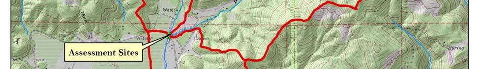
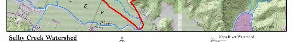
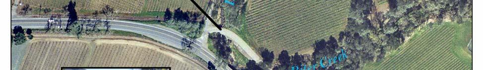
2 INTRODUCTION Selby Creek is formed by the junction of Dutch Henry Creek and Biter Creek, which join at the Silverado Trail (Figure 1). The Dutch Henry and Biter Creek watersheds cover an area of 5.19 square miles of primarily steep terrain dominated by oak woodland and chaparral with extensive rock outcroppings. The upper watershed that drains to the Silverado Trail culvert is largely undeveloped, with approximately 2.8% of its land area covered with vineyards and the remainder as open space and rural residential land. This report addresses fish passage conditions for steelhead (Oncorhynchus mykiss) at two potential impediments in Selby Creek and Dutch Henry Creek (Figure 2). The Silverado Trail crossing consists of a four-barrel concrete box culvert with a two-lane highway on top. Immediately upstream of this site is another culvert on Dutch Henry Road, a single lane road that crosses Dutch Henry Creek. The Dutch Henry crossing consists of a primary single-bore round steel culvert in the low flow channel and a secondary corrugated steel pipe arch at a slightly higher elevation. Both sites have been identified as potential fish migration barriers warranting thorough analysis of their severity. Steelhead are known to spawn and rear in Dutch Henry and Biter Creeks (Ecotrust & FONR 2002, NCRCD 2002). Juvenile steelhead densities appear to be relatively high in upper reaches that maintain perennial pools and high-quality habitat. Selby Creek is intermittent and goes completely dry every year by June. Due to this seasonal drying, Selby Creek acts primarily as a migration corridor for adult steelhead moving upstream to spawn in winter and juvenile steelhead migrating to the ocean (smolts) during spring. Partial migration barriers in this corridor could delay spawning by days or weeks and have negative effects on spawning success. Napa County RCD 2 Selby Creek Fish Passage Assessment

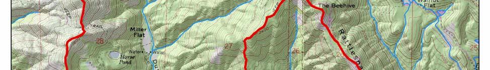
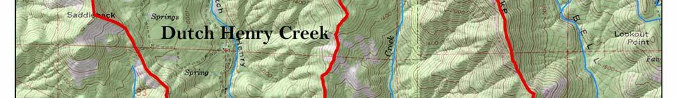
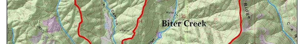
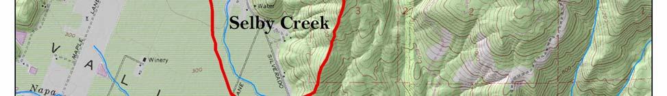
3 Figure 1. Selby Creek subwatershed map. Napa County RCD 3 Selby Creek Fish Passage Assessment

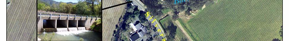
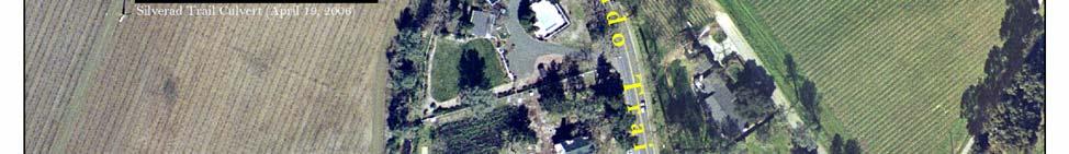
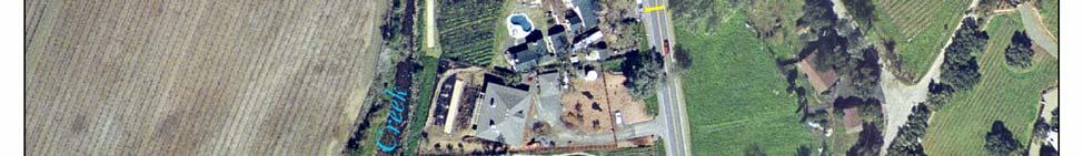
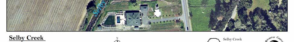
4 Figure 2. Fish passage assessment sites. Napa County RCD 4 Selby Creek Fish Passage Assessment
5 METHODS Fish passage was assessed following California Department of Fish & Game (DFG) protocols as described in the California Salmonid Stream Habitat Restoration Manual, Part IX. Field observations were made during late spring, 2006 with flows ranging from approximately 50 cubic feet per second (cfs) until the stream went dry in mid May. No streamgage or rainfall data were available for Selby Creek. Upper and lower fish passage flows were estimated from surrogate data in accordance with DFG protocols. RCD selected flow data from the former USGS streamgaging station on the Napa River in Calistoga. This was the gage nearest to Selby Creek with at least 5 years of daily average flows (8 years) and with a drainage area less then 50 square miles (22 square miles). Calculated fish passage flows were adjusted for Selby Creek by multiplying them by the ratio of the two drainage areas. The passage period was Dec 1 March 31, which corresponds with published and observed data for upstream steelhead migration timing. Downstream passage by adults and juveniles may extend into May, but the culvert does not hinder downstream movement. A TR-55 model was constructed to estimate discharge at standard return intervals. The model was built from GIS data on landuse, topography, and vegetation and rainfall data from NOAA Atlas 2. Natural Resource Conservation Service (NRCS) Agricultural Engineer, Carolyn Jones, constructed a simplified HEC-RAS model using visual estimates for channel geometry and roughness to calculate culvert capacity. In July 2006, Paul Blank and Jonathan Koehler surveyed the culvert sites and conducted thalweg surveys of Biter, Dutch Henry, and Selby Creeks. A cross-section survey of the downstream tailwater control for the Silverado Trail culvert was conducted by Paul Blank and Chad Edwards in August Hydraulic and topographic survey data were analyzed with Fish X-ing v This software is intended to assist engineers, hydrologists, and fish biologists in the evaluation and design of culverts for fish passage ( ). High and low passage flows were based on percent exceedance calculations. The low passage flow was three (cfs) and the high passage flow was 258 cfs. The low passage flow (3 cfs) represents the lowest expected flow during the migration period for adult steelhead. The high passage flow (258 cfs) represents the daily average flow that has a 1% chance of being exceeded between December and March in any given year. This range of flows encompasses the majority of flows that a migrating steelhead would encounter between December and March in Selby Creek. Swimming capabilities and minimum depth requirements for adult and juvenile steelhead were based on Table IX-6 in the California Salmonid Stream Habitat Restoration Manual and NOAA Fisheries Guidelines for Salmonid Passage at Stream Crossings. Napa County RCD 5 Selby Creek Fish Passage Assessment
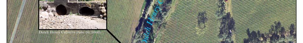
6 RESULTS AND DISCUSSION Dutch Henry Culvert Based on field observations and Fish X-ing analysis, this culvert does not represent a significant obstacle to steelhead migration. The culvert was given a GREEN value based on DFG criteria, which indicates that conditions are adequate for passage of all salmonid life stages. The main culvert is installed slightly below streambed level, maintains sufficiently low velocities during a wide range of flows, and is relatively short. The passage window analyzed was 3 70 cfs with Fish X-ing. The results of this analysis suggest that the culvert is passable during all but the lowest passage flows (< 5 cfs) for adults and passable during all passage flows for juveniles. Shallow conditions with water depths less than 0.5 feet in the culvert exist during low flows, which may slightly hinder fish passage. However, such shallow water depths are also expected in the natural channel above and below the culvert during such flows. Silverado Trail Culvert Fish X-ing analysis of the Silverado Trail culvert suggests that it is not passable for upstream migration by adult or juvenile steelhead. Based on our inputs, the culvert scored 0%, which is an impassable barrier. The culvert was given a RED value based on DFG criteria including excessive slope (greater than 3%) and an excessive outlet drop (greater than two feet). This indicates that this culvert does not meet current fish passage requirements and would be given a high priority ranking for modification or replacement. Our analysis was based on conservative swimming capabilities and minimum depth requirements from the DFG guidelines. Additionally, this analysis uses average water velocities to determine passage, which may not account for hydraulic variations, including velocity breaks near the culvert s edges. Margin areas with lower velocities may facilitate passage for juveniles and smaller adults under certain moderate to high flow conditions. Given these assumptions, the culvert is likely passable by some unknown fraction of the steelhead population with stronger swimming abilities during certain flows. However, DFG and NOAA Fisheries guidelines are designed to allow passage of all fish in the population, not just the strongest swimmers. The main obstacles for fish passage are lack of water depth within the culvert and high velocities from the steep slope (3.7%). The culvert is relatively wide, which promotes sheet flow (shallow, fast moving water) during most low to moderate flows. Under all conditions, the culvert is a complete barrier to juvenile upstream movement due to high velocities and the excessively high jump into the culvert outlet (Table 1). Napa County RCD 6 Selby Creek Fish Passage Assessment
7 Fish Passage Summary Low Passage Design Flow 3 cfs High Passage Design Flow 258 cfs Percent of Flows Passable 0.0 % Passable Flow Range None Depth Barrier 0 to 226 cfs Leap Barriers 83 cfs and above Velocity Barrier - EB 27 cfs and above Pool Depth Barrier 0 to 40 cfs Table 1. Silverado Trail culvert fish passage summary. The Silverado Trail culvert outlet is perched above the downstream pool, requiring a substantial leap into the culvert. Leap heights range from approximately 3.1 feet at the low passage flow (3 cfs) to about 2.1 feet at the high passage flow (258 cfs). These leap heights are well within documented adult steelhead leaping abilities of six feet or greater. However, the downstream jump pool is not deep enough to allow for efficient leaping. If a perched outlet is unavoidable, the downstream jump pool depth should be at least 1.25 times the leap height to create favorable hydraulic conditions for leaping. NOAA Fisheries and DFG guidelines recommend that all culverts be installed slightly below grade to eliminate leaping at the outlet. Repeated leap attempts cause exhaustion, injury, and even mortality to migrating fish. Results of our simplified HEC-RAS hydraulic model suggest that the culvert s capacity is approximately 1,600 cfs, which corresponds roughly to a 2 year return interval (Table 2). Flows above 1,600 cfs would be expected to cause flooding and ultimately overtopping of the roadway. The DFG and NOAA Fisheries guidelines recommend designing culverts to accommodate the 100 year flow to prevent failure and subsequent delivery of sediment downstream. Based on our hydraulic analysis, the culvert appears to be undersized to handle frequent flood flows. However, our qualitative observations of the site indicate that the culvert has roughly the same dimensions as the upstream and downstream channels. Due to the lack of rainfall and streamgage data for this watershed, all capacity and flow estimates should be interpreted to reflect these limitations. Year Storm (Return Interval) Peak Flow (cfs) 2 1, , , , , ,399 Table 2. Estimated discharges and return intervals at the Silverado Trail culvert. Napa County RCD 7 Selby Creek Fish Passage Assessment
8 RECOMMENDATIONS The culvert on Dutch Henry Creek does not warrant further action to improve fish passage. The current two-pipe configuration allows full passage during all expected steelhead migration flows and the structures appear to be in good physical condition. The Silverado Trail culvert represents a major obstacle for steelhead migration, and likely has a significant impact on fish movement to high quality upstream habitat. The culvert should be either replaced or modified to reduce water velocities, concentrate flows into a deeper low-flow lane, and eliminate the leap at the outlet. Since the culvert appears to be undersized, it is not advisable to improve passage by installing roughness elements (e.g. boulders, baffles, concrete berms, etc.) inside the culvert to decrease velocities and create resting areas. The channel downstream of the Silverado Trail culvert shows evidence of incision, and is characterized by steep, unstable banks. The culvert is currently providing grade control to the channel, preventing incision from traveling upstream into Dutch Henry and Biter Creeks. Restoration efforts in this downstream reach could include elements that sequentially raise the bed elevation over several hundred feet of channel. This may include a series of constructed step pools or other instream structures that promote bed aggradation. If the culvert remained in place and an improved approach route was created, the culvert itself would still remain a significant barrier, requiring modification to reduce velocities and increase depth. This may be partially accomplished by creating a notched lane in the concrete that concentrates flow through the culvert. This lane would likely only be effective at lower flows when velocities are lowest. REFERENCES California Department of Fish and Game Culvert Criteria for Fish Passage. Ecotrust, and FONR Results of Hankin-Reeves standard uncalibrated O. mykiss survey of Napa River tributaries, Portland, OR. Flosi, G., Downie, S., Hopelain, J., Bird, M., Coey, R., and Collins, B California Salmonid Stream Habitat Restoration Manual, 3rd edition. California Department of Fish and Game, Sacramento, CA. Napa County Resource Conservation District Northern Napa River Watershed Plan. Napa, CA. NOAA Fisheries Guidelines for Salmonid Passage at Stream Crossings. Napa County RCD 8 Selby Creek Fish Passage Assessment
9 APPENDICES SILVERADO TRAIL CULVERT SUMMARY DATA Adult Fish Length: 40 cm Minimum Water Depth: 0.6 ft Prolonged Swimming Speed: 6 ft/s Prolonged Time to Exhaustion: 30 min Species: Oncorhynchus mykiss (Steelhead) Temp: 10 to 19 Deg C Fish Body Depth: 0.29 ft Burst Swimming Speed: 10 ft/s Burst Time to Exhaustion: 5 s Burst Swimming Speed: 10 ft/s Burst Time to Exhaustion: 5 s Species: Oncorhynchus mykiss (Steelhead) Length: 10.3 to 81.3 cm Temp: 7 to 19 Deg C Swim Time: 1-20 s Fish Body Depth: 0.29 ft Fish Metrics Calculated Leaping Speed: 15 ft/s Velocity Reduction Factors: Inlet: 1.00 Barrel: 1.00 Outlet: 1.00 Crossing Installation Data Culvert Type: 32 X 5.95 ft Box Material: Concrete Installation: Not Embedded Culvert Length: 43 ft Culvert Slope: 3.72% Culvert Roughness Coefficient: Inlet Invert Elevation: ft Outlet Invert Elevation: ft Inlet Headloss Coefficient (Ke): 0.5 Design Flows Low Passage Flow: 3 cfs High Passage Flow: 258 cfs Tailwater Information Napa County RCD 9 Selby Creek Fish Passage Assessment
10 Tailwater Option: Tailwater Channel Cross-Section Channel Bottom Slope: 2% Outlet-Pool Bottom Elevation: 86.2 ft Tailwater Cross Section Data. Station (ft) Elevation (ft) Roughness Coefficient Napa County RCD 10 Selby Creek Fish Passage Assessment
11 SELBY CREEK EXCEEDENCE FLOW CALCULATIONS (DEC 1 MAR 31) Stream of Interest: Selby Creek Drainage Area (A ug ): 5.19 mi 2 Gaged Stream: Napa R at Calistoga Drainage Area (A g ): 21.9 mi 2 Period of Daily Q Record: 1976 to 1983 Passage Period: Dec1 Mar 31 No of records (n): 970 Exceedance Flow (%) Rank (m) Q gaged (cfs) A ug /A g Q ungaged (cfs) Selby Creek Thalweg Profile (2006) Elevation (ft relative to arbitrary datum) Dutch Henry Culvert Inlet Dutch Henry Culvert Outlet Silverado Trail Culvert Inlet Silverado Trail Culvert Outlet Downstream Tailwater Control Distance (ft) Napa County RCD 11 Selby Creek Fish Passage Assessment
 Silverado Trail culvert inlet")

12 Silverado Trail culvert facing upstream ( ) Silverado Trail culvert inlet facing downstream ( ) Napa County RCD 12 Selby Creek Fish Passage Assessment
 Silverado Trail culvert")

13 Selby Creek downstream of Silverado Trail facing downstream ( ) Silverado Trail culvert downstream standing on left bank ( ) Napa County RCD 13 Selby Creek Fish Passage Assessment


14 Silverado Trail culvert downstream standing right bank ( ) Dutch Henry Culvert inlet facing downstream ( ) Napa County RCD 14 Selby Creek Fish Passage Assessment
FISH PASSAGE IMPROVEMENT in California s Watersheds. Assessments & Recommendations by the Fish Passage Forum
 FISH PASSAGE IMPROVEMENT in California s Watersheds Assessments & Recommendations by the Fish Passage Forum FISH PASSAGE IMPROVEMENT in California s Watersheds The mission of the Fish Passage Forum is
Fish Passage Assessment of Private Stream Crossings on Lower Stonybrook Creek
 Fish Passage Assessment of Private Stream Crossings on Lower Stonybrook Creek Prepared by: Michael Love & Associates In cooperation with: Center for Ecosystem Management and Restoration Funded by: Coastal
Five Counties Salmonid Conservation Program - Fish Passage Design Workshop. February 2013
 Program - Aquatic Organisms and Stream Crossings Ecological Connectivity A watershed is a network of channels that drain a common boundary. Channel characteristics formed by interaction of precipitation,
Aquatic Organism Passage at Road-Stream Crossings CHUCK KEEPORTS FOREST HYDROLOGIST ALLEGHENY NATIONAL FOREST WARREN, PENNSYLVANIA
 Aquatic Organism Passage at Road-Stream Crossings CHUCK KEEPORTS FOREST HYDROLOGIST ALLEGHENY NATIONAL FOREST WARREN, PENNSYLVANIA TOPICS COVERED Aquatic Organism Passage (AOP) Benefits of AOP Crossings
CALIFORNIA SALMONID STREAM HABITAT RESTORATION MANUAL APPENDIX IX-A CULVERT CRITERIA FOR FISH PASSAGE INTRODUCTION
 APPENDIX IX-A STATE OF CALIFORNIA RESOURCES AGENCY DEPARTMENT OF FISH AND GAME CULVERT CRITERIA FOR FISH PASSAGE For habitat protection, ecological connectivity should be a goal of stream-road crossing
Stream Crossings I: Engineering and Design Approaches to Provide Fish Passage at Culvert Slipline Projects in Connecticut
 University of Massachusetts - Amherst ScholarWorks@UMass Amherst International Conference on Engineering and Ecohydrology for Fish Passage International Conference on Engineering and Ecohydrology for Fish
FINAL REPORT. Yonkers Creek Migration Barrier Removal Project Wonderstump Road Del Norte County. Submitted By:
 FINAL REPORT Yonkers Creek Migration Barrier Removal Project Wonderstump Road Del Norte County Submitted By: Del Norte County Community Development Department Yonkers Creek Migration Barrier Removal Project
Indiana LTAP Road Scholar Core Course #10 Culvert Drainage. Presented by Thomas T. Burke, Jr., PhD, PE Christopher B. Burke Engineering, Ltd.
 Indiana LTAP Road Scholar Core Course #10 Culvert Drainage Presented by Thomas T. Burke, Jr., PhD, PE Christopher B. Burke Engineering, Ltd. Objectives Review culvert shapes, end sections, and materials
Culvert Design for Low and High Gradient Streams in the Midwest. Dale Higgins, Hydrologist Chequamegon-Nicolet National Forest
 Culvert Design for Low and High Gradient Streams in the Midwest Dale Higgins, Hydrologist Chequamegon-Nicolet National Forest Overview Culvert Design Considerations Hydraulic Terms Culvert Impacts Low
Fish Passage at Road Crossings Assessment Boise National Forest FY 2004
 Culvert Inventory Summary 2004 - Boise National Forest Fish Passage at Road Crossings Assessment Boise National Forest FY 2004 Feather River at Road #135 Crossing By Michael S. Kellett, Fishery Biologist
2 nd Steelhead Summit. October 27 & 28, 2016 in San Luis Obispo, CA
 + 2 nd Steelhead Summit October 27 & 28, 2016 in San Luis Obispo, CA 1 + Session Overview Sponsors: California Trout City of San Luis Obispo Sustainable Conservation California Conservation Corps Cachuma
Executive Summary. Map 1. The Santa Clara River watershed with topography.
 Santa Clara River Steelhead Trout: Assessment and Recovery Opportunities December 2005 Prepared By: Matt Stoecker and Elise Kelley, Ph.D. University of California, Santa Barbara Prepared For: The Santa
DRAFT. Stonybrook Creek Watershed
 DRAFT Stonybrook Creek Watershed A Strategic Plan for Eliminating Barriers to Steelhead Migration June 4, 2010 Prepared by: PO Box 4477, Arcata, CA 95518 mlove@h2odesigns.com / (707) 476 8938 Prepared
Gaviota Creek Fish Passage and Geomorphic Assessment
 Gaviota Creek Fish Passage and Geomorphic Assessment Prepared for California Department of Fish and Game And Pacific States Marine Fisheries Commission Prepared by Michael Love and Associates PO Box 4477
Packwood Hydroelectric Project Barrier Analysis December 12, 2006
 Packwood Hydroelectric Project Barrier Analysis December 12, 2006 Study Area Natural barriers to upstream fish passage on Lake Creek at RM 1.03 and RM 1.95 Snyder Creek culvert under the Project tailrace
Discussion on the Selection of the Recommended Fish Passage Design Discharge
 Discussion on the Selection of the Recommended Fish Passage Design Discharge Introduction The provision of fish passage is a requirement for most proposed culvert and bridge installations in Alberta, depending
Fish Migration Barrier Severity and Steelhead Habitat Quality in the Malibu Creek Watershed
 Fish Migration Barrier Severity and Steelhead Habitat Quality in the Malibu Creek Watershed Produced for California State Coastal Conservancy and California Department of Parks and Recreation By: Heal
San Lorenzo Valley Water District, Watershed Management Plan, Final Version Part I: Existing Conditions Report
 LIST OF FIGURES Figure 1-1. Map of the San Lorenzo River watershed Figure 2-1. The Santa Cruz Mountains Bioregion Figure 2-2. Protected areas within the San Lorenzo River watershed Figure 2-3. Primary
OFFICE OF STRUCTURES MANUAL FOR HYDROLOGIC AND HYDRAULIC DESIGN CHAPTER 11 APPENDIX B TIDEROUT 2 USERS MANUAL
 OFFICE OF STRUCTURES MANUAL FOR HYDROLOGIC AND HYDRAULIC DESIGN CHAPTER 11 APPENDIX B TIDEROUT 2 USERS MANUAL APRIL 2011 APRIL 2011 Page 1 Preface TIDEROUT 2, Build 1.22 dated June 29, 2006 is the current
APPENDIX J HYDROLOGY AND WATER QUALITY
 APPENDIX J HYDROLOGY AND WATER QUALITY J-1 Technical Report on Airport Drainage, Northern Sector Airport and Ordinance Creek Watershed / Preliminary Creek Constructed Natural Channel Culvert J-2 Preliminary
STREAM SURVEY File form No..
 scanned for KRIS THE RESOURCES AGENCY OF CALIFORNIA California Department of Fish and Game STREAM SURVEY File form No.. Date: September 4, 1969. NAME: North Fork Schooner Gulch Creek COUNTY: Mendocino.
Redd Dewatering and Juvenile Salmonid Stranding in the Lower Feather River,
 Redd Dewatering and Juvenile Salmonid Stranding in the Lower Feather River, 2005-2006 Interim Report for NOAA Fisheries Prepared by: California Department of Water Resources Division of Environmental Services
HEC 26 Aquatic Organism Passage Design Manual Evolution & Application
 HEC 26 Aquatic Organism Passage Design Manual Evolution & Application Sven Leon, P.E., Hydraulics Engineer Federal Highway Administration 2015 Alaska Fish Passage Meeting October 13 14, 2015 VTRC, Juneau,
Abundance of Steelhead and Coho Salmon in the Lagunitas Creek Drainage, Marin County, California
 scanned for KRIS Abundance of Steelhead and Coho Salmon in the Lagunitas Creek Drainage, Marin County, California Prepared for: Marin Municipal Water District 220 Nellen Drive Corte Madera, California
Simulating Streams Through Culverts in Mat-Su, Alaska
 Simulating Streams Through Culverts in Mat-Su, Alaska Project Managers Bill Rice, P.E., USFWS Hydrologist Mary Price, USFWS Fishery Biologist The Team Approach US Fish and Wildlife Service Bill Rice, P.E.,
Presented by Fred Halterman, URS Jennie Agerton, URS
 Presented by Fred Halterman, URS Jennie Agerton, URS What is Eco Friendly Culvert Design? Culvert design that: Maintains connectivity for aquatic organism migration Maintains connectivity for gene flow
Plan B Dam Breach Assessment
 Plan B Dam Breach Assessment Introduction In support of the Local Sponsor permit applications to the states of Minnesota and North Dakota, a dam breach analysis for the Plan B alignment of the Fargo-Moorhead
Fish Passage Culvert Assessment for Cahilty Creek Watershed FIA Project #
 Fish Passage Culvert Assessment for Cahilty Creek Watershed FIA Project # 4602004 Prepared for Weyerhaeuser Company Ltd. Jason Ladyman R.P.F. 1550 Mission Flats Road PO Box 40 Kamloops BC V2C 5K3 Prepared
Project Report for Marsh Creek and Albion River Instream Fish Barrier Removal Flynn Creek Road, CR 135, M.P. 8.1 and 8.3
 Project Report for Marsh Creek and Albion River Instream Fish Barrier Removal Flynn Creek Road, CR 135, M.P. 8.1 and 8.3 Project Title: Marsh Creek and Albion River Instream Fish Barrier Removal, Flynn
A THESIS M.S. CIVIL ENGINEERING UNIVERSITY OF ALASKA ANCHORAGE ALEXANDRA WEST JEFFERIES, P.E.
 Assessing Fish Passage Success in Culvert Structures with the Development of a Two-Dimensional Algorithm Considering Physical Capabilities of Juvenile Salmonids ALEXANDRA WEST JEFFERIES, P.E. A THESIS
USING A LABYRINTH WEIR TO INCREASE HYDRAULIC CAPACITY. Dustin Mortensen, P.E. 1 Jake Eckersley, P.E. 1
 USING A LABYRINTH WEIR TO INCREASE HYDRAULIC CAPACITY Dustin Mortensen, P.E. 1 Jake Eckersley, P.E. 1 Plum Creek Floodwater Retarding Structure No. 6 is located in an area of Kyle, Texas, that is currently
Corte Madera Creek Flood Control Channel
 Corte Madera Creek Flood Control Channel Prepared for Friends of Corte Madera Creek Watershed Marin County Flood Control and Water Conservation District U.S. Army Corps of Engineers Prepared by Michael
Newaukum Watershed Culvert Assessment
 Newaukum Watershed Culvert Assessment Water Resource Inventory Area 23 Lewis County Conservation District Final Report By: Kelly Verd and Nikki Wilson July 2002 Funded by: Chehalis Fisheries Restoration
Juvenile Steelhead and Stream Habitat Conditions Steelhead and Coho Salmon Life History Prepared by: DW ALLEY & Associates, Fishery Consultant
 Juvenile Steelhead and Stream Habitat Conditions Steelhead and Coho Salmon Life History Prepared by: DW ALLEY & Associates, Fishery Consultant I-1. Steelhead and Coho Salmon Ecology Migration. Adult steelhead
APPENDIX B: CATALOG OF HUMBOLDT COUNTY CULVERTS LOCATED ON FISH-BEARING STREAM REACHES
 APPENDIX B: CATALOG OF HUMBOLDT COUNTY CULVERTS LOCATED ON FISH-BEARING STREAM REACHES NOTE: This catalog contains a single page for each culvert included in the inventory. Generally, they are ordered
Rock Ramp Design Guidelines. David Mooney MS Chris Holmquist-Johnson MS Drew Baird Ph.D. P.E. Kent Collins P.E.
 Rock Ramp Design Guidelines David Mooney MS Chris Holmquist-Johnson MS Drew Baird Ph.D. P.E. Kent Collins P.E. Rock Ramp Design Guidelines OUTLINE Local and System Interactions with Rock Ramps Ramp Geometry
CHAPTER 5 CULVERT DESIGN
 CHAPTER 5 CULVERT DESIGN HYDRAULICS OF CULVERTS There are two major types of culvert flow: 1) flow with inlet control, and 2) flow with outlet control. For each type, different factors and formulas are
CHAPTER 4 SPALDING COUNTY, GEORGIA 4.0 CULVERT DESIGN
 SPALDING COUNTY, GEORGIA CHAPTER 4 4.0 CULVERT DESIGN... 4-1 4.1 INTRODUCTION... 4-1 4.2 SYMBOLS AND DEFINITIONS... 4-1 4.3 ENGINEERING DESIGN CRITERIA... 4-2 4.3.1 FREQUENCY FLOOD... 4-2 4.3.2 VELOCITY
WMS 8.4 Tutorial Hydraulics and Floodplain Modeling HY-8 Modeling Wizard Learn how to model a culvert using HY-8 and WMS
 v. 8.4 WMS 8.4 Tutorial Hydraulics and Floodplain Modeling HY-8 Modeling Wizard Learn how to model a culvert using HY-8 and WMS Objectives Define a conceptual schematic of the roadway, invert, and downstream
APPENDIX B HYDRAULIC DESIGN DATA FOR CULVERTS
 TM 5-820-4/AFM 88-5, Chap 4 APPENDIX B HYDRAULIC DESIGN DATA FOR CULVERTS B-1. General. a. This appendix presents diagrams, charts, coefficients and related information useful in design of culverts. The
FSOC Upstream Fish Passage Guidance Document
 FSOC Upstream Fish Passage Guidance Document STEP 1: Identify species and life stages in need of fish passage STEP 2: Identify fishway options and species applicability STEP 3 Fish passage criteria review
HY-8 Version 7.2 Build Date January 17, Federal Highway Administration.
 HY-8 Version 7.2 Build Date January 17, 2012 Federal Highway Administration http://www.fhwa.dot.gov/engineering/hydraulics/software/hy8/index.cfm SIMPLE Simple to use Use for simple culverts and bridges
Culvert Design An Overview of the NYS Highway Design Manual Chapter 8
 Seventeenth Statewide Conference on Local Bridges Culvert Design An Overview of the NYS Highway Design Manual Chapter 8 Tuesday, October 25, 2011 Training Session: Culvert Design, Analysis - talk 2 Presented
Gales Creek Fish Passage Assessment and Prioritization
 Gales Creek Fish Passage Assessment and Prioritization Washington County, Oregon Authors: Stephen Cruise, Environmental Resource Specialist Janet Oatney, Sr. Environmental Resource Specialist Washington
Chadbourne Dam Repair and Fish Barrier
 Chadbourne Dam Repair and Fish Barrier Final Report for the Western Native Trout Initiative Prepared by: Carol Endicott Yellowstone Cutthroat Trout Conservation Biologist Montana Fish, Wildlife & Parks
Annex E Bridge Pier Protection Plan
 Annex E Bridge Pier Protection Plan Table E1 Bridge Types and Locations Table E2 Flow Conditions For River Sections Figure E1 Bridge Abutment Protection Figure E2 Bridge Pier Protection Figure E3 Central
Technical Report Culvert A Hydraulic Analysis
 DATE: November 3, 2011 Technical Report Culvert A Hydraulic Analysis TO: FROM: RE: Jim Reiser, P.E. Project Manager Parsons Brinckerhoff, Inc. Kurt Killian, P.E., CFM Parsons Brinckerhoff, Inc. Design
Understanding the Impacts of Culvert Performance on Stream Health
 Understanding the Impacts of Culvert Performance on Stream Health Kristin Thomas Aquatic Ecologist Michigan Trout Unlimited Transportation and the Environment Conference 12/5/2018 Importance of adequately
Sediment Basin 7E-12. Design Manual Chapter 7 - Erosion and Sediment Control 7E - Design Information for ESC Measures BENEFITS.
 7E-12 Design Manual Chapter 7 - Erosion and Sediment Control 7E - Design Information for ESC Measures Sediment Basin BENEFITS Flow Control Erosion Control Sediment Control Runoff Reduction Flow Diversion
APPENDIX B: CATALOG OF SISKIYOU COUNTY CULVERTS LOCATED ON FISH-BEARING STREAM REACHES. Prepared for the Siskiyou County Public Works Department
 APPENDIX B: CATALOG OF SISKIYOU COUNTY CULVERTS LOCATED ON FISH-BEARING STREAM REACHES Prepared for the Siskiyou County Public Works Department By Ross Taylor and Associates 1254 Quail Run Court McKinleyville,
Fish Passage Assessment Report Mare Brook Culverts
 Fish Passage Assessment Report Mare Brook Culverts Fish Passage Assessment Component of Mare Brook Watershed Assessment and Community Engagement Project Prepared for: FB Environmental Associates 97A Exchange
Design Report for Janes Creek Roughened Channel
 August 12, 2005 Design Report for Janes Creek Roughened Channel Table of Contents Project Description...1 Overview of Report...1 Background...2 Design Flows...3 Roughened Channel Design...6 Fish Passage
BATTLE CREEK FISHERIES STUDIES TASK 4: SURVEYS OF BARRIERS TO THE UPSTREAM MIGRATION OF ANADROMOUS SALMONIDS
 BATTLE CREEK FISHERIES STUDIES TASK 4: SURVEYS OF BARRIERS TO THE UPSTREAM MIGRATION OF ANADROMOUS SALMONIDS Prepared for: California Department of Fish and Game Redding, California 96001 Prepared by:
General Information for Culvert Design
 Design Manual Chapter 2 - Stormwater 2E - Culvert Design 2E-1 General Information for Culvert Design A. Introduction A culvert is a conduit under an embankment that transports stormwater from one side
Data Report : Russian River Basin Steelhead and Coho Salmon Monitoring Program Pilot Study
 Data Report 1999-1: Russian River Basin Steelhead and Coho Salmon Monitoring Program Pilot Study Sonoma County Water Agency 215 West College Avenue Santa Rosa, California 951 Prepared by David Cook Senior
Project Completion Abstract Fish Passage Activity ( Engineering Activities)
") Project Completion Abstract Fish Passage Activity ( Engineering Activities) SUBMIT COMPLETED FORM TO DISTRICT MANAGER AND FIA ADMINISTRATOR AFTER PROJECT COMPLETION SECTION A GENERAL INFORMATION Recipient:
Project Completion Abstract Fish Passage Activity ( Engineering Activities) SUBMIT COMPLETED FORM TO DISTRICT MANAGER AND FIA ADMINISTRATOR AFTER PROJECT COMPLETION SECTION A GENERAL INFORMATION Recipient:
BC Ministry of Forests. March Fish Stream Crossing Guidebook. Forest Practices Code of British Columbia.
 FRST 557 Lecture 7c Bridges and Culverts: Water Velocity and Discharge Lesson Background and Overview: The previous two lessons presented methods for estimating water volume flow at a particular site and
STEELHEAD SURVEYS IN OMAK CREEK
 STEELHEAD SURVEYS IN OMAK CREEK 2002 Annual Report Prepared by Chris Fisher John Arterburn Colville Confederated Tribes Fish and Wildlife Department P.O. Box 150 Nespelem, WA 99155 Prepared for Project
NAPA RIVER SALMON MONITORING PROGRAM SPAWNING YEAR 2007 REPORT AUGUST, 2008 PREPARED BY JONATHAN KOEHLER SENIOR BIOLOGIST
 NAPA RIVER SALMON MONITORING PROGRAM SPAWNING YEAR 2007 REPORT AUGUST, 2008 PREPARED BY CONTACT: JONATHAN KOEHLER SENIOR BIOLOGIST CHAD EDWARDS BIOLOGIST (707) 252 4188 X 109 (707) 252 4188 X 116 JONATHAN@NAPARCD.ORG
Stonybrook Creek Fish Passage Assessment
 Stonybrook Creek Fish Passage Assessment Prepared for Alameda County Public Works Agency BY MICHAEL LOVE APRIL 6, 2001 effgerfgw MICHAEL LOVE & ASSOCIATES P.O. BOX 4477 ARCATA, CA 95518 (707) 839-7867
Massachusetts Stream Crossing Case Studies
 Massachusetts Stream Crossing Case Studies Amy Singler Associate Director, River Restoration Program Carrie Banks River Continuity Coordinator Case Studies: Public Benefits: Movement of goods and people
2015 DRAFT SUMMARY REPORT Juvenile Steelhead Densities in the San Lorenzo, Soquel, Aptos and Corralitos Watersheds, Santa Cruz County, CA
 215 DRAFT SUMMARY REPORT Juvenile Steelhead Densities in the San Lorenzo, Soquel, Aptos and Corralitos Watersheds, Santa Cruz County, CA Fall Creek Flowing from Left to Right under Stream-Side Redwood,
Interim Guidance Fish Presence Absence
 Interim Guidance Fish Presence Absence Source: Forest Practices Act Guidance for Division 635 of the forest practices act dealing with stream classification when no fish surveys have been done (referenced
Trout Unlimited Comments on the Scope of Environmental Impact Statement for the Constitution Pipeline Project, Docket No. PF12-9
 October 9, 2012 Kimberly D. Bose, Secretary Federal Energy Regulatory Commission 888 First Street, NE, Room 1A Washington, DC 20426 RE: Trout Unlimited Comments on the Scope of Environmental Impact Statement
DEADWOOD CREEK FISH PASSAGE IMPROVEMENT PROJECT
 DEADWOOD CREEK FISH PASSAGE IMPROVEMENT PROJECT Coho Salmon in Deadwood Creek Project Area - November 2, 2004 FINAL REPORT National Fish and Wildlife Foundation Project #2002-0368-014 CA Department of
Subject: Developed fish ladder alternatives for Pastori Avenue at San Anselmo Creek
 Page 1 of 18 SENT VIA EMAIL Sandra Guldman Friends of Corte Madera Creek Watershed Box 415 Larkspur, CA 94977 Subject: Developed fish ladder alternatives for Pastori Avenue at San Anselmo Creek Dear Sandra,
Red Salmon Lake Data Report 2011
 Red Salmon Lake Data Report 2011 Prepared by: Nathan Weber, Biologist February 2012 The Red Salmon Lake Project was made possible through an Alaskan Sustainable Salmon Fund grant received from the Alaska
FINAL REPORT: COASTAL MENDOCINO COUNTY CULVERT INVENTORY AND FISH PASSAGE EVALUATION. Ross N. Taylor, M.S. March 15, 2001
 FINAL REPORT: COASTAL MENDOCINO COUNTY CULVERT INVENTORY AND FISH PASSAGE EVALUATION By Ross N. Taylor, M.S. March 15, 2001 Ross Taylor and Associates 1666 Babler McKinleyville, CA 95519 (707)-839-5022
Fremont Weir Fish Passage Proof of Concept. Final Engineering Report
 Department of Water Resources FloodSAFE Environmental Stewardship and Statewide Resources Office Fish Passage Improvement Program Fremont Weir Fish Passage Proof of Concept Final Engineering Report This
Washington State Fish Passage Barrier Removal Projects. Casey Kramer, PE WSDOT State Hydraulics Engineer
 Washington State Fish Passage Barrier Removal Projects Casey Kramer, PE WSDOT State Hydraulics Engineer 2014 National Hydraulic Engineering Conference Iowa City, IA August 20 th, 2014 WSDOT Fish Passage
Outlet Structures T-12
 Description This section provides guidance and details for outlet structures for use primarily with BMPs utilizing sedimentation, (i.e., extended detention basins (EDBs), retention ponds, and constructed
Ontario Ministry of Transportation (MTO) Restoring Fish Passage to a Tributary of the Saugeen River
 Restoring Fish Passage to a Tributary of the Saugeen River") Ontario Ministry of Transportation (MTO) Restoring Fish Passage to a Tributary of the Saugeen River 2017 Transportation Association of Canada Environmental Achievement Award Nomination Submission Prepared
Ontario Ministry of Transportation (MTO) Restoring Fish Passage to a Tributary of the Saugeen River 2017 Transportation Association of Canada Environmental Achievement Award Nomination Submission Prepared
VIRGINIA SOIL AND WATER CONSERVATION BOARD GUIDANCE DOCUMENT ON DAM BREAK INUNDATION ZONE AND INCREMENTAL DAMAGE ANALYSIS AND MAPPING PROCEDURES
 (Approved XXXXX, 2010) Working Draft Version January 14, 2010 VIRGINIA SOIL AND WATER CONSERVATION BOARD GUIDANCE DOCUMENT ON DAM BREAK INUNDATION ZONE AND INCREMENTAL DAMAGE ANALYSIS AND MAPPING PROCEDURES
APPENDIX B: CATALOG OF COASTAL MENDOCINO COUNTY CULVERTS LOCATED ON FISH-BEARING STREAM REACHES
 APPENDIX B: CATALOG OF COASTAL MENDOCINO COUNTY CULVERTS LOCATED ON FISH-BEARING STREAM REACHES NOTE: This catalog contains two pages for each culvert included inventoried. The first page consists of location
Assessing Ecosystem Impacts from Road Stream Crossings through Community Involvement
 Assessing Ecosystem Impacts from Road Stream Crossings through Community Involvement Background Why is the NH Fish and Game Department interested in culverts? Block fish migration Reduce opportunities
The California Department of Fish & Game (D.F.G.) files indicate Big. Sulphur Creek has historically been a problem area as far as fish are
 files indicate Big. Sulphur Creek has historically been a problem area as far as fish are") scanned for KRIS The California Department of Fish & Game (D.F.G.) files indicate Big Sulphur Creek has historically been a problem area as far as fish are concerned. Before 1931, local people felt large
scanned for KRIS The California Department of Fish & Game (D.F.G.) files indicate Big Sulphur Creek has historically been a problem area as far as fish are concerned. Before 1931, local people felt large
Summer Steelhead Surveys North Fork Trinity River Trinity County, California
 KRIS edition Summer Steelhead Surveys North Fork Trinity River Trinity County, California 1978-1997 By Loren Everest Fishery Biologist Weaverville Ranger District Shasta-Trinity National Forests October
Fish Habitat Restoration and Monitoring in Southeast Washington. Andy Hill Eco Logical Research, Inc.
 Fish Habitat Restoration and Monitoring in Southeast Washington Andy Hill Eco Logical Research, Inc. Fish Habitat Restoration and Monitoring in Southeast Washington Talk overview: Restoration projects
Summary of the Pilot Assessment of Three Potential Fish Barriers on Battle Creek
 Summary of the Pilot Assessment of Three Potential Fish Barriers on Battle Creek Laurie A. Earley March 2014 U.S. Fish and Wildlife Service, Red Bluff Fish and Wildlife Office 10950 Tyler Road, Red Bluff,
Eastern Brook Trout Joint Venture Annual Report The Nature Conservancy 2013
 Eastern Brook Trout Joint Venture Annual Report The Nature Conservancy 2013 2013 Annual Performance Report Enhancing Connectivity in the Ash-Black Rock Sub-basin of the West Branch Narraguagus River. Project
2014 SUMMARY REPORT Juvenile Steelhead Densities in the San Lorenzo, Soquel, Aptos and Corralitos Watersheds, Santa Cruz County, CA
 214 SUMMARY REPORT Juvenile Steelhead Densities in the San Lorenzo, Soquel, Aptos and Corralitos Watersheds, Santa Cruz County, CA Girl Scout Falls II (Hidden Falls) on West Branch Soquel Creek, Aquatic
Assessment of Baseline Geomorphic Features at. Proposed Stream Crossings On The Proposed County Road 595. Marquette County, Michigan
 Assessment of Baseline Geomorphic Features at Proposed Stream Crossings On The Proposed County Road 595 Marquette County, Michigan Prepared for: Kennecott Eagle Minerals Company Marquette, Michigan Prepared
APPENDIX C VEGETATED EMERGENCY SPILLWAY. VERSION 1.0 March 1, 2011
 APPENDIX C VEGETATED EMERGENCY SPILLWAY VERSION 1.0 March 1, 2011 [NOTE: Could use a better photo more clearly showing the emergency spillway in the context of the dam.] SECTION C-1: DESCRIPTION OF PRACTICE
State of San Francisco Bay 2011 Appendix O Steelhead Trout Production as an Indicator of Watershed Health
 State of San Francisco Bay 2011 Appendix O Steelhead Trout Production as an Indicator of Watershed Health Gordon Becker and Katherine Smetak, Center for Ecosystem Management and Restoration 290 Introduction
Fish Passage Culvert Inspection (FPCI) Nicklen Creek Watershed
 Nicklen Creek Watershed") Fish Passage Culvert Inspection (FPCI) Nicklen Creek Watershed FPCI Sites funded by FIA Prepared for: Tolko Industries Ltd., Okanagan Regional Woodlands & British Columbia Timber Sales, Okanagan-Shuswap
Fish Passage Culvert Inspection (FPCI) Nicklen Creek Watershed FPCI Sites funded by FIA Prepared for: Tolko Industries Ltd., Okanagan Regional Woodlands & British Columbia Timber Sales, Okanagan-Shuswap
FISH PASSAGE ALTERNATIVES ANALYSIS ON PENNYPACK CREEK AT VERREE ROAD DAM AND ROOSEVELT BOULEVARD DAM PHILADELPHIA, PENNSYLVANIA
 FISH PASSAGE ALTERNATIVES ANALYSIS ON PENNYPACK CREEK AT VERREE ROAD DAM AND ROOSEVELT BOULEVARD DAM PHILADELPHIA, PENNSYLVANIA Prepared for: One Parkway, 10 th Floor 1515 Arch Street Philadelphia, PA
OREGON DEPARTMENT OF FISH AND WILDLIFE ROGUE FISH DISTRICT REPORT
 OREGON DEPARTMENT OF FISH AND WILDLIFE ROGUE FISH DISTRICT REPORT TITLE: Upper Rogue Smolt Trapping Project, 1999 STREAM: Big Butte, Little Butte, South Fork Big Butte, Slate and West Fork Evans Creeks
Historical Distribution and Current Status of Steelhead/Rainbow Trout (Oncorhynchus mykiss) in Streams of the San Francisco Estuary, California
 in Streams of the San Francisco Estuary, California") Historical Distribution and Current Status of Steelhead/Rainbow Trout (Oncorhynchus mykiss) in Streams of the San Francisco Estuary, California Robert A. Leidy, Environmental Protection Agency, San Francisco,
Historical Distribution and Current Status of Steelhead/Rainbow Trout (Oncorhynchus mykiss) in Streams of the San Francisco Estuary, California Robert A. Leidy, Environmental Protection Agency, San Francisco,
Oregon Department of Transportation (ODOT) Culvert Repair Fish Passage Pilot Programmatic Agreement Final ODFW Report
 Culvert Repair Fish Passage Pilot Programmatic Agreement Final ODFW Report") Oregon Department of Transportation (ODOT) Culvert Repair Fish Passage Pilot Programmatic Agreement 2014-17 Final ODFW Report Prepared by Pete Baki June 27, 2018 Table of Contents 1 Background 4 Culvert
Oregon Department of Transportation (ODOT) Culvert Repair Fish Passage Pilot Programmatic Agreement 2014-17 Final ODFW Report Prepared by Pete Baki June 27, 2018 Table of Contents 1 Background 4 Culvert
Applying Engineering Solutions to the Science of Protection and Enhancement of Aquatic Environments. Bill Holman, P.E. Stanley Consultants
 Applying Engineering Solutions to the Science of Protection and Enhancement of Aquatic Environments Bill Holman, P.E. Stanley Consultants Project Development PHASE STAGE TASKS PURPOSE I II III Investigation
Firth Creek Habitat Enhancement Project 1993
 Firth Creek Habitat Enhancement Project 1993 A. R. Langston December 1993 PWFWCP Report No. 77 The Peace/Williston Fish & Wildlife Compensation Program is a cooperative venture of BC Hydro and the provincial
Ellis Y. Byeon, PE Bryan VanderGheynst, PE 1
 Ellis Y. Byeon, PE Bryan VanderGheynst, PE 1 Background Information: City of Trenton, Mercer County Assunpink Creek, Pond Run and Delaware River Lower 2.5 miles of the Assunpink Creek Lower 0.6 miles of
(Revised February,2005) CULVERTS, BRIDGES, AND FORDS
 CULVERTS, BRIDGES, AND FORDS") GUIDE TO STREAM CROSSINGS (Revised February,2005) CULVERTS, BRIDGES, AND FORDS Culverts, bridges, and fords are all methods used to cross-streams. Culverts are the most common stream crossing structure.
GUIDE TO STREAM CROSSINGS (Revised February,2005) CULVERTS, BRIDGES, AND FORDS Culverts, bridges, and fords are all methods used to cross-streams. Culverts are the most common stream crossing structure.
Judd Lake Adult Sockeye Salmon Data Report 2012
 Judd Lake Adult Sockeye Salmon Data Report 2012 Prepared by: Nathan Weber, Biologist July 2013 The Judd Lake Project was made possible through a State of Alaska Designated Legislative Grant. This page
COA-F17-F-1343 YEAR END REPORT
 DAVE MARSHALL SALMON RESERVE RESTORATION, MAINTENANCE, AND UPGRADES YEAR END REPORT Prepared for: Fish and Wildlife Compensation Program Prepared by: Edith Tobe, RPBio, Executive Director Box 1791, Squamish,
Hydraulic Modeling of Stream Enhancement Methods
 Hydraulic Modeling of Stream Enhancement Methods Matthew J. Curry John J. Levitsky Abstract Development within watersheds increases the amounts of runoff causing stream erosion and degradation of stream
Follow this and additional works at:
 University of Massachusetts Amherst ScholarWorks@UMass Amherst International Conference on Engineering and Ecohydrology for Fish Passage International Conference on Engineering and Ecohydrology for Fish
A river runs through it
 A river runs through it How Culverts Disrupt Salmonid Habitat Connectivity in Rivers Normand Bergeron, INRS-Eau Terre et Environnement WHAT WORKS? A WORKSHOP ON WILD ATLANTIC SALMON RECOVERY PROGRAM SEPTEMBER
Incorporating Geomorphic Processes and Sediment Dynamics into Salmonid Habitat Restoration Design
 Salmonid Restoration Federation 35 th Annual Salmonid Restoration Conference Davis, CA Incorporating Geomorphic Processes and Sediment Dynamics into Salmonid Habitat Restoration Design Concurrent Session:
WFC 10 Wildlife Ecology & Conservation Nov. 29, Restoration Ecology: Rivers & Streams. Lisa Thompson. UC Cooperative Extension
 Restoration Ecology: Rivers and Streams WFC 10 29 Nov 2010 Restoration of ecosystems often involves creating new systems with only partial resemblance to the original ecosystems Lisa Thompson Fisheries