Assessment of Baseline Geomorphic Features at. Proposed Stream Crossings On The Proposed County Road 595. Marquette County, Michigan
|
|
|
- Caroline Dorsey
- 5 years ago
- Views:
Transcription
1 Assessment of Baseline Geomorphic Features at Proposed Stream Crossings On The Proposed County Road 595 Marquette County, Michigan Prepared for: Kennecott Eagle Minerals Company Marquette, Michigan Prepared by: King & MacGregor Environmental, Inc Woodmeadow SE Grand Rapids, Michigan September 2011
2 TABLE OF CONTENTS INTRODUCTION...1 STUDY AREA...1 METHODS RESULTS...2 DISCUSSION..3 REFERENCES FIGURES AND TABLES Table 1. Stream Data Stream Assessment for CR 595 September 2011 King & MacGregor Environmental, Inc.
3 INTRODUCTION King & MacGregor Environmental Inc. (KME) was contracted by Kennecott Eagle Minerals Company (KEMC) to collect baseline geomorphic information on multiple streams and rivers located along the proposed County Road 595 (CR 595) for use in the design of potential roadstream crossings. The protocol used was developed in consultation with personnel at the Michigan Department of Environmental Quality (MDEQ) and Michigan Department of Natural Resources (MDNR). This protocol is based on methods described in Stream Simulation: An Ecological Approach to Providing Passage for Aquatic Organisms at Road-Stream Crossings (USDA, 2008). Study Area The area of investigation is along the proposed CR 595 route, which is located in west-central Marquette County. The proposed road connects US-41 with Triple A Road and generally is located in portions of the following: Sections 13, 23, 24, 26, and 35, (T50N-R29W) Michigamme Township; Sections 18, (T50N-R28W) Champion Township; Sections 2, 11, 14, 23, 25, 26, and 36, (T49N-R29W) Champion Township; Sections 1, 12, 25, 35 and 36, (T48N-R29W) Champion Township; Sections 7, 18, 19, and 30, (T48N-R28W) Ely Township; Section 2, (T47N- R29W)Humboldt Township. Generally, the streams and rivers within the northern two-thirds of the area of investigation flow into Lake Superior and are part of the Yellow Dog and Dead River watersheds. The streams and rivers within the southern one-third of the area of investigation are part of the Middle Branch Escanaba River that flows into Lake Michigan and is in the Escanaba River watershed. METHODS Prior to field data collection, an in-office review of relevant literature was conducted. Field data was collected from July 2010 through September 2010 and August and September Twenty-three potential road-stream crossing locations were evaluated. KME staff, assisted by surveyors from Coleman Engineering Company and AECOM, investigated each of the roadstream crossing locations for measurable geomorphic features as described in Chapter 5 of the Steam Simulation methodology (USDA, 2008). The protocol used attempts to document bankfull stream width at three riffle locations near the crossing point. If three riffle locations were not present, two bankfull stream widths were measured. Since a riffle is the most geomorphically stable feature, the bankfull width measurement was obtained by first determining naturally occurring geomorphic bankfull features in riffle locations close to but outside of the proposed road crossings. Bankfull widths were surveyed at riffles (generally two upstream and one downstream, if available). A detailed cross section at each riffle was surveyed and its location marked with a steel survey monument. A longitudinal profile was surveyed in the thalweg (deepest part of the channel) between the upstream and downstream riffles. Stream geomorphologic features were documented and summarized in field data forms. In certain circumstances (ie beaver activity) riffles were not available for measurement. In these instances, bankfull measurements were taken at other stable locations or HEC-RAS modeling was used to characterize the conveyance needed. Stream Assessment for CR 595 September 2011 King & MacGregor Environmental, Inc.
4 RESULTS Twenty-three watercourse crossing locations were surveyed. Four categories of streams were observed: 1) streams where a full assembly of geomorphic features was present; 2) large streams where three riffles were not present; 3) streams where flow was insufficient to build geomorphic features; and 4) streams where beaver dams altered the system such that geomorphic stream features were not present. Table 1 indicates the cross sections surveyed and the average bankfull width measured at that location. Data sheets for each of the surveyed crossings are included in the Appendix. Table 1. Stream Data Width in Feet Stream Crossing Cross section Cross Section Cross Section Average Bank full Road Station 1(ft) 2 (ft) 3 (ft) Width (ft) Middle Branch Escanaba Second River Trembath Lake Outlet Unnamed Stream Kipple Creek Unnamed Tributary to Kipple Creek Unnamed Tributary to Kipple Creek Unnamed Tributary to Dishno Creek Unnamed Tributary to Voelkers Creek Voelkers Creek Dead River Unnamed Tributary to Wildcat Canyon Creek Unnamed Tributary to Wildcat Canyon Creek Unnamed Tributary to Wildcat Canyon Creek Wildcat Canyon Creek Unnamed Tributary to Mulligan Creek Unnamed Tributary to Mulligan Creek Unnamed Tributary to Mulligan Creek Unnamed Tributary to Mulligan Creek Unnamed Tributary to Mulligan Creek Mulligan Creek Yellow Dog River East Branch Salmon Trout = Geomorphic feature not present DISCUSSION A wide variety of streams and rivers were encountered and surveyed. Some of the smallest streams were ephemeral (spring flow only) with bankfull widths of only a few feet or less and no flow observed. Other small first order streams had base flow primarily from groundwater discharge (seeps and springs). The larger rivers had significant flows and significant bankfull widths. Contributing watersheds varied from a few acres for the smallest of the streams to many square miles for the Yellow Dog River and the Middle Branch Escanaba River. Bankfull features were generally observable except where active or historic beaver activity has impacted Stream Assessment for CR 595 September 2011 King & MacGregor Environmental, Inc.
5 the watershed and heavy siltation had occurred (beaver meadows). Beaver activity was observed at Voelkers Creek, Dead River, Wildcat Canyon Creek (Crossing 1) and Mulligan Creek crossing locations. As documented in the longitudinal profiles, the slope characteristics of the streams/rivers varied from generally low gradient (less than 0.05 percent) to very steep (greater than 10 percent). The steeper gradient streams were primarily associated with bedrock at or near the ground surface and these were generally the smaller streams located within the Mulligan River watershed. REFERENCES Freiburger, C. & Fulcher, J Culvert sizing and installation stream simulation. PowerPoint presentation. Michigan Department of Natural Resources, Lansing, Michigan. Leopold, L. B., Wolman, M. G., and Miller, J. P Fluvial processes in geomorphology. Dover Publications, Inc, New York, 1995 unabridged republication, 522 pp. Leopold, L. B A view of the river. Harvard University Press, Cambridge Massachusetts. Rosgen, D. L A classification of natural rivers. Wildland Hydrology Books, Fort Collins, Colorado. Rosgen, D. L Applied river morphology. Wildland Hydrology Books, Fort Collins, Colorado, 5-9 pp. Rosgen, D. L Watershed assessment of river stability and sediment supply (WARSSS), Ch. 1 & 2. Wildland Hydrology Books, Fort Collins, Colorado. United States Department of Agriculture Stream simulation: an ecological approach to providing passage for aquatic organisms at road-crossings. USDA Forest Service, Washington D.C., Ch 5, 3.1 pp. Stream Assessment for CR 595 September 2011 King & MacGregor Environmental, Inc.
6 APPENDIX Stream Data Sheets
7 STREAM CROSSING FIELD DATA FORM Stream Name: KME Staff: Middle Branch Escanaba River Route: CR 595 Crossing Number: CR FY MSP Sampling Date: 8/26/2010 Road Plan Station: T/R/S: T47 / R29 / S2 Summary of Findings Average Width at Bankfull: Average Depth at Bankfull Ex. Culvert Width: Ex. Culvert Rise: Ex. Culvert Length: Ex. Culvert Slope: All dimensions in feet None None None None Site Plan Longitudinal Profile Longitudinal profile not conducted as clear span bridge is proposed Comments: 1) Bankfull measurements taken on bankfull shelves at cross section locations 2) All cross sections taken in riffles
 2.")
 2.")
 2.")
8 Middle Branch Escanaba River -- County Road FY Cross Sections Cross Section Bankfull Depth (feet) 2.8 Cross section width measured with tape only Cross Section Bankfull Depth (feet) 2.5 Cross section width measured with tape only Cross Section 3 34 Bankfull Depth (feet) 2.7 (Feet) Notes: King and MacGregor Environmental, Inc.
9 STREAM CROSSING FIELD DATA FORM Stream Name: KME Staff: Second River Route: CR 595 Crossing Number: 1 MSP Sampling Date: 8/23/2010 Road Plan Station: T/R/S: T48 / R29 / S25 Summary of Findings Average Width at Bankfull: Average Depth at Bankfull Ex. Culvert Width: Ex. Culvert Rise: Ex. Culvert Length: Ex. Culvert Slope: All dimensions in feet % Site Plan Longitudinal Profile bed water srf bankfull x-section Longitudinal Profile Station Comments: 1) Stream bed survey points taken at riffles and pools 2) Bankfull survey points taken at observed bankfull shelves 3) All cross sections taken in riffles 4) Stream survey point at Longitudinal Profile Station 9 is top of beaver dam 5) Culvert under Wolf Lake Road from Longitudinal Profile Station 88 to 140 6) Backwater from beaver dam downstream of cross section at Longitudinal Profile Station 480
 2.")
 1.")
10 Second River Cross Sections Cross Section Bankfull Depth (feet) Cross Section Bankfull Depth (feet) Cross Section Bankfull Depth (feet) Notes: King and MacGregor Environmental, Inc.
11 STREAM CROSSING FIELD DATA FORM Stream Name: KME Staff: Trib to Second River (a.k.a Trembath Creek) Route: CR 595 Crossing Number: 1 MSP Sampling Date: 8/23/2010 Road Plan Station: T/R/S: T48 / R28 / S19 Summary of Findings Average Width at Bankfull: Average Depth at Bankfull Ex. Culvert Width: Ex. Culvert Rise: Ex. Culvert Length: Ex. Culvert Slope: All dimensions in feet % Site Plan Longitudinal Profile bed water srf bankfull x-section Longitudinal Profile Station Comments: 1) Stream bed survey points taken at riffles 1) Bankfull survey points taken at observed bankfull shelves 3) All cross sections taken in riffles 4) Existing culvert from Longitudinal Profile Station 141 to 183
 1.0 100.5 100 99.5 99 98.5 98 97.")
 1.0 98.5 98 97.5 97 96.5 96 95.")
 1.1 Notes: 98 97.5 97 96.5 96 95.")
12 Tributary to Second River (a.k.a. Trembath Creek) Cross Sections Cross Section Bankfull Depth (feet) Cross Section Bankfull Depth (feet) Cross Section Bankfull Depth (feet) 1.1 Notes: King and MacGregor Environmental, Inc.

 Bankfull survey points taken at observed bankfull shelves 3) All cross sections taken in riffles 4) Existing culvert is from Channel Profile")
13 STREAM CROSSING FIELD DATA FORM Stream Name: KME Staff: Unnamed Stream Route: 595 Crossing Number: 1 DS Sampling Date: 9/ Road Plan Station: T/R/S: T/R/S Summary of Findings Average Width at Bankfull: Average Depth at Bankfull Ex. Culvert Width: Ex. Culvert Rise: Ex. Culvert Length: Ex. Culvert Slope: All dimensions in feet % Site Plan Longitudinal Profile Elevation bed water srf bankfull x-section Channel Profile Stationing Comments: 1) Stream bed survey points taken at riffles 2) Bankfull survey points taken at observed bankfull shelves 3) All cross sections taken in riffles 4) Existing culvert is from Channel Profile station 461 to 505
 0.2 Cross Section 2 Elevation 1712.5 1712 1711.")


14 Unnamed Stream Cross Sections Cross Section Bankfull Depth (feet) 0.2 Cross Section 2 Elevation Bankfull Depth (feet) 0.2 Elevation Cross Section Bankfull Depth (feet) 0.4 Notes: Elevation King and MacGregor Environmental, Inc.

 Stream bed survey points taken at riffles 2) Bankfull survey points taken at observed")
15 STREAM CROSSING FIELD DATA FORM Stream Name: KME Staff: Kipple Creek Route: 595 Crossing Number: 1 DS Sampling Date: 9/27/2011 Road Plan Station: T/R/S: T/R/S7 Summary of Findings Average Width at Bankfull: Average Depth at Bankfull Ex. Culvert Width: Ex. Culvert Rise: Ex. Culvert Length: Ex. Culvert Slope: All dimensions in feet none none none none Site Plan Longitudinal Profile bed water srf bankfull x-section Channel Profile Stationing Comments: 1) Stream bed survey points taken at riffles 2) Bankfull survey points taken at observed bankfull shelves 3) All cross sections taken in riffles
 1.2 Elevation 1667 1666.5 1666 1665.")
 1.8 1668 1667.5 Elevation 1667 1666.")
 1.9 1669 Notes: Elevation 1668.5 1668 1667.")
16 Kipple Creek Cross Sections Cross Section Bankfull Depth (feet) 1.2 Elevation Cross Section Bankfull Depth (feet) Elevation Cross Section Bankfull Depth (feet) Notes: Elevation King and MacGregor Environmental, Inc.


17 STREAM CROSSING FIELD DATA FORM Stream Name: KME Staff: Unnamed Tributary to Kipple Creek 1 Route: 595 Crossing Number: 1 DS Sampling Date: 9/27/2011 Road Plan Station: T/R/S: T/R/S11 Summary of Findings Average Width at Bankfull: Average Depth at Bankfull Ex. Culvert Width: Ex. Culvert Rise: Ex. Culvert Length: Ex. Culvert Slope: All dimensions in feet none none none none Site Plan Longitudinal Profile Longitudinal profile not surveyed as there were no stream features in the proposed road crossing location. Comments: 1) Stream is a beaver pond at the proposed road crossing
 No cross sections were surveyed as there were no stream features in the proposed")

18 Unnamed Tributary to Kipple Creek 1 Cross Sections Cross Section 1 Bankfull Depth (feet) No cross sections were surveyed as there were no stream features in the proposed road crossing location. Cross Section 2 Bankfull Depth (feet) No cross sections were surveyed as there were no stream features in the proposed road crossing location. Cross Section 3 Bankfull Depth (feet) No cross sections were surveyed as there were no stream features in the proposed road crossing location. Notes: King and MacGregor Environmental, Inc.


19 STREAM CROSSING FIELD DATA FORM Stream Name: KME Staff: Unnamed Tributary to Kipple Creek 2 Route: CR 595 Crossing Number: 1 DS Sampling Date: 9/8/2011 Road Plan Station: T/R/S: T/R/S Summary of Findings Average Width at Bankfull: Average Depth at Bankfull Ex. Culvert Width: Ex. Culvert Rise: Ex. Culvert Length: Ex. Culvert Slope: All dimensions in feet none none none none Site Plan Longitudinal Profile Elevation bed water srf bankfull x-section Channel Profile Stationing Comments: 1) Stream bed survey points taken at riffles 2) Bankfull survey points taken at observed bankfull shelves 3) All cross sections taken in riffles
 0.5 Elevation 1711 1710.5 1710 1709.5 1709 1708.")


20 Unnamed Tributary to Kipple Creek 2 Cross Sections Cross Section Bankfull Depth (feet) 0.5 Elevation Cross Section Bankfull Depth (feet) 0.6 Cross Section 3 Notes: 198 Elevation Bankfull Depth (feet) 0.7 Elevation King and MacGregor Environmental, Inc.
21
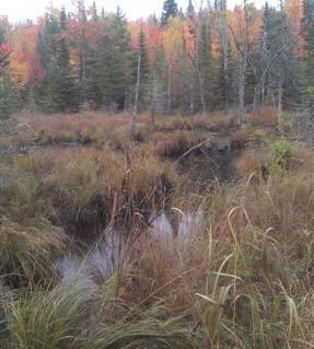
 0.9 8001 8000.5 8000 7999.5 7999 7998.")
 0.4 7999.5 7999 7998.5 7998 7997.")

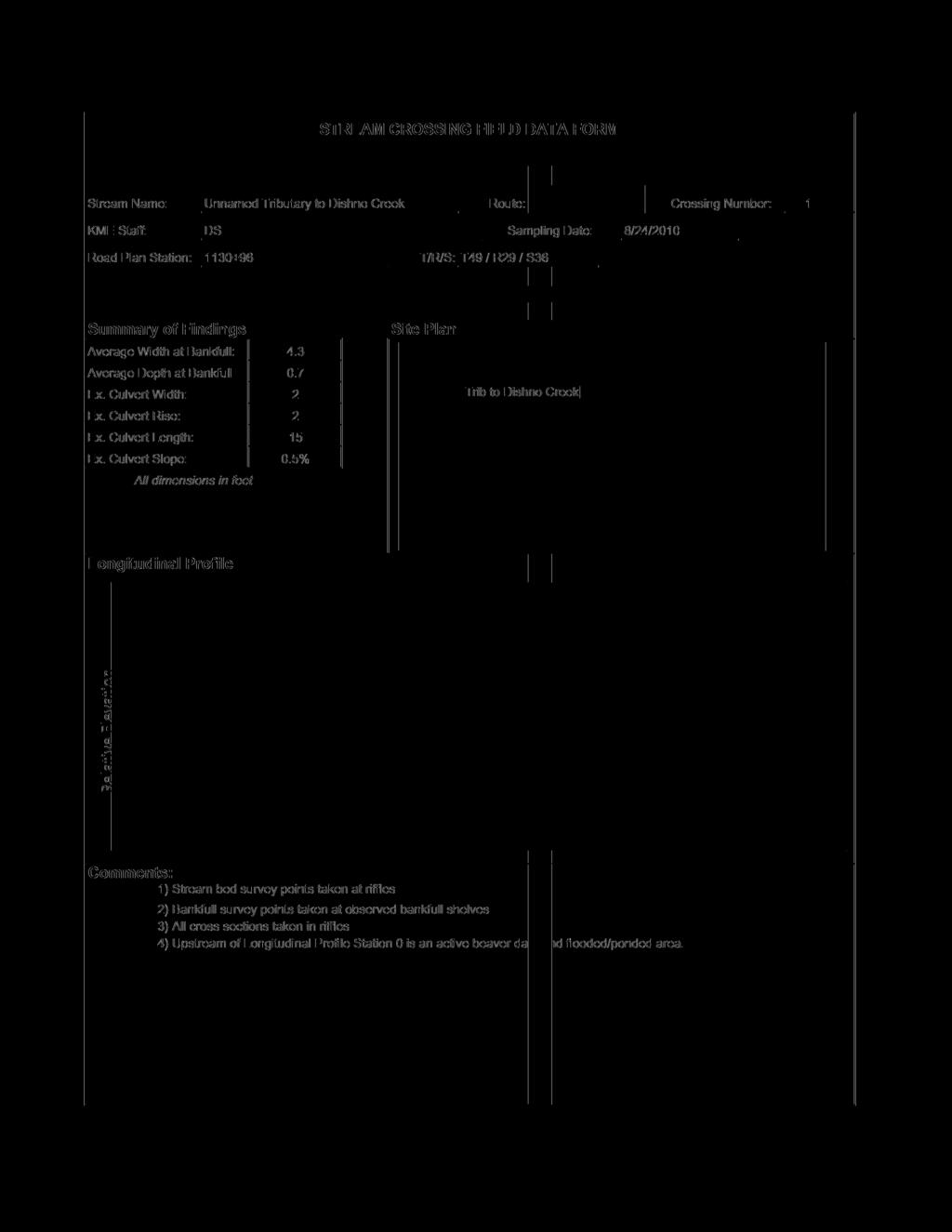
22 Unnamed Tributary to Dishno Creek Cross Sections Cross Section Bankfull Depth (feet) Cross Section Bankfull Depth (feet) Cross Section 3 Bankfull Depth (feet) View downstream of wetland with no decernable stream channel. All Flow is sub-surface Notes: King and MacGregor Environmental, Inc.
23 STREAM CROSSING FIELD DATA FORM Stream Name: KME Staff: Unnamed Tributary to Voelkers Creek Route: CR 595 Crossing Number: 1 DS Sampling Date: 8/23/2010 Road Plan Station: T/R/S: T49 / R29 / S23 Summary of Findings Average Width at Bankfull: Average Depth at Bankfull Ex. Culvert Width: Ex. Culvert Rise: Ex. Culvert Length: Ex. Culvert Slope: All dimensions in feet none none none none Site Plan XS 2 Longitudinal Profile bed water srf bankfull x-section Longitudinal Profile Station Comments: 1) Stream bed survey points taken at riffles 2) Bankfull survey points taken at observed bankfull shelves 3) All cross sections taken in riffles 4) Very low perenninal flow. Appears that flow is from upstream wetland and snow melt.
 0.")


 0.3 9000 8999.")
24 Unnamed Tributary to Voelkers Creek Cross Sections Cross Section Bankfull Depth (feet) Cross Section Bankfull Depth (feet) Width (ft) Cross Section Bankfull Depth (feet) Notes: King and MacGregor Environmental, Inc.
25 STREAM CROSSING FIELD DATA FORM Stream Name: KME Staff: Voelkers Creek Route: CR 595 Crossing Number: 1 MSP Sampling Date: 8/24/2010 Road Plan Station: T/R/S: T49 / R29 / S23 Summary of Findings Average Width at Bankfull: Average Depth at Bankfull Ex. Culvert Width: Ex. Culvert Rise: Ex. Culvert Length: Ex. Culvert Slope: All dimensions in feet % Site Plan Longitudinal Profile bed water srf bankfull x-section Longitudinal Profile Station Comments: 1) Existing culvert from Longitudinal Profile Station 92 to 124 2) Stream bed survey points taken at riffles and pools downstream of existing culvert 3) Bankfull survey points taken at observed bankfull shelves 4) Stream bed survey points taken at centerline of stream channel upstream of culvert 5) All cross sections taken in riffles 6) Channel downstream of culvert is braided; single channel downstream of braided section is influenced by beaver dam 7) Survey point at Longitudinal Profile Station 0 is top of beaver dam
 Bankfull width measured with tape")

 0.7 97 96.5 96 95.5 95 94.")
 0.6 Notes: 97.5 97 96.5 96 95.")
26 Voelkers Creek Cross Sections Cross Section Bankfull Depth (feet) Bankfull width measured with tape only; no cross section surveyed. Section immediately downstream of culvert and may not be outside of road influence. Cross Section Bankfull Depth (feet) Channel 5braided Cross Section Bankfull Depth (feet) 0.6 Notes: Channel braided King and MacGregor Environmental, Inc.
27 STREAM CROSSING FIELD DATA FORM Stream Name: KME Staff: Dead River Route: CR 595 Crossing Number: 1 DS Sampling Date: 8/22/2010 Road Plan Station: T/R/S: T49 / R29 / S11 Summary of Findings Average Width at Bankfull: Average Depth at Bankfull Ex. Culvert Width: Ex. Culvert Rise: Ex. Culvert Length: Ex. Culvert Slope: All dimensions in feet n/a Site Plan Longitudinal Profile Due to deep water conditions created by beaver activity a longitudinal profile was not possilbe. A bridge exists and is proposed for this location. Comments: 1) Cross section taken in riffle


28 Dead River Cross Sections Cross Section 1 n/a 29.4 Bankfull Depth (feet) 2.0 Cross Section 2 n/a Bankfull Depth (feet) 2.2 Width of pool downstream from riffle cross section. Cross Section 3 Bankfull Depth (feet) View upstream of bridge (old beaver pond) Notes: King and MacGregor Environmental, Inc.
29 STREAM CROSSING FIELD DATA FORM Stream Name: KME Staff: Wildcat Canyon Creek Route: CR 595 Crossing Number: 1 DS Sampling Date: 8/24/2010 Road Plan Station: T/R/S: T49 / R29 / S2 Summary of Findings Average Width at Bankfull: Average Depth at Bankfull Ex. Culvert Width: Ex. Culvert Rise: Ex. Culvert Length: Ex. Culvert Slope: All dimensions in feet n/a n/a 2 x % Site Plan Longitudinal Profile Due to the proxminity of upstream and downstream beaver dams a longitudinal profile was not conducted at this location. Comments:
 Twin 36\" CMP")
 Cross")
 Cross Section 3")
30 Wildcat Canyon Creek Cross Sections Cross Section 1 Bankfull Depth (feet) Twin 36" CMP exist. Photograph is looking west (upstream) Cross Section 2 Bankfull Depth (feet) Photograph is looking east (downstream) Cross Section 3 Bankfull Depth (feet) Notes: King and MacGregor Environmental, Inc.

 Due to beaver activity no riffles were present.")
31 STREAM CROSSING FIELD DATA FORM Stream Name: KME Staff: Wildcat Canyon Creek Route: CR 595 Crossing Number: 2 DS Sampling Date: 8/24/2010 Road Plan Station: T/R/S: T49 / R 29 / S2 Summary of Findings Average Width at Bankfull: Average Depth at Bankfull Ex. Culvert Width: Ex. Culvert Rise: Ex. Culvert Length: Ex. Culvert Slope: All dimensions in feet % Site Plan Longitudinal Profile Longitudinal Profile Station Comments: 1) Due to beaver activity no riffles were present. 2) Bankfull survey points taken at observed bankfull shelves


32 Wildcat Canyon Creek No.2 Cross Sections Cross Section Bankfull Depth (feet) 0.9 Cross Section Bankfull Depth (feet) 1.2 Cross Section 3 Bankfull Depth (feet) Notes: King and MacGregor Environmental, Inc.
33 STREAM CROSSING FIELD DATA FORM Stream Name: KME Staff: Wildcat Canyon Creek Route: CR 595 Crossing Number: 3 DS Sampling Date: 8/24/2010 Road Plan Station: T/R/S: T49 / R29 / S2 Summary of Findings Average Width at Bankfull: Average Depth at Bankfull Ex. Culvert Width: Ex. Culvert Rise: Ex. Culvert Length: Ex. Culvert Slope: All dimensions in feet % Site Plan Longitudinal Profile bed water srf bankfull x-section Longitudinal Profile Stationing Comments: 1) Stream bed survey points taken at riffles 2) Bankfull survey points taken at observed bankfull shelves 3) All cross sections taken in riffles
 1.4 11999 11998.5 11998 11997.")
 0.8 11999 11998.5 11998 11997.")
 0.8 Notes: 11998.5 11998 11997.")
34 Wildcat Canyon Creek No. 3 Cross Sections Cross Section Bankfull Depth (feet) Cross Section Bankfull Depth (feet) Cross Section Bankfull Depth (feet) 0.8 Notes: King and MacGregor Environmental, Inc.

35 STREAM CROSSING FIELD DATA FORM Stream Name: KME Staff: Unnamed Tributary to Wildcat Canyon Creek Route: CR 595 Crossing Number: 1 DS Sampling Date: 8/24/2010 Road Plan Station: T/R/S: T49/R29/S2 Summary of Findings Average Width at Bankfull: Average Depth at Bankfull Ex. Culvert Width: Ex. Culvert Rise: Ex. Culvert Length: Ex. Culvert Slope: All dimensions in feet none none none none Site Plan Longitudinal Profile bed water srf bankfull x-section Longitudinal Profile Stationing Comments: 1) Stream bed survey points taken at riffles 2) Bankfull survey points taken at observed bankfull shelves 3) All cross sections taken in riffles
 1.")
 0.")
 0.9 Notes: 12993 12992.")
36 Unnamed Tributary to Wildcat Canyon Creek Cross Sections Cross Section Bankfull Depth (feet) 1.1 Cross Section Bankfull Depth (feet) 0.9 Cross Section Bankfull Depth (feet) 0.9 Notes: King and MacGregor Environmental, Inc.

37 STREAM CROSSING FIELD DATA FORM Stream Name: KME Staff: Unnamed Tributary to Mulligan Creek 1 Route: Woodland Crossing Number: 1 MSP Sampling Date: 8/26/10 Road Plan Station: T/R/S: T50 / R29 / S35 Summary of Findings Average Width at Bankfull: Average Depth at Bankfull Ex. Culvert Width: Ex. Culvert Rise: Ex. Culvert Length: Ex. Culvert Slope: All dimensions in feet , 3 2, 3 31, %, 2% Site Plan Longitudinal Profile bed water srf bankfull x-section Longitudinal Profile Station Comments: 1) Stream bed survey points taken at riffles and steps in step-pool stream segments 2) Bankfull survey points taken at observed bankfull shelves 3) All cross sections taken in riffles 4) Existing culverts from Longitudinal Profile Station 113 to 144 5) Drop downstream of cuverts is bedrock waterfall
 1.4 Cross Section 2 98.")
 1.2 Cross Section 3 310 90 89.5 89 88.")
 1.0 Notes: 87 86.5 86 85.")
38 Unnamed Tributary to Mulligan Creek 1 Cross Sections Cross Section Bankfull Depth (feet) 1.4 Cross Section Bankfull Depth (feet) 1.2 Cross Section Bankfull Depth (feet) 1.0 Notes: King and MacGregor Environmental, Inc.

39 STREAM CROSSING FIELD DATA FORM Stream Name: KME Staff: Unnamed Tributary to Mulligan Creek 2 Route: CR 595 Crossing Number: 1 DS Sampling Date: 8/23/2010 Road Plan Station: T/R/S: T50 / R29 / S35 Summary of Findings Average Width at Bankfull: Average Depth at Bankfull Ex. Culvert Width: Ex. Culvert Rise: Ex. Culvert Length: Ex. Culvert Slope: All dimensions in feet % Site Plan Longitudinal Profile bed water srf bankfull x-section Longitudinal Profile Station Comments: 1) Stream bed survey points taken at riffles 2) Bankfull survey points taken at observed bankfull shelves 3) All cross sections taken in riffles 4) Up stream of existing road is a beaver pond with no stream channel visible. No cross section was surveyed.
 0.")
 0.")
 Notes:")
40 Unnamed Tributary to Mulligan Creek No. 2 Cross Sections Cross Section Bankfull Depth (feet) Cross Section Bankfull Depth (feet) Cross Section 3 Bankfull Depth (feet) Notes: King and MacGregor Environmental, Inc.

41 STREAM CROSSING FIELD DATA FORM Stream Name: KME Staff: Unnamed Tributary to Mulligan Creek 3 Route: CR 595 Crossing Number: 1 MSP Sampling Date: 8/26/2010 Road Plan Station: T/R/S: T50 / R29 / S35 Summary of Findings Average Width at Bankfull: Average Depth at Bankfull Ex. Culvert Width: Ex. Culvert Rise: Ex. Culvert Length: Ex. Culvert Slope: All dimensions in feet Unknown Unknown Site Plan Longitudinal Profile bed water srf bankfull x-section Longitudinal Profile Station Comments: 1) Stream bed survey points taken at center line of wetland upslope of culvert and at steps or riffles down slope of culvert 2) Bankfull survey points taken at observed bankfull shelves 3) Cross section taken in riffle; channel width measurements taken in pool segments of step-pool segments 4) Existing culvert from Longitudinal Profile Station 115 to about 140 5) Existing culvert buried on down slope end
 Upslope of")

 Measured width of pool in")
 0.8 Notes: 14980 14979.")
42 Unnamed Tributary to Mulligan Creek 3 Cross Sections Cross Section 1 75 Bankfull Depth (feet) Upslope of existing road crossing is wetland seeps with no identifiable stream features to survey Cross Section Bankfull Depth (feet) Measured width of pool in step-pool segment Cross Section Bankfull Depth (feet) 0.8 Notes: King and MacGregor Environmental, Inc.

43 STREAM CROSSING FIELD DATA FORM Stream Name: KME Staff: Unnamed Tributary to Mulligan Creek 4 Route: CR 595 Crossing Number: 1 MSP Sampling Date: 8/26/2010 Road Plan Station: T/R/S: T50 / R29 / S26 Summary of Findings Average Width at Bankfull: Average Depth at Bankfull Ex. Culvert Width: Ex. Culvert Rise: Ex. Culvert Length: Ex. Culvert Slope: All dimensions in feet Buried Buried Buried Buried Site Plan Longitudinal Profile bed water srf bankfull x-section Longitudinal Profile Station Comments: 1) Stream bed survey points taken at riffles or steps 2) Bankfull survey points taken at observed bankfull shelves 3) Cross section taken in riffle 4) Identifiable riffle not found upstream of existing Trail 5 crossing 5) Existing Trail 5 crossing from Longitudinal Profile Station 86 to 123

 Cross")
 Cross")
 1")

44 Unnamed Tributary to Mulligan Creek 4 Cross Sections Cross Section Bankfull Depth (feet) Cross Section Bankfull Depth (feet) Cross Section Bankfull Depth (feet) Notes: King and MacGregor Environmental, Inc.
45 STREAM CROSSING FIELD DATA FORM Stream Name: KME Staff: Unnamed Tributary to Mulligan Creek 5 Route: CR 595 Crossing Number: 1 MSP Sampling Date: 8/26/2010 Road Plan Station: T/R/S: T50 / R29 / S26 Summary of Findings Average Width at Bankfull: Average Depth at Bankfull Ex. Culvert Width: Ex. Culvert Rise: Ex. Culvert Length: Ex. Culvert Slope: All dimensions in feet None None None None Site Plan Longitudinal Profile bed water srf bankfull x-section Longitudinal Profile Station Comments: 1) No stream channel observed in area of proposed crossing 2) Profile survey points taken at low point of wetland or swale
 Down slope end of proposed crossing; no swale or standing water")
 Upslope end of proposed crossing; swale")

46 Unnamed Tributary to Mulligan Creek 5 Cross Sections Cross Section Bankfull Depth (feet) Down slope end of proposed crossing; no swale or standing water observed. Cross Section 2 25 Bankfull Depth (feet) Upslope end of proposed crossing; swale with no standing water observed. No stream features observed. Cross Section 3 Bankfull Depth (feet) Upslope of proposed crossing; swale evident with standing water observed. No stream features observed Notes: King and MacGregor Environmental, Inc.

47 STREAM CROSSING FIELD DATA FORM Stream Name: KME Staff: Mulligan Creek Route: CR 595 Crossing Number: 1 MSP Sampling Date: 8/26/2010 Road Plan Station: T/R/S: T50 / R29 / S26 Summary of Findings Average Width at Bankfull: Average Depth at Bankfull Ex. Culvert Width: Ex. Culvert Rise: Ex. Culvert Length: Ex. Culvert Slope: All dimensions in feet None None None None Site Plan d Longitudinal Profile bed water srf bankfull x-section Longitudiinal Profile Station Comments: 1) Stream bed survey points taken at riffles 2) Bankfull survey points taken at observed bankfull shelves 3) All cross sections taken in riffles 4) Proposed road crossing is at approximate Longitudinal Profile Station 52 5) Upstream end of profile is waterfall at beaver dam 6) Downstream end of profile is influenced by backwater from beaver dam


 2.")

48 Mulligan Creek Cross Sections Cross Section Bankfull Depth (feet) 2.1 Note: bankfull width is sum of primary and secondary channels shown in this section and additional south secondary channel Secondary channel from approx. longitudinal profile station 3 to 5 on section is breach of beaver dam. Cross Section Bankfull Depth (feet) Note: bankfull width is sum of channel shown in this section and additional south secondary channel South Secondary Channel Breach of beaver dam has created secondary channel south of primary channel. Measured width of channel is 1.2 feet average Notes: King and MacGregor Environmental, Inc.
49 STREAM CROSSING FIELD DATA FORM Stream Name: KME Staff: Yellow Dog River Route: CR 595 Crossing Number: 1 DS Sampling Date: 8/31/2010 Road Plan Station: T/R/S: T50 / R29 / S13 Summary of Findings Average Width at Bankfull: Average Depth at Bankfull Ex. Culvert Width: Ex. Culvert Rise: Ex. Culvert Length: Ex. Culvert Slope: All dimensions in feet Bridge Bridge Bridge Bridge Site Plan Longitudinal Profile bed water srf bankfull x-section Longitudinal Profile Station Comments: 1) Stream bed survey points taken at riffles 2) Bankfull survey points taken at observed bankfull shelves 3) All cross sections taken in riffles 4) Only one riffle upstream and one riffle down stream were located.
 3.")
 3.")
 Notes: King")
50 Yellow Dog River Cross Sections Cross Section Bankfull Depth (feet) Cross Section Bankfull Depth (feet) Cross Section 3 Bankfull Depth (feet) Notes: King and MacGregor Environmental, Inc.
HEC 26 Aquatic Organism Passage Design Manual Evolution & Application
 HEC 26 Aquatic Organism Passage Design Manual Evolution & Application Sven Leon, P.E., Hydraulics Engineer Federal Highway Administration 2015 Alaska Fish Passage Meeting October 13 14, 2015 VTRC, Juneau,
Culvert Design for Low and High Gradient Streams in the Midwest. Dale Higgins, Hydrologist Chequamegon-Nicolet National Forest
 Culvert Design for Low and High Gradient Streams in the Midwest Dale Higgins, Hydrologist Chequamegon-Nicolet National Forest Overview Culvert Design Considerations Hydraulic Terms Culvert Impacts Low
Aquatic Organism Passage at Road-Stream Crossings CHUCK KEEPORTS FOREST HYDROLOGIST ALLEGHENY NATIONAL FOREST WARREN, PENNSYLVANIA
 Aquatic Organism Passage at Road-Stream Crossings CHUCK KEEPORTS FOREST HYDROLOGIST ALLEGHENY NATIONAL FOREST WARREN, PENNSYLVANIA TOPICS COVERED Aquatic Organism Passage (AOP) Benefits of AOP Crossings
Total Suspended Solids, Stable Flow, and Wet Weather Event Monitoring in the Bass River Watershed. December The Cadmus Group, Inc.
 Total Suspended Solids, Stable Flow, and Wet Weather Event Monitoring in the Bass River Watershed December 2004 The Cadmus Group, Inc. Grand Valley State University Annis Water Resources Institute Submitted
INDIANA REGIONAL GENERAL CONDITIONS FOR THE STATE OF INDIANA
 INDIANA REGIONAL GENERAL CONDITIONS FOR THE STATE OF INDIANA These regional conditions are in addition to but do not supersede the requirements in the Federal Register (Volume 82 No. 4 of January 6, 2017).
STUDY PERFORMANCE REPORT
 STUDY PERFORMANCE REPORT State: Michigan Project No.: F-80-R-4 Study No.: 702 Title: Effects of sediment traps on Michigan river channels Period Covered: October 1, 2002 to September 30, 2003 Study Objectives:
Total Suspended Solids, Stable Flow, and Wet Weather Event Monitoring in the Unnamed Tributary to the Grand River Watershed.
 Total Suspended Solids, Stable Flow, and Wet Weather Event Monitoring in the Unnamed Tributary to the Grand River Watershed December 2004 The Cadmus Group, Inc. Grand Valley State University Annis Water
Interim Guidance Fish Presence Absence
 Interim Guidance Fish Presence Absence Source: Forest Practices Act Guidance for Division 635 of the forest practices act dealing with stream classification when no fish surveys have been done (referenced
Management of headwater streams in the White Mountain National Forest
 Management of headwater streams in the White Mountain National Forest White Mountain National Forest Weeks Act of 1911 authorized the federal government to purchase lands east of the Mississippi River
Minnesota Department of Natural Resources Division of Fish and Wildlife Section of Fisheries. Stream Survey Report. Three Mile Creek 2011
 Minnesota Department of Natural Resources Division of Fish and Wildlife Section of Fisheries Stream Survey Report Three Mile Creek 2011 By Joseph D. Stewig Montrose Area Fisheries Office TABLE OF CONTENTS
Fish Passage Culvert Assessment for Cahilty Creek Watershed FIA Project #
 Fish Passage Culvert Assessment for Cahilty Creek Watershed FIA Project # 4602004 Prepared for Weyerhaeuser Company Ltd. Jason Ladyman R.P.F. 1550 Mission Flats Road PO Box 40 Kamloops BC V2C 5K3 Prepared
Eastern Brook Trout Joint Venture Annual Report The Nature Conservancy 2013
 Eastern Brook Trout Joint Venture Annual Report The Nature Conservancy 2013 2013 Annual Performance Report Enhancing Connectivity in the Ash-Black Rock Sub-basin of the West Branch Narraguagus River. Project
Kasaan to Goose Creek Road Project Project Description U.S. Army Corps of Engineers Permit The following table presents the mile point of the culverte
 Kasaan to Goose Creek Road Project Project Description U.S. Army Corps of Engineers Permit The following table presents the mile point of the culverted open water crossings, name of water crossing if known,
Geomorphic Stream Classification A Classification of Natural Rivers, Rosgen, D.L.
 Geomorphic Stream Classification A Classification of Natural Rivers, Rosgen, D.L. Why is Stream Classification Physical stream channel evolution Essential? Similar stream types manifest similar patterns
Public Notice. Corps File No. LRE Date: March 19, 2017 Expires: March 18, 2022
 US Army Corps of Engineers Detroit District Public Notice Corps File No. LRE-2016-00006-100 Date: March 19, 2017 Expires: March 18, 2022 PUBLIC NOTICE ANNOUNCING REGIONAL CONDITIONS AND WATER QUALITY CERTIFICATIONS
Added Introduction: Comparing highway design and stream design
 Added Introduction: Comparing highway design and stream design Highway width is sized for the traffic, the width expanding as volume and speed increase. The ROW width is also designed to handle the speed
Washington State Fish Passage Barrier Removal Projects. Casey Kramer, PE WSDOT State Hydraulics Engineer
 Washington State Fish Passage Barrier Removal Projects Casey Kramer, PE WSDOT State Hydraulics Engineer 2014 National Hydraulic Engineering Conference Iowa City, IA August 20 th, 2014 WSDOT Fish Passage
Habitat Conditions, Design Strategies,
 Habitat Conditions, Design Strategies, Coho on Cedar Ck. five years after analog-based stream restoration work. and Stream Classification In river work, computer modeling is an insidious procedure in which
Illinois State Water Survey
 Illinois State Water Survey HYDROLOGY DIVISION SWS Contract Report 508 COMPARISON OF 1987 AND 1989 BED PROFILE SURVEYS OF THE LOWER CACHE RIVER by Richard Allgire Office of Sediment and Wetland Studies
Biological Survey of Allagash Stream
 F i"shery Interim Summary Report Series No. 07-04 Biological Survey of Allagash Stream By Forrest R. Bonney Caring for Maine's Outdoor Future September, 2007 Maine Department of Inland Fisheries and Wildlife
Simulating Streams Through Culverts in Mat-Su, Alaska
 Simulating Streams Through Culverts in Mat-Su, Alaska Project Managers Bill Rice, P.E., USFWS Hydrologist Mary Price, USFWS Fishery Biologist The Team Approach US Fish and Wildlife Service Bill Rice, P.E.,
Tahquamenon River Assessment
 State owned land USFS land Superior Lower Falls USGS Gauging Station Superior Tahquamenon s Belle s Slater s Bass Betty B Dollarville Flooding Eckerman McMillan Mud East Kaks Twin McPhee s Hulbert Hulbert
Job 1. Title: Estimate abundance of juvenile trout and salmon.
 STUDY PERFORMANCE REPORT State: Michigan Project No.: F-53-R-13 Study No.: 461 Title: Population dynamics of juvenile rainbow trout and coho salmon in Lake Superior tributaries Period Covered: April 1,
Joe Rathbun Michigan DEQ Water Resources Division Nonpoint Source Unit * Thanks to The Nature Conservancy
 Joe Rathbun Michigan DEQ Water Resources Division Nonpoint Source Unit rathbunj@mi.gov * Thanks to The Nature Conservancy Road-stream intersections = 67,511 Culverts = 60,700 Bridges = 6,811 Perched Piping
STREAM SURVEY File form No..
 scanned for KRIS THE RESOURCES AGENCY OF CALIFORNIA California Department of Fish and Game STREAM SURVEY File form No.. Date: September 4, 1969. NAME: North Fork Schooner Gulch Creek COUNTY: Mendocino.
Michigan Department of Natural Resources Status of the Fishery Resource Report Page 1
 Michigan Department of Natural Resources 2008-59 Status of the Fishery Resource Report Page 1 Bowens Manistee County, (T24N R16W Sec. 11, 12, 13, 14, 15, 24, and 30). Last surveyed 2008 Mark A. Tonello
E-3: Jurisdictional Determination Supplement Report
 Lake Ralph Hall Appendix E E-3: Jurisdictional Determination Supplement Report P.O. Drawer 305 Lewisville, TX 75067 REGIONAL WATER DISTRICT (972)219-1228 Fax(972)221-9896 June 22, 2017 Mr. Chandler Peter
APPENDIX J HYDROLOGY AND WATER QUALITY
 APPENDIX J HYDROLOGY AND WATER QUALITY J-1 Technical Report on Airport Drainage, Northern Sector Airport and Ordinance Creek Watershed / Preliminary Creek Constructed Natural Channel Culvert J-2 Preliminary
Quantifying Performance of Stream Simulation Culverts in the Chehalis Basin, WA
 Quantifying Performance of Stream Simulation Culverts in the Chehalis Basin, WA AUTHORS: Joe Richards, Environmental Science Associates Jane Atha, Washington Department of Fish & Wildlife Colin Thorne,
Understanding the Impacts of Culvert Performance on Stream Health
 Understanding the Impacts of Culvert Performance on Stream Health Kristin Thomas Aquatic Ecologist Michigan Trout Unlimited Transportation and the Environment Conference 12/5/2018 Importance of adequately
4.4 ASSESSMENT OF POTENTIAL ANADROMOUS FISH HABITAT UPSTREAM OF MERWIN DAM (AQU 4)
") 4.4 ASSESSMENT OF POTENTIAL ANADROMOUS FISH HABITAT UPSTREAM OF MERWIN DAM (AQU 4) 4.4.1 Study Objectives The objectives of this study are to: (1) delineate the stream segments in the upper North Fork
4.4 ASSESSMENT OF POTENTIAL ANADROMOUS FISH HABITAT UPSTREAM OF MERWIN DAM (AQU 4) 4.4.1 Study Objectives The objectives of this study are to: (1) delineate the stream segments in the upper North Fork
Minnesota Department of Natural Resources Division of Fish and Wildlife Section of Fisheries. Stream Survey Report. Luxemburg Creek.
 Minnesota F-29-R(P)-24 Area 315 Study 3 March 2016 Minnesota Department of Natural Resources Division of Fish and Wildlife Section of Fisheries Stream Survey Report Luxemburg Creek 2015 Mark Pelham Sauk
Presented by Fred Halterman, URS Jennie Agerton, URS
 Presented by Fred Halterman, URS Jennie Agerton, URS What is Eco Friendly Culvert Design? Culvert design that: Maintains connectivity for aquatic organism migration Maintains connectivity for gene flow
DRAFT. Stonybrook Creek Watershed
 DRAFT Stonybrook Creek Watershed A Strategic Plan for Eliminating Barriers to Steelhead Migration June 4, 2010 Prepared by: PO Box 4477, Arcata, CA 95518 mlove@h2odesigns.com / (707) 476 8938 Prepared
Little Traverse Bay Watershed Road/Stream Crossing Inventory
 Little Traverse Bay Watershed Road/Stream Crossing Inventory Completed by Tip of the Mitt Watershed Council with support from: Petoskey-Harbor Springs Area Community Foundation s Little Traverse Bay Protection
TOP:001.3 U.S. Fish and Wildlife Service TECHNICAL OPERATING PROCEDURE
 TOP:001.3 March 12, 2015 U.S. Fish and Wildlife Service Marquette Biological Station 3090 Wright Street Marquette, Michigan 49855 U.S.A. and U.S. Fish and Wildlife Service Ludington Biological Station
Stream Assessment Cut-block: For: Island Timberlands Limited Partnership, Cameron Operation
 Stream Assessment Cut-block: 171214 For: Island Timberlands Limited Partnership, Cameron Operation Tony Norris Area Engineer Island Timberlands Cameron Operation Port Alberni D.G. Rigets E.I.A. CTech.
Climate Change Adaptation and Stream Restoration. Jack Williams;
 Climate Change Adaptation and Stream Restoration Jack Williams; jwilliams@tu.org 1 Goals for this presentation Develop strategies for adapting streams to climate impacts by Thinking like a watershed Understanding
Massachusetts Stream Crossing Case Studies
 Massachusetts Stream Crossing Case Studies Amy Singler Associate Director, River Restoration Program Carrie Banks River Continuity Coordinator Case Studies: Public Benefits: Movement of goods and people
Hydraulic Modeling of Stream Enhancement Methods
 Hydraulic Modeling of Stream Enhancement Methods Matthew J. Curry John J. Levitsky Abstract Development within watersheds increases the amounts of runoff causing stream erosion and degradation of stream
Level II Stream Survey for the Timberline Express Proposal
 TECHNICAL MEMORANDUM 24 146th Place SE Suite 6 Bellevue WA 987 Tel: 42.6.69 Fax: 42.6.694 www.segrp.com TO: FROM: CC: Bill Granger Travis Spikes Timberline Express EIS project folder DATE: October 21,
Project Completion Abstract Fish Passage Activity ( Engineering Activities)
") Project Completion Abstract Fish Passage Activity ( Engineering Activities) SUBMIT COMPLETED FORM TO DISTRICT MANAGER AND FIA ADMINISTRATOR AFTER PROJECT COMPLETION SECTION A GENERAL INFORMATION Recipient:
Project Completion Abstract Fish Passage Activity ( Engineering Activities) SUBMIT COMPLETED FORM TO DISTRICT MANAGER AND FIA ADMINISTRATOR AFTER PROJECT COMPLETION SECTION A GENERAL INFORMATION Recipient:
Packwood Hydroelectric Project Barrier Analysis December 12, 2006
 Packwood Hydroelectric Project Barrier Analysis December 12, 2006 Study Area Natural barriers to upstream fish passage on Lake Creek at RM 1.03 and RM 1.95 Snyder Creek culvert under the Project tailrace
HYDROLOGIC AND HYDRAULIC REPORT PROPOSED CULVERT STRUCTURES SR 194, SECTION 10
 HYDROLOGIC AND HYDRAULIC REPORT PROPOSED CULVERT STRUCTURES SR 194, SECTION 10 RACETRACK ROAD CULVERT OVER THE SPRING RUN & GREEN SPRINGS ROAD CULVERT OVER AN UNNAMED TRIBUTARY TO SPRING RUN BERWICK TOWNSHIP
Great Lakes Stream Crossing Inventory Instructions
 Great Lakes Stream Crossing Inventory Instructions This document is a guide to completing the Stream Crossing Data Sheet (2/28/11 version). Careful attention to this guidance will ensure consistent crossing
CALIFORNIA SALMONID STREAM HABITAT RESTORATION MANUAL APPENDIX IX-A CULVERT CRITERIA FOR FISH PASSAGE INTRODUCTION
 APPENDIX IX-A STATE OF CALIFORNIA RESOURCES AGENCY DEPARTMENT OF FISH AND GAME CULVERT CRITERIA FOR FISH PASSAGE For habitat protection, ecological connectivity should be a goal of stream-road crossing
REC 6 FISHERIES HABITAT EVALUATION
 REC 6 FISHERIES HABITAT EVALUATION 1.0 EXECUTIVE SUMMARY Analysis of fisheries habitat for recreational angling opportunities was completed by reviewing the results of the CAWG 1, Characterize Stream and
Fish Habitat Restoration and Monitoring in Southeast Washington. Andy Hill Eco Logical Research, Inc.
 Fish Habitat Restoration and Monitoring in Southeast Washington Andy Hill Eco Logical Research, Inc. Fish Habitat Restoration and Monitoring in Southeast Washington Talk overview: Restoration projects
Gaviota Creek Fish Passage and Geomorphic Assessment
 Gaviota Creek Fish Passage and Geomorphic Assessment Prepared for California Department of Fish and Game And Pacific States Marine Fisheries Commission Prepared by Michael Love and Associates PO Box 4477
FISH PASSAGE ALTERNATIVES ANALYSIS ON PENNYPACK CREEK AT VERREE ROAD DAM AND ROOSEVELT BOULEVARD DAM PHILADELPHIA, PENNSYLVANIA
 FISH PASSAGE ALTERNATIVES ANALYSIS ON PENNYPACK CREEK AT VERREE ROAD DAM AND ROOSEVELT BOULEVARD DAM PHILADELPHIA, PENNSYLVANIA Prepared for: One Parkway, 10 th Floor 1515 Arch Street Philadelphia, PA
TROUT CREEK WATERSHED (Second Year of Snowline Data)
") Extent of Snow Cover During the 2002 Spring Freshet For the TROUT CREEK WATERSHED (Second Year of Snowline Data) (Penticton Forest District) 1.0 INTRODUCTION The extent of snow cover over a watershed basin
Extent of Snow Cover During the 2002 Spring Freshet For the TROUT CREEK WATERSHED (Second Year of Snowline Data) (Penticton Forest District) 1.0 INTRODUCTION The extent of snow cover over a watershed basin
Study Update Fish Distribution and Species Composition
 Study Update Fish Distribution and Species Composition Goals and Study Area Gain a better understanding of fish species composition and abundance in waters associated with the Packwood Lake Hydroelectric
Summer Steelhead Surveys North Fork Trinity River Trinity County, California
 KRIS edition Summer Steelhead Surveys North Fork Trinity River Trinity County, California 1978-1997 By Loren Everest Fishery Biologist Weaverville Ranger District Shasta-Trinity National Forests October
Detailed Model Simulation Results for Proposed Situation
 APPENDIX C Detailed Model Simulation Results for Proposed Situation Status Issue 2 Page 89 January 2013 Figure C-1 to C-15 complement the tabulated peak flood level and discharge predictions in Tables
OFFICE OF STRUCTURES MANUAL FOR HYDROLOGIC AND HYDRAULIC DESIGN CHAPTER 13 CULVERTS APRIL 2011
 OFFICE OF STRUCTURES MANUAL FOR HYDROLOGIC AND HYDRAULIC DESIGN CHAPTER 13 CULVERTS APRIL 2011 APRIL 2011 Chapter 13 Culverts Table of Contents Foreword.3 13.1 Introduction.. 4 13.2 Policy 6 13.3 Passage
Culvert Design An Overview of the NYS Highway Design Manual Chapter 8
 Seventeenth Statewide Conference on Local Bridges Culvert Design An Overview of the NYS Highway Design Manual Chapter 8 Tuesday, October 25, 2011 Training Session: Culvert Design, Analysis - talk 2 Presented
Fish Passage at Road Crossings Assessment Boise National Forest FY 2004
 Culvert Inventory Summary 2004 - Boise National Forest Fish Passage at Road Crossings Assessment Boise National Forest FY 2004 Feather River at Road #135 Crossing By Michael S. Kellett, Fishery Biologist
SELBY CREEK SILVERADO TRAIL CULVERT FISH PASSAGE ASSESSMENT
 SELBY CREEK SILVERADO TRAIL CULVERT FISH PASSAGE ASSESSMENT NAPA COUNTY, CALIFORNIA PREPARED BY NAPA COUNTY RESOURCE CONSERVATION DISTRICT 1303 JEFFERSON ST. SUITE 500B NAPA, CALIFORNIA 94559 WWW.NAPARCD.ORG
3. The qualification raised by the ISRP is addressed in #2 above and in the work area submittal and review by the ISRP as addressed in #1.
 Please find attached a response from The Confederated Tribes of the Warm Springs Reservation of Oregon (CTWSRO) for Project # 2008-301-00, Habitat Restoration Planning, Design and Implementation within
LONGITUDINAL FIELD METHODOLOGY FOR THE ASSESSMENT OF TMDL SEDIMENT AND HABITAT IMPAIRMENTS
 LONGITUDINAL FIELD METHODOLOGY FOR THE ASSESSMENT OF TMDL SEDIMENT AND HABITAT IMPAIRMENTS Montana Department of Environmental Quality 1520 East Sixth Avenue Helena, Montana 59620 June 2007 TABLE OF CONTENTS
TABLE 1. Riverscape surveys completed in the upper Chehalis River, Newaukum, and Satsop rivers.
 RIVERSCAPE SURVEYS OF IN-STREAM FISH ASSEMBLAGES AND HABITAT IN THE CHEHALIS RIVER Mara Zimmerman and John Winkowski Washington Department of Fish and Wildlife, Fish Program EXECUTIVE SUMMARY Introduction
Overview of temperature protocols
 Overview of temperature protocols 10:55-11:10 Water temperature - Jen Stamp (Tt), Aaron Moore (VT DEC) 11:10-11:25 Air temperature - Zack Holden (USFS) Water Resources Research Center Workshop: Continuous
Report prepared for: Prepared by: January 2002 BEAK Ref
 AQUATIC ENVIRONMENTAL STUDY KANATA WEST CONCEPT PLAN Report prepared for: ROBINSON CONSULTANTS Prepared by: BEAK INTERNATIONAL INCORPORATED 14 Abacus Road Brampton, Ontario L6T 5B7 January 2002 BEAK Ref.
Annex E Bridge Pier Protection Plan
 Annex E Bridge Pier Protection Plan Table E1 Bridge Types and Locations Table E2 Flow Conditions For River Sections Figure E1 Bridge Abutment Protection Figure E2 Bridge Pier Protection Figure E3 Central
FSOC Upstream Fish Passage Guidance Document
 FSOC Upstream Fish Passage Guidance Document STEP 1: Identify species and life stages in need of fish passage STEP 2: Identify fishway options and species applicability STEP 3 Fish passage criteria review
Conserving the Forests, Lakes and Streams of Northeast Michigan
 4241 Old US 27 South, Suite 2, Gaylord, Michigan 49735 (989) 448-2293 www.huronpines.org info@huronpines.org Prioritized Restoration Projects in the AuSable River Watershed Summer 2015 Update from Huron
FINAL REPORT. Yonkers Creek Migration Barrier Removal Project Wonderstump Road Del Norte County. Submitted By:
 FINAL REPORT Yonkers Creek Migration Barrier Removal Project Wonderstump Road Del Norte County Submitted By: Del Norte County Community Development Department Yonkers Creek Migration Barrier Removal Project
Proposed Reclassification of Muskrat Creek, North Platte River Basin in Goshen County, Wyoming
 Proposed Reclassification of Muskrat Creek, North Platte River Basin in Goshen County, Wyoming October 25, 2010 Waterbody: Muskrat Creek - Mainstem of Muskrat Creek from its headwaters downstream to its
Chinook Salmon Spawning Study Russian River Fall 2005
 Chinook Salmon Spawning Study Russian River Fall 2005 Sonoma County Water Agency 2150 West College Avenue Santa Rosa, California 95401 Prepared by David Cook - Senior Environmental Specialist March 27,
Big Spring Creek Habitat Enhancement and Fishery Management Plans
 Big Spring Creek Habitat Enhancement and Fishery Management Plans November 5, 2012 Big Spring Events and Activities Center Newville, PA Charlie McGarrell Regional Habitat Biologist Pennsylvania Fish and
Fish Passage Assessment of Private Stream Crossings on Lower Stonybrook Creek
 Fish Passage Assessment of Private Stream Crossings on Lower Stonybrook Creek Prepared by: Michael Love & Associates In cooperation with: Center for Ecosystem Management and Restoration Funded by: Coastal
Newaukum Watershed Culvert Assessment
 Newaukum Watershed Culvert Assessment Water Resource Inventory Area 23 Lewis County Conservation District Final Report By: Kelly Verd and Nikki Wilson July 2002 Funded by: Chehalis Fisheries Restoration
Ontonagon River Assessment
 Urban/Industrial.1% Open water 4.5% Wetland 15.% Barren.6% Agriculture 5.4% Grassland.2% Forest 74.2% Figure 19. Percent land use in the Ontonagon River watershed. Michigan data from Michigan 1992 NLCD
Plan B Dam Breach Assessment
 Plan B Dam Breach Assessment Introduction In support of the Local Sponsor permit applications to the states of Minnesota and North Dakota, a dam breach analysis for the Plan B alignment of the Fargo-Moorhead
APPENDIX C ESTIMATING SCOUR IN BOTTOMLESS ARCH CULVERTS
 OFFICE OF STRUCTURES MANUAL FOR HYDROLOGIC AND HYDRAULIC DESIGN CHAPTER 11, EVALUATING SCOUR AT BRIDGES APPENDIX C ESTIMATING SCOUR IN BOTTOMLESS ARCH CULVERTS APRIL 2011 APPENDIX C ESTIMATING SCOUR IN
Minnesota Department of Natural Resources Division of Fish and Wildlife Section of Fisheries. Stream Survey Report. Cold Spring Creek.
 Minnesota F-29-R(P)-24 Area 315 Study 3 March 2015 Minnesota Department of Natural Resources Division of Fish and Wildlife Section of Fisheries Stream Survey Report Cold Spring Creek 2014 Mark Pelham Montrose
Susitna-Watana Hydroelectric Project (FERC No )
") (FERC No. 14241) Study of Fish Passage Barriers in the Middle and Upper Susitna River and Susitna Tributaries Study Plan Section 9.12 Final Study Plan July 2013 9.12. Study of Fish Passage Barriers in
(FERC No. 14241) Study of Fish Passage Barriers in the Middle and Upper Susitna River and Susitna Tributaries Study Plan Section 9.12 Final Study Plan July 2013 9.12. Study of Fish Passage Barriers in
Salmon Run G.C. Hole 3: Tributary & Wetland Restoration
 Salmon Run G.C. Hole 3: Tributary & Wetland Restoration Preliminary Project Design December 23, 2014 Prepared By: Curry Soil and Water Conservation District & Swanson Ecological Services, LLC Project Location:
Hydrologic, Hydraulic and Geomorphic Technical Memorandum
 Appendix A Hydrologic, Hydraulic and Geomorphic Technical Memorandum 01054/8410233/14/Rohner_Alt_Analysis_Report Rohner Creek Flood Control, Habitat and Seismic Improvement Project Alternatives Analysis
Design Report for Janes Creek Roughened Channel
 August 12, 2005 Design Report for Janes Creek Roughened Channel Table of Contents Project Description...1 Overview of Report...1 Background...2 Design Flows...3 Roughened Channel Design...6 Fish Passage
BC Ministry of Forests. March Fish Stream Crossing Guidebook. Forest Practices Code of British Columbia.
 FRST 557 Lecture 7c Bridges and Culverts: Water Velocity and Discharge Lesson Background and Overview: The previous two lessons presented methods for estimating water volume flow at a particular site and
Stream Assessment. Date. Data Collected by. Location. Name of Stream and River Basin. Stream Order. Streambank Materials. Streambank Vegetation
 Stream Assessment Date Data Collected by Location Name of Stream and River Basin Stream Order Streambank Materials Streambank Vegetation Floodplain Soils Floodplain Vegetation Valley Type Valley Constraints
Northwest Michigan Stream Connectivity
 Northwest Michigan Stream Connectivity Restoring Aquatic Ecosystems in the Upper Great Lakes CONSERVATION RESOURCE ALLIANCE Beaver Island 5 3 Iron Ore Creek Maple River Cheboygan Black River Petoskey Charlevoix
INTERNATIONAL JOURNAL OF CIVIL AND STRUCTURAL ENGINEERING Volume 5, No 2, 2014
 INTERNATIONAL JOURNAL OF CIVIL AND STRUCTURAL ENGINEERING Volume 5, No 2, 2014 Copyright by the authors - Licensee IPA- Under Creative Commons license 3.0 Research article ISSN 0976 4399 Modification of
(Revised February,2005) CULVERTS, BRIDGES, AND FORDS
 CULVERTS, BRIDGES, AND FORDS") GUIDE TO STREAM CROSSINGS (Revised February,2005) CULVERTS, BRIDGES, AND FORDS Culverts, bridges, and fords are all methods used to cross-streams. Culverts are the most common stream crossing structure.
GUIDE TO STREAM CROSSINGS (Revised February,2005) CULVERTS, BRIDGES, AND FORDS Culverts, bridges, and fords are all methods used to cross-streams. Culverts are the most common stream crossing structure.
APPENDIX D: North Fork Nooksack Sub-basin Report
 APPENDIX D: North Fork Nooksack Sub-basin Report WHATCOM COUNTY FISH PASSAGE ASSESSMENT SUBBASIN REPORT NORTH FORK NOOKSACK RIVER Description of Sub-basin The North Fork Nooksack River originates at an
Juvenile Steelhead and Stream Habitat Conditions Steelhead and Coho Salmon Life History Prepared by: DW ALLEY & Associates, Fishery Consultant
 Juvenile Steelhead and Stream Habitat Conditions Steelhead and Coho Salmon Life History Prepared by: DW ALLEY & Associates, Fishery Consultant I-1. Steelhead and Coho Salmon Ecology Migration. Adult steelhead
Youngs Creek Hydroelectric Project (FERC No. P 10359)
") Youngs Creek Hydroelectric Project (FERC No. P 10359) Resident Trout Monitoring Plan Annual Report 2010 Survey and Results of Pre Project Monitoring Prepared by: September 2010 Overview The Public Utility
Youngs Creek Hydroelectric Project (FERC No. P 10359) Resident Trout Monitoring Plan Annual Report 2010 Survey and Results of Pre Project Monitoring Prepared by: September 2010 Overview The Public Utility
Thunder Bay River Assessment
 Au Sable River near Red Oak Ontonagon River Near Rockland Mainstem Thunder Bay River below Four Mile Dam (near Alpena) St. Joseph River at Three Rivers Grand River at Lansing 0.0 0.1 0.2 0.3 0.4 0.5 0.6
Klickitat County Shoreline Master Program Update. Open House March 15, 2017
 Klickitat County Shoreline Master Program Update Open House March 15, 2017 Agenda 6:00 6:10 Welcome 6:10 6:40 Presentation SMP Update Process Shoreline Analysis review 6:40 8:00 Open House Topics SMP Process
Technical Report Culvert A Hydraulic Analysis
 DATE: November 3, 2011 Technical Report Culvert A Hydraulic Analysis TO: FROM: RE: Jim Reiser, P.E. Project Manager Parsons Brinckerhoff, Inc. Kurt Killian, P.E., CFM Parsons Brinckerhoff, Inc. Design
Trout Unlimited Comments on the Scope of Environmental Impact Statement for the Constitution Pipeline Project, Docket No. PF12-9
 October 9, 2012 Kimberly D. Bose, Secretary Federal Energy Regulatory Commission 888 First Street, NE, Room 1A Washington, DC 20426 RE: Trout Unlimited Comments on the Scope of Environmental Impact Statement
Assessing Ecosystem Impacts from Road Stream Crossings through Community Involvement
 Assessing Ecosystem Impacts from Road Stream Crossings through Community Involvement Background Why is the NH Fish and Game Department interested in culverts? Block fish migration Reduce opportunities
Sub-watershed Summaries
 Project Description The Salmon Drift Creek Watershed Council (SDCWC) has focused their efforts in the Salmon River estuary for the past few years. The multifaceted partnership effort is nearing completion
Fish Passage Assessment Report Mare Brook Culverts
 Fish Passage Assessment Report Mare Brook Culverts Fish Passage Assessment Component of Mare Brook Watershed Assessment and Community Engagement Project Prepared for: FB Environmental Associates 97A Exchange
PENNDRAIN.rep. HEC-RAS Version May 2005 U.S. Army Corp of Engineers Hydrologic Engineering Center 609 Second Street Davis, California
 HEC-RAS Version 3.1.3 May 2005 U.S. Army Corp of Engineers Hydrologic Engineering Center 609 Second Street Davis, California X X XXXXXX XXXX XXXX XX XXXX X X X X X X X X X X X X X X X X X X X XXXXXXX XXXX
Proposed Reclassification of Cherry Creek, North Platte River Basin, Wyoming. October 25, 2010
 Proposed Reclassification of Cherry Creek, North Platte River Basin, Wyoming October 25, 2010 Waterbody: Location: Tributary to: Cherry Creek - Mainstem from headwaters downstream to the confluence with
Stormwater Management Pond Design Brief. Greely Village Centre - Commercial Phase - Ultimate Conditions - - City of Ottawa -
 Stormwater Management Pond Design Brief Greely Village Centre - Commercial Phase - Ultimate Conditions - - City of Ottawa - December 2008 Ref: 647-07 J.F. Sabourin and Associates Inc. Water Resources and
Suitable Applications Check dams may be appropriate in the following situations: To promote sedimentation behind the dam.
 Categories EC Erosion Control SE Sediment Control TC Tracking Control WE Wind Erosion Control Non-Stormwater NS Management Control Waste Management and WM Materials Pollution Control Legend: Primary Category
TECHNICAL MEMORANDUM 002 EMORANNO. 001
 TECHNICAL MEMORANDUM 002 EMORANNO. 001 To: Jack Synder, P.E. EES Consulting From: Mort McMillen, P.E. Paul Larson, SE Date: October 13, 2010 Project: Cc: Taylor Bowen Subject: Technical Memorandum (TM)