Virginia Save Our Streams. A biological assessment of stream quality
|
|
|
- Emory Harvey
- 6 years ago
- Views:
Transcription


1 Virginia Save Our Streams A biological assessment of stream quality
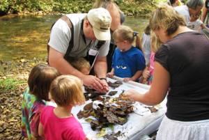
2 SML Save Our Streams Program Collaborative effort: Virginia Save Our Streams (SOS) - Upper Roanoke River Watershed Smith Mountain Lake Association Virginia Master Naturalist - Blue Ridge Foothills & Lakes Chapter
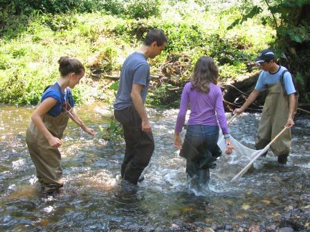
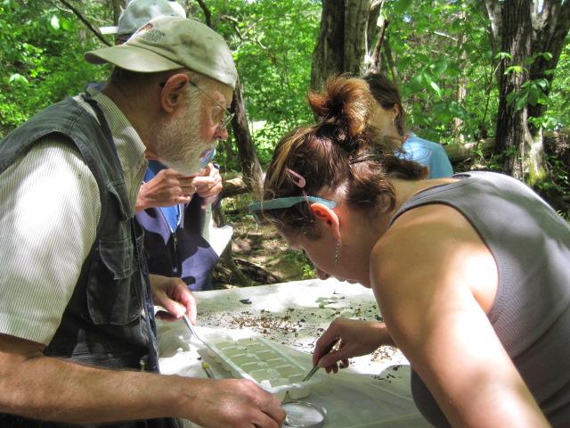
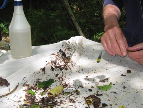
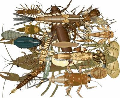
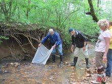
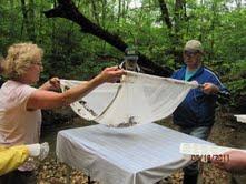
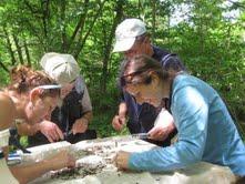
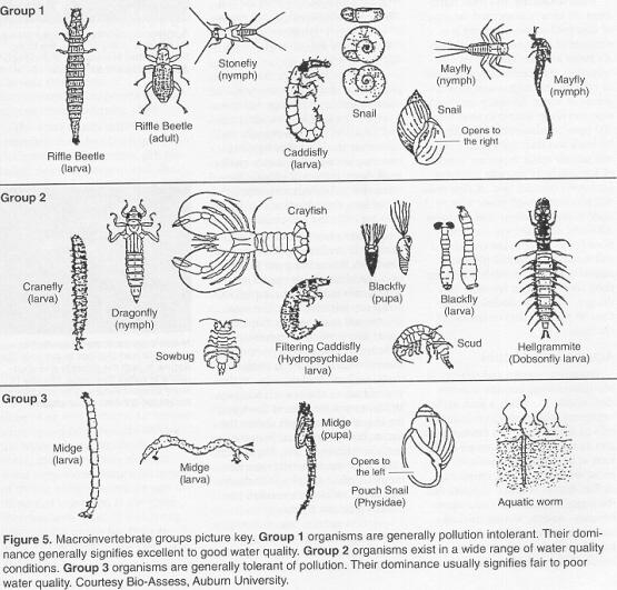
3 Virginia SOS Protocol Volunteer monitors count and identify benthic macroinvertebrates living in riffles on quarterly basis Does not include doing bacterial counts Data entered into VA. SOS database Maintained by Izaak Walton League of America Statewide data annually submitted to VA DEQ
4
5
6 SOS Monitors Around SML 3 certified trainers 32 certified monitors - Over 820 volunteer hours in individuals in active training Monitor 19 sites around SML - 9 are near WQM dip bucket Sites
7 Franklin County Blackwater River (2 sites) Foul Ground Creek Gills Creek (3 sites) Grimes Creek Indian Creek Indian Run Jack O Lantern Creek Lynville Creek Maggodee Creek (2 sites) Poplar Camp Creek Pigg River (3 sites) Bedford County South Fork Hickory Creek Stoney Creek, Beechwood West 19 Stream Sites Monitored
8 SOS Local Trend Data Metric values from each monitoring session used to develop an overall yearly score for each site Formula developed by Dr. Reese Voshell at Virginia Tech. Scoring system: 0 7 = unacceptable ecological conditions 8 = gray zone ecological conditions cannot be determined 9 12 = acceptable ecological conditions
9 Gills Creek Area Notes Jack O Lantern BOWA In Booker T. Washington National Park Impacted in by Westlake development Gills Creek BOWA In Booker T. Washington National Park Gills Creek Liberty Hall Off Liberty Hall Road and bridge crossing Rt. 122 Gills Creek North Fork Windy Gap area off Truman Road
10 Save Our Streams Summary Data Gills Creek Area Score Year Jack O'Lantern - BOWA Gills Creek - BOWA Gills Creek - Liberty Hall Gills Creek - North Fork NOTE: 2013 partial data only
11 Blackwater Area Notes Blackwater Riverbend End of Riverbend community off Rt. 220 in Rocky Mount Blackwater Dillon s Mill Dugspur Road, Callaway Foul Ground Creek Webster Road near Crafts Church Road, Glade Hill Poplar Camp Creek Ayers Road, Glade Hill
12 Save Our Streams Summary Data Blackwater Area Score Year Blackwater - Riverbend Blackwater - Dillon's Mill Foul Ground Creek Poplar Camp Creek NOTE: 2013 partial data only
13 Hardy Road Area Notes Indian Run Hardy Road 1 mile up from Booker T. Washington Highway Grimes Creek Wooded Acres development Lynville Creek North and west of clear cut area on Hardy Road Indian Creek Westlake Golf Course
14 Score Save Our Streams Summary Hardy Road Area Year Indian Run Grimes Creek Lynville Creek Indian Creek NOTE: 2013 partial data only
15 Boones Mill Area Notes Maggodee Creek Rt. 220 North of town Maggodee Creek Boones Mill Road Near bridge on Boones Mill Road
16 Score Save Our Streams Summary Data Boones Mill Area Year Maggodee Creek - Rt. 220 Maggodee Creek - Boones Mill Rd. NOTE: 2013 partial data only
17 Pigg River Area Notes Pigg River Waid Park, Rocky Mount Near parking lot and bridge Pigg River Big Branch Near Redwood Pigg River Cooper s Mill Bridge Glade Hill/Colonial Turnpike area
18 Score Save Our Streams Summary Pigg River Year Pigg River - Waid Park Pigg River - Big Branch Pigg River - Cooper's Mill Road NOTE: 2013 partial data only
19 Bedford Side of Lake Area Notes Stoney Creek Beechwood West Community South Fork Hickory Creek Hickory Creek Winery property Spring fed
20 Score Save Our Streams Summary Data Bedford Side of Lake Year Stoney Creek South Fork Hickory Creek NOTE: 2013 partial data only
 = unacceptable ecological conditions 1 on a golf course 1 with significant agriculture")
21 Summary 2012 SML SOS Data Of the 19 stream sites monitored: 14 (74%) = acceptable ecological conditions 3 (16%) = gray zone ecological conditions could not be determined 2 (10%) = unacceptable ecological conditions 1 on a golf course 1 with significant agriculture run-off/flooding
22 Comments on Partial Data from out of 17 sites reporting (35%) with uncharacteristically low or invalid scores during the summer Impacted by increased heavy rain and run-off Bridge construction over Gills Creek on Rt. 122 is additional possible contributor to a low score on Gills Creek
23 Summary Comments on SOS Trend Data 74% of stream sites entering SML demonstrate acceptable ecological conditions in 2012 This appears to correlate with the overall health of SML demonstrated by WQM studies Streams leading to SML generally score higher than those in many other parts of Virginia - Based on a preliminary review of recent statewide data Heavy rain and run-off (-) impact 2013 results

24 SMLA Acknowledgments SMLA SOS Manager: SOS Trainers: De English Don Kelso Sharon Stinnette Connie Hylton Chekka Lash All of the 32 SMLA SOS Monitors SOS Regional Coordinator: Wes Jargowsky THANK YOU!
Mountain Valley Pipeline Project. Docket No. CP Attachment DR5 Land Use 9
 Response to Data Request Docket No. CP16-10-000 Mountain Valley Pipeline Project Docket No. CP16-10-000 Attachment DR5 Land Use 9 March 2017 DEIS TABLE 4.8.1-10 and of Visual Impacts Key Observation Points
Roanoke River Blueway
 Roanoke River Blueway Roanoke River Currents Conference Friday October 9, 2015 Ferrum College Shane Sawyer, Regional Planner Roanoke Valley - Alleghany Regional Commission Roanoke River Blueway www.roanokeriverblueway.org
You re Invited To The Jewel of the Blue Ridge
 You re Invited To The Jewel of the Blue Ridge The 29 th Annual Smith Mountain Lake Antique and Classic Boat Festival SEPTEMBER 13 & 14, 2019 Mariners Landing Conference Center 1217 Graves Harbor Trail
NAVIGABLE WATERS OF THE UNITED STATES (Section 10 of the Rivers and Harbors Act)
") NAVIGABLE WATERS OF THE UNITED STATES (Section 10 of the Rivers and Harbors Act) Revised March 5, 2010: It amends the old list to address certain waterways that are known to support interstate commerce
NAVIGABLE WATERS OF THE UNITED STATES (Section 10 of the Rivers and Harbors Act) Revised March 5, 2010: It amends the old list to address certain waterways that are known to support interstate commerce
2013 Electrofishing Program Summary. Miramichi Salmon Association In collaboration with the Department of Fisheries and Oceans
 2013 Electrofishing Program Summary Miramichi Salmon Association In collaboration with the Department of Fisheries and Oceans Prepared by: Alex Parker Biologist Miramichi Salmon Association 485, Route
Route 460 West Corridor Study
 Route 460 West Corridor Study Bedford County, Virginia Villamont Church Rd (698) Botetourt County U 460 Villamont Rd (698) Camp Jaycee Rd (697) Mountain View Church Rd (607) Goose Creek Valley Rd (695)
Membership Campaign Goals
 Central High School 1 21 26 31 Eastside High School 1 32 37 42 John I. Burton 1 10 15 20 Lee County Career & Tech Ctr 1 141 146 151 Ridgeview 1 27 32 37 Union High School 1 17 22 27 Abingdon High School
Preliminary Market Analysis for a Proposed Golf Learning Center/Driving Range at Waid Recreation Area Franklin County, Virginia
 Preliminary Market Analysis for a Proposed Golf Learning Center/Driving Range at Waid Recreation Area Franklin County, Virginia Prepared For: Franklin County Commerce and Leisure Services Mr. Scott D.
Excellent = SQI>48 Good = SQI Fair = SQI Poor = SQI<19
 The Upper Manistee River Water Quality Monitoring Project collects benthic macroinvertebrates from five sites on the river, its branches and tributaries. Initiation of this project was a collaborative
The Jewel of the Blue Ridge
 You re Invited To The Jewel of the Blue Ridge The 27 th Annual Smith Mountain Lake Antique and Classic Boat Festival SEPTEMBER 15 & 16, 2017 (Optional guided tour, Sept. 17th) Mariners Landing Conference
UPPER GALLATIN TMDL PLANNING AREA BIOLOGICAL MONITORING
 UPPER GALLATIN TMDL PLANNING AREA BIOLOGICAL MONITORING Sampling and Analysis Plan Prepared for: BLUE WATER TASK FORCE, INC. Katie Alvin PO Box 160513 Big Sky, MT 59716 AND MONTANA DEPARTMENT OF ENVIRONMENTAL
The Cove Run Brook Trout Restoration Project with the Northern Garrett High School AP Environmental Science Class,
 The Cove Run Brook Trout Restoration Project with the Northern Garrett High School AP Environmental Science Class, 2012 2014. Image or Graphic Presented By: Alan W. Klotz, Western Region District I, Inland
Lake Matters: July 2016
 SMITH MOUNTAIN LAKE ASSOCIATION 400 Scruggs Road, Suite 2100, Moneta, VA 24121 www.smlassociation.org Protecting the Investment of SML Residents Lake Matters: July 2016 PRESIDENT S MESSAGE With the boating
Mill Creek/Rose Valley Watershed General Information Presented by Dr. Mel Zimmerman Lycoming College CWI
 Mill Creek/Rose Valley Watershed General Information Watershed Concerns Rose Valley Lake Areas of Interest Biodiversity of Interest in Rose Valley Lake Rose Valley Lake Bird Area Fishes of Rose Valley
The Arlington- Fairfax Chapter. of the Izaak Walton League of America
 The Arlington- Fairfax Chapter of the Izaak Walton League of America 1 The Founded in Chicago in 1922. 54 sport fishermen, deeply concerned about the quality of the water around them and the loss of wildlife
CLASS 6 PLAYOFFS. Class 6, Region A: #1 Ocean Lakes (10-0) 34 #8 Kellam (5-5) 18 #1 Ocean Lakes. #4 Cox (8-2) 43 #4 Cox #5 Bayside (6-4) 27
 34 #8 Kellam (5-5) 18 #1 Ocean Lakes. #4 Cox (8-2) 43 #4 Cox #5 Bayside (6-4) 27") CLASS 6 PLAYOFFS Class 6, Region A: #1 Ocean Lakes (10-0) 34 #8 Kellam (5-5) 18 #1 Ocean Lakes #4 Cox (8-2) 43 #4 Cox #5 Bayside (6-4) 27 #3 Woodside (8-2) 7 #6 Landstown (6-4) 20 #6 Landstown #2 Oscar
CLASS 6 PLAYOFFS Class 6, Region A: #1 Ocean Lakes (10-0) 34 #8 Kellam (5-5) 18 #1 Ocean Lakes #4 Cox (8-2) 43 #4 Cox #5 Bayside (6-4) 27 #3 Woodside (8-2) 7 #6 Landstown (6-4) 20 #6 Landstown #2 Oscar
Table xxx: Listed and Suspected Impairments for Willow Creek 2010 Reach Impairment Pollutant Impaired Uses
 1. (Fairmont) Watershed Summary Description and Land Use Table xxx: (Fairmont) Watershed Overview Watershed Size 18,331 acres/28.7 sq miles/74.3 sq km Elevation Range 2,615 feet [4,980-7,595] Stream Miles
White-tailed Deer Hunting Seasons. landowner using that privilege. RRM stamp or by a resident. season on WMAs and other. regarding muzzleloader
 October 26-28 (Private Land Only); November 20 December 2, December 14-16 and December 28-31 Public* and Private Land December 4-9* Berkeley Calhoun Doddridge Gilmer Greenbrier (South Portion, see page
Notice. Proposed Changes to List of Class A Wild Trout Waters January 2019
 Notice Proposed Changes to List of Class A Wild Waters January 209 The Fish and Boat Commission (Commission) is considering changes to its list of Class A Wild Streams. Under 58 Pa. Code 57.8a (relating
Gettysburg Campaign. June-July Fauquier County in the Civil War. Goose Creek Bridge in Photograph by Garry Adelman.
 Fauquier County in the Civil War Gettysburg Campaign From 1861-1865, Fauquier County s hallowed grounds were the site of twelve battles and countless troop movements, raids, skirmishes, and encampments.
Fordham University Mens Soccer Camp Information Packet
 Fordham University Mens Soccer Camp Information Packet 1 Context: Pages: 3-7: Directions to campus 8: Camp Checklist 9: Camp Itinerary 10: Additional informational links 11: Campus Map 2 Jim McElderry
REGULATIONS. Special Areas. Black Bass HANDLING AND RELEASE PROCEDURES. Catch-and-Release. Minimum Size Limit. Slot Limit. For waters listed below
 Special Areas REGULATIONS Black Bass 1. All black bass (smallmouth, spotted and largemouth) caught must be returned to 2. No black bass shall be in the angler s possession (creel limit 0) while fishing
ARTINSVILLE ENRY OUNTY REA RANSPORTATION TUDY
 ARTINSVILLE ENRY OUNTY REA RANSPORTATION TUDY DEVELOPED BY THE TRANSPORTATION AND MOBILITY PLANNING DIVISION OF THE VIRGINIA DEPARTMENT OF TRANSPORTATION IN COOPERATION WITH THE U.S. DEPARTMENT OF TRANSPORTATION,
07:59 DAILY FRS REPORT FOR 2/2/2018
 EAST RALEIGH 1101 MID-ATLANTIC CUR 3,800 3,973 (174) -4.4% -4.4% 995 981 13 1.36 37.14 47.89 22.59 19.06-3.53 19.48 33 0 WTD 7,748 8,775 (1,027) -11.7% -11.7% 2,059 2,307 (248) -10.76 35.21 50.74 23.60
11:42 DAILY FRS REPORT FOR 5/1/2018
 EAST RALEIGH 1101 MID-ATLANTIC CUR 2,164 2,082 81 3.9% 3.9% 948 432 516 119.50 37.12 37.51 24.19 19.06-5.13-0.56 16 0 WTD 17,072 19,675 (2,603) -13.2% -13.2% 6,035 5,776 259 4.48 35.42 34.33 23.39 19.06-4.33
11:43 DAILY FRS REPORT FOR 6/21/2018
 EAST RALEIGH 1101 MID-ATLANTIC CUR 2,815 2,418 398 16.4% 16.4% 943 798 144 18.10 46.11 59.18 17.15 19.06 1.91-0.27 23 0 WTD 5,599 4,514 1,085 24.0% 24.0% 2,109 1,306 803 61.45 37.16 51.28 21.85 19.06-2.79
BRR Leg 25 (4.3 miles, Moderate)
") BRR Leg 25 (4.3 miles, Moderate) Min 2290 Max 2492 Ascent +287 Descent -244 0.0 EZ 24 (Bakersville Fire Dept.) 0.0 Cross bridge 0.0 L Route 226 4.3 Red Hill Baptist Church, on L (EZ 25) Leg Notes: 226
BRR Leg 25 (4.3 miles, Moderate) Min 2290 Max 2492 Ascent +287 Descent -244 0.0 EZ 24 (Bakersville Fire Dept.) 0.0 Cross bridge 0.0 L Route 226 4.3 Red Hill Baptist Church, on L (EZ 25) Leg Notes: 226
Confederated Tribes of the Umatilla Indian Reservation -- Cayuse, Umatilla, and Walla Walla Tribes
 2018-2019 Treaty Hunting Seasons and Regulations Confederated Tribes of the Umatilla Indian Reservation -- Cayuse, Umatilla, and Walla Walla Tribes CTUIR Tribal Hunting Rights Reserved in 1855 Treaty a
Feb 22, Supplemental Reclassification of Streams in the Catawba and Yadkin River Basins to Trout Waters
 Feb 22, 2010 Mr. Jeff Manning Supervisor, Classifications and Standards Unit Division of Water Quality North Carolina Department of Environment and Natural Resources 1617 Mail Service Center Re: Supplemental
CASE STUDY #1 - TROUT POND
 CASE STUDY #1 - TROUT POND Headlines from the Dominion Post, Morgantown, WV for 8/30/2002 The Trout Pond Recreational Area is located in Hardy County, West Virginia. The Recreational Area lies within the
Route Segment Descriptions
 Route Segment Descriptions 1. US 19, US 19E from Madison County to Burnsville Four-lane currently under construction including 4 shoulders Will match to Blue Ridge Bike Plan network High speed 2. US 19W
Mile Posts: ROUTE 550 (West to East) SRI = Date last inventoried: June Begin Rt. 550 MP=0.
 SRI = Date last inventoried: June Begin Rt. 550 MP=0.") Mile Posts: 0.000 -.000 Olive Street Main Street Railroad Avenue Hall Carisle P lac e NJ 347 Broad Street New Ward Avenue 748 Station 710 De l se a Drive Leesburg Belleplain 47 8535 Main Street 740 of
Mile Posts: 0.000 -.000 Olive Street Main Street Railroad Avenue Hall Carisle P lac e NJ 347 Broad Street New Ward Avenue 748 Station 710 De l se a Drive Leesburg Belleplain 47 8535 Main Street 740 of
COUNTY OF HUNTERDON DEPARTMENT OF PUBLIC WORKS ROADS, BRIDGES & ENGINEERING PROJECT SUMMARY
 COUNTY OF 2 HUNTERDON 0 1 DEPARTMENT OF PUBLIC WORKS ROADS, BRIDGES & ENGINEERING PROJECT SUMMARY 7 BOARD OF CHOSEN FREEHOLDERS COUNTY ADMINISTRATION BUILDING 71 MAIN STREET PO BOX 2900, FLEMINGTON, NJ
THE RESOURCES AGENCY OF CALIFORNIA Department of Fish and Game STREAM SURVEY
 File form No.. Date: 4/1/73. NAME: Maacama Creek COUNTY: Sonoma. STREAM SECTION: FROM: Maacama Creek Ranch TO: Chalk Hill Rd. Bridge LENGTH: 1.5 mi.. Bridge OTHER NAMES: Weather - Clear & Sunny RIVER SYSTEM:
More than once, in the barren landscape of the high plains, the Lewis and
 Populus deltoides Bartr. ex Marsh. ssp. monilifera (Ait.) Eckenw. Plains cottonwood The expedition needed trees on numerous occasions as sources of lumber, firewood, and shade. In spite of Lewis low esteem
Annual Meeting and Director Elections
 Annual Meeting and Director Elections 6:00 p.m. Reception 6:30 p.m. Annual Meeting & Election 1 vacant seat on 5- member board 4-year term Candidate: Scott Hanshue Meet the Candidate Scott Hanshue: Scott
Water Gap 300K April 14, 2018 Time Limit 20:00 hours
 Water Gap 300K April 14, 2018 Time Limit 20:00 hours Andrew's Cell phone: 717-203-1471 L=Left, R=Right, T=T Intersection, B=Bear, X=Cross TRO=To remain on, ***=Easy to miss SS=Stop Sign, TFL=Traffic Light,
Columbia River Fishery Notice
 Columbia River Fishery Notice Oregon Department of Fish and Wildlife January 29, 2014 Compact Action The Columbia River Compact agencies of Oregon and Washington met today and took the following actions:
U.S. Fish and Wildlife Service Stream Habitat Improvement Projects
 U.S. Fish and Wildlife Service Stream Habitat Improvement Projects Melanie Car ter and Corey Kanuckel U.S. Fish & Wildlife Service Partners for Fish & Wildlife (PFW) Stream Team: Drew Langston Hunter Kittrell
Millers River Watershed Council
 Millers River Watershed Council Nov. 29 2017 Annual Meeting The Year in Review Healthy waters for healthy communities Connecting People & Rivers Expanding River Access: Recreational Blue Trails Protecting
Fordham University Mens Soccer 2018 Residential Camp Information Packet
 Fordham University Mens Soccer 2018 Residential Camp Information Packet 1 Context: Pages: 3-7: Directions to campus 8: Camp Checklist 9: Camp Itinerary 10: Additional informational links 11: Campus Map
State of the Water. October 25, 2016 Union County Community Center
 State of the Water October 25, 2016 Union County Community Center What is a Watershed? Nashville Birmingham Atlanta Athens Etowah Cleveland Murphy Andrews Hayesville Copper Hill Blue Ridge Young Harris
USBR 21 KENTUCKY TO GEORGIA ROUTE MILE TURNS ROADS
 USBR 21 KENTUCKY TO GEORGIA ROUTE MILE TURNS ROADS 0.0 KY State Line -at Jellico, TN 0.2 R TN-297 W/Main Street stores 18.6 L TN-63 wide shoulders 20.0 R Old TN-63/E - Royal Blue Rd 28.7 S continue on
JULY NEWS LETTERTER. Next Meeting JULY 2,2013. Presidents message FLY OF THE MONTH COUNCIL SUMMARY
 JULY NEWS LETTERTER Next Meeting JULY 2,2013 PAGE 1 PAGE 2 PAGE 3 PAGE 4 PAGE 5 Page 6 PAGE 7 PAGE 8 PAGE 9 PAGE 10 PAGE 11 PAGE 12 PAGE 13 PAGE 14-15 COVER MEETING PLACE Program Presidents message T shirts
Assessment of Baseline Geomorphic Features at. Proposed Stream Crossings On The Proposed County Road 595. Marquette County, Michigan
 Assessment of Baseline Geomorphic Features at Proposed Stream Crossings On The Proposed County Road 595 Marquette County, Michigan Prepared for: Kennecott Eagle Minerals Company Marquette, Michigan Prepared
2012 SWEET LAXIN TOURNAMENT
 2012 SWEET LAXIN TOURNAMENT July 7-4 th Grade JULY 7 & 8- Grades 5-12 th The first BRHS Turf became a reality because of Veronica Finlay s steadfast and generous support. In 2007, the Sweet Laxin Tournament
Academy Team Information Table of Contents
 Academy Team Information 2017 Academy Team Information Table of Contents General Information 3 2017 Academy Show List 4 2017 Academy Show Details 5-16 January Winter Tournament 5 February Winter Tournament
GILMER COUNTY SCHOOLS BUS SCHEDULES
 GILMER COUNTY SCHOOLS BUS SCHEDULES 2017-2018 Run times are approximate and subject to change. All Students need to be at designated bus stop at least 10 minutes prior to scheduled pick up. GLENVILLE AREA
BIOLOGICAL DISCOVERIES IN THE CLINCH AND POWELL RIVERS AND THEIR IMPORTANCE TO FRESHWATER MUSSEL CONSERVATION
 BIOLOGICAL DISCOVERIES IN THE CLINCH AND POWELL RIVERS AND THEIR IMPORTANCE TO FRESHWATER MUSSEL CONSERVATION Jess W. Jones U.S. Fish and Wildlife Service Department of Fisheries and Wildlife Sciences,
Multiple Limiting Factors and Restoration of a Brook Trout Metapopulation
 Multiple Limiting Factors and Restoration of a Brook Trout Metapopulation J. Todd Petty and Brock M. Huntsman Steve Brown (WVDNR), Paul Kinder (NRAC), TJ Burr (NRCS) The Problem Extirpated from or highly
High Uinta Wilderness
 High Uinta Wilderness July 5-7, 2010 Elevation: 10,000 11,000 Grayling, Brook, Cutthroat It was that time of year again to do my annual backpacking/fly fishing trip with my brothers. This year my brothers
Stony Creek Creel Census
 Stony Creek Creel Census conducted for Division of Fisheries Illinois Department of Conservation 600 North Grand Ave. West Springfield, IL 62706 by R. Weldon Larimore, Principal Investigator Jack A. Swanson,
CLASS 6A PLAYOFFS. 6A-South (Conf. 1-2) Playoffs: #1 Oscar Smith (9-1) 21 #8 Western Branch (6-4) 14 #1 Oscar Smith 43
 Playoffs: #1 Oscar Smith (9-1) 21 #8 Western Branch (6-4) 14 #1 Oscar Smith 43") CLASS 6A PLAYOFFS 6A-South (Conf. 1-2) Playoffs: #1 Oscar Smith (9-1) 21 #8 Western Branch (6-4) 14 #1 Oscar Smith 43 #4 Bayside (8-2) 26 #4 Bayside 21 #5 Tallwood (8-2) 13 #1 Oscar Smith 13 #3 Woodside
CLASS 6A PLAYOFFS 6A-South (Conf. 1-2) Playoffs: #1 Oscar Smith (9-1) 21 #8 Western Branch (6-4) 14 #1 Oscar Smith 43 #4 Bayside (8-2) 26 #4 Bayside 21 #5 Tallwood (8-2) 13 #1 Oscar Smith 13 #3 Woodside
BID TABULATION - PAGE 1 of 12
 Pennsylvania Turnpike Commission Bid Tabulation Bid Number 939700-06 Pest Control Service Opening Date: 9//06 FACILITIES ACCESSIBLE TRAVELING WESTBOUND ON ROUTES 76 / 76 / 70 - LISTED IN ORDER FROM EAST
PRE- PROPOSAL FORM - Lewis River Aquatic Fund
 PRE- PROPOSAL FORM - Lewis River Aquatic Fund 1. Applicant organization. USDA Forest Service Gifford Pinchot National Forest 2. Organization purpose Resource management agency 3. Project manager (name,
Structurally Deficient Bridges by State House District
 District 86 Representative Mark Keller 5 2 3 4 6 Ownership Category: State Feature Carried: PA 7, SR 007 Intersects: Cocolamus Creek 2 Ownership Category: State Feature Carried: Front Street Intersects:
National Wildlife Federation * Izaak Walton League of America Theodore Roosevelt Conservation Partnership * Trout Unlimited
 October 16, 2014 National Wildlife Federation * Izaak Walton League of America Theodore Roosevelt Conservation Partnership * Trout Unlimited The Honorable Gina McCarthy The Honorable Jo-Ellen Darcy Administrator
Henry Clay/John M. Gandy Elementary Schools
 Run: 1 Bus: 289 Start run at the intersection of: Arbor Oak Drive at Washington Highway (7:20am) Left onto Arbor Oak Drive Continue on Arbor Oak Drive to Winter Oak Left on Winter Oak Drive Right on Arbor
THE OREGON. PLAN for. Salmon and Watersheds. Assessment of Western Oregon Adult Winter Steelhead Redd Surveys Report Number: OPSW-ODFW
 THE OREGON PLAN for Salmon and Watersheds Assessment of Western Oregon Adult Winter Steelhead Redd Surveys 2013 Report Number: OPSW-ODFW-2013-09 The Oregon Department of Fish and Wildlife prohibits discrimination
High Country Rural Planning Organization (RPO) Municipalities and Counties of Alleghany, Ashe, Avery, Mitchell, Watauga, Wilkes, and Yancey
 Municipalities and Counties of Alleghany, Ashe, Avery, Mitchell, Watauga, Wilkes, and Yancey") High Country Rural Planning Organization (RPO) Municipalities and Counties of Alleghany, Ashe, Avery, Mitchell, Watauga, Wilkes, and Yancey Serving North Carolina s High Country with Continuing, Cooperative,
High Country Rural Planning Organization (RPO) Municipalities and Counties of Alleghany, Ashe, Avery, Mitchell, Watauga, Wilkes, and Yancey Serving North Carolina s High Country with Continuing, Cooperative,
1 1 Quick View of Tables
 1 Quick View of Tables and Data Legend 1 1 Quick View of Tables The purpose of this section is to provide an overview of the tables, and a short description of how to identify equity gap(s), and the interpretation
JOINT STAFF REPORT WINTER FACT SHEET NO. 9 Columbia River Compact March 18, 2004
 JOINT STAFF REPORT WINTER FACT SHEET NO. 9 Columbia River Compact March 18, 2004 Purpose: To review ongoing commercial fisheries and consider non-indian commercial fishing seasons for salmon, smelt and
P.O. Box 65 Hancock, Michigan USA fax
 This PDF file is a digital version of a chapter in the 2005 GWS Conference Proceedings. Please cite as follows: Harmon, David, ed. 2006. People, Places, and Parks: Proceedings of the 2005 George Wright
The Effects of Stream Adjacent Logging on Downstream Populations of Coastal Cutthroat Trout
 The Effects of Stream Adjacent Logging on Downstream Populations of Coastal Cutthroat Trout. D. S. Bateman 1, R.E. Gresswell 2, Aaron M. Berger 3, D.P. Hockman-Wert 4 and D.W. Leer 1 1 Department of Forest
1.Warm Springs Creek (Anaconda) Watershed Description and Land Use
 Watershed Description and Land Use") 1.Warm Springs (Anaconda) Watershed Description and Land Use Table xxx: Warm Springs Watershed Overview Watershed Size 92,288 acres/144.2 sq miles/373.6 sq km Elevation Range 5,781 feet [4,800-10,581]
1.Warm Springs (Anaconda) Watershed Description and Land Use Table xxx: Warm Springs Watershed Overview Watershed Size 92,288 acres/144.2 sq miles/373.6 sq km Elevation Range 5,781 feet [4,800-10,581]
Alberta Conservation Association 2009/10 Project Summary Report. Project Name: Crowsnest Drainage Sport Fish Population Assessment Phase 1
 Alberta Conservation Association 2009/10 Project Summary Report Project : Crowsnest Drainage Sport Fish Population Assessment Phase 1 Fisheries Program Manager: Peter Aku Project Leader: Jason Blackburn
NEVADA DEPARTMENT OF WILDLIFE STATEWIDE FISHERIES MANAGEMENT
 NEVADA DEPARTMENT OF WILDLIFE STATEWIDE FISHERIES MANAGEMENT FEDERAL AID JOB PROGRESS REPORTS F-20-52 2016 Lake Tahoe Rainbow Trout Study WESTERN REGION NEVADA DEPARTMENT OF WILDLIFE, FISHERIES DIVISION
III BASIN DESCRIPTION
 III-1 III BASIN DESCRIPTION The Youghiogheny Basin covers 1768 sq mi and extends from northern Maryland to McKeesport, Pennsylvania. This report deals only with the 1,255 sq mi of the basin within Pennsylvania
Missouri Combined Stream Spawning Season Sand and Gravel Closures
 Atchison High Creek 10.0 Conf. with McElroy Creek (19, 66N, 41W) (35, 67N, R40W) Atchison McElroy Creek 6.0 Conf. with High Creek (19, 66N, 41W) (35, 67N, 41W) Atchison Mill Creek 8.0 Hwy 111 SE of Rock
(Revised 10/5/2017) SOLOMON/PLAINS JR. HIGH SCHOOL STA BUS LINES
 SOLOMON/PLAINS JR. HIGH SCHOOL STA BUS LINES") (Revised 10/5/2017) SOLOMON/PLAINS JR. HIGH SCHOOL STA BUS LINES Bus #44 Starts 7:10 Mineral Springs Entrance Austin & Scott St. Virginia & Scott St. to High *Return on Bus #64 Scott & Virginia Scott &
(Revised 10/5/2017) SOLOMON/PLAINS JR. HIGH SCHOOL STA BUS LINES Bus #44 Starts 7:10 Mineral Springs Entrance Austin & Scott St. Virginia & Scott St. to High *Return on Bus #64 Scott & Virginia Scott &
Clinton River Assessment
 Dams Sub-watershed Big Beaver Creek (1) Clam Lake (3) Clinton River (23) Coon Creek (0) E. Br. Coon Creek (0) East Pond Creek (5) Galloway Creek (2) Gloede Ditch (1) Harrington Drain (0) Highbank Creek
Stronghold Investment Partnership Basin Liaisons 2009
 Harry Hoogesteger, Elk River harry.hoogesteger@oacd.org Harry graduated from Lewis and Clark College in Portland, Oregon. His background includes work on a ranch and farm; interpretive writing for the
Traffic Impact Analysis Walton Acres at Riverwood Athletic Club Clayton, NC
 Traffic Impact Analysis Walton Acres at Riverwood Athletic Club Clayton, NC 1. TABLE OF CONTENTS INTRODUCTION...1 1.1. Site Location and Study Area...1 1.2. Proposed Land Use and Site Access...2 1.3.
DRAFT MEMORANDUM TO FILE
 FROM: SUBJECT: DRAFT MEMORANDUM TO FILE Unique Stream Segment Committee File [NTD02182] T:\Task 8 - Unique Designations and Regulatory Issues\Draft Committee Memo.doc Summary of Regional Water Planning
PRELUDES VISIT HANDBOOK (updated December 2015)
") Dear Orchestra Principals, PRELUDES VISIT HANDBOOK (updated December 2015) Thank you for sharing your joy of music making with our area s youth, and for fitting our school visits into your VERY busy schedules.
Dear Orchestra Principals, PRELUDES VISIT HANDBOOK (updated December 2015) Thank you for sharing your joy of music making with our area s youth, and for fitting our school visits into your VERY busy schedules.
Wild Trout Stream Regulation Assessment
 NJDEP Division of Fish and Wildlife Bureau of Freshwater Fisheries Wild Trout Stream Regulation Assessment NJDFW has documented reproducing trout populations in nearly 200 streams (or stream segments)
ECONOMIC IMPACT OF THE HORSE INDUSTRY
 THE ECONOMIC IMPACT OF THE HORSE INDUSTRY Back Country Horsemen of America published results of a study of recreational horse trails in rural America. Here are some interesting statistics from the report
Welcome to carilion Wellness WestlaKe! our locations and Hours REVISED 7/2018
 CARILION WELLNESS WESTLAKE HANDBOOK REVISED 7/2018 Welcome to carilion Wellness WestlaKe! We re excited to have you as a member. Whether you re new to the world of fitness or a seasoned pro, there s something
DNR. Manual of Fisheries Survey Methods II: with Periodic Updates STATE OF MICHIGAN DEPARTMENT OF NATURAL RESOURCES FISHERIES DIVISION SPECIAL REPORT
 Michigan DNR STATE OF MICHIGAN DEPARTMENT OF NATURAL RESOURCES Number 25 Manual of Fisheries Survey Methods II: with Periodic Updates James C. Schneider, Editor www.dnr.state.mi.us FISHERIES DIVISION SPECIAL
6. HIGHWAY MATTERS A. PLAN FOR UPDATED SPEED STUDY ON ROUTE 58
 SOUTHAMPTON COUNTY BOARD OF SUPERVISORS Regular Session June 25, 2018 6. HIGHWAY MATTERS A. PLAN FOR UPDATED SPEED STUDY ON ROUTE 58 Chairman Jones and I met with Chris Hall, P.E., the new Hampton Roads
Allegheny Parker. Credit: Timothy Wertz, PFBC
 Pennsylvania Fish & Boat Commission 2012 Annual Summary Allegheny River @ Parker. Credit: Timothy Wertz, PFBC In this issue. Pennsylvania s Wildlife Action Plan Mussels of the Susquehanna River Fishes
Annual Report for Fiscal Year and Future Plans for the Tillamook Bay Watershed Council
 Annual Report for Fiscal Year 2012-2013 and Future Plans for the Tillamook Bay Watershed Council A report prepared for the Tillamook County Board of Commissioners August 2013 Table of Contents: Recently
DEPARTMENT OF REVENUE Property Tax Oversight 2008 Taxable Value of Real Property by Category Part 1
 2008 Taxable Value of Real Property by Category Part 1 Single Multi Multi Vacant Family Mobile Condo- Family Family Coop- County Residential Residential Mobile miniums < 10 > or = 10 -eratives Alachua
DEPARTMENT OF REVENUE Property Tax Oversight 2009 Taxable Value of Real Property by Category - Part 1
 2009 Taxable Value of Real Property by Category - Part 1 Single Multi Multi Vacant Family Mobile Condo- Family Family Coop- County Residential Residential Homes miniums < 10 > or = 10 eratives Alachua
Platte River State Fish Hatchery Summary of 2012 Production and Operational Activities
 Platte River State Fish Hatchery Summary of 2012 Production and Operational Activities Antibiotic Use The antibiotic use at the Platte River State Fish Hatchery (Hatchery) in 2012 only focused on disease
Distribution. PFBC Northcentral Region Law Enforcement Office, Attention: WCO Kraynak, 1150 Spring Creek Road, Bellefonte, PA 16823
 Distribution Pennsylvania Department of Environmental Protection, Northcentral Region Office, Attention: Steve Means, 208 West Third St. Suite 101, Williamsport, PA 17701 PFBC Northcentral Region Law Enforcement
District 2. Fishing Guide. A guide to public fishing and boating access sites, and trout-stocked waters. District 2
 District 2 Fishing Guide A guide to public fishing and boating access sites, and trout-stocked waters District 2 www.wvdnr.gov Fishing Boating and Water Safety BOATING EDUCATION REQUIREMENT Anyone born
Public Information Meeting
 Richmond Highway (U.S. Route 1) Corridor Improvements Public Information Meeting Tuesday, April 18, 2017 Mount Vernon High School 8515 Old Mt. Vernon Road, Alexandria, VA 22309 Amanda Baxter, VDOT, Special
Reading the River! 2002
 Reading the River! 2002 Reading the River! 2002 Primary Funding: Kentucky Council on Postsecondary Education through its Eisenhower Professional Development Program Partner Organizations: Partner Organizations:
In This Issue. Kettle Creek Watershed Association January Newsletter. The Importance of your Membership
 Kettle Creek Watershed Association January. 2018 Newsletter Mountain stream feeding a Kettle Creek tributary The Importance of your Membership The following scenario is easy to imagine. We have all heard
Final Report to Cornell Water Resources Institute
 Final Report to Cornell Water Resources Institute Relative Abundance of Blueback Herring (Alosa aestivalis) in Relation to Permanent and Removable Dams on the Mohawk River To: Water Resources Institute,
Undeveloped Zoning Inventory February 2004
 Undeveloped Zoning Inventory February 2004 Prepared by Planning Department Undeveloped Zoning Inventory February 2004 Project Description: The Undeveloped Zoning Inventory (the Inventory) is a periodic
Schedule of Proposed Action (SOPA) 01/01/2017 to 03/31/2017
 01/01/2017 to 03/31/2017") This report contains the best available information at the time of publication. Questions may be directed to the. Schedule of Proposed Action (SOPA) 01/01/2017 to 03/31/2017, Forestwide (excluding Projects
This report contains the best available information at the time of publication. Questions may be directed to the. Schedule of Proposed Action (SOPA) 01/01/2017 to 03/31/2017, Forestwide (excluding Projects
North Carolina Waterbodies Listed by County
 North arolina Waterbodies Listed by ounty Note: Waterbodies are listed in more than one county if they cross county lines. No Records Returned! Report : Records Found: ounty: Gaston lass: % SpDes: % Name:
USBR 21 KNOXVILLE TO CHATTANOOGA ROUTE MILE TURNS ROADS
 USBR 21 KNOXVILLE TO CHATTANOOGA ROUTE MILE TURNS ROADS 0.0 L SS Hill Rd 0.3 L SL S Gay Street 0.6 R SL E Blount Ave - stay S at SL 2.2 L SL Maryville Pike 2.3 R SS Martin Mill Pike 4.0 L Neubert Springs
Included below is summary information regarding closures and debris accomplishments. Detailed reports are also attached.
 Hurricane Matthew Status of Operations 11:00 AM October 26, 2016 Statewide Summary SCDOT is working to repair infrastructure damaged by Hurricane Matthew. In addition to infrastructure repair, SCDOT is
Oil and Gas in Alabama
 Oil and Gas in Alabama State Oil and Gas Board Spring 2018 Update Trends & Revenue Impact of Alabama s Oil and Gas Industry Nick Tew, State Geologist and Oil and Gas Supervisor State Oil and Gas Board
End of System Outfall Identification Project in a Permitted MS4 City
 End of System Outfall Identification Project in a Permitted MS4 City Esri User Conference July 20 th July 24 th, 2015 San Diego, California Betsi Chatham Senior GIS Analyst City of Fort Worth Introduction
Water of the Rogue Valley
 Water of the Rogue Valley An Activity Book for Grades 3-5 Welcome! You are about to embark on a journey of exploration. Your adventure begins at school and continues at North Mountain Park. This workbook
Fisheries Aide Intern with the Monterey Peninsula Water Management District. Kenneth Norberg. California State University Monterey Bay
 Fisheries Aide Intern with the Monterey Peninsula Water Management District Kenneth Norberg California State University Monterey Bay June 2 2012 to August 13 2012 Dr. Arlene Haffa, California State University