Gales Creek Fish Passage Assessment and Prioritization
|
|
|
- Iris Ryan
- 6 years ago
- Views:
Transcription


1 Gales Creek Fish Passage Assessment and Prioritization Washington County, Oregon Authors: Stephen Cruise, Environmental Resource Specialist Janet Oatney, Sr. Environmental Resource Specialist Washington County Department of Land Use and Transportation Operations Division - Environmental Services 1400 SW Walnut Street Hillsboro, Oregon, April 2011
2
3 Table of Contents Abstract... 1 Objectives... 1 I. Introduction... 1 Overview... 1 Background... 1 Partners Involved... 2 Watershed Selection... 2 Species of Concern... 5 Survey Scope... 5 II. Inventory... 5 Culvert Selection... 5 Assessment Methodology... 6 III. Barrier Prioritization Methodology... 8 IV. Barrier Grouping Methodology Group 1: Middle Gales Creek Group 2: Clear Creek Watershed Group 3: Beaver Creek Watershed Group 4: Ungrouped Barriers V. Conclusion References Appendices... 36
4 Abstract Washington County conducted a fish passage inventory of the culverts acting as stream crossings in the Gales Creek watershed during the fall of 2008 to identify barriers to migratory fish passage. In Oregon, a culvert is considered a barrier when it inhibits passage of migratory fish any time the stream discharge is between the 10% and 95% exceedance flow for the migration period. The inventory followed the format and methodology established during the 2006 Dairy-McKay culvert inventory (see Dairy- McKay Fish Passage Assessment and Prioritization, December 2006). Field inspections for the Gales Creek watershed were conducted on 95 culverts, 43 of which were surveyed and prioritized. Barrier determination was based on the swimming ability of juvenile cutthroat trout, using the BLM Coarse Screen Filter Version 2.2 (Appendix C) as a passage standard. Indeterminate barriers were further analyzed with FishXing 3 beta to confirm their ability to pass fish. The 52 non-surveyed culverts were identified as crosstiles or crossings over non-fish bearing streams. Culverts identified as high priority barriers were organized in groupings based on geographic location, stream connectivity, and ease of construction. Objectives Assess fish passage status within the Washington County road system in the Gales Creek watershed. Identify which road-stream crossings act as fish passage barriers (barriers) through field surveys. Prioritize and group the barriers to set the groundwork for future replacement. Develop a method for incorporating barrier removal into overall maintenance project selection. Expand partnerships to speed replacement of high priority barriers and improve migratory fish access to high quality habitat. I. Introduction Overview Washington County surveyed the culverts carrying fish bearing streams within the Gales Creek watershed to identify existing barriers. The collected information was then used to develop a prioritization scheme, ranking the surveyed barriers based on culvert and habitat conditions. The identified high priority barriers were placed into groups based on geographical proximity, stream connectivity potential, and construction logistics. The survey and barrier ranking followed the system developed during the Dairy-McKay watershed survey and prioritization. Background Washington County has incorporated fish passage design elements within the culvert replacement program for many years. However, project selection focuses on structurally deficient culverts with limited consideration for potential ecological benefits. This results in barriers to high quality habitat remaining in place until the culverts are replaced due to Page 1 of 36
5 structural concerns. In 2006 Washington County conducted a survey of barriers in the Dairy-McKay watershed, giving the County an opportunity to integrate environmental benefits into the current maintenance and replacement strategy through securing funding dedicated to the improvement of fish habitat. An additional requirement to inventory barriers comes from Oregon House Bill 3002, which requires all artificial obstructions on streams with current or past migratory fish populations to provide upstream and downstream passage if certain triggering events occur. The bill also requires the Oregon Department of Fish and Wildlife (ODFW) to complete and maintain a statewide inventory of all artificial obstructions. The County s inventory supports ODFW s efforts to complete the statewide inventory. Partners Involved The assessment and prioritization were undertaken in collaboration with the Bureau of Land Management (BLM), Oregon Department of Fish and Wildlife (ODFW), and Tualatin River Watershed Council (TRWC). Because the nature of this project does not fall within the direct realm of road maintenance, Washington County sought additional funding to complete the assessment. BLM used Title II funds of the Secure Rural Schools and Community Self-Determination Act to help fund the project with the desire to improve migratory fish counts in streams running through BLM land and gain a more complete inventory of state fish passage barriers. In 2007, the County participated in ODFW s Fish Passage Barrier Data Standard Taskforce as a technical advisor in developing a consistent statewide methodology for documenting and sharing data on barriers. The data collection for the Gales Creek assessment closely follows this developed standard, ensuring the methodology and data can easily be utilized by other transportation agencies, resource agencies, or watershed councils. Eventually the data collected in the Dairy-McKay and Gales Creek assessments will be incorporated into the Oregon Fish passage Barrier Data Standard dataset. The assessment will also be made available to the Tualatin River Watershed Council as an aid in prioritizing restoration opportunities. This tool will help the TRWC achieve priority action items in the Tualatin River Watershed Action Plan: Action Item 1 Assess watershed conditions to help prioritize restoration activities and Action Item 2 - Conserve and improve fish and wildlife habitat (focusing on anadromous fish). Watershed Selection The Gales Creek watershed (HUC ) is a subwatershed of the Tualatin River (HUC ), located in northwest Oregon and flowing into the Willamette River. The Tualatin River watershed drains 712 square miles of forest, agricultural plains, and urban area. The urban areas, comprising 15% of the watershed, include southwest Portland, Hillsboro, Tigard, and Beaverton and contain some of Oregon s fastest growing urban populations. Forest and agriculture take up 50% and 35% of the remaining area, respectively. (Tualatin River Watershed Council website) The Gales Creek watershed has been identified as critical habitat for winter steelhead within the Tualatin River basin. It is the smallest watershed within the basin, draining Page 2 of 36
6 77.9 square miles (49,481 acres), approximately 11% of the basin in western Washington County. Dominated by agriculture and forestry, its headwaters stem from the eastern slopes of the Coast Range Mountains. The watershed drains in a southeasterly direction, joining the Tualatin River downstream of River Mile 57 near the city of Forest Grove. The Tualatin River serves as rearing and migration habitat for salmon and steelhead, and the Gales Creek watershed also contains essential salmonid habitat and critical habitat for spawning, rearing, and migration of winter steelhead. The headwaters of Gales Creek and its tributaries flow through state-managed and private industrial forestlands. The City of Forest Grove owns a large portion of land that comprises the Clear Creek subwatershed, managing it for municipal drinking water supply and potential timber harvest. The Gales Creek watershed lies almost entirely within Washington County, with a small area extending into Tillamook County to the west. The watershed includes mountainous regions, foothills, and plains, resulting in several different stream reach and habitat types. Figure 1. Gales Creek Watershed Location (Breuner, N.) Page 3 of 36

7 Figure 2. Gales Creek Watershed and Sub-Watersheds (Breuner, N.) Page 4 of 36
8 Species of Concern The fish species of concern include Upper Willamette River Winter Steelhead (Oncorhynchus mykiss), currently listed as threatened under the Endangered Species Act, and all other migratory fish found in the Willamette basin, as determined by the Oregon Department of Fish and Wildlife Fish Passage Task Force. Juvenile cutthroat trout (O. clarkii) are used as a design species as they represent the weakest species and life history of anticipated migratory fisheries within this watershed, excluding lamprey. Coho salmon (O. kisutch) are not native to the watershed but have acclimated to the basin, exist well with other species, and have value as game fish. Gales Creek has been identified as Critical Habitat and Essential Salmonid Habitat (ESH) for Upper Willamette River winter steelhead (O mykiss) and is accounted for in the barrier prioritization by incorporating the barrier s proximity to streams with these designations. Survey Scope Fish passage assessments range from detailed data collections to simplified measurements of surrogate barrier indicators. While a hydraulic analysis of each culvert provides a detailed description of a culvert s barrier level, the effort and time required to collect the necessary data for each culvert is excessive based on Washington County s needs. Instead, the high priority barriers in the watershed were identified using BLM s Coarse Screen Filter (Appendix C) and Fish Xing, then ranked relative to one another; allowing the County to adopt a more simplified approach to the culvert surveys. A more detailed survey and assessment of culvert finalists will be completed before replacement. This method has been adopted from the Dairy-McKay culvert survey conducted in 2006, and based upon site visits, accurately prioritizes barriers within the Gales Creek subwatershed. II. Inventory Culvert Selection The first step in the culvert inventory is to identify County culverts associated with fish bearing waterways in the Gales Creek watershed. Based on ODFW input, it is assumed that all streams in the Gales Creek watershed currently have, or historically had, the potential to support fish. Through the use of Geographic Information System (GIS) mapping, 15 diameter and larger culverts are displayed on USGS 7.5 quadrangle maps in order to identify all County owned stream crossings. The survey team then investigates the mapped culverts and road-stream crossings to confirm the accuracy of the database. The function (stream crossing or cross-tile) of the culvert is evaluated and culverts acting as stream crossings are surveyed. If there are no stream features (bed and banks) or off-channel refuge habitat (floodplains, wetlands, and side channels) present at the culvert site, it is labeled as a cross-tile and removed from the barrier list. To focus on stream reaches likely to have fish presence, culverts smaller than 15 inches in diameter not associated with mapped streams are excluded from the inventory, as they generally serve as drainage cross tiles. Additionally, culverts carrying streams with gradients over 15% are excluded from the inventory because that gradient represents the Page 5 of 36


9 upper limit of migratory fish use. Stream gradient is measured in the field using a clinometer upstream and downstream of each culvert. Because the clinometer is an imprecise instrument, the reading is coupled with the survey team s visual evaluation of the site. A total of 95 culverts were mapped as potential barriers in the Gales Creek watershed. Field inspections ruled out 52 culverts, most of which were cross tiles lacking stream features. A complete survey was performed on the remaining 43 culverts in order to identify and prioritize the barriers. Of the 43 surveyed, five culverts were found to pass migratory fish based on surrogate site indicators or Fish Xing analysis. Assessment Methodology The Gales Creek culvert assessment and prioritization follows the method used for the 2006 Dairy-McKay study. In order to conduct an accurate and rapid assessment, surrogate indicators of hydraulic performance introduced by the US Forest Service were measured. These measurements were determined to be appropriate both for the amount of site data collected, and the ability to comparatively rank multiple barriers within the watershed (Clarkin, Kim et al). The field assessment was based on the BLM s Fish Passage Through Road Crossing Assessment (Appendix A). Several parameters collected by the BLM were omitted due to existing county records or lack of applicability to county needs. The goal of the survey method was to capture sufficient information to rank barriers relative to other County barriers surveyed, instead of establishing an in-depth determination of fish passage. The culvert rankings of 2006 demonstrated the ability of the County s barrier assessment to accurately identify and rank the barriers within an individual watershed. Using the same approach on the Gales Creek culvert survey produced an accurate assessment of the barriers within the watershed. Surveying both the Gales Creek and Dairy-McKay watersheds with a single assessment tool allows Washington County to assess barriers by watershed or combine watersheds in a single County or Tualatin basin database. Appendix B contains the County s Fish Passage Assessment Form. Field determination of culvert slope Measuring active channel width Page 6 of 36

10 Figure 3. Fish Passage Flow Chart The culvert survey measures four surrogate indicators to determine a culvert's ability to pass fish: culvert gradient, stream active channel width, inlet blockage, and outlet perch. These surrogates are chosen based on the understanding that functional fish passage culverts closely resemble the stream channel they carry. Sediment retention also indicates a culvert s ability to pass fish, but as only a small percentage of county culverts retain sediment, it is not used as a barrier indicator. Table 1. Surrogate Indicators Surrogate Indicator Culvert Gradient Stream Active Channel Width Inlet Blockage Outlet Perch Culvert Attribute Described Flow velocity, similarity to carried body Flow velocity, similarity to carried body, undersized culverts Hydraulic conditions at inlet, ability to pass material Hydraulic conditions at inlet, undersized culverts Biological Attributes Described Maximum swim velocity Maximum swim velocity Maximum jump height/ maximum swim velocity Maximum jump height Page 7 of 36
11 The measured indicators are entered into a database, analyzed using BLM s coarse screen filter (Appendix C), and categorized as Red, Grey, or Green. Red culverts are considered barriers, green culverts do not inhibit fish migration, and grey culverts are indeterminate. The indeterminate culverts are further analyzed using Fish Xing and hydrological data to determine their barrier status by assessing their ability to pass migratory fish during flows between the 10% and 95% levels. The flow levels are calculated using the Rational Method and the Peak Discharge Estimation tool provided by the State of Oregon Water Resources Department. Because the assessment is based on the migration abilities of juvenile cutthroat, a culvert may be considered a barrier even though it does not inhibit the migration of other species or adult cutthroat. Therefore, multiple criteria, in addition to barrier severity, were combined to create the barrier prioritization. III. Barrier Prioritization Methodology The culverts in the Gales Creek watershed are ranked based on five criteria: barrier severity, habitat quality, habitat length, proximity to ESH, and proximity to Critical Habitat. Barrier Severity The determination of barrier severity is based on the BLM Coarse Screen Filter Version 2.2 (Appendix C). The filter identifies a culvert s barrier level based on the migration requirements of juvenile salmonids and was chosen because of its stringent ratings, compatibility with Fish Xing, and similarity to the surveys performed on BLM land in the Dairy-McKay watershed. The filter evaluates surrogate barrier indicator data collected during the culvert inventory in order to define the barrier severity. The surrogate indicators include culvert type, gradient, width, blockage, and outlet perch or jump height. The culvert type determines the maximum gradient of a culvert and the extent to which a culvert can impinge a stream channel before it becomes a barrier. A culvert also becomes a barrier when there is a ten percent blockage at the upstream inlet, or a jump or perch greater than six inches at the outlet. After each barrier type is evaluated, the number of identified barriers are added to arrive at a total score (0-4) for barrier severity. The assessment was created for migratory salmonids, thus passage for lamprey was not taken into consideration. A perched culvert, independent of its perch height, is typically a barrier for Brook Lamprey, a species found in many Tualatin River streams. Though are excluded from this assessment, culverts within the Gales Creek watershed that are barriers to lamprey passage are generally barriers to juvenile cutthroat trout as well. Washington County uses the stream simulation method when replacing culverts, ensuring passage for lamprey along with all other migratory fish. Habitat Quality Habitat quality is determined using a method developed from an Audubon Society habitat assessment (Appendix D). Instream and surrounding areas are evaluated to provide an overall habitat score for each culvert site. The assessment provides a brief and reliable quantitative metric to compare habitat between culverts. Each culvert receives a score from 1-4, with the highest score indicating the best habitat. Page 8 of 36
12 Habitat Length The upstream habitat length is determined by measuring the stream and tributary lengths upstream of the road crossing on the USGS topographic map at the 1:24,000 scale. Maps and field conditions do not always correspond as some culverts show no mapped streams, but have water present; while others indicate stream presence, but lack flow at the culvert site. The stream length is measured using GIS or Terrain Navigator Pro, with a base habitat length of 0.1 miles assigned to surveyed culverts without a measurable mapped stream length. Habitat length is scored and weighted on a 1-4 scale, with higher scores indicating greater upstream habitat length. Proximity to Essential Salmonid Habitat (ESH) (as identified by Oregon Department of State Lands) Essential Salmonid Habitat is defined as the habitat necessary to prevent the depletion of native salmon species (chum, sockeye, Chinook and Coho salmon, and steelhead and cutthroat trout) during their spawning and rearing life history stages (Oregon Department of State Lands). ESH designation applies to habitat associated with salmonid species considered sensitive, threatened, or endangered. Tributaries within the Tualatin Basin have been mapped as ESH streams due to the listed status of Upper Willamette River steelhead and Upper Willamette River spring Chinook salmon. The importance of ESH streams to the preservation of these threatened species in the Tualatin Basin is the basis for including this criterion in the prioritization ranking. The distance to the nearest ESH stream was measured using USGS topographic maps, an ESH GIS layer, and Terrain Navigator Pro (Maptech). Culverts were ranked based on proximity to ESH with the scores ranging between 0 and 1. Because the fish passage assessment includes all migratory fish, proximity to ESH streams did not weigh as heavily in the prioritization ranking as the other criteria. Proximity to Critical Habitat (CH) (as identified by Department of Interior) The Department of Interior has designated streams within the Gales Creek watershed as Critical Habitat for endangered Upper Willamette River steelhead. The Gales Creek watershed is unique in that it is the only watershed within the Tualatin Basin with this designation. The Department of Interior defines Critical Habitat as habitat essential to the conservation of an endangered or threatened species. The proximity to the nearest Critical Habitat stream was measured using USGS topographic maps, a Critical Habitat GIS layer, and Terrain Navigator Pro (Maptech). Culverts received a value between 0 and 1 based on their proximity to Critical Habitat. While Critical Habitat is important, the fish passage assessment addresses passage for all migratory fish. Therefore, proximity to Critical Habitat is included, but does not weigh heavily in the prioritization ranking. Page 9 of 36


13 Critical Habitat Critical Habitat Table 2. Ranking Scores Barrier Prioritization Score Scoring Explanation Barrier Severity 0-4 One point is given per barrier type present. Barrier types are Jump, Velocity, Blockage, and Gradient. Habitat Quality Upstream Habitat Length Barriers in close proximity to Critical Habitat block important spawning and rearing habitat for migratory fish. Average rating is <2.5 Average rating is between 2.5 and 5 Average rating is between 5 and 7.5 Average rating is greater than 7.5 Available upstream habitat is <0.5 mi. Available upstream habitat is between 0.5 and 1 mi. Available upstream habitat is between 1 and 1.5 mi Available upstream habitat is >1.5 mi. Proximity to ESH 0-1 Barrier distances to ESH were normalized within the dataset. One point indicates the barrier is in an ESH stream. The barrier furthest from an ESH stream received no points. Proximity to CH 0-1 Barrier distance to CH was normalized within the dataset. One point indicates the barrier is in a CH stream. The barrier furthest from a CH stream received zero points. TOTAL SCORE 2-14 Barrier prioritization scores were added together to determine barrier final scores and rankings. Total Score Adding the barrier severity, habitat length, habitat quality, proximity to ESH, and proximity to CH scores provides a first pass score between 2 and 14 for each culvert. High scores represent culverts with several barrier types, large amounts of high quality upstream habitat, in close proximity to ESH and CH streams. Fifteen culverts were designated high priority barriers and will be the focus of the Action Plan. The remaining barriers will receive attention at a later time. Page 10 of 36


14 Once the top priority barriers were identified, additional field visits verified the results. Since the survey completion in 2008, two culverts have been removed from the High Priority Barriers list. The culvert creating a barrier on upper Beaver Creek was structurally failing and replaced with an embedded reinforced concrete box culvert that provides fish passage. The second culvert, the top priority barrier on Thomas Creek was reevaluated and the long stream profile was more accurately surveyed. Though the longstream profile is within the acceptable range at 12.3%, the upstream gradient outside the influence of the culvert is 16.9% over a distance of 184 feet and is a natural barrier to migration. Due to the presence of the natural barrier and discussions with an ODFW biologist, this culvert was removed from the high priority list. Table 3. High Priority Barriers Rank Road Milepost Asset # Stream Name Habitat Length Habitat Quality Barrier Severity Barrier Type Prox to ESH Prox to CH Total Score 1 Timber Rd Trib to Beaver Creek Barrier Gales Creek Rd White Creek Barrier Timber Rd West Fork Beaver Creek Barrier Parson Rd Trib to Little Beaver Creek Barrier Gales Creek Rd Trib to Gales Creek Barrier Soda Springs Rd Trib to Clear Creek Barrier Timber Rd Trib to Beaver Creek Barrier Thornburg Rd White Creek Partial Timber Rd Trib to Beaver Creek Barrier Gales Creek Rd Trib to Gales Creek Partial Gales Creek Rd Fir Creek Partial Timmerman Rd Trib to Little Beaver Creek Barrier Soda Springs Rd Trib to Clear Creek Barrier Timber Rd Trib to Beaver Creek Barrier Gales Creek Rd Trib to Gales Creek Barrier Examples of High Priority Barriers West Fork Beaver Creek Beaver Creek Page 11 of 36
15 IV. Barrier Grouping Methodology To optimize the results of the Fish Passage Assessment, the high priority barriers were placed in five groups based on geographic location, stream connectivity, and ease of construction. The four culverts in the fifth grouping are stand alone projects as they are geographically and hydrologically separated from other high priority barriers and cross under Gales Creek Road. The group numbers are not based on barrier priority, i.e. Group 1 is not necessarily a higher priority than Group 5. Table 4. Culvert Groupings Road Milepost Barrier Type Potential Upstream Habitat (mi) Score Rank Group 1 White Creek Subwatershed Gales Creek Rd Barrier Thornburg Rd Partial Barrier Group 2 Clear Creek Subwatershed Soda Springs Rd Barrier Soda Springs Rd Barrier Group 3 Beaver Creek Subwatershed Timber Rd Barrier Timber Rd Barrier Timber Rd Barrier Timber Rd Barrier Timber Rd Barrier Group 4 Little Beaver Creek Subwatershed Parson Rd Barrier Timmerman Rd Barrier Group 5 Lower Gales Creek Subwatershed Gales Creek Rd Barrier Gales Creek Rd Partial Barrier Gales Creek Rd Partial Barrier Gales Creek Rd Barrier Page 12 of 36

16 Figure 4. High Priority Culverts Page 13 of 36

17 Group 1: White Creek Subwatershed Two high-ranking culverts comprise Group 1 in the White Creek subwatershed. Gales Creek Road milepost and Thornburg Road milepost culverts, scoring second and eighth overall, block access to White Creek at the confluence with Gales Creek. These two culverts were grouped together due to their hydrologic and geographic connection. In December 2009, adult coho were witnessed attempting to pass through the Gales Creek Road culvert at milepost Due to the shape and configuration of the culvert, upstream passage for the coho was blocked. The culvert on Thornburg Road immediately upstream is considered a partial barrier; blocking juvenile cutthroat passage during higher flows. By replacing the culverts, access to 2.5 miles of high quality habitat would be restored for all migratory fish. Table 5. White Creek Subwatershed Group Road Milepost Score Rank Barrier Type Upstream Habitat (mi) Gales Creek Rd Barrier Thornburg Rd Potential Barrier Total: Figure 5: Group 1 White Creek Page 14 of 36
18 Group 1: White Creek Subwatershed Culvert Location Culvert Key # FFF4 Group 1 Road Name Gales Creek Rd Milepost Watershed Gales Creek Stream Name White Creek Latitude ' N Longitude ' W Culvert Key # FFF4 County Asset # 1886 Culvert Information Shape Arch Material Cast-in-place Concrete Length (ft) 37 Width (ft) 6 Height (ft) 5 Outlet Perch (ft) 1.5 Culvert Interior Slope 3.00% Structural Condition 5 Channel Information Stream Gradient 4.75% Bankfull width (ft) 7 Prioritization Analysis Habitat Length (mi) Habitat Quality 5.5 Barrier Severity 3 Distance to ESH (mi) Distance to CH (mi) Habitat Length Points 4 Habitat Quality Points 3 Barrier Points 3 ESH Points CH Points Downstream Habitat Barrier Type Barrier Barrier Rank 2 Total Points Page 15 of 36

 5.4 Prioritization Analysis Habitat Length (mi) 2.416 Habitat Quality 5.")
19 Group 1: White Creek Subwatershed Culvert Location Culvert Key # F956 Group 1 Road Name Thornburg Rd Milepost Watershed Gales Creek Stream Name White Creek Latitude ' N Longitude ' W Culvert Key # F956 County Asset # 1778 Culvert Information Shape Circular Material Structural Steel Plate Length (ft) 35 Width (ft) 4 Height (ft) 4 Outlet Perch (ft) 0 Culvert Interior Slope 0.00% Structural Condition 4 Channel Information Stream Gradient 2.00% Bankfull width (ft) 5.4 Prioritization Analysis Habitat Length (mi) Habitat Quality 5.1 Barrier Severity 1 Distance to ESH (mi) Distance to CH (mi) Habitat Length Points 4 Habitat Quality Points 3 Barrier Points 1 ESH Points CH Points Culvert Outlet Barrier Type Partial Barrier Barrier Rank 8 Total Points Page 16 of 36

20 Group 2: Clear Creek Subwatershed Two barriers on Soda Springs Road block access to 0.2 miles of upstream habitat. The culverts at milepost and carry small unnamed tributaries of Clear Creek. Both barriers are located within 250 of the confluence, blocking high quality fish habitat. The barrier at milepost is ranked sixth and the culvert at milepost is ranked 13 th. The survey identified another top priority barrier within the Clear Creek watershed. This barrier is located on Thomas Creek and was ranked as the top priority barrier within the Gales Creek watershed. Additional investigations and discussions with ODFW determined that the topography in the surrounding area would be a natural migration barrier, even if the culvert were removed or replaced. Due to this finding, the Thomas Creek barrier was removed from the prioritization list. Table 6. Clear Creek Subwatershed Group Road Milepost Score Rank Barrier Type Upstream Habitat (mi) Soda Springs Rd Barrier 0.1 Soda Springs Rd Barrier 0.1 Total: 0.2 Figure 6. Group 2: Clear Creek Barriers Page 17 of 36
21 Group 2: Clear Creek Subwatershed Culvert Location Culvert Key # F976 Group 2 Road Name Soda Springs Rd Milepost Watershed Gales Creek Stream Name Tributary of Clear Creek Latitude ' N Longitude ' W Culvert Key # F976 County Asset # N/A Culvert Information Shape Circular Material PVC Length (ft) 32 Width (ft) 2 Height (ft) 2 Outlet Perch (ft) 1.1 Culvert Outlet Slope 2.34% Structural Condition 9 Channel Information Stream Gradient 8.25% Bankfull width (ft) Prioritization Analysis Habitat Length (mi) 0.1 Habitat Quality 5.9 Barrier Severity 3 Distance to ESH (mi) Distance to CH (mi) Habitat Length Points 1 Habitat Quality Points 3 Barrier Points 3 ESH Points CH Points Culvert Interior Barrier Type Barrier Barrier Rank 6 Total Points Page 18 of 36
22 Group 2: Clear Creek Subwatershed Culvert Location Culvert Key # F973 Group 2 Road Name Soda Springs Rd Milepost Watershed Gales Creek Stream Name Tributary of Clear Creek Latitude ' N Longitude ' W Culvert Key # F973 County Asset # N/A Culvert Information Shape Circular Material Corrugated Steel Length (ft) 51 Width (ft) 2 Height (ft) 2 Culvert Outlet Outlet Perch (ft) 0 Slope 4.86% Structural Condition 8 Channel Information Stream Gradient 12.00% Bankfull width (ft) 4.25 Prioritization Analysis Habitat Length (mi) 0.1 Habitat Quality 6.56 Barrier Severity 2 Distance to ESH (mi) Distance to CH (mi) Habitat Length Points 1 Habitat Quality Points 3 Barrier Points 2 Culvert Interior ESH Points CH Points Barrier Type Barrier Barrier Rank 13 Total Points 7.99 Page 19 of 36

23 Group 3: Beaver Creek Subwatershed Group 3 is comprised of five barriers that inhibit migration in tributaries of Beaver Creek, blocking access to 5.86 miles of upstream habitat. The barriers are located along Timber Road, the main thoroughfare between Highway 6 and Highway 26. Between the completion of the assessment and publishing this report, Washington County replaced a high priority barrier at milepost on Timber Road. The barrier removal opened 1.2 miles of upstream habitat in the upper main stem Beaver Creek. Replacing the remaining high priority barriers in the Beaver Creek watershed will improve fish access to high quality, minimally disturbed habitat. Table 7. Beaver Creek Subwatershed Group Road Milepost Score Rank Barrier Type Upstream Habitat (mi) Timber Rd Barrier Timber Rd Barrier Timber Rd Barrier Timber Rd Barrier 0.1 Timber Rd Barrier 0.1 Total: Figure 7. Group 3: Beaver Creek Barriers Page 20 of 36
24 Group 3: Beaver Creek Subwatershed Culvert Location Culvert Key # FD10 Group 3 Road Name Timber Rd Milepost Watershed Gales Creek Stream Name Trib to Beaver Creek Latitude ' N Longitude ' W Culvert Key # FD10 County Asset # 1661 Culvert Information Shape Circular Material Precast Concrete Length (ft) 48 Width (ft) 4 Height (ft) 4 Outlet Perch (ft) 5 Culvert Inlet Slope 2.42% Structural Condition 8 Channel Information Stream Gradient 2.75% Bankfull width (ft) Prioritization Analysis Habitat Length (mi) Habitat Quality 6.6 Barrier Severity 4 Distance to ESH (mi) Distance to CH (mi) Habitat Length Points 3 Habitat Quality Points 3 Barrier Points 4 ESH Points CH Points Culvert Outlet Barrier Type Barrier Barrier Rank 1 Total Points Page 21 of 36
25 Group 3: Beaver Creek Subwatershed Culvert Location Culvert Key # FD08 Group 3 Road Name Timber Rd Milepost Watershed Gales Creek Stream Name West Fork Beaver Creek Latitude ' N Longitude ' W Culvert Key # FD08 County Asset # 1677 Culvert Information Shape Arch Pipe Material Structural Steel Plate Length (ft) 52.5 Width (ft) 6 Height (ft) 3.5 Outlet Perch (ft) 0.67 Culvert Outlet Slope 1.41% Structural Condition 3 Channel Information Stream Gradient 1.25% Bankfull width (ft) 7.75 Prioritization Analysis Habitat Length (mi) Habitat Quality 6.7 Barrier Severity 4 Distance to ESH (mi) Distance to CH (mi) Habitat Length Points 4 Habitat Quality Points 3 Barrier Points 2 ESH Points CH Points Culvert Inlet Barrier Type Barrier Barrier Rank 3 Total Points Page 22 of 36
26 Group 3: Beaver Creek Subwatershed Culvert Location Culvert Key # 34003BB571 Group 3 Road Name Timber Rd Milepost Watershed Gales Creek Stream Name Trib to Beaver Creek Latitude ' N Longitude ' W Culvert Key # 34003BB571 County Asset # N/A Culvert Information Shape Circular Material Precast Concrete Length (ft) 61.5 Width (ft) 2 Height (ft) 2 Outlet Perch (ft) 0.83 Culvert Outlet Slope 7.14% Structural Condition Unknown Channel Information Stream Gradient 5.25% Bankfull width (ft) 2.25 Prioritization Analysis Habitat Length (mi) Habitat Quality 5.9 Barrier Severity 3 Distance to ESH (mi) Distance to CH (mi) Habitat Length Points 1 Habitat Quality Points 3 Barrier Points 4 ESH Points CH Points Culvert Interior Barrier Type Barrier Barrier Rank 7 Total Points Page 23 of 36
27 Group 3: Beaver Creek Subwatershed Culvert Location Culvert Key # FD0E Group 3 Road Name Timber Rd Milepost Watershed Gales Creek Stream Name Trib to Beaver Creek Latitude ' N Longitude ' W Culvert Key # FD0E County Asset # 1678 Culvert Information Shape Circular Material Precast Concrete Length (ft) 62 Width (ft) 3 Height (ft) 3 Outlet Perch (ft) 2.08 Culvert Interior Slope 3.34% Structural Condition 6 Channel Information Stream Gradient 2.50% Bankfull width (ft) 5 Prioritization Analysis Habitat Length (mi) 0.1 Habitat Quality 7.5 Barrier Severity 2 Distance to ESH (mi) Distance to CH (mi) Habitat Length Points 1 Habitat Quality Points 4 Barrier Points 3 ESH Points CH Points Culvert Outlet Barrier Type Barrier Barrier Rank 9 Total Points Page 24 of 36
28 Group 3: Beaver Creek Subwatershed Culvert Location Culvert Key # C47 Group 3 Road Name Timber Rd Milepost Watershed Gales Creek Stream Name Trib to Beaver Creek Latitude ' N Longitude ' W Culvert Key # C47 County Asset # Culvert Information Shape Circular Material Corrugated Steel Length (ft) 50 Width (ft) 2.5 Height (ft) 2.5 Outlet Perch (ft) 0.75 Slope 2.24% Culvert Inlet Structural Condition 7 Channel Information Stream Gradient 6.00% Bankfull width (ft) 5 Prioritization Analysis Habitat Length (mi) 0.1 Habitat Quality 6.7 Barrier Severity 4 Distance to ESH (mi) 0.03 Distance to CH (mi) 0.03 Habitat Length Points 1 Habitat Quality Points 3 Barrier Points 2 ESH Points CH Points Barrier Type Barrier Culvert Interior Barrier Rank 14 Total Points Page 25 of 36

29 Group 4: Little Beaver Creek Subwatershed Two high priority culverts are located in the Little Beaver Creek subwatershed. The culvert on Parson Road is ranked fourth with 2.7 miles of upstream habitat potentially available. The upper reaches of the stream are used for forestry, providing limited human disturbance to the stream corridor. The second barrier is ranked twelfth, located on an unmarked stream. Beaver activity in the surrounding area has created ponds, increasing the habitat complexity. Table 8. Little Beaver Creek Subwatershed Group Road Milepost Score Rank Barrier Type Upstream Habitat (mi) Parson Rd Barrier Timmerman Rd Barrier 0.1 Total: Figure 8. Group 4: Little Beaver Creek Barriers Page 26 of 36
30 Group 4: Little Beaver Creek Subwatershed Culvert Location Culvert Key # FD7C Group 4 Road Name Parson Rd Milepost Watershed Gales Creek Stream Name Trib to Little Beaver Creek Latitude ' N Longitude ' W Culvert Key # FD7C County Asset # 1855 Culvert Information Shape Circular Material Structural Steel Plate Length (ft) 32 Width (ft) 3 Height (ft) 3 Outlet Perch (ft) 0.58 Culvert Interior Slope 1.00% Structural Condition 7 Channel Information Stream Gradient 1.25% Bankfull width (ft) 4.25 Prioritization Analysis Habitat Length (mi) Habitat Quality 6.1 Barrier Severity 2 Distance to ESH (mi) Distance to CH (mi) Habitat Length Points 4 Habitat Quality Points 3 Barrier Points 2 ESH Points Culvert Outlet CH Points Barrier Type Barrier Barrier Rank 4 Total Points Page 27 of 36

31 Group 4: Little Beaver Creek Subwatershed Culvert Location Culvert Key # FDB1 Group 4 Road Name Timmerman Rd Milepost Watershed Gales Creek Stream Name Trib to Little Beaver Creek Latitude ' N Longitude ' W Culvert Key # FDB1 County Asset # N/A Culvert Information Shape Circular Material Precast Concrete Length (ft) 73 Width (ft) 1.5 Height (ft) 1.5 Outlet Perch (ft) 1 Culvert Inlet Slope 5.88% Structural Condition N/A Channel Information Stream Gradient 6.50% Bankfull width (ft) Prioritization Analysis Habitat Length (mi) 0.1 Habitat Quality 7.4 Barrier Severity 2 Distance to ESH (mi) 1.96 Distance to CH (mi) 1.96 Habitat Length Points 1 Habitat Quality Points 3 Barrier Points 3 ESH Points Culvert Outlet CH Points Barrier Type Barrier Barrier Rank 12 Total Points Page 28 of 36

32 Group 5: Lower Gales Creek Subwatershed Four high priority culverts are included in the Lower Gales Creek subwatershed group. The culverts comprising Group Five are hydrologically separated from other priority barriers and are located along Gales Creek Road. Three barriers are on unnamed tributaries of Gales Creek and the fourth is at Milepost 6.588, located on Fir Creek. The highest ranking barrier at Milepost blocks access to 1.03 miles of upstream habitat. The other two barriers on unnamed tributaries block access to a combined 0.78 miles of upstream habitat. The barrier on Fir Creek is a partial barrier, blocking access to 2.80 miles of upstream habitat during high migration flows. Combined, the four barriers block a total of 4.6 miles of upstream habitat on Gales Creek tributaries. Because Gales Creek Road is a main thoroughfare and the four culverts are not hydrologically connected, it is unlikely that more than one barrier will be addressed within a construction season. Table 9. Lower Gales Creek Subwatershed Group Road Milepost Score Rank Barrier Type Upstream Habitat (mi) Gales Creek Rd Barrier Gales Creek Rd Partial Barrier Gales Creek Rd Partial Barrier Gales Creek Rd Barrier 0.1 Total: Figure 9. Group 5: Lower Gales Creek Barriers Page 29 of 36
33 Group 5: Lower Gales Creek Subwatershed Culvert Location Culvert Key # FFC9 Group 5 Road Name Gales Creek Rd Milepost Watershed Gales Creek Stream Name Trib to Gales Creek Latitude ' N Longitude ' W Culvert Key # FFC9 County Asset # 1883 Culvert Information Shape Circular Material Precast Concrete Length (ft) 54 Width (ft) 3 Height (ft) 3 Outlet Perch (ft) 1.92 Culvert Outlet Slope 1.87% Structural Condition 8 Channel Information Stream Gradient 0.90% Bankfull width (ft) 4.25 Prioritization Analysis Habitat Length (mi) Habitat Quality 5.3 Barrier Severity 2 Distance to ESH (mi) Distance to CH (mi) Habitat Length Points 3 Habitat Quality Points 3 Barrier Points 2 ESH Points Culvert Interior Looking Upstream CH Points Private double culverts located upstream Barrier Type Barrier of County barrier Barrier Rank 5 Total Points Page 30 of 36
34 Group 5: Lower Gales Creek Subwatershed Culvert Location Culvert Key # FFCD Group 5 Road Name Gales Creek Rd Milepost Watershed Gales Creek Stream Name Trib to Gales Creek Latitude ' N Longitude ' W Culvert Key # FFCD County Asset # N/A Culvert Information Shape Circular Material Precast Concrete Length (ft) 49 Width (ft) 2 Height (ft) 2 Outlet Perch (ft) 0 Culvert Outlet Slope 3.69% Structural Condition 8 Channel Information Stream Gradient 2.75% Bankfull width (ft) Prioritization Analysis Habitat Length (mi) Habitat Quality 6.3 Barrier Severity 2 Distance to ESH (mi) Distance to CH (mi) Habitat Length Points 2 Habitat Quality Points 3 Barrier Points 2 ESH Points Culvert Interior CH Points Barrier Type Partial Barrier Barrier Rank 10 Total Points Page 31 of 36
35 Group 5: Lower Gales Creek Subwatershed Culvert Location Culvert Key # FFF0 Group 5 Road Name Gales Creek Rd Milepost Watershed Gales Creek Stream Name Fir Creek Latitude ' N Longitude ' W Culvert Key # FFF0 County Asset # 1741 Culvert Information Shape Pipe Arch Material Corrugated Steel Length (ft) 60 Width (ft) 7 Height (ft) 5 Outlet Perch (ft) 0 Culvert Inlet Slope 1.00% Structural Condition 8 Channel Information Stream Gradient 1.38% Bankfull width (ft) 7.25 Prioritization Analysis Habitat Length (mi) Habitat Quality 5.9 Barrier Severity 1 Distance to ESH (mi) Distance to CH (mi) Habitat Length Points 4 Habitat Quality Points 3 Barrier Points 1 ESH Points Culvert Interior CH Points Barrier Type Partial Barrier Barrier Rank 11 Total Points Page 32 of 36
36 Group 5: Lower Gales Creek Subwatershed Culvert Location Culvert Key # FD05 Group 5 Road Name Gales Creek Rd Milepost Watershed Gales Creek Stream Name Trib to Gales Creek Latitude ' N Longitude ' W Culvert Key # FD05 County Asset # 1579 Culvert Information Shape Circular Material Steel Bored Length (ft) 86 Width (ft) 2.5 Height (ft) 2.5 Outlet Perch (ft) 2.33 Culvert Outlet Slope 2.15% Structural Condition 8 Channel Information Stream Gradient 10.00% Bankfull width (ft) Prioritization Analysis Habitat Length (mi) 0.1 Habitat Quality 6.8 Barrier Severity 2 Distance to ESH (mi) Distance to CH (mi) Habitat Length Points 1 Habitat Quality Points 3 Barrier Points 2 ESH Points Culvert Interior CH Points Barrier Type Barrier Barrier Rank 15 Total Points Page 33 of 36

37 V. Conclusion The fish passage assessment of Washington County owned barriers within the Gales Creek watershed is a continuation of the work established by the Dairy-McKay Fish Passage Assessment and Prioritization completed in This assessment identifies the existing barriers owned and maintained by Washington County within the Gales Creek watershed and prioritizes them based on their impact to native migratory fish. Of the 43 surveyed culverts, 38 have been identified as barriers to migratory fish passage. Many of the barriers are located on smaller tributaries at or near the confluence with the main streams within the watershed, blocking migration access to critical spawning and rearing habitat as well as protection during storm events. Due to limited County resources, replacement of all fish passage barriers owned by Washington County will take decades. Prioritizing the barriers provides a rational method for utilizing the County s resources for the greatest benefit to the public and environment. Completing the barrier assessment and prioritization for two important watersheds within the Tualatin Basin is an important step in understanding and addressing the needs of native migratory fish on a basin-wide scale. The Gales Creek fish passage assessment continues the effort to systematically approach barrier replacements for restoration purposes, and underscores the need for partnerships with other organizations to achieve greater connectivity and access key habitat within the Tualatin River watershed. Gales Creek Road culvert on White Creek near the confluence with Gales Creek Page 34 of 36
38 References Breuner, Nancy. Gales Creek Watershed Assessment Project. Resource Assistance for Rural Environments/Tualatin River Watershed Council. Hillsboro, Oregon. September Clarkin, Kim et al. National Inventory and Assessment Procedure. U.S. Department of Agriculture Forest Service National Technology and Development Program. San Dimas, California Firor, Susan, et. al. FishXing v3 beta. V February 14, URL: < Griebling, Scott et al. Dairy-McKay Fish Passage Assessment and Prioritization. Washington County. Hillsboro, Oregon Hoffman, Rachel. Nestucca / Neskowin Watersheds Culvert Prioritization and Action Plan for fish Passage. Tillamook Estuaries Partnership. Garibaldi, Oregon Terrain Navigator Pro, Network Edition, Version , Maptech Inc. URL: < Tualatin River Watershed Action Plan. Prepared by The Tualatin River Watershed Council. February 3, URL: < Tualatin River Watershed Council website. URL: < Page 35 of 36
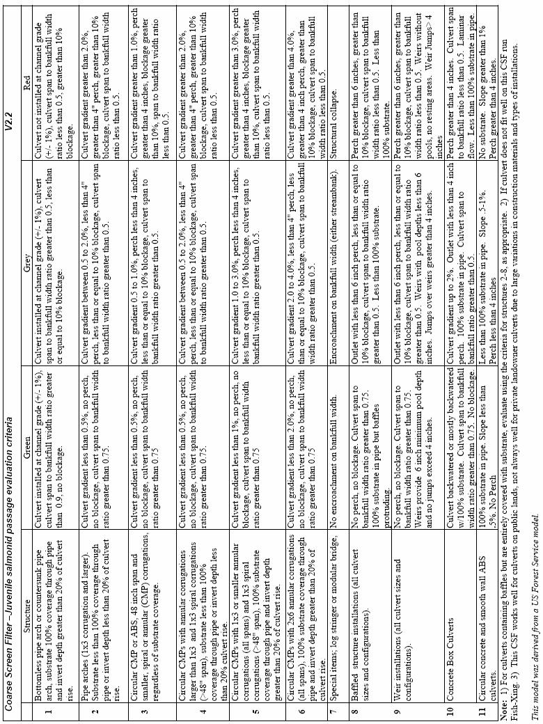
39 Appendices A. Fish Passage Through Road Crossing Assessment B. County Fish Passage Assessment Form C. BLM. Coarse Screen Filter Juvenile salmonid passage evaluation criteria Version 2.2. D. Wildlife Habitat Assessment E. High Priority Barrier Raw Data Page 36 of 36
40
41 Appendix A Fish Passage Through Road Crossing Assessment
42 Date: SITE INFORMATION Fish Passage Through Road Crossings Assessment RECORDER: Culvert: District: Salem District Field Office: Tillamook Resource Area 6 th Field Watershed Number: Stream Name: Road Number: 7.5-minute Quad: Surveyors: Road Name: UTM: Zone 10 East North NAD27 Legal Description: T., R., Sec., ¼ of ¼ Ownership: BLM USFS Private Private Industrial Other CULVERT STRUCTURE Barrel Shape Culvert Material Culvert Inlet Type Culvert Outlet Type Multiple Structures Box Spiral CMP Projected At streambed elevation Structure of Circular Annular CMP Mitered Cascade over riprap #Identical orifices- no extra form Open Bottom Arch SSP (Steel) Wingwall o Freefall into pool #Different orifices- w/ forms done Pipe-Arch ABS (Plastic) Wingwall o Freefall onto riprap #Overflow pipes- w/o forms done Concrete Headwall Outlet apron N/A Wood/Log Horizontal size End Sections Inlet End Sections Outlet Barrel Sections Width inches Culvert Condition Y N Y N U NA Diam. inches (Check all that apply) Bent inlet Headwall Inlet Headwall Outlet Diversion Potential (Stream) Vertical size Debris plugging inlet Y N Y N Y U N Height inches Bottom worn thru Diam. inches Water under culvert Inlet Alignment Baffles Rustline/Scour Fill eroding 0-30 o Y N Type Height in Ford Crossing None o Sag o Baffles Covered Outlet Scour F 1 Overall Condition Left/Right Y N Y N F 2 Good Fair Inlet Blockage Weirs Breaks in Slope Construction Poor Not Blocked Y N Type Y N 2 2/3x½ in. corr. Undetermined < 10% Blockage Weir Height in Horiz. Dist. from Outlet ft 3x1 in. corr. > 10% Blockage Max Pool Depth in Vert. Dist. To Break ft 5x1 in. corr. SSP 6x2 in. corr. Culvert/Drainage Device Smooth MA MI DD LC FD Shape and/or Condition Comments: SUBSTRATE Substrate in Culvert (Visual estimate. Circle one) Culvert (metal) Sand/Gravel Gravel/Cobble Cobble/Boulder Boulder/Log Bedrock Natural Bottom Roughness In Culvert (Visual estimate. Circle one) None Gravels with no riffles Smooth with Cobbles Gravels/Cobbles/Few Boulders Cobbles with Large Boulders Substrate in Channel (Visual estimate. Circle one) Sand/Gravel Gravel/Cobble Cobble/Boulder Boulder/Log Bedrock Natural Substrate in Culvert (rock-wood) =100% <100% Sunken Grade or At Grade (for FishXing) PHOTOGRAPHS Use digital camera if possible White Board photo number Culvert Interior (Outlet) View photo number Inlet photo number [s] Overall View photo number (from downstream) Outlet photo number [s] Others
43 CHANNEL DESCRIPTION Inlet Gradient: From pipe inlet 1 pipe diameter upstream (measured from channel bottom) Gradient Distance Width Ratio 0. Channel Gradient: Upstream 0. ft Beyond culvert influence (measured from water surface) Downstream 0. ft Bankfull Width: Upstream ft ft Beyond culvert influence Downstream ft ft Inlet Width to Bankfull Ratio: (Inlet)/ (Bankfull) LONGITUDINAL PROFILE These are rod heights you are measuring, except the horizontal distances Measurement Formula Value Height of the Instrument (HI) A ft Comments: Inlet Invert Elevation B 100 (A) (Rod Height) ft Outlet Invert Elevation C 100 (A) (Rod Height) ft Outlet Pool Length* ft Outlet Pool Depth (E) (D) ft Substrate/Pool Bottom Elevation D 100 (A) (Rod Height) ft Water Surface Elevation E 100 (A) (Rod Height) ft Outlet Pool Tailwater Depth* F ft Outlet Drop G (C) (E) ft Vertical Leap Distance* (F) + (G) ft Horizontal Leap Distance* ft Culvert Length H ft Culvert Slope (B) (C) / (H) 0. Invert Depth (Diameter or Height) (Depth) ft Average Water Depth In Culvert in Culvert Wall Thickness in Road Surface Type *If no Outlet Pool exists, do not survey these attributes. Drawings: Overall View from Upstream of culvert to Downstream of culvert. (Use additional sheets if needed) 0. Water Flow Near Culvert: Date Location cfs TAILWATER CROSS-SECTION (For FishXing. Calculate Using 100- (A) (Rod Height)) Station (ft) 0.0 Elevation (ft) Calculated El. (ft) Notes Substrate at Tailwater Cross-Section (Visual estimate only. Circle one) Gravels with no riffles Smooth with Cobbles Gravels/Cobbles/Few Boulders Cobbles with Large Boulders Channel Gradient Length (ft) Channel Gradient at Tailwater Control 0.
44 Date: Fish Passage Evaluation Culvert: FISH INFORMATION List up to 3 species and life stages by Priority First is highest First Second Third Species (R) Critical Life Stage (adult or juvenile) (R) Fish Length (mm) (R) Water Depth Migration Season (Winter, Spring, Summer, Fall) (O) HABITAT INFORMATION Upstream Downstream Number of Culverts (list) Number of Known Barriers (list) Distance to Culvert Barriers (stream) Length of Historical Upstream Habitat FISH PASSAGE COARSE SCREEN FILTER EVALUATION: GREEN GREY RED FISHXING EVALUATION: GREEN GREY RED ADDITIONAL MEASUREMENTS & COMMENTS Water Flow Near Culvert: Date Location cfs
45 Appendix B County Fish Passage Assessment Form
46 Washington County Fish Passage Assessment Date: Recorder: Culvert Location/Identification 1st Pass (Coarse Screen Filter) Road Perch Height (in) Milepost Inlet Blockage (%) Stream Upstream bankfull w. (ft) Culvert Key # Downstream bankfull w. (ft) Asset # Avg. bankfull width (ft) GPS Latitude IW / BFW Ratio GPS Longitude Upstream Gradient Culvert Information Downstream Gradient Shape Average Gradient Material Corrugation Culvert Slope Instrument Height, HI (ft) Length (ft) Inlet Elevation (ft) Width (ft) Outlet Elevation (ft) Height (ft) Slope: (IE-OE)/length Number of culverts Diversion Potential: 2nd Pass (Fine Screen Filter) Embedded (Y/N) Channel Condition (0-10) Depth of fill (ft) Flow Complexity (0-10) Type of bed material Embeddedness (0-10) Constant outlet pool (Y/N) Cover (0-10) Outlet pool length (ft) Bank Stability (0-10) Outlet pool bottom elev. (ft) Riparian Zone (0-10) Water surface elevation (ft) Stream Habitat Quality Additional Notes: Inlet and outlet type, culvert condition, wiers, baffles, outlet scour, other comments
47 Outlet Channel Cross-Section: Station Elevation Distance Station 1 Station 2 Station 3 Station 4 Station 5 Station 6 Station 7 Station 8 Station 9 Station 10 Station 11 Station 12 Drawing of Stream Crossing Additional Comments:
48 Appendix C BLM Coarse Screen Filter Juvenile salmonid passage evaluation criteria Version 2.2
49
Five Counties Salmonid Conservation Program - Fish Passage Design Workshop. February 2013
 Program - Aquatic Organisms and Stream Crossings Ecological Connectivity A watershed is a network of channels that drain a common boundary. Channel characteristics formed by interaction of precipitation,
Interim Guidance Fish Presence Absence
 Interim Guidance Fish Presence Absence Source: Forest Practices Act Guidance for Division 635 of the forest practices act dealing with stream classification when no fish surveys have been done (referenced
SELBY CREEK SILVERADO TRAIL CULVERT FISH PASSAGE ASSESSMENT
 SELBY CREEK SILVERADO TRAIL CULVERT FISH PASSAGE ASSESSMENT NAPA COUNTY, CALIFORNIA PREPARED BY NAPA COUNTY RESOURCE CONSERVATION DISTRICT 1303 JEFFERSON ST. SUITE 500B NAPA, CALIFORNIA 94559 WWW.NAPARCD.ORG
Fish Passage Culvert Assessment for Cahilty Creek Watershed FIA Project #
 Fish Passage Culvert Assessment for Cahilty Creek Watershed FIA Project # 4602004 Prepared for Weyerhaeuser Company Ltd. Jason Ladyman R.P.F. 1550 Mission Flats Road PO Box 40 Kamloops BC V2C 5K3 Prepared
Fish Passage at Road Crossings Assessment Boise National Forest FY 2004
 Culvert Inventory Summary 2004 - Boise National Forest Fish Passage at Road Crossings Assessment Boise National Forest FY 2004 Feather River at Road #135 Crossing By Michael S. Kellett, Fishery Biologist
FINAL REPORT. Yonkers Creek Migration Barrier Removal Project Wonderstump Road Del Norte County. Submitted By:
 FINAL REPORT Yonkers Creek Migration Barrier Removal Project Wonderstump Road Del Norte County Submitted By: Del Norte County Community Development Department Yonkers Creek Migration Barrier Removal Project
Fish Passage Assessment of Private Stream Crossings on Lower Stonybrook Creek
 Fish Passage Assessment of Private Stream Crossings on Lower Stonybrook Creek Prepared by: Michael Love & Associates In cooperation with: Center for Ecosystem Management and Restoration Funded by: Coastal
FISH PASSAGE IMPROVEMENT in California s Watersheds. Assessments & Recommendations by the Fish Passage Forum
 FISH PASSAGE IMPROVEMENT in California s Watersheds Assessments & Recommendations by the Fish Passage Forum FISH PASSAGE IMPROVEMENT in California s Watersheds The mission of the Fish Passage Forum is
Newaukum Watershed Culvert Assessment
 Newaukum Watershed Culvert Assessment Water Resource Inventory Area 23 Lewis County Conservation District Final Report By: Kelly Verd and Nikki Wilson July 2002 Funded by: Chehalis Fisheries Restoration
CHAPTER 5 CULVERT DESIGN
 CHAPTER 5 CULVERT DESIGN HYDRAULICS OF CULVERTS There are two major types of culvert flow: 1) flow with inlet control, and 2) flow with outlet control. For each type, different factors and formulas are
STREAM SURVEY File form No..
 scanned for KRIS THE RESOURCES AGENCY OF CALIFORNIA California Department of Fish and Game STREAM SURVEY File form No.. Date: September 4, 1969. NAME: North Fork Schooner Gulch Creek COUNTY: Mendocino.
Washington State Fish Passage Barrier Removal Projects. Casey Kramer, PE WSDOT State Hydraulics Engineer
 Washington State Fish Passage Barrier Removal Projects Casey Kramer, PE WSDOT State Hydraulics Engineer 2014 National Hydraulic Engineering Conference Iowa City, IA August 20 th, 2014 WSDOT Fish Passage
Project Report for Marsh Creek and Albion River Instream Fish Barrier Removal Flynn Creek Road, CR 135, M.P. 8.1 and 8.3
 Project Report for Marsh Creek and Albion River Instream Fish Barrier Removal Flynn Creek Road, CR 135, M.P. 8.1 and 8.3 Project Title: Marsh Creek and Albion River Instream Fish Barrier Removal, Flynn
CALIFORNIA SALMONID STREAM HABITAT RESTORATION MANUAL APPENDIX IX-A CULVERT CRITERIA FOR FISH PASSAGE INTRODUCTION
 APPENDIX IX-A STATE OF CALIFORNIA RESOURCES AGENCY DEPARTMENT OF FISH AND GAME CULVERT CRITERIA FOR FISH PASSAGE For habitat protection, ecological connectivity should be a goal of stream-road crossing
Aquatic Organism Passage at Road-Stream Crossings CHUCK KEEPORTS FOREST HYDROLOGIST ALLEGHENY NATIONAL FOREST WARREN, PENNSYLVANIA
 Aquatic Organism Passage at Road-Stream Crossings CHUCK KEEPORTS FOREST HYDROLOGIST ALLEGHENY NATIONAL FOREST WARREN, PENNSYLVANIA TOPICS COVERED Aquatic Organism Passage (AOP) Benefits of AOP Crossings
Packwood Hydroelectric Project Barrier Analysis December 12, 2006
 Packwood Hydroelectric Project Barrier Analysis December 12, 2006 Study Area Natural barriers to upstream fish passage on Lake Creek at RM 1.03 and RM 1.95 Snyder Creek culvert under the Project tailrace
Project Completion Abstract Fish Passage Activity ( Engineering Activities)
") Project Completion Abstract Fish Passage Activity ( Engineering Activities) SUBMIT COMPLETED FORM TO DISTRICT MANAGER AND FIA ADMINISTRATOR AFTER PROJECT COMPLETION SECTION A GENERAL INFORMATION Recipient:
Project Completion Abstract Fish Passage Activity ( Engineering Activities) SUBMIT COMPLETED FORM TO DISTRICT MANAGER AND FIA ADMINISTRATOR AFTER PROJECT COMPLETION SECTION A GENERAL INFORMATION Recipient:
Sub-watershed Summaries
 Project Description The Salmon Drift Creek Watershed Council (SDCWC) has focused their efforts in the Salmon River estuary for the past few years. The multifaceted partnership effort is nearing completion
South Fork Chehalis Watershed Culvert Assessment
 South Fork Chehalis Watershed Culvert Assessment Water Resource Inventory Area 23 Lewis County Conservation District Final Report By: Kelly Verd and Nikki Wilson March 2003 Funded by: The Washington State
Culvert Design for Low and High Gradient Streams in the Midwest. Dale Higgins, Hydrologist Chequamegon-Nicolet National Forest
 Culvert Design for Low and High Gradient Streams in the Midwest Dale Higgins, Hydrologist Chequamegon-Nicolet National Forest Overview Culvert Design Considerations Hydraulic Terms Culvert Impacts Low
Oregon Department of Transportation (ODOT) Culvert Repair Fish Passage Pilot Programmatic Agreement Final ODFW Report
 Culvert Repair Fish Passage Pilot Programmatic Agreement Final ODFW Report") Oregon Department of Transportation (ODOT) Culvert Repair Fish Passage Pilot Programmatic Agreement 2014-17 Final ODFW Report Prepared by Pete Baki June 27, 2018 Table of Contents 1 Background 4 Culvert
Oregon Department of Transportation (ODOT) Culvert Repair Fish Passage Pilot Programmatic Agreement 2014-17 Final ODFW Report Prepared by Pete Baki June 27, 2018 Table of Contents 1 Background 4 Culvert
FSOC Upstream Fish Passage Guidance Document
 FSOC Upstream Fish Passage Guidance Document STEP 1: Identify species and life stages in need of fish passage STEP 2: Identify fishway options and species applicability STEP 3 Fish passage criteria review
3. The qualification raised by the ISRP is addressed in #2 above and in the work area submittal and review by the ISRP as addressed in #1.
 Please find attached a response from The Confederated Tribes of the Warm Springs Reservation of Oregon (CTWSRO) for Project # 2008-301-00, Habitat Restoration Planning, Design and Implementation within
Mid-Columbia Fisheries Enhancement Group Annual Report Fiscal Year 06: July 1, 2005 June 30, 2006
 Mid-Columbia Fisheries Enhancement Group Annual Report Fiscal Year 06: July 1, 2005 June 30, 2006 Mission Statement The mission of the Mid-Columbia Fisheries Enhancement Group is to restore self-sustaining
Annual Report for Fiscal Year and Future Plans for the Tillamook Bay Watershed Council
 Annual Report for Fiscal Year 2012-2013 and Future Plans for the Tillamook Bay Watershed Council A report prepared for the Tillamook County Board of Commissioners August 2013 Table of Contents: Recently
Great Lakes Stream Crossing Inventory Instructions
 Great Lakes Stream Crossing Inventory Instructions This document is a guide to completing the Stream Crossing Data Sheet (2/28/11 version). Careful attention to this guidance will ensure consistent crossing
OREGON DEPARTMENT OF FISH AND WILDLIFE ROGUE FISH DISTRICT REPORT
 OREGON DEPARTMENT OF FISH AND WILDLIFE ROGUE FISH DISTRICT REPORT TITLE: Upper Rogue Smolt Trapping Project, 1999 STREAM: Big Butte, Little Butte, South Fork Big Butte, Slate and West Fork Evans Creeks
Assessing Ecosystem Impacts from Road Stream Crossings through Community Involvement
 Assessing Ecosystem Impacts from Road Stream Crossings through Community Involvement Background Why is the NH Fish and Game Department interested in culverts? Block fish migration Reduce opportunities
(Revised February,2005) CULVERTS, BRIDGES, AND FORDS
 CULVERTS, BRIDGES, AND FORDS") GUIDE TO STREAM CROSSINGS (Revised February,2005) CULVERTS, BRIDGES, AND FORDS Culverts, bridges, and fords are all methods used to cross-streams. Culverts are the most common stream crossing structure.
GUIDE TO STREAM CROSSINGS (Revised February,2005) CULVERTS, BRIDGES, AND FORDS Culverts, bridges, and fords are all methods used to cross-streams. Culverts are the most common stream crossing structure.
Union Pacific Railroad
 Input Questions: 404/401 Pre Application Meeting, December 18, 2013, Portland, Oregon 1. What is the project purpose and need? The purpose of the project is to improve the efficiency and average velocity
Massachusetts Stream Crossing Case Studies
 Massachusetts Stream Crossing Case Studies Amy Singler Associate Director, River Restoration Program Carrie Banks River Continuity Coordinator Case Studies: Public Benefits: Movement of goods and people
Study Update Fish Distribution and Species Composition
 Study Update Fish Distribution and Species Composition Goals and Study Area Gain a better understanding of fish species composition and abundance in waters associated with the Packwood Lake Hydroelectric
Oregon Coast Coastal Cutthroat Trout
 Oregon Coast Coastal Cutthroat Trout Species Management Unit Description The Oregon Coast Coastal Cutthroat Trout Species Management Unit (SMU) includes all populations of cutthroat trout inhabiting ocean
Southern Oregon Coastal Cutthroat Trout
 Species Management Unit Description Southern Oregon Coastal Cutthroat Trout The Southern Oregon Coastal Cutthroat Trout SMU includes all populations of cutthroat trout inhabiting ocean tributary streams
OREGON DEPARTMENT OF FISH AND WILDLIFE ROGUE WATERSHED DISTRICT REPORT INTRODUCTION
 OREGON DEPARTMENT OF FISH AND WILDLIFE ROGUE WATERSHED DISTRICT REPORT TITLE: Upper Rogue Smolt Trapping Project, 2003 STREAM: Bear, Little Butte, Elk, Slate and West Fork Evans Creeks and the Little Applegate
Stream Crossings I: Engineering and Design Approaches to Provide Fish Passage at Culvert Slipline Projects in Connecticut
 University of Massachusetts - Amherst ScholarWorks@UMass Amherst International Conference on Engineering and Ecohydrology for Fish Passage International Conference on Engineering and Ecohydrology for Fish
Trout Unlimited Comments on the Scope of Environmental Impact Statement for the Constitution Pipeline Project, Docket No. PF12-9
 October 9, 2012 Kimberly D. Bose, Secretary Federal Energy Regulatory Commission 888 First Street, NE, Room 1A Washington, DC 20426 RE: Trout Unlimited Comments on the Scope of Environmental Impact Statement
Redd Dewatering and Juvenile Salmonid Stranding in the Lower Feather River,
 Redd Dewatering and Juvenile Salmonid Stranding in the Lower Feather River, 2005-2006 Interim Report for NOAA Fisheries Prepared by: California Department of Water Resources Division of Environmental Services
APPENDIX B: CATALOG OF SISKIYOU COUNTY CULVERTS LOCATED ON FISH-BEARING STREAM REACHES. Prepared for the Siskiyou County Public Works Department
 APPENDIX B: CATALOG OF SISKIYOU COUNTY CULVERTS LOCATED ON FISH-BEARING STREAM REACHES Prepared for the Siskiyou County Public Works Department By Ross Taylor and Associates 1254 Quail Run Court McKinleyville,
HEC 26 Aquatic Organism Passage Design Manual Evolution & Application
 HEC 26 Aquatic Organism Passage Design Manual Evolution & Application Sven Leon, P.E., Hydraulics Engineer Federal Highway Administration 2015 Alaska Fish Passage Meeting October 13 14, 2015 VTRC, Juneau,
Final Bull Trout Genetics Monitoring Plan for the Wallowa Falls Hydroelectric Project. (FERC No. P-308) June 2017
 June 2017") Final for the Wallowa Falls Hydroelectric Project (FERC No. P-308) June 2017 Prepared by: Jeremiah Doyle PacifiCorp 825 NE Multnomah Street Portland, OR 97232 June, 2017 Page 1 of 8 Table of Contents 1.0
Final for the Wallowa Falls Hydroelectric Project (FERC No. P-308) June 2017 Prepared by: Jeremiah Doyle PacifiCorp 825 NE Multnomah Street Portland, OR 97232 June, 2017 Page 1 of 8 Table of Contents 1.0
Understanding the Impacts of Culvert Performance on Stream Health
 Understanding the Impacts of Culvert Performance on Stream Health Kristin Thomas Aquatic Ecologist Michigan Trout Unlimited Transportation and the Environment Conference 12/5/2018 Importance of adequately
DEADWOOD CREEK FISH PASSAGE IMPROVEMENT PROJECT
 DEADWOOD CREEK FISH PASSAGE IMPROVEMENT PROJECT Coho Salmon in Deadwood Creek Project Area - November 2, 2004 FINAL REPORT National Fish and Wildlife Foundation Project #2002-0368-014 CA Department of
Fish Passage Culvert Inspection (FPCI) 12 Sites on TFL 18 (FIA ) 1 Site on FL #A18688 (Thuya Creek) (FIA )
 12 Sites on TFL 18 (FIA ) 1 Site on FL #A18688 (Thuya Creek) (FIA )") Fish Passage Culvert Inspection (FPCI) 12 Sites on TFL 18 (FIA 444603) 1 Site on FL #A18688 (Thuya Creek) (FIA 450502) Prepared for: Canadian Forest Products Ltd. Vavenby Division Prepared by: Doug Wahl,
Fish Passage Culvert Inspection (FPCI) 12 Sites on TFL 18 (FIA 444603) 1 Site on FL #A18688 (Thuya Creek) (FIA 450502) Prepared for: Canadian Forest Products Ltd. Vavenby Division Prepared by: Doug Wahl,
1.Mill Creek Watershed Summary Description and Land Use
 1.Mill Creek Watershed Summary Description and Land Use Table xxx: Mill Creek Watershed Overview Watershed Size 31,435 acres/49.1 sq miles/ 127.1 sq km Elevation Range 5,594 feet [4,967-10,561] Stream
MEMORANDUM Oregon Department of Fish and Wildlife
 MEMORANDUM Oregon Department of Fish and Wildlife Date: January 18, 2019 To: From: Oregon Fish and Wildlife Commission Greg Apke, ODFW Statewide Fish Passage Program Coordinator Tom Murtagh, North Willamette
Study Update Tailrace Slough Use by Anadromous Salmonids
 Study Update Tailrace Slough Use by Anadromous Salmonids Goals and Objectives Identify what anadromous salmonids use the tailrace slough by: Life Stage (Juvenile, migrating and spawning adults) Timing
BC Ministry of Forests. March Fish Stream Crossing Guidebook. Forest Practices Code of British Columbia.
 FRST 557 Lecture 7c Bridges and Culverts: Water Velocity and Discharge Lesson Background and Overview: The previous two lessons presented methods for estimating water volume flow at a particular site and
APPENDIX D: North Fork Nooksack Sub-basin Report
 APPENDIX D: North Fork Nooksack Sub-basin Report WHATCOM COUNTY FISH PASSAGE ASSESSMENT SUBBASIN REPORT NORTH FORK NOOKSACK RIVER Description of Sub-basin The North Fork Nooksack River originates at an
Culvert Design An Overview of the NYS Highway Design Manual Chapter 8
 Seventeenth Statewide Conference on Local Bridges Culvert Design An Overview of the NYS Highway Design Manual Chapter 8 Tuesday, October 25, 2011 Training Session: Culvert Design, Analysis - talk 2 Presented
Steelhead Society of BC. Thompson River Watershed Restoration and Enhancement Project #4 Nicola River Bank Stabilization and Enhancement Project
 Steelhead Society of BC Presents: Thompson River Watershed Restoration and Enhancement Project #4 Nicola River Bank Stabilization and Enhancement Project Application for Funding December 2013 1.0 BACKGROUND
Chadbourne Dam Repair and Fish Barrier
 Chadbourne Dam Repair and Fish Barrier Final Report for the Western Native Trout Initiative Prepared by: Carol Endicott Yellowstone Cutthroat Trout Conservation Biologist Montana Fish, Wildlife & Parks
State of San Francisco Bay 2011 Appendix O Steelhead Trout Production as an Indicator of Watershed Health
 State of San Francisco Bay 2011 Appendix O Steelhead Trout Production as an Indicator of Watershed Health Gordon Becker and Katherine Smetak, Center for Ecosystem Management and Restoration 290 Introduction
Fish Passage Culvert Inspection (FPCI) Nicklen Creek Watershed
 Nicklen Creek Watershed") Fish Passage Culvert Inspection (FPCI) Nicklen Creek Watershed FPCI Sites funded by FIA Prepared for: Tolko Industries Ltd., Okanagan Regional Woodlands & British Columbia Timber Sales, Okanagan-Shuswap
Fish Passage Culvert Inspection (FPCI) Nicklen Creek Watershed FPCI Sites funded by FIA Prepared for: Tolko Industries Ltd., Okanagan Regional Woodlands & British Columbia Timber Sales, Okanagan-Shuswap
CHAPTER 4 SPALDING COUNTY, GEORGIA 4.0 CULVERT DESIGN
 SPALDING COUNTY, GEORGIA CHAPTER 4 4.0 CULVERT DESIGN... 4-1 4.1 INTRODUCTION... 4-1 4.2 SYMBOLS AND DEFINITIONS... 4-1 4.3 ENGINEERING DESIGN CRITERIA... 4-2 4.3.1 FREQUENCY FLOOD... 4-2 4.3.2 VELOCITY
Abundance of Steelhead and Coho Salmon in the Lagunitas Creek Drainage, Marin County, California
 scanned for KRIS Abundance of Steelhead and Coho Salmon in the Lagunitas Creek Drainage, Marin County, California Prepared for: Marin Municipal Water District 220 Nellen Drive Corte Madera, California
Executive Summary. Map 1. The Santa Clara River watershed with topography.
 Santa Clara River Steelhead Trout: Assessment and Recovery Opportunities December 2005 Prepared By: Matt Stoecker and Elise Kelley, Ph.D. University of California, Santa Barbara Prepared For: The Santa
APPENDIX A STRUCTURE DESCRIPTIONS AND RATING CURVES
 3 4 5 6 7 8 9 0 3 APPENDIX A STRUCTURE DESCRIPTIONS AND RATING CURVES Kissimmee River Vol December 005 Version Draft 4 3 4 5 6 7 8 9 0 3 4 5 6 7 8 9 0 3 4 5 6 7 8 9 30 3 3 33 34 35 36 37 38 39 40 4 4 43
Simulating Streams Through Culverts in Mat-Su, Alaska
 Simulating Streams Through Culverts in Mat-Su, Alaska Project Managers Bill Rice, P.E., USFWS Hydrologist Mary Price, USFWS Fishery Biologist The Team Approach US Fish and Wildlife Service Bill Rice, P.E.,
Data Report : Russian River Basin Steelhead and Coho Salmon Monitoring Program Pilot Study
 Data Report 1999-1: Russian River Basin Steelhead and Coho Salmon Monitoring Program Pilot Study Sonoma County Water Agency 215 West College Avenue Santa Rosa, California 951 Prepared by David Cook Senior
Eastern Brook Trout Joint Venture Annual Report The Nature Conservancy 2013
 Eastern Brook Trout Joint Venture Annual Report The Nature Conservancy 2013 2013 Annual Performance Report Enhancing Connectivity in the Ash-Black Rock Sub-basin of the West Branch Narraguagus River. Project
Final Bull Trout Redd Monitoring Report for the Wallowa Falls Hydroelectric Project
 Final for the Wallowa Falls Hydroelectric Project East Fork Wallowa River barrier to upstream fish migration, photo courtesy of Kendrick Moholt (FERC No. P-308) December 18, 2017 Prepared by: Jeremiah
Presented by Fred Halterman, URS Jennie Agerton, URS
 Presented by Fred Halterman, URS Jennie Agerton, URS What is Eco Friendly Culvert Design? Culvert design that: Maintains connectivity for aquatic organism migration Maintains connectivity for gene flow
Rehabilitation of Grimes Creek, a Stream Impacted in the Past by Bucket-lined Dredge Gold Mining, Boise River Drainage, July 2008 to August 2011.
 Rehabilitation of Grimes Creek, a Stream Impacted in the Past by Bucket-lined Dredge Gold Mining, Boise River Drainage, July 2008 to August 2011. Pam Harrington TU,1020 W. Main Street Suite 440, Boise,
CHAPTER 4 DESIRED OUTCOMES: VISION, GOALS, AND OBJECTIVES
 CHAPTER 4 DESIRED OUTCOMES: VISION, GOALS, AND OBJECTIVES Vision One of the first steps in developing this Plan was articulating a vision - a clear statement of what the Plan strives to achieve and what
Assessment of Baseline Geomorphic Features at. Proposed Stream Crossings On The Proposed County Road 595. Marquette County, Michigan
 Assessment of Baseline Geomorphic Features at Proposed Stream Crossings On The Proposed County Road 595 Marquette County, Michigan Prepared for: Kennecott Eagle Minerals Company Marquette, Michigan Prepared
Potlatch River Drainage: Salmonid Presence: Largest lower Clearwater River tributary
 X Y Potlatch River Drainage: Largest lower Clearwater River tributary Area = 1500 km 2 Mouth ~ 13 km upstream of Snake/Clearwater confluence X Y Dominated by private land Salmonid Presence: Steelhead,
Concurrent Sessions C: Prioritization - Oregon Fish Passage Priority List - A Statewide Barrier Prioritization Effort
 University of Massachusetts - Amherst ScholarWorks@UMass Amherst International Conference on Engineering and Ecohydrology for Fish Passage International Conference on Engineering and Ecohydrology for Fish
Management of headwater streams in the White Mountain National Forest
 Management of headwater streams in the White Mountain National Forest White Mountain National Forest Weeks Act of 1911 authorized the federal government to purchase lands east of the Mississippi River
STEELHEAD SURVEYS IN OMAK CREEK
 STEELHEAD SURVEYS IN OMAK CREEK 2002 Annual Report Prepared by Chris Fisher John Arterburn Colville Confederated Tribes Fish and Wildlife Department P.O. Box 150 Nespelem, WA 99155 Prepared for Project
COA-F17-F-1343 YEAR END REPORT
 DAVE MARSHALL SALMON RESERVE RESTORATION, MAINTENANCE, AND UPGRADES YEAR END REPORT Prepared for: Fish and Wildlife Compensation Program Prepared by: Edith Tobe, RPBio, Executive Director Box 1791, Squamish,
The Blue Heron Slough Conservation Bank
 1 The Blue Heron Slough Conservation Bank CONSERVATION BANKING July 19-23, 2010 CASE STUDY SERIES The Blue Heron Slough Conservation Bank (Washington) I. OVERVIEW & BACKGROUND: Location: Snohomish River
Outlet Structures T-12
 Description This section provides guidance and details for outlet structures for use primarily with BMPs utilizing sedimentation, (i.e., extended detention basins (EDBs), retention ponds, and constructed
Study No. 18. Mystic Lake, Montana. PPL Montana 45 Basin Creek Road Butte, Montana 59701
 Study No. 18 Evaluation of the Current Fish Population and Habitat in West Rosebud Creek Downstream from Emerald Lake Mystic Lake Hydroelectric Project FERC No. 2301 Mystic Lake, Montana PPL Montana 45
Big Spring Creek Habitat Enhancement and Fishery Management Plans
 Big Spring Creek Habitat Enhancement and Fishery Management Plans November 5, 2012 Big Spring Events and Activities Center Newville, PA Charlie McGarrell Regional Habitat Biologist Pennsylvania Fish and
Minnesota Department of Natural Resources Division of Fish and Wildlife Section of Fisheries. Stream Survey Report. Luxemburg Creek.
 Minnesota F-29-R(P)-24 Area 315 Study 3 March 2016 Minnesota Department of Natural Resources Division of Fish and Wildlife Section of Fisheries Stream Survey Report Luxemburg Creek 2015 Mark Pelham Sauk
Amendment to a Biological Assessment/Evaluation completed for the Coon Creek Land Disposal completed December Grand Valley Ranger District
 Amendment to a Biological Assessment/Evaluation completed for the Coon Creek Land Disposal completed December 2007 Grand Valley Ranger District Grand Mesa, Uncompahgre, Gunnison National Forests Prepared
Climate Change Adaptation and Stream Restoration. Jack Williams;
 Climate Change Adaptation and Stream Restoration Jack Williams; jwilliams@tu.org 1 Goals for this presentation Develop strategies for adapting streams to climate impacts by Thinking like a watershed Understanding
Indiana LTAP Road Scholar Core Course #10 Culvert Drainage. Presented by Thomas T. Burke, Jr., PhD, PE Christopher B. Burke Engineering, Ltd.
 Indiana LTAP Road Scholar Core Course #10 Culvert Drainage Presented by Thomas T. Burke, Jr., PhD, PE Christopher B. Burke Engineering, Ltd. Objectives Review culvert shapes, end sections, and materials
2012 Bring Back the Natives Awarded Projects
 2012 Bring Back the Natives Awarded Projects EZG # Organization Project Title Project Description Location Description Total Award Amount Grantee Non- Federal Match 31904 Sanctuary Forest, Inc. Mattole
Fish Passage Assessment Report Mare Brook Culverts
 Fish Passage Assessment Report Mare Brook Culverts Fish Passage Assessment Component of Mare Brook Watershed Assessment and Community Engagement Project Prepared for: FB Environmental Associates 97A Exchange
Michigan Department of Natural Resources Status of the Fishery Resource Report Page 1
 Michigan Department of Natural Resources 2008-59 Status of the Fishery Resource Report Page 1 Bowens Manistee County, (T24N R16W Sec. 11, 12, 13, 14, 15, 24, and 30). Last surveyed 2008 Mark A. Tonello
Discussion on the Selection of the Recommended Fish Passage Design Discharge
 Discussion on the Selection of the Recommended Fish Passage Design Discharge Introduction The provision of fish passage is a requirement for most proposed culvert and bridge installations in Alberta, depending
WMS 8.4 Tutorial Hydraulics and Floodplain Modeling HY-8 Modeling Wizard Learn how to model a culvert using HY-8 and WMS
 v. 8.4 WMS 8.4 Tutorial Hydraulics and Floodplain Modeling HY-8 Modeling Wizard Learn how to model a culvert using HY-8 and WMS Objectives Define a conceptual schematic of the roadway, invert, and downstream
1998 Willow Creek Downstream Migrant Trap Report. Draft. Prepared By: C. A. Walker. Lower Trinity Ranger District. Six Rivers National Forest
 1998 Willow Creek Downstream Migrant Trap Report Draft Prepared By: C. A. Walker Lower Trinity Ranger District Six Rivers National Forest September 1998 Executive Summary The downstream migrant trap was
ADDENDA B Hydrologic and Hydraulic (H&H) Study Guidance 2019
 Study Guidance 2019") 09/25/2018 DRAFT FEMA Region I PA H&H Study ADDENDA B Hydrologic and Hydraulic (H&H) Study Guidance 2019 Region I Federal Emergency Management Agency (FEMA) Public Assistance Hydrologic and Hydraulic (H&H)
09/25/2018 DRAFT FEMA Region I PA H&H Study ADDENDA B Hydrologic and Hydraulic (H&H) Study Guidance 2019 Region I Federal Emergency Management Agency (FEMA) Public Assistance Hydrologic and Hydraulic (H&H)
Firth Creek Habitat Enhancement Project 1993
 Firth Creek Habitat Enhancement Project 1993 A. R. Langston December 1993 PWFWCP Report No. 77 The Peace/Williston Fish & Wildlife Compensation Program is a cooperative venture of BC Hydro and the provincial
WHATCOM COUNTY FISH PASSAGE BARRIER INVENTORY FINAL REPORT
 WHATCOM COUNTY FISH PASSAGE BARRIER INVENTORY FINAL REPORT January, 2006 IAC Project Number: 01-1258 N Project Sponsor: Whatcom County Public Works 5280 Northwest Drive, Suite C Bellingham, WA 98226 Grant
2 nd Steelhead Summit. October 27 & 28, 2016 in San Luis Obispo, CA
 + 2 nd Steelhead Summit October 27 & 28, 2016 in San Luis Obispo, CA 1 + Session Overview Sponsors: California Trout City of San Luis Obispo Sustainable Conservation California Conservation Corps Cachuma
General Information for Culvert Design
 Design Manual Chapter 2 - Stormwater 2E - Culvert Design 2E-1 General Information for Culvert Design A. Introduction A culvert is a conduit under an embankment that transports stormwater from one side
NEVADA DEPARTMENT OF WILDLIFE STATEWIDE FISHERIES MANAGEMENT
 NEVADA DEPARTMENT OF WILDLIFE STATEWIDE FISHERIES MANAGEMENT FEDERAL AID JOB PROGRESS REPORT F-20-50 2014 LAHONTAN CUTTHROAT TROUT STUDY WESTERN REGION NEVADA DEPARTMENT OF WILDLIFE, FISHERIES DIVISION
Chinook Salmon Spawning Study Russian River Fall 2005
 Chinook Salmon Spawning Study Russian River Fall 2005 Sonoma County Water Agency 2150 West College Avenue Santa Rosa, California 95401 Prepared by David Cook - Senior Environmental Specialist March 27,
APPENDIX B: CATALOG OF HUMBOLDT COUNTY CULVERTS LOCATED ON FISH-BEARING STREAM REACHES
 APPENDIX B: CATALOG OF HUMBOLDT COUNTY CULVERTS LOCATED ON FISH-BEARING STREAM REACHES NOTE: This catalog contains a single page for each culvert included in the inventory. Generally, they are ordered
Fish Migration Barrier Severity and Steelhead Habitat Quality in the Malibu Creek Watershed
 Fish Migration Barrier Severity and Steelhead Habitat Quality in the Malibu Creek Watershed Produced for California State Coastal Conservancy and California Department of Parks and Recreation By: Heal
San Lorenzo Valley Water District, Watershed Management Plan, Final Version Part I: Existing Conditions Report
 LIST OF FIGURES Figure 1-1. Map of the San Lorenzo River watershed Figure 2-1. The Santa Cruz Mountains Bioregion Figure 2-2. Protected areas within the San Lorenzo River watershed Figure 2-3. Primary
Alberta Conservation Association 2017/18 Project Summary Report
 Alberta Conservation Association 2017/18 Project Summary Report Project Name: Abundance, Distribution, Spawning, and Thermal Habitat of Westslope Cutthroat Trout and Bull Trout in the Stimson Creek Watershed
APPENDIX J HYDROLOGY AND WATER QUALITY
 APPENDIX J HYDROLOGY AND WATER QUALITY J-1 Technical Report on Airport Drainage, Northern Sector Airport and Ordinance Creek Watershed / Preliminary Creek Constructed Natural Channel Culvert J-2 Preliminary
NEVADA DEPARTMENT OF WILDLIFE STATEWIDE FISHERIES MANAGEMENT
 NEVADA DEPARTMENT OF WILDLIFE STATEWIDE FISHERIES MANAGEMENT FEDERAL AID JOB PROGRESS REPORTS F-20-52 2016 Lake Tahoe Rainbow Trout Study WESTERN REGION NEVADA DEPARTMENT OF WILDLIFE, FISHERIES DIVISION
Stonybrook Creek Fish Passage Assessment
 Stonybrook Creek Fish Passage Assessment Prepared for Alameda County Public Works Agency BY MICHAEL LOVE APRIL 6, 2001 effgerfgw MICHAEL LOVE & ASSOCIATES P.O. BOX 4477 ARCATA, CA 95518 (707) 839-7867
ASSESSMENT OF THE STATUS OF NESTUCCA RIVER WINTER STEELHEAD
 ASSESSMENT OF THE STATUS OF NESTUCCA RIVER WINTER STEELHEAD Gary Susac and Steve Jacobs Coastal Salmonid Inventory Project Oregon Department of Fish and Wildlife August 21, 2001 INTRODUCTION This report