Ontario Ministry of Transportation (MTO) Restoring Fish Passage to a Tributary of the Saugeen River
|
|
|
- Cassandra Fowler
- 6 years ago
- Views:
Transcription


1 Ontario Ministry of Transportation (MTO) Restoring Fish Passage to a Tributary of the Saugeen River 2017 Transportation Association of Canada Environmental Achievement Award Nomination Submission Prepared by: Kirstie Houston Environmental Planner Ontario Ministry of Transportation March 2017
2 Acknowledgements The Ontario Ministry of Transportation would like to thank all who contributed to the successful completion of this project: Ken Hannaford, Environmental Scientist, Government of Newfoundland and Labrador (Baffle Design) Jason Duguay, Civil Engineering PhD candidate, University of Sherbrooke (Modelling) Valerie Nantais, Project Engineer, Ministry of Transportation Kirstie Houston, Environmental Planner, Ministry of Transportation Adele Mochrie, Environmental Planner, Ministry of Transportation Jonathan Wilson, Contract Services Administrator, Ministry of Transportation Doran Ritchie, Land Use Planner, Saugeen Ojibway Nation Dave Penny, Executive Director Emeritus, Corrugated Steel Pipe Institute Dan Green, Consultant Project Engineer, MMM Group Ltd. Tisha Doucette, Fisheries Biologist, Parsons Courtney Beneteau, Fisheries Biologist, Parsons Julie Scott, Terrestrial Biologist, Parsons Rob Amos, Fluvial Geomorphologist, Aquafor Beech The Murray Group (Construction) Noveen (Contract Administration)
3 Contents 1.0 Introduction Environmental Protection and Enhancement Innovation Financial Implications Applicability to Transportation Conclusion... 7 Appendices Appendix A Location of the Highway 21 Craig St. Culvert Appendix B Original Culvert Appendix C Hannaford Baffle Design Appendix D DFO Fish Baffle Design Appendix E Construction and Final Results
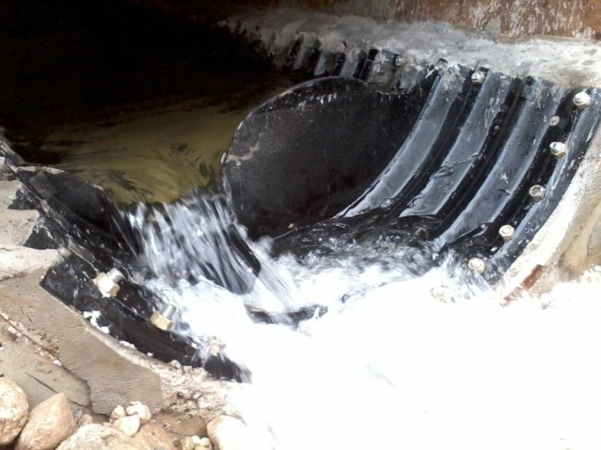
4 1.0 Introduction A concrete open footing culvert located on Ontario Ministry of Transportation (MTO) Highway 21 near Southampton, Ontario, and within the Saugeen First Nation Reserve #29 (see Appendix A), had reached the end of its service life and was in need of replacement. This culvert was perched above the streambed and restricted any upstream fish migration this has likely been the case since the highway and the culvert were constructed over seventy-five years ago (see Appendix B for pictures of the original culvert). This tributary to the Saugeen River supports a diverse range of coldwater fish species such as Rainbow Trout, and is culturally significant to the community as it is a popular area for fishing. Restoring fish passage upstream of the culvert location was a key objective of this project. The project team evaluated a number of alternative methods of replacing the culvert. One of the alternatives evaluated required a full closure of the highway to remove the original culvert and place a new culvert in the same location. Closing the two-lane section of road and detouring highway traffic would have had significant negative socioeconomic impacts on the First Nation community that relies on Highway 21 as the main road into and out of the Reserve. Through the environmental assessment process it was decided that the original culvert would be left in place, filled in with concrete and capped at both ends. A new culvert would be installed using a jack and bore trenchless technology, slightly to the east of the original culvert, allowing the highway above to remain open. Construction of the new culvert began in summer 2015 and was completed in late fall A steel pipe culvert was installed beneath the highway, and then a liner with attached fish baffles was slipped inside the pipe. Because the location of the new culvert was shifted slightly to the east of the original culvert, the watercourse at the inlet and outlet of the new culvert required a small shift in alignment. Fish habitat features were then incorporated into the new channel at the inlet and outlet. 2.0 Environmental Protection and Enhancement As part of the design and Class Environmental Assessment process, fisheries investigations were conducted upstream and downstream of the Highway 21 Craig Street Culvert. Prior to these assessments, little was known about the Saugeen River tributary. Following field investigations, the tributary downstream of the culvert was determined to be highly sensitive, providing diverse habitats which support a wide range of cool and cold water fish species. Access and spawning habitat for Rainbow Trout was evident by the high number of juvenile and young-of-year in the channel immediately downstream of the culvert, as well as a variety of more common species
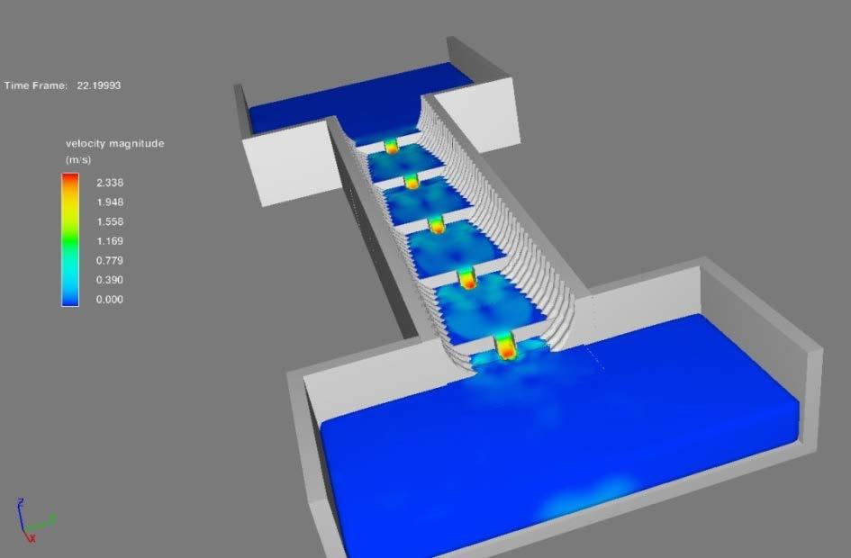
5 such as: Creek Chub, Northern Redbelly Dace, Brook Stickleback, Central Mudminnow, Black Bullhead, Bluntnose Minnow, and White Sucker. Upstream of the culvert, the tributary was also found to provide varied riffle/run/pool habitats extending through a well-defined riparian corridor of White Cedar and mixed hardwood vegetation. However, the field investigations did not identify any fish utilizing the upstream reach. The dramatic contrast between fisheries conditions in the tributary downstream and upstream of Highway 21 suggested that the passage and connectivity between the two stream segments was negatively impacted as a result of the original culvert structure. The barriers to fish were threefold: the culvert was perched approximately 1 m above the streambed; a shallow sheet flow of water passed through the culvert, causing a high velocity of water and insufficient depth for fish; and the culvert was located on an approximately 7% slope. Knowing that the culvert was restricting fish passage in this ecologically sensitive location, restoring fish passage and continuity of the aquatic habitats became a primary objective of the culvert replacement project. The new culvert was designed to include baffles and graduated pools to increase the potential for the native fish community to migrate to the upper reaches of the watercourse. The baffles were bolted to a corrugated liner that was then slipped inside the steel pipe culvert. The liner and baffles were coated with thermoplastic copolymer to increase their longevity and provide a smooth surface that would not injure fish. The new baffle design promotes slower water speeds with a meandering thalweg throughout the culvert. In addition, to allow upstream migration of smaller fish during periods of lower flows, a ramp/slide was added to the downstream side of each baffle. The corrugations in the liner aid in reducing water velocity and create areas for natural streambed substrates to settle, allowing for naturalization of the culvert channel over time (refer to Appendix C). The areas immediately adjacent to the inlet and the outlet of the culvert were restored with favourable fish habitat features such as fish refuge pools, to provide a resting area for fish after they ascend the culvert. During post-construction fisheries investigations in Spring and Summer of 2016, Rainbow Trout, White Sucker, and Creek Chub were found upstream of the culvert, confirming that the new culvert provides fish passage. Monitoring will continue in Spring and Summer 2017 to further assess the effectiveness of the culvert and ensure that the fluvial geomorphology of the channel is functioning as intended. By replacing the original culvert with a structure that eliminates the barriers to fish migration, and incorporating favourable fish habitat features in the tributary both upstream and downstream of the new culvert, fish will now be able to access the upstream segment of the watercourse, similar to the site conditions that existed prior to the construction of Highway 21. Sensitive fish species may now increase their range,
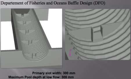
6 accessing reaches of the stream they have not been able to access for over seventyfive years. This will not only have a positive effect in restoring the ecological connectivity and increasing species diversity throughout the watercourse, but will also serve to expand the habitat of a valuable natural resource to the First Nations community. This project contributes to both the protection and enhancement of the environment and achieves a social and economic benefit, as it improved the quality of the upstream environment and maintained access to the community. 3.0 Innovation The project team working on this culvert replacement was quite diverse in their backgrounds and experience, and included MTO environmental and engineering staff, MMM Group Ltd. engineering staff, Parsons biologists, Aquafor Beech fluvial geomorphologists, and a representative from the Saugeen Ojibway Nation Environment Office, as well as the designer of the baffles, a modeller, and a representative for the liner constructor. The collaboration among such a diverse project team resulted in an innovative solution to a common problem. The MTO project team worked directly with the Corrugated Steel Pipe Institute (CSPI) and the designer of the baffles to utilize the Highway 21 site as a pilot project. The main feature of this new culvert is the fish ladder, or series of baffles, that is incorporated within it. The fish ladder is made up of a corrugated steel liner which has baffles bolted to it that are evenly spaced throughout the length of the culvert. The baffles are designed to slow the water flow and create fish refuge areas within the culvert. They also serve to reduce the accumulation of debris within the culvert, which can also act as a barrier to fish. It also includes a ramp/slide which assists the fish in swimming up the culvert from the downstream to the upstream end (refer to Appendix C). The baffle configuration and geometry was designed by Ken Hannaford of the Government of Newfoundland and Labrador, modelled by Jason Duguay of the University of Sherbrooke, and the liner was constructed by Armtec, a member of the Corrugated Steel Pipe Institute. This type of baffle system is an improvement over traditional baffles that have been used to assist fish in ascending sloped culverts, such as the Department of Fisheries and Oceans (DFO) baffle design (shown in Appendix D). This project site was selected to be a pilot project for the use of this innovative baffle design to solve the environmental issues with the original culvert. One of the challenges of providing for fish passage at this location was that the gradient of the culvert was quite steep at approximately 7%. This makes it difficult for fish to swim upstream due to gravity and the velocity of the water. Extensive modelling was conducted to ensure that the fish liner and baffle system could adequately slow the water such that the targeted
7 fish species would be able to swim upstream. Photographs of the construction and final results can be seen in Appendix E. Input from various ministries and agencies was sought throughout the design of the project. Since the most directly affected individuals were those living in the community, consultation with the Saugeen First Nation was done through a representative of the Saugeen Ojibway Nation (SON) Environment Office. MTO developed a positive working relationship with SON and together used innovative methods to communicate information about the project and to provide a contact within the community in case there were any questions or concerns throughout construction. An information brochure was posted on the Saugeen First Nation website with pertinent information about the project and included contact information. A sign was also placed near the culvert location in advance of construction which included a link to the website, directing interested persons to the information brochure (see Appendix E). Additionally, presentations were made to the Saugeen First Nation Council, where Council s input was received and incorporated into the project. In addition to working closely with SON throughout the design of the culvert and fish ladder, MTO initiated an Aboriginal Procurement Project to hire local SON community members to complete the pre-clearing of trees on-site prior to the start of construction of the culvert. Clearing the trees (in advance of the migratory bird nesting window, which typically begins around April 1 st in this area), was required in order to access the site for construction. The pre-clearing work was so successful that MTO is now working towards another Aboriginal Procurement Project for SON community members to complete some of the post-construction landscaping and restoration work at the site, consisting of planting trees, shrubs, and grasses that are native to the area. 4.0 Financial Implications A jack and bore trenchless method was used to install the new culvert beside the original culvert in order to avoid closing the road, which would have had a negative impact on the First Nations community and the travelling public. This method was estimated to cost approximately 10-15% less than the alternative, which was an opencut option. It is difficult to quantify the economic impact that a full closure would cause, however, the community relies on Highway 21 for transportation into and out of the Reserve. The closure of Highway 21 would impact residents and business owners, visitors, and anyone using Highway 21 as a through-route to access other communities. The Bruce Peninsula area is a popular summer tourist destination, and a road closure during this time would cause significant delays and increased traffic on the local roads. The Average Annual Daily Traffic using Highway 21 is approximately 4500 vehicles per day. Detour routes for traffic would have to be prepared, and a more extensive public
8 consultation plan would have to be developed and carried out if a full closure of Highway 21 was required. Utilizing the baffle system and liner within the culvert was an added expense to the ministry, since the traditional culvert replacement methods would generally not incorporate such a system. However, the benefits provided to the environment and the community for generations to come as a result of incorporating this system more than exceed the costs to install. It should be noted, however, that the CSPI provided the design and evaluation free of charge since this was a pilot project. 5.0 Applicability to Transportation Given the success experienced with this innovative baffle system, going forward, the ministry may install these baffles instead of the traditional baffle design in culverts with similar challenges and where improving fish passage is a key consideration. The project has garnered attention from other regions, and received an honourable mention from the Ontario Environmental Commissioner s ECO Recognition Award in February This successful culvert replacement project proves that outdated infrastructure can be replaced with more environmentally sustainable options, while at the same time reducing the overall cost of construction as compared to traditional methods. It is important that examples such as this are shared with the transportation community so that decision-makers are aware of the benefits that can be realized when an ecosystembased approach to planning and design is undertaken. It is a common misperception that environmentally-friendly alternatives are more costly, but in the case of long-lasting infrastructure, the benefits must be accounted for over its lifetime. When the environmental, social, and economic benefits that a project such as this provides are accounted for, they far outweigh the costs. 6.0 Conclusion The unique approach taken to community consultation, design, and construction of this culvert replacement has resulted in an improved outcome for the Ontario Ministry of Transportation. An added benefit resulting from the successful completion of this project is the relationship that the ministry has developed with the Saugeen First Nation and Saugeen Ojibway Nation, through the collaborative approach taken on this project. The knowledge of the local area that was shared was helpful in both the design and construction phases of the project. The project team has benefitted greatly from the knowledge shared amongst team members and experience gained, and will be able to apply this on future, similar projects. Furthermore, the Saugeen First Nation community
9 will benefit for generations to come, as the tributary to the Saugeen River re-establishes its natural ecosystem, and species diversity and habitat range is expanded.
10 Ontario Ministry of Transportation (MTO) Restoring Fish Passage to a Tributary of the Saugeen River 2017 Transportation Association of Canada Environmental Achievement Award Nomination Submission APPENDICES Prepared by: Kirstie Houston Environmental Planner Ontario Ministry of Transportation March 2017

11 APPENDIX A Location of the Highway 21 Craig St. Culvert


12 APPENDIX B Original Culvert


13 APPENDIX C Hannaford Baffle Design


14 APPENDIX D DFO Fish Baffle Design

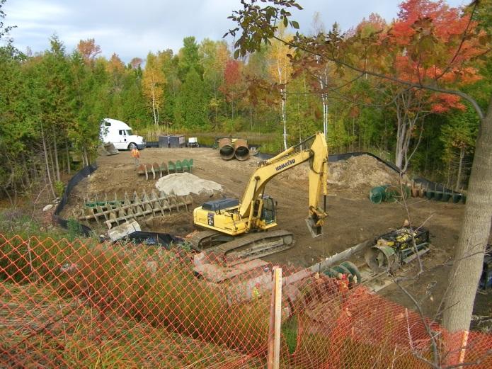

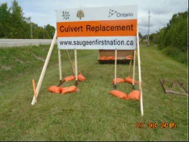

15 APPENDIX E Construction and Final Results
RESILIENT INFRASTRUCTURE June 1 4, 2016
 RESILIENT INFRASTRUCTURE June 1 4, 2016 FISH BARRIER MITIGATION OF AN OVERSTEEPENED CULVERT WITHIN SAUGEEN FIRST NATION RESERVE Robert A Amos Aquafor, Canada Courtney Beneteau Parsons, Canada Tisha Doucette
FINAL REPORT. Yonkers Creek Migration Barrier Removal Project Wonderstump Road Del Norte County. Submitted By:
 FINAL REPORT Yonkers Creek Migration Barrier Removal Project Wonderstump Road Del Norte County Submitted By: Del Norte County Community Development Department Yonkers Creek Migration Barrier Removal Project
COA-F17-F-1343 YEAR END REPORT
 DAVE MARSHALL SALMON RESERVE RESTORATION, MAINTENANCE, AND UPGRADES YEAR END REPORT Prepared for: Fish and Wildlife Compensation Program Prepared by: Edith Tobe, RPBio, Executive Director Box 1791, Squamish,
Removal of natural obstructions to improve Atlantic Salmon and Brook Trout habitat in western NL. 26/02/2015 Version 2.0
 Removal of natural obstructions to improve Atlantic Salmon and Brook Trout habitat in western NL 26/02/2015 Version 2.0 1 Table of Contents List of Tables... 2 Introduction... 3 Methods... 4 Preliminary
Report prepared for: Prepared by: January 2002 BEAK Ref
 AQUATIC ENVIRONMENTAL STUDY KANATA WEST CONCEPT PLAN Report prepared for: ROBINSON CONSULTANTS Prepared by: BEAK INTERNATIONAL INCORPORATED 14 Abacus Road Brampton, Ontario L6T 5B7 January 2002 BEAK Ref.
Five Counties Salmonid Conservation Program - Fish Passage Design Workshop. February 2013
 Program - Aquatic Organisms and Stream Crossings Ecological Connectivity A watershed is a network of channels that drain a common boundary. Channel characteristics formed by interaction of precipitation,
Presented by Fred Halterman, URS Jennie Agerton, URS
 Presented by Fred Halterman, URS Jennie Agerton, URS What is Eco Friendly Culvert Design? Culvert design that: Maintains connectivity for aquatic organism migration Maintains connectivity for gene flow
Understanding the Impacts of Culvert Performance on Stream Health
 Understanding the Impacts of Culvert Performance on Stream Health Kristin Thomas Aquatic Ecologist Michigan Trout Unlimited Transportation and the Environment Conference 12/5/2018 Importance of adequately
Fish Passage Culvert Assessment for Cahilty Creek Watershed FIA Project #
 Fish Passage Culvert Assessment for Cahilty Creek Watershed FIA Project # 4602004 Prepared for Weyerhaeuser Company Ltd. Jason Ladyman R.P.F. 1550 Mission Flats Road PO Box 40 Kamloops BC V2C 5K3 Prepared
Eastern Brook Trout Joint Venture Annual Report The Nature Conservancy 2013
 Eastern Brook Trout Joint Venture Annual Report The Nature Conservancy 2013 2013 Annual Performance Report Enhancing Connectivity in the Ash-Black Rock Sub-basin of the West Branch Narraguagus River. Project
Big Spring Creek Habitat Enhancement and Fishery Management Plans
 Big Spring Creek Habitat Enhancement and Fishery Management Plans November 5, 2012 Big Spring Events and Activities Center Newville, PA Charlie McGarrell Regional Habitat Biologist Pennsylvania Fish and
Alberta Conservation Association 2017/18 Project Summary Report
 Alberta Conservation Association 2017/18 Project Summary Report Project Name: Abundance, Distribution, Spawning, and Thermal Habitat of Westslope Cutthroat Trout and Bull Trout in the Stimson Creek Watershed
Appendix A Photo Set
 Appendix A Photo Set Fish Habitat Inventory, Mattamy Richmond Lands, Spring 2009 Submitted To: Susan Murphy Mattamy Homes 123 Huntmar Drive Ottawa, Ontario K2S 1B9 KILGOUR & ASSOCIATES LTD. 1500 Bank Street,
SELBY CREEK SILVERADO TRAIL CULVERT FISH PASSAGE ASSESSMENT
 SELBY CREEK SILVERADO TRAIL CULVERT FISH PASSAGE ASSESSMENT NAPA COUNTY, CALIFORNIA PREPARED BY NAPA COUNTY RESOURCE CONSERVATION DISTRICT 1303 JEFFERSON ST. SUITE 500B NAPA, CALIFORNIA 94559 WWW.NAPARCD.ORG
Annual Report for Fiscal Year and Future Plans for the Tillamook Bay Watershed Council
 Annual Report for Fiscal Year 2012-2013 and Future Plans for the Tillamook Bay Watershed Council A report prepared for the Tillamook County Board of Commissioners August 2013 Table of Contents: Recently
Okanagan Sockeye Reintroduction
 Okanagan Sockeye Reintroduction Backgrounder Elders accounts, and other forms of Traditional Ecological Knowledge (TEK) tell us that many species of salmon once came into the Okanagan Valley and tell us
Stream Crossings I: Engineering and Design Approaches to Provide Fish Passage at Culvert Slipline Projects in Connecticut
 University of Massachusetts - Amherst ScholarWorks@UMass Amherst International Conference on Engineering and Ecohydrology for Fish Passage International Conference on Engineering and Ecohydrology for Fish
Cold-transitional Stream
 Cold-transitional Stream A Brief Ecological Description of this Michigan River Type Cold-transitional Stream segments are defined (by the Michigan Department of Natural Resources, Fisheries Division) as
Holderness. The Three Watersheds within the Newfound Lake Drainage Dorchester. Groton Plymouth. Ashland. Hebron. Canaan. Bridgewater.
 Background Brook trout are the only native stream dwelling trout species in New Hampshire, having a historic range that extended from Georgia to eastern Canada. It is believed that wild brook trout were
7 8 Mahogany Creek views downstream and upstream along creek corridor from Manotick Main Street (1, 2), Bridgeport Avenue (3, 4) and Century Road
, Bridgeport Avenue (3, 4) and Century Road") Appendix B Photos 1 2 3 4 5 6 7 8 Mahogany Creek views downstream and upstream along creek corridor from Manotick Main Street (1, 2), Bridgeport Avenue (3, 4) and Century Road East (5, 6). Storm sewer
Appendix B Photos 1 2 3 4 5 6 7 8 Mahogany Creek views downstream and upstream along creek corridor from Manotick Main Street (1, 2), Bridgeport Avenue (3, 4) and Century Road East (5, 6). Storm sewer
Session B5 - Culvert Roughness Elements for Native Utah Fish Passage
 University of Massachusetts - Amherst ScholarWorks@UMass Amherst International Conference on Engineering and Ecohydrology for Fish Passage International Conference on Engineering and Ecohydrology for Fish
Oregon Department of Transportation (ODOT) Culvert Repair Fish Passage Pilot Programmatic Agreement Final ODFW Report
 Culvert Repair Fish Passage Pilot Programmatic Agreement Final ODFW Report") Oregon Department of Transportation (ODOT) Culvert Repair Fish Passage Pilot Programmatic Agreement 2014-17 Final ODFW Report Prepared by Pete Baki June 27, 2018 Table of Contents 1 Background 4 Culvert
Oregon Department of Transportation (ODOT) Culvert Repair Fish Passage Pilot Programmatic Agreement 2014-17 Final ODFW Report Prepared by Pete Baki June 27, 2018 Table of Contents 1 Background 4 Culvert
Ecological gains through EIA in Parks Canada
 Ecological gains through EIA in Parks Canada Eric Tremblay, Park Ecologist, Kouchibouguac National Park, NB, Canada April 6 th, 2017 1 Integrating SARA and Fisheries Act Aboriginal consultations 2 Kouchibouguac
Discussion on the Selection of the Recommended Fish Passage Design Discharge
 Discussion on the Selection of the Recommended Fish Passage Design Discharge Introduction The provision of fish passage is a requirement for most proposed culvert and bridge installations in Alberta, depending
Creation of Fish and Wildlife Habitat on the Closed Salmon Harbour Mine in Minto, NB
 Creation of Fish and Wildlife Habitat on the Closed Salmon Harbour Mine in Minto, NB M. Coleman 1, R. Rutherford 2, RA Currie 3 1 NB Power 2 Thaumas Environmental Consultants Ltd 3 RA Currie Ltd. Location
Stream Simulation Design of Conn Creek Culvert
 Stream Simulation Design of Conn Creek Culvert Zichao Wu, Ph.D., P.Eng., PE, AECOM James P. Harrison, Ph.D., Fisheries Scientist, Stantec Paper prepared for presentation at Session (2): Bridges - Innovations
Applying Engineering Solutions to the Science of Protection and Enhancement of Aquatic Environments. Bill Holman, P.E. Stanley Consultants
 Applying Engineering Solutions to the Science of Protection and Enhancement of Aquatic Environments Bill Holman, P.E. Stanley Consultants Project Development PHASE STAGE TASKS PURPOSE I II III Investigation
ADOPT-A-STREAM WATERSHED APPROACH COMMUNITY-BASED STEWARDSHIP. Nova Scotia Salmon Association March 2005
 ADOPT-A-STREAM A WATERSHED APPROACH TO COMMUNITY-BASED STEWARDSHIP Nova Scotia Salmon Association March 2005 This manual is a revised and updated version of the 1994 Adopt-a-Stream manual that was prepared
BC Ministry of Forests. March Fish Stream Crossing Guidebook. Forest Practices Code of British Columbia.
 FRST 557 Lecture 7c Bridges and Culverts: Water Velocity and Discharge Lesson Background and Overview: The previous two lessons presented methods for estimating water volume flow at a particular site and
Aquatic Organism Passage at Road-Stream Crossings CHUCK KEEPORTS FOREST HYDROLOGIST ALLEGHENY NATIONAL FOREST WARREN, PENNSYLVANIA
 Aquatic Organism Passage at Road-Stream Crossings CHUCK KEEPORTS FOREST HYDROLOGIST ALLEGHENY NATIONAL FOREST WARREN, PENNSYLVANIA TOPICS COVERED Aquatic Organism Passage (AOP) Benefits of AOP Crossings
CHAPTER 4 DESIRED OUTCOMES: VISION, GOALS, AND OBJECTIVES
 CHAPTER 4 DESIRED OUTCOMES: VISION, GOALS, AND OBJECTIVES Vision One of the first steps in developing this Plan was articulating a vision - a clear statement of what the Plan strives to achieve and what
Thunder Bay River Assessment Appendix. Appendix 2
 Appendix 2 Known past and present fish distributions in the River system. Distribution of fishes were compiled from Bailey et al. (2003) and from records located at the Michigan Department of Natural Resources
Waikanae River Environmental Strategy. 12. Arapawaiti/Otaihanga Reach
 74 Waikanae River Environmental Strategy 12. Arapawaiti/Otaihanga Reach Figure 12: Arapawaiti/Otaihanga Reach 75 PART C: Protecting and Improving the River Corridor / Arapawaiti/Otaihanga Reach Waikanae
OKANAGAN RIVER RESTORATION INITIATIVE - FAQ
 OKANAGAN RIVER RESTORATION INITIATIVE - FAQ Initiative background: The health of the q awsitk w (Okanagan River) has been severely impacted by the channelization works that occurred in the mid-1950 s.
Assessing Ecosystem Impacts from Road Stream Crossings through Community Involvement
 Assessing Ecosystem Impacts from Road Stream Crossings through Community Involvement Background Why is the NH Fish and Game Department interested in culverts? Block fish migration Reduce opportunities
JAP Additional Information Sheet
 JAP Additional Information Sheet Block 15: Purpose and Need The USACE purpose of the project is to provide a safe and reliable whitewater park for the recreational public in a city park, which will provide
STREAM SURVEY File form No..
 scanned for KRIS THE RESOURCES AGENCY OF CALIFORNIA California Department of Fish and Game STREAM SURVEY File form No.. Date: September 4, 1969. NAME: North Fork Schooner Gulch Creek COUNTY: Mendocino.
Restoring the Kootenai: A Tribal Approach to Restoration of a Large River in Idaho
 Restoring the Kootenai: A Tribal Approach to Restoration of a Large River in Idaho Susan Ireland, Kootenai Tribe of Idaho Future of our Salmon Conference Technical Session August 2016 Healthy Floodplains,
Cold-transitional Small River
 Cold-transitional Small River A Brief Ecological Description of this Michigan River Type Cold-transitional Small River segments are defined (by the Michigan Department of Natural Resources, Fisheries Division)
Study Update Fish Distribution and Species Composition
 Study Update Fish Distribution and Species Composition Goals and Study Area Gain a better understanding of fish species composition and abundance in waters associated with the Packwood Lake Hydroelectric
Methods for Evaluating Shallow Water Habitat Restoration in the St. Clair River
 Methods for Evaluating Shallow Water Habitat Restoration in the St. Clair River Objectives Document fish use of restoration sites Spawning Presence of larvae, juvenile, and adult fish Quantify differences
Climate Change Adaptation and Stream Restoration. Jack Williams;
 Climate Change Adaptation and Stream Restoration Jack Williams; jwilliams@tu.org 1 Goals for this presentation Develop strategies for adapting streams to climate impacts by Thinking like a watershed Understanding
Eastern Brook Trout. Roadmap to
 Eastern Brook Trout Roadmap to CONSERVATION Our Brook Trout heritage he wild Brook Trout is an American symbol of persistence, adaptability, and the pristine wilderness that covered North America prior
Black Sturgeon Regional Plan
 Black Sturgeon Regional Plan This is one of twenty Regional Plans that support implementation of the Lake Superior Biodiversity Conservation Strategy (Strategy). The Strategy, prepared and overseen by
NEVADA DEPARTMENT OF WILDLIFE STATEWIDE FISHERIES MANAGEMENT
 NEVADA DEPARTMENT OF WILDLIFE STATEWIDE FISHERIES MANAGEMENT FEDERAL AID JOB PROGRESS REPORTS F-20-52 2016 Lake Tahoe Rainbow Trout Study WESTERN REGION NEVADA DEPARTMENT OF WILDLIFE, FISHERIES DIVISION
FISH PASSAGE IMPROVEMENT in California s Watersheds. Assessments & Recommendations by the Fish Passage Forum
 FISH PASSAGE IMPROVEMENT in California s Watersheds Assessments & Recommendations by the Fish Passage Forum FISH PASSAGE IMPROVEMENT in California s Watersheds The mission of the Fish Passage Forum is
Minnesota Department of Natural Resources Division of Fish and Wildlife Section of Fisheries. Stream Survey Report. Cold Spring Creek.
 Minnesota F-29-R(P)-24 Area 315 Study 3 March 2015 Minnesota Department of Natural Resources Division of Fish and Wildlife Section of Fisheries Stream Survey Report Cold Spring Creek 2014 Mark Pelham Montrose
CALIFORNIA SALMONID STREAM HABITAT RESTORATION MANUAL APPENDIX IX-A CULVERT CRITERIA FOR FISH PASSAGE INTRODUCTION
 APPENDIX IX-A STATE OF CALIFORNIA RESOURCES AGENCY DEPARTMENT OF FISH AND GAME CULVERT CRITERIA FOR FISH PASSAGE For habitat protection, ecological connectivity should be a goal of stream-road crossing
FISHERIES BLUE MOUNTAINS ADAPTATION PARTNERSHIP
 FISHERIES A warming climate, by itself, substantially affects the hydrology of watersheds in the Blue Mountains. Among the key hydrologic changes projected under all scenarios for the 2040s and beyond
SUMMARY REPORT FOR LAKE ST. MALO FISHERIES ASSESSMENT. Prepared for the St. Malo and District Wildlife Association
 SUMMARY REPORT FOR LAKE ST. MALO FISHERIES ASSESSMENT Prepared for the St. Malo and District Wildlife Association Presented by August 25, 2014 Study dates thus far: Date Tasks February 16 Fishing derby;
Minnesota Department of Natural Resources Division of Fish and Wildlife Section of Fisheries. Stream Survey Report. Cold Spring Creek.
 Minnesota F-29-R(P)-24 Area 315 Study 3 March 2013 Minnesota Department of Natural Resources Division of Fish and Wildlife Section of Fisheries Stream Survey Report Cold Spring Creek 2012 Mark Pelham Montrose
Fish Community. Fish Habitat, Streams and Rivers
 Clear, Ston(e)y and White Lake Plan Fish Community The lakes support a cool/warm water fishery including muskellunge, walleye, largemouth and smallmouth bass, yellow perch, pumpkinseed, rockbass, blue
Massachusetts Stream Crossing Case Studies
 Massachusetts Stream Crossing Case Studies Amy Singler Associate Director, River Restoration Program Carrie Banks River Continuity Coordinator Case Studies: Public Benefits: Movement of goods and people
Illinois Lake Management Association Conference March 23, 2018 By Trent Thomas Illinois Department of Natural Resources Division of Fisheries
 Illinois Lake Management Association Conference March 23, 2018 By Trent Thomas Illinois Department of Natural Resources Division of Fisheries Sources of Habitat Impairment Sedimentation Channelization
Minnesota Department of Natural Resources Division of Fish and Wildlife Section of Fisheries. Stream Survey Report. Three Mile Creek 2011
 Minnesota Department of Natural Resources Division of Fish and Wildlife Section of Fisheries Stream Survey Report Three Mile Creek 2011 By Joseph D. Stewig Montrose Area Fisheries Office TABLE OF CONTENTS
Vermont. Vermont Fish & Wildlife Department 1 National Life Drive Montpelier, VT
 Vermont Stream Crossing Vermont Fish & Wildlife Department 1 National Life Drive Montpelier, VT 05620-3702 802-828-1000 www.vtfishandwildlife.com Handbook Introduction Vermonters have always strongly connected
NEVADA DEPARTMENT OF WILDLIFE STATEWIDE FISHERIES MANAGEMENT
 NEVADA DEPARTMENT OF WILDLIFE STATEWIDE FISHERIES MANAGEMENT FEDERAL AID JOB PROGRESS REPORTS F-20-52 2016 LAKE TAHOE WESTERN REGION NEVADA DEPARTMENT OF WILDLIFE, FISHERIES DIVISION ANNUAL PROGRESS REPORT
Trout Unlimited Comments on the Scope of Environmental Impact Statement for the Constitution Pipeline Project, Docket No. PF12-9
 October 9, 2012 Kimberly D. Bose, Secretary Federal Energy Regulatory Commission 888 First Street, NE, Room 1A Washington, DC 20426 RE: Trout Unlimited Comments on the Scope of Environmental Impact Statement
FISHERIES MANAGEMENT PLAN FOR DUFFINS CREEK AND CARRUTHERS CREEK JUNE, 2004
 FISHERIES MANAGEMENT PLAN FOR DUFFINS CREEK AND CARRUTHERS CREEK JUNE, 2004 Toronto and Region Conservation 2004 ISBN0-9732764-0-1 www.trca.on.ca 5 Shoreham Drive, Toronto, Ontario M3N 1S4 phone: 416-661-6600
FACT SHEET MCGREGOR LAKE RESTORATION HABITAT PROJECT POOL 10, UPPER MISSISSIPPI RIVER, WISCONSIN ENVIRONMENTAL MANAGEMENT PROGRAM
 FACT SHEET MCGREGOR LAKE RESTORATION HABITAT PROJECT POOL 10, UPPER MISSISSIPPI RIVER, WISCONSIN ENVIRONMENTAL MANAGEMENT PROGRAM LOCATION McGregor Lake is located within a mid-river island in Pool 10
Simulating Streams Through Culverts in Mat-Su, Alaska
 Simulating Streams Through Culverts in Mat-Su, Alaska Project Managers Bill Rice, P.E., USFWS Hydrologist Mary Price, USFWS Fishery Biologist The Team Approach US Fish and Wildlife Service Bill Rice, P.E.,
PROJECT TO INSTALL LARGE WOOD HABITAT STRUCTURES IN THE CARMEL RIVER USING CALIFORNIA DEPARTMENT OF FISH AND GAME GRANT FUNDS
 PROJECT TO INSTALL LARGE WOOD HABITAT STRUCTURES IN THE CARMEL RIVER USING CALIFORNIA DEPARTMENT OF FISH AND GAME GRANT FUNDS The Monterey Peninsula Water Management District (MPWMD), in cooperation with
Juvenile Steelhead and Stream Habitat Conditions Steelhead and Coho Salmon Life History Prepared by: DW ALLEY & Associates, Fishery Consultant
 Juvenile Steelhead and Stream Habitat Conditions Steelhead and Coho Salmon Life History Prepared by: DW ALLEY & Associates, Fishery Consultant I-1. Steelhead and Coho Salmon Ecology Migration. Adult steelhead
Wisconsin s Citizen-Based Monitoring Partnership Program and Trout Unlimited Driftless Area Restoration Effort (TUDARE)
") Wisconsin s 2010-11 Citizen-Based Monitoring Partnership Program and Trout Unlimited Driftless Area Restoration Effort (TUDARE) TUDARE Stream Monitoring Sites Established in 2010-2011 Summary Prepared
Wisconsin s 2010-11 Citizen-Based Monitoring Partnership Program and Trout Unlimited Driftless Area Restoration Effort (TUDARE) TUDARE Stream Monitoring Sites Established in 2010-2011 Summary Prepared
Project Completion Abstract Fish Passage Activity ( Engineering Activities)
") Project Completion Abstract Fish Passage Activity ( Engineering Activities) SUBMIT COMPLETED FORM TO DISTRICT MANAGER AND FIA ADMINISTRATOR AFTER PROJECT COMPLETION SECTION A GENERAL INFORMATION Recipient:
Project Completion Abstract Fish Passage Activity ( Engineering Activities) SUBMIT COMPLETED FORM TO DISTRICT MANAGER AND FIA ADMINISTRATOR AFTER PROJECT COMPLETION SECTION A GENERAL INFORMATION Recipient:
STEELHEAD SURVEYS IN OMAK CREEK
 STEELHEAD SURVEYS IN OMAK CREEK 2002 Annual Report Prepared by Chris Fisher John Arterburn Colville Confederated Tribes Fish and Wildlife Department P.O. Box 150 Nespelem, WA 99155 Prepared for Project
Cool (or Warm-transitional) Stream
 Stream") Cool (or Warm-transitional) Stream A Brief Ecological Description of this Michigan River Type Cool Stream segments are defined (by the Michigan Department of Natural Resources, Fisheries Division) as typically
Cool (or Warm-transitional) Stream A Brief Ecological Description of this Michigan River Type Cool Stream segments are defined (by the Michigan Department of Natural Resources, Fisheries Division) as typically
Alewife Brook, Cape Elizabeth, River Herring Monitoring Summary 2015
 University of Southern Maine USM Digital Commons Publications Casco Bay Estuary Partnership (CBEP) 2-3-2016 Alewife Brook, Cape Elizabeth, River Herring Monitoring Summary 2015 Matt Craig University of
Michigan Department of Natural Resources Status of the Fishery Resource Report Page 1
 Michigan Department of Natural Resources 2008-59 Status of the Fishery Resource Report Page 1 Bowens Manistee County, (T24N R16W Sec. 11, 12, 13, 14, 15, 24, and 30). Last surveyed 2008 Mark A. Tonello
(Revised February,2005) CULVERTS, BRIDGES, AND FORDS
 CULVERTS, BRIDGES, AND FORDS") GUIDE TO STREAM CROSSINGS (Revised February,2005) CULVERTS, BRIDGES, AND FORDS Culverts, bridges, and fords are all methods used to cross-streams. Culverts are the most common stream crossing structure.
GUIDE TO STREAM CROSSINGS (Revised February,2005) CULVERTS, BRIDGES, AND FORDS Culverts, bridges, and fords are all methods used to cross-streams. Culverts are the most common stream crossing structure.
Kootenai River Habitat Restoration Program. Kootenai Tribe of Idaho - January 27, 2014 Presentation for Kootenai Valley Resource Initiative
 Kootenai River Habitat Restoration Program Kootenai Tribe of Idaho - January 27, 2014 Presentation for Kootenai Valley Resource Initiative Decline of native species Kootenai River White Sturgeon ENDANGERED
Cornwell brook Cornwell Manor
 Cornwell brook Cornwell Manor An Advisory Visit by the Wild Trout Trust February 2014 1 1. Introduction This report is the output of a Wild Trout Trust visit to a tributary of the Cornwell Brook at Cornwell
Swimming against the tide gates. Paul Franklin
 Swimming against the tide gates Paul Franklin Introduction Flood & tide gates used worldwide Act as physical barriers Modify aquatic environment Impact on aquatic communities What are tide gates? How do
Fish Survey Report and Stocking Advice for Loch Milton. (Loch a Mhuilinn), May 2011
, May 2011") Fish Survey Report and Stocking Advice for Loch Milton (Loch a Mhuilinn), May 2011 Jonah Tosney Freshwater Fisheries Biologist Wester Ross Fisheries Trust 1 Loch Milton (Loch a Mhuilinn) Fish Survey Report
Fish Survey Report and Stocking Advice for Loch Milton (Loch a Mhuilinn), May 2011 Jonah Tosney Freshwater Fisheries Biologist Wester Ross Fisheries Trust 1 Loch Milton (Loch a Mhuilinn) Fish Survey Report
6TH PELLETIER BROOK LAKE T15 R9, Aroostook Co. U.S.G.S. Gardner Pond, Maine (7 1/2 )
") 6TH PELLETIER BROOK LAKE T15 R9, Aroostook Co. U.S.G.S. Gardner Pond, Maine (7 1/2 ) Fishes Brook trout Minnows Blacknose dace Pearl dace Physical Characteristics Area - 27 acres Average depth - 2 feet
6TH PELLETIER BROOK LAKE T15 R9, Aroostook Co. U.S.G.S. Gardner Pond, Maine (7 1/2 ) Fishes Brook trout Minnows Blacknose dace Pearl dace Physical Characteristics Area - 27 acres Average depth - 2 feet
Fish Migration Barrier Severity and Steelhead Habitat Quality in the Malibu Creek Watershed
 Fish Migration Barrier Severity and Steelhead Habitat Quality in the Malibu Creek Watershed Produced for California State Coastal Conservancy and California Department of Parks and Recreation By: Heal
Rehabilitation of Grimes Creek, a Stream Impacted in the Past by Bucket-lined Dredge Gold Mining, Boise River Drainage, July 2008 to August 2011.
 Rehabilitation of Grimes Creek, a Stream Impacted in the Past by Bucket-lined Dredge Gold Mining, Boise River Drainage, July 2008 to August 2011. Pam Harrington TU,1020 W. Main Street Suite 440, Boise,
Benchmark Statement Respecting the Fish, Fish Habitat and Fisheries of Fish and Little Fish Lake, within the Taseko River Watershed.
 Benchmark Statement Respecting the Fish, Fish Habitat and Fisheries of Fish and Little Fish Lake, within the Taseko River Watershed. Information Supporting the Environmental Assessment of the Prosperity
HEC 26 Aquatic Organism Passage Design Manual Evolution & Application
 HEC 26 Aquatic Organism Passage Design Manual Evolution & Application Sven Leon, P.E., Hydraulics Engineer Federal Highway Administration 2015 Alaska Fish Passage Meeting October 13 14, 2015 VTRC, Juneau,
HURON RIVER WATERSHED
 Brown bullhead (Ameiurus nebulosus) feeding - larger streams and rivers, lakes and impoundments - clear cool water with little clayey silt - moderate amounts of aquatic vegetation - sand, gravel, or muck
EXTENT OF OBSERVATION
 scanned for KRIS THE RESOURCES AGENCY OF CALIFORNIA Department of Fish and Game STREAM SURVEY Date: May 25 and 31, 1977. NAME: Unnamed Stream (Tributary to Sonoma Creek) COUNTY: Sonoma. STREAM SECTION:
Study Update Tailrace Slough Use by Anadromous Salmonids
 Study Update Tailrace Slough Use by Anadromous Salmonids Goals and Objectives Identify what anadromous salmonids use the tailrace slough by: Life Stage (Juvenile, migrating and spawning adults) Timing
Executive Summary. Map 1. The Santa Clara River watershed with topography.
 Santa Clara River Steelhead Trout: Assessment and Recovery Opportunities December 2005 Prepared By: Matt Stoecker and Elise Kelley, Ph.D. University of California, Santa Barbara Prepared For: The Santa
First Nations Fish Habitat Program Discussion Workbook
 First Nations Fish Habitat Program Discussion Workbook The First Nations Fish Habitat Program is a joint initiative of the Centre for Indigenous Environmental Resources (CIER) and The Southern Chiefs Organization
Lake Superior. Ontonagon River Assessment. Ontonagon. Rockland. Victoria Dam. Bergland. Bergland. Dam. Bruce Crossing Agate Falls. Kenton Lower.
 Sand shiner otropis stramineus feeding - sand and gravel substrate - shallow pools in medium size streams, lakes, and impoundments - clear water and low gradient - rooted aquatic vegetation preferred -
Columbia Lake Dam Removal Project
 Columbia Lake Dam Removal Project The Columbia Lake dam located 1/4 mile upstream of the Paulins Kill River's confluence with the Delaware River in Knowlton Township, Warren County has been proposed for
Brook Trout Life Cycle and Habitat
 Brook Trout Life Cycle and Habitat Directions: 1. As you watch this slide show, watch for vocabulary terms we learned today. The first time they appear, you will see them in RED! (not redd!) 2. At the
SA New Trial Artificial Reef Project
 BACKGROUND PAPER SA New Trial Artificial Reef Project Development of options for the trial artificial reef 1. Summary CONTENTS Each year, an estimated 236,000 South Australians participate in recreational
PROJECT TITLE. Leadmine Brook Fish Passage and Habitat Restoration Project. NFHAP funding requested: $50,000
 Page1 PROJECT TITLE Leadmine Brook Fish Passage and Habitat Restoration Project NFHAP funding requested: $50,000 Project Location: (Connecticut, Windham, Ashford) Congressional District: 2nd APPLICANT:
Chadbourne Dam Repair and Fish Barrier
 Chadbourne Dam Repair and Fish Barrier Final Report for the Western Native Trout Initiative Prepared by: Carol Endicott Yellowstone Cutthroat Trout Conservation Biologist Montana Fish, Wildlife & Parks
San Lorenzo Valley Water District, Watershed Management Plan, Final Version Part I: Existing Conditions Report
 LIST OF FIGURES Figure 1-1. Map of the San Lorenzo River watershed Figure 2-1. The Santa Cruz Mountains Bioregion Figure 2-2. Protected areas within the San Lorenzo River watershed Figure 2-3. Primary
APPENDIX 3. Distribution Maps of Fish Species
 APPENDIX 3 Distribution Maps of Fish Species This appendix contains maps of known past and present fish distributions within the Manistique River watershed. The distributions of fish species were compiled
Site 4 PEESHOO. Approx. Head = 10 m Design Flow = 70 m 3 /s Capacity = 6 MW. Peeshoo. Kabinakagami River. Rogers Road HWY 11.
 Kabinakagami River Site 4 PEESHOO Rogers Road Peeshoo Approx. Head = 10 m Design Flow = 70 m 3 /s Capacity = 6 MW N 0 2 4 6 HWY 11 Kilometers Site 4 - PEESHOO Looking Downstream Looking Downstream Site
Ecology of Columbia River redband trout (Oncorhynchus mykiss gairdneri) in high desert streams
 in high desert streams") Ecology of Columbia River redband trout (Oncorhynchus mykiss gairdneri) in high desert streams Dry Creek October 2012 Chris A. Walser Ph.D., Professor of Biology Department of Biology and Environmental
Ecology of Columbia River redband trout (Oncorhynchus mykiss gairdneri) in high desert streams Dry Creek October 2012 Chris A. Walser Ph.D., Professor of Biology Department of Biology and Environmental
Fish Passage Design Aids Wildlife Crossing in Washington State State of the Practice
 Fish Passage Design Aids Wildlife Crossing in Washington State State of the Practice 0 Submission date: November, 0 Word Count:, Jon Peterson, corresponding author (0-0-, peterjn@wsdot.wa.gov) Fish Passage
FSOC Upstream Fish Passage Guidance Document
 FSOC Upstream Fish Passage Guidance Document STEP 1: Identify species and life stages in need of fish passage STEP 2: Identify fishway options and species applicability STEP 3 Fish passage criteria review
5B. Management of invasive species in the Cosumnes and Mokelumne River Basins
 5B. Management of invasive species in the Cosumnes and Mokelumne River Basins Cosumnes River The Cosumnes River basin has a number of distinct habitat types that require different management strategies
Firth Creek Habitat Enhancement Project 1993
 Firth Creek Habitat Enhancement Project 1993 A. R. Langston December 1993 PWFWCP Report No. 77 The Peace/Williston Fish & Wildlife Compensation Program is a cooperative venture of BC Hydro and the provincial
Little Kern Golden Trout Status:
 Little Kern Golden Trout Status: The Little Kern Golden trout (LKGT) was proposed for federal listing as Threatened under the Endangered Species Act (ESA) on September 1, 1977 by the U. S. Fish and Wildlife
Cold Small River. A Brief Ecological Description of this Michigan River Type
 Cold Small River A Brief Ecological Description of this Michigan River Type Cold Small River segments are defined (by the Michigan Department of Natural Resources, Fisheries Division) as typically having