SETTLEMENT AGREEMENT
|
|
|
- Christine Lyons
- 6 years ago
- Views:
Transcription
1 SETTLEMENT AGREEMENT AMONG PACIFICORP USDA FOREST SERVICE NATIONAL MARINE FISHERIES SERVICE USDI FISH & WILDLIFE SERVICE USDI BUREAU OF LAND MANAGEMENT OREGON DEPARTMENT OF ENVIRONMENTAL QUALITY OREGON DEPARTMENT OF FISH AND WILDLIFE OREGON WATER RESOURCES DEPARTMENT DATED JUNE 13, 2001 CONCERNING THE RELICENSING OF THE NORTH UMPQUA HYDROELECTRIC PROJECT FERC PROJECT NO DOUGLAS COUNTY OREGON Portlnd
2 TABLE OF CONTENTS Page SECTION 1. PURPOSE AND EFFECT OF THIS AGREEMENT Purpose of Agreement Section 18 of the FPA Fishway Prescriptions Section 4(e) of the FPA Section 10(j) Federal and State Fish and Wildlife Agency Recommendations State Fish Passage Law Threatened and Endangered Species Water Quality Certification PacifiCorp s Undertakings ODEQ s Undertakings Joint Undertakings Reservations Water Right Issuance NEPA Analysis NFMA and NFP Wild and Scenic Rivers Act Section 7(a) Determination Limitations Representations Regarding Consistency and Compliance with Statutory Obligations Conditions Precedent and Conditions Subsequent License Term...13 SECTION 2. ACTIONS UPON EXECUTION OF THIS AGREEMENT FERC Filings Permits Communications with FERC and Other Government Agencies Timing of Obligations...14 SECTION 3. MANAGEMENT GOALS Fluvial Geomorphic Processes Aquatic and Riparian Habitat Connectivity In-Stream Flows Reservoir and Forebay Management Water Quality Anadromous Fish Passage and Off-Site Mitigation Terrestrial Species Connectivity and Wildlife Entrapment...15 SECTION 4. FISH PASSAGE MEASURES Fish Passage at Soda Springs Dam Upstream Fish Passage Portlnd
3 North Umpqua Settlement Agreement Downstream Passage at Soda Springs Dam Fish Passage at Slide Creek Dam Fish Passage at Diversions Upstream of Toketee Falls and Fish Creek Upstream Fish Passage Downstream Fish Passage Toketee Reservoir Other Project Diversions...21 SECTION 5. IN-STREAM FLOWS FOR FISH AND OTHER AQUATIC SPECIES In-Stream Flow Implementation In-Stream Flow Reevaluation Modifications to In-Stream Flows Lemolo 2 Reach In-Stream Flow Monitoring ODFW Holding Ponds Fish Passage Soda Springs Dam Toketee Bypass Reach...22 SECTION 6. RAMPING Lemolo 2 Full-Flow Reach Impact Analysis of Pipe to Stinkhole Slide Creek Full-Flow Reach Monitoring Plan Flow Regulation Toketee Full-Flow Reach Wild and Scenic River Reach Below Soda Springs Powerhouse Flows Below 1,600 cfs Flows Above 1,600 cfs Ramping Study Record of Stage Changes Management of Natural Flow Events and Lemolo Draft or Refill Ramping in Bypass Reaches Project Maintenance Restrictions on Flow Fluctuations Set for Emergency Shutdowns Emergency Bypass Valves Slide Creek Bypass Valve...26 SECTION 7. RESTORATION OF FLUVIAL GEOMORPHIC PROCESSES Gravel Augmentation Below Soda Springs Dam Gravel Augmentation in Soda Springs Bypass Reach Passage of Woody Debris Passage of Sediment Reconnection of Clearwater River Portlnd ii
4 North Umpqua Settlement Agreement SECTION 8. MAIN-STEM NORTH UMPQUA ANADROMOUS FISH SPAWNING HABITAT ENHANCEMENT Purpose of Main-Stem Habitat Enhancement Slide Creek Bypass Reach Habitat Enhancement Project Implementation Plan Monitoring Plan Baseline Habitat Survey Placement of Boulders Soda Springs Bypass Reach Alluvial Restoration Project Study Plan Implementation Plan Monitoring Plan Baseline Habitat Survey Implementation SECTION 9. RESERVOIR AND FOREBAY MANAGEMENT AND MITIGATION Stocking of Rainbow Trout; Funding Production of Rainbow Trout Development of Rainbow Trout Brood Stock Management of Lemolo Reservoir ODFW and USDA-FS Management Management Plan Response to Request for Drawdown Lemolo Boat Ramp Lemolo Reservoir Fluctuations Revegetation and Erosion Control Salvage of Fish During Maintenance Shutdowns Enhancement of Rainbow Trout Populations SECTION 10. AQUATIC CONNECTIVITY Connectivity Improvements Stump Lake Clearwater River Breaching Diversions Restoring Riparian Habitats Reconnecting Aquatic Sites Culvert Replacement Associated with Priority 1 and Priority 2 Aquatic Sites. 33 SECTION 11. TERRESTRIAL RESOURCES Big-Game Bridges Wildlife Crossings Monitoring Plan Wildlife Underpasses Enhancement of Wetland Species Diversity and Still-Water Amphibian Habitats...34 Portlnd iii
5 North Umpqua Settlement Agreement SECTION 12. VEGETATION MANAGEMENT Vegetation Management Plan Noxious-Weed Control. PacifiCorp shall commence m...35 SECTION 13. AVIAN PROTECTION Power Pole Modification Scheduling Activities Helicopter Surveys Avian Agreement...36 SECTION 14. EROSION AND SEDIMENT CONTROL Erosion-Control Plan Flume Failures; Shutoff and Drainage Systems Timely Response to Erosive Events Notification of USDA-FS and Response Notification of State Coordination of Remedial Measures Erosion-Site Remediation Site-Specific Plans High-Priority Sites Medium-Priority Sites Monitoring Performance Bond Seismic and Geologic Hazard Evaluation Dam Safety...39 SECTION 15. TRANSPORTATION MANAGEMENT Transportation Management Plan Maintenance Responsibility Cost Sharing Road Decommissioning Bridges Bridge Cost Sharing Upgrading Culverts SECTION 16. AESTHETICS Visual Resource Management Plan Landscaping Penstock and Surge Tank Painting Transmission Line System SECTION 17. RECREATION Recreation Resources Management Plan Operations and Maintenance Meaningful Measures...42 Portlnd iv
6 North Umpqua Settlement Agreement 17.4 Use of Fees Dispersed Recreation Areas Public Access Law Enforcement Capital Improvements/Future Expansion Public Information Annual Monitoring Forest Plan Compliance Reservoir Elevation...44 SECTION 18. CULTURAL RESOURCES Cultural Resources Management Plan Programmatic Agreement Site Discovery Protection, Restoration, and Recovery Public Outreach Monitoring Timing of Implementation...45 SECTION 19. MITIGATION Tributary Enhancement Program Enhancement Account Account Administration Funding Projects Reporting Enhancement Projects Long-Term Monitoring and Predator-Control Plans Creation of Fund Mitigation Fund Annual Reports Fund Administration Timing and Schedule of Payments Oversight Costs Monitoring and Oversight Funding Mechanism Early Implementation Fund Establishment of Fund Annual Reports Fund Administration Timing and Schedule of Payments...49 SECTION 20. ALTERNATIVE MEASURES Consideration of New Alternatives Feasibility Report Recommending Alternative Measures...49 Portlnd v
7 North Umpqua Settlement Agreement 20.4 Future Alternative Measures...50 SECTION 21. COORDINATION AND DECISION MAKING Resource Coordination Committee Decision-Making Process Notice Environmental Coordinator Meetings Reports Site-Specific Plans and Construction Schedules Inspection, Consultation, and Notice NEPA Process on National Forest System Lands...52 SECTION 22. IMPLEMENTATION OF AGREEMENT Parties Bound Resolution of Disputes Before License Order Actions Inconsistent with This Agreement PacifiCorp Fails To Perform Interim Measures Resolution of Disputes After Order Issuing New License New License Conditions Inconsistent with This Agreement Change in Terms and Conditions During License Term PacifiCorp Fails To Perform License Terms PacifiCorp Fails To Perform Covenants of This Agreement Not Included in the New License Action by Third Party Review of FERC Actions Review of Other Agency Actions Cooperation Among Parties Responsibility for Costs PacifiCorp Solely Responsible for Operations of Project Availability of Funds Escalation of Costs Reopener, Modification, Review, or Amendment Reopener or Modification Year Review Amendment of New License Amendment of Project Boundary Amendment or Extension of Agreement Dispute Resolution General ADR Procedures Enforcement of Agreement After Dispute Resolution Withdrawal from Agreement Withdrawal of a Party from Agreement Method of Withdrawal...61 Portlnd vi
8 North Umpqua Settlement Agreement Continuity After Withdrawal Termination of Agreement SECTION 23. GENERAL PROVISIONS No Third-Party Beneficiaries Successors and Assigns Failure To Perform Due to Force Majeure Governing Law Elected Officials Not To Benefit No Partnership Reference to Regulations Notice Paragraph Titles for Convenience Only Entire Agreement...63 SECTION 24. EXECUTION OF AGREEMENT Signatory Authority Signing in Counterparts...63 Portlnd vii
9 North Umpqua Settlement Agreement Appendix A - Implementation Schedule Appendix B - Standards for Downstream Fish Passage Appendix C - Flow Regimes Appendix D - Preferred Timing of Annual Facilities Maintenance for Project Bypass Reaches Appendix E - ODFW MOU Appendix F - Authorized Representatives of the Parties Appendix G - Agreement for Management of Birds on Powerlines Schedule Aquatic Site Reconnections Schedule High and Medium Erosion Site Remediation Schedule Road Maintenance Responsibility Schedule Road Decommissioning Schedule Bridge Maintenance Responsibility Schedule ODFW Stream-Road Crossings Standards Schedule Recreation Resource Management Plan Costs to PacifiCorp Schedule Licensee-Developed and Dispersed Recreation Responsibilities by Location and Type Schedule Long-Term Monitoring Goals and Predator-Control Objectives Schedule Calculation of Materially Adverse Effect of 401 Certification Portlnd viii
10 PARTIES TO THE AGREEMENT This Settlement Agreement (this Agreement ) is made as of June 13, 2001 (the Effective Date ) pursuant to Federal Energy Regulatory Commission ( FERC ) Rule 602, 18 CFR , by and among PacifiCorp, an Oregon corporation; USDA Forest Service ( USDA-FS ); USDI Fish and Wildlife Service ( USFWS ); USDI Bureau of Land Management ( BLM ); National Marine Fisheries Service ( NMFS ); Oregon Department of Environmental Quality ( ODEQ ); Oregon Department of Fish and Wildlife ( ODFW ); and Oregon Water Resources Department ( OWRD ), each referred to individually as a Party and collectively as the Parties. Parties other than PacifiCorp may be referred to collectively as the Governmental Parties. RECITALS A. The North Umpqua Hydroelectric Project, also known as FERC Project No and referred to in this Agreement as the Project, is located in south-central Oregon on the west side of the Cascade mountain range in Douglas County, about 60 miles (97 km) east of Roseburg. The Project, owned and operated by PacifiCorp, is located in a remote area near the headwaters of the North Umpqua River. PacifiCorp s project facilities include eight hydroelectric developments with a total nameplate capacity of 185 megawatts, constructed between 1947 and Each development typically consists of a dam, waterway, penstock, and powerhouse. There are 21.7 miles (35 km) of canals, 9.8 miles (15.8 km) of flumes, and 5.8 miles (9.3 km) of penstocks and tunnels, for a total waterway length of 37.3 miles (60 km). Three major reservoirs (Soda Springs Reservoir, Lemolo Lake, and Toketee Lake) provide water storage. The Project includes miles (189 km) of transmission line. PacifiCorp has applied for a new FERC license (the New License ) to operate the Project. As used in this Agreement, the term New License does not include any annual license that may be issued by FERC for operation of the Project pending issuance of a new long-term license. B. The Project is located primarily on lands administered by the USDA-FS and BLM. All hydroelectric generation facilities, as well as the eastern portions of transmission lines 39 and 46, are located on lands administered by the USDA-FS. The western portions of the transmission lines, from the Umpqua National Forest west to the town of Glide, are located on a patchwork of private and BLM-administered public lands. The Project operates under Federal Power Commission Power Project Withdrawal No C. In December 1991, PacifiCorp initiated the formal process of relicensing the Project with FERC. The subsequent proceedings, including all the events described below in this recital, are referred to in this Agreement as the Relicensing Proceeding. In April 1994, the USDA-FS and BLM issued the Northwest Forest Plan (the NFP ). In January 1995, PacifiCorp filed an application with FERC for the New License under the Federal Power Act (the FPA ) for the Project, FERC Project No In June 1995, PacifiCorp and the USDA-FS began to scope a watershed analysis with agencies and other interested parties to address issues raised in the relicensing process and to conform to the NFP. The science-based Portlnd
11 North Umpqua Settlement Agreement watershed analysis had multiagency and nongovernmental organization participation; the analysis emphasized fisheries, water quality, geomorphology, and terrestrial wildlife. Measures contained in this Agreement are based in large part on the results of the cooperative watershed analysis. D. In 1997, a North Umpqua Resource Management Team (the Resource Team ) was formed and began meeting to negotiate a settlement agreement based on input from the watershed analysis. A report titled North Umpqua Cooperative Watershed Analysis was prepared by Stillwater Sciences. The Resource Team consisted of PacifiCorp, USDA-FS, NMFS, USFWS, ODEQ, ODFW, OWRD, Douglas County Board of Commissioners, and the nongovernmental organizations American Rivers, Pacific Rivers Council, Oregon Trout, Water Watch of Oregon, Umpqua Watersheds, Umpqua Valley Audubon Society, Umpqua Fisherman s Association, Oregon Natural Resources Council, and Steamboaters. The Resource Team met for a period of two years, until In March 1998, the North Umpqua Cooperative Watershed Analysis was issued. E. In November 1999, PacifiCorp withdrew from settlement negotiations. On December 2, 1999, PacifiCorp petitioned FERC for postponement of the National Environmental Policy Act ( NEPA ) process until September 2000, to allow for an update of the record and application. On February 21, 2000, PacifiCorp filed an amended license application. F. On May 17, 2000, upon motion filed by PacifiCorp, FERC postponed issuing a notice that the application to relicense the Project was Ready for Environmental Analysis ( REA ) through September 30, 2000, to allow for a new round of settlement talks of 120 days duration. In June 2000, members of the former Resource Team met to consider reinitiation of settlement talks. In July 2000, the Resource Team agreed to enter into a process of alternative dispute resolution with the goal of executing a settlement agreement by September 30, 2000, which would reflect and incorporate their terms and conditions for a New License for the Project. As of September 30, 2000, the Resource Team had not reached a settlement and did not have the consensus of all Resource Team members to continue with the current alternative dispute resolution process. The nongovernmental organizations and Douglas County ceased to participate in negotiations. The Parties to this Agreement agreed to continue settlement negotiations. The Parties subsequently reached an agreement on the majority of outstanding issues and determined to proceed with filing this Agreement with FERC. G. On November 15, 2000, FERC issued a Notice of Application Ready for Environmental Analysis requiring that comments, recommendations, terms and conditions, and prescriptions for the Project be submitted to FERC by March 1, On or before March 1, 2001, the Governmental Parties filed preliminary comments, recommendations, terms and conditions, and prescriptions for the Project. On April 16, 2001, PacifiCorp filed reply comments. To the extent the prior filings of the Parties are inconsistent with this Agreement, the Parties intend that such filings be superseded by this Agreement and will make subsequent filings as necessary to accomplish that purpose. FOR SETTLEMENT PURPOSES ONLY Portlnd
12 North Umpqua Settlement Agreement NOW, THEREFORE, in consideration of their mutual covenants in this Agreement, the Parties agree as follows: DEFINITIONS 401 Certification is defined in Section below. Alternative Dispute Resolution or ADR Procedure refers to the dispute resolution process set forth in Section Anniversary of the New License refers to each anniversary of the date on which the New License becomes final. Aquatic Conservation Strategy or ACS refers to the regional aquatic ecosystem conservation strategy contained in the NFP and discussed in Section The ACS is designed to ensure that federal land-management actions achieve objectives for maintaining and restoring ecosystems in order to protect habitat for fish and other riparian-dependent species. Aquatic Sites are defined in Section 10.6 below. Bureau of Land Management or BLM is listed as a Party in the first paragraph of this Agreement, entitled Parties to the Agreement. Clean Water Act or CWA means the federal statute set forth at 33 USC Cultural Resources Management Plan or CRMP is defined in Section Effective Date is defined in the first paragraph of this Agreement, entitled Parties to the Agreement. Endangered Species Act or ESA means the federal statute set forth at 16 USC Enhancement Account is defined in Section Environmental Impact Statement or EIS refers to the detailed statement required by 42 USC 4332(C) and referred to in Section Erosion Control Plan or ECP is defined in Section 14.1 below. Federal Energy Regulatory Commission or FERC is the federal agency responsible for the regulation of hydroelectric power projects. Federal Power Act or FPA means the federal statute set forth at 16 USC 791a-828c. FOR SETTLEMENT PURPOSES ONLY Portlnd
13 North Umpqua Settlement Agreement FERC Project Boundary refers to the boundary of the Project as described by FERC in the New License. Final Terms and Conditions refers, individually and collectively, to the following terms, conditions, recommendations, and prescriptions filed with FERC by the Governmental Parties in final or modified form as of the date of issuance of the New License: (1) final terms and conditions filed by USDA-FS and BLM under section 4(e) of the FPA; (2) prescriptions filed by USFWS and NMFS under section 18 of the FPA; (3) recommendations filed by USFWS, NMFS, and ODFW under section 10(j) of the FPA; and (4) terms of the 401 Certification for the Project issued by ODEQ, including any modifications or revisions to that certification resulting from TMDL determinations affecting the Project. Fish and Wildlife Service or USFWS is listed as a Party in the first paragraph of this Agreement, entitled Parties to the Agreement. Forest Service or USDA-FS is listed as a Party in the first paragraph of this Agreement, entitled Parties to the Agreement. Governmental Party refers to any Party other than PacifiCorp, as listed in the first paragraph of this Agreement, entitled Parties to the Agreement. HART is defined in Section Implementation Schedule means that schedule for implementation of PacifiCorp s obligations under this Agreement that is attached as Appendix A. Materially Adverse is defined in Section Mitigation Fund is defined in Section National Environmental Policy Act or NEPA means the federal statute set forth at 42 USC e. National Forest Management Act or NFMA means the federal statute set forth at 16 USC National Marine Fisheries Service or NMFS is listed as a Party in the first paragraph of this Agreement, entitled Parties to the Agreement. New License means a license for the Project issued by FERC under the FPA. 16 USC 808. New License becomes final means that FERC has issued the New License and that all administrative and judicial appeals relating to the New License have been finally adjudicated or dismissed. North Umpqua Cooperative Watershed Analysis is defined in Recital D. FOR SETTLEMENT PURPOSES ONLY Portlnd
14 North Umpqua Settlement Agreement Northwest Forest Plan or NFP is the plan issued by the USDA-FS and BLM in April 1994 that amended existing management plans for national forests and BLM districts in parts of Washington, Oregon, and California. Notice is defined in Section ODFW MOU means that Memorandum of Understanding between PacifiCorp and ODFW, approved by ODFW on March 23, 2001, which is incorporated by reference into this Agreement and attached as Appendix E. Oregon Department of Environmental Quality or ODEQ is listed as a Party in the first paragraph of this Agreement, entitled Parties to the Agreement. Oregon Department of Fish and Wildlife or ODFW is listed as a Party in the first paragraph of this Agreement, entitled Parties to the Agreement. Oregon Water Resources Department or OWRD is listed as a Party in the first paragraph of this Agreement, entitled Parties to the Agreement. Permits is defined in Section 2.2. Proceeding is defined in Section 2.2. Project is defined in Recital A. Project Waterways is defined in Section 9.5. Protection, Mitigation, and Enhancement Measures or PM&E Measures refers to the measures set forth in Sections 4 through 19 of this Agreement for the protection and enhancement of the environment of the Project and to mitigate for adverse impacts of the Project. Ramping means those Project-induced increases ( up-ramping ) and decreases ( down-ramping ) in river discharge and associated changes in water surface elevation over time caused for the purpose of generating electricity in Project facilities or for Project maintenance. Ramping does not include changes in flows due to natural increases or decreases in stream flow or due to drafting or refilling of Lemolo Lake as permitted by this Agreement (but see limitations on changes in the elevation of the Wild and Scenic River reach below Soda Springs Dam caused by such events, set forth in Section 6.4.5). Ramping rates in this Agreement are stated in fractions of a foot change per hour or per day. The distance between the highest and lowest water level measured at the applicable gauging station shall not vary by more than that amount during the relevant time period, but may vary within that range one or more times. For example, if the relevant ramping limitation is 0.1 feet per hour, and 0.5 feet per day, and the river gauge is at 4.0 feet at noon, then during the next hour the water elevation may vary no more than between 3.9 and 4.0 feet, between 4.0 and 4.1 feet, or between 3.95 feet and 4.05 feet. In each example, the amount of change between the lower FOR SETTLEMENT PURPOSES ONLY Portlnd
15 North Umpqua Settlement Agreement and upper gauge reading in a one-hour time period is not more than 0.1 feet, but could vary within that range more than once during such hour. At the end of any hour, the amount of change between the lower and upper gauge reading can be no greater than 0.5 feet during the previous 24-hour period, but could vary within that range more than once during such 24-hour period, subject to hourly limitations. Resource Coordination Committee or RCC is defined in Section Ready for Environmental Analysis or REA refers to the notice issued by FERC upon its finding that substantially all additional information requested has been filed and found adequate and soliciting comments (including mandatory and recommended terms and conditions or prescriptions) in accordance with FERC s regulations currently found at 18 CFR 4.30(b)(25) and 4.34(b). Recreation Resources Management Plan or RRMP is defined in Section Relicensing means the process of applying for and obtaining a New License for the Project. Resource Coordination Plan or RCP is defined in Section Resource Team is defined in Recital D above. Riparian Habitat means land that is situated along the bank of a stream or other body of water and is characterized by vegetation, a microclimate influenced by perennial and/or intermittent water, and soils that exhibit some wetness characteristics in their profile. Total Maximum Daily Load or TMDL is the level of pollutants allowed toward achieving and maintaining water quality standards in waters listed as water quality limited pursuant to 33 USC Transportation Management Plan or TMP is defined in Section Tributary Enhancement Program is the set of measures described in Section Visual Resources Management Plan or VRMP is defined in Section Wetland means an area that is inundated or saturated by surface water or groundwater at a frequency and duration sufficient to support, and that under normal circumstances does or is expected to support, a prevalence of vegetation typically adapted for life in saturated soil conditions. Wild and Scenic Rivers Act or WSRA means the federal statute set forth at 16 USC FOR SETTLEMENT PURPOSES ONLY Portlnd
16 North Umpqua Settlement Agreement SECTION 1. PURPOSE AND EFFECT OF THIS AGREEMENT 1.1 Purpose of Agreement. The Parties have entered into this Agreement for the purpose of resolving all issues regarding relicensing, for the purpose of obtaining a FERC order issuing to PacifiCorp the New License for the Project and for the purpose of achieving the management goals set forth in Section 3 below, pursuant to the PM&E Measures set forth in this Agreement. For these purposes the Parties agree that this Agreement is fair and reasonable and in the public interest within the meaning of FERC Rule 602 governing offers of settlement (18 CFR (g)(3)). The Parties will request that FERC accept and incorporate, without material modification, as license articles in the New License all of the Governmental Parties Final Terms and Conditions filed with FERC in connection with this Agreement. The Parties will request that FERC refrain from including in the New License inconsistent articles on the subjects covered by this Agreement, except as may be necessary to enable FERC to ascertain and monitor PacifiCorp s compliance with the New License and its rules and regulations under the FPA and other federal and state laws. Each of the Governmental Parties agrees that, except as provided below, PacifiCorp s performance of its obligations under this Agreement and the Final Terms and Conditions will be consistent with and will fulfill PacifiCorp s existing statutory and regulatory obligations as to each Governmental Party relating to relicensing and state reauthorization of the Project. Without limiting the generality of the preceding sentence, the Parties agree that PacifiCorp s performance of its covenants in this Agreement and the Final Terms and Conditions are consistent with and will fulfill all obligations under the following laws: Section 18 of the FPA Fishway Prescriptions. Section 18 of the FPA states that FERC shall require construction, maintenance, and operation by a licensee of such fishways as the Secretaries of the U.S. Departments of Commerce and of the Interior may prescribe. The Parties intend that any inconsistency between Final Terms and Conditions submitted to FERC by the federal agencies pursuant to section 18 of the FPA and the provisions of this Agreement shall be resolved in accordance with Section 22.2 below Section 4(e) of the FPA. Section 4(e) of the FPA states that FERC may issue a license for a project on a reservation only if it finds that the license will not interfere or be inconsistent with the purpose for which the reservation was created or acquired. Such reservations include, without limitation, National Forests and BLM-administered lands. Section 4(e) of the FPA requires that a FERC license for a project located on these reservations include all terms and conditions that the secretary of the department under whose supervision the reservation falls may deem necessary for the adequate protection and utilization of such reservation. In this case, the Regional Forester of the Pacific Northwest Region will issue the USDA-FS s Final Terms and Conditions for National Forest System lands under section 4(e). BLM will issue its Final Terms and Conditions under section 4(e) for BLM-administered lands. Nothing in this Agreement is intended to diminish the management authority of the USDA-FS over any National Forest System lands or BLM over BLM-administered lands, and nothing in this Agreement is intended to waive this authority or to imply that USDA-FS or BLM management decisions will be made by or controlled by the action or recommendation of any committee established by this Agreement. Pending the FOR SETTLEMENT PURPOSES ONLY Portlnd
17 North Umpqua Settlement Agreement completion of the USDA-FS NEPA process and administrative appeals for the section 4(e) Final Terms and Conditions, the USDA-FS cannot ensure that the Final Terms and Conditions will not be materially inconsistent with this Agreement. If Final Terms and Conditions are materially inconsistent with this Agreement, the inconsistency shall be resolved in accordance with Section BLM intends that its Final Terms and Conditions under section 4(e) will be consistent with the relevant provisions of this Agreement and that any inconsistency shall be resolved in accordance with Section 22.2 below Section 10(j) Federal and State Fish and Wildlife Agency Recommendations. Section 10(j)(1) of the FPA requires FERC, when issuing a license, to consider and include conditions based on recommendations of federal and state fish and wildlife agencies submitted pursuant to the Fish and Wildlife Coordination Act to adequately and equitably protect, mitigate damages to, and enhance, fish and wildlife (including related spawning grounds and habitat) affected by the Project. USFWS, NMFS, and ODFW intend that their final section 10(j) recommendations will be consistent with the relevant provisions of this Agreement and that any inconsistency shall be resolved in accordance with Section 22.2 below. The Parties agree that, consistent with 18 CFR 4.34(b)(4) and (f), USFWS, NMFS, and ODFW may file modified section 10(j) recommendations as necessary to be consistent with this Agreement during the FERC comment period following submission of this Agreement to FERC, or at a later time State Fish Passage Law. Pursuant to Oregon Laws 1999, chapter 882, PacifiCorp applied for a fish-passage waiver through the Oregon Fish and Wildlife Commission. On March 23, 2001, the commission approved the waiver. The commission and PacifiCorp subsequently entered into an MOU (the ODFW MOU) that is attached to this Agreement as Appendix E, reflecting the waiver and consistent with the terms of this Agreement and ODFW s section 10(j) recommendations. ODFW and PacifiCorp intend that the terms contained in this Agreement, including the Tributary Enhancement Program set forth in Section 19.1 below, shall satisfy the requirements of chapter 882 and the ODFW MOU concerning fish passage or mitigation associated with Project facilities Threatened and Endangered Species. Section 7 of the ESA requires federal agencies to ensure that their actions are not likely to jeopardize the continued existence of federally listed threatened and endangered species or result in the destruction or adverse modification of designated critical habitat. If FERC adopts the provisions of this Agreement as the proposed action, such proposed federal action shall be the basis for a section 7 consultation between FERC and NMFS and/or USFWS, and any biological opinion relating to relicensing of the Project shall address and evaluate such provisions. PacifiCorp will request that FERC designate it the nonfederal representative for the purpose of preparing a draft biological assessment. However, NMFS and USFWS anticipate that the measures contained in this Agreement will be adequate to minimize any incidental take occurring as a result of Project operations for species presently listed as threatened or endangered. As of the Effective Date, consultation under section 7 of the ESA has not been completed. Therefore, NMFS and USFWS do not formally bind themselves to make any FOR SETTLEMENT PURPOSES ONLY Portlnd
18 North Umpqua Settlement Agreement specific recommendations or take any particular action with respect to ESA compliance. NMFS and USFWS expressly reserve the right, consistent with federal law, to take such future actions as they may deem necessary to meet their obligations under the ESA. NMFS and USFWS expressly contemplate that FERC s subsequent actions with respect to issuance of the New License, and any subsequent modification, change, condition, or omission made with respect to the New License, will fully satisfy the requirements of ESA section 7, including the terms and conditions contained in any biological opinion issued by NMFS and/or USFWS Water Quality Certification. Under section 401(a)(1) of the CWA, FERC may not issue a license for a hydroelectric project unless the state water-quality-certifying agency has issued a water quality certification for the project or has waived certification ( 401 Certification ). Section 401(d) of the CWA provides that state certification shall become a required condition on any federal license or permit that is issued. ODEQ is the state agency statutorily authorized to issue a 401 Certification for the Project pursuant to the CWA and state water quality laws. By law, ODEQ cannot issue any 401 Certification without public notice, an opportunity for public comment, and coordination through the State Hydroelectric Application Review Team (the HART ) established under ORS 543A.075. As of the Effective Date, these prerequisites have not been satisfied, and no 401 Certification has been issued or proposed for the Project. Subject to the qualifications and reservations stated below in this section and elsewhere in this Agreement, PacifiCorp and ODEQ agree to address 401 Certification requirements as follows PacifiCorp s Undertakings. PacifiCorp agrees: a. To cooperate with ODEQ and use every reasonable effort to assist in the development of 401 Certification conditions that are consistent with this Agreement and that comply with state and federal law. In particular, PacifiCorp will work with ODEQ to identify with specificity what additional information is necessary for ODEQ to certify the Project. In addition, PacifiCorp will assist ODEQ in the development and submittal by December 2002 of the TMDLs required by the CWA for Projectaffected waters. b. To withdraw its pending application for 401 Certification and submit a new application to ODEQ by July 2, If any information identified in accordance with the preceding paragraph is not available when PacifiCorp submits the new application, the application will include a schedule for providing the information or an explanation of why the information is unnecessary ODEQ s Undertakings. ODEQ agrees: a. Subject to consideration of public comment, with respect to issues that are within the scope of its 401 Certification authority but that are addressed through the PM&E Measures set forth in Sections 4 through 19 of this Agreement, that the PM&E Measures (or any modification of those measures pursuant to this Agreement) are FOR SETTLEMENT PURPOSES ONLY Portlnd
19 North Umpqua Settlement Agreement appropriate for inclusion as certification conditions, and ODEQ will not require other measures to address these issues as a condition of 401 Certification. b. With respect to issues that are within the scope of its 401 Certification and TMDL authority but that are not addressed through the PM&E Measures, ODEQ will cooperate with PacifiCorp to develop 401 Certification conditions and TMDLs that comply fully with state and federal law and that, to the maximum extent feasible, are consistent with this Agreement and allow for the fullest possible use of the facility for the generation of electrical power while ensuring compliance with water quality standards and protecting designated uses for the term of the New License. Such 401 Certification conditions may include adaptive management-type conditions for specific water quality parameters, which will be developed by ODEQ and PacifiCorp during the 401 Certification and TMDL processes. Other 401 Certification conditions may be based on reservations typically included in 401 Certifications pursuant to ODEQ s administrative rules and administrative practices for the purpose of modifying a 401 Certification if necessary in the future. If ODEQ includes the latter type of condition in the 401 Certification for this Project, ODEQ will reserve the ability to modify the 401 Certification only in the event of materially changed factual circumstances or facts not known or understood at the time of certification, or as a result of statutes or rules enacted or amended after the date of certification. PacifiCorp reserves its rights to contest any future modification of the 401 Certification under state law and at FERC and to withdraw from this Agreement, in accordance with Section 22.2 below. c. To work with PacifiCorp to identify with specificity what additional information is necessary for ODEQ to certify the Project. When this information is provided, ODEQ shall, among other things, consider an adaptive management approach to meeting temperature standards through real time flow adjustments. In addition, ODEQ will work with PacifiCorp and other sources within the North Umpqua Subbasin to identify any additional information that will be needed to establish in 2002 the TMDLs required by the CWA for the subbasin. d. To act on PacifiCorp s resubmitted application for 401 Certification as soon as possible, but no later than July 1, e. To endeavor to submit to the Environmental Protection Agency for approval TMDLs required by the CWA for the North Umpqua Subbasin as soon as possible, but no later than December 31, Joint Undertakings. PacifiCorp and ODEQ agree: a. That appropriate managers from PacifiCorp and ODEQ will establish a schedule of telephone calls or meetings to ensure that the schedule described above will be met and to resolve significant policy or administrative issues associated with the 401 Certification or the TMDLs for the North Umpqua Subbasin. PacifiCorp and ODEQ will designate appropriate managers for these discussions. These managers shall FOR SETTLEMENT PURPOSES ONLY Portlnd
20 North Umpqua Settlement Agreement elevate 401 Certification or TMDL issues to more senior management for resolution, as necessary, to ensure that 401 Certification and TMDL decisions are not delayed. b. That PacifiCorp and ODEQ will report quarterly to the other Parties to this Agreement on the status of the 401 Certification and TMDL processes until 401 Certification and the TMDL process have been completed sufficient for issuance of the New License Reservations. Subject to Section above, ODEQ reserves the right to make the 401 Certification decision it deems necessary and appropriate regarding compliance with the CWA and state law regarding water quality. PacifiCorp reserves the rights to contest ODEQ s 401 Certification decision and to withdraw from this Agreement, in accordance with Section 22.2 below Water Right Issuance. Under ORS chapter 543A, OWRD is coordinating, through the HART, the reauthorization of the time-limited hydroelectric licenses for the Project. The HART must coordinate input from Oregon agencies to ensure that the water right, the 401 Certification, and the section 10(j) recommendations are consistent. Through the HART process, OWRD has proposed that terms consistent with this Agreement will satisfy the requirements for reauthorization and be the basis for the issuance of new water rights. Upon successful completion of the reauthorization process, OWRD will issue new time-limited water rights for the Project, expiration of which will coincide with the expiration of the New License. Additional water may be available for appropriation. OWRD will cooperate with PacifiCorp to identify such opportunities and to provide such additional water rights consistent with state law. By law, OWRD cannot issue a new water right for the Project without public notice and an opportunity for public comment and coordination through the HART. As part of the reauthorization, OWRD must make a determination that the Project s reauthorization will not impair or be detrimental to the public interest. As of the Effective Date, these prerequisites have not been satisfied, and no new water right has been issued or proposed. Therefore, by signing this Agreement, OWRD may not formally bind itself to make any particular future water right determination. OWRD expressly reserves the right, consistent with state law, to take actions necessary to ensure compliance with state water law and PacifiCorp s existing state hydroelectric authorization and water rights, and to place such conditions as it may deem necessary in any water right it may issue for the Project in the future. Nonetheless, OWRD will use every reasonable effort to develop water right conditions that are consistent with this Agreement, that comply fully with state law, and that allow for continued operation of the Project in an economically feasible manner. PacifiCorp acknowledges that such water right conditions will include enhanced measurement and reporting requirements to monitor compliance with any existing or new OWRD authorization, and inclusion of such measurement requirements shall not be deemed to create an inconsistency with this Agreement. Any material inconsistency between the new water rights issued by OWRD and this Agreement shall be resolved as provided in Section 22.2 below. Nothing in this Agreement is intended in any way to affect, diminish, impair, or predetermine any federally reserved or state-law-based water right that the federal agencies, on behalf of the United States, may have in the Umpqua River or its tributaries. FOR SETTLEMENT PURPOSES ONLY Portlnd
21 North Umpqua Settlement Agreement NEPA Analysis. In connection with the issuance of the New License, FERC and the USDA-FS, either jointly or separately, will complete an environmental analysis under NEPA. The Parties request that FERC and USDA-FS incorporate the PM&E Measures into the proposed action described and evaluated in the EIS. If any of the PM&E Measures are altered as a result of the NEPA process and a Party believes the measure, as modified, is inconsistent with this Agreement or the New License, the inconsistency will be resolved pursuant to Section 22.2 below NFMA and NFP. Since the Project is located primarily on federal lands, the management of the Project must comply with the standards and guidelines of the NFMA and the Umpqua National Forest Land and Resource Management Plan, as modified by the NFP, including its Aquatic Conservation Strategy ( ACS ). USDA-FS anticipates that PacifiCorp s performance of the covenants in this Agreement and compliance with the Final Terms and Conditions under section 4(e) will satisfy these standards and guidelines Wild and Scenic Rivers Act Section 7(a) Determination. The reach of the North Umpqua River immediately downstream of the Soda Springs powerhouse is designated as a recreational Wild and Scenic River under the WSRA and is affected by the Project. The Project must comply with provisions of the WSRA. USDA-FS and BLM will make a determination under section 7(a) as to whether the operation of the Project under the New License will invade the area or unreasonably diminish the scenic, recreational, and fish and wildlife values present in the river corridor at the date of its designation. The USDA-FS and BLM anticipate that this Agreement and the Final Terms and Conditions under section 4(e), developed consistently with this Agreement, will allow the Project to meet this standard. The USDA-FS and BLM shall provide draft and final section 7(a) determinations in accordance with FERC s licensing process and in response to FERC s draft and final environmental documents. If the section 7(a) determination finds that the Project, under the New License, will invade the area or unreasonably diminish the scenic, recreational, and fish and wildlife values in the reach, then PacifiCorp may withdraw from this Agreement in accordance with Section 22.8 below. 1.2 Limitations. This Agreement establishes no principle or precedent with regard to any issue addressed in this Agreement or with regard to any Party s participation in any other pending or future licensing proceeding. Further, no Party to this Agreement shall be deemed to have approved, accepted, agreed to, or otherwise consented to any operation, management, valuation, or other principle underlying any of the matters covered by this Agreement, except as expressly provided in this Agreement. By entering into this Agreement, no Party shall be deemed to have made any admission or waived any contention of fact or law that it did make or could have made in the Relicensing Proceeding. This Agreement shall not be offered in evidence or cited as precedent by any Party to this Agreement in any administrative or judicial litigation, arbitration, or other adjudicative proceeding, except in a proceeding to establish the existence of or to enforce or implement this Agreement. This Section 1.2 shall survive any termination of this Agreement. FOR SETTLEMENT PURPOSES ONLY Portlnd
22 North Umpqua Settlement Agreement 1.3 Representations Regarding Consistency and Compliance with Statutory Obligations. By entering into this Agreement, the Governmental Parties represent that they believe their statutory and other legal obligations are, or can be, met through implementation of this Agreement and the Final Terms and Conditions. Nothing in this Agreement shall be construed to limit any government agency with jurisdiction directly related to the New License from complying with its obligations under applicable laws and regulation or from considering public comments received in any environmental review or regulatory process related to the Project in accordance with this Agreement. This Agreement shall not be interpreted to predetermine the outcome of any environmental or administrative review or appeal process. 1.4 Conditions Precedent and Conditions Subsequent. The Parties respective obligations to perform this Agreement are subject to conditions precedent and conditions subsequent, as more fully set forth in Section 22 below. 1.5 License Term. The Parties agree to recommend to FERC that the term of the New License be 35 years, subject to a 25-year review of the New License as provided in Section below. If any Governmental Party includes a proposed term of license inconsistent with this Agreement in its Final Terms and Conditions submitted to FERC, the inconsistency shall be resolved pursuant to Section SECTION 2. ACTIONS UPON EXECUTION OF THIS AGREEMENT 2.1 FERC Filings. Following the Effective Date, on or about June 21, 2001, the Parties shall jointly file with FERC a fully executed copy of this Agreement in accordance with FERC regulations at 18 CFR Permits. In accordance with this Agreement, PacifiCorp shall apply for and use its best reasonable efforts to obtain in a timely manner and in final form all applicable federal, state, regional, and local permits, licenses, authorizations, certifications, determinations, and other governmental approvals for purposes of implementing this Agreement and the New License ( Permits ). PacifiCorp shall pay all fees required by law related to such Permits and operation of the Project, except as provided otherwise in this Agreement. PacifiCorp will likewise use its best reasonable efforts to obtain the New License in a timely manner. The Parties shall cooperate during the permitting, environmental review, and implementation of this Agreement. PacifiCorp will support litigation in defense of agency actions conforming to this Agreement to the extent that it is a participant in any Proceeding. Each Party shall bear its own costs of defense. Except as expressly provided in this Agreement, PacifiCorp shall not be required by this Agreement to implement any action under this Agreement or the Final Terms and Conditions until all applicable Permits required for that action are obtained in a form consistent with this Agreement and any and all applicable, prescribed periods for a petition for administrative or judicial review or appeal or any similar proceeding relating to any Permit ( Proceeding ) have expired without any such Proceeding having been commenced or, in the event any such Proceeding is commenced, until any such Proceeding is terminated on terms and conditions consistent with this FOR SETTLEMENT PURPOSES ONLY Portlnd
23 North Umpqua Settlement Agreement Agreement. In the event any Proceeding is commenced, the Parties shall confer to evaluate the effect of such Proceeding on implementation of this Agreement. 2.3 Communications with FERC and Other Government Agencies.Except as provided in Section 1.1 above, or except as required to comply with applicable law, the Parties shall (1) submit an explanatory statement in support of the Agreement to FERC; (2) be free to make statements of fact but shall otherwise make comments to FERC that are consistent with this Agreement; (3) make comments and respond to comments or responses to comments filed by them, to the extent any comments or responses are filed, with FERC, ODEQ, and OWRD in the context of the relicensing, 401 Certification, TMDL, and reauthorization processes in a manner consistent with this Agreement; and (4) to the extent they participate in relevant regulatory proceedings, actively support this Agreement and incorporation of consistent terms into the 401 Certification and other Permits. If any Party advocates, to FERC or in any other forum, conditions to the New License or other measures that are materially inconsistent with this Agreement (and, in the case of the 401 Certification, are Materially Adverse as defined in Section 22 below), including alternative measures discussed pursuant to Section 20 below that have not been agreed to in writing by all Parties, then any other Party may initiate the ADR Procedure under Section 22 and, if dispute resolution is unsuccessful, may withdraw from this Agreement. 2.4 Timing of Obligations. The implementation schedule attached as Appendix A lists the schedule for implementation of the PM&E Measures, setting forth which items will be completed by a date certain, whether or not the New License has been issued to and accepted by PacifiCorp, and which items shall be delayed pending the New License becoming final. If a measure is to be completed during a particular year of the New License or on or after a particular anniversary of the New License, and no year certain is stated as being applicable if earlier, the year of the New License or the anniversary of the New License shall mean after the New License has become final. If there is a specific provision of this Agreement relating to the schedule for implementation of a particular PM&E Measure and that provision conflicts with Appendix A, the specific provision in this Agreement shall control. If there is no specific provision in this Agreement relating to the schedule for implementation of a particular PM&E Measure, the schedule for implementation set forth in Appendix A shall control. Certain PM&E Measures will be delayed until the New License has become final. At that time, PacifiCorp shall implement such delayed measures as indicated in the applicable section of this Agreement. When a calendar year is given as the date for implementation of a PM&E Measure, the end of that calendar year shall be the deadline, except with respect to funding requirements, for which the date shall be deemed to be January 31 of that year. SECTION 3. MANAGEMENT GOALS Management goals derived from the North Umpqua Cooperative Watershed Analysis are set forth below. The Parties intend that implementation of the PM&E Measures contained in this Agreement and the Final Terms and Conditions will achieve and fully satisfy the management goals. To the extent the Parties must resolve future issues during the term of the New License, the Parties agree that their actions will be guided by and consistent with the management goals unless otherwise agreed. The goals set forth below shall not be construed to imply any covenant or obligation of PacifiCorp to implement PM&E Measures other than those specifically provided for in Sections 4 through 19 below. FOR SETTLEMENT PURPOSES ONLY 14 Portlnd
24 3.1 Fluvial Geomorphic Processes. Maintain and/or restore the geomorphic processes characteristic of the watershed to maintain habitat for native species and promote the long-term ecological health of the North Umpqua River watershed. These objectives reflect the guidelines of the ACS of the NFP. 3.2 Aquatic and Riparian Habitat Connectivity. Maintain ecological processes and habitat in a condition sufficient to support interconnected and well-distributed populations of native species in the North Umpqua River watershed. This goal includes maintaining and/or restoring aquatic and riparian connectivity across the landscape on lands under the jurisdiction of the NFP. 3.3 In-Stream Flows. Maintain and/or restore flows that sustain well-connected and functional riparian and aquatic habitats to which the native aquatic and riparian community are adapted. 3.4 Reservoir and Forebay Management. For recreational fisheries, maintain and/or restore aquatic habitat to support productive trout fisheries. Maintain a catch rate of 0.5 trout per angler-hour in Lemolo Lake (ODFW 1980). For still-water amphibians, create an environment that supports healthy populations in project reservoirs and forebays or, if this is infeasible, in other areas of the watershed. 3.5 Water Quality. a. Manage the hydroelectric facilities in a manner that maintains and/or improves water quality in the watershed. b. Meet water quality standards and antidegradation requirements, and protect beneficial uses. c. Meet the water quality objectives defined in the ACS of the NFP, including the goal to maintain and restore water quality necessary to support healthy riparian, aquatic and wetland ecosystems. Water quality must remain in the range that maintains the biological, physical and chemical integrity of the ecosystem, benefiting survival, growth, reproduction, and migration of individuals composing its aquatic and riparian communities. 3.6 Anadromous Fish Passage and Off-Site Mitigation. Maintain and/or restore native anadromous fish populations. 3.7 Terrestrial Species Connectivity and Wildlife Entrapment. Maintain terrestrial species connectivity so that movement, dispersal, migration, and interbreeding among subpopulations of all terrestrial wildlife species can occur. Create a waterway system that FOR SETTLEMENT PURPOSES ONLY 23 Portlnd
25 North Umpqua Settlement Agreement minimizes effects on populations of wildlife species in the Project vicinity and that minimizes wildlife entrapment-related injury and mortality of individuals. PROTECTION, MITIGATION, AND ENHANCEMENT MEASURES (SECTIONS 4 THROUGH 19) SECTION 4. FISH PASSAGE MEASURES 4.1 Fish Passage at Soda Springs Dam. In order to provide effective upstream and downstream passage of anadromous fish and restore access for their populations to the areas above Soda Springs Dam, PacifiCorp shall implement the following measures Upstream Fish Passage. PacifiCorp shall provide volitional upstream fish passage at Soda Springs Dam by means of a vertical-slot fish ladder that meets design criteria established by NMFS, USFWS, and ODFW for passage of adult salmonids and lamprey. These fish passage facilities shall be tested and functioning by the seventh anniversary of the New License. Dates listed below for actual construction, testing, and modification of the facilities shall be delayed pending the New License becoming final, but dates for completion of designs and plans shall not be so delayed. PacifiCorp shall design, construct, test, operate, and maintain such facilities according to the following steps. a. PacifiCorp shall design volitional upstream fish passage facilities in consultation with NMFS, USFWS, ODFW, and USDA-FS. PacifiCorp shall submit final plans to the agencies by the third anniversary of the New License or 2007, whichever is earlier, for approval by the agencies. The agencies must approve the plan before construction. The design will include a fish-viewing window and video camera system for purposes of monitoring fish passage. b. Fish counting at Soda Springs Dam will be accomplished with a video camera and video recording system installed in the fish ladder. PacifiCorp shall purchase, and replace when needed, the necessary video equipment, including a video camera, remote controller, editing VCR, time-lapse VCR, and monitor. PacifiCorp shall maintain and operate video equipment at Soda Springs Dam. ODFW will maintain and operate video equipment for reading videotapes. PacifiCorp shall promptly provide recorded videotapes to ODFW for analysis and to other parties upon request. c. Concurrent with submission of final upstream passage designs, PacifiCorp shall submit to the agencies written operation and maintenance plans for approval by the agencies. d. PacifiCorp shall develop, in consultation with ODFW, NMFS, USDA- FS, and USFWS, a postconstruction evaluation plan for testing upstream passage facilities at Soda Springs Dam. PacifiCorp shall submit a final evaluation plan to the agencies by the fifth anniversary of the New License, or installation of the upstream fish passage facilities, whichever is earlier, for approval by the agencies. The FOR SETTLEMENT PURPOSES ONLY 16 Portlnd
26 North Umpqua Settlement Agreement postconstruction evaluation plan shall include biological and hydraulic evaluations to ensure proper performance of the facilities. Any modifications required to achieve optimum performance of the approved design, as determined by the agencies, shall be implemented by PacifiCorp upon completion of the assessment within a time frame established by the agencies. PacifiCorp shall continue to reevaluate and modify the facilities until optimum performance for that design is achieved. e. PacifiCorp shall complete construction of upstream fish passage facilities at Soda Springs Dam by the fifth anniversary of the New License, to allow for testing and adjustments to ensure fish passage facilities are functioning effectively, as described in Section d above, by the seventh anniversary of the New License. PacifiCorp shall advise the agencies of the planned construction schedule and activities so that the Governmental Parties may monitor the activities. f. PacifiCorp shall provide tailrace barriers, designed to prevent salmonids from swimming upstream into the tailrace and being delayed in their migration at Soda Springs powerhouse, by the first anniversary of the New License and at the Slide Creek powerhouse by the fifth anniversary of the New License. PacifiCorp shall maintain existing protection measures at these locations until new tailrace barriers are installed. PacifiCorp shall design and construct the tailrace barriers in consultation with ODFW, NMFS, USDA-FS, and USFWS. Prior to initiation of construction, PacifiCorp shall submit the design to the agencies for approval Downstream Passage at Soda Springs Dam. PacifiCorp shall provide downstream fish passage at Soda Springs Dam by the seventh anniversary of the New License. Dates listed below for actual construction, testing, and modification of facilities shall be delayed pending the New License becoming final, but dates for completion of designs and plans shall not be so delayed. PacifiCorp shall design, construct, test, operate, and maintain fish screen(s) that meets the performance standards set forth in Appendix B, Part 1, Table 1. Steps in the design, construction, and testing of downstream passage facilities are as follows: a. PacifiCorp shall design downstream passage facilities at Soda Springs Dam in consultation with NMFS, USFWS, USDA-FS, and ODFW. PacifiCorp shall submit design specifications for fish screen facilities, including the trap, to the agencies by the third anniversary of the New License or by 2007, whichever is earlier. The agencies shall approve the design specifications prior to initiation of construction. b. Concurrent with the final design specifications, PacifiCorp shall submit to the agencies for their review and approval written operational and maintenance plans and a proposed postconstruction evaluation program for testing the facilities once installed. The postconstruction evaluation program will include hydraulic and biological evaluations to insure proper performance of the facilities in accordance with the standards attached as Appendix B, Part 1, Table 1. PacifiCorp shall implement the evaluation program upon completion of screen installation. Based on the results of FOR SETTLEMENT PURPOSES ONLY 17 Portlnd
27 North Umpqua Settlement Agreement the postconstruction evaluation program, PacifiCorp, in consultation with the agencies listed in Subsection a above, will develop a monitoring plan to ensure screen performance for the remainder of the license term. c. Passage facilities will be designed to include a trap for evaluating screen performance and to accommodate long-term monitoring of the downstream migrant population as part of the program to evaluate the success of the reintroduction of anadromous fish above Soda Springs Dam. d. PacifiCorp shall construct screens by the fifth anniversary of the New License to permit adequate testing of screen performance and to ensure adequate screen performance by the seventh anniversary of New License. e. In the event that performance standards in Appendix B, Part 1, Table 1 are not met during the postconstruction evaluation period, PacifiCorp shall implement changes to Soda Springs Dam operations or facilities within a time frame established by NMFS, USFWS, USDA-FS, and ODFW and developed through consultation with PacifiCorp. Measures to bring the screens into compliance with performance standards at Soda Springs Dam may include, but are not limited to, the following: (1) improved hydraulic balancing of screens or structural modifications, (2) construction of additional screening facilities, (3) seasonal shutdowns of turbines, and (4) reductions in flow diversions. The Parties recognize that operational changes at Soda Springs Dam may be required during the term of the New License or on a temporary basis, until alternative measures are implemented, to meet the performance standards contained in Appendix B, Part 1, Table 1. In lieu of such postconstruction evaluation and modifications set forth in this Section e, PacifiCorp may satisfy its obligations with respect to fish screens by constructing fish screens to NMFS design criteria dated February 16, 1995 or the most current revision of those criteria, as appropriate. If PacifiCorp does so, it shall nonetheless comply with Sections a,.b,.c, and.d, but the performance standards in Appendix B, Part 1, Table 1 shall no longer apply. f. PacifiCorp shall improve downstream fish passage over the spillway at Soda Springs Dam by the seventh anniversary of the New License, through modifications to the spillway. PacifiCorp shall develop, in consultation with NMFS, USFWS, USDA-FS, and ODFW, design specifications for spillway modifications. PacifiCorp shall submit final design specifications to the agencies for approval by the fifth anniversary of the New License or by 2009, whichever is earlier. g. The Parties expect there may be a level of fish mortality at Soda Springs Dam even when PacifiCorp is meeting the performance standards in Appendix B, Part 1, Table 1. This unavoidable mortality associated with downstream fish passage facilities at Soda Springs Dam will be mitigated through the use of monies contained in the Enhancement Account (Section below). FOR SETTLEMENT PURPOSES ONLY 18 Portlnd
28 North Umpqua Settlement Agreement 4.2 Fish Passage at Slide Creek Dam. The Parties agree that, in lieu of constructing fish passage at Slide Creek Dam, PacifiCorp shall provide mitigation measures and funding to benefit wild anadromous and other migratory fish populations on-site or in proximity to the Project in accordance with Section 19.1 below and in accordance with the ODFW MOU. The benefit to be created is intended to be in addition to benefits from landscape and stream restoration specifically designed to address water-quality-limited conditions as may be required by ODEQ in connection with 401 Certification and TMDLs in the North Umpqua subbasin. 4.3 Fish Passage at Diversions Upstream of Toketee Falls and Fish Creek Upstream Fish Passage. Currently, of the six project diversions (Fish Creek, Toketee, Clearwater 1 and 2, and Lemolo 1 and 2), only the Fish Creek and Lemolo 2 diversions have fishways. The Fish Creek fishway complies with current state standards for providing upstream passage of resident trout. The design of the Lemolo 2 fishway is inconsistent with current standards and will be modified in accordance with Section a below. Dates listed below for actual construction, testing, and modification of facilities shall be delayed pending the New License becoming final, but dates for completion of designs and plans shall not be so delayed. a. PacifiCorp shall, in consultation with ODFW, USFWS, USDA-FS, and NMFS, design modifications to the Lemolo 2 fishway substantially similar to the design and cost described in PacifiCorp s 1995 license application (indexed for inflation since the date of that application). PacifiCorp shall submit proposed designs to the agencies for approval prior to the New License becoming final or by 2004, whichever is earlier. PacifiCorp shall complete improvements to the Lemolo 2 fishway by the second anniversary of the New License. b. PacifiCorp shall maintain the existing fishways at the Fish Creek and Lemolo 2 diversions by keeping the fishways in repair, and open and free from obstructions at all times, consistent with state and federal law. c. PacifiCorp shall include written operation and maintenance plans for the Fish Creek and Lemolo 2 fishways in its operation plans for upstream fish passage at Soda Springs Dam, as described above in Section 4.1.1, including a proposed postconstruction evaluation program for testing the facilities once installed. Such operation and maintenance plans may include additional requirements for operation and maintenance of these fishways. d. PacifiCorp shall develop, in consultation with ODFW, NMFS, USDA- FS, and USFWS, a postconstruction evaluation plan for testing upstream passage facilities at Lemolo 2. PacifiCorp shall submit a final evaluation plan to the agencies by the date the New License becomes final or by 2004, whichever is earlier, for approval by the agencies. The postconstruction evaluation plan shall include biological and hydraulic evaluations to ensure proper performance of the facilities. Any required FOR SETTLEMENT PURPOSES ONLY 19 Portlnd
29 North Umpqua Settlement Agreement modifications to achieve optimum performance of the approved design as determined by the agencies design shall be implemented by PacifiCorp upon completion of the assessment, within a time frame established by the agencies. PacifiCorp shall continue to reevaluate and modify the facilities until optimum performance for that design is achieved. e. PacifiCorp shall provide benefits to fish and wildlife in the upper North Umpqua basin in lieu of installing fish ladders at Toketee, Clearwater 1, Clearwater 2, and Lemolo 1 Dams, in accordance with Section 19.1 below and the ODFW MOU Downstream Fish Passage. PacifiCorp shall install a fish screen at the Fish Creek intake by the second anniversary of the New License. Dates listed below for actual construction, testing, and modification of facilities shall be delayed pending the New License becoming final, but dates for completion of designs and plans shall not be so delayed. PacifiCorp will design and install such screening facilities in accordance with the following steps. a. PacifiCorp shall install a fish screen at the Fish Creek intake, in consultation with ODFW, USFWS, USDA-FS, and NMFS, by the second anniversary of the New License. By the first anniversary of the New License or 2005, whichever is earlier, PacifiCorp shall submit proposed design specifications to the agencies for their review and approval. Such screens will be designed according to the ODFW design criteria dated March 2001 and set forth in Appendix B, Part 2. PacifiCorp shall consult with ODFW to consider any subsequent changes to such design criteria. b. Concurrent with the final design specifications, PacifiCorp shall submit to the agencies for their review and approval written operation and maintenance plans and a proposed postconstruction evaluation program for testing the facilities once installed. The postconstruction evaluation plan will include hydraulic and biological evaluations to ensure proper performance of the facilities. Any required modifications to achieve optimum performance of the approved design shall be implemented by PacifiCorp upon completion of the assessment, within a time frame established by the agencies. PacifiCorp shall continue to reevaluate and modify the facilities until optimum performance for that design is achieved. c. The Parties expect there may be a level of fish mortality even when PacifiCorp has completed its obligations in Sections a and b above. This unavoidable mortality associated with downstream fish passage facilities at Fish Creek Dam will be mitigated through the other PM&E Measures contained in this Agreement to enhance fish habitat Toketee Reservoir. In order to isolate trout in Toketee Reservoir for the purposes of maintaining the fishery in Toketee Reservoir and reducing predation of anadromous fish downstream of Toketee Dam, PacifiCorp shall modify the trashrack at the Toketee intake to minimize downstream movement of trout longer than five inches by the FOR SETTLEMENT PURPOSES ONLY 20 Portlnd
30 North Umpqua Settlement Agreement fifth anniversary of the New License. Modifications may include, but shall not exceed, (1) reducing bar spacing to approximately 0.5 inches and (2) increasing the surface area of the trashrack to minimize approach velocity to 0.8 feet per second. PacifiCorp will design the trashrack modifications in consultation with ODFW Other Project Diversions. For all other Project diversions where downstream screening facilities are not constructed, ongoing mortality will be mitigated as provided in Section 19 of this Agreement. SECTION 5. IN-STREAM FLOWS FOR FISH AND OTHER AQUATIC SPECIES 5.1 In-Stream Flow Implementation. PacifiCorp shall implement the minimum in-stream flow regimes for the North Umpqua River reaches as set forth in Tables 1 and 2 in attached Appendix C. PacifiCorp shall implement Table 1 flows by the first anniversary of the New License or by 2005, whichever is earlier. PacifiCorp shall implement Table 2 flows by the seventh anniversary of the New License. PacifiCorp shall implement Table 1 flows for Soda Springs bypass reach in 2003, upon completion of the Soda Springs bypass alluvial restoration project in accordance with Section 8.3 of this Agreement. 5.2 In-Stream Flow Reevaluation. Results from the USDA-FS s Spatial Niche Analysis pertaining to the Clearwater 2 bypass reach will be reevaluated prior to implementation of flows listed in Appendix C, Tables 1 and 2. PacifiCorp, USDA-FS, USFWS, and ODFW shall agree on a draft study plan to reevaluate the results of the USDA- FS s Spatial Niche Analysis for the identified reach and will provide the study plan to FERC for consideration in its NEPA process. The agencies shall approve a final study plan before implementation of the plan. 5.3 Modifications to In-Stream Flows. Prior to the New License becoming final or by 2004, whichever is earlier, the Parties shall reconsider in-stream flows and may make adjustments to Appendix C, Tables 1 and 2. In the event PacifiCorp, USDA-FS, ODFW, and USFWS agree in writing to modifications in in-stream flow levels for the Clearwater 2 bypass reach contained in Appendix C, Tables 1 and 2, such modifications will become effective in lieu of in-stream flow levels previously contained in these tables. 5.4 Lemolo 2 Reach. PacifiCorp shall reroute the discharge from Lemolo 2 powerhouse to Toketee Reservoir by the sixth anniversary of the New License. The Lemolo 2 full-flow reach will then become an extension of the Lemolo 2 bypass reach. The in-stream flow regime in the newly extended bypass reach will be the in-stream flow regime identified for Lemolo 2 bypass reach on Appendix C, Tables 1 and 2. The flow regime identified in Appendix C, Tables 1 and 2 for the Lemolo 2 bypass reach is in addition to natural accretion flows and flows from newly reconnected tributaries. 5.5 In-Stream Flow Monitoring. PacifiCorp shall install and maintain gauge stations by the date the New License becomes final or by 2002, whichever occurs earliest, at the head of the bypass reaches or elsewhere as required by OWRD to monitor compliance with the in-stream flow regimes identified in Appendix C, Tables 1 and 2. The installation FOR SETTLEMENT PURPOSES ONLY 21 Portlnd
31 North Umpqua Settlement Agreement of the gauge stations and the data acquisition shall conform with applicable United States Geological Survey ( USGS ) standards in existence upon the Effective Date. PacifiCorp shall develop, in consultation with USDA-FS, NMFS, USFWS, ODFW, ODEQ, and OWRD, a coordinated gauge installation and data reporting plan. The agencies shall review and approve the plan prior to installation of gauge stations. 5.6 ODFW Holding Ponds. PacifiCorp shall continue to divert up to eight cfs from the Soda Springs penstock tap for use by the ODFW salmon-holding ponds adjacent to the Soda Springs bypass reach for the duration of the New License while the holding ponds are in use. 5.7 Fish Passage. In-stream flows contained in Appendix C, Tables 1 and 2 for Soda Springs, Fish Creek, and Lemolo 2 bypass reaches include flows necessary for proper operation and maintenance of fish passage facilities at the respective dams. No additional in-stream flows shall be required for these purposes. 5.8 Soda Springs Dam. PacifiCorp shall design the fish passage facilities at Soda Springs Dam such that flows discharging from fish passage facilities enter the Soda Springs bypass reach upstream of the restored alluvial reach. 5.9 Toketee Bypass Reach. PacifiCorp shall use flows from the Clearwater 2 bypass reach that are flowing from the Clearwater River through the new reconnection constructed in accordance with Section 10.3 of this Agreement to supplement the in-stream flow regime for the Toketee bypass reach identified in Appendix C, Tables 1 and 2. SECTION 6. RAMPING 6.1 Lemolo 2 Full-Flow Reach. PacifiCorp shall reroute the peaking flows from Lemolo 2 powerhouse out of the Lemolo 2 full-flow reach by the sixth anniversary of the New License. Flows will be rerouted using a pipe that may be partially buried to direct water to the Stinkhole area. The Stinkhole area refers to an area located above Toketee Reservoir and below the Lemolo 2 powerhouse that was used as a quarry and now is a pond. The Stinkhole area will be recontoured to expand the existing wetland complex. Side pools for wetland development and still-water habitat will be created as part of the wetland, which wetland will fill up in high flows and not completely dewater during low flows. PacifiCorp shall construct the pipe and direct water to a recontoured Stinkhole wetland complex by the sixth anniversary of the New License. Dates listed below for completion of studies, designs, and plans shall not be delayed pending the New License becoming final Impact Analysis of Pipe to Stinkhole. PacifiCorp shall submit to USDA-FS, USFWS, ODEQ, ODFW, and NMFS a draft design and analysis of impacts of the construction and operation of the pipe to Stinkhole described in Section 6.1 above. PacifiCorp has submitted a draft work plan to the agencies for their review. The agencies shall provide comments on the draft work plan to PacifiCorp. PacifiCorp shall finalize the work plan and will provide copies to the agencies. PacifiCorp shall then submit a draft 30 percent design technical report to the above agencies and will provide that draft to FERC FOR SETTLEMENT PURPOSES ONLY 22 Portlnd
32 North Umpqua Settlement Agreement for consideration in its NEPA process. PacifiCorp shall provide a proposed final design to the technical representatives of the agencies. The technical representatives will provide comments on the proposed final design. PacifiCorp shall provide a final design to the technical representatives of the agencies by December 14, Slide Creek Full-Flow Reach. There shall be no restrictions on Project-induced ramping in the Slide Creek full-flow reach until such time as the Parties agree to such restrictions following the studies described below Monitoring Plan. PacifiCorp shall develop a monitoring plan, in consultation with ODFW, NMFS, ODEQ, USFWS, and USDA-FS, to evaluate the effects of current ramping levels on anadromous fish. The plan shall establish criteria for evaluating effects on spawning, rearing, and migration of anadromous salmonids. The agencies shall approve the monitoring plan by the sixth anniversary of the New License or by 2010, whichever is earlier. The monitoring plan shall include an evaluation of the potential impacts on anadromous salmonids of emergency shutdowns at Slide Creek powerhouse. PacifiCorp shall implement the monitoring by the seventh anniversary of the New License Flow Regulation. If the Parties determine, based on the results of the monitoring plan and applying criteria established in accordance with Section above, that (1) anadromous salmonids use the Slide Creek full-flow reach for spawning (unless PacifiCorp demonstrates that such spawning is not adversely affected by ramping) or (2) migratory movement of anadromous salmonids in this reach is adversely affected by the existing ramping regime, PacifiCorp shall commence operating the Toketee powerhouse to ensure that generation units are brought into operation individually, in one-hour intervals, to protect against rapid flow fluctuations. This operational regime is based on the current configuration of Toketee powerhouse as it exists upon the Effective Date. 6.3 Toketee Full-Flow Reach. There shall be no ramping restrictions in the Toketee full-flow reach. 6.4 Wild and Scenic River Reach Below Soda Springs Powerhouse. PacifiCorp shall implement the following measures relating to the Wild and Scenic River reach below Soda Springs powerhouse upon submission of this Agreement to FERC. All flow measurements shall be as measured at the gauge described in Section below Flows Below 1,600 cfs. At flows below 1,600 cfs, PacifiCorp shall operate the Project in such a way as to prevent ramping in the Wild and Scenic River reach, unless studies described under Section below show that a proposed additional fluctuation would not adversely affect aquatic resources. Such ramping limitations are subject to a 5 percent or less variation in base flow which is attributable to equipment limitations at Soda Springs powerhouse. The potential resource impacts of such variation will be evaluated as part of the studies described in Section below Flows Above 1,600 cfs. At flows above 1,600 cfs, and up to a point where natural flow results in spilling at Soda Springs Dam, PacifiCorp shall limit ramping in the Wild and Scenic River reach to 0.1 foot per hour and 6 inches per day, unless studies described in Section below show that a proposed additional fluctuation would not adversely affect aquatic resources. FOR SETTLEMENT PURPOSES ONLY 23 Portlnd
33 North Umpqua Settlement Agreement Ramping Study. PacifiCorp shall complete a draft study plan for evaluating whether agency resource goals for the Wild and Scenic River reach can be achieved under a more flexible ramping regime, for review by technical representatives of ODFW, ODEQ, BLM, USDA-FS, NMFS, and USFWS, by July 6, 2001 and shall send a copy to Oregon Parks and Recreation Department for its information and comment. Technical representatives of the Parties will review and provide comments on the draft study plan by July 20, Technical representatives will finalize the study plan by August 2001 and will provide the study plan to FERC. ODEQ, ODFW, BLM, USDA-FS, NMFS, and USFWS shall agree in writing on the study results and recommendations prior to any deviation from the operational regime identified in Sections and above. No changes to such operational regime shall be implemented without the express written consent of all Parties. If changes to this operational regime are implemented, PacifiCorp shall consult with the agencies annually to ensure that identified resource goals are met. If the agencies determine that such goals are not being met, the Project will revert to the operational regime identified in Sections and above until such time as the agencies agree to an alternative Record of Stage Changes. PacifiCorp shall measure and record stage changes resulting from its operational regimes. These records will be made available to the agencies upon request. Measurements will be taken at USGS Gauge , located near Copeland Creek. If the Parties agree in writing, a different gauge location may serve as the compliance point for the Wild and Scenic River flows Management of Natural Flow Events and Lemolo Draft or Refill. To follow anticipated natural flow events in the watershed when Soda Springs Dam is not spilling water, PacifiCorp shall use all reasonable efforts to limit flow changes in the Wild and Scenic River reach below Soda Springs powerhouse to 5 percent change per hour from then current base conditions, with a goal not to exceed 0.1 feet per hour, as many times a day as necessary to follow the anticipated natural flow event. During draft or refill of Lemolo 2 Reservoir, as provided in Section 9.3 below, PacifiCorp shall use all reasonable efforts to limit flow changes in the Wild and Scenic River reach below Soda Springs powerhouse to 5 percent change per day from then current base flows, but shall not exceed 0.1 feet per day. 6.5 Ramping in Bypass Reaches. Commencing on the Effective Date and continuing until the first anniversary of the New License, PacifiCorp shall make all reasonable efforts, with existing project facilities and operation capabilities, to limit ramping in the Soda Springs bypass reach to a target of 0.2 feet per hour and in all other bypass reaches to a target of 0.5 feet per hour. PacifiCorp shall also consider a ramp rate of 0.2 feet per hour in the bypass reaches other than Soda Springs, subject to existing project facilities and operation capabilities, between June and October, for added protection of rainbow fry. If the ramping limitation is exceeded, PacifiCorp shall provide a written explanation for the variance to USDA-FS, NMFS, USFWS, and ODFW. After the first anniversary of the New License, PacifiCorp shall eliminate all ramping in the eight bypass reaches, except during planned Project maintenance and emergency shutdowns. In the event the Lemolo 2 waterway is dewatered, ramping restrictions for Deer Creek shall be in accordance with Section 6.6.d below commencing by the first anniversary of the New License. PacifiCorp shall make all FOR SETTLEMENT PURPOSES ONLY 24 Portlnd
34 North Umpqua Settlement Agreement reasonable efforts to schedule maintenance activities within the preferred periods identified in Appendix D to this Agreement. 6.6 Project Maintenance. Commencing no later than the first anniversary of the New License, during planned Project maintenance, PacifiCorp shall minimize impacts in bypass reaches by: a. Taking into consideration the time of year and length of shutdown; b. Planning Project maintenance using the guidelines in Appendix D to this Agreement so that resulting high flows will, as much as is feasible, coincide with the high-flow period of the natural hydrograph, with priority given to performing maintenance on Lemolo 2 to coincide with the high-flow period for Lemolo 2 bypass reach; c. Planning Project maintenance so as to prevent water-quality standard violations; d. Adhering to the following ramping regime: i. If salmon fry less than or equal to 60 mm in length are present (approximately March 1 through June 30), no ramping shall occur during daylight hours (one hour before sunrise to one hour after sunset) and ramping shall not exceed 0.2 feet per hour during night hours. ii. If salmon fry are not present, but fry of resident trout or steelhead are present (approximately May 1 through August 31 for steelhead and June 1 through September 30 for trout), ramping shall not exceed 0.2 feet per hour during daylight hours and 0.2 feet per hour during night hours. iii. If neither fry of salmon, resident trout, or steelhead are present (approximately October 1 through February 28), down-ramping shall not exceed 0.2 feet per hour and up-ramping shall not exceed 0.5 feet per hour. e. The ramping regime outlined in Section 6.6.d above will be monitored through the gauging plan required under Section 5.5 above and may be modified upon written agreement by PacifiCorp, ODFW, NMFS, ODEQ, USFWS, and USDA-FS. 6.7 Restrictions on Flow Fluctuations Set for Emergency Shutdowns. Commencing on the first anniversary of the New License, in the event of emergency shutdowns, PacifiCorp shall adhere to the ramping restrictions identified in Section 6.6.d above to the extent possible in view of potential risks to employee safety and environmental risks such as dewatering the Wild and Scenic River reach and creating erosion problems from canal overspill. This ramping regime may be temporarily modified, however, if required by operating emergencies beyond the control of PacifiCorp, and for short periods upon agreement among PacifiCorp, ODFW, ODEQ, USFWS, USDA-FS, and NMFS. FOR SETTLEMENT PURPOSES ONLY 25 Portlnd
35 North Umpqua Settlement Agreement 6.8 Emergency Bypass Valves. PacifiCorp shall ensure that ramping criteria established in accordance with Section 6.4 above for the Wild and Scenic River reach are maintained during emergency shutdowns. PacifiCorp shall implement necessary measures to achieve this requirement, including, but not limited to, installing a new bypass valve or improving the existing bypass valve at the Soda Springs powerhouse by the date the New License becomes final or 2004, whichever is earlier. 6.9 Slide Creek Bypass Valve. Upon the first anniversary of the New License, PacifiCorp shall evaluate, in consultation with the Parties, whether the current bypass flow configuration at Slide Creek powerhouse is sufficient to prevent adverse impacts to aquatic resources during emergency shutdowns. The Parties will determine, based upon the results of this evaluation, whether additional measures are warranted at Slide Creek powerhouse to prevent potential adverse impacts during emergency shutdowns. If adverse impacts are occurring, PacifiCorp shall install a new emergency bypass valve at Slide Creek powerhouse, or other Project facilities modifications that PacifiCorp may propose that would equally mitigate the adverse effects. SECTION 7. RESTORATION OF FLUVIAL GEOMORPHIC PROCESSES 7.1 Gravel Augmentation Below Soda Springs Dam. PacifiCorp shall continue the ongoing gravel augmentation program below Soda Springs Dam until completion of the Soda Springs Bypass Reach Alluvial Restoration Project required under Section 8.3 of this Agreement. PacifiCorp shall provide up to 400 cubic yards of gravel annually at a cost of up to $5,000 per year until the commencement of the Soda Springs Bypass Reach Alluvial Restoration Project. 7.2 Gravel Augmentation in Soda Springs Bypass Reach. Beginning in 2004, PacifiCorp shall provide gravel augmentation in coordination with the Soda Springs Bypass Reach Alluvial Restoration Project and after consulting with USDA-FS, ODEQ, NMFS, USFWS, and ODFW regarding the quantity, quality, and timing of the gravel augmentation. 7.3 Passage of Woody Debris. PacifiCorp shall continue its current practice of providing for passage of woody debris that enter Soda Springs and Slide Creek Reservoirs past Soda Springs and Slide Creek Dams using existing facilities. By the time the New License becomes final, or 2004, whichever is earliest, PacifiCorp shall develop, in consultation with the USDA-FS, ODEQ, NMFS, USFWS, and ODFW, an operations plan for passing woody debris past Soda Springs and Slide Creek Dams without modification of existing facilities. The operations plan shall address the timing, size, and amount of woody debris passed. 7.4 Passage of Sediment. Commencing upon the Effective Date, PacifiCorp, in consultation with the USDA-FS, USFWS, ODEQ, and ODFW, shall provide passage of sediment past Slide Creek Dam using existing facilities (opening floodgates during periods of high flow). PacifiCorp shall coordinate sediment passage with restoration projects occurring downstream from Slide Creek Dam to ensure such projects realize anticipated benefits. FOR SETTLEMENT PURPOSES ONLY 26 Portlnd
36 North Umpqua Settlement Agreement 7.5 Reconnection of Clearwater River. PacifiCorp shall design the reconnections of Clearwater River to the Toketee bypass reach required under Section 10.3 of this Agreement and the other tributary reconnections, as well as the modification of Clearwater 1 Dam at Stump Lake, so as to allow passage of sediment and woody debris during high-flow events. PacifiCorp shall implement such design upon the New License becoming final. SECTION 8. MAIN-STEM NORTH UMPQUA ANADROMOUS FISH SPAWNING HABITAT ENHANCEMENT 8.1 Purpose of Main-Stem Habitat Enhancement. PacifiCorp shall maximize spawning habitat for anadromous fish in the main-stem North Umpqua River in the areas described in Sections 8.2 and 8.3 below, with a priority on Chinook salmon spawning, given the natural constraints of the river channels. PacifiCorp shall implement measures contained in this section to restore, create, and/or enhance spawning habitat in these areas. Remaining resource objectives concerning ongoing Project impacts on spawning habitat of anadromous fish will be achieved through in-proximity in-kind restoration measures undertaken pursuant to Section 19 of this Agreement. 8.2 Slide Creek Bypass Reach Habitat Enhancement Project. PacifiCorp shall enhance spawning habitat in the area from Slide Creek powerhouse upstream to the confluence of Fish Creek by placing new boulders or repositioning existing boulders to trap bedload mobilized by Fish Creek. Approximately 6,000 square feet of spawning habitat may be created in this area. Upon the Effective Date, PacifiCorp shall commence preparing a study plan, implementation plan, and monitoring plan concerning the restoration of spawning habitat in this area. PacifiCorp shall prepare the plans in consultation with USDA-FS, ODFW, USFWS, and NMFS and shall obtain agency approvals before finalizing the plans Implementation Plan. By May 30, 2001, PacifiCorp will complete an implementation plan for the placement of boulders in this area. The Parties will complete a technical review and provide comments on the draft plan to PacifiCorp by June 13, PacifiCorp shall finalize the implementation plan by June 27, 2001 and provide copies to the agencies. The Parties will submit the final plan to FERC for inclusion in its NEPA process for the New License. The implementation plan shall include plans for initial placement of boulders, which will be monitored, and shall also include plans for the placement of the rest of the boulders, the methodology for which may be modified based on the results of the initial test placement required under Section below Monitoring Plan. PacifiCorp shall prepare, in consultation with the agencies, a draft monitoring plan to be submitted to the agencies by August 10, The agencies shall complete a technical review and provide PacifiCorp with comments on the draft plan by August 24, PacifiCorp shall revise and complete the monitoring plan by September 7, PacifiCorp shall provide copies of the completed plan to the agencies. Upon final placement of boulders, PacifiCorp shall implement the monitoring plan to assess whether the expected quantity and quality of spawning habitat are being created as a result of the placement of boulders. Evaluation of the quality and quantity of spawning habitat shall FOR SETTLEMENT PURPOSES ONLY 27 Portlnd
37 North Umpqua Settlement Agreement include habitat characteristics such as patch area, patch depth, spawning gravel substrate size, amount of fine sediment, and appropriate hydraulic conditions such as intergravel flow to provide adequate dissolved oxygen to salmonid eggs. This evaluation will be conducted by a technical committee of the Resource Coordination Committee (the RCC ) Baseline Habitat Survey. PacifiCorp shall, in consultation with the agencies, conduct a baseline spawning habitat survey of this area under existing flow and channel conditions. The baseline survey shall commence promptly after the Effective Date and will be completed before Data from the baseline survey will be used to evaluate the success of the restoration measure once it is implemented Placement of Boulders. Commencing in 2002, PacifiCorp shall, in consultation with the agencies, commence initial test placements of boulders to evaluate how gravel deposits are affected by different sizes and configurations of boulder placements under the full range of existing flow regimes to develop design standards that are consistent with in-stream flows. Information obtained from this effort may be used in modifying the implementation plan as appropriate. PacifiCorp shall then proceed with final placement of remaining boulders and complete implementation of this measure by the first anniversary of the New License or 2005, whichever is earlier. 8.3 Soda Springs Bypass Reach Alluvial Restoration Project. Upon the Effective Date, PacifiCorp shall commence preparing a study plan, implementation plan, and monitoring plan concerning the restoration of spawning habitat in the Soda Springs bypass reach. Approximately 5,000 to 15,000 square feet of spawning habitat are intended to be created in this area. PacifiCorp shall prepare the plans in consultation with USDA-FS, ODFW, USFWS, and NMFS and shall obtain agency approvals before finalizing the plan. Such agency approvals include a section 7 determination under the WSRA by the USDA-FS and BLM based on the NEPA analysis for this restoration project Study Plan. On May 15, 2001, PacifiCorp submitted to the agencies for technical review a draft study plan analyzing the feasibility, costs, and benefits of this restoration measure. The agencies shall complete a technical review and provide comments on the draft study plan to PacifiCorp by June 15, PacifiCorp shall finalize the study plan by June 29, 2001 and distribute it to the agencies and to FERC for inclusion in its NEPA process for the New License Implementation Plan. By September 18, 2001, PacifiCorp shall complete a draft implementation plan for the restoration of the alluvial feature. The draft plan will consider a variety of options for providing necessary substrate for recruitment of gravel for this newly restored habitat, downstream from Soda Springs Dam. The plan will also take into consideration existing facilities at the site and sources and quantities of gravel necessary to maximize and sustain spawning habitat. Restoration measures will be designed to function within the flow regime identified for the Soda Springs bypass reach in Appendix C, Tables 1 and 2, including the seasonal high flows expected for this reach. The Parties shall complete a technical review and provide comments on the draft plan to PacifiCorp by October 2, FOR SETTLEMENT PURPOSES ONLY 28 Portlnd
38 North Umpqua Settlement Agreement PacifiCorp shall finalize the plan by October 16, 2001 and provide copies to the agencies. The Parties will submit the final plan to FERC for inclusion in its NEPA process for the New License. The USDA-FS may commence separate NEPA review if necessary to complete implementation of restoration on the schedule provided in this Agreement, and PacifiCorp will fund such NEPA review Monitoring Plan. PacifiCorp shall prepare, in consultation with the agencies, a draft monitoring plan to be submitted to the agencies and FERC by October 30, The agencies will complete a technical review and provide comments on the draft plan to PacifiCorp by November 13, PacifiCorp shall revise and complete the monitoring plan by November 27, PacifiCorp shall provide copies of the completed plan to the agencies. Upon implementation of this restoration project, PacifiCorp shall implement the monitoring plan to assess whether the expected quantity and quality of spawning habitat expected is being created as a result of the restoration. Evaluation of the quality and quantity of spawning habitat shall include habitat characteristics such as patch area, patch depth, spawning gravel substrate size, amount of fine sediment, and appropriate hydraulic conditions such as intergravel flow to provide adequate dissolved oxygen to salmonid eggs. This evaluation will be conducted by a technical committee of the RCC Baseline Habitat Survey. PacifiCorp shall, in consultation with the agencies, conduct a baseline habitat survey of current spawning habitat under existing flow and channel conditions. The baseline survey shall commence promptly after the Effective Date and be completed prior to Data from the baseline survey will be used to evaluate the success of the restoration measure once it is implemented (i.e., to allow for the calculation of net spawning habitat created) Implementation. PacifiCorp shall complete implementation of this restoration project by December 31, SECTION 9. RESERVOIR AND FOREBAY MANAGEMENT AND MITIGATION 9.1 Stocking of Rainbow Trout; Funding Production of Rainbow Trout. When the New License becomes final or 2004, whichever is earlier, PacifiCorp shall commence funding the production of hatchery rainbow trout for ODFW to stock reservoirs and forebays to maintain or improve fisheries. To support hatchery production, PacifiCorp will contribute funds for the production of approximately 15,000 catchable rainbow trout annually for the term of license. Under current conditions, approximately $15,000 will allow for production of approximately 15,000 rainbow trout. If during the term of the New License the cost of rainbow trout escalates significantly more than inflation, ODFW and PacifiCorp will consult to consider adjustment of the funding commitment. 9.2 Development of Rainbow Trout Brood Stock. When the New License becomes final or 2004, whichever is earlier, PacifiCorp agrees to make a one-time payment of $10,000 to ODFW to fund the development of a rainbow trout brood stock to supply hatchery fish. FOR SETTLEMENT PURPOSES ONLY 29 Portlnd
39 North Umpqua Settlement Agreement 9.3 Management of Lemolo Reservoir. Commencing on the Effective Date and continuing until the New License becomes final, PacifiCorp shall maintain Lemolo Lake elevation at or near full pool between Memorial Day and Labor Day, except during energy emergencies as provided in this Section 9.3. PacifiCorp may draw Lemolo Lake down by up to 3.5 feet from full pool, which is defined to be at an elevation of 4,148.5 feet, during the period from Memorial Day to Labor Day. PacifiCorp shall make reasonable efforts to allow boater access to the lake by the fourth Saturday in April each year before the New License becomes final, to coincide with the opening of fishing season. PacifiCorp shall make reasonable efforts to limit total annual drawdown of Lemolo Lake to 25 feet below an approximate elevation of 4,148.5 feet, to a maximum drawdown elevation of 4,123.5 feet after Labor Day and before the next Memorial Day. PacifiCorp shall consult with ODFW, ODEQ, and other interested Parties to determine appropriate augmentation of base flows below Soda Springs powerhouse (as measured at Copeland Gauge) for spawning Chinook salmon. Notwithstanding the above limitations, commencing on the Effective Date and continuing until the New License becomes final, PacifiCorp may draw Lemolo Lake down to approximately 4,142 feet elevation between Memorial Day and Labor Day during any regional energy Alert 2 applicable to the state of Oregon, as declared by the system coordinator of the Northwest Power Pool. The term Alert 2 is defined in the North American Electric Reliability Council s Compliance and Enforcement Program, Operating Policy and Standards Status, Appendix 9B Energy Emergency Alerts. During such alerts, PacifiCorp shall consult with ODFW, ODEQ, and USDA-FS prior to drawing down Lemolo Lake to discuss actions that minimize adverse impacts to resources, and PacifiCorp shall implement such actions as are feasible while responding to the Alert 2. Commencing upon the New License becoming final, and thereafter during the term of the New License, except as provided in Section below, PacifiCorp shall limit annual drawdown of Lemolo Reservoir to 25 feet below an approximate elevation of 4,148.5 feet, to a maximum drawdown elevation of 4,123.5 feet. PacifiCorp shall have the right to establish the timing and quantity of water discharged during the first 10 feet of drawdown, subject to daily fluctuation limits set forth in Section below ODFW and USDA-FS Management. ODFW and USDA-FS will jointly manage drawdowns from 10 to 25 feet, provided that Lemolo Reservoir shall be drawn down at least 25 feet by December 31 each year (to an elevation of 4,123.5 feet). ODFW and USDA-FS may permit PacifiCorp to draw down Lemolo Reservoir by greater than 25 feet, in consultation with the other Governmental Parties, to meet ODFW and Umpqua National Forest Plan objectives related to the factors in Section below. FOR SETTLEMENT PURPOSES ONLY 30 Portlnd
40 North Umpqua Settlement Agreement Management Plan. ODFW and USDA-FS, in consultation with the other Parties, shall develop an annual or multiyear joint management plan to govern drawdowns of Lemolo Reservoir between 10 and 25 feet, in consultation with the other Parties. The following factors may be considered as potential limitations on PacifiCorp s ability to draw down the reservoir for power production purposes: a. Wild and Scenic River values, including stable flows for anadromous fish and anadromous fish habitat. b. Fisheries production in Lemolo Reservoir. c. Consistency with the following fish management plans: i. Lemolo Reservoir Fish Management Plan ii. iii. iv. North Umpqua River Fish Management Plan (below Soda Springs Dam) Oregon Plan Statewide Trout Plan v. Any future fish management plans (e.g., above Soda Springs Dam). d. Recreation at Lemolo Reservoir. e. Meeting ACS objectives. f. Meeting water quality standards Response to Request for Drawdown. PacifiCorp shall contact ODFW with any request for drawdown of Lemolo Reservoir between 10 and 25 feet. If the request is within the parameters of the management plan developed under Section , ODFW may approve the request without consulting with USDA-FS. If the request is not within the parameters of the management plan, the ODFW regional director and Umpqua National Forest Supervisor shall consult. If they cannot agree, the dispute will be resolved consistent with the mechanism defined in the Memorandum of Understanding that both agencies have signed dated July 1, Lemolo Boat Ramp. Commencing on the Effective Date, PacifiCorp will ensure that the Lemolo Reservoir boat ramp is accessible by opening day of fishing season (the fourth Saturday in April), barring any unusual natural hydrological events Lemolo Reservoir Fluctuations. Commencing by the first anniversary of the New License, PacifiCorp will restrict water level fluctuations of Lemolo Reservoir due to FOR SETTLEMENT PURPOSES ONLY 31 Portlnd
41 North Umpqua Settlement Agreement drawdowns to not more than 0.5 feet per day measured at the staff gauge on the outlet structure of Lemolo Dam. 9.4 Revegetation and Erosion Control. The feasibility of specific measures related to revegetation and erosion control of reservoir banks and areas subject to reservoir fluctuations will be determined during the development of the Vegetation Management Plan and the Erosion and Sediment Control Plan under Sections 12 and 14, respectively, of this Agreement. 9.5 Salvage of Fish During Maintenance Shutdowns. Upon the Effective Date, PacifiCorp will notify ODFW, USDA-FS, and USFWS at least two weeks in advance of any contemplated maintenance shutdowns. PacifiCorp shall salvage live fish from Project Waterways during such maintenance shutdowns and consult with ODFW to determine where the salvaged fish will be relocated. For the purposes of this Agreement, the term Project Waterways refers to artificial waterways and forebays that are part of the Project above Soda Springs Dam. 9.6 Enhancement of Rainbow Trout Populations. PacifiCorp shall take the actions to benefit rainbow trout populations in the upper North Umpqua watershed that are specified in the ODFW MOU, including the brook trout control program, in accordance with the Tributary Enhancement Program under Section SECTION 10. AQUATIC CONNECTIVITY 10.1 Connectivity Improvements. PacifiCorp shall complete the following actions by the dates indicated below. Dates listed below for actual construction, testing, and modification of facilities shall be delayed pending the New License becoming final, but dates for completion of designs and plans shall not be so delayed Stump Lake. During the second year after the New License becomes final, PacifiCorp, in consultation with ODFW and the USDA-FS, shall design and construct a structure that permits the movement of aquatic amphibians and macroinvertebrates (but not fish) across the dam at Stump Lake. The operation and design of this structure will not significantly alter the function or operation of the diversion structure. ODFW and the USDA-FS must approve design specifications prior to initiation of construction Clearwater River. Commencing upon the New License becoming final, PacifiCorp, in consultation with ODFW and the USDA-FS and subject to approval by OWRD, shall design and construct a structure in the lower Clearwater River near Toketee Reservoir to reconnect the Clearwater River and the North Umpqua River. The reconnection will allow a portion of the Clearwater 2 bypass reach flows to travel down the original Clearwater River channel to the confluence of the North Umpqua River downstream of Toketee Dam. During high-flow periods when flows are spilling at Toketee Dam, all of the flows from the Clearwater River will be directed through the reconnected channel to the North Umpqua River. During other periods, the amount of flow needed to provide the in-stream flow regime for the Toketee bypass reach identified in Appendix C, Tables 1 FOR SETTLEMENT PURPOSES ONLY 32 Portlnd
42 North Umpqua Settlement Agreement and 2 will be directed through the reconnected channel to the North Umpqua River, and any additional flows, up to the limit of the applicable water right, will be directed into Toketee Reservoir. The reconnected channel shall also be designed to permit the movement of fish, amphibians, and macroinvertebrates between the North Umpqua River and the upper Clearwater River Breaching Diversions. PacifiCorp has returned full stream flows to Helen, Spotted Owl, Karen, Thorn, and Mill Creeks on the Lemolo 2 waterway and to White Mule Creek on the Lemolo 1 waterway. PacifiCorp shall remove the diversion structures on the above streams to restore fish movement and riparian processes on these streams during the first year after the New License becomes final. PacifiCorp shall, by the first anniversary of the New License, remove the diversion structure at Potter Creek and modify the diversion structure at Deer Creek, return flows to stream channels, provide for passage of gravel and woody debris at those locations, and ensure fish movement is not impaired or prevented at those locations Restoring Riparian Habitats. PacifiCorp shall restore riparian habitat along White Mule Creek below the USDA-FS road [FS 2610] to the confluence with the North Umpqua River by the second anniversary of the New License or 2006, whichever is earlier. PacifiCorp shall restore riparian habitat affected by the Project at Potter Creek to the confluence with the North Umpqua River as scheduled by the RCC. Restoration measures shall include plantings of native species and be integrated with site plan development for the associated erosion-control actions required under Section 14 of this Agreement Reconnecting Aquatic Sites. PacifiCorp shall reconnect Priority 1 intercepted tributaries and drainages by the sixth anniversary of the New License and Priority 2 intercepted tributaries and drainages by the eleventh anniversary of the New License (collectively aquatic sites listed on attached Schedule 10.6) by passing the drainage across canals or underneath flumes. These reconnections, through site-specific designs under Section 21.5, shall be designed to accommodate a 100-year flood event and provide connectivity for riparian and aquatic species for the flood-prone area but shall not exceed 150 feet. Underpasses or coverings will accommodate the flood-prone area, based on sitespecific plans, but will not exceed 150 feet. Some intercepted tributary streams are associated with highly eroded areas and need to be incorporated into site designs for erosioncontrol measures described in Section 14. Actions should not create a hazard to Project facilities or increase chances of waterway failure that would result in serious resource damage (i.e., increased erosion, water quality impact, loss of wildlife habitat) Culvert Replacement Associated with Priority 1 and Priority 2 Aquatic Sites. PacifiCorp shall replace or remove inadequately sized culverts under roads and along or adjacent to Project Waterways associated with Priority 1 and Priority 2 aquatic sites as identified in Schedule Timing and site-specific plans for culvert removal and replacement will be included in the TMP. In the case of culverts associated with aquatic site reconnections, removal of culverts and replacement with road fords or driveable dips shall be installed where feasible. If a road ford may increase an erosion hazard or a hazard to FOR SETTLEMENT PURPOSES ONLY 33 Portlnd
43 North Umpqua Settlement Agreement personnel, culverts shall be installed that are sufficient to accommodate a 100-year flood event and riparian and aquatic species connectivity. SECTION 11. TERRESTRIAL RESOURCES 11.1 Big-Game Bridges. PacifiCorp shall increase the width of the 29 existing biggame bridges across Project Waterways to 36 feet and provide suitable habitat components, as determined by the USDA-FS, on crossing surfaces to facilitate use by all classes of terrestrial species. Such crossings shall be expanded within the first year after the New License becomes final or 2004, whichever is earlier Wildlife Crossings. PacifiCorp shall install 34 new wildlife crossings at a width of 36 feet within four years after the New License becomes final. The bridges shall be constructed at locations that will maximize opportunities for wildlife movement as determined through consultation with USDA-FS and ODFW. Prior to final locations being determined for these crossings, PacifiCorp shall conduct Survey and Manage Species protocol surveys within 200 feet of the waterway system in the vicinity of the location where each crossing is proposed. These surveys may serve to identify areas where wildlife crossings will maximize benefits to rare, endemic species Monitoring Plan. PacifiCorp will develop and implement, in consultation with the USDA-FS and ODFW, a monitoring plan to evaluate the efficacy of wildlife crossings. This plan shall be completed within three years after the New License becomes final or 2007, whichever is earlier, and implemented at once when upgrading existing wildlife crossings and when installing new crossings. The USDA-FS and ODFW may require, based on monitoring results, PacifiCorp to install up to a total of five additional wildlife crossings by the fifth anniversary of the New License. Implementation of these measures will be coordinated with ODFW, the USDA-FS, and other interested Parties through the process described in Section Wildlife Underpasses. PacifiCorp shall excavate at least nine wildlife underpasses below project penstocks at locations to be determined by the USDA-FS and ODFW by the second anniversary of the New License or 2006, whichever is earlier Enhancement of Wetland Species Diversity and Still-Water Amphibian Habitats. PacifiCorp shall, in consultation with the USDA-FS and ODFW, enhance or create new wetlands in eight locations. The date for completion of the work shall be as follows: Locations for wetland enhancement or creation include Stump Lake (by the second anniversary of the New License), Stinkhole area (by the sixth anniversary of the New License), Fallen Mountain Creek in the vicinity of the historic channel (by the fourth anniversary of the New License), Expanded Lemolo 1 forebay (by the fifth anniversary of the New License), and near the campgrounds at Lemolo Lake (by the first anniversary of the New License). PacifiCorp shall enhance or create an additional three wetlands by the eleventh anniversary of the New License at locations to be determined in consultation with USDA-FS and ODFW. Locations for these additional three wetlands potentially include FOR SETTLEMENT PURPOSES ONLY 34 Portlnd
44 North Umpqua Settlement Agreement Ranawapiti, Fallen Mountain Creek, and Lemolo Reservoir (PacifiCorp shall make necessary modifications to campgrounds and restore vegetation to improve wetland species diversity) and other areas surrounding Toketee Reservoir. SECTION 12. VEGETATION MANAGEMENT 12.1 Vegetation Management Plan. PacifiCorp shall develop, in consultation with the USDA-FS and BLM, a Vegetation Management Plan (the VMP ) within 18 months after the Effective Date. Full implementation of the VMP will commence promptly after the VMP is approved by the USDA-FS and the BLM and the New License becomes final. Pending implementation of the VMP, PacifiCorp shall continue its current vegetation management practices. The procedures identified in the VMP will allow for the continued operation of the hydroelectric facilities and transmission and distribution system in a reliable, safe, and environmentally responsible manner. The plan will include vegetation management procedures to be implemented within the FERC Project Boundary and in other areas on federal land directly affected by Project operations. Procedures contained in the plan will be consistent with USDA-FS and BLM objectives and plans for noxious weeds and vegetation management on federal lands, which include, but are not limited to, the following: noxiousweed prevention, weed control strategies, treatments, weed inventory and monitoring, erosion control, ground cover objectives, native plant species, wildlife habitat objectives, visual resource objectives, riparian reserve objectives, weed-free seed certification, monitoring and evaluation schedule for the length of the New License period, and adaptive management provisions. Procedures will also be consistent with hazard tree control practices that ensure the integrity and reliability of the transmission line and hydroelectric facility operation. A schedule for implementing the VMP will be identified in the final VMP Noxious-Weed Control. PacifiCorp shall commence measures to control and prevent the spread of noxious weeds in conjunction with actions coordinated by the RCC, with emphasis on known populations of noxious weeds. SECTION 13. AVIAN PROTECTION 13.1 Power Pole Modification. Commencing upon the Effective Date, PacifiCorp shall continue to implement measures to minimize adverse interactions between Project power lines and birds. Any pole involved in a bird fatality will be retrofitted or rebuilt to increase safety for large perching birds. In addition, all new or rebuilt power poles will be constructed following guidelines in the publication entitled Suggested Practices for Raptor Safety on Power Lines: The State of the Art in 1996 (APLIC 1996) Scheduling Activities. Commencing upon the Effective Date, operation and maintenance activities in the Project area conducted during the New License period will follow most current spatial and temporal guidelines for avian protection. Unless otherwise agreed between PacifiCorp and USDA-FS, activities within 400 meters of active raptor nests will be conducted outside the nesting season unless nesting failure has been confirmed by FOR SETTLEMENT PURPOSES ONLY 35 Portlnd
45 North Umpqua Settlement Agreement USDA-FS. Planning and scheduling for implementation of these activities will be coordinated by the RCC Helicopter Surveys. Commencing upon the Effective Date, helicopter surveys of Project transmission lines will comply with conditions outlined in the Rattlesnake Rock Peregrine Falcon nest site plan and the Toketee Lake Bald Eagle nest site plan Avian Agreement. PacifiCorp shall follow the existing Agreement for Management of Birds on Powerlines, among PacifiCorp, ODFW, and the USFWS dated February 18, 1988, which is incorporated into this Agreement by this reference to the extent that it applies to the Project lands and attached as Appendix G. This agreement promotes cooperation between PacifiCorp and the signatory agencies and includes procedures for dealing with bird mortality and problem nests. Records of dead birds found near Project facilities will be kept in a database and annual reports that summarize program activities within the Project area will be submitted to the USDA-FS. Information contained in such reports or databases will not be viewed as an admission on PacifiCorp s part of any violation of applicable law. The USDA-FS and BLM will review and determine the need to be signatories of the avian agreement by SECTION 14. EROSION AND SEDIMENT CONTROL 14.1 Erosion-Control Plan. PacifiCorp shall finalize the existing draft erosioncontrol plan (the ECP ) (dated November 2, 2000) in consultation with the Governmental Parties. PacifiCorp shall complete the ECP by the end of 2001 and submit it to the Governmental Parties for review and approval. The ECP will include all of the specific erosion PM&E Measures set out below in this Section Flume Failures; Shutoff and Drainage Systems. Commencing upon the Effective Date, PacifiCorp shall develop, in consultation with the USDA-FS, ODEQ, and ODFW, a waterway drainage system that promptly redirects water with the goal of draining the affected waterway segment within 30 minutes in the event of a flume failure on any section of the Fish Creek, Lemolo 2, and Clearwater 2 Project Waterways. PacifiCorp shall develop site-specific plans, for approval by ODFW, ODEQ, and USDA-FS, for these shutoff and drainage systems, with initial priority on the Fish Creek waterway, upon submission of this Agreement to FERC. PacifiCorp shall develop a written operations and maintenance plan upon completion of the site plan for such system. If a drainage system that would meet the 30-minute goal is not possible to construct in a particular segment of any Project Waterway, PacifiCorp, in consultation with ODFW, ODEQ, and USDA-FS, shall identify alternatives through an engineering-feasibility study to isolate the system failure and to identify the most effective drainage system feasible for that waterway segment. PacifiCorp shall complete construction of shutoff and drainage systems as follows: (1) Fish Creek within one year after the New License becomes final and (2) Lemolo 2 and Clearwater within three years after the New License becomes final. FOR SETTLEMENT PURPOSES ONLY 36 Portlnd
46 North Umpqua Settlement Agreement 14.3 Timely Response to Erosive Events. Should an accidental spill or discharge from the waterway system or other erosive event occur, or should the emergency shutdown system be tripped, PacifiCorp shall take the actions specified below Notification of USDA-FS and Response. PacifiCorp shall immediately notify and consult with the USDA-FS upon discovery of any of the events listed in Section 14.3 above. If an event occurs outside business hours, PacifiCorp shall contact the USDA-FS Umpqua National Forest Fire Dispatch Notification of State. PacifiCorp shall notify the Oregon Emergency Response System within 24 hours of an event with a verbal report on location, duration, and effect on water quality and aquatic life. If PacifiCorp observes or suspects that fish or wildlife or their habitat may be harmed, it shall immediately notify and consult with the hydropower coordinator and watershed biologist at ODFW s Roseburg office. In no case shall such contact occur later than the next business day. Additionally, PacifiCorp shall provide an annual report to ODEQ and ODFW by March 1 for the preceding calendar year, describing each event and action taken to remediate impacts and the operational changes taken or proposed to reduce the reoccurrence of the spill or discharge Coordination of Remedial Measures. PacifiCorp shall coordinate emergency response to waterway failure or other erosive event, and the subsequent remediation planning and implementation process will be initiated within 24 hours of the event. PacifiCorp shall develop site-specific plans for remediation of any failure in consultation with, and approved by, the USDA-FS, ODFW, and ODEQ. Plans will include (1) immediate steps to remedy the failure and bring the waterway back into operation and (2) timing and performance criteria to be met for completion of needed remediation after an event. Implementation of the remediation plan shall be completed within 30 days after the waterway is brought back into operation. Actions taken to remediate waterway failures also shall be designed to improve connectivity for associated terrestrial or aquatic sites. This will occur through development of site-specific plans in response to the failure and through the RCC. The Parties recognize that, due to the nature of waterway failures or significant erosive events, coordination of remedial measures has the potential to change the actual number of reconnections and crossings and may shift the timing of the implementation for some PM&E Measures in order to accommodate a timely response Erosion-Site Remediation. Erosion control standards referenced in Section below used for remedial measures will be consistent with mitigation measures for other Umpqua National Forest activities and will integrate remedial measures for erosion control with terrestrial and aquatic measures Site-Specific Plans. Commencing upon the Effective Date, PacifiCorp shall develop site plans for prevention and remediation of erosion for 31 actions at high-priority erosion sites and 27 actions at medium-priority erosion sites identified in Schedule 14.4, in consultation with the USDA-FS, ODFW, and other interested agencies. Criteria to be used for determining appropriate remediation will be those found in the Umpqua National Forest FOR SETTLEMENT PURPOSES ONLY 37 Portlnd
47 North Umpqua Settlement Agreement Land and Resource Management Plan, chapter IV, Soil Productivity, 1990, using a leastcost, fit-to-site approach. PacifiCorp shall not implement such plans prior to review and approval of such plans by the USDA-FS. Site remediation will be evaluated on a case-bycase basis in the corresponding site plan to ensure that damage to life, property, facilities, soil, water, and fishery values are minimized. Design for any required remedial actions shall be completed by PacifiCorp at least two years prior to planned implementation High-Priority Sites. PacifiCorp shall implement remedial actions at all 31 highpriority erosion sites according to Schedule Fish Creek high-priority sites will be completed by the second anniversary of the New License or 2006, whichever is earlier. All other high-priority erosion sites will be completed between the second and the sixth anniversary of the New License or between 2006 and 2010, whichever is earlier Medium-Priority Sites. PacifiCorp shall implement remedial actions at 27 medium-priority erosion sites according to Schedule Where actions to be taken will be delayed until the New License is final, dates for completion of designs and plans shall not be so delayed. On unstable slope areas, PacifiCorp shall complete 10 actions on mediumpriority erosion sites between the seventh and eleventh years after the New License becomes final except for portions of those sites for which an economic advantage would be gained by combining such action with other PM&E Measures to be completed between 2006 and 2010 (e.g., aquatic reconnections, drainage systems, high-priority erosion sites). The 10 sites are FC1, FC7, FC9, CW2-10, CW2-3, CW2-1, 43, LM2-30, LM2-25, and LM Monitoring. Upon the Effective Date, PacifiCorp shall implement a monitoring program that both evaluates currently ranked erosion sites and identifies new erosion sites. Through monitoring, some medium-priority erosion sites may be redesignated as highpriority erosion sites. If an existing medium-priority site is redesignated as a high-priority erosion site, the site shall be remediated as soon as practicable as determined by the RCC. If a new site is discovered through monitoring, PacifiCorp shall develop a site-specific remediation plan in consultation with and subject to the approval of the USDA-FS, ODEQ, and ODFW as provided above. Implementation of the remediation for such new sites designated as high-priority sites will be scheduled as soon as practicable by the RCC. New sites designated as medium-priority will be monitored. PacifiCorp shall prepare and distribute an annual report of monitoring activities to the Parties Performance Bond. In the event the USDA-FS, in consultation with ODEQ and ODFW, determines that site-specific performance criteria are not being met, then PacifiCorp will provide a bond sufficient to ensure proper and timely remediation. The amount of the bond will be based on the estimated cost of remediation at the time the bond is established, with an upper limit of $1 million Seismic and Geologic Hazard Evaluation. In conjunction with the next regularly scheduled FERC Part 12 inspection (year 2003) and future Part 12 inspections, PacifiCorp shall perform high-level analyses of potential seismic and geologic hazards facing the Project, according to methodologies and procedures approved by the Oregon Department of FOR SETTLEMENT PURPOSES ONLY 38 Portlnd
48 North Umpqua Settlement Agreement Geology and Mineral Industries ( DOGAMI ). PacifiCorp shall include such analyses, after review and comment by DOGAMI, in its Part 12 submissions to FERC Dam Safety. PacifiCorp shall continue to consult with OWRD s Dam Safety Section in conjunction with FERC engineering and safety inspection activities. PacifiCorp shall comply with relevant dam safety statutes and rules when modifying dams or other hydraulic structures at the Project. SECTION 15. TRANSPORTATION MANAGEMENT 15.1 Transportation Management Plan. PacifiCorp included a draft transportation management plan in its 1995 license application to FERC. PacifiCorp shall complete, in consultation with BLM and the USDA-FS, a final Transportation Management Plan ( TMP ) within 12 months after the Effective Date, containing the same principles as are incorporated in the draft and the specific provisions listed below. The TMP will include a traffic management plan detailing which PacifiCorp-Maintained Hydro Roads and PacifiCorp- Maintained Transmission Roads will be open to public access and under what conditions. The TMP shall also include a plan for monitoring roads and bridges for review of maintenance activities and for damage. PacifiCorp shall be required to comply with the TMP during the term of the New License. The final TMP will be subject to BLM and USDA-FS approval Maintenance Responsibility. Commencing on the Effective Date, PacifiCorp will assume 100 percent maintenance and capital improvement responsibility for roads listed on attached Schedule 15.2 as PacifiCorp-Maintained Hydro and PacifiCorp-Maintained Transmission Roads. Maintenance and capital improvement activities will be consistent with USDA-FS requirements found at USDA-FS Manual sections 7730 and 7720, respectively, and corresponding sections of the USDA-FS Handbook for Road Maintenance section and BLM Manual 9100 Series and the Roseburg District Resource Management Plan (June 1995), Appendix D, Part H. Schedule 15.2 includes maintenance levels required for each road Cost Sharing. Commencing in 2005, PacifiCorp and the USDA-FS will costshare maintenance and capital improvements on roads listed on attached Schedule 15.2 as Joint Use Hydro Maintenance, in accordance with the cost-sharing ratios and maintenance levels listed on Schedule Cost-sharing ratios may be changed during the term of the New License as provided in the TMP. Maintenance and capital improvements shall be according to the USDA-FS Manual and Handbook provisions cited in Section Payments for such cost sharing may commence before 2005 upon written agreement between PacifiCorp and USDA-FS Road Decommissioning. In cooperation with USDA-FS, PacifiCorp has identified PacifiCorp-Maintained Hydro Roads and PacifiCorp-Maintained Transmission Roads in need of decommissioning as shown on attached Schedule The listed road segments, totalling 8.6 miles of road, will be decommissioned by PacifiCorp according to the FOR SETTLEMENT PURPOSES ONLY 39 Portlnd
49 North Umpqua Settlement Agreement USDA-FS Manual and Handbook provisions cited in Section 15.2 above and shall be completed by the fourth anniversary of the New License. If PacifiCorp, USDA-FS, and BLM agree, alternate road segments with approximately the same decommissioning cost as those listed may be substituted for decommissioning. Any PacifiCorp-Maintained Hydro Road or PacifiCorp-Maintained Transmission Road that PacifiCorp determines is no longer needed for Project operation by PacifiCorp shall be decommissioned as soon as is practicable according to the same standards Bridges. PacifiCorp shall, in consultation with the USDA-FS, complete an inventory of bridges and a process for inspection of bridges as part of the TMP according to the standards of the Highway Safety Act of September 9, 1966 (23 USC ). Commencing upon the Effective Date, PacifiCorp will assume 100 percent maintenance responsibility for bridges identified on attached Schedule 15.5 as being on PacifiCorp- Maintained Hydro Roads and PacifiCorp-Maintained Transmission Roads Bridge Cost Sharing. PacifiCorp and the USDA-FS will cost-share bridge maintenance and bridges on roads under the classification of Joint Use Hydro Maintenance in accordance with the cost-share ratios set forth on Schedule 15.2; provided that the owner of each bridge, as shown on attached Schedule 15.5, shall bear the full cost of deferred maintenance on such bridge. PacifiCorp shall perform critical deferred maintenance (safety related) on PacifiCorp-owned bridges, identified during bridge inspections by the first anniversary of the New License, or 2005, whichever occurs earlier; and shall perform noncritical deferred maintenance on PacifiCorp-owned bridges by the tenth anniversary of the New License. PacifiCorp and USDA-FS will jointly share the cost of bridge inspections at the same ratio as set forth for the road containing that bridge according to the standards of the Highway Safety Act. Cost sharing on bridge inspections and annual maintenance shall commence when the New License becomes final Upgrading Culverts. PacifiCorp shall, in consultation with the USDA-FS, BLM, and ODFW, complete an inventory of culverts on Project lands as part of the TMP. The inventory shall indicate which culverts require modifications to allow fish passage and which culverts require modifications to pass a 100-year flood. For culverts requiring modifications for fish passage barriers, PacifiCorp shall upgrade such culverts commencing after the New License becomes final at a rate of approximately 20 percent of such culverts a year, to be completed by the fifth anniversary of the New License. The standard for improvements for fish passage shall be the standards of ODFW as set forth in Schedule PacifiCorp shall consult with ODFW to consider any subsequent changes to such design criteria and shall incorporate such changes, provided the costs are not more than 125 percent of existing designs as of the Effective Date as adjusted for inflation. The cost of upgrading culverts shall be allocated on the same basis as costs for road maintenance set forth in Sections 15.2 and 15.3 above for each such road. Inventoried culverts requiring upgrading to accommodate a 100-year flood will be upgraded by the eleventh anniversary of a New License at an average rate of approximately 7.5 percent of such culverts per year. PacifiCorp shall replace or upgrade culverts that are associated with other PM&E Measures at the time of scheduled implementation of the said measure. If the USDA-FS cannot fund its FOR SETTLEMENT PURPOSES ONLY 40 Portlnd
50 North Umpqua Settlement Agreement share of costs on culverts in any year, the schedule for work on such culverts shall be adjusted to accommodate the funds available. SECTION 16. AESTHETICS 16.1 Visual Resource Management Plan. PacifiCorp shall prepare a Visual Resource Management Plan ( VRMP ) by The VRMP shall incorporate the proposed Visual Enhancement measures contained in the Table 7.3.1, Exhibit E, of the January 1995 License Application (PacifiCorp, 1995), as well as measures described below. The VRMP shall provide guidelines that address the design, maintenance, and construction of project facilities in order to preserve or enhance the visual resources of the project area. Development and implementation of the VRMP guidelines will incorporate the most current visual resource standards applicable to the USDA-FS or BLM as appropriate. Implementation of the VRMP shall commence upon the New License becoming final. PacifiCorp shall conform its actions on the Project to the VRMP during the term of the New License. Development and implementation of the VRMP guidelines will incorporate the most current visual resource standards applicable to the USDA-FS or BLM as appropriate Landscaping. PacifiCorp shall develop and implement a landscape plan for the Clearwater switching station and the Clearwater Maintenance Area, as described in PacifiCorp s 1995 License Application, consistent with the VRMP. PacifiCorp shall submit such plans to the USDA-FS for concurrence. Development of such plans and implementation will occur by the second anniversary of the New License or 2006, whichever is earlier Penstock and Surge Tank Painting. By the first anniversary of the New License or 2005, whichever is earlier, PacifiCorp shall conduct photograph simulations of the Lemolo 2 penstock and surge tank, Toketee penstock and surge tank, and Clearwater 2 penstock, showing alternative color treatments. The USDA-FS will make the final color selection before PacifiCorp paints the Lemolo 2 penstock and surge tank, Toketee penstock and surge tank, and Clearwater 2 penstock at the next painting interval for that facility, as determined by PacifiCorp. PacifiCorp shall, in consultation with USDA-FS, evaluate the status of the existing paint on such facilities not later than the twenty-fifth year of the New License Transmission Line System. By the first anniversary of the New License or 2005, whichever is earlier, PacifiCorp shall conduct an evaluation of the 11 locations on the transmission line right-of-way described in PacifiCorp s 1995 License Application, Vol. 6, Exhibit E. Sec.7, Fig ,and 7-34 to This evaluation will examine existing plant species, mix, age, and size along the right-of-way and its effectiveness for mitigating the visual impact of the transmission lines. PacifiCorp shall consider modifications to such vegetation or other methods, including replacement of conductors with nonreflective material, at such time as the conductors would otherwise be replaced that might reduce visual impacts, taking into consideration site conditions and ongoing operation and maintenance. These measures will be presented in the VRMP. PacifiCorp will develop an implementation schedule for completing any such visual improvements as part of the VRMP. All proposed FOR SETTLEMENT PURPOSES ONLY 41 Portlnd
51 North Umpqua Settlement Agreement improvements will be implemented by the tenth anniversary of the New License and will be coordinated with the VMP described in Section 12.1 above. SECTION 17. RECREATION 17.1 Recreation Resources Management Plan. PacifiCorp shall implement the Recreation Resources Management Plan ( RRMP ) (PacifiCorp s 1995 License Application) with such modifications as are described below. PacifiCorp shall complete the final RRMP in consultation with USDA-FS, ODFW, and the Oregon State Marine Board within 15 months after the Effective Date to include site-specific plans and to incorporate the additional provisions in this Section 17. PacifiCorp shall submit the final RRMP to the USDA-FS for approval. PacifiCorp shall then implement the final RRMP. Recreation management costs set forth in Schedule 17.1 will be escalated over time and represent not-toexceed limits for capital improvements and monitoring. PacifiCorp will commence funding recreation operations, maintenance, and capital improvements as provided in the Implementation Schedule. NFP compliance and the deferred backlog of capital improvements shall be funded in accordance with Sections 17.8 and below Operations and Maintenance. Commencing in 2004, PacifiCorp shall provide reimbursement funding to the USDA-FS for operations, maintenance, and replacement of facilities at recreation sites identified in the RRMP. PacifiCorp and USDA-FS shall agree on a three-year maintenance plan before beginning work. Funds will cover direct and indirect costs for summer dispersed recreation management and year-round developed recreation management for the Project-induced recreation identified in the RRMP Meaningful Measures. PacifiCorp shall provide funding sufficient for the USDA-FS to maintain the recreation facilities to standards set forth in the USDA-FS s Meaningful Measures Recreation Business Management System of the Forest Service, 2000 User Guide. Determining the appropriate standard will take into consideration user expectations, area amenities, and consistency with other USDA-FS facilities and fee programs as described in the final RRMP. As a minimum, the critical Meaningful Measures standards will be met, including health and cleanliness, safety and security, setting responsiveness, and condition of facilities Use of Fees. If the USDA-FS collects fees at PacifiCorp-funded facilities and has the congressional approval to retain said fees, then the collected fees will be directly spent on either maintenance or capital improvements at that facility or as directed by Congress. Funds collected, less overhead retained and expended at the site by the USDA-FS as provided by statute, shall commensurately reduce PacifiCorp s annual obligation at that site. These fees shall be used to contribute toward meeting at these facilities the full service Meaningful Measures standard referred to in Section Dispersed Recreation Areas. Dispersed, undeveloped recreation areas adjacent to Project impoundments, as identified on Schedule 17.5, will be included in the areas for which PacifiCorp funds operations and maintenance. FOR SETTLEMENT PURPOSES ONLY 42 Portlnd
52 North Umpqua Settlement Agreement 17.6 Public Access. Subject to the TMP and restrictions for public safety, as determined by PacifiCorp and USDA-FS, in consultation with ODFW, and consistent with FERC requirements, PacifiCorp shall allow public access to Project reservoirs, stream channels, and adjacent lands for wildlife viewing, angling, hunting, and other recreational purposes Law Enforcement. Commencing in 2004, PacifiCorp shall pay the USDA-FS for law enforcement related to land- and water-based recreation activities within the Project boundaries. The need for law enforcement coverage will be evaluated by PacifiCorp and the USDA-FS, in consultation with appropriate law enforcement agencies, upon the New License becoming final and every three years thereafter, and adjustments will be made as agreed by PacifiCorp and USDA-FS. Provision of a land-based law enforcement officer and a waterbased law enforcement officer on weekends and major holidays between the third weekend in April through the end of October shall be the upper limit of such funding obligation, except as modified per the preceding sentence. Any water-based law enforcement officer shall be certified as such by the Oregon State Marine Board Capital Improvements/Future Expansion. Subject to the cost limitations in Schedule 17.1, upon the New License becoming final, PacifiCorp shall provide capital improvements at existing recreation facilities and future expansion as listed on Schedule 17.5, according to the terms and schedule of the RRMP. PacifiCorp shall costshare in recreation enhancements as listed on Schedule 17.1, according to the terms and schedule of the RRMP. All operations, maintenance, and capital projects will be coordinated with the USDA-FS before, during, and after implementation through the RCC. PacifiCorp shall provide funds for deferred backlog of capital improvements as listed on Schedule PacifiCorp shall provide 50 percent of funding for such backlog in three equal annual payments to USDA-FS made on or before January 15 of each year from 2002 to 2004 and the remainder by the third anniversary of the New License or 2007, whichever is earlier. The final scope of any capital improvements will be based on the outcome of any required NEPA process. The USDA-FS will make the final determination regarding any improvements, additions, or other changes within those areas referenced in the final RRMP Public Information. Commencing in 2004, PacifiCorp will provide annual funds in amounts identified in attached Schedule 17.1 to the USDA-FS for public information programs and visitor center operations and maintenance Annual Monitoring. Commencing in 2004, PacifiCorp shall fund monitoring by the USDA-FS in accordance with the terms of the RRMP as provided in Schedule Forest Plan Compliance. Commencing upon the Effective Date, PacifiCorp will provide $150,000 for meeting the compliance requirements of the Umpqua National Forest Plan within the Project boundaries. PacifiCorp will provide 50 percent of the funds by the date the New License becomes final or 2004, whichever is earlier, and the remainder by the third anniversary of the New License or 2007, whichever is earlier. FOR SETTLEMENT PURPOSES ONLY 43 Portlnd
53 North Umpqua Settlement Agreement Reservoir Elevation. Except as provided in Section 9.3, PacifiCorp shall maintain Lemolo Lake at or near full pool (elevation 4,148.5 feet) throughout the peak recreation season of Memorial Day through Labor Day. SECTION 18. CULTURAL RESOURCES 18.1 Cultural Resources Management Plan. PacifiCorp developed a draft Cultural Resources Management Plan (the CRMP ) as part of the 1995 Application for New License (PacifiCorp s 1995 License Application). PacifiCorp shall complete the final CRMP by 2003 and submit it to the USDA-FS for approval. PacifiCorp will incorporate the Historic Buildings Plan (PacifiCorp, 1995) into the CRMP when revised. When finalized, the CRMP will define and describe the manner in which archeological and historic resources will be protected and how impacts to these resources will be mitigated over the term of the New License. The consultation process among the USDA-FS, BLM, State Historic Preservation Office ( SHPO ), Advisory Council on Historic Preservation ( ACHP ), and the tribes will be defined in the final CRMP. PacifiCorp shall implement the final CRMP commencing on the date that the New License becomes final Programmatic Agreement. A Programmatic Agreement will be developed in consultation with and for execution by FERC, SHPO, ACHP, USDA-FS, BLM, and PacifiCorp consistent with the terms and conditions of the CRMP Site Discovery. PacifiCorp shall conduct archeological site discovery surveys before ground-disturbing activities in accordance with the USDA-FS Umpqua National Forest Heritage Inventory Strategy, April 2000, as amended Protection, Restoration, and Recovery. PacifiCorp shall protect, restore, or recover data from archeological sites as provided in site-specific plans approved by SHPO, USDA-FS, and BLM. The schedule for recovery of known sites will be established in the final CRMP Public Outreach. PacifiCorp shall provide public outreach, interpretive displays, and cultural resource sensitivity training to company personnel as identified in the CRMP Monitoring. Commencing on the Effective Date until implementation of the CRMP, PacifiCorp shall continue its current level of monitoring and protection of known cultural sites in consultation with USDA-FS, BLM, SHPO, and ACHP. Upon implementation of the CRMP, PacifiCorp shall conduct a monitoring program pursuant to the final CRMP. This will include annual monitoring of known sites and project activities identified in pre-license Cultural Resource Survey, maintained as confidential records under the National Historic Preservation Act, held by the USDA-FS, SHPO, and PacifiCorp, and located in High Probability zones, which zones are identified in the USDA-FS Umpqua National Forest Heritage Inventory Strategy, April 2000, as amended. Looted sites, as identified in the CRMP, may require monitoring on intervals that will be determined among PacifiCorp, BLM, and the USDA-FS on a site-specific basis. FOR SETTLEMENT PURPOSES ONLY 44 Portlnd
54 North Umpqua Settlement Agreement 18.7 Timing of Implementation. Monitoring of existing sites will begin upon completion of the final CRMP. PacifiCorp will continue to coordinate all operations and maintenance actions through the USDA-FS and BLM prior to the New License becoming final. A program for coordinating operations and maintenance will be established in the final CRMP. SECTION 19. MITIGATION 19.1 Tributary Enhancement Program. For the purpose of offsetting project impacts to fish and wildlife that will not otherwise be mitigated through Sections 4 through 18 of this Agreement, PacifiCorp shall fund and implement a Tributary Enhancement Program in accordance with this Section Enhancement Account. PacifiCorp shall establish a segregated interest-bearing account (the Enhancement Account ) dedicated to the funding of mitigation and enhancement projects undertaken pursuant to this Section PacifiCorp shall initially deposit $2 million into the account no later than January 31, Beginning on January 31, 2005, PacifiCorp annually shall deposit installments of $430,000 into the account for seven years, in addition to the initial $2 million deposit. Dollar amounts shall be adjusted for inflation in accordance with Section below. Disbursements from the account shall not occur until the New License becomes final. The funding of the Enhancement Account and implementation of projects under this Section 19.1 is intended to fully meet PacifiCorp s obligation under the ODFW MOU Account Administration. PacifiCorp shall manage the Enhancement Account and disburse monies from the account only for mitigation and enhancement projects approved under this Section PacifiCorp shall bear the cost of all reasonable administrative, legal, and overhead costs associated with management of the Enhancement Account Funding Projects. Enhancement projects may be performed by PacifiCorp, ODFW, or other entities. Upon approval of an enhancement project by ODFW, PacifiCorp shall disburse money from the Enhancement Account to the performing entity pursuant to payment arrangements made between PacifiCorp and that entity. For enhancement projects to be performed by PacifiCorp, PacifiCorp shall (1) submit to ODFW a scope of work and estimated cost of the project before commencing work and (2) upon completion of work, provide ODFW with a final statement of costs incurred. Such costs may include design, construction, and permitting costs associated with the project. Upon ODFW s approval of the final statement, PacifiCorp shall disburse funds from the enhancement account to reimburse itself for completed actions Reporting. PacifiCorp shall provide FERC and the Governmental Parties a written annual report describing amounts deposited into and disbursed from the Enhancement Account and, upon request by a Governmental Party, provide backup cost documentation regarding the account. FOR SETTLEMENT PURPOSES ONLY 45 Portlnd
55 North Umpqua Settlement Agreement Enhancement Projects. PacifiCorp shall implement the enhancement and mitigation projects required by the ODFW MOU attached to and incorporated into this Agreement as Appendix E using funds from the Enhancement Account. Other enhancement projects funded through the Enhancement Account and performed by PacifiCorp, ODFW, or other entities must be approved by ODFW. ODFW will do so in consultation with the Parties and, as appropriate, other interested entities, through consideration of the following criteria: a. The project will benefit native anadromous and resident fish and wildlife populations; b. The project will support habitat restoration on private and other non- USDA-FS lands in proximity to the Project within the North Umpqua basin; c. The project will be consistent with ODFW s Habitat Mitigation Policy, Native Fish Conservation Policy, and other agency management plans, policies, and rules; d. The project will be consistent with other programs in the North Umpqua basin aimed at restoring fish species, aquatic habitat, and water quality; e. The project will be cost-effective; and f. Priority will be given to projects that would be cost-shared with other funding sources Long-Term Monitoring and Predator-Control Plans Creation of Fund. When the New License becomes final, PacifiCorp shall establish a segregated, interest-bearing account into which it shall deposit $100,000 per year during each year of the term of the New License. PacifiCorp shall disburse funds from this account under the direction of the RCC as provided in Section 21 below to (1) formulate and implement a study plan, implementation plan, and monitoring and adaptive management plan concerning the potential predation of anadromous salmonid juveniles by nonnative predator species in Soda Springs Reservoir and (2) monitor and evaluate the success of the reintroduction of anadromous fish populations in the North Umpqua upstream of the Soda Springs Dam. The Parties initial goals for long-term monitoring and predator control are attached as Schedule In the event that the New License is not final by 2004, PacifiCorp shall establish a segregated, interest-bearing account beginning in 2004 into which it shall deposit $20,000 per year until the New License becomes final. When the New License becomes final, this Section shall be superseded by Section , and PacifiCorp shall commence depositing $100,000 per year into the same segregated account in the year the New License becomes final (less $20,000 if PacifiCorp has already deposited $20,000 under this Section in that calendar year). FOR SETTLEMENT PURPOSES ONLY 46 Portlnd
56 North Umpqua Settlement Agreement Beginning in 2004, PacifiCorp shall disburse funds from the $20,000 payments provided under this Section under the direction of the RCC, for the purposes set forth in Section Mitigation Fund. PacifiCorp shall establish a Mitigation Fund, prior to making the first deposit under Section , to be administered by the USDA-FS for the purpose of offsetting adverse impacts to aquatic, terrestrial, and other natural resources caused by the Project and not otherwise mitigated for in Sections 4 through 18 of this Agreement. The Fund will be used to mitigate or compensate for Project impacts to wetlands and stillwater amphibian habitat, riparian and aquatic species connectivity, vegetation management, terrestrial species connectivity, and soil loss and soil productivity resulting in erosion. When deciding how the funds will be expended to address these impacts, the USDA-FS shall consult with the Parties, fully engage the public, and fully consider all public comment throughout the NEPA environmental analysis process for each undertaking. The Mitigation Fund shall be used to implement mitigation and enhancement measures on National Forest System lands and BLM-administered lands within the North Umpqua basin Annual Reports. PacifiCorp shall submit to FERC and to the Governmental Parties written annual reports that reflect the amounts of payments deposited into and disbursed from the Fund and, upon request by a Governmental Party, provide written documentation underlying the annual report and provide an annual independent audit of the Fund upon the request of USDA-FS. The USDA-FS will provide information to PacifiCorp annually concerning how funds have been expended in furtherance of the purposes of the fund. Such information is to be included in PacifiCorp s annual report to FERC Fund Administration. PacifiCorp shall, in a fiduciary capacity with the USDA- FS as the beneficiary, establish and maintain an independent interest-bearing account for the purpose of funding mitigation and enhancement projects undertaken pursuant to this Section. PacifiCorp shall bear the cost of all reasonable administrative, legal, and overhead costs associated with the management of the account and shall not assess any such costs against the account or against the USDA-FS. The USDA-FS shall designate an official with the authority to direct payment to the USDA-FS for specific project work in furtherance of the purposes of the Fund. The account shall be administered at the sole discretion of the USDA- FS. PacifiCorp and the USDA-FS will collaborate on development of public information to communicate the benefits of the enhancement and mitigation projects being completed under this Agreement Timing and Schedule of Payments. PacifiCorp shall contribute money into the Fund in accordance with the following schedule. Contributions shall be nonrefundable. Except as otherwise noted, all dollar amounts in the following schedule will be in 2001 dollars and shall be adjusted for inflation in accordance with Section Upon the New License becoming final or 2004, whichever is earlier, PacifiCorp shall make annual payments of $250,000 on or before each January 31 throughout the full term of the New License. In addition, PacifiCorp shall make a total payment of $8 million to be paid in increments of $1 million commencing on the first January 31 after the New License becomes final or January 31, 2004, whichever is earlier, and on the 2nd, 7th, 10th, 13th, 16th, 19th, and 22nd FOR SETTLEMENT PURPOSES ONLY 47 Portlnd
57 North Umpqua Settlement Agreement anniversaries of the first payment. The USDA-FS shall not be entitled to expend any portions of the $250,000 or $1 million payments until after the New License has become final Oversight Costs Monitoring and Oversight. Commencing when the New License becomes final, PacifiCorp shall annually pay ODFW the amount of $162,000 for the purposes of (1) monitoring tasks associated with the Tributary Enhancement Program and (2) oversight of on-site mitigation measures performed by PacifiCorp or other entities. The necessity and level of such funding shall be reviewed by ODFW and PacifiCorp in consultation with the other Parties in Year 15 of the New License Funding Mechanism. The method by which PacifiCorp will pay the amount specified in Section above will either be through reimbursement upon ODFW invoice or through assessment of an ODFW project-specific fee under ORS Under either method, ODFW shall not seek payment under ORS or under the ODFW MOU, and PacifiCorp shall not be obligated to pay, amounts duplicating or exceeding those specified in Section Funding of costs under this Section 19.4 shall be in addition to (1) PacifiCorp s funding of the Tributary Enhancement Program under Section 19.1 above and (2) any assessment of project-specific fees under ORS by a state agency other than ODFW. The funding provided in this Section is intended to fully satisfy PacifiCorp s obligation to fund oversight by ODFW personnel under paragraph X of the ODFW MOU and under this Agreement Early Implementation Fund Establishment of Fund. PacifiCorp shall establish an Early Implementation Fund to be used during the period before the New License becomes final for highly visible measures not otherwise funded before the New License becomes final, including, but not limited to, (1) high-priority erosion sites, (2) riparian restoration at Potter Creek, (3) enhancement of up to two wetland areas, (4) road decommissioning, (5) tributary reconnections, and (6) culvert replacement. The Early Implementation Fund is not intended to increase PacifiCorp s total obligation for PM&E Measures under this Agreement. Therefore, any project undertaken with monies from the Early Implementation Fund shall be performed completely such that the project will not require additional work after the New License becomes final. The RCC will prioritize these early implementation projects. Any work on National Forest System lands is subject to the approval of the USDA-FS Annual Reports. PacifiCorp shall submit to FERC and to the Governmental Parties written annual reports that reflect the amounts of payments deposited into and disbursed from the Early Implementation Fund and, upon request by a Governmental Party, provide written documentation underlying the annual report and provide an annual independent audit of the Early Implementation Fund upon the request of USDA-FS. FOR SETTLEMENT PURPOSES ONLY 48 Portlnd
58 North Umpqua Settlement Agreement Fund Administration. PacifiCorp shall establish and maintain an independent interest-bearing account for the purpose of funding early-implementation measures. PacifiCorp shall bear the cost of all reasonable administrative, legal, and overhead costs associated with the management of the account and shall not assess any such costs against the account or against the Governmental Parties. The Parties will collaborate on development of public information to communicate the benefits of the early implementation measures being completed under this Agreement. Upon approval of a project, PacifiCorp shall disburse money to the party performing the work in accordance with payment arrangements made between PacifiCorp and that party Timing and Schedule of Payments. PacifiCorp shall contribute money into the Early Implementation Fund in accordance with the following schedule. Contributions shall be nonrefundable. Except as otherwise noted, all dollar amounts in the following schedule will be in 2001 dollars and shall be adjusted for inflation in accordance with Section Commencing on January 31, 2002 and on each subsequent January 31 until the New License becomes final, PacifiCorp shall deposit $350,000 into the fund. SECTION 20. ALTERNATIVE MEASURES 20.1 Consideration of New Alternatives. The Parties recognize that alternative measures may exist that better achieve the Parties goals and objectives; however, due to time constraints, the Parties have not been able to fully evaluate the physical, biological, and economic feasibility of such alternatives. Such measures include (1) removing Soda Springs Dam and installing a new reregulating dam upstream from the present location of this facility or (2) installing an enlarged spill gate at Soda Springs Dam. The Parties recognize the value of evaluating alternative measures not contained in this Agreement and shall continue to do so within the constraints of the ongoing FERC proceeding Feasibility Report. PacifiCorp, in consultation with the Parties, shall prepare a draft report analyzing the physical, biological, and economic feasibility of (1) removing Soda Springs Dam and installing a new reregulating dam upstream from the present location of this facility or (2) installing a new, enlarged spill gate at Soda Springs Dam. PacifiCorp submitted a draft report to the Parties by April 23, The Parties shall submit comments on the draft report to PacifiCorp. PacifiCorp shall finalize the report and submit the report to the agencies. The feasibility study will be executed with sufficient rigor to support the Parties decision to either recommend or not recommend inclusion of these options in FERC s NEPA process Recommending Alternative Measures. The Parties shall convene on or about July 9, 2001 to review the final feasibility report to determine whether to recommend to FERC that one of the alternatives be evaluated in the NEPA process. If the Parties agree, based on the contents of the feasibility report and other available information, that the one of the alternatives should be evaluated in the NEPA process, they recognize that this Agreement would need to be amended to incorporate that alternative if the alternative were included in the New License, with concomitant adjustments to other provisions of the Agreement. If the FOR SETTLEMENT PURPOSES ONLY 49 Portlnd
59 North Umpqua Settlement Agreement Parties do not all agree to recommend one of the alternatives for evaluation by FERC in the NEPA process, they shall so advise FERC Future Alternative Measures. In the event the Parties agree, at any time, that the Agreement should be modified to incorporate alternative measures other than the measures evaluated in the feasibility report above, PacifiCorp shall petition FERC to amend the New License to incorporate such alternative measures. In seeking a license amendment, PacifiCorp shall prepare, at its expense, all necessary supporting documents, including, but not limited to, any required NEPA documents, requests for information, or other technical analyses. PacifiCorp shall prepare supporting documents in consultation with the Parties. The Parties shall, in turn, submit to FERC letters providing support for the petitioned action. SECTION 21. COORDINATION AND DECISION MAKING 21.1 Resource Coordination Committee. The land use evaluation in the 1995 Application for New License identified the need for a Resource Coordination Plan (the RCP ) and included a draft RCP. The draft RCP describes and unifies the processes for implementation of New License conditions, ongoing operations, and maintenance activities consistent with the terms of this Agreement. PacifiCorp shall finalize the RCP within one year after the New License becomes final or 2005, whichever is earlier, and may be amended as needed to incorporate plans required under this Agreement. PacifiCorp shall convene the Resource Coordination Committee ( RCC ). Within 60 days of the Effective Date, signatories to this Agreement will designate representatives to the RCC. The RCC shall have the responsibility to facilitate and coordinate the implementation of PM&E Measures consistent with the RCP and this Agreement, subject to Governmental Party and FERC approvals as may be necessary. If there is any disagreement between the RCP and this Agreement, this Agreement will control. The RCC will not be responsible for administration of either the Tributary Enhancement Program or the Mitigation Fund set forth under Section 19 above, though the responsible Governmental Parties may consult with the RCC regarding proposed mitigation activities. The RCC shall: a. Facilitate coordination and consultation on plans developed by PacifiCorp for the implementation of PM&E Measures; b. Coordinate the implementation of PM&E Measures and ongoing monitoring requirements by PacifiCorp; c. Establish appropriate procedures for conducting its activities; d. Establish such subcommittees as it deems necessary for the purpose of achieving the objectives in a, b, and c above and determining, as appropriate, the size, membership, and procedures of such committees, including those of any of the committees identified specifically in this Agreement or in the PM&E Measures. FOR SETTLEMENT PURPOSES ONLY 50 Portlnd
60 North Umpqua Settlement Agreement 21.2 Decision-Making Process. The RCC shall endeavor to conduct its business by consensus. Decisions of the RCC shall not usurp the authority of the individual Parties or of agencies specifically identified in this Agreement as having approval authority regarding specific PM&E Measures. If the RCC cannot reach consensus on any issue, the RCC shall refer the issue to the appropriate policy makers designated by each Party. If the policy makers are unable to resolve the issue by consensus within 30 days after referral to that group, any remaining dispute shall be resolved as provided in Section Notice. Members of the RCC shall be given a minimum of 30 days notice prior to any meeting Environmental Coordinator. PacifiCorp shall designate an Environmental Coordinator to oversee the coordination and implementation of PM&E Measures. The Environmental Coordinator will act as a representative of PacifiCorp to the RCC and will provide reasonable administrative and clerical support for the RCC Meetings. The Environmental Coordinator shall arrange an annual meeting of the RCC as well as any additional meetings deemed necessary by the Parties to coordinate activities and inform the Parties concerning the status or implementation of PM&E Measures Reports. The Environmental Coordinator shall prepare and file with FERC and the RCC a detailed annual report on the activities of the RCC and on the implementation of the PM&E Measures during the previous year. Filing of such reports shall commence upon the first anniversary of the Effective Date and annually each year thereafter during the term of the New License. The Environmental Coordinator will prepare annual reports in consultation with the members of the RCC and will provide such members with at least 30 days to comment on a draft report prior to filing a final version with FERC Site-Specific Plans and Construction Schedules. Commencing upon the Effective Date, PacifiCorp shall, in consultation with the USDA-FS, NMFS, USFWS, ODFW, and ODEQ, develop site-specific plans for construction activities under this Agreement that will result in ground or habitat disturbance, whether within or outside of water bodies. Such plans shall be prepared in accordance with the Implementation Schedule for such activities and shall include a construction schedule providing for in-river and riparian construction during noncritical periods for affected resources. PacifiCorp will submit completed plans to the USDA-FS (in addition to any agencies that may be required to approve such plans under other provisions of this Agreement) for review and approval prior to initiating any construction activities and before filing the construction schedule with FERC. For measures to be implemented more than two years after the applicable NEPA decision, the USDA-FS will review and approve NEPA documentation to assure its accuracy and currency prior to scheduled implementation. PacifiCorp will coordinate and seek any necessary approvals for any ground disturbances greater than one acre, or in-stream work that may affect the fishery or cause turbidity, with state agencies, including ODFW, Division of State Lands, OWRD, and ODEQ, as required by applicable state laws. PacifiCorp shall conduct Sensitive Species and Survey and Manage Species protocol surveys for rare, endemic FOR SETTLEMENT PURPOSES ONLY 51 Portlnd
61 North Umpqua Settlement Agreement species within 400 feet of any ground- or habitat-disturbing activity that may occur as a result of these measures. The list of species and survey protocols shall be derived from then current USDA-FS regulations, manuals, policies, and handbooks. PacifiCorp shall include measures to prevent erosion in all site-specific plans Inspection, Consultation, and Notice. PacifiCorp shall permit the Governmental Parties to inspect Project facilities and Project records pertaining to the construction, operation, and maintenance of the Project at any reasonable time. PacifiCorp shall notify the agencies 90 days before the start of any Project construction or related ground- or habitat-disturbing activities and upon completion of construction. PacifiCorp shall consult with the Governmental Parties as necessary during construction or modification of Project facilities NEPA Process on National Forest System Lands. For any ground- or habitatdisturbing activities on National Forest System lands required for implementation of any PM&E Measure, PacifiCorp shall conduct or fund an environmental analysis, including, but not limited to, scoping, site-specific resource analyses, and cumulative-effects analyses, sufficient to meet the criteria set forth in USDA-FS regulations for NEPA in existence at the time the process is initiated. PacifiCorp may refer to or rely on any previous NEPA analysis for the activity to the extent such analysis is not out of date, as determined by USDA-FS. Any contractors selected by PacifiCorp to conduct the NEPA process shall be approved by the USDA-FS in advance of any work. Following scoping, PacifiCorp shall submit the scope of work for the environmental analysis, including, but not limited to, the range of alternatives that shall be addressed, to the USDA-FS for review and approval. PacifiCorp shall make reasonable efforts to initiate and complete the NEPA process sufficiently in advance of Project implementation dates for PM&E Measures for which implementation dates are set forth in this Agreement and for those PM&E Measures scheduled by the RCC subsequent to the New License becoming final, to accommodate time lines for preparation and publication of a NEPA decision document by the USDA-FS and any administrative appeals of the NEPA decision, as required by USDA-FS appeal regulations in existence at the time the NEPA process is initiated. SECTION 22. IMPLEMENTATION OF AGREEMENT 22.1 Parties Bound. The Parties shall be bound by this Agreement for the term of the New License unless this Agreement is sooner terminated as provided in this Section 22, except that if a Party withdraws as allowed by this Agreement, that Party shall not be bound following such withdrawal Resolution of Disputes Before License Order. The following events may occur before the time FERC issues an order granting a New License, and the Parties shall seek to resolve any disputes regarding such events as provided in this Section Actions Inconsistent with This Agreement. If any of the following occur prior to FERC granting a New License: FOR SETTLEMENT PURPOSES ONLY 52 Portlnd
62 North Umpqua Settlement Agreement a. Final Terms and Conditions under FPA sections 4(e), 18, or 10(j) are filed with FERC that are inconsistent with this Agreement; b. 401 Certification is denied or issued with conditions inconsistent with this Agreement; c. A TMDL determination is made that is inconsistent with this Agreement; d. A state water right is denied, or issued with conditions inconsistent with this Agreement; e. The final biological opinion developed pursuant to the ESA requires measures inconsistent with this Agreement; f. A final TMDL load allocation or water quality management plan has not been made with respect to any identified water-quality-limited parameter at the Project, and ODEQ reserves the right to modify the 401 Certification requirements pursuant to a TMDL determination to be made after the New License becomes final without agreement with PacifiCorp on the range of requirements that may be imposed, or g. An adverse finding by USDA-FS and BLM under section 7(a) of the WSRA as described under Section above, then this Agreement shall be deemed modified to conform to the action of the Governmental Party, unless any Party provides notice that it disputes the inconsistency during the applicable appeal period under the conditioning agency s regulations or within 30 days after such action of the Governmental Party in each case, and such Party initiates the ADR Procedures. Any Party may, in addition, initiate the appeal procedure described in Section If PacifiCorp completes ADR and the relevant appeals, or abandons appeals, and one or more of the above items remains materially inconsistent with this Agreement and, in the case of the 401 Certification, is Materially Adverse, PacifiCorp may withdraw from this Agreement. If, after ADR and completion or abandonment of any appeals, one or more of the above items remains materially inconsistent with this Agreement, a Governmental Party may withdraw from this Agreement. Further, if condition f above exists, or if ODEQ includes in its 401 Certification conditions materially inconsistent with Sections a and b, PacifiCorp may withdraw from this Agreement in accordance with this Section 22. The conditions of the 401 Certification, as modified by inclusion of TMDL conditions, shall be Materially Adverse to PacifiCorp if the sum of (a) increased capital costs caused solely by such certification plus (b) increased operating costs caused solely by such certification plus (c) lost power revenue due to operating restrictions caused solely by such certification, all converted to net present value using an 8 percent discount rate, is greater than $10 million (escalated in accordance with Section below). This determination of Materially Adverse shall be calculated using the procedures and assumptions set forth in Schedule attached to this Agreement. No Party may submit this definition of FOR SETTLEMENT PURPOSES ONLY 53 Portlnd
63 North Umpqua Settlement Agreement Materially Adverse to ODEQ or the Oregon Environmental Quality Commission in connection with the 401 Certification application or argue in any proceeding, other than a proceeding regarding enforceability of this Agreement, that the definition is relevant to the 401 Certification determination. ODEQ may not consider this definition of Materially Adverse in consideration of the 401 Certification application. In determining whether the 401 Certification is Materially Adverse, if ODEQ imposes a range of requirements dependent on determinations to be made after the New License becomes final, PacifiCorp may base its calculations on the most stringent of such requirements applied pursuant to the terms of such requirements, taking into account the average monthly hydrograph for years contained in the PacifiCorp 1995 application. If PacifiCorp determines that the 401 Certification, as modified by inclusion of TMDL conditions, is Materially Adverse, PacifiCorp shall notify the other Parties, and if any Party disagrees with such conclusion, the final and binding determination of such effect shall be made by a technical consulting firm acceptable to all parties. The Parties shall submit the 401 Certification, as modified by the TMDL determinations, to the consulting firm. The consulting firm shall assess the economic impact of the 401 Certification, as modified by the TMDL determinations, using the assumptions provided in this Section and Schedule and shall advise the Parties of its determination within 30 days after submittal. The consultant s determination shall be final for the purposes of dispute resolution under this Agreement. PacifiCorp shall pay the cost of the technical consulting firm PacifiCorp Fails To Perform Interim Measures. If PacifiCorp fails to perform measures required by this Agreement to be performed whether or not the New License has become final as shown on Appendix A, and such failure is not excused by force majeure, any Governmental Party may provide notice to PacifiCorp of such failure. If such failure is not cured within 30 days, or if such failure is not curable within 30 days and PacifiCorp has not commenced a cure within that period and diligently completed such cure, the Governmental Party or Parties may withdraw from this Agreement. At any time after notice to PacifiCorp and prior to withdrawal, the Governmental Party may immediately initiate the ADR Procedures, seek judicial relief, or petition FERC to include the interim measure as a required term of PacifiCorp s annual license and enforce such term. Upon withdrawing from this Agreement, a Governmental Party shall be free, to the extent allowed by law, to amend its terms, conditions, and recommendations to FERC in connection with the New License; shall no longer be bound by this Agreement; and may exercise any remedy available under applicable laws Resolution of Disputes After Order Issuing New License New License Conditions Inconsistent with This Agreement. If the New License issued by FERC, either initially or following conclusion of appeals, contains any modification of the PM&E Measures stated in this Agreement, fails to include any PM&E Measures included in this Agreement, or includes additional measures related to the matters covered by this Agreement (referred to as the New License being inconsistent with this Agreement ), this Agreement shall be deemed modified to conform to the New License, FOR SETTLEMENT PURPOSES ONLY 54 Portlnd
64 North Umpqua Settlement Agreement unless a Party provides notice to the other Parties that it objects to the modification, addition, or deletion and initiates ADR Procedures within 30 days after the date of the license order or the conclusion of all appeals, as appropriate. The disputing Party or Parties may, in addition, initiate the rehearing procedure described in Section and such Party s rehearing request shall constitute notice to the other Parties of the dispute. If the New License does not contain all of the PM&E Measures because FERC expressly determines that it does not have jurisdiction to adopt or enforce the omitted PM&E Measures, the Parties agree, provided the measure is otherwise enforceable under this Agreement or applicable laws and no Party believes that the omission creates a material inconsistency, that they shall be bound by the entire Agreement, including those PM&E Measures omitted by FERC. If the New License becomes final, after any appeals or after the Parties abandon further appeals, and remains materially inconsistent with this Agreement, then except as provided in the preceding sentence, a Party whose interests are affected by a material inconsistency may withdraw from this Agreement. The Governmental Parties reserve any remedies under applicable law to enforce the PM&E Measures contained in this Agreement but omitted by FERC Change in Terms and Conditions During License Term. If (1) any Governmental Party changes its Final Terms and Conditions applicable to PacifiCorp, (2) any Governmental Party changes certifications or permits under its own legal authorities that affect the Project, or (3) any Party petitions FERC to change the terms of the New License, any Party may give notice that it believes such action or petition is inconsistent with this Agreement and may commence ADR Procedures. A Party may also seek rehearing or appeal of such action as provided in Section below. PacifiCorp may propose amendments to the New License that would resolve the inconsistency created by such action. If, after conclusion of ADR and after completion or abandonment of appeals, the inconsistent condition sought by a Governmental Party is imposed by FERC and is materially inconsistent with this Agreement, PacifiCorp may withdraw from this Agreement PacifiCorp Fails To Perform License Terms. If PacifiCorp fails to perform any of the provisions of this Agreement included in the New License and is not excused by force majeure, a Governmental Party may give PacifiCorp notice and an opportunity to cure within 30 days of such notice. If PacifiCorp fails to cure the problem within that period, or if such failure is not curable within 30 days and PacifiCorp has not commenced a cure within that period and diligently completed such cure, any Party who objects to such failure to perform may give notice to the other Parties and commence ADR Procedures. In addition, the aggrieved Party or Parties may petition FERC to enforce such provision and, if unsuccessful, seek rehearing or appeal or, if and as appropriate, the remedies of mandamus or specific performance. The Governmental Parties reserve any remedies under applicable law to enforce the PM&E Measures contained in this Agreement but not enforced by FERC. If, after all remedies at FERC are exhausted, FERC does not enforce the provision and PacifiCorp fails to perform the provision, any Governmental Party may withdraw from this Agreement PacifiCorp Fails To Perform Covenants of This Agreement Not Included in the New License. If PacifiCorp fails to perform any of its obligations under this Agreement that FOR SETTLEMENT PURPOSES ONLY 55 Portlnd
65 North Umpqua Settlement Agreement are not be included as terms in the New License, any Governmental Party may give PacifiCorp notice of the failure and an opportunity to cure within 30 days of such notice. If PacifiCorp fails to cure the problem within that period, or if such failure is not curable within 30 days and PacifiCorp has not commenced a cure within that period and diligently completed such cure, the Governmental Party may seek specific performance of this Agreement. If PacifiCorp s performance of the obligation is not obtained and if PacifiCorp s failure is materially inconsistent with the terms of this Agreement, the aggrieved Governmental Party may withdraw from this Agreement. The Governmental Parties reserve any remedies under applicable law to enforce the PM&E Measures contained in this Agreement Action by Third Party. If, during the term of a New License, a third party successfully petitions FERC or obtains a court order modifying the operation of the Project in a manner that is materially inconsistent with this Agreement, then any Party who objects to such order may give notice to the other Parties and commence ADR Procedures to determine whether such inconsistency can be mitigated by agreement of the Parties. In addition, the aggrieved Party or Parties may seek rehearing or appeal of such order. If, after pursuit of the ADR Procedures or other proceedings, the order complained of remains in effect, or as modified is still materially inconsistent with this Agreement, any Party may withdraw from this Agreement Review of FERC Actions. Any Party may petition FERC for rehearing and may seek judicial review of any FERC act or omission, at or subsequent to the New License becoming final, that is inconsistent with this Agreement. The ADR Procedures do not preclude any Party from timely filing for and pursuing rehearing under 18 CFR (b), or judicial review, of the inconsistent action. However, the Parties shall follow the ADR Procedures to the extent reasonably practicable while such appeal of an inconsistency is pursued. If a Party has filed for rehearing or judicial review of any inconsistent action and the Parties subsequently agree unanimously to modify this Agreement to conform to the inconsistent action, the filing Party or Parties shall withdraw the appeal, or recommend such withdrawal, as appropriate Review of Other Agency Actions. To the extent provided by applicable law, PacifiCorp or a Governmental Party may seek administrative rehearing and judicial review of any action by a Governmental Party inconsistent with this Agreement. The ADR Procedures do not preclude any Party from timely filing and pursuing an appeal under the respective Governmental Agency s applicable rules, or judicial review, of any such action that is inconsistent with this Agreement, or any other final condition that relates to subjects not resolved by this Agreement. However, the Parties shall follow ADR Procedures to the extent reasonably practicable while any such appeal of an inconsistency is pursued. If a Party has filed for administrative rehearing or judicial review of any inconsistent action and the Parties subsequently agree to modify this Agreement to conform to the inconsistent action, the filing Party or Parties shall withdraw the appeal, or recommend such withdrawal, as appropriate. FOR SETTLEMENT PURPOSES ONLY 56 Portlnd
66 North Umpqua Settlement Agreement 22.4 Cooperation Among Parties. The Parties shall cooperate in the performance of this Agreement and compliance with related license articles. Among other things, the Parties shall cooperate in implementing the PM&E Measures, conducting studies, performing monitoring, and conducting all other activities related to the implementation of this Agreement Responsibility for Costs. PacifiCorp shall pay for the cost of actions required of PacifiCorp by this Agreement and by the New License. PacifiCorp shall have no obligation to reimburse or otherwise pay any other Party for its assistance, participation, or cooperation in any activities pursuant to this Agreement or the New License, except as specified in this Agreement or as required by law PacifiCorp Solely Responsible for Operations of Project. By entering into this Agreement, none of the Parties, except for PacifiCorp, have accepted any legal liability or responsibility for the operation of the Project Availability of Funds. Implementation of this Agreement for a Party that is a federal agency is subject to the requirements of the Anti-Deficiency Act, 31 USC , and the availability of appropriated funds. Nothing in this Agreement is intended or shall be construed to require the obligation, appropriation, or expenditure of any money from the U.S. Treasury. The Parties acknowledge that the Governmental Parties that are federal agencies shall not be required under this Agreement to expend any federal agency s appropriated funds unless and until an authorized official of each such agency affirmatively acts to commit such expenditures, as evidenced in writing. Implementation of this Agreement by Governmental Parties that are state agencies is subject to the availability of appropriated funds. Nothing in this Agreement is intended or shall be construed to require the obligation, appropriation, or expenditure of any money from the Treasury of the State of Oregon. The Parties acknowledge that the Governmental Parties that are state agencies shall not be required under this Agreement to expend any appropriated funds unless and until an authorized official of each such agency affirmatively acts to commit such expenditures, as evidenced in writing Escalation of Costs. Unless otherwise indicated, all costs or payment amounts specified in dollars shall be deemed to be stated as of the year 2001, and PacifiCorp shall escalate such sums as of January 1 of each following year (starting in January 2002) according to the following formula: AD = D x (NGDP) IGDP WHERE: AD = Adjusted dollar amount as of January 1 of the year in which the adjustment is made. D = Dollar amount prior to adjustment. FOR SETTLEMENT PURPOSES ONLY 57 Portlnd
67 North Umpqua Settlement Agreement IGDP = NGDP = GDP-IPD for the third quarter of the year before the previous adjustment date (or, in the case of the first adjustment, the third quarter of the year before the Effective Date). GDP-IPD for the third quarter of the year before the adjustment date. GDP-IPD is the value published for the Gross Domestic Product Implicit Price Deflator by the U.S. Department of Commerce, Bureau of Economic Analysis in the publication Survey of Current Business, Table 7.1 (being on the basis of 1987 = 100), in the third month following the end of the applicable quarter. If that index ceases to be published, any reasonably equivalent index published by the Bureau of Economic Analysis may be substituted by the Parties. If the base year for GDP-IPD is changed or if publication of the index is discontinued, the Parties shall promptly make adjustments or, if necessary, select an appropriate alternative index to achieve the same economic effect Reopener, Modification, Review, or Amendment Reopener or Modification. During the term of the New License, except as provided in the Final Terms and Conditions and this Agreement, the Governmental Parties may not seek to modify or add to the PM&E Measures or other obligations of PacifiCorp or seek to amend the New License pursuant to standard FERC reopener provisions, except in the event of materially changed factual circumstances (including, but not limited to, new listings of threatened or endangered species under the ESA) or facts not known or understood at the date of the New License, or as a result of statutes or regulations enacted or amended after the date of the final order issuing the New License. The acting Governmental Party shall provide PacifiCorp at least 90 days notice to consider the Governmental Party s position. A Governmental Party shall not be required to comply with this 90-day-notice provision if it believes an emergency situation exists, or if required to meet its responsibilities under statutes or regulations enacted or amended after the date of the final order issuing the New License. If a Governmental Party modifies or adds to the PM&E Measures or other obligations of PacifiCorp or succeeds in amending the New License pursuant to this Section , the other Parties may object and respond in accordance with Section above Year Review. During the twenty-fifth year of the New License, in addition to and without limiting other opportunities for amendment, review, and modification consistent with the terms of this Agreement, the Parties shall, in consultation with one another through the RCC, review the PM&E Measures and the New License terms to determine whether they are consistent with (1) federal and state land or resource management plans adopted or amended after the date of the New License and (2) federal and state laws and regulations enacted or amended after the date of the New License. If any Governmental Party identifies an inconsistency between this Agreement or the New License and such new plans, laws, or regulations, the Parties shall take the following steps: FOR SETTLEMENT PURPOSES ONLY 58 Portlnd
68 North Umpqua Settlement Agreement a. The RCC shall strive to resolve the inconsistency in a manner that requires the least change in the terms of this Agreement or the New License. If the RCC reaches consensus on a remedy, that remedy shall be implemented. b. If the RCC cannot reach consensus on a remedy for the inconsistency, after implementing all steps outlined in Section 21 above, the Parties shall employ the ADR Procedures. If the Parties reach agreement through the ADR Procedures, they shall implement the agreed-upon remedies, subject to FERC approval if required. c. If the Parties cannot reach agreement through the ADR Procedures, any Party may petition FERC to modify the New License to address the inconsistency. The Governmental Parties reserve their authorities under laws other than the FPA to require implementation of such modifications. Any Party adversely affected by a change in the PM&E Measures or other obligations of the Parties under this Agreement made pursuant to this Section without agreement of all the Parties may object and respond in accordance with Section above Amendment of New License. PacifiCorp shall not to seek to amend the New License, except as expressly provided in this Agreement. Prior to filing a proposed license amendment that would affect performance of the covenants in this Agreement, PacifiCorp shall provide the other Parties at least 90 days notice of its intention to do so. Promptly following the giving of such notice, PacifiCorp shall consult with Parties responding within 30 days of such notice regarding the need for and the purpose of the amendment. PacifiCorp shall not be required to comply with this 90-day-notice provision if it believes an emergency situation exists or if required to meet its responsibilities under applicable law or an order of an agency with jurisdiction over PacifiCorp. In such an emergency situation, PacifiCorp shall give notice to FERC and the Governmental Parties within five days of the event. PacifiCorp shall not oppose an intervention request by any other Party that satisfies FERC s procedural requirements. A Project license amendment that, as approved by FERC, would adversely affect this Agreement is subject to Section Amendment of Project Boundary. PacifiCorp, USDA-FS, and BLM, following mutual consultation, shall petition FERC to revise the project boundary to ensure that all appropriate PMEs contained in sections 4 through 18 are enforceable by FERC under the New License. In connection with any such petition to FERC, PacifiCorp shall modify Exhibit G (as filed with FERC February 21, 2000) to its license application and submit the modified exhibit to FERC. In the event any new special use authorizations or permits are required as a result of project boundary modifications, the USDA-FS or BLM shall attempt to conform all conditions in such authorizations or permits to this Agreement. If the conditions in such authorizations or permits are materially inconsistent with the terms of this Agreement, such inconsistency shall be resolved in accordance with Sections 22.2 and 22.3 of this Agreement Amendment or Extension of Agreement. This Agreement may be amended at any time during the term of the New License, and extended with or without amendments for FOR SETTLEMENT PURPOSES ONLY 59 Portlnd
69 North Umpqua Settlement Agreement the term(s) of any annual license(s) that may be issued after the foregoing New License has expired, with the unanimous agreement of all Parties. Any amendment or extension of this Agreement shall be in writing and executed by all Parties. As appropriate, the Parties will submit a statement to FERC in support of the amendment or extension Dispute Resolution General. Except to the extent that FERC or other agency with jurisdiction over the Project has a procedure that precludes implementation of Sections through (the ADR Procedures ), all disputes among the Parties regarding the obligations of the Parties under this Agreement shall, at the request of any Party, be the subject of a nonbinding alternative dispute resolution ( ADR ) procedure among the disputing Parties, as stated in Sections through Each Party shall cooperate in good faith to promptly schedule, attend, and participate in the ADR. The Parties agree to devote such time, resources, and attention to the ADR as are needed to attempt to resolve the dispute at the earliest time possible. Each Party shall implement promptly all final agreements reached, consistent with its applicable statutory and regulatory responsibilities. Nothing in Sections through is intended or shall be construed to affect or limit the authority of FERC, the Governmental Parties, or other agency with jurisdiction over the Project to resolve a dispute brought before it in accord with its own procedure and applicable law ADR Procedures. A Party claiming a dispute shall give notice of the dispute within 30 days of the Party s actual knowledge of the act, event, or omission that gives rise to the dispute, unless this Agreement provides otherwise. At a minimum and in any dispute subject to these ADR Procedures, the Parties shall hold two informal meetings within 30 days after notice to attempt to resolve the disputed issue(s). If the informal meetings fail to resolve the dispute, the Parties may attempt to resolve the dispute using a neutral mediator jointly selected within 15 days after notice by a Party that the informal meetings did not resolve the dispute. The mediator shall mediate the dispute during the next 60 days after their selection. Any of these time periods may be reasonably extended or shortened by agreement of the Parties, or as necessary to conform to the procedure of an agency or court with jurisdiction over the dispute. Unless otherwise agreed among the Parties, each Party shall bear its costs for its own participation in the ADR Procedures and jointly share the costs of any neutral mediator. Pending resolution of any dispute under these ADR Procedures, and subject to the authority of FERC or other agency with jurisdiction to order otherwise, PacifiCorp may continue operating the Project in the manner of its operation prior to the time the dispute arose Enforcement of Agreement After Dispute Resolution. Any Party may seek specific performance of this Agreement by any other Party, in a court of competent jurisdiction after compliance with the ADR Procedures. No Party shall be liable in damages for any breach of this Agreement, any performance or failure to perform a mandatory or discretionary obligation imposed by this Agreement, or any other cause of action arising from this Agreement, provided that a Party may seek specific performance to secure payment of FOR SETTLEMENT PURPOSES ONLY 60 Portlnd
70 North Umpqua Settlement Agreement money as provided in this Agreement or monetary penalties under applicable law. Nothing in Sections through is intended or shall be construed to affect or limit the jurisdiction of any agency or court as established under applicable law Withdrawal from Agreement Withdrawal of a Party from Agreement. A Party may withdraw from this Agreement only as expressly provided in this Section Method of Withdrawal. A Party may exercise its right to withdraw from this Agreement by 60 days advance notice Continuity After Withdrawal. The withdrawal of a Party does not terminate this Agreement for the remaining Parties. However, if any Party withdraws from this Agreement, any other Party may elect to withdraw without further ADR Procedures, after providing notice, within 60 days of the withdrawal of the other Party. If a Party withdraws from this Agreement, the withdrawing Party shall not be bound by any term contained in this Agreement, except as provided in Section Termination of Agreement. This Agreement may be terminated by mutual agreement of the Parties or by withdrawal of all Parties. SECTION 23. GENERAL PROVISIONS 23.1 No Third-Party Beneficiaries. Without limiting the applicability of rights granted to the public pursuant to applicable law, this Agreement shall not create any right or interest in the public, or any member of the public, as a third-party beneficiary of this Agreement and shall not authorize any non-party to maintain a suit at law or equity pursuant to this Agreement. The duties, obligations, and responsibilities of the Parties with respect to third parties shall remain as imposed under applicable law Successors and Assigns. This Agreement shall apply to and be binding on the Parties and their successors and approved assigns. Upon completion of a succession or assignment, the initial Party shall no longer be a Party to this Agreement, but shall remain secondarily liable for the performance of the assignee. No change in ownership of the Project or transfer of the existing or New License by PacifiCorp shall in any way modify or otherwise affect any other Party s interests, rights, responsibilities, or obligations under this Agreement. Unless prohibited by applicable law, PacifiCorp shall provide in any transaction for a change in ownership of the Project or transfer of the existing or New License that such new owner shall be bound by and shall assume the rights and obligations of this Agreement upon completion of the change of ownership and approval by FERC of the license transfer. A transferring or assigning Party shall provide notice to the other Parties at least 60 days prior to completing such transfer or assignment Failure To Perform Due to Force Majeure. No Party shall be liable to any other Party for breach of this Agreement as a result of a failure to perform or for delay in FOR SETTLEMENT PURPOSES ONLY 61 Portlnd
71 North Umpqua Settlement Agreement performance of any provision of this Agreement if such performance is delayed or prevented by force majeure. The term force majeure means any cause reasonably beyond the affected Party s control, whether unforeseen, foreseen, foreseeable, or unforeseeable, and without the fault or negligence of the affected Party. Force majeure may include, but is not limited to, natural events, labor or civil disruption, breakdown or failure of Project works, orders of any court or agency having jurisdiction of the Party s actions, delay in the New License becoming final, or delay in issuance of any required permit. Increased cost for the performance of any PM&E Measures or change in market conditions for the sale of electricity shall not be deemed to constitute force majeure. Delay in issuance of the New License shall not be force majeure with respect to PacifiCorp s performance of measures that it has covenanted to perform by a date certain, subject to other events of force majeure listed above. The Party whose performance is affected by force majeure shall notify the other Parties in writing within seven days after becoming aware of any event that such affected Party contends constitutes force majeure. Such notice will identify the event causing the delay or anticipated delay, estimate the anticipated length of delay, state the measures taken or to be taken to minimize the delay, and estimate the timetable for implementation of the measures. The affected Party shall make all reasonable efforts to promptly resume performance of this Agreement and, when able, to resume performance of its obligations and give the other Parties written notice to that effect. Notwithstanding the above paragraph, if a force-majeure event prevents performance of one or more PM&E Measures and cannot be remedied within five years, with the result that one or more of the management goals in Section 3 is materially unsatisfied, a Party may withdraw from this Agreement after compliance with the ADR Procedures. The Parties contemplate that the New License would become final on or before January 1, Therefore, for the purposes of this Section 23.3, January 1, 2005 shall be the starting date for calculation of delay in the New License becoming final, and the five-year period shall end December 31, Governing Law. The New License and any other terms of this Agreement over which a federal agency has jurisdiction shall be governed, construed, and enforced in accordance with the statutory and regulatory authorities of such agency. This Agreement shall otherwise be governed and construed under the laws of the state of Oregon. By executing this Agreement, no federal agency is consenting to the jurisdiction of a state court unless such jurisdiction otherwise exists. By executing this Agreement, no state agency or officer is consenting to the jurisdiction of a federal court unless such jurisdiction otherwise exists. All activities undertaken pursuant to this Agreement shall be in compliance with all applicable law Elected Officials Not To Benefit. No member of or delegate to Congress shall be entitled to any share or part of this Agreement or to any benefit that may arise from it No Partnership. Except as otherwise expressly set forth herein, this Agreement does not, and shall not be deemed to, make any Party the agent for or partner of any other Party. FOR SETTLEMENT PURPOSES ONLY 62 Portlnd
72 North Umpqua Settlement Agreement 23.7 Reference to Regulations. Any reference in this Agreement to any federal or state regulation shall be deemed to be a reference to such regulation or successor regulation in existence as of the date of the action Notice. Except as otherwise provided in this Section 23.8, any notice required by this Agreement shall be written. It shall be sent by first-class mail or comparable method of distribution to all Parties still in existence and shall be filed with FERC. For the purpose of this Agreement, a notice shall be effective seven days after the date on which it is mailed or otherwise distributed. When this Agreement requires notice in less than seven days, notice shall be provided by telephone, facsimile, or electronic mail and shall be effective when provided. For the purpose of notice, the list of authorized representatives of the Parties as of the Effective Date is attached as Appendix F. The Parties shall provide notice of any change in the authorized representatives designated in Appendix F, and PacifiCorp s Environmental Coordinator shall maintain the current distribution list of such representatives Paragraph Titles for Convenience Only. The titles for the paragraphs of this Agreement are used only for convenience of reference and organization, and shall not be used to modify, explain, or interpret any of the provisions of this Agreement or the intentions of the Parties Entire Agreement. This Agreement, together with the other memoranda of understanding and agreements referred to in this Agreement, sets forth the entire agreement and process of the Parties with regard to the environmental, cultural, public recreation, fishery, wildlife, operational, and related measures, including all PM&E Measures, relating to the relicensing of the Project. SECTION 24. EXECUTION OF AGREEMENT 24.1 Signatory Authority. Each signatory to this Agreement certifies that he or she is authorized to execute this Agreement and to legally bind the Party he or she represents, and that such Party shall be fully bound by the terms hereof upon such signature without any further act, approval, or authorization by such Party Signing in Counterparts. This Agreement may be executed in any number of counterparts, and each executed counterpart shall have the same force and effect as an original instrument as if all the signatory Parties to all of the counterparts had signed the same instrument. Any signature page of this Agreement may be detached from any counterpart of this Agreement without impairing the legal effect of any signatures, and may be attached to another counterpart of this Agreement identical in form having attached to it one or more signature pages. FOR SETTLEMENT PURPOSES ONLY 63 Portlnd
73 North Umpqua Settlement Agreement The Parties execute this Agreement as of the Effective Date. FOR SETTLEMENT PURPOSES ONLY 64 Portlnd
74 North Umpqua Settlement Agreement FOR SETTLEMENT PURPOSES ONLY 65 Portlnd
75 North Umpqua Settlement Agreement Appendix A To the Settlement Agreement Effective June 13, 2001 Implementation Schedule Section SA Measure 1 Start Date 2 End Date 2 Certain Date License Dependent 3 Comments 4 Fish Passage a Design plans for Soda fish ladder L3, 2007 X Including O&M plans (4.1.1.c) b Fish counting equipment installed at Soda Coincide with completion of ladder L5 X construction e Construct Soda fish ladder L5 X Including post-construction evaluation plan (4.1.1.d) f Construct Soda Tailrace Barrier L1 X f Construct Slide Tailrace Barrier L5 X Including O&M and post-construction a Design plans for Soda screens L3, 2007 X evaluation plans (4.1.2.b) b Implement Soda screen post-construction evaluation program L5 X d Construct Soda screens L5 X e Evaluate screen at Soda L5 L7 X f Design plans for Soda spillway modification L5, 2009 X f Construct spillway modification L7 X a Design plans for LM2 Fishway L0, 2004 X a Construct LM2 Fishway L2 X e Develop post-construction evaluation plan L0, 2004 X a Design plans for Fish Creek screen L0, 2004 L1, 2005 X a Construct Fish Creek screen L2 X Toketee intake modifications L5 X Including post-construction evaluation plan (4.3.1.e) Including O&M plans and postconstruction evaluation plan (4.3.2.b) FOR SETTLEMENT PURPOSES ONLY 1
76 North Umpqua Settlement Agreement 5 Instream Flows 5.1 Table 2 L1, 2005 X 5.1 Table 3 L7 X 5.1 Soda bypass reach flows (Table 2) 2003 X dependent on completion of Soda Alluvial Restoration (see 8.3) 5.2 CW2 Reevaluation L0, 2004 X 5.5 Install gauge stations at head of bypass reaches L0, 2004 X Including an approved Installation Plan cfs to ODFW SA, 2001 License term X 6 Ramping LM2 Bypass L6 X Feasibility study for LM2 fullflow reach SA, 2001 X Implement Slide Monitoring Plan L7 X Approval of plan by agencies by L6 6.4 W&S ramping restrictrictions SA, 2001 X Ramping study SA, 2001 X 6.5 Limit ramping in bypass reaches SA, 2001 L1 X 6.5 Eliminate ramping in bypass reaches L1 X 6.6 Ramping during maintenance L1 X Target voluntary restrictions until license issuance 6.7 Ramping restrictions during emergency shutdowns L1 X Target voluntary restrictions until license issuance 6.8 Implement measures to assure criteria for W&S reach L0, 2004 X 6.9 Evaluate adequacy of Slide bypass valve L1 X 7 Geomorphic Processes 7.1 Ongoing Gravel Augmentation below Soda SA, X 7.2 Gravel Augmentation for Soda Alluvial Restoration Project 2004 X 7.3 Ongoing LWD Soda and Slide SA, 2001 X Including Operation Plan by Provide sediment passage at Slide SA, 2001 X 7.5 Sediment passage with CW and Stump Lake reconnection (see 10.2/10.3) L0 L2 X FOR SETTLEMENT PURPOSES ONLY 2
77 North Umpqua Settlement Agreement 8 Anadromous Spawning Habitat 8.2 Slide Habitat Enhancement Project SA, 2001 L1, 2005 X Slide Baseline Habitat Survey SA, X Initial placement of boulders 2002 X 8.3 Soda Habitat Enhancement Project SA, X Soda Baseline Habitat Survey SA, X Including Study Plan, Implementation Plan, and Monitoring Plan Including Study Plan, Implementation Plan, and Monitoring Plan 9 Reservoir and Forebay Management 9.1 Funding ODFW for hatchery rainbow trout L0, 2004 X 9.2 Payment to ODFW for rainbow trout broodstock L0, 2004 X 9.3 Limit Lemolo Lake drawdown L1 X Target voluntary restrictions until license issuance Ensure access to boat ramp at Lemolo Lake 2001 X Restrict water level fluctuation in Lemolo Lake L1 X Target voluntary restrictions until license issuance 9.5 Fish salvage 2001 X 9.6 Brook trout control and monitoring L0 X Consistent with MOU 10 Aquatic Connections 21.6 Prepare site-specific plans SA, 2001 X 10.2 Stump Lake reconnection L2 X 10.3 Clearwater reconnection L0 X 10.4 Remove diversion structures from named creeks L1 X Deer Creek diversion structure will be modified to provide fish movement 10.5 Restore riparian habitat at Potter Creek TBD X RCC funding White Mule Creek L2, 2006 X May be partially addressed earlier with 10.6 Aquatic site reconnections RCC funding Priority 1 L2 L6 X Priority 2 L7 L11 X 10.7 Culvert replacement (see 15.6) L0 L11 X May be partially addressed earlier with RCC funding FOR SETTLEMENT PURPOSES ONLY 3
78 North Umpqua Settlement Agreement 11 Terrestrial 21.6 Prepare site-specific plans SA, 2001 X Including provisions for S&M surveys 11.1 Expand existing big game bridges L0, 2004 X 11.2 New wildlife crossings L4 X 11.3 Monitoring Plan L3, 2007 X 11.3 Construct up to 5 additional crossings L5 X 11.4 Wildlife Underpass L2, 2006 X May be partially addressed earlier with 11.5 Wetland Enhancements RCC funding CG Lemolo Lake L1 X Stump Lake L2 X Stinkhole L2 X Fallen Mountain Creek L4 X Lemolo 1 Forebay L5 X 3 Additional Sites L11 X 12 Vegetation Management 12.1 Final VMP 2002 X 12.1 Implement Full Plan L0 X 12.2 Noxious weed control 2001 X Some vegetation management activities are currently ongoing In conjunction with ground-disturbing actions as directed by the RCC 13 Avian Protection 13.1 Follow raptor-safe standards SA, 2001 X 13.2 Spacial and temporal guidelines for O&M SA, 2001 X 13.3 Follow guidelines in nest site plans SA, 2001 X 13.4 Evaluate adequacy of existing MOU SA, 2001 X FOR SETTLEMENT PURPOSES ONLY 4
79 North Umpqua Settlement Agreement 14 Erosion Control 14.1 Finalize ECP 2001 X 14.2 Site plans for shutoff and drainage systems SA, 2001 X Including O&M plans 14.2 Construct system for Fish Creek L1 X 14.2 Construct system for LM2, CW2 L3 X Emergency response measures for waterway failure SA, 2001 X Site plans for erosion sites SA, 2001 X High priority sites at Fish Creek L2, 2006 X RCC funding High priority sites at LM2,CW2 L2, 2006 L6, 2010 X RCC funding Medium (9 actions) L2, 2006 L6, 2010 X RCC funding May be partially addressed earlier with Medium (18 actions) L7 L11 X RCC funding 14.5 Implement monitoring program SA, 2001 X 15 Transportation 16 Aesthetics 15.1 Finalize TMP SA, X % maintenance of project roads SA, 2001 X 15.3 Cost-share roads L1, 2005 X 15.4 Road decommissioning L4 X % maintenance of project bridges SA, 2001 X Including Traffic Management Plan and Road Monitoring Plan Some roads may be addressed earlier as agreed by parties May be partially addressed earlier with RCC funding Cost-share bridges L1, 2005 L10 X Critical maintenance Date Certain in 2005; other maintenance License Dependent in Year Upgrading culverts May be partially addressed earlier with RCC funding Fish barriers L0 L5 X Average 20%/yr 100-yr flood L0 L11 X Average 7.5%/yr 16.1 Finalize VRMP SA, X 16.2 CW switch station and maintenance area L2, 2006 X 16.3 Pen/Surge Tank Plan L1, 2005 X 25-year consistency check for painting 16.4 Transmission line plan for 13 sites L1, 2005 X 16.4 Full implementation VRMP L0 L10 X FOR SETTLEMENT PURPOSES ONLY 5
80 North Umpqua Settlement Agreement 17 Recreation 17.1 Finalize RRMP 2002 X 17.2 O&M reimbursement funding to USFS L0, 2004 X 17.4 USFS contribute collected fees L1, 2005 X 17.7 Funding to USFS for law enforcement L0, 2004 X 17.8 Capital Improvements L0 X As per Schedule Backlog Deferred Maintenance (50% of funds) SA, 2001 L0, 2004 X Staged payments of 25%/yr Other 50% of funds L3, 2007 X 17.9 Funding to USFS for public information L0, 2004 X Funding to USFS for monitoring L0, 2004 X Funding for Forest Plan compliance (50%) L0, 2004 X Other 50% of funds L3, 2007 X Maintain Lemolo Lake near full pool during recreation season 2001 X 18 Cultural 18.1 Finalize CRMP 2003 X 18.3 Survey prior to ground-disturbing activities 2001 X 18.4 Protect known sites 2001 X Full implementation of CRMP L0 X 19 Enhancement Funding 19.1 State enhancement funds deposited L0, 2004 X $2.0 Million total 19.1 Staged annual payments to Oregon deposited L0, 2005 X $3.0 Million total $20K/yr, If license is delayed, $20K/yr beginning 2004 until final license is received (see Predator Control/Long-term Monitoring L0, 2004 License term 2004 $100K/yr ) 19.3 USFS enhancement funds deposited L0, 2004 X $8.0 Million total (see SA) 19.3 USFS annual funding deposited L0, 2004 X $250,000/yr 19.1/19.3 Federal and State Deposited Funds Paid Out L0 X See SA 19.5 Pre-license Enhancement Funding Paid Out 2002 X $350,000/yr (see SA) Notes 1. Where measure is a construction activity, the date given corresponds with completion of construction. Where measure is ongoing in nature (e.g., funding) date given corresponds with initiation of action. 2. Where measure is date certain, both a calendar date and an anniversary of the New License are provided, with the earliest of the two controlling. Where measure is license-dependent, the New License anniversary indicates when measure is to be completed. SA means to be implemented upon the Effective Date of the Settlement Agreement. 3. License-dependent means the measure is to be implemented only at the stated time after the New License becomes final, as that phrase is defined in the Settlement Agreement. FOR SETTLEMENT PURPOSES ONLY 6
81 North Umpqua Settlement Agreement Appendix B To the Settlement Agreement Effective June 13, 2001 Standards for Downstream Fish Passage Part 1, Table 1: Performance Standards for Soda Springs Dam Fish Screens Smolts > 60 mm in Length Fry < 60 mm in Length Mortality Injury Mortality Injury Design performance objective < 0.5% mortality Design performance objective < 2% injury Design performance objective < 2% mortality Design performance objective < 4% injury Actual mortality > 0.5% but < 2% would require additional work to lessen mortality Actual injuries > 2% but < 4% would require additional work to lessen injuries Actual mortality > 2% but < 4% would require additional work to lessen mortality Actual injuries > 4% but < 6% would require additional work to lessen injuries Actual mortality > 2% would require major operational or structural changes Actual injuries > 4% would require major operational or structural changes Actual mortality > 4% would require major operational or structural changes Actual injuries > 6% would require major operational or structural changes The criteria contained in Appendix B will be applied as follows: 1. Design and build the screen to achieve injury and mortality rates contained in the first horizontal row of the table. 2. Test the screen hydraulically and balance the screen to optimize performance. 3. Test the screen biologically. If test results indicate that injury and mortality rates associated with the screen fall within the range of values contained in the first horizontal row of the table, no additional modifications to the screen are required. 4. If test results indicate that injury and mortality rates fall within the range of values contained in the second horizontal row of the table, undertake minor additional modifications to reduce injury and mortality rates. The objective of such modifications is to achieve the injury and mortality rates contained in the first horizontal row of the table. However, if minor additional modifications fail to achieve the injury and mortality rates contained in the first horizontal row of the table, but injury and mortality rates fall within the range of values contained in the second horizontal row of the table, no major modifications are required. 5. If test results indicate that injury and mortality rates associated with the screen fall within the range of values contained in the third horizontal row of the table, undertake major operational or structural modifications to reduce injury and mortality. The objective of such FOR SETTLEMENT PURPOSES ONLY 1
82 North Umpqua Settlement Agreement modifications is to achieve the injury and mortality rates contained in the first horizontal row of the table. However, if major operational or structural modifications fail to achieve the injury and mortality rates contained in the first horizontal row of the table, but injury and mortality rates fall within the range of values contained in the second horizontal row of the table, and minor modifications fail to achieve the rates contained in the first horizontal row of the table, no additional major modifications are required. Part 2: ODFW Design Criteria for Screens at Fish Creek Intake Oregon State Law 1 requires most diverters of state waters, such as irrigation, municipal, industrial and hydroelectric withdrawal projects, to screen conveyances for fish protection. Screens built according to the following design criteria are intended to physically exclude fish from intakes while preventing the impingement of the fish on the screen. These criteria apply to all fish species. In addition to the following design criteria, screen facilities installed in critical habitat for anadromous salmonids and Bull Trout as designated by NMFS and USFWS respectively under the authority of the Endangered Species Act (ESA) will be subject to the NMFS juvenile fish screen criteria for gravity and pumped diversions. The USFWS has adopted NMFS criteria for Bull Trout on an interim basis. The ODFW has, through the Fish Screen Oversight Committee of the Columbia Basin Fish and Wildlife Authority (CBFWA), adopted juvenile fish screen criteria of the CBFWA for waters containing the anadromous salmonids. The CBFWA criteria mirror the NMFS criteria. I. STRUCTURE PLACEMENT Streams and Rivers: Where physically practical, screens shall be located at the diversion entrance with the screen face parallel to stream flow. The screen face shall be constructed to match the bankline, minimizing eddies in front, upstream and downstream of the screen. Site conditions, hydraulic head available and uniform flow conditions will help determine if the on-stream location is practical. Canals: Where it is not practical to place the screen on stream, the screen may be placed in the canal downstream from the diversion. The screen shall be located as close as practical to the diversion site, yet downstream from the headgate and far enough below to allow uniform flow conditions to exist. All such screens shall be provided with an effective fish bypass system to return fish to the stream. Lakes and Reservoirs: Diversion inlets shall be designed and located to allow for safe and effective screening of juvenile and adult fish. Consideration must include ability to monitor and clean screen surfaces, and reservoir flow characteristics that will improve 1 ORS ; ; ; FOR SETTLEMENT PURPOSES ONLY 2
83 North Umpqua Settlement Agreement fish guidance through the reservoir and to the bypass. Diverters returning water to the thalweg are obliged to meet water quality criteria set by Department of Environmental Quality. II. APPROACH VELOCITY Screen open area must be large enough to preclude water velocities beyond the escapement swimming ability of the at-risk fish. Required area is a function of the diversion or withdrawal flow rate and the allowable approach velocity. Definitions Approach velocity: The water velocity component perpendicular to, as measured approximately three inches upstream of the screen face. Active pump screen: Self-cleaning screen that has a proven cleaning system. 2 Passive pump screen: Screen that has no cleaning system other than periodic manual cleaning. Approach velocity for gravity rotary drum screens, vertical flat plate screens, and active pump screens shall not exceed 0.4 feet per second (fps) or 0.12 meters per second (mps). The minimum screen area in square feet is calculated by dividing the maximum water flow rate 3 in cubic feet per second (1 cfs = 449 gpm) by 0.4 fps. If uniform flow is not attainable under proposed or existing conditions, greater screen area or flow control may be required to eliminate hot spots. Approach velocity for passive 4 pump screens, and gravity horizontal flat plate screens 5 shall not exceed 0.2 fps or 0.06 mps. The minimum screen area in square feet is calculated by dividing the maximum water flow rate by 0.2 fps. Rotary drum screens shall have a design submergence of 75% (± 10%) of the drum diameter. Diversions less than 0.4 cfs require a minimum submerged screen area of 1.0 square foot, which is the smallest practical screening device. 2 Subject to the approval of applicable agency. 3 Maximum water flow rate refers to the maximum hydraulic capacity of the physical system in place or proposed, not the Oregon Water Right. 4 Limited to withdrawals 1cfs or less and where adequate sweeping velocity and flow are present for cleaning. 5 Developmental technology not currently approved by ODFW, NMFS, or USFWS. Evaluations are currently underway. FOR SETTLEMENT PURPOSES ONLY 3
84 North Umpqua Settlement Agreement Uniform Flow: The design of the screen shall distribute the approach velocity uniformly across the face of the screen so that the maximum approach velocity is not exceeded. III. SWEEPING VELOCITY Definition: The sweeping velocity is the water velocity component parallel to the screen face. Sweeping velocity assists in moving a fish along the screen face towards the bypass entrance where the fish is routed back to the stream. If screen exposure time exceeds 60 seconds (length of fish travel along screen divided by sweeping velocity) intermediate bypass entrances are required. Measurements of sweeping velocity are taken at a distance 3 away from the screen face, inlet side, using an approved meter. Screen sweeping velocity for gravity screens shall exceed the approach velocity. For screens longer than six feet in length, the screen must be angled at 45 or less relative to flow. IV. SCREEN MATERIAL OPENINGS Screen materials should be smooth and without projections or gaps that can cause descaling, other injuries or mortality. Screen material openings must provide a minimum of 27% open area. Perforated plate: Openings shall not exceed 3/32 or inches (2.38 mm). Mesh/Woven wire screen: Openings shall not exceed 3/32 or inches (2.38 mm) in the long direction. Profile bar screen/wedge wire: Openings shall not exceed inches (1.75 mm) in the narrow direction. Perforated slots are treated as profile bar. V. FISH BYPASS SYSTEM Definition: The fish bypass system is any pipe, flume, open channel or other means of conveyance that transports fish back to the body of water from which the fish were diverted. An adequate bypass system must be provided for gravity screens to safely and rapidly collect and transport fish back to a safe location in the stream below the diversion site. The bypass entrance shall be located at the downstream end of the screen. FOR SETTLEMENT PURPOSES ONLY 4
85 North Umpqua Settlement Agreement i. Bypass Entrance The bypass entrance shall be located at the downstream end of the screen. Recommended bypass entrance should extend from top of water surface to the screen floor. Constructing a recessed rectangular notch in the wall of the screen structure in which the bypass pipe is set can do this. The bypass entrance should have an independent flow control. This can be accomplished with a sliding gate. A half circle notch on the bottom of the gate allows for better flow control. For large diversions, more than one bypass entrance port may be required to reduce distance across the screen that a fish must travel in order to find the bypass system. ii. Bypass Conduit & Flow The bypass conduit may be an open or closed conduit. Recommended minimum pipe diameter for a water diversion greater than 25 cfs is 24 inches. Minimum open channel flow depth for such water diversions is 9 inches. Recommended minimum pipe diameter for a water diversion less than 25 cfs is 10 inches. Minimum open channel flow depth for such water diversions is 1.8 inches. Bends or curves in the conduit should be avoided if possible. If a bend is unavoidable, the centerline radius of curvature shall be at least five times greater than the diameter of the conduit (Radius bend = 5 x Diameter conduit ) Pressure in pipe should be equal to atmospheric pressure. Minimum flow velocity in bypass should be 2 ft/sec. There should be no free fall in enclosed conduits, or any hydraulic jumps. An orifice entrance slightly smaller in diameter than the bypass pipe is recommended to prevent debris blockage. Sometimes this is accomplished with an orifice in the sliding gate, or by necking down the bypass pipe into a smaller diameter pipe. iii. Bypass Outfall The bypass outfall shall return fish to a mainstream location with adequately swift velocities (4 fps minimum) to minimize predator holding. FOR SETTLEMENT PURPOSES ONLY 5
86 North Umpqua Settlement Agreement Maximum resultant impact velocity of bypass flow into receiving stream is 25 ft/sec. Receiving pool in stream shall be deep enough to prevent fish injuries at all bypass and stream flows. Bypass outfall should be designed to avoid adult attraction or jumping injuries. Adequate flows in the bypass are essential to proper operation of a bypass system. The water diverter must provide these flows as part of the fish passage measure. 6 VI. CIVIL WORKS Screen face surfaces shall be placed flush with any adjacent screen bay, pier nose, and walls to allow unimpeded movement by fish parallel to the screen face and ready access to the bypass. The design shall minimize undesirable hydraulic effects such as eddies and slack water areas. Sharp protrusions such as fasteners shall be minimized. Effective and reliable seals shall be provided to prevent gaps between the screen face and the supporting structure. Seals shall be checked on a yearly basis and replaced when are too worn to prevent fish from passing around the screen. VII. CLEANING DEVICES Fish screens shall be cleaned as frequently as necessary to prevent the obstruction of flow through the screen and to avoid violating the approach velocity criterion. Automatic cleaning devices for the screen facility are usually required, except for proven technology self-cleaning screens approved by ODFW, on a site-specific basis. VIII. OPERATION & MAINTENANCE (O & M) Fish screens shall be maintained by water diverters to provide the required levels of protection. This includes in-season (during times of fish migration), as well as annual maintenance. Annual maintenance shall include inspection, and repair or replacement of all components of the system, as required. In-season maintenance would include removal of debris, adjustment of hydraulic control features and preventive maintenance such as lubrication and seal replacement. The diverter shall consult with ODFW to determine appropriate shutdown periods for maintenance of the screens, canal, and other project works. The operator shall provide an O & M plan or manual for Department review describing how project operation will avoid impacts to fish. Considerations need to include the following: (1) shutdown and start-up ramping rates to avoid stranding fish at the screens and in the bypass system; 6 As an additive to the Oregon Water Right, or the flow diverted, at any time, whichever is greater. FOR SETTLEMENT PURPOSES ONLY 6
87 North Umpqua Settlement Agreement (2) fish migrations periods; (3) measures to avoid introducing pollutants into the bypass system and stream. One weather-resistant copy of the approved O & M manual shall be maintained on site and available for review at all times. IX. WINTER OPERATION Fish screen facilities shall be designed to operate during all periods that water will be diverted. To avoid costly winterizing measures, screens that are entirely submerged are preferred for winter operation. X. ALTERNATIVE DESIGNS/TECHNOLOGIES Alternative fish screen designs/technologies may be implemented in lieu of a screen designed according to the above criteria, if it can be demonstrated to provide an equal level of protection for the fish population. ODFW will require the diverter to fund a prototype screen before the final screen is built in addition to a site-specific hydraulic and biologic evaluation of an alternative screen facility within six months of completion of such facility. If the post-construction evaluation indicates that the alternative design does not provide equal fish protection, the operator shall make modifications as recommended by ODFW to improve fish protection. XI. SUPPLEMENTAL CRITERIA Supplemental criteria may be established by ODFW to accommodate new fish screening technology or to address species- or site-specific circumstances. XII. EXISTING FISH SCREENING FACILITIES All fish screens constructed after the effective date of these criteria shall be designed and constructed to satisfy the current criteria. Owners of existing screens approved by ODFW prior to the effective date of these criteria, shall not be required to upgrade their facilities to satisfy the current criteria unless: a) Reconstruction, modification, or relocation of the screen facility occurs; b) Controlling screen components deteriorate and require replacement (i.e., replace screen material with appropriate mesh material); c) The diverter proposes to increase the rate of diversion which would result in violation of the criteria without additional modification; d) The authorizing license or permits from state or federal agencies are due to expire and the operator plans to apply for relicensing or reauthorization to permit continued operation of the hydropower project; FOR SETTLEMENT PURPOSES ONLY 7
88 North Umpqua Settlement Agreement e) Significant changes in fish populations in the affected stream reach occur, such as a listing under the state or federal Endangered Species Act, or a determination that certain sensitive species are found to be present in the project area that were previously not believed to occur; or f) The existing screen has been documented to cause serious harm to fish, such as repeated fish kill incidents or high levels of fish injury. For further information contact: Bernie Kepshire, ODFW Corvallis, Mike Lambert, ODFW Portland, , x5246 FOR SETTLEMENT PURPOSES ONLY 8
89 North Umpqua Settlement Agreement Appendix C To the Settlement Agreement Effective June 13, 2001 Flow Regimes Table 1: Preanadromous Fish Passage Flows (cubic feet per second) * Month Lemolo 1 Lemolo 2 Clearwater 1 Clearwater 2 Toketee Slide Creek Soda Springs Fish Creek January February March April May June July August September October November December FOR SETTLEMENT PURPOSES ONLY 1
90 North Umpqua Settlement Agreement Table 2: Postanadromous Fish Passage Flows (cubic feet per second) * Month Lemolo 1 Lemolo 2 Clearwater 1 Clearwater 2 Toketee Slide Creek Soda Springs January February March April May June July August September October November December Fish Creek FOR SETTLEMENT PURPOSES ONLY 2
91 North Umpqua Settlement Agreement Appendix D To the Settlement Agreement Effective June 13, 2001 Preferred Timing of Annual Facilities Maintenance for Project Bypass Reaches MONTH BYPASS REACH J a n F e b M a r A p r M a y J u n e J u l y A u g S e p O c t N o v D e c Lemolo 1 Lemolo 2 Clearwater 1 Clearwater 2 Toketee Slide Creek Fish Creek Soda Springs Preferred Second preference Third preference FOR SETTLEMENT PURPOSES ONLY 1
92 North Umpqua Settlement Agreement Appendix E To the Settlement Agreement Effective June 13, 2001 ODFW MOU FOR SETTLEMENT PURPOSES ONLY 1
93 MOU between Oregon Fish and Wildlife Commission and PacifiCorp (March 2001) MEMORANDUM OF UNDERSTANDING (MOU) WAIVER OF FISH PASSAGE Oregon Fish and Wildlife Commission and PacifiCorp March 2001 I. PREFACE House Bill 2102 (1999) (Chapter 882, OR Laws 1999) grants the Oregon Fish and Wildlife Commission the legal authority, under certain conditions, to waive the fish passage requirements of Oregon Revised Statutes (ORS) and for the purposes of constructing a new, or modifying an existing, dam or diversion project. These fish passage requirements, as described in existing laws, are understood to address the needs of fish to move upstream and downstream past an artificial barrier, and are commonly thought of as fishways, ladders, or other facilities. Screens that will be required to prevent fish from being entrained into a project intake are addressed in different sections of Oregon Revised Statutes. The key provision of HB 2102 provides that:... the State Fish and Wildlife Commission may enter into a memorandum of understanding that waives the requirements of ORS or for any new project or modification of an existing project if: (a) The commission determines, after sufficient opportunity for public review and comment, that alternative mitigation [measures] proposed by the project owner or operator would provide a net benefit to wild anadromous and other migratory native fish.... HB 2102, 3(1)(a). PacifiCorp proposes to relicense the North Umpqua Hydroelectric Project (FERC Project No. 1927). PacifiCorp believes it is likely that the relicensing process will result in a modification to the existing Project, as that term is used in section 3(1) of HB Following existing Oregon law, and specifically HB 2102, PacifiCorp now requests through this Memorandum of Understanding (MOU) a waiver of the statutory requirement to provide for fish passage at the Slide Creek, Toketee, Clearwater Nos. 1 and 2, and Lemolo No. 1 dams. Pursuant to section 3(2) of HB 2102, PacifiCorp originally submitted this proposed MOU for approval by the Commission on December 29, At that time, the parties to the Page 1 of 30
94 MOU between Oregon Fish and Wildlife Commission and PacifiCorp (March 2001) ongoing mediation over the relicensing of the Project had agreed to keep mediation discussions confidential pending completion of the discussions and submission of an offer of settlement to FERC. The parties to the mediation recognized that the proposed MOU submitted on December 29, 2000 would be substantially supplemented at the conclusion of the mediation discussions. PacifiCorp chose to submit the proposed MOU before the December 31, 2000 deadline imposed by HB 2102 (which sunsets in July 2001) as a precaution in the event that the Task Force convened pursuant to Section 4 of HB 2102 failed to result in legislative action to permanently address the issue of the Commission s authority to waive state fish passage requirements for existing facilities. Oregon Department of Fish and Wildlife (ODFW) requested PacifiCorp seek action from the Commission on the fish passage waiver request prior to a March 1, 2001 deadline that FERC has established for agencies to submit recommended terms and conditions for the North Umpqua Hydroelectric Project. It is the parties intent that measures contained in this MOU are consistent with commitments made by the parties during the course of negotiations on the relicensing of this Project. II. PARTIES This MOU is entered into between PacifiCorp, an Oregon corporation (PacifiCorp), and the Oregon Fish and Wildlife Commission (Commission). III. BACKGROUND PacifiCorp is currently working with the State of Oregon, Oregon Department of Fish and Wildlife (ODFW), Oregon Department of Environmental Quality (ODEQ), Oregon Water Resources Department (OWRD), National Marine Fisheries Service (NMFS), USDA Forest Service (USFS), U.S. Fish and Wildlife Service (USFWS), and other agencies and citizen groups to relicense the North Umpqua Hydroelectric Project, located approximately 100 km (60 mi) east of the city of Roseburg, Oregon (Attachment 1). In 1995, after completing the traditional relicensing pre-filing consultation process and filing an application for a new license with FERC, PacifiCorp initiated the North Umpqua Cooperative Watershed Analysis to address specific resource concerns that emerged during the traditional relicensing process. The watershed analysis approach provided a collaborative process to resolve these issues within an objective scientific framework. The analysis was conducted by the North Umpqua Cooperative Watershed Analysis Science Team (Science Team) that included PacifiCorp, state and federal resource agencies, conservation groups, academic institutions, and interested members of the public. The Science Team provided watershed analysis study results to a multi-agency Mediation Team to craft a settlement agreement for relicensing the hydroelectric project. A list of technical reports produced as part of the North Umpqua Cooperative Watershed Analysis and subsequent scientific analyses is provided in Attachment 2. Page 2 of 30
95 MOU between Oregon Fish and Wildlife Commission and PacifiCorp (March 2001) IV. PURPOSE AND AUTHORITY The Science Team conducted a detailed evaluation of upstream and downstream fish passage options and alternatives to passage in an effort to satisfy existing passage requirements set forth in ORS and The findings have been summarized in the following reports: FERC relicensing studies (PacifiCorp 1995) North Umpqua Cooperative Synthesis Report (PacifiCorp 1998) Evaluation of the option of providing fish passage at Slide Creek dam and of habitat quality in the 1.4-mile reach upstream of Slide Creek dam (Stillwater Sciences 1998) Assessment of spawning gravel in the North Umpqua River reach upstream of Slide Creek dam (Stillwater Sciences 2000) (Attachment 3) various analyses of Soda Springs dam removal options (1999, 2000 [see Attachment 2]) Pros and cons of dropping the trap-and-haul alternative from the list of fish passage options under consideration for Soda Springs dam (Stillwater Sciences 1998) Proposed off-site enhancement package (Stillwater Sciences 2000) The results of the evaluations indicate that providing fish passage at the Slide Creek, Toketee, Clearwater Nos. 1 and 2, and Lemolo No. 1 dams would provide less benefits to native, wild anadromous and resident fish than the alternative mitigation measures described in Section VI of this document. Only Slide Creek Dam will remain a barrier to upstream migration of anadromous fish to the full extent of their historical range (subsequent to providing for fish passage at Soda Springs dam). Anadromous fish habitat upstream of this dam is limited to a 2.2-km (1.4-mi) reach downstream of Toketee Falls, which is a large impassable natural barrier to upstream fish movement. The remaining dams (Toketee, Clearwater Nos. 1 and 2, and Lemolo No. 1) prevent upstream movement and impede downstream movement by rainbow, brown, and brook trout. Although these dams impede movement and genetic exchange between these subpopulations, most of these fish are either non-native species (brown and brook trout), or are unlikely to represent the pure native stock that historically occurred in the basin (rainbow trout). During the cooperative watershed analysis, the Science Team (which included members of ODFW) assigned lower priority to providing fish passage for mixed populations of native and non-native trout in the upper portions of the project than for other project impacts, such as improving flow and habitat conditions in project bypass reaches for resident and anadromous fish. The Oregon Plan for Salmon and Watersheds, also known as the Coastal Salmon Restoration Initiative, encourages the restoration of salmon populations through state, federal, and community-based habitat restoration programs. As stated in the introduction, there are four key elements of the plan (State of Oregon 1997): Page 3 of 30
96 MOU between Oregon Fish and Wildlife Commission and PacifiCorp (March 2001) investments in local solutions, private/public partnerships, science-based watershed management, and implementation of existing laws. The mitigation actions included in this MOU are examples of the kind of local solutions and partnerships that are called for in the Oregon Plan for Salmon and Watersheds. For the above reasons, PacifiCorp is requesting that a waiver to fish passage be approved by the Commission pursuant to HB 2102 for Slide Creek, Toketee, Lemolo No. 1, and Clearwater Nos. 1 and 2 dams. House Bill 2102 sets forth a process for the Commission to consider alternative mitigation proposed by the project owner which will provide a net benefit to wild native anadromous and resident fish. This MOU proposes such alternative mitigation. The project owner (PacifiCorp) recognizes that the mitigation proposed herein is to satisfy the requirements of HB 2102 related to fish passage for the relicensing of the North Umpqua Hydroelectric Project. PacifiCorp anticipates continued coordination with ODFW to address other Project impacts as necessary and in accordance with ODFW s Fish and Habitat Mitigation Policy (OAR et seq.). V. PROJECT SITE AND EXISTING CONDITIONS The North Umpqua Hydroelectric Project is located in the upper portion of the North Umpqua River in Oregon s Cascade Range. The 185-megawatt project comprises eight developments, each of which typically consists of a dam, waterway, penstock, and powerhouse (Attachment 4). Total waterway length is 60 km (37.3 mi), including 34.9 km (21.7 mi) of canal, 15.8 km (9.8 mi) of flume, and 9.3 km (5.8 mi) of penstock. The project generates hydroelectric power by using water primarily from the North Umpqua River and two of its major tributaries, the Clearwater River and Fish Creek. Three reservoirs Lemolo Lake, Toketee Lake, and Soda Springs reservoir and four forebays provide limited water storage. The project is located entirely within the Umpqua National Forest, with the exception of some transmission facilities. The project was constructed between 1947 and The North Umpqua Hydroelectric Project consists of five dams on the mainstem North Umpqua River (Soda Springs, Slide, Toketee, and Lemolo Nos. 1 and 2), one on Fish Creek, and two on Clearwater River. PacifiCorp (1995) summarizes the following information on each dam (given in order from downstream to upstream): Soda Springs dam is a 23.5-m (77-ft) high arch concrete dam. Slide Creek dam is a 9.1-m (30-ft) high concrete gravity structure with a gated spillway. Page 4 of 30
97 MOU between Oregon Fish and Wildlife Commission and PacifiCorp (March 2001) Toketee dam is an earthfill, center clay core structure dam 17.7 m (58 feet) in height with a free crest concrete spillway. Lemolo No. 2 diversion dam is 7.6-m (25-ft) high concrete gravity structure with a free crest spillway and a fish ladder. Lemolo No. 1 dam is a 32.3-m (106-ft) high rockfill structure with upstream concrete facing and a gated concrete spillway. Fish Creek diversion dam is a 2-m (6.5-ft) high concrete gravity structure with free crest spillway with a fish ladder. Clearwater No. 2 diversion dam is a 5.5-m (18-ft) gravity dam with a free crest spillway. Clearwater No. 1 diversion dam is a 5.2-m (17-ft) high earthfill structure with upstream riprap face and free crest concrete spillway. Fish passages waivers are being requested for Slide Creek, Toketee, Lemolo No. 1, and Clearwater Nos. 1 and 2 dams. Fish passage waivers are not being requested for the Soda Springs, Fish Creek and Lemolo No. 2 dams. The latter two project dams have existing upstream fish passage facilities. Anadromous Fish The North Umpqua River basin extends inland into the Cascade Range and is one of the largest coastal river basins in Oregon. Soda Springs and Slide Creek dams are located in the mainstem North Umpqua River downstream of Toketee Falls (26 m [85 ft] in height), which was the most upstream natural barrier to anadromous fish on the North Umpqua River under historical conditions (Attachment 5). Neither of these dams has a fish ladder and both therefore block upstream migration of anadromous fish to historically accessible habitat downstream of the falls. Soda Springs dam blocks access to at least 10.6 km (6.6 mi) of habitat for anadromous fish, including 5.5 km (3.4 mi) in the North Umpqua River and 5.2 km (3.2 mi) in Fish Creek. Slide Creek dam blocks access to an additional 2.2 km (1.4 mi) in the North Umpqua River. Five anadromous fish species known to occur in the North Umpqua River basin were evaluated in the Cooperative Watershed Analysis: chinook salmon, steelhead, coastal cutthroat trout, coho salmon, and Pacific lamprey. North Umpqua River summer and winter steelhead and spring chinook salmon populations are relatively large and stable, showing no strong negative population trends since 1946 despite interannual variation in escapements. In contrast, sea-run coastal cutthroat trout, coho salmon, and Pacific lamprey populations have shown substantial declines, reflecting different responses among these species to a combination of factors including land use impacts, existing habitat conditions in the basin, ocean conditions, and fisheries management. This differential response appears to stem in part from the different life history strategies and habitat requirements of each species. Spring chinook and steelhead can take advantage of the North Umpqua River s higher-quality mainstem habitat for rearing, whereas sea-run cutthroat trout and coho salmon are more dependent for spawning and rearing on tributaries, many of which Page 5 of 30
98 MOU between Oregon Fish and Wildlife Commission and PacifiCorp (March 2001) are in degraded condition. Extended periods of freshwater rearing, which may be facilitated by good habitat conditions in the mainstem, may be particularly important for overwinter, smolt migration, and marine survival among salmonids. Reasons for the sharp decline of Pacific lamprey populations in the North Umpqua basin are uncertain but may include predation by introduced species, degraded rearing habitat, declining abundance of host fish, and ocean conditions. Resident Fish The distribution and abundance of native fish in the upper portion of the watershed prior to anthropogenic disturbance is not well known. The eruption of Mt. Mazama approximately 7,500 years ago may have temporarily extirpated fish in some reaches of the upper basin; if so, barriers such as Toketee Falls (26 m [85 ft] in height) would have restricted recolonization from downstream areas. This suggests that native trout and other fish were restricted in distribution to downstream of Toketee Falls under historical conditions and that resident trout currently existing upstream of this natural barrier may be descendants of hatchery fish stocked in the basin, or fish that survived the eruption. Rainbow trout in Fish Creek (which enters the mainstem North Umpqua River downstream of Toketee Falls) and in reaches of the mainstem North Umpqua River between Soda Springs dam and Toketee Falls may be descendants of hatchery fish stocked in the basin, native resident trout that survived the eruption of Mt. Mazama (the presence of cutthroat trout in Fish Creek or upstream of Soda Springs dam and Toketee Falls has not been documented). The only native resident trout species currently existing in project reservoirs and forebays and in project-affected reaches upstream of Soda Springs dam is rainbow trout. Native resident and migratory coastal cutthroat and rainbow trout exist in tributaries to the North Umpqua River downstream of Soda Springs dam. The construction and subsequent management of project reservoirs and forebays have created lentic (stillwater) habitats that support a popular and productive trout fishery. Three species of trout (brown, rainbow, and brook) reside in various combinations in project reservoirs and forebays, and there is a relatively small population of kokanee (landlocked sockeye salmon) in Lemolo Lake. Tui chub are found in large numbers in Diamond Lake. Smaller numbers of tui chub are present in Lemolo Lake and other mainstem reservoirs downstream. Of the resident trout species currently present in project impoundments and project-affected reaches, only rainbow and coastal cutthroat trout were historically present in the basin and represent potentially native stocks. Native trout in the basin may have interbred with outof-basin hatchery rainbow and cutthroat trout stocks and other potentially hybridizing trout species that were introduced for many years in the basin. Documented rainbow trout introductions to the North Umpqua River system occurred as early as 1910; these consisted of stocks of Klamath Basin origin that were raised in the Diamond Creek Hatchery (D. Loomis, ODFW, pers. comm., 1997). Stocking of hatchery rainbow trout (using out-ofbasin stocks) occurred in Toketee Lake from 1958 through 1976 (ODFW 1984) and in Page 6 of 30
99 MOU between Oregon Fish and Wildlife Commission and PacifiCorp (March 2001) Lemolo Reservoir from 1955 through 1972 (ODFW 1980). The stocking of out-of-basin hatchery rainbow trout in the upper North Umpqua River ceased in the mid-1970s, except for in Diamond Lake. ODFW has more recently begun stocking out-of-basin rainbow trout in the Clearwater No. 2 forebay and in Lemolo Reservoir to supplement fisheries that do not currently meet ODFW management goals for these water bodies. Although some genetic research has been conducted on rainbow trout and steelhead in the basin, further research would be required to determine the origin of resident fish in the basin and the current lack of baseline data may delay such efforts. Fish Resources at Dams for which a Fish Passage Waiver is Requested Slide Creek dam currently acts as a barrier to the upstream movement of resident salmonids. Resident fish populations in this reach currently consist of approximately 50 percent brown and 50 percent rainbow trout. Slide Creek dam will be the upstream barrier to anadromous fish subsequent to providing fish passage at Soda Springs dam. Passage at Slide Creek dam would allow anadromous fish access to an additional 2.2 km (1.4 mi) of stream habitat in the North Umpqua River. Historical fish distributions in the reach are unknown, although habitat preferences of anadromous fish species and anecdotal information indicate that spring chinook salmon and steelhead are the species most likely to have occurred in this reach, given their ability to use mainstem habitats and anecdotal reports that they historically occurred above Soda Springs dam. The range of sea-run coastal cutthroat trout historically extended to Toketee Falls (NMFS 1996), and coho salmon may also have occasionally used this reach, but the largest portions of these populations likely were concentrated lower in the watershed, and their preference for spawning and rearing in tributary habitats suggests that they were unlikely to have been abundant upstream of the present location of Slide Creek dam. The extent to which Pacific lamprey occupied this reach is unknown. Spawning gravels are extremely limited in this reach; however, potentially high-quality adult holding and juvenile rearing habitat for steelhead and spring chinook salmon does occur in the reach. Toketee dam impounds Toketee Lake, which contains a fish population consisting of primarily brown trout, with smaller numbers of rainbow trout and tui chub present. Downstream of Toketee dam in the Toketee bypass reach, fish populations consist of approximately percent rainbow trout; 41 percent brown trout; 9 14 percent brook trout. Providing fish passage at Toketee dam (or the other dams described below) would not benefit anadromous fish, as their upstream movements are blocked by Toketee Falls, a natural barrier located 1.2 km (0.7 mi) downstream of Toketee dam. Due to the presence of substantial numbers of introduced brown and brook trout in Toketee Lake and the Clearwater River, as well as the number of natural barriers to fish passage in the Clearwater drainage which limit distribution, improving habitat connectivity for resident trout is a low priority at this site. Ongoing recruitment of brown trout from Toketee Lake to downstream reaches of the North Umpqua River, which occurs via entrainment through Page 7 of 30
100 MOU between Oregon Fish and Wildlife Commission and PacifiCorp (March 2001) the Toketee waterway and powerhouse and through spill at the Toketee dam spillway, may reduce habitat quality for native species in downstream reaches. Lemolo No. 1 dam impounds Lemolo Lake, which contains primarily brown trout, with small numbers of rainbow trout, kokanee, and tui chub. Fish populations in the Lemolo No. 1 bypass reach downstream of Lemolo No. 1 dam are made up of approximately 55 percent brown trout and 45 percent rainbow trout. Providing fish passage at this location could increase the potential for dispersal of introduced kokanee into downstream reaches. Lemolo Falls, however, is a 37-m (120-ft) high natural barrier to upstream migration located 3.2 km (2 mi) downstream of Lemolo dam. Rainbow trout in Lemolo Reservoir have resulted from intentional stocking of hatchery fish or hatchery fish that migrated downstream from Diamond Lake via Lake Creek. Clearwater No. 1 dam impounds Stump Lake, in which fish populations consist of approximately 78 percent brook trout and 22 percent rainbow trout. Downstream of Clearwater No. 1 dam, the Clearwater No. 1 bypass reach contains brook trout and rainbow trout. Clearwater No. 2 dam captures flow from the Clearwater No. 1 powerhouse and diverts it to the Clearwater No. 2 powerhouse. The Clearwater No. 2 bypass reach downstream of the dam contains brook trout, rainbow trout, and a small population of brown trout. The forebays in the Clearwater system are dominated by non-native brook trout. Fish production is likely limited by cold water temperatures rather than by operational or management conditions. Brook trout are not a high priority management species for ODFW; they are not native and typically out-compete native trout species where they exist sympatrically. Consequently, ODFW s management for brook trout includes unrestricted harvest (no limit on numbers or size) in streams and rivers. There are small numbers of rainbow trout in the Clearwater River system, although their genetic ancestry has not yet been determined. ODFW considers the wild rainbow trout in the Clearwater River to be a potentially native population that may have recolonized the river following the eruption of Mt. Mazama. VI. ALTERNATIVE MITIGATION MEASURES This section discusses mitigation measures proposed for the purpose of waiving fish passage requirements at the Slide Creek, Toketee, Lemolo No. 1, and Clearwater Nos. 1 and 2 dams. Conclusions of the Cooperative Watershed Analysis related to anadromous fish restoration needs are presented first to describe the framework and analyses from which specific mitigation measures were drawn. Next, mitigation measures for Slide Creek dam are discussed, followed by descriptions of mitigation measures for dams located upstream of the uppermost natural barrier to anadromous fish migration in the basin. Page 8 of 30
101 MOU between Oregon Fish and Wildlife Commission and PacifiCorp (March 2001) Key conclusions of the North Umpqua Cooperative Watershed Analysis (PacifiCorp 1998) relating to the evaluation of management options for anadromous fish are described below. The first step in any enhancement or restoration program for anadromous fish or other species should be to reduce or eliminate those land use activities that are contributing to ongoing degradation of stream and riparian systems. Management options to meet anadromous fish goals should be implemented within the broader context of restoring watershed processes. Creating fish passage at Soda Springs dam will provide access to over 80 percent of the pre-project spawning and rearing habitat that is currently inaccessible to anadromous fish, especially for spring chinook salmon in the mainstem North Umpqua River and steelhead in Fish Creek. Providing fish passage at Slide Creek dam, in addition to Soda Springs dam would allow anadromous fish access to their full pre-project distributions. While the habitat upstream of Soda Springs dam would primarily be used by spring chinook salmon and steelhead, the habitat would also be available to coho salmon and cutthroat trout, although these species tend to prefer lower-gradient or lower-elevation tributary habitats. The following habitat restoration measures, if properly designed and implemented, are appropriate for increasing survival of anadromous salmonids downstream of Soda Springs dam: (1) placement of large woody debris into suitable stream channels where it has been removed and where recruitment is likely to be limited; (2) storm-proofing and decommissioning of roads; (3) replacement of culverts that are barriers to anadromous fish movement and migration; (4) gravel supplementation in the mainstem North Umpqua River; and (5) silvicultural management to increase shading and reestablishment of late-successional riparian forest characteristics. These habitat restoration measures could also be used to enhance anadromous fish habitat above Soda Springs dam if fish passage were provided. Habitat conservation strategies such as conservation easements may be an effective means of limiting potential future sources of habitat degradation and may assist in the long-term protection of anadromous fish populations. These strategies could be used to protect aquatic and riparian habitats, particularly in lower-elevation portions of the North Umpqua River basin that may be important to sensitive species such as coho salmon or sea-run cutthroat trout. Many of these areas, because they have a high proportion of privately owned land and are subject to different regulatory environments than more upstream public lands, receive a lower level of protection. Slide Creek Dam To mitigate for waiving fish passage requirements at Slide Creek dam, off-site habitat enhancement measures will be implemented to benefit anadromous fish in the North Umpqua River watershed. Providing for fish passage at the Slide Creek dam would allow anadromous fish access to a 2.2-km (1.4-mi) reach of mainstem North Umpqua River habitat upstream of the dam and downstream of Toketee Falls (a natural barrier to upstream Page 9 of 30
102 MOU between Oregon Fish and Wildlife Commission and PacifiCorp (March 2001) movement of fish). This action would be expected to primarily benefit spring chinook salmon and steelhead. Coho salmon, sea-run coastal cutthroat trout, and Pacific lamprey would be unlikely to substantially benefit from this action because (1) they generally prefer lower-gradient, less-confined tributary streams for spawning and rearing, and (2) coho salmon and cutthroat trout populations are currently concentrated further downstream in the basin at lower elevations and do not commonly occur in this area of the basin. For this reason, enhancement measures were designed to primarily benefit chinook salmon and steelhead; however, coho salmon, coastal cutthroat trout, and Pacific lamprey are expected to benefit as well. The Rock Creek basin was selected as the primary area for off-site habitat enhancement because (1) it contains alluvial habitat that is relatively rare in the basin and that could provide high quality spawning and rearing habitat for anadromous fish, and (2) it is a high-priority fisheries enhancement area for ODFW (Attachment 6). As part of the Cooperative Watershed Analysis, a comprehensive plan for restoration of salmonid habitats and populations was developed for the Rock, Canton, and Steamboat creek basins (Stillwater Sciences 2000). This plan included protection of riparian forest, storm-proofing of roads, instream placement of large woody debris, and upgrading of culverts acting as barriers. The implementation of the Northwest Forest Plan on federal lands, and the Total Maximum Daily Load (TMDL) effort that will soon commence for the Rock Creek basin is also expected to contribute to the restoration of stream habitat and water quality in this area. Enhancement measures proposed for the Rock Creek basin in this MOU thus represent only a portion of the restoration efforts planned for this basin and are intended to serve as a foundation for acquiring matching funds for habitat restoration on private and public lands. These mitigation measures, in combination with other enhancement efforts in the basin, will also fulfill requirements of the Oregon Plan for Salmon and Watersheds, and will also be consistent with ODFW s Habitat Mitigation Policy (OAR ). Three mitigation measures are proposed for waiving fish passage requirements at Slide Creek dam: (1) upgrading the Rock Creek diversion dam fishway to improve upstream passage for migratory fish and to allow for sorting of hatchery from wild fish, (2) adding large woody debris to East Fork Rock Creek, and (3) increasing riparian protection through purchase of conservation easements in portions of the Rock Creek basin. These three elements are discussed in further detail below. Upgrade of the Rock Creek Diversion Dam: This measure will be implemented as a mitigation measure because under current conditions it substantially impedes upstream migration of anadromous fish, especially at lower flows (Attachment 7 shows the location of the diversion dam). Based on radio telemetry studies and observations at the facility, the ladder currently prevents all upstream passage of juvenile salmonids, and prevents upstream passage by over 90 percent of coastal cutthroat trout, percent of adult spring chinook salmon, percent of adult summer steelhead, 10 percent of adult winter steelhead, and percent of coho salmon (D. Loomis, ODFW, pers. comm., 2001). ODFW has proposed making improvements to this fishway to improve upstream Page 10 of 30
103 MOU between Oregon Fish and Wildlife Commission and PacifiCorp (March 2001) fish passage to the Rock Creek basin, and has identified sources for matching funds; however, they have not yet been able to obtain adequate funds for upgrading the facility. PacifiCorp proposes to provide 50 percent of the funding for upgrading this facility as mitigation for waiving fish passage at the Slide Creek dam. The upgrade will include repairing the ladder, installing a fish trapping and sorting facility at the ladder, installing a footbridge to access the ladder and trap, and installing a cable transport system to move fish across the creek. The design goal is to achieve 100 percent upstream and downstream passage for both juvenile and adult fish. The total cost for these upgrades has been estimated by ODFW to be $930,000; PacifiCorp will contribute $465,000 in Year 1 of the new FERC license to fund these improvements. The upgrade of the Rock Creek fishway will include a fish sorting facility to monitor adult fish escapement and reduce the potential for interbreeding and competition between hatchery and wild fish in the Rock Creek drainage. The hatchery currently has no facility for preventing the passage of hatchery fish into the Rock Creek basin above the dam; this may result in the mixing of hatchery and wild fish in natural spawning areas. Construction of this facility will benefit wild native anadromous salmonids by protecting their genetic integrity and reducing potential competition with progeny of hatchery fish, and will provide a means for monitoring population trends in the basin. LWD Enhancement in East Fork Rock Creek: The second mitigation measure to be implemented in the Rock Creek basin is the addition of large woody debris to East Fork Rock Creek (Attachment 7). Under current conditions, East Fork Rock Creek is a lowgradient stream channel that lacks habitat complexity due to past management activities in the basin. Because of its low gradient, large woody debris enhancement efforts may have a relatively high potential for increasing production of coho salmon, steelhead, cutthroat trout, and Pacific lamprey (spring chinook salmon are not currently found in this reach). Because restoration of natural large woody debris recruitment mechanisms would likely require at least years following cessation of logging (Grette 1985, Andrus et al. 1988), active placement of large woody debris in East Fork Rock Creek is expected to be a valuable short-term measure to improve stream habitat conditions. Large woody debris enhancement in the Rock Creek basin will result in both direct and indirect benefits for anadromous fish. Direct benefits will include increased aquatic habitat complexity, and increased pool frequency and depths. Indirect benefits may include increased ability of the channel to capture and store large woody debris and sediment, increased retention of fine and coarse organic material, improved nutrient cycling, and reduced stream power, potentially reducing scour of channel bed and banks. Large woody debris enhancement efforts will be located within the current distribution of coho salmon where temperatures are currently suitable for coho salmon growth and survival. Two large woody debris enhancement scenarios were modeled for the purpose of estimating potential increases in production of coho salmon smolts that might result from these efforts (see potential production estimates in Section VIII of this MOU). Costs for these enhancement scenarios were based on the work of Harkleroad (1997) on Cedar Creek Page 11 of 30
104 MOU between Oregon Fish and Wildlife Commission and PacifiCorp (March 2001) in the North Umpqua River basin. The scenarios are the same with respect to PacifiCorp s total cost in Year 1 of the new FERC license ($600,000), and in the approximate amount of large woody debris loading to be achieved within the treatment area, but differ depending on the availability and cost of large woody debris pieces to be used for the enhancement and thus the amount of stream channel that can be treated. Under one scenario, approximately 1015 key pieces of conifer large woody debris (at least 61 cm [24 in] in diameter and 6.1 m [20 ft] in length) will be added to a 6.6-km (4.1 mi) reach of East Fork Rock Creek on private lands. Based on surveys of reference reaches in the area at least 32% (range 32-72%) of these pieces should be of a size class >15.2 m (50 feet) in length and > 92 cm (36 in) diameter (Harkleroad 2000). Under this scenario, cooperative agreements between ODFW, the Bureau of Land Management (BLM), and PacifiCorp will be sought to obtain salvage or windthrown trees for enhancement efforts, minimizing the funds needed to purchase logs and maximizing the amount of stream channel that will be enhanced. Under the second scenario, if all key pieces of large woody debris for the enhancement efforts need to be purchased outright by PacifiCorp, funds will be used to place approximately 130 large logs, at $4,000 per log (J. Raby, USFS, pers. comm., 1999) in a 1.6-km (1-mi) reach of East Fork Rock Creek directly upstream of the mouth of North Fork East Fork Rock Creek. If less than $600,000 is needed to meet these resource goals (for example, if logs donated or are acquired at a lower cost than initially estimated), then ODFW, in consultation with PacifiCorp and other interested parties, will determine how to spend the remaining funds, up to $600,000: for example, by increasing the amount of LWD placed during the initial LWD enhancement program, by saving some or all of the remaining funds for LWD enhancement during later years, upgrades to culverts to improve fish passage, or for acquiring additional riparian conservation easements (see below). If monitoring (see Section VII of this MOU) indicates that the large woody debris enhancement efforts are associated with significant increases in anadromous fish production, additional funding for further efforts may be able to be obtained from public or private sources. Riparian Conservation Easements in the Rock Creek Basin: The third mitigation measure to be implemented in the Rock Creek basin is to increase riparian protection in the long term through purchase of conservation easements on private timberlands to protect these areas in perpetuity. Under current conditions, high stream temperatures in the summer and fall low-flow periods may be stressful to spring chinook salmon during adult holding, spawning, and incubation and may be a factor limiting spring chinook salmon production in the basin. Riparian conservation easements will be designed to increase stream channel shading and reduce temperatures in mainstem Rock Creek. Easement purchases will be based on compensation to private landowners for habitat protection measures that would not already be required under state and federal regulations. This measure, in combination with management guidelines included in the Northwest Forest Plan and overall enhancement efforts in the Rock Creek basin should function to substantially increase protection for riparian and aquatic habitats in the basin, resulting in improved habitat conditions for anadromous and resident fish. In addition, riparian conservation easements Page 12 of 30
105 MOU between Oregon Fish and Wildlife Commission and PacifiCorp (March 2001) will be expected to increase recruitment of large woody debris to stream channels in the long term in the affected reaches. PacifiCorp will develop a Conservation Easement Plan (CEP) to be reviewed and approved by ODFW. The CEP will show locations of potential easement acquisitions and describe the potential habitat benefit associated with each potential acquisition. The CEP will be designed to ensure that (1) the sites proposed for easements are appropriately selected to provide substantial resource benefits, and (2) the purchase of easements will provide high ecosystem values for the cost. PacifiCorp and the Parties anticipate that stream reaches to be targeted for protection will be determined based on an analysis of locations that could provide the greatest potential for reducing stream temperatures or other ecosystem benefits. PacifiCorp will monitor the easements to ensure that landowners are managing the land in strict accordance with the terms of the easement, and will take swift action to correct any activities that are not in accordance with the terms of the easements. $500,000 will be provided by PacifiCorp in Year 1 of the new FERC license to purchase easements for riparian buffers along Rock Creek; however, PacifiCorp will make no expenditures until the CEP is approved by ODFW. In the event that PacifiCorp and ODFW determine that the CEP will not achieve an appropriate benefit for habitat, PacifiCorp and ODFW shall pursue other alternatives for maximizing the benefit of the available funds, subject to approval by the Commission as contemplated in Paragraph IX.A (infra). Upper North Umpqua Basin Dams Mitigation measures for fish passage waivers at Toketee, Clearwater Nos. 1 and 2, and Lemolo No. 1 dams includes a combination of elements in the upper North Umpqua watershed and in the Canton Creek basin that are designed to benefit native resident trout populations. These elements are: (1) reconnection of the Clearwater River to the mainstem North Umpqua River downstream of Toketee dam, (2) measures to benefit native rainbow trout populations in the upper North Umpqua River watershed, and (3) habitat enhancement on private lands in the upper Canton Creek basin (upper Pass Creek and East Fork Pass Creek subbasins) upstream of anadromous fish barriers. Each of these elements is discussed in further detail below. Reconnection of Clearwater River: Under historical conditions, the Clearwater River flowed into the North Umpqua River at the site that is now downstream of Toketee dam. When Toketee dam was constructed, the Clearwater River was diverted into a short artificial channel that connected directly into Toketee Lake, so that the Clearwater River flows could be diverted at Toketee dam for power generation. The reconnection of the Clearwater River will allow some of the Clearwater River to flow down the historical, natural channel. A low-head control structure will be constructed that during base flows will direct some of the flow down the historical channel and some of the flow into Toketee Lake; during high flow events, all of the water will be directed down the historical channel. Thus, the reconnection will provide for transport of sediment and large woody debris from the Clearwater River basin into the Toketee bypass reach of the North Umpqua River and downstream. It will also allow for upstream and downstream movement of fish Page 13 of 30
106 MOU between Oregon Fish and Wildlife Commission and PacifiCorp (March 2001) between the Clearwater River and the North Umpqua River, and between Toketee Lake and the North Umpqua River downstream. This element is estimated to cost $250,000 and will be implemented in Year 1 of the new FERC license. Brook Trout Reduction: The second mitigation measure to benefit resident trout includes funding of ODFW measures to benefit rainbow trout populations in the upper North Umpqua River watershed. This will include a program to reduce populations of non-native brook trout in the upper Clearwater River basin, such as in Bear, Mowich, and Lost creeks, or in the Clearwater River upstream of Stump Lake, the most upstream reservoir in the Clearwater River basin. Brook trout populations will be reduced through angler incentives, trapping and netting, and/or electrofishing in major reaches of these tributaries. Management options for these water bodies that reduce the number of brook trout and other non-native trout species but protect rainbow trout were favored by the watershed analysis Science Team. The goal will be to allow for natural recolonization or re-stocking of rainbow trout native to the North Umpqua River basin. PacifiCorp shall take the following actions to benefit rainbow trout populations in the upper North Umpqua watershed (all dollar amounts given below will be provided by PacifiCorp unless ODFW, in consultation with PacifiCorp and other interested parties, determines that less funding is needed to meet ecological goals): a. In Years 1 through 3 of the new FERC license, PacifiCorp will fund $30,000 per year to a brook trout control program. At the end of the third year of the control program, technical representatives from ODFW and PacifiCorp will evaluate the degree to which the brook trout populations have been reduced and rainbow trout populations have benefited from the control program. The level of success of the program after three years will serve as the benchmark for evaluating, in later years, whether further control efforts are needed (see below). The technical representatives will determine the appropriate index of success to set the benchmark (for example, number of brook trout per pool or per mile, or the ratio of brook trout to rainbow trout). b. In Years 4 and 5 of the new FERC license, PacifiCorp will fund $15,000 per year to monitor brook and rainbow trout populations in the brook trout control area. From Year 7 of the new FERC license through the end of the license term, each year the technical representatives will evaluate monitoring data and decide whether brook trout control measures are warranted or whether only monitoring is warranted. Brook trout control measures will be implemented if the index of success of the program (described above) is exceeded by more than 1.5 times or 150%. For each year that brook trout control measures are implemented, PacifiCorp will fund $30,000 per year. For each year that only monitoring is implemented, PacifiCorp will fund $15,000 per year. At any points after the first three years of the brook trout control program, ODFW, in consultation with PacifiCorp and other interested parties, may decide to cease Page 14 of 30
107 MOU between Oregon Fish and Wildlife Commission and PacifiCorp (March 2001) the brook trout control program if they determine that the program is not effective. If the brook trout control program is ceased, PacifiCorp will fund $20,000 per year for in-proximity rainbow trout habitat enhancement programs. c. The funding and scope of activity described in (a) and (b) may include a genetic analysis of rainbow trout in the upper North Umpqua basin, and a feasibility study and an implementation and monitoring plan, developed in consultation with ODFW, to ensure that measures likely to benefit native rainbow trout populations are employed and that selected measures are consistent with ODFW's conservation strategies for rainbow and redband trout in the region. ODFW, in consultation with PacifiCorp and other interested parties, may choose to spend a portion of the above funding on genetic analysis of rainbow trout populations. Habitat Enhancement in Pass Creek Sub-basin: The third mitigation measure designed to benefit resident trout includes funding of habitat enhancement on private lands in upper Canton Creek and East Fork Pass Creek subbasins, upstream of natural barriers to anadromous fish (Attachment 7). Seventy percent of the lands in the Canton Creek basin are federally owned, of which 90 percent are designated as Late-Successional Reserves under the Northwest Forest Plan. Aquatic and riparian habitats on federal lands in the basin will be protected by riparian conservation easements in which no timber harvest is allowed, but on private lands, disturbance from logging can have on-site and downstream impacts. The purchase of conservation easements along resident trout-bearing streams on private lands will complete the protection of resident fish-bearing streams upstream of anadromous fish barriers in the Pass Creek subbasin. Easement purchases will be based on compensation to private landowners for habitat protection measures that would not already be required under state and federal regulations. The enhancements for resident fish will include in-channel large woody debris enhancement, and the purchase of conservation easements along riparian corridors, both as described for enhancements in East Fork Rock Creek for anadromous fish. Large woody debris enhancements ($259,000), and conservation easements ($102,000) will be initiated in Year 1 of the new FERC license in upper Canton and East Fork Pass creeks (Sections 8, 10 and 14). As described above for conservation easements in the Rock Creek basin, PacifiCorp will develop a Conservation Easement Plan (CEP) for upper Canton and East Fork Pass creeks (Sections 8, 10 and 14), to be reviewed and approved by ODFW. PacifiCorp and ODFW anticipate that the CEP will show locations of potential easement acquisitions and describe the potential habitat benefit associated with each potential acquisition. The CEP will be designed to ensure that (1) the sites proposed for easements are appropriately selected to provide substantial resource benefits, and (2) the purchase of easements will provide appropriate ecosystem values for the cost. PacifiCorp and the Parties anticipate that stream reaches to be targeted for protection will be determined based on an analysis of locations that could provide the greatest potential for reducing stream temperatures. An amount of $102,000 will be provided by PacifiCorp in Year 1 of the new FERC license to purchase conservation easements along upper Canton and East Fork Pass creeks; however, PacifiCorp will make Page 15 of 30
108 MOU between Oregon Fish and Wildlife Commission and PacifiCorp (March 2001) no expenditures until the CEP is approved by ODFW. In the event that PacifiCorp and ODFW determine that the CEP will not achieve an appropriate benefit for habitat, PacifiCorp and ODFW shall pursue other alternatives for maximizing the benefit of the available funds, subject to approval by the Commission as contemplated in Paragraph IX.A (infra). VII. MAINTENANCE, MONITORING, AND PERFORMANCE STANDARDS Components of a monitoring plan will be developed through a collaborative scientific review process involving ODFW, PacifiCorp, and other interested agencies and groups. Once mitigation measures are implemented, PacifiCorp will monitor to ensure compliance with the terms of the proposed mitigations (i.e., implementation monitoring ). PacifiCorp will monitor enhancement measures, such as large woody debris placement or diversion dam improvements, to ensure that they are correctly implemented. In addition to implementation monitoring, PacifiCorp will conduct effectiveness monitoring to evaluate whether the mitigation actions are achieving their intended results e.g., that large woody debris placement is contributing to increases in coho salmon winter habitat carrying capacity, or that diversion dam improvements are increasing passage. The results of effectiveness monitoring will provide guidance for adaptive management, leading to adjustment of activities where appropriate, and helping to set priorities for future actions, based on what has been successful and unsuccessful. In all cases, specific designs and objectives of monitoring plans will be developed using the best available science, and will be approved in a peer review process. Qualified fisheries biologists and geomorphologists will be assigned by each participating agency, PacifiCorp, and other groups to monitor enhancement measures. Participating organizations will prepare an annual monitoring report for review by all of the agencies and groups involved in the mitigation effort. PacifiCorp will be responsible for costs relating to monitoring the implementation and effectiveness of the mitigation actions in this MOU over the term of the license, including ODFW s costs of overseeing such implementation and monitoring. PacifiCorp s responsibility for these costs will be in addition to its funding of the specific mitigation measures described in this MOU. PacifiCorp and ODFW will jointly prepare periodic status reports for the Oregon Fish and Wildlife Commission. Status reports will be prepared annually until the Year 5 of the new FERC license, and thereafter every five years throughout the term of the renewed license. As described in Section VI of this MOU, PacifiCorp will conduct the following monitoring and adaptive management measures. Upgrade of the Rock Creek Diversion Dam: The objective of upgrading the Rock Creek diversion dam fishway is to improve upstream and downstream passage for migratory fish and to allow for sorting of hatchery from wild fish. Performance evaluations for the dam upgrade will be based on upstream and downstream passage for both juvenile and adult Page 16 of 30
109 MOU between Oregon Fish and Wildlife Commission and PacifiCorp (March 2001) anadromous salmonids. The upgrade will be constructed to meet contemporary ODFW and National Marine Fisheries Service (NMFS) standards for fish passage. PacifiCorp will monitor the performance of the dam upgrade. Thresholds for performance will be compliance with contemporary ODFW and NMFS standards for fish passage. After the upgrade of the diversion dam is complete, an analysis will be conducted on fish passage at the facility. The analysis may include direct observations of fish in the vicinity of the dam, as well as modeling of passage efficiency under a variety of expected flow conditions. If the performance-based thresholds detailed above are not achieved within 2 years of the diversion dam upgrade, PacifiCorp and ODFW will perform an analysis to determine the reason for lack of passage efficiency. PacifiCorp will be responsible for monitoring and providing 50% of the funding for any necessary upgrades throughout the term of the renewed license for the hydroelectric project. The other 50% of the costs for any necessary upgrades will be provided by ODFW. LWD Enhancement in East Fork Rock Creek: The objective of large woody debris enhancements in East Fork Rock Creek is to increase instream habitat complexity, and thereby increase the winter carrying capacity for coho salmon. PacifiCorp s commitments to this mitigation measure include: Implementation monitoring to ensure that large woody debris additions are appropriately placed to improve habitat; Maintaining at least 130 pieces of large woody debris that potentially contribute to habitat for anadromous fish, using guidelines developed jointly by ODFW and PacifiCorp, throughout the duration of the new FERC license (if this performance standard is not met, PacifiCorp will add additional large woody debris or move previously placed large woody debris to meet the standard); Contributing at least $600,000 towards large woody debris enhancements; and Funding (in addition to the $600,000 for enhancement measures) and conducting a monitoring study to (1) identify the density of large woody debris loading and the configuration of large woody debris placements that provide the greatest benefits to anadromous fish for a given cost and (2) determine the amount of increase in coho salmon overwintering carrying capacity that the large woody debris enhancement measures can accomplish. The design of the study will be similar to the example study design described in Attachment 9. After determining the relationship between large woody debris density and carrying capacity in the monitoring study, PacifiCorp will treat the remainder of enhancement reaches with the appropriate large woody debris density to maximize coho salmon juvenile overwintering carrying capacity per unit cost. If all funds are not spent in East Fork Rock Creek for LWD enhancements, remaining funds (of the $600,000) would be used for other Page 17 of 30
110 MOU between Oregon Fish and Wildlife Commission and PacifiCorp (March 2001) enhancement efforts in Rock Creek, as determined by ODFW, in consultation with PacifiCorp and other interested parties. Riparian Conservation Easements in the Rock Creek Basin: PacifiCorp will conduct effectiveness monitoring of riparian buffers in the Rock Creek basin. Studies of the influence of riparian buffers on stream channels will consist of monitoring stream temperatures prior to and subsequent to protection of riparian buffers, as well as long-term large woody debris surveys to monitor the recruitment of large woody debris to reaches adjacent to these buffers. PacifiCorp will monitor the conservation easements to ensure that landowners are managing the land in strict accordance with the terms of the easement, and will take swift action to correct any activities that are not in accordance with the terms of the easements. Reconnection of Clearwater River: To ensure effectiveness of the reconnection of the Clearwater River to the North Umpqua River downstream of Toketee dam, monitoring will consist of the following components: (1) evaluating upstream and downstream fish passage between the Clearwater and North Umpqua rivers and between Toketee Lake and the North Umpqua River to ensure that the facility is passable by trout under some flow conditions, and (2) assessing whether sediment and LWD are effectively moving down the reconnected channel during high flow events. Brook Trout Reduction: To ensure the effectiveness of measures to reduce brook trout populations in the upper Clearwater River basin, monitoring of brook trout and rainbow trout abundance and size class structure will be conducted (all dollar amounts given below for the brook trout reduction program will be provided by PacifiCorp unless ODFW, in consultation with PacifiCorp and other interested parties, determines that less funding is needed to meet ecological goals). As described in Section VI of this MOU, at the end of the third year of the control program, technical representatives from ODFW and PacifiCorp will evaluate the degree to which the brook trout populations have been reduced and rainbow trout populations have benefited from the control program. The level of success of the program after three years will serve as the benchmark for evaluating, in later years, whether further predator control efforts are needed (see below). The technical representatives will determine the appropriate index of success to set the benchmark (for example, number of brook trout per pool or per mile, or the ratio of brook trout to rainbow trout). In Years 4 and 5 of the new FERC license, PacifiCorp will fund $15,000 per year to monitor brook and rainbow trout populations in the brook trout control area. From Year 7 of the new FERC license through the end of the license term, each year the technical representatives will evaluate monitoring data and decide whether brook trout control measures are warranted or whether only monitoring is warranted. Brook trout control measures will be implemented if the index of success of the program (described above) is exceeded by more than 1.5 times or 150%. For each year that brook trout control measures are implemented, PacifiCorp will fund $30,000 per year. For each year that only Page 18 of 30
111 MOU between Oregon Fish and Wildlife Commission and PacifiCorp (March 2001) monitoring is implemented, PacifiCorp will fund $15,000 per year. At any point after the first three years of the brook trout control program, ODFW, in consultation with PacifiCorp and other interested parties, may decide to cease the brook trout control program if they determine that the program is not effective. If the brook trout control program is ceased, PacifiCorp will fund $20,000 per year for in-proximity rainbow trout habitat enhancement programs. Habitat Enhancement in Pass Creek Sub-basin: PacifiCorp will monitor the conservation easements to ensure that landowners are managing the land in strict accordance with the terms of the easement, and will take swift action to correct any activities that are not in accordance with the terms of the easements. PacifiCorp will monitor large woody debris to ensure that it is functioning to potentially contribute to habitat for anadromous fish, using guidelines developed jointly by ODFW and PacifiCorp, throughout the duration of the new FERC license. VIII. NET BENEFIT ANALYSIS Slide Creek, Toketee, Clearwater Nos. 1 and 2, and Lemolo No. 1 dams are currently operated without fish passage facilities. The mitigations for waivers of fish passage at these facilities will improve access to historically available spawning and rearing habitat and will enhance spawning and rearing habitat for native anadromous and resident fish in the North Umpqua River basin. The benefits of the alternative mitigation measures specifically proposed in lieu of providing fish ladders at Slide Creek, Toketee, Clearwater Nos. 1 and 2, and Lemolo No. 1 dams are discussed below. Slide Creek Dam The mitigations included for waiving fish passage requirements at Slide Creek dam will provide additional habitat for anadromous fish species. Modifications to the passage facility at the Rock Creek diversion will provide improved access for migratory fish currently utilizing the Rock Creek basin (Attachment 8), including: at least 62.5 km (39 mi) of steelhead habitat upstream of the diversion facility, 12.6 km (7.8 mi) of prime alluvial channel spawning habitat for spring chinook, 44.5 km (27.5 mi) of high-quality low-gradient spawning and rearing habitat for coho salmon, and more than 71.3 km (44.3 mi) of habitat for migratory coastal cutthroat trout. In contrast, fish passage at Slide Creek dam would provide access to approximately 2.2 km (1.4 mi) of stream habitat for spring chinook salmon and steelhead. Coho salmon or migratory coastal cutthroat trout would not likely benefit from passage at Slide Creek dam because they are currently concentrated in more downstream areas of the watershed. Page 19 of 30
112 MOU between Oregon Fish and Wildlife Commission and PacifiCorp (March 2001) In addition, providing fish passage at Slide Creek dam may actually reduce potential production of spring chinook by attracting pre-spawning adults to reaches with extremely low levels of suitable spawning gravels. The reach upstream of Slide Creek dam has potentially high quality holding habitat, which could attract spring chinook salmon. Spring chinook are not known to travel far from holding pools to spawning locations; chinook holding in the Slide Creek reach would therefore be unlikely to find suitable spawning habitat. In the absence of suitable gravels nearby there is a substantial risk that these chinook would not successfully spawn. Whereas, if a barrier to the Slide Creek reach is maintained, these same fish could find suitable spawning and rearing habitat downstream of the Slide Creek dam and contribute to the production of the chinook salmon population in the watershed. In addition, holding habitat is not likely limiting to spring chinook salmon populations in the basin. Additions of large woody debris and riparian buffers in the Rock Creek basin will further increase beneficial anadromous salmonid habitat in the North Umpqua basin. Large woody debris placement will benefit instream habitat complexity for salmonids in the short term, and riparian buffers will decrease water temperatures and increase large woody debris recruitment over the long term. Implementation of the Northwest Forest Plan and enforcement of TMDL water quality regulations will also increase riparian protection in the Rock Creek basin. The implementation of these plans could work in conjunction with mitigation actions to improve native fish populations in the basin. In order to compare the likely outcome of providing fish passage at Slide Creek dam with that of providing the alternative mitigation measures, PacifiCorp conducted modeling to estimate the production potential of the alternative mitigation measures and that of providing fish passage. The following summary of the modeling results (see also Table 1) indicates the potential increases in anadromous fish production (these estimates are not performance standards; for performance standards, see Section VII above). Chinook salmon: increase in smolt production of about 1,400 percent in the Rock Creek basin, and 34 percent in the watershed analysis study area (i.e., the North Umpqua River basin upstream of and including the Rock Creek basin) Coho salmon: increase in smolt production of about 750 percent over current potential production in Rock Creek basin, and 9 percent in the watershed analysis study area (if all logs must be purchased then increases of about 90 percent over current potential production in Rock Creek basin are expected, and about 1 percent increase in smolt production in the watershed analysis study area) Steelhead: increases in smolt production were not modeled because sufficient data on steelhead habitat in the Rock Creek basin were not available. In contrast, providing fish passage at Slide Creek dam would provide access to a small amount of habitat in a relatively high-gradient, confined reach that contains extremely limited spawning gravels and relatively little habitat for anadromous salmonids. This is expected to have the following effects (Table 1): Page 20 of 30
113 MOU between Oregon Fish and Wildlife Commission and PacifiCorp (March 2001) Chinook salmon: increase in smolt production of about 1 percent in the watershed analysis study area Coho salmon: no increases in smolt production are expected Steelhead: increase in smolt production of 2 percent in the watershed analysis study area. Further, smolts produced upstream of the Slide Creek and Soda Springs dams may experience predation by brown and rainbow trout that inhabit these reaches and Soda Springs reservoir (Stillwater Sciences 2000). In conclusion, the alternative mitigation measures compared with providing a fish ladder at Slide Creek dam will result in the following net benefits to wild native anadromous and other migratory fish: improved access for steelhead to 60.2 km (37.6 mi) of additional habitat improved access for spring chinook salmon to 10.2 km (6.4 mi) of additional habitat improved access for coho salmon to 41.8 km (26.1 mi) of additional habitat improved access for migratory cutthroat trout to 68.6 km (42.9 mi) of additional habitat 33 percent greater increase in age 0+ chinook salmon production potential in the watershed analysis study area 1 to 9 percent increase in coho salmon smolt production potential in the watershed analysis study area (the range depending on whether logs are purchased or donated). In other words, the benefits from the alternative mitigation measures of restoring habitat in the Rock Creek basin from its current degraded condition are expected to be greater than the benefits of providing access to habitat upstream of Slide Creek dam. Upper North Umpqua Basin Dams The mitigations for waiving fish passage requirements at the four dams in the upper North Umpqua River basin include the following: (1) reconnection of the Clearwater River to North Fork Umpqua River, (2) actions to reduce brook trout populations in portions of the Clearwater River basin, and (3) fish habitat improvements in the Pass Creek subbasin. All of these measures are expected to improve habitat for wild native resident trout species in the North Umpqua River basin. These measures are mitigation for waiving fish passage at dams in the upper basin that prevent movement between existing subpopulations of rainbow trout, brown trout, and brook trout. The reconnection of Clearwater River to the North Fork Umpqua River will provide benefits for resident trout comparable to construction of a fish ladder at Toketee dam and will also provide additional habitat benefits. It is expected that reconnecting the Clearwater River channel will provide passage for fish between the Clearwater River and the North Umpqua River, and between Toketee Lake and the North Umpqua River. In addition, the measure will allow sediment and large woody debris to be transported from the Clearwater Page 21 of 30
114 MOU between Oregon Fish and Wildlife Commission and PacifiCorp (March 2001) River to the North Umpqua River, thus potentially improving habitat conditions for fish within the Toketee bypass reach and downstream. Reducing non-native brook trout populations in the Clearwater River is expected to decrease competition for available habitat for resident rainbow trout, which are native to the North Umpqua River basin. Under current conditions, brook trout outcompete rainbow trout in many areas of the Clearwater River basin. Reducing their numbers is expected to result in increased production of native rainbow trout and serve as one component in the suite of alternative mitigation measures proposed in lieu of fish passage. Large woody debris placement in the Pass Creek subbasin will improve habitat conditions for resident trout populations in the near term, and purchase of conservation easements to protect riparian buffers on private lands in the subbasin is expected to provide stream shading and large woody debris recruitment in the long term. In comparison with the proposed mitigations, fish passage at these dams would only function to improve habitat connectivity between existing subpopulations of resident trout, some of which are already isolated by natural barriers to upstream migration such as Toketee and Lemolo falls. Fish passage at these dams would not result in access to additional habitat for resident fish that is not already occupied by these species nor would it provide access to spawning habitat necessary to maintain their populations. In conclusion, the proposed combination of alternative mitigation measures will result in a net benefit to wild native fish. In other words, the benefits from the alternative mitigation measures, which will result in habitat improvement and increases in fish populations in the Clearwater and North Umpqua rivers and Canton and East Fork Pass creeks, are greater than the benefits of providing fish passage at Toketee, Clearwater Nos. 1 and 2, and Lemolo No. 1 dams. The specific mitigations described in this MOU in lieu of fish passage provide net benefit to wild anadromous and other migratory fish. IX. UNFORESEEN CIRCUMSTANCES, RESERVATION OF RIGHTS, AND TERM OF WAIVER A. In the event that (a) unforeseen circumstances -- physical, legal, or otherwise -- render infeasible any mitigation required under this MOU, or (b) modifications to mitigation are necessary or appropriate in order to conform the mitigation with the terms of a new license for the project issued by FERC, the fish passage waiver granted under this MOU shall remain in effect, provided: (1) PacifiCorp proposes alternative/modified mitigation; (2) The Commission determines, after sufficient opportunity for public review and comment, that the alternative/modified mitigation would provide a net benefit to wild anadromous and other migratory native fish; and Page 22 of 30
115 MOU between Oregon Fish and Wildlife Commission and PacifiCorp (March 2001) (3) The Commission and PacifiCorp agree to amend this MOU to incorporate such alternative/modified mitigation. B. In the event that PacifiCorp fails to provide mitigation in accordance with this MOU, or FERC fails to incorporate the mitigation into a new license for the project, the Commission, ODFW, and PacifiCorp (in addition to the discretion to amend this MOU as provided in IX.A.) reserve all authority, rights, remedies, and defenses under federal and state law regarding fish passage or mitigation in lieu of passage. C. The term of this MOU shall extend for the life of the fish passage barriers for which passage is being waived. However, the terms and conditions contained in this MOU may be revisited and revised by the parties upon expiration of the new FERC license term. X. FINANCIAL ASSURANCE PacifiCorp owns and operates the North Umpqua Hydroelectric Project, FERC No. 1927, under a federal license issued on January 30, The initial license was issued for a period of 50 years, and expired on January 30, The project currently operates under an annual license while PacifiCorp seeks a new license. PacifiCorp and ODFW will recommend to FERC that the commitment that PacifiCorp is making in this MOU to implement or fund alternative mitigation measures should be incorporated into the terms and conditions of the new license. PacifiCorp has the resources for financing and sufficient annual revenues to provide for the current capital needs associated with the continued operation of the North Umpqua Hydroelectric Project and to fund the measures outlined in this MOU. Financial information is available in PacifiCorp s Annual Report on Form 10- K and in FERC Form 1. PacifiCorp shall reimburse ODFW for cost incurred by ODFW for: (a) ODFW s oversight of mitigation projects and monitoring studies described in this MOU and performed by PacifiCorp; (b) ODFW personnel and overhead associated with ODFW performance of mitigation projects and monitoring studies described in this MOU; and (c) monitoring anadromous fish population response in Rock Creek. The costs for these items shall not exceed the cost of one full-time equivalent position, which will cover oversight and monitoring of various enhancement measures in the Rock Creek basin. All dollar amounts referred to in this MOU are in Year 2000 dollars and will be adjusted for inflation. Page 23 of 30
116 MOU between Oregon Fish and Wildlife Commission and PacifiCorp (March 2001) XI. CONCLUSION Based upon the foregoing, the waiver of fish passage requirements for the Slide Creek, Toketee, Lemolo No. 1, and Clearwater Nos. 1 and 2 dams is hereby approved and PacifiCorp will perform the mitigation described above. Page 24 of 30
117 MOU between Oregon Fish and Wildlife Commission and PacifiCorp (March 2001) Table 1. Comparison of potential benefits to wild native anadromous fish of providing fish passage at project dams vs. implementing mitigation measures. Potential Benefits of Providing Fish Passage at Slide Creek Dam 1 spring chinook salmon and steelhead: Providing fish passage would allow access to 2.2 km (1.4 mi) of confined channel with extremely limited amounts of spawning gravel. Spring chinook salmon smolt production in the North Umpqua River basin could potentially increase by 1 percent 2, and summer steelhead smolt production by 2 percent 3. Smolts produced upstream of the Slide Creek and Soda Springs dams may experience predation by brown and rainbow trout in these reaches (Stillwater Sciences 2000). coho salmon: Providing fish passage would allow access to 2.2 km (1.4 mi) of confined channel with extremely limited amounts of spawning gravel. Anticipated benefits to this species are relatively less than for spring chinook and steelhead because (1) distribution is currently restricted to reaches further downstream, (2) they generally prefer lower-gradient and less confined stream channels for spawning and rearing, and (3) the availability of juvenile overwintering habitat in this reach is limited. Smolts produced upstream of the Slide Creek and Soda Springs dams may experience predation by brown trout in these reaches (Stillwater Sciences 2000). coastal cutthroat trout: Providing fish passage would not be expected to benefit cutthroat trout because (1) distribution is currently restricted to reaches further downstream, and (2) they generally prefer lower-gradient, less confined tributary streams for spawning and rearing. Pacific lamprey: Providing for fish passage would not be expected to benefit Pacific lamprey because they prefer lower-gradient less confined stream channel reaches for spawning and rearing. Potential Benefits of Implementing Mitigation Measures Included in the MOU spring chinook salmon: Improving passage at Rock Creek diversion dam would improve access to 12.6 km (7.8 mi) of high-quality habitat. Providing conservation easements for riparian buffers for stream shading on private lands along Rock Creek, in conjunction with implementation of the Northwest Forest Plan on federal lands, would reduce stream temperatures from current unsuitable high temperatures to suitable temperatures for spawning and summer holding. Smolt production could potentially increase about 1,400 percent 4 in the Rock Creek basin, and by 34 percent 5 in the North Umpqua River watershed. steelhead: Improving passage at Rock Creek diversion dam would improve access to 71.3 km (44.3 mi) of high-quality spawning habitat and could potentially increase smolt production in the North Umpqua River basin (juvenile steelhead in Rock Creek tend to outmigrate at age 1+; therefore, increases in smolt production in Rock Creek were not modeled for this species). coho salmon: Improving passage at Rock Creek diversion dam would improve access to 44.5 km (27.5 mi) of highquality habitat. LWD enhancement along all of East Fork Rock Creek on private lands may potentially increase smolt production by about 750 percent 6 over current potential production in Rock Creek basin, and by 9 percent 7 over potential production in the North Umpqua River basin. Assuming that all logs have to be purchased within the mitigation budget, LWD enhancement along East Fork Rock Creek would potentially increase smolt production by about 90 percent 6 over current potential production in Rock Creek basin, and by 1 percent 7 in the North Umpqua River basin. anadromous fish (in general) LWD enhancement will likely improve juvenile overwintering survival for anadromous salmonids in the short term, and will likely provide other benefits to anadromous fish such as increased habitat complexity and pool quality and increased retention of spawning gravels, woody debris, and organic matter. Purchasing conservation easements for riparian buffers along Rock Creek on private lands will help to restore reference conditions to riparian vegetation, increasing stream channel shading and LWD recruitment to stream channels. Reduced stream temperatures resulting from stream shading should increase egg survival of spring chinook salmon in the basin. Page 25 of 30
118 MOU between Oregon Fish and Wildlife Commission and PacifiCorp (March 2001) Footnotes to Table 1 1 Providing fish passage at Toketee, Lemolo No. 1, and Clearwater Nos. 1 and 2 dams would not be expected to result in benefits to anadromous fish because these dams are all upstream of Toketee Falls, a natural impassable barrier to the upstream migration of anadromous fish. 2 Potential spring chinook salmon smolt production estimates upstream of Slide Creek dam are based on egg production estimates assuming maximum spawners in potentially available spawning gravels from surveys conducted by Stillwater Sciences (September 2000), fecundity estimates from Rock Creek Hatchery (5-year average), and literature values of spring chinook survival. Current spring chinook salmon smolt production in the watershed analysis study area (North Umpqua basin upstream of and including Rock Creek) is based on average escapement estimated from Winchester dam counts from the last 15 years, fecundity estimates from Rock Creek Hatchery (5-year average), and literature values of spring chinook survival. 3 Potential summer steelhead smolt production estimates upstream of Slide Creek dam are based on egg production estimates assuming maximum spawners in potentially available spawning gravels from surveys conducted by Stillwater Sciences (September 2000), fecundity estimates from Rock Creek Hatchery (5-year average), and literature values of steelhead survival. Current steelhead smolt production in the watershed analysis study area is based on average escapement estimated from Winchester dam counts from the last 15 years, fecundity estimates from Rock Creek Hatchery (5-year average), and literature values of steelhead survival. 4 Potential spring chinook salmon smolt production estimates for Rock Creek based on egg production from redd superimposition modeling using spawning gravel surveys conducted by Stillwater Sciences (September 2000), fecundity estimates from Rock Creek Hatchery (5-year average), and literature values of spring chinook survival. Current production of spring chinook smolts in Rock Creek is based on BLM spawning surveys (BLM 1998, unpublished data), fecundity estimates from Rock Creek Hatchery (5-year average), and literature values of spring chinook survival. 5 Potential spring chinook salmon smolt production estimates for Rock Creek are based on egg production from redd superimposition modeling using spawning gravel surveys conducted by Stillwater Sciences (September 2000), fecundity estimates from Rock Creek Hatchery (5-year average), and literature values of spring chinook survival. Current spring chinook salmon smolt production in the watershed analysis study area is based on average escapement estimated from Winchester dam counts from the last 15 years, fecundity estimates from Rock Creek Hatchery (5-year average), and literature values of spring chinook survival. 6 Potential coho salmon smolt production estimates for Rock Creek are based on modeling using ODFW habitat surveys (ODFW 1994, unpublished data), habitat surveys conducted by Stillwater Sciences in September 2000, estimated benefits of large woody debris formed pools, and literature values of coho salmon habitat use and winter survival. Current coho salmon smolt production in Rock Creek basin is based on modeling using ODFW habitat surveys (ODFW 1994, unpublished data), habitat surveys conducted by Stillwater Sciences in September 2000, and literature values of coho salmon habitat use and winter survival. 7 Potential coho salmon smolt production estimates for Rock Creek are based on modeling using ODFW habitat surveys (ODFW 1994, unpublished data), habitat surveys conducted by Stillwater Sciences in September 2000, estimated benefits of large woody debris formed pools, and literature values of coho salmon habitat use and winter survival. Current coho salmon smolt production in the watershed analysis study area is based on average escapement estimated from Winchester dam counts from the last 15 years, fecundity estimates from Rock Creek Hatchery (5-year average), and literature values of coho salmon survival. Page 26 of 30
119 MOU between Oregon Fish and Wildlife Commission and PacifiCorp (March 2001) Table 2. Comparison of potential benefits to wild native resident fish of providing fish passage at project dams vs. implementing mitigation measures. Potential Benefits of Providing Fish Passage at Slide Creek, Toketee, Lemolo No. 1, and Clearwater Nos. 1 and 2 dams rainbow, brook, and brown trout: Providing fish passage at Toketee, Lemolo No. 1, and Clearwater Nos. 1 and 2 dams would increase habitat connectivity for rainbow trout and non-native brown and brook trout, but would not increase habitat for any of these species as populations of resident trout currently exist both above and below each dam. Potential Benefits of Implementing Mitigation Measures Included in the MOU coastal cutthroat trout and rainbow trout: LWD enhancement along Canton, Upper Pass, and East Fork Pass creeks on private lands will likely increase habitat quality and quantity for resident trout in the short term by increasing habitat complexity and pool quality and increasing retention of spawning gravels, woody debris, and organic matter. Protecting riparian buffers along Canton, Upper Pass, and East Fork Pass creeks will likely increase habitat quality for resident trout in the long term by restoring riparian vegetation, increasing stream channel shading and LWD recruitment to stream channels. rainbow trout: Reconnecting the Clearwater River to the mainstem North Umpqua River will allow for upstream and downstream fish passage between Clearwater River, North Umpqua River, and Toketee Lake, and will allow transport of sediment and LWD to downstream reaches. Reducing brook trout populations in the Clearwater River basin will allow for increasing the abundance of rainbow trout populations in the basin. Page 27 of 30
120 MOU between Oregon Fish and Wildlife Commission and PacifiCorp (March 2001) References Andrus, C. W., B. A. Long, and H. A. Froehlich Woody debris and its contribution to pool formation in a coastal stream 50 years after logging. Canadian Journal of Fisheries and Aquatic Sciences 45: Grette, G. B The role of large organic debris in juvenile salmonid rearing habitat in small streams. Master's thesis. University of Washington, Seattle. Harkleroad, G Handout on Cedar Creek restoration. USDA Forest Service, North Umpqua Ranger District, Glide, Oregon. Harkleroad, G. R Watershed restoration and monitoring plan for Cedar Creek, a tributary to Steamboat Creek Progress Report. USDA Forest Service, Umpqua National Forest, North Umpqua Ranger District, Roseburg, Oregon. ODFW (Oregon Department of Fish and Wildlife) Fish Management Plan Lemolo Reservoir. ODFW, Umpqua District, Roseburg. ODFW (Oregon Department of Fish and Wildlife) Proposed management plan Toketee Reservoir. ODFW, Umpqua District, Roseburg. NMFS (National Marine Fisheries Service) Endangered and threatened species; endangered status for Umpqua River cutthroat trout in Oregon. Federal Register 61: PacifiCorp Application for new license for major modified project. North Umpqua Hydroelectric Project, FERC Project No. 1927, Douglas County, Oregon. Portland, Oregon. PacifiCorp The North Umpqua cooperative watershed analysis synthesis report. Prepared by Stillwater Sciences, Berkeley, California for PacifiCorp, Portland, Oregon. State of Oregon Coastal salmon restoration initiative. Submitted to National Marine Fisheries Service. Salem, Oregon. Stillwater Sciences Pros and cons of dropping the "trap-and-haul" alternative from the list of fish passage options under consideration for Soda Springs Dam. Resource Team Information Request Report. Prepared for the North Umpqua Cooperative Watershed Analysis Resource Team. Berkeley, California. Stillwater Sciences Evaluation of the option of providing fish passage at Slide Creek Dam and of habitat quality in the 1/4-mile reach upstream of Slide Creek Dam. Page 28 of 30
121 MOU between Oregon Fish and Wildlife Commission and PacifiCorp (March 2001) Resource Team Information Request Report. Prepared for the North Umpqua Cooperative Watershed Analysis Resource Team. Berkeley, California. Stillwater Sciences Proposed off-site enhancement package. North Umpqua Cooperative Watershed Analysis additional information request. Working draft report. Prepared by Stillwater Sciences, Berkeley, California for PacifiCorp, Portland, Oregon. Stillwater Sciences Assessment of spawning gravel in the North Umpqua River reach upstream of Slide Creek dam. Response to Mediation Team information request. Prepared by Stillwater Sciences, Berkeley, California for PacifiCorp, Portland, Oregon. Page 29 of 30
122 MOU between Oregon Fish and Wildlife Commission and PacifiCorp (March 2001) LIST OF ATTACHMENTS 1: WATERSHED ANALYSIS STUDY AREA 2: BIBLIOGRAPHY OF REPORTS AND INFORMATION PRODUCED FROM THE NORTH UMPQUA COOPERATIVE WATERSHED ANALYSIS 3: ASSESSMENT OF SPAWNING GRAVEL IN THE NORTH UMPQUA RIVER REACH UPSTREAM OF SLIDE CREEK DAM (STILLWATER SCIENCES 2000) 4: NORTH UMPQUA DIVERSION DEVELOPMENT 5: LOCATION MAP 6: ENHANCEMENT AREA MAP 7: LOCATIONS OF PROPOSED MITIGATION MEASURES 8: POTENTIAL IMPROVED ACCESS FOR ANADROMOUS SALMONIDS 9: EXAMPLE STUDY DESIGN FOR MONITORING ROCK CREEK LARGE WOODY DEBRIS ENHANCEMENTS Page 30 of 30
123 ATTACHMENT 1 WATERSHED ANALYSIS STUDY AREA
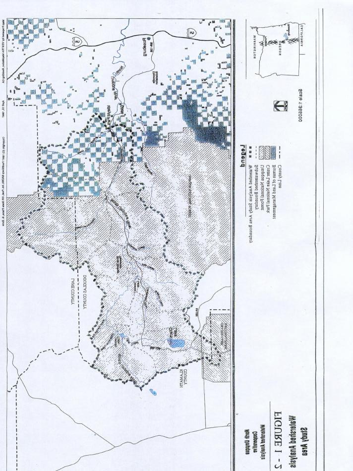
124
125 ATTACHMENT 2 BIBLIOGRAPHY OF REPORTS AND INFORMATION PRODUCED FROM THE NORTH UMPQUA COOOPERATIVE WATERSHED ANALYSIS
126 BIBLIOGRAPHY OF REPORTS AND INFORMATION PRODUCED FROM THE NORTH UMPQUA COOPERATIVE WATERSHED ANALYSIS 12 JANUARY 2001 DOCUMENTS PREPARED BY NORTH UMPQUA COOPERATIVE WATERSHED ANALYSIS SCIENCE TEAM AND DISTRIBUTED TO THE RESOURCE TEAM Synthesis Report and Appendices: Stillwater Sciences The North Umpqua cooperative watershed analysis synthesis report. Prepared by Stillwater Sciences, Berkeley, California for PacifiCorp, Portland, Oregon. Stillwater Sciences Daily average hydrographs for instream flow studies. Technical Appendix 4-1 to The North Umpqua cooperative watershed analysis synthesis report. Prepared by Stillwater Sciences, Berkeley, California for PacifiCorp, Portland, Oregon. Stillwater Sciences Methods for trout growth model. Technical Appendix 4-2 to The North Umpqua cooperative watershed analysis synthesis report. Prepared by Stillwater Sciences, Berkeley., California for PacifiCorp, Portland, Oregon. Stillwater Sciences Bed substrate mobility in the North Umpqua River, Copeland Gaging Station. Technical Appendix 7-1 to The North Umpqua cooperative watershed analysis synthesis report. Prepared by Stillwater Sciences, Berkeley, California for PacifiCorp, Portland, Oregon. Stillwater Sciences Minimum flow release alternatives for Slide Creek, Toketee, and Fish Creek bypass reaches under fish passage scenarios. Technical Appendix 7-3 to The North Umpqua cooperative watershed analysis synthesis report. Prepared by Stillwater Sciences, Berkeley, California for PacifiC;orp, Portland, Oregon. Stillwater Sciences Sediment budget for the North Umpqua River basin. Appendix 2-1 to The North Umpqua cooperative watershed analysis synthesis report. Prepared by Stillwater Sciences. Berkeley, California for PacifiCorp, Portland, Oregon. ADDITIONAL INFORMATION REQUESTS: Stillwater Sciences Determine whether a barrier to fish migration exists under Soda Springs Reservoir. Prepared by the Aquatic Subgroup of the North Umpqua Cooperative Watershed Analysis Science Team for the North Umpqua Resource Team. Berkeley, California. Stillwater Sciences Evaluation of the option of providing fish passage at Slide Creek Dam and of habitat quality in the 1.4-mile reach upstream of Slide Creek Dam. Prepared by the Aquatic Subgroup of the North Umpqua Cooperative Watershed Analysis Science Team for the North Umpqua Resource 'ream. Berkeley, California.
127 Stillwater Sciences Pros and cons of dropping the "trap-and-haul" alternative from the list of fish passage options under consideration for Soda Springs Dam. Prepared by the Aquatic Subgroup of -the North Umpqua Cooperative Watershed Analysis Science Team for the North Umpqua Resource Team. Berkeley, California. Stillwater Sciences Estimate the potential long-term effects of Soda Springs dam removal on water quality. Prepared by the Aquatic Subgroup of the North Umpqua Cooperative Watershed Analysis Science Team for the North Umpqua Resource Team. Berkeley, California. Stillwater Sciences Potential downstream effects of releasing sediment from Soda Springs reservoir if Soda Springs dam were removed. Prepared by the Geomorphology Subgroup of the North Umpqua Cooperative Watershed Analysis Science Team for the North Umpqua Resource Team. Berkeley, California. Stillwater Sciences Assessment of historical habitat conditions in the reach of the North Umpqua River currently inundated by Soda Springs reservoir. Prepared by the Aquatic Subgroup of the North Umpqua Cooperative Watershed Analysis Science Team for the North Umpqua Resource Team. Berkeley, California. Stillwater Sciences Estimate potential costs of specific off site mitigation alternatives, including conservation easements, land acquisition, and habitat enhancements, using a case study of the Canton Creek basin. Prepared by the Aquatic Subgroup of the North Umpqua Cooperative Watershed Analysis Science Team for the North Umpqua Resource Team. Berkeley, California. Stillwater Sciences Reservoir and forebay management options addressing stillwater amphibians. Prepared by the Terrestrial Subgroup of the North Umpqua Cooperative Watershed Analysis Science Team for the North Umpqua Resource Team. Berkeley, California. Stillwater Sciences Estimates of potential pre-smolt production using the reference model under various enhancement scenarios in the Canton Creek basin. Prepared by the Aquatic Subgroup of the North Umpqua Cooperative Watershed Analysis Science Team for the North Umpqua Resource Team. Berkeley, California. Stillwater Sciences Dam break analysis. Technical report prepared by the Aquatic and Geomorphology Subgroups of the North Umpqua Cooperative Watershed Analysis Science Team for the North Umpqua Resource Team. Berkeley, California. Stillwater Sciences Dam break analysis: executive summary. Prepared by the Aquatic and Geomorphology Subgroups of the North Umpqua Cooperative Watershed Analysis Science Team for the North Umpqua Resource Team. Berkeley, California. Stillwater Sciences Preliminary modeling of fine sediment release from Soda Springs Reservoir in the event of dam removal, and the associated impacts of suspended sediment on
128 adult salmonids: executive summary. Prepared by the Aquatic and Geomorphology Subgroups of the North Umpqua Cooperative Watershed Analysis Science Team for the North Umpqua Resource Team. Berkeley, California. Stillwater Sciences Preliminary mode.mg of sand/silt release from Soda Springs reservoir in the event of dam removal. Technical report prepared by the Aquatic and Geomorphology Subgroups of the North Umpqua Cooperative Watershed Analysis Science Team for the North Umpqua Resource Team. Berkeley, California. Stillwater Sciences Preliminary assessment of issues related to sediment augmentation at Soda Springs Dam. Prepared by the Geomorphology Subgroup of the North Umpqua Cooperative Watershed Analysis Science Team for the North Umpqua Resource Team. Berkeley, California. Stillwater Sciences Criteria for evaluation of management alternatives for connectivity at Soda Springs dam. Prepared by the Soda Springs Connectivity Subgroup of the North Umpqua Cooperative 'Watershed Analysis Science Team for the North Umpqua Resource Team. Berkeley, California. Stillwater Sciences Methods for achieving connectivity at Soda Springs dam under a dam-in-place scenario. Prepared by the Soda Springs Connectivity Subgroup of the North Umpqua Cooperative Watershed Analysis Science Team for the North Umpqua Resource Team. Berkeley, California. Stillwater Sciences Dam-in-place alternative: further responses to questions from. the Soda Springs Connectivity Subgroup. Prepared by the North Umpqua Cooperative Watershed Analysis Science Team for the North Umpqua Resource Team. Berkeley, California. Stillwater Sciences Summary of existing information related to connectivity at Soda Springs dam. Prepared by the North Umpqua Cooperative Watershed Analysis Science Team for the North Umpqua Resource Team. Berkeley, California. Stillwater Sciences Geomorphic effects of Soda Springs dam and potential effects on aquatic habitat. North Umpqua Cooperative Watershed Analysis additional information request. Working draft report. Prepared by Stillwater Sciences, Berkeley, California for PacifiCorp, Portland, Oregon. DOCUMENTS PREPARED BY STILLWATER SCIENCES AND DISTRIBUTED TO THE RESOURCE TEAM: Stillwater Sciences Examples of adaptive management approach to establishing instream flows for spring Chinook spawning in Slide Creek bypass reach. Prepared for the North Umpqua Resource Team. Berkeley, California. Stillwater Sciences Stillwater Sciences' proposed resource enhancement packages. Prepared for the North Umpqua Resource Team. Berkeley, California.
129 Stillwater Sciences Proposed off-site enhancement package. North Umpqua Cooperative Watershed Analysis additional information request. Working draft report. Prepared by Stillwater Sciences, Berkeley, California for PacifiCorp, Portland, Oregon. RESPONSES TO MEDIATION TEAM INFORMATION REQUESTS: Stillwater Sciences Potential predation on juvenile anadromous salmonids~ in Soda Springs Reservoir under a fish passage scenario. Response to Mediation Team information request. Prepared by Stillwater Sciences, Berkeley, California for PacifiCorp, Portland, Oregon. Stillwater Sciences Potential spawning habitat for anadromous salmonids in the upper reach of Soda Springs Reservoir. Response to Mediation Team information request. Prepared by Stillwater Sciences, Berkeley, California for PacifiCorp, Portland, Oregon. Stillwater Sciences Estimates of current sediment accumulation in Soda Springs reservoir and the location of historical channel features within the reservoir reach. Response to Mediation Team information request. Prepared by Stillwater Sciences, Berkeley, California for Pa.cifiCorp, Portland, Oregon. Stillwater Sciences Preliminary conceptual design (10% design): Created wetland and alternative conveyance of peaking flows from Lemolo No. 2 powerhouse. Response to Mediation Team request. Prepared by Stillwater Sciences, Berkeley, California for PacifiCorp, Portland, Oregon. Stillwater Sciences Percent peak weighted usable area (WUA) analysis of instream flow alternatives. Response to Mediation Team information request. Prepared by Stillwater Sciences, Berkeley, California for PacifiCorp, Portland, Oregon. Stillwater Sciences Assessment of spawning gravel in the North Umpqua River reach upstream of Slide Creek dam. Response to Mediation Team information request. Prepared by Stillwater Sciences, Berkeley, California for PacifiCorp, Portland, Oregon. Stillwater Sciences The potential effect of lowering Soda Springs reservoir on the gravel bars at the upper end of Soda Springs reservoir. Response to Mediation Team information request. Prepared by. Stillwater Sciences, Berkeley, California for PacifiCorp, Portland, Oregon. DOCUMENTS PREPARED BY OTHER CONSULTANTS DISTRIBUTED TO RESOURCE OR SCIENCE TEAMS: Raytheon Corporation Wildlife enhancement conceptual design and cost estimates. Final draft report. Prepared for PacifiCorp, Portland, Oregon. Raytheon Corporation Operational scenarios with regard to Soda Springs dam removal. Handout for M. Grubb's 19 November 1998 presentation to the North Umpqua Cooperative;
130 Watershed Analysis Resource Team meeting. Prepared by Raytheon Corporation, Portland, Oregon. Raytheon Corporation Soda Springs Dam removal technical feasibility study. Draft report dated June Prepared by Raytheon Corporation, Portland, Oregon. Raytheon Corporation Monthly calender of river flows and fish species usage. Handout for 2425 June 1999 presentation to the North Umpqua Cooperative Watershed Analysis Resource Team meeting. Prepared by Raytheon Corporation (with input from Stillwater Sciences and ODFW), Portland, Oregon. Raytheon Corporation Soda Springs Dam removal technical feasibility study: draft executive summary. Handout for June 1999 presentation to the North Umpqua Cooperative Watershed Analysis Resource Team meeting by Raytheon Corporation, Portland, Oregon. Raytheon Corporation Soda Springs Dam removal operational evaluations. Overhead transparencies for June 1999 presentation to the North Umpqua Cooperative Watershed Analysis Resource Team meeting. Prepared by Raytheon Corporation, Portland, Oregon. Raytheon Corporation Information packet for Soda Springs dam connectivity, North Umpqua Project. Prepared for the North Umpqua Cooperative Watershed Analysis Resource Team by Raytheon Corporation, Portland, Ors gon. Raytheon Corporation North Umpqua canal connectivity/geologic assessment of mitigation measures Lemolo No. 2, Clearwater No. 2, and Fish Creek, including estimates of construction costs. Revised draft. 15 September Stevenson, R. G North Umpqua canal connectivity/geologic assessment of mitigation measures Lemolo No.2, Clearwater No. 2, and Fish Creek, including estimates of construction costs: review summary. 3 November U. S. Army Corps of Engineers Review of construction cost estimates and power revenue losses for the North Umpqua Hydropower Project.
131 ATTACHMENT 3 ASSESSMENT OF SPAWNING GRAVEL IN THE NORTH UMPQUA RIVER REACH UPSTREAM OF SLIDE CREEK DAM (STILLWATER SCIENCES 2000)
132 I. Introduction Response to Mediation Team Information Request Assessment of spawning gravel in the North Umpqua River reach upstream of Slide Creek dam Draft for Science Team Review 25 September 2000 The North Umpqua River in the 1.4-mile reach between Slide Creek dam and Toketee Falls currently supports resident fish populations. Historically, Toketee Falls was the upstream barrier on the mainstem North Umpqua River to anadromous salmonids. Under current conditions, anadromous fish are blocked by Soda Springs dam, which is downstream of Slide Creek dam. Previous reports (North Umpqua Cooperative Watershed Analysis [Stillwater Sciences 1998a] and Evaluation of the option of providing fish passage at Slide Creek dam and of habitat quality in the 1.4- mile reach upstream of Slide Creek dam [Stillwater Sciences 1998b]) have indicated that good quality holding and rearing habitat for spring Chinook and steelhead occurs upstream of Slide Creek dam, but spawning habitat for anadromous salmonids is very limited. Since the distribution of these reports, habitat between Slide Creek dam and Toketee Falls (that is, within the Toketee full-flow reach and the Toketee bypass reach) has been further evaluated in the field on three occasions. This report provides information on gravel patches under current conditions. II. Methods On 26 July 2000, members of the Science Team and Mediation Team (Peter Lickwar of U.S. Fish and Wildlife Service, Ken Furguson of the Steamboaters, Frank Ligon and Dirk Pedersen of Stillwater Sciences, and Jim Lynch of Stoel Rives) walked the Toketee bypass reach up to Toketee Falls and videotaped all potential spawning habitat within the channel bed. On 25 August 2000, Forest Service scientists (Dean Grover, Jeff Dose, Mikeal Jones, and Rick Golden) walked the Toketee bypass reach up to Toketee Falls. They estimated the number and size of gravel patches. On 4 September 2000, Rich Grost of RTG Fisheries Research and Photography and Greg Fanslow of Stillwater Sciences surveyed the Toketee full-flow reach and the Toketee bypass reach up to Toketee Falls. They mapped the location, estimated the size, and evaluated the quality of gravel patches. Gravels were classified as low quality if they were highly angular or heavily embedded with sand. Gravels were classified as moderate or high quality for anadromous salmonid spawning if - substrate Dsp was estimated at 10 to 69 mm (Kondolf and Wolman 1993), patch size was at least 1 m 2, gravels appeared to be sufficiently loose (not cemented) to be worked by anadromous salmonids, and gravel depth was at least 6 inches over bedrock.
133 III. Results In the Toketee full-flow reach, the channel is primarily straight and confined by rip-rap and steep banks. on both sides. No gravels suitable for spawning were identified. In the Toketee bypass reach downstream of Toketee Falls, the channel is mostly narrow and constrained by basalt cliffs, and in the relatively wide sections (e.g. a split channel area and a wide bedrock flat), the gradient is steep and few gravels were observed. The portions of the reach that are not constrained have steep gradients and few gravel deposits. Very few gravel patches were identified on any of the field trips as suitable for anadromous salmonid spawning. Some of the gravels that were observed were rounded and of suitable size for spawning; however, the patches were small, and many of the gravels had a high component of sand. The observations of gravel patches in the bypass reach were fairly consistent among the three field trips. On the 26 July Science Team/Mediation Team field trip, about 5 gravel patches in the channel bed were observed and videotaped. One was within the wetted channel and the other four were outside of the wetted channel (the flows occurring at the time were approximately 20 cfs). The quantity of gravels was not estimated on this trip. The videotape produced from this field trip was shown at 17 August 2000 Science Team meeting and was then provided to Triangle Associates. On the 25 August Forest Service field trip, 5 patches were again observed. One was within the wetted channel (the flows occurring at the time were approximately 20 cfs) and four were described as on the bank above the waterline; we assumed that these were on the channel bed. but out of the water, and were the same as those identified on 26 July. The total area of the gravel patches was estimated at about 10 m2. A rough estimate of the flow necessary to cover the patches above the waterline was about cfs. On the 4 September Stillwater Sciences field trip, the team attempted to map all gravels irrespective of their quality and location in the channel, in order to be comprehensive. They therefore included patches of marginal quality, and identified more patches than the groups did on 26 July or 25 August. Eight gravel patches were mapped that were roughly estimated to be covered at about cfs (Table I ). The patches were about 2 to 3 m2 in area each, totaling about 21 m2. None of the patches was categorized as high quality, one was categorized as moderate quality, and the other seven were categorized as low quality. There are several uncertainties regarding how different management options affecting flows, sediment dynamics, and large woody debris dynamics would influence spawning habitat quality and quantity in the Toketee bypass reach. The re-connection of the Clearwater River to the Toketee bypass reach would increase sediment supply to the reach, although an evaluation of how this might affect spawning gravel quality has not been conducted. The Science Team has discussed the possibility of evaluating the effects of increased gravel supply by comparing gravel deposition in the Slide Creek bypass reach of the North Umpqua River upstream of the Fish Creek confluence (where gravel supply is similar to that in the Toketee bypass reach) with gravel deposition downstream of the Fish Creek confluence (where gravel supply is greatly augmented). An increase in supply of large woody debris over the Toketee dam could increase the roughness of the channel, but the highly confined channel and the high stream power limit the likelihood of debris being deposited in the channel in a way that contributes to gravel deposition. Overall, it appears that the Toketee reach has favorable anadromous salmonid holding and rearing habitat, but spawning habitat is very limited.
134 IV. References Kondolf, G. M., and M. G. Wolman The sizes of salmonid spawning gravels. Water Resources Research 29: Stillwater Sciences. 1998a. The North Umpqua cooperative watershed analysis synthesis report. Prepared by Stillwater Sciences, Berkeley, California for PacifiCorp, Portland, Oregon. Stillwater Sciences. 1998b. Evaluation of the option of providing fish passage at Slide Creek Dam and of habitat quality in the 1.4-mile reach upstream of Slide Creek Dam. Prepared by the Aquatic Subgroup of the North Umpqua Cooperative Watershed Analysis Science Team for the North Umpqua Resource Team. Berkeley, California.
135 Table 1. Potential spawning patches in the Toketee bypass reach downstream of Toketee Falls (based on 4 September 2000 field survey) Approximate Patch Location (ft upstream of Toketee powerhouse) Approximate Patch Size (m 2 ) Patch Quality (low, moderate, high) Species that Could Potentially Use Patch for Spawning m 2 Low coho, cutthroat m 2 Moderate steelhead, Chinook m 2 Low coho, steeihead, cutthroat, Chinook m 2 Low coho, steelhead, cutthroat, Chinook m 2 Low coho, steelhead, cutthroat, Chinook m 2 Low coho, steelhead, Chinook 1,850 2 m 2 Low coho, steelhead, Chinook 1,850 2 m 2 Low coho, steelhead, Chinook Total 21 m 2
136 ATTACHMENT 4 NORTH UMPQUA DIVERSION DEVELOPMENT
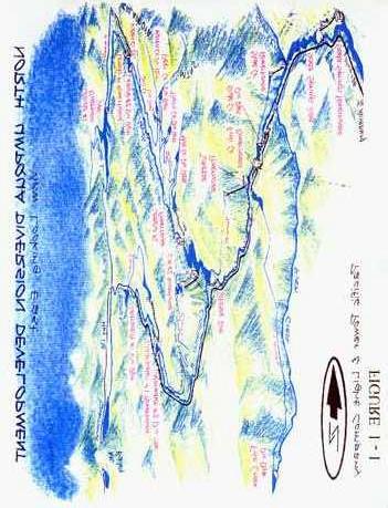
137
138 ATTACHMENT 5 LOCATION MAP
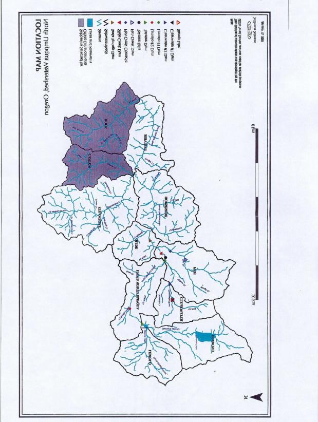
139
140 ATTACHMENT 6 ENHANCEMENT AREA MAP
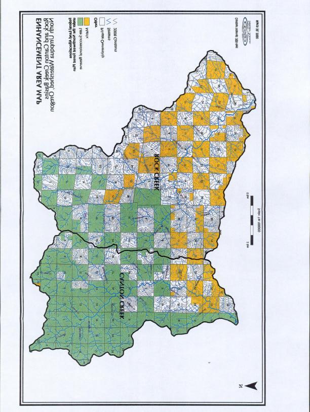
141
142 ATTACHMENT 7 LOCATIONS OF PROPOSED MITIGATION MEASURES
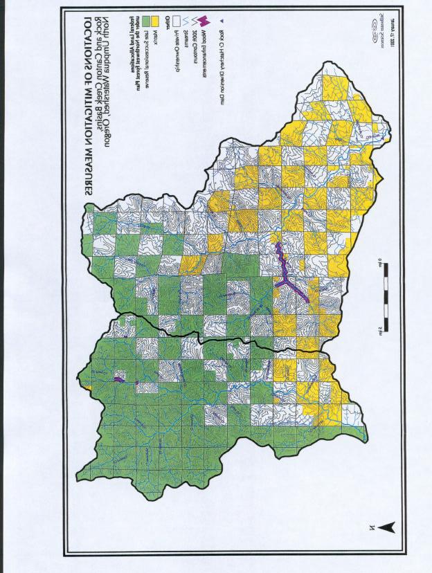
143
144 ATTACHMENT 8 POTENTIAL IMPROVED ACCESS FOR ANADROMOUS SALMONIDS
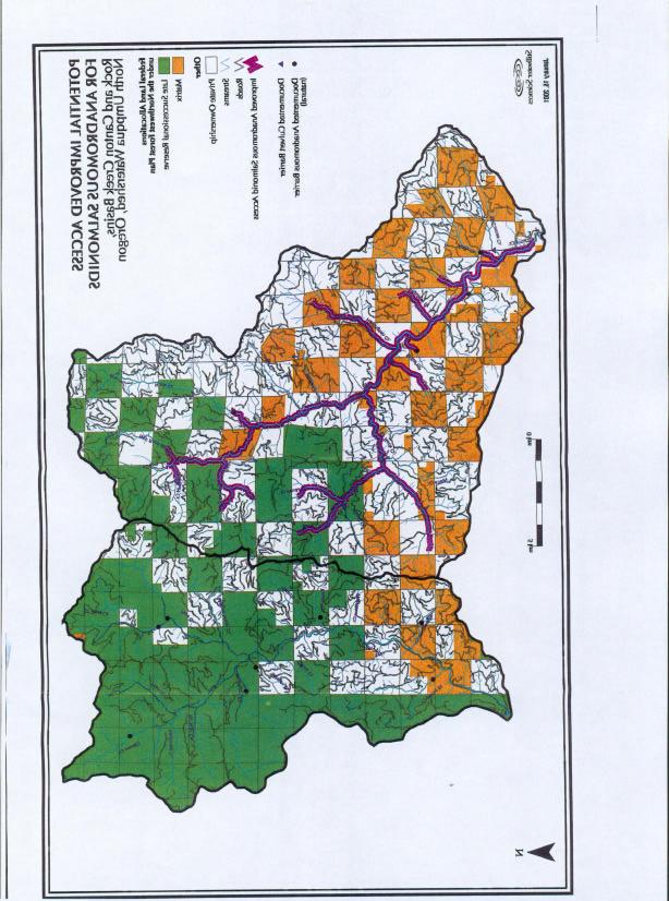
145
146 ATTACHMENT 9 EXAMPLE STUDY FOR MONITORING ROCK CREEK LARGE WOODY DEBRIS ENHANCEMENTS
147 ATTACHMENT 9: EXAMPLE STUDY DESIGN FOR MONITORING ROCK CREEK LARGE WOODY DEBRIS ENHANCEMENTS The objective of large woody debris enhancements in East Fork Rock Creek is to increase instream habitat complexity, and thereby increase the winter carrying capacity for coho salmon. Therefore, a direct biological performans evaluation will be used to determine the pre- and post-enhancement winter carrying capacity of the habitat. PacifiCorp will implement a BACI (before-after-control-impact) experimental design, in which for 3 years prior to enhancements, a 0.5-mile control reach and two 0.5-mile treatment reaches in East Fork Rock Creek will be experimentally seeded with coho salmon eggs. Seeding will be achieved with artifical egg boxes (e.g., Whitlock-Vibert Boxes) containing known numbers of wild coho eggs. Experimental seeding of the habitat will ensure that the habitat at the onset of winter is fully saturated. This will eliminate the effect of variable adult returns on numbers of fish overwintering. Methods to determine the winter carrying capacity may include population estimates conducted in the control and all treatment reaches in the early fall of each year, and again following each fall and winter freshet to determine the winter carrying capacity. After three years of pre-enhancement monitoring, the treatment reaches will be enhanced. To determine the relationship between large woody debris density and carrying capacity of the habitat, the density of logs used in each treatment reach will be varied. Under scenario I (logs donated to mitigation effort) 3 reaches will be experimentally treated with densities of 80 logs/mile, 160 logs/mile, and 240 logs/mile. Under scenario II (all logs need to be purchased) 2 reaches approximately 0.5 miles long will be experimentally treated with densities of approximately 80 logs/mile and 160 logs/mile. The postenhancement monitoring portion of the BACI design will be initiated after the treatment reach has received a minimum of a bankfull flow (1.5-yr recurrence interval flood), to allow the large woody debris to become functional.
148 Appendix F To the Settlement Agreement Effective June 13, 2001 Authorized Representatives of the Parties PacifiCorp Terry Flores Director, Hydro Re-licensing PacifiCorp 825 NE Multnomah Portland, OR Phone: (503) Fax: (503) With Additional Copies To: Randy Landolt Jerry Fish Managing Director, Hydro Resources Attorney PacifiCorp Stoel Rives LLP 825 NE Multnomah 900 SW Fifth Ave., Suite 2600 Portland, OR Portland, OR Phone: (503) Phone: (503) Facsimile: (503) Facsimile: (503) USDA Forest Service Don Ostby Forest Supervisor, Umpqua National Forest USDA Forest Service, Region 6 Box 1008 Roseburg, OR Phone: (541) Facsimile: (541) With Additional Copies To: Walter A. Dortch Jocelyn B. Somers Regional Hydropower Coordinator Attorney, USDA Office of the General Counsel USDA Forest Service, Region Federal Building 1405 Emmens Street 1220 SW 3rd Ave. Darrington, WA Portland, OR Phone: (360) ext. 245 Phone: (503) Facsimile: (360) Facsimile: (503)
149 USDI Fish and Wildlife Service With Additional Copy To: Kemper McMaster Craig Tuss State Supervisor Roseburg Office Supervisor Oregon State Office Roseburg Field Office U.S. Fish and Wildlife Service U.S. Fish and Wildlife Service 2600 SE 98th Avenue, Suite NW Stewart Parkway Portland, OR Roseburg, OR Phone: (503) Phone: (541) Facsimile: (503) Facsimile: (541) USDI Bureau of Land Management With Additional Copy To: Cary Osterhaus Jay Carlson Roseburg District Manager Swiftwater Field Manager Bureau of Land Management Bureau of Land Management 777 NW Garden Valley Blvd 777 NW Garden Valley Blvd. Roseburg, OR Roseburg, OR Phone: (541) Phone: (541) Facsimile: (541) Facsimile: (541) National Marine Fisheries Service Brian Brown Assistant Regional Administrator Hydropower Program Northwest Region National Marine Fisheries Service 525 NE Oregon Street, Suite 500 Portland, OR Phone: (503) Facsimile: (503)
150 With Additional Copies To: Keith Kirkendall Oregon Hydropower Coordinator Northwest Region National Marine Fisheries Service Brett Joseph Attorney Advisor Office of General Counsel Northwest National Oceanic and Atmospheric Admin. 525 NE Oregon Street, Suite Sand Point Way, NE Portland, OR Seattle, WA Phone: (503) Phone: (206) Facsimile: (503) Facsimile: (206) Oregon Department of Environmental Quality John W. Blanchard Manager, Basin Planning and Management Oregon Department of Environmental Quality 201 W. Main Suite 2-D Medford, OR Phone: (541) ext. 240 Facsimile: (541) Oregon Department of Fish and Wildlife Robert Mullen Director, Southwest Region Oregon Department of Fish and Wildlife 4192 North Umpqua Highway Roseburg, OR Phone: (541) Facsimile: (541) Oregon Water Resources Department Richard D. Bailey Administrator, Water Rights, Adjudications and Hydro Power Oregon Water Resources Department th Street NE Salem, OR Phone: (503) ext. 256 Facsimile: (503)
151 Appendix G To the Settlement Agreement Effective June 13, 2001 Agreement for Management of Birds on Powerlines
152
153
107 FERC 61,282 UNITED STATES OF AMERICA FEDERAL ENERGY REGULATORY COMMISSION
 107 FERC 61,282 UNITED STATES OF AMERICA FEDERAL ENERGY REGULATORY COMMISSION Before Commissioners: Pat Wood, III, Chairman; Nora Mead Brownell, and Joseph T. Kelliher. Public Utility District No. 1 of
A. PURPOSE B. BACKGROUND
 MEMORANDUM OF UNDERSTANDING BETWEEN THE U.S. DEPARTMENT OF DEFENSE AND THE U.S. FISH AND WILDLIFE SERVICE AND THE ASSOCIATION OF FISH AND WILDLIFE AGENCIES FORA COOPERATIVE INTEGRATED NATURAL RESOURCE
145 FERC 62,070 UNITED STATES OF AMERICA FEDERAL ENERGY REGULATORY COMMISSION
 145 FERC 62,070 UNITED STATES OF AMERICA FEDERAL ENERGY REGULATORY COMMISSION Public Utility District No. 1 of Douglas County, Washington Project No. 2149-163 ORDER APPROVING BULL TROUT STRANDING, ENTRAPMENT,
COMMENTS Draft Environmental Impact Statement McCloud Pit Hydroelectric Project (FERC No. 2106) P Applicant: Pacific Gas & Electric Company
 P Applicant: Pacific Gas & Electric Company") COMMENTS Draft Environmental Impact Statement McCloud Pit Hydroelectric Project (FERC No. 2106) P-2106-059 Applicant: Pacific Gas & Electric Company Filed by: FERC Projects Director California Sportfishing
COMMENTS Draft Environmental Impact Statement McCloud Pit Hydroelectric Project (FERC No. 2106) P-2106-059 Applicant: Pacific Gas & Electric Company Filed by: FERC Projects Director California Sportfishing
Endangered Species Act and FERC Hydroelectric Projects. Jeff Murphy & Julie Crocker NHA New England Meeting November 16, 2010
 Endangered Species Act and FERC Hydroelectric Projects Jeff Murphy & Julie Crocker NHA New England Meeting November 16, 2010 Shortnose Sturgeon Federally listed as endangered in 1967 Listed under the sole
Amendment to a Biological Assessment/Evaluation completed for the Coon Creek Land Disposal completed December Grand Valley Ranger District
 Amendment to a Biological Assessment/Evaluation completed for the Coon Creek Land Disposal completed December 2007 Grand Valley Ranger District Grand Mesa, Uncompahgre, Gunnison National Forests Prepared
Past, Present and Future Activities Being Conducted in the Klamath River Basin Related to the Protection and Recovery of Fish and Their Habitat
 Past, Present and Future Activities Being Conducted in the Klamath River Basin Related to the Protection and Recovery of Fish and Their Habitat National Marine Fisheries Service March 2003 The Department
Final Bull Trout Genetics Monitoring Plan for the Wallowa Falls Hydroelectric Project. (FERC No. P-308) June 2017
 June 2017") Final for the Wallowa Falls Hydroelectric Project (FERC No. P-308) June 2017 Prepared by: Jeremiah Doyle PacifiCorp 825 NE Multnomah Street Portland, OR 97232 June, 2017 Page 1 of 8 Table of Contents 1.0
Final for the Wallowa Falls Hydroelectric Project (FERC No. P-308) June 2017 Prepared by: Jeremiah Doyle PacifiCorp 825 NE Multnomah Street Portland, OR 97232 June, 2017 Page 1 of 8 Table of Contents 1.0
THREATENED, ENDANGERED, AND SENSITIVE SPECIES 2010 ANNUAL REPORT
 LICENSE ARTICLE 410 THREATENED, ENDANGERED, AND SENSITIVE SPECIES 2010 ANNUAL REPORT REPORTING PERIOD JANUARY 1 DECEMBER 31, 2010 BAKER RIVER HYDROELECTRIC PROJECT FERC No. 2150 Puget Sound Energy Bellevue,
Project Award Presentation
 University of Massachusetts Amherst ScholarWorks@UMass Amherst International Conference on Engineering and Ecohydrology for Fish Passage International Conference on Engineering and Ecohydrology for Fish
AGREEMENT BETWEEN THE U.S. FISH AND WILDLIFE SERVICE AND THE U.S. ARMY CORPS OF ENGINEERS FOR CONDUCTING FISH AND WILDLIFE COORDINATION ACT ACTIVITIES
 AGREEMENT BETWEEN THE U.S. FISH AND WILDLIFE SERVICE AND THE U.S. ARMY CORPS OF ENGINEERS FOR CONDUCTING FISH AND WILDLIFE COORDINATION ACT ACTIVITIES ARTICLE I- INTRODUCTION a. Section 1 of the Fish and
CONNECTICUT RIVER WATERSHED COUNCIL The River Connects Us
 CONNECTICUT RIVER WATERSHED COUNCIL The River Connects Us Upper Valley: P.O. Box 206, Saxtons River, VT 05154 Electronic Filing UNITED STATES OF AMERICA FEDERAL ENERGY REGULATORY COMMISSION Grafton Hydro,
Subject: Wells Hydroelectric Project FERC Project No Bull Trout Management Plan and Incidental Take Annual Report
 Ms. Jessica Gonzales April 15, 2015 Wenatchee Office Lead Central Washington Field Office U. S. Fish and Wildlife Service 215 Melody Lane, Suite 119 Wenatchee, WA 98801-5933 Subject: Wells Hydroelectric
CMM Conservation and Management Measure for the Management of New and Exploratory Fisheries in the SPRFMO Convention Area.
 CMM 13-2016 1 Conservation and Management Measure for the Management of New and Exploratory Fisheries in the SPRFMO Convention Area. The Commission of the South Pacific Regional Fisheries Management Organisation;
Pre-Application Document Kaweah Project (FERC Project No. 298)
") TABLE OF CONTENTS Page 3.12 Aesthetic Resources... 3.12-1 3.12.1 Information Sources... 3.12-1 3.12.2 Setting... 3.12-1 3.12.3 Project Facilities... 3.12-2 3.12.4 Previous Visual Resources Assessment...
TABLE OF CONTENTS Page 3.12 Aesthetic Resources... 3.12-1 3.12.1 Information Sources... 3.12-1 3.12.2 Setting... 3.12-1 3.12.3 Project Facilities... 3.12-2 3.12.4 Previous Visual Resources Assessment...
Project 184 Preferred Canal Drainage Structure and Release Point Plan
 Project 184 Preferred Canal Drainage Structure and Release Point Plan September 2011 Version 5.0 REVISION HISTORY Page Description Date 7 Added Section 5.1 Plan Modifications 09/08/11 9 Modified Table
Trout Unlimited Comments on the Scope of Environmental Impact Statement for the Constitution Pipeline Project, Docket No. PF12-9
 October 9, 2012 Kimberly D. Bose, Secretary Federal Energy Regulatory Commission 888 First Street, NE, Room 1A Washington, DC 20426 RE: Trout Unlimited Comments on the Scope of Environmental Impact Statement
Santa Clara Valley Habitat Conservation Plan/ Natural Community Conservation Plan
 Santa Clara Valley Habitat Conservation Plan/ Natural Community Conservation Plan Overview Workshop January 21, 2006 David Zippin, Ph.D. Project Manager Paola Bernazzani, M.S. Deputy Project Manager Section
Restoring the Kootenai: A Tribal Approach to Restoration of a Large River in Idaho
 Restoring the Kootenai: A Tribal Approach to Restoration of a Large River in Idaho Susan Ireland, Kootenai Tribe of Idaho Future of our Salmon Conference Technical Session August 2016 Healthy Floodplains,
FINAL Caples Lake Fisheries Management Plan. Version 4.0
 FINAL Caples Lake Fisheries Management Plan Version 4.0 August 15, 2008 Purpose The Caples Lake Fisheries Management Plan (Plan) outlines the stocking plan to reestablish a sport fishery in Caples Lake
AOGA EDUCATIONAL SEMINAR. Endangered Species Act
 AOGA EDUCATIONAL SEMINAR Endangered Species Act ESA AUTHORITY & PROCESS The ESA authorizes the Secretaries of Interior and Commerce to conserve fish, wildlife and plants facing extinction by: (1) listing
Fish Passage from the Tidewater to the Sierras Workshop - Fish Passage at High Dams - Part 1
 + Fish Passage from the Tidewater to the Sierras Workshop - Fish Passage at High Dams - Part 1 35 th Annual Salmonid Restoration Conference held in Davis, CA from March 29 April 1, 2017. Fish Passage from
Final Fish Salvage & Temporary Tailrace Barrier Report for the Wallowa Falls Hydroelectric Project Tailrace. (FERC No. P-308) December 18, 2017
 December 18, 2017") Final for the Wallowa Falls Hydroelectric Project Tailrace (FERC No. P-308) December 18, 2017 Prepared by: Jeremiah Doyle PacifiCorp 825 NE Multnomah Street Portland, OR 97232 December 18, 2017 Page 1
Final for the Wallowa Falls Hydroelectric Project Tailrace (FERC No. P-308) December 18, 2017 Prepared by: Jeremiah Doyle PacifiCorp 825 NE Multnomah Street Portland, OR 97232 December 18, 2017 Page 1
Appendix C - Guidance for Integrating EFH Consultations with Endangered Species Act Section 7 Consultations
 Appendix C - Guidance for Integrating EFH Consultations with Endangered Species Act Section 7 Consultations C.1 Guidance for Integrating Magnuson-Stevens Fishery Conservation and Management Act EFH Consultations
CMM on Management of New and Exploratory Fisheries in the SPRFMO Convention Area
 7 th Annual Meeting of the Commission 23-27 January, The Hague, The Netherlands COMM7-Prop11 Amend CMM 13-2016 on Management of New and Exploratory Fisheries in the SPRFMO Convention Area Submitted by:
General Regulations for Areas Administered by the National Park Service and the Fish and Wildlife Service
 4312-52-M DEPARTMENT OF THE INTERIOR National Park Service 36 CFR Part 2 Fish and Wildlife Service 50 CFR Part 27 RIN 1024-AD70 General Regulations for Areas Administered by the National Park Service and
MEMORANDUM OF UNDERSTANDING ON THE CONSERVATION OF MIGRATORY BIRDS OF PREY IN AFRICA AND EURASIA
 MEMORANDUM OF UNDERSTANDING ON THE CONSERVATION OF MIGRATORY BIRDS OF PREY IN AFRICA AND EURASIA The Signatories Recalling that the Convention on the Conservation of Migratory Species of Wild Animals,
Agenda Item 7.1 For Information. Council CNL(10)24. Annual Report on Actions Taken Under Implementation Plans USA
24. Annual Report on Actions Taken Under Implementation Plans USA") Agenda Item 7.1 For Information Council CNL(10)24 Annual Report on Actions Taken Under Implementation Plans USA Annual Report on actions taken under the US Implementation Plan for the Calendar Year 2009
Agenda Item 7.1 For Information Council CNL(10)24 Annual Report on Actions Taken Under Implementation Plans USA Annual Report on actions taken under the US Implementation Plan for the Calendar Year 2009
ESCA. Endangered Species Conservation Act of 1969 Changed in 1973 to ESA Amended several times
 ESCA Endangered Species Conservation Act of 1969 Changed in 1973 to ESA Amended several times International Efforts http://www.cites.org/ Convention on International Trade in Endangered Species of Wild
STATE OF TENNESSEE DEPARTMENT OF ENVIRONMENT AND CONSERVATION ) ) ) ) ) ) ) ) DIRECTOR S ORDER PARTIES I.
 ) ) ) ) ) ) ) DIRECTOR S ORDER PARTIES I.") STATE OF TENNESSEE DEPARTMENT OF ENVIRONMENT AND CONSERVATION IN THE MATTER OF: TENNESSEE VALLEY AUTHORITY RESPONDENT DIVISION OF WATER POLLUTION CONTROL CASE NUMBER WPC09-0008 DIRECTOR S ORDER NOW COMES
STATE OF TENNESSEE DEPARTMENT OF ENVIRONMENT AND CONSERVATION IN THE MATTER OF: TENNESSEE VALLEY AUTHORITY RESPONDENT DIVISION OF WATER POLLUTION CONTROL CASE NUMBER WPC09-0008 DIRECTOR S ORDER NOW COMES
Columbia Lake Dam Removal Project
 Columbia Lake Dam Removal Project The Columbia Lake dam located 1/4 mile upstream of the Paulins Kill River's confluence with the Delaware River in Knowlton Township, Warren County has been proposed for
Western native Trout Status report
 Bull trout (Salvelinus confluentus) Data: Draft Recovery Plan, USFWS, 2002; FR Final Critical Habitat Rule - 2005 Partners: ID, MT, OR, WA, NV, FWS, FS, BLM, NPS, Tribes, AK, Canada Species Status review:
Controlled Take (Special Status Game Mammal Chapter)
") Controlled Take (Special Status Game Mammal Chapter) Background of issue: The current Plan contains standards including the use of controlled take as a management response tool to assist in some situations
Controlled Take (Special Status Game Mammal Chapter) Background of issue: The current Plan contains standards including the use of controlled take as a management response tool to assist in some situations
Executive Summary. Map 1. The Santa Clara River watershed with topography.
 Santa Clara River Steelhead Trout: Assessment and Recovery Opportunities December 2005 Prepared By: Matt Stoecker and Elise Kelley, Ph.D. University of California, Santa Barbara Prepared For: The Santa
Hunting, Fishing, Recreational Shooting, and Wildlife Conservation Opportunities and Coordination with States, Tribes, and Territories
 THE SECRETARY OF THE INTERIOR WASHINGTON ORDER NO. 3356 Subject: Hunting, Fishing, Recreational Shooting, and Wildlife Conservation Opportunities and Coordination with States, Tribes, and Territories Sec.
Final Bull Trout Redd Monitoring Report for the Wallowa Falls Hydroelectric Project
 Final for the Wallowa Falls Hydroelectric Project East Fork Wallowa River barrier to upstream fish migration, photo courtesy of Kendrick Moholt (FERC No. P-308) December 18, 2017 Prepared by: Jeremiah
Natural Resource Statutes and Policies
 13 Sept 2005, 1430h Kevin: Thanks, we enjoyed talking to your class today. Paul pointed out an error that I made : The Tohono O'odham Nation is the second largest reservation in the lower 48, behind the
U.N. Gen. Ass. Doc. A/CONF.164/37 (8 September 1995) <http://daccessdds.un.org/doc/undoc/gen/n95/274/67/pdf/n pdf?openelement>.
 <http://daccessdds.un.org/doc/undoc/gen/n95/274/67/pdf/n pdf?openelement>.") Agreement for the Implementation of the Provisions of the United Nations Convention on the Law of the Sea Of 10 December 1982 Relating to the Conservation and Management of Straddling Fish Stocks and Highly
Agreement for the Implementation of the Provisions of the United Nations Convention on the Law of the Sea Of 10 December 1982 Relating to the Conservation and Management of Straddling Fish Stocks and Highly
Official Journal of the European Union L 248/17
 22.9.2007 Official Journal of the European Union L 248/17 COUNCIL REGULATION (EC) No 1100/2007 of 18 September 2007 establishing measures for the recovery of the stock of European eel THE COUNCIL OF THE
COLUMBIA LAKE DAM REMOVAL PROJECT
 COLUMBIA LAKE DAM REMOVAL PROJECT Major Goals of the Columbia Lake Dam Removal: Reconnect 10 miles of the Paulins Kill River to the Delaware River, restoring natural flow regime and sediment transport.
COOPERATIVE AGREEMENT RECITALS
 COOPERATIVE AGREEMENT This Cooperative Agreement ( Agreement ) is effective as of, 2011 by and between the County of Santa Barbara (the County ) and the Santa Ynez Band of Chumash Indians (the Tribe or
APPENDIX Region 6 Inland Area Contingency Plan Compliance with Section 7 of the Endangered Species Act
 APPENDIX 56 -- Region 6 Inland Area Contingency Plan Compliance with Section 7 of the Endangered Species Act Pursuant to the Inter-agency Memorandum of Agreement Regarding Oil Spill Planning and Response
Southwest Power Pool REGIONAL STATE COMMITTEE BYLAWS
 Southwest Power Pool REGIONAL STATE COMMITTEE BYLAWS Approved: October 30, 2017 ARTICLE I 1. NAME: The organization shall be known as the Southwest Power Pool Regional State Committee ( SPP RSC ). The
PRE-FILED DIRECT TESTIMONY AND EXHIBITS OF F. ALLEN WILEY PART II
 STATE OF MAINE DEPARTMENT OF ENVIRONMENTAL PROTECTION IN RE PETITIONS FOR REVOCATION, MODIFICATION OR SUSPENSION OF PERMITS AND WATER QUALITY CERTIFICATIONS FOR THE LOCKWOOD, HYDRO- KENNEBEC, SHAWMUT AND
EXHIBIT ARWA-700 TESTIMONY OF PAUL BRATOVICH
 EXHIBIT ARWA-700 TESTIMONY OF PAUL BRATOVICH 1. I am a fisheries biologist employed by the firm of HDR, Inc. I hold a Bachelor of Science degree in Fisheries from the University of Washington, located
Columbia Lake Dam Removal Project
 Columbia Lake Dam Removal Project Major Goals of the Columbia Lake Dam Removal: Reconnect 10 miles of the Paulins Kill River to the Delaware River, restoring natural flow regime and sediment transport.
endangered species act A Reference Guide August 2013 United States marine corps
 endangered species act A Reference Guide August 2013 United States marine corps THE endangered species act PURPOSE This Reference Guide on the Endangered Species Act identifies the requirements for the
Kootenai River Habitat Restoration Program. Kootenai Tribe of Idaho - January 27, 2014 Presentation for Kootenai Valley Resource Initiative
 Kootenai River Habitat Restoration Program Kootenai Tribe of Idaho - January 27, 2014 Presentation for Kootenai Valley Resource Initiative Decline of native species Kootenai River White Sturgeon ENDANGERED
FINAL Fish Salvage Plan for the Wallowa Falls Hydroelectric Project Tailrace. (FERC No. P-308) April 19, 2017
 April 19, 2017") FINAL for the Wallowa Falls Hydroelectric Project Tailrace (FERC No. P-308) April 19, 2017 Prepared by: Jeremiah Doyle PacifiCorp 825 NE Multnomah Street Portland, OR 97232 April 19, 2017 Page 1 of 10
FINAL for the Wallowa Falls Hydroelectric Project Tailrace (FERC No. P-308) April 19, 2017 Prepared by: Jeremiah Doyle PacifiCorp 825 NE Multnomah Street Portland, OR 97232 April 19, 2017 Page 1 of 10
Attachment 6. Public Correspondence. Public correspondence received as of July 2, 2008
 Attachment 6 Public Correspondence Public correspondence received as of July 2, 2008 May 8, 2008 Roger Smith Oregon Department of Fish and Wildlife 3406 Cherry Avenue N.E. Salem, OR 97303 Mr. Smith and
Chagrin River TMDL Appendices. Appendix F
 Appendix F The following are excerpts from the Eastern Brook Trout Joint Venture s Conservation Strategy (Working Draft v.6), Conserving the Eastern Brook Trout: Strategies for Action Found at: http://www.easternbrooktrout.org/constrategy.html
Natural Resource Statutes and Policies. Who Owns the Wildlife? Treaties. Federal Laws. State Laws. Policies. Administrative Laws.
 13 Sept 2005, 1430h Kevin: Thanks, we enjoyed talking to your class today. Paul pointed out an error that I made : The Tohono O'odham Nation is the second largest reservation in the lower 48, behind the
For mutual consideration received, which is hereby acknowledged, the parties agree as follows:
 [Date] [Golf Club Name] [Handicap Chair] [Club Address] [City, State Zip] Dear Handicap Chair: Pursuant to this letter agreement (this Agreement ) between the United States Golf Association ( USGA ) and
Eastern Brook Trout. Roadmap to
 Eastern Brook Trout Roadmap to CONSERVATION Our Brook Trout heritage he wild Brook Trout is an American symbol of persistence, adaptability, and the pristine wilderness that covered North America prior
2016 Annual Work Plan
 Rocky Reach Hydroelectric Project FERC No. 2145 2016 Annual Work Plan 2015 Progress Report d per Rocky Reach Settlement Agreement, Sections 15.1.1 & 15.6.5 Reports provided by Chelan PUD Leads: Ray Heit
COUNCIL DIRECTIVE 79/409/EC. of 2 April on the conservation of the wild birds
 EN COUNCIL DIRECTIVE 79/409/EC of 2 April 1979 on the conservation of the wild birds THE COUNCIL OF THE EUROPEAN COMMUNITIES, Having regard to the Treaty establishing the European Economic Community, and
Memorandum of Understanding concerning. Conservation, Restoration and Sustainable Use of the Saiga Antelope (Saiga tatarica tatarica)
") Memorandum of Understanding concerning Conservation, Restoration and Sustainable Use of the Saiga Antelope (Saiga tatarica tatarica) Memorandum of Understanding concerning Conservation, Restoration and
Memorandum of Understanding concerning Conservation, Restoration and Sustainable Use of the Saiga Antelope (Saiga tatarica tatarica) Memorandum of Understanding concerning Conservation, Restoration and
Funding Habitat Restoration Projects for Salmon Recovery in the Snake River Region SRFB Grant Round Version: 2/19/16
 2016 SRFB Grant Round Version: 2/19/16 Funding Habitat Restoration Projects for Salmon Recovery in the Snake River Region The Project Funding Process Presented by the Snake River Salmon Recovery Lead Entity
Oregon Department of Fish and Wildlife: Inland Fisheries - Hatchery Management
 Oregon Department of Fish and Wildlife: Inland Fisheries - Hatchery Management Primary Outcome Area: Economy & Jobs Secondary Outcome Area: Healthy Environments Program Contact: Ed Bowles, 503-947-6206
STATE OF NEVADA BOARD OF WILDLIFE COMMISSIONERS
 STATE OF NEVADA BOARD OF WILDLIFE COMMISSIONERS Number: P-33 Title: Fisheries Management Program Commission Policy Number 33 References: NRS 501.105, 501.181 Effective Date: July 24, 1999 Reviewed Date:
USA RUGBY EVENT SANCTION AGREEMENT
 USA RUGBY EVENT SANCTION AGREEMENT This agreement, entered into and between USA Rugby and (name of Local Organizing Group/club shall be a part of the Sanction Agreement for the Event known as (name of
Big Cypress National Preserve. Hunting Management Plan /
 Hunting Management Plan / Public Scoping Meetings Collier County August 30, 2011 Broward County August 31, 2011 Milestone Proposed Project Timeline Date Public Scoping Comment Period August 8 September
D.B. Wilson Station CCR Landfill
 D.B. Wilson Station CCR Landfill Disposal of Coal Combustion Residuals (CCR) from Electric Utilities Final Rule Closure and Post-closure Care Plan October 11, 2016 Prepared By: Project ID: 160030A Big
P U B L I C U T I L I T Y D I S T R I C T N O.
 P U B L I C U T I L I T Y D I S T R I C T N O. 1 o f C H E L A N C O U N T Y P.O. Box 1231, Wenatchee, WA 98807-1231 327 N. Wenatchee Ave., Wenatchee, WA 98801 (509) 663-8121 Toll free 1-888-663-8121 www.chelanpud.org
Butte Environmental Council v. United States Army Corps of Engineers
 Public Land and Resources Law Review Volume 0 Case Summaries 2010-2011 Butte Environmental Council v. United States Army Corps of Engineers Jesse Froehling Follow this and additional works at: https://scholarship.law.umt.edu/plrlr
1.Mill Creek Watershed Summary Description and Land Use
 1.Mill Creek Watershed Summary Description and Land Use Table xxx: Mill Creek Watershed Overview Watershed Size 31,435 acres/49.1 sq miles/ 127.1 sq km Elevation Range 5,594 feet [4,967-10,561] Stream
Deschutes Basin Habitat Conservation Plan. Working Group Meeting December 14, 2017 Redmond, Oregon
 Deschutes Basin Habitat Conservation Plan Working Group Meeting December 14, 2017 Redmond, Oregon AGENDA Welcome and Introductions News and Updates Proposed Conservation Measures Alternative Conservation
APPENDIX 2.1 Lake Sturgeon - Mitigation and Enhancement
 APPENDIX 2.1 Lake Sturgeon - Mitigation and This page is intentionally left blank. Lake Sturgeon Mitigation and As a provincial crown corporation providing electric energy and natural gas service, Manitoba
Case 2:13-cv LKK-CKD Document 1 Filed 11/26/13 Page 1 of 14
 Case :-cv-0-lkk-ckd Document Filed // Page of 0 Kurt A. Kappes - SBN Anthony J. Cortez - SBN GREENBERG TRAURIG, LLP 0 K Street, Suite 00 Sacramento, CA - Telephone: () - Facsimile: () -0 kappesk@gtlaw.com
Steve Hemstrom Sr. Fisheries Biologist Chelan PUD Natural Resources Desk: Cell:
 From: To: Cc: Subject: Date: Attachments: Hemstrom, Steven "Lewis, Stephen" Sokolowski, Rosana 2014 Rocky Reach Bull Trout Report Wednesday, June 18, 2014 3:01:07 PM Final 2014 Rocky Reach Bull Trout Observations
APPROVE A RESOLUTION ADOPTING A COMPLETE STREETS POLICY
 STAFF REPORT MEETING DATE: September 13, 2016 TO: FROM: City Council Bob Brown, Community Development Director Russ Thompson, Public Works Director Patrick Filipelli, Management Analyst 922 Machin Avenue
3. The qualification raised by the ISRP is addressed in #2 above and in the work area submittal and review by the ISRP as addressed in #1.
 Please find attached a response from The Confederated Tribes of the Warm Springs Reservation of Oregon (CTWSRO) for Project # 2008-301-00, Habitat Restoration Planning, Design and Implementation within
Rhode Island Department of Environmental Management Division of Fish and Wildlife American Shad Habitat Plan for the Pawcatuck River
 Rhode Island Department of Environmental Management Division of Fish and Wildlife American Shad Habitat Plan for the Pawcatuck River Prepared by: Phil Edwards, Rhode Island Department of Environmental
Press Release New Bilateral Agreement May 22, 2008
 Informational Report 3 June 2008 Press Release New Bilateral Agreement May 22, 2008 The Pacific Salmon Commission is pleased to announce that it has recommended a new bilateral agreement for the conservation
Olympic Agenda Recommendation 28. Support autonomy
 Olympic Agenda 2020 Recommendation 28 Support autonomy The IOC to create a template to facilitate cooperation between national authorities and sports organisations in a country. In application of Recommendation
Final Fish Salvage & Temporary Tailrace Barrier Report for the Wallowa Falls Hydroelectric Project Tailrace. (FERC No. P-308) December 20, 2018
 December 20, 2018") Final Fish Salvage & Temporary Tailrace Barrier Report for the Wallowa Falls Hydroelectric Project Tailrace (FERC No. P-308) December 20, 2018 Prepared by: Jeremiah Doyle PacifiCorp 825 NE Multnomah Street
Final Fish Salvage & Temporary Tailrace Barrier Report for the Wallowa Falls Hydroelectric Project Tailrace (FERC No. P-308) December 20, 2018 Prepared by: Jeremiah Doyle PacifiCorp 825 NE Multnomah Street
AOGA Educational Seminar
 AOGA Educational Seminar Endangered Species Act Permitting Legal Challenges Trends Jeff Leppo Stoel Rives LLP December 11, 2012 Anchorage, AK jwleppo@stoel.com 1 ESA Overview "My lawyer finally got me
Attachment 1. Agenda Item Summary BACKGROUND
 Attachment 1 Agenda Item Summary BACKGROUND Spring Chinook Salmon: Prior to the late 1970s, non-treaty spring Chinook fisheries in the mainstem Columbia River occurred from February through May and harvested
Session of HOUSE BILL No By Committee on Commerce, Labor and Economic Development 2-12
 Session of 0 HOUSE BILL No. 0 By Committee on Commerce, Labor and Economic Development - 0 0 0 AN ACT concerning the Kansas expanded lottery act; relating to racetrack gaming facilities; relating to parimutuel
Implementing the New Fisheries Protection Provisions under the Fisheries Act
 Implementing the New Fisheries Protection Provisions under the Fisheries Act Discussion Paper Fisheries and Oceans Canada April 2013 Contents 1. Introduction 2. Managing Threats to Canada s Fisheries 3.
SAN FRANCISCO MUNICIPAL TRANSPORTATION AGENCY
 THIS PRINT COVERS CALENDAR ITEM NO. : 10.4 DIVISION: Sustainable Streets BRIEF DESCRIPTION: SAN FRANCISCO MUNICIPAL TRANSPORTATION AGENCY Authorizing the San Francisco Municipal Transportation Agency (SFMTA),
Packwood Lake Intake Screen Velocity Test Report for Energy Northwest's Packwood Lake Hydroelectric Project FERC No Lewis County, Washington
 for Energy Northwest's Packwood Lake Hydroelectric Project FERC No. 2244 Lewis County, Washington Submitted to P.O. Box 968 Richland, Washington 99352-0968 Submitted by EES Consulting 1155 North State
The Blue Heron Slough Conservation Bank
 1 The Blue Heron Slough Conservation Bank CONSERVATION BANKING July 19-23, 2010 CASE STUDY SERIES The Blue Heron Slough Conservation Bank (Washington) I. OVERVIEW & BACKGROUND: Location: Snohomish River
Endangered Species on Ranches. Nebraska Grazing Conference August 14 15, 2012
 Endangered Species on Ranches Nebraska Grazing Conference August 14 15, 2012 Nature There is a delight in the hard life of the open. There are no words that can tell the hidden spirit of the wilderness
Herring River Restoration Project Chronology of Key Events
 August 2005 Cape Cod National Seashore (CCNS) and Town of Wellfleet Board of Selectmen entered into an MOU (MOU I) to review and summarize the scientific and technical information on the Herring River
Environmental Review and Permitting for Wild Trout
 Environmental Review and Permitting for Wild Trout Tom Shervinskie Wild Trout Summit Watershed Analysis Section August 26, 2017 Division of Environmental Services The mission of the Pennsylvania Fish and
ISSUING AGENCY: New Mexico Department of Game and Fish. [ NMAC - Rp, NMAC, 01/01/2018]
![ISSUING AGENCY: New Mexico Department of Game and Fish. [ NMAC - Rp, NMAC, 01/01/2018]](/thumbs/92/108503268.jpg "ISSUING AGENCY: New Mexico Department of Game and Fish. [ NMAC - Rp, NMAC, 01/01/2018]") TITLE 19 CHAPTER 30 PART 8 NATURAL RESOURCES AND WILDLIFE WILDLIFE ADMINISTRATION GUIDE AND OUTFITTER REGISTRATION 19.30.8.1 ISSUING AGENCY: New Mexico Department of Game and Fish. [19.30.8.1 NMAC - Rp,
TITLE 19 CHAPTER 30 PART 8 NATURAL RESOURCES AND WILDLIFE WILDLIFE ADMINISTRATION GUIDE AND OUTFITTER REGISTRATION 19.30.8.1 ISSUING AGENCY: New Mexico Department of Game and Fish. [19.30.8.1 NMAC - Rp,
UNITED STATES OF AMERICA BEFORE THE FEDERAL REGULATORY ENERGY COMMISSION
 UNITED STATES OF AMERICA BEFORE THE FEDERAL REGULATORY ENERGY COMMISSION In the Matter of the Application of ) June 17, 2008 ) Pacific Gas & Electric Company ) (PG&E) ) ) Project No. 803 for a New License
Oregon Administrative Rules Oregon Department of Fish and Wildlife
 DIVISION 500 Fish Management Plans 635-500-0002 Purpose The administrative rules contained in this division are the legally enforceable elements of fish management plans. Fish management plans are comprehensive
FOREST SERVICE MANUAL NATIONAL HEADQUARTERS (WO) WASHINGTON, DC
 WASHINGTON, DC") Page 1 of 22 FOREST SERVICE MANUAL NATIONAL HEADQUARTERS (WO) WASHINGTON, DC CHAPTER 2670 - THREATENED, ENDANGERED AND SENSITIVE PLANTS AND ANIMALS Amendment No.: 2600-2005-1 Effective Date: September
Page 1 of 22 FOREST SERVICE MANUAL NATIONAL HEADQUARTERS (WO) WASHINGTON, DC CHAPTER 2670 - THREATENED, ENDANGERED AND SENSITIVE PLANTS AND ANIMALS Amendment No.: 2600-2005-1 Effective Date: September
September 4, Update on Columbia basin Salmon and Steelhead Recovery Planning
 Bill Bradbury Chair Oregon Henry Lorenzen Oregon W. Bill Booth Idaho James A. Yost Idaho Jennifer Anders Vice Chair Montana Pat Smith Montana Tom Karier Washington Phil Rockefeller Washington September
PILA Membership Agreement
 After careful review of the Agreement and acceptance of its terms and conditions, the party below should execute two (2) copies, initial each of the pages, and return the document to PILA at the address
CMM Conservation and Management Measure for the Management of Bottom Fishing in the SPRFMO Convention Area
 CMM 03-2018 1 Conservation and Management Measure for the Management of Bottom Fishing in the SPRFMO Convention Area The Commission of the South Pacific Regional Fisheries Management Organisation; RECOGNISING
CENTER for BIOLOGICAL DIVERSITY VIA FACSIMILE AND CERTIFIED MAIL/RETURN RECEIPT. Robert Williams, Field Supervisor
 CENTER for BIOLOGICAL DIVERSITY VIA FACSIMILE AND CERTIFIED MAIL/RETURN RECEIPT Mike Pool, Acting Director Ron Wenker, State Director Bureau of Land Management BLM Nevada State Office 1849 C Street, N.W.
Union Pacific Railroad
 Input Questions: 404/401 Pre Application Meeting, December 18, 2013, Portland, Oregon 1. What is the project purpose and need? The purpose of the project is to improve the efficiency and average velocity
Admiralty Inlet Pilot Tidal Project FERC No Appendix C. Derelict Gear Monitoring Plan
 Appendix C Derelict Gear Monitoring Plan ADMIRALTY INLET PILOT TIDAL PROJECT FERC PROJECT NO. 12690 DERELICT GEAR MONITORING PLAN (submitted with the Final Application for a New Pilot Project License)
Implementing the New Fisheries Protection Provisions under the Fisheries Act
 Implementing the New Fisheries Protection Provisions under the Fisheries Act Part 1 Legislation and Policy * The information in this presentation represents concepts as they have been developed to this
December 6, Via fedex
 December 6, 2016 Via fedex U.S. Fish & Wildlife Service Pennsylvania Field Office Endangered Species Section 110 Radnor Road, Suite 101 State College, PA 16801 Re: Rover Pipeline LLC, Rover Pipeline Project
[Docket No. FWS R7 NWRS ; FF07R00000 FXRS Obligation
 This document is scheduled to be published in the Federal Register on 11/09/2017 and available online at https://federalregister.gov/d/2017-24324, and on FDsys.gov Billing Code 4333-15 DEPARTMENT OF THE
April 14, Subject: Rocky Reach Hydroelectric Project, FERC No Rock Island Hydroelectric Project, FERC No
 P U B L I C U T I L I T Y D I S T R I C T N O. 1 o f C H E L A N C O U N T Y P.O. Box 1231, Wenatchee, WA 98807-1231 327 N. Wenatchee Ave., Wenatchee, WA 98801 (509) 663-8121 Toll free 1-888-663-8121 www.chelanpud.org