III BASIN DESCRIPTION
|
|
|
- Christiana Willis
- 6 years ago
- Views:
Transcription
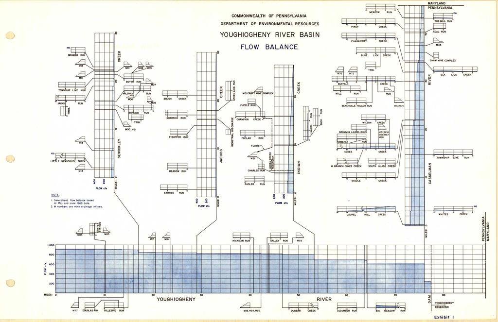
1 III-1 III BASIN DESCRIPTION The Youghiogheny Basin covers 1768 sq mi and extends from northern Maryland to McKeesport, Pennsylvania. This report deals only with the 1,255 sq mi of the basin within Pennsylvania and for purposes of this report the term Youghiogheny Basin means only that portion within Pennsylvania. The basin includes portions of four Pennsylvania counties: Allegheny, Fayette, Somerset, and Westmoreland. 1. RIVER SYSTEM The Youghiogheny is part of the Mississippi drainage system. It discharges to the Monongahela at McKee sport, approximately 16 river miles from the confluence of the Monongahela and the Allegheny Rivers. The main stem flows north from Maryland and enters the Youghiogheny Reservoir which extends from within Maryland to the dam near Confluence, Pennsylvania and approximately 5.5 miles north of the Maryland border. It then flows north to Confluence where it is joined by the Casselman River, thence northwest to Victoria and Ohiopyle, north to Indian Creek Station, west and north to South Connellsville and Connellsville, northwest to Dawson and Perryopolis, north to Smithton, north and west to Sutersville, north to South Versailles, west to White Oak and the southern tip of McKeesport and Versailles, and then northwest to Liberty, Port Vue and McKeesport. The main stem within Pennsylvania is 80 miles. It flows along the boundary line between Fayette and Westmoreland Counties, then through Westmoreland and then along the boundary between Allegheny and Westmoreland Counties. Major tributaries are: Casselman River, Indian Creek, Jacobs Creek and Sewickley Creek. Major sub-basin are listed in Table III-A together with drainage area of each, length of the main tributary and map reference locations along the main tributary. Relative locations of the tributaries and flows are shown on Exhibit 1.
2 III-2 Table III-A, Major Sub -basins of the Youghiogheny Basin Main Trib. Drainage Locations along main Length Area stream Sub-basin mi sq mi COUNTY: location Casselman River SOMERSET; Salisbury Meyersdale, Rockwood, Casselman, Confluence Indian Creek FAYETTE; Champion, Melcroft, Indian Head, Indian Creek Sta. WESTMORELAND; Jones Mills Jacobs Creek FAYETTE; Laurelville, Hammondville, Everson WESTMORELAND; Stauffer, Scottdale Sewickley Creek WESTMORELAND; Pleasant Unity,Youngwood, New Stanton, Hunkers, Yukon, Lowber, Gratztown Youghiogheny Main Stem SOMERSET - Confluence FAYETTE - Ohiopyle Connellsville, Dawson Perryopolis WESTMORELAND - Smithton, West Newton, Sutersville ALLEGHENY - Versailles, Liberty, Port Vue, McKeesport
3
4 III-4 2. RAINFALL AND RUNOFF Average annual precipitation varies throughout the watershed from a low of about 38 in. at the river mouth to 50 in. at Somerset, where the greatest annual precipitation of 66.6 in. was recorded in The overall average for the watershed is 43 in. per year. Distribution of rainfall throughout the basin is shown on page I. Appendix D. The lowland valleys receive the least amount and the uplands receive a maximum. June and July are the wettest months, and November is usually the driest. Based on a 25 year average of USGS data, a generalized balance of inflows, outflows and losses for the Youghiogheny Basin is as follows: billion gallons per year Inflows: Casselman River from Maryland 25 Youghiogheny River from Maryland Total surface inflow Precipitation in basin Total inflow 1,149 Outflow: Youghiogheny River to Monongahela (-)640 Evaporation and other losses POPULATION AND WATER USE Portions of the area and populations (1960 census) of the four counties included in the Youghiogheny watershed are estimated as follows: Youghiogheny Total Watershed County Sq Mi Population Sq Mi Population Allegheny 730 1,628, ,000 Fayette , ,000 Somerset 1,084 77, ,000 Westmoreland 1, , ,000 TOTAL YOUGHIOGHENY 1, ,000 1, ,000
5 III-5 Communities within the watershed with populations of over 5,000 are as follows: Communities Population Allegheny County: Elizabeth Township 14,159 McKeesport City 45,159 Port Vue Borough 6,635 White Oak Borough 9,047 Fayette County: Connellsville City 12,814 Dunbar Township 7,656 Washington Township 5,245 Somerset County: Somerset Borough 6,347 Westmoreland County: Greensburg City 17,383 Hempfield Township 12,421 Mt. Pleasant Borough 6,107 Rostraver Township 9,884 Scottsdale Borough 6,224 Sewickley Township 6,703 S. Huntington Township 6,073 Water resources of the Youghiogheny Basin are utilized for municipal and industrial water supply and recreation. While there appears to be no question as to adequacy of the quantity of water available, fuller development of the resources would require improvement of quality to both reduce water treatment costs and increase recreational use. A. Public Water Supply Public water supplies within the basin serve approximately 176,700 people with average consumption of 20 million gallons per day.
6 III-6 B. Lakes, Reservoirs and Fishing Streams The more significant lakes, reservoirs and fishing streams within the various sub-basins are as follows: Sewickley Creek sub-basin; -Unity Reservoir used solely for water supply, -Lonesome lake, boating Jacobs Creek sub-basin; -Westmoreland Water Authority reservoir one near Brush Creek and the Greenlick Reservoir, both are used for water supply -Meadow Run, includes an 8 mi stretch of recommended fishing stream Indian Creek sub-basin; -Indian Creek Reservoir, used for water supply -Indian Creek, includes a 6 mi stretch of recommended fishing stream Casselman River sub-basin; -Laurel Hill Lake, within Laurel Hill State Park, has a water area of 65 acres; used for fishing and boating and swimming -Lake Stonycreek, 250 acres; boating and fishing for property owners -Cranberry Glade Lake, 112 acres; fishing and boating Youghiogheny main stem sub-basin; -Youghiogheny Reservoir, portion within Pennsylvania is 2,172 acres; flood control, boating and fishing -Ohiopyle rapids on the Youghiogheny; used for white water boating. 4. RECREATIONAL DEVELOPMENT PROGRAMS All of the watershed is reasonably convenient to Pittsburgh area residents for recreation. Driving time from Pittsburgh is less than two hours to the furthest point and less than one hour to most of the watershed area. Recreational potential of the area is indicated by increasing attendance at State parks, planned development of additional park facilities and, federal recognition of scenic values and recreational potential. A. State Parks Attendance Acres Facilities * Laurel Hill , , ,302 B,C,F,H,P,R,S, Kooser , , ,304 C,FC, F,H,P,R,S, Ohiopyle 18, , , ,360 Being developed Laurel Ridge 15,000 17, Being developed * B-Boating F-Fishing R-Refreshment Concession C-Camping H-Hiking Trails S-Swimming FC - Family Cabins P-Picnicking
7 III-7 Ohiopyle and Laurel Ridge State Parks are being developed under Pennsylvania's Project 70 which is a master program to conserve and improve open space and natural resources and provide quality recreational facilities. Work at Ohiopyle started in Development will eventually provide greater recreational use of the river system for fishing, boating and white water boating at the Youghiogheny rapids. Also, adjacent to Ohiopyle, at Bear Run, the Western Pennsylvania Conservancy maintains 7,000 acres including a famous Frank Lloyd Wright house, Falling Waters, an important attraction in the area. Planned development of Laurel Ridge will provide a scenic trail some 55 miles long stretching along the ridge from the Youghiogheny. The park will consist of some 15, 000 acres, most of which is within the Youghiogheny basin. Plans include development of facilities for public enjoyment and preservation of natural characteristics along the crest of Laurel Ridge. B. Federal Recognition Two bills signed by the President in 1968 recognized that the natural characteristics and recreational potential of the Youghiogheny basin were worthy of consideration for development under federal programs. Public Law , Wild and Scenic Rivers Act, listed the Youghiogheny River as one to be studied for possible designation as a scenic river. Public Law , National Trails Systems Act, directed the Department of Interior to study the Potomac Heritage Trail. This would be an 825 mile trail beginning at Washington, D. C. and terminating at Ohiopyle State Park with the last portion running along the Youghiogheny from Connellsville to Ohiopyle. This hiking trail would connect with Pennsylvania's planned Laurel Ridge Trail.
FAYETTE COUNTY. Fayette County Active Transportation Profile REGIONAL ACTIVE TRANSPORTATION PLAN FOR SOUTHWESTERN PENNSYLVANIA
 REGIONAL ACTIVE TRANSPORTATION PLAN FOR SOUTHWESTERN PENNSYLVANIA 1 2 ACTIVE TRANSPORTATION AT A GLANCE Trails + Bike Routes 4 miles 73 miles 130 miles 90 miles Parkland Parkland Trail Off Street Trail
This is a digital document from the collections of the Wyoming Water Resources Data System (WRDS) Library.
 Library.") This is a digital document from the collections of the Wyoming Water Resources Data System (WRDS) Library. For additional information about this document and the document conversion process, please contact
This is a digital document from the collections of the Wyoming Water Resources Data System (WRDS) Library. For additional information about this document and the document conversion process, please contact
Multi-Jurisdictional Hazard Mitigation Plan
 Flooding General Flooding is the leading cause of death among all types of natural disasters throughout the United States, with its ability to roll boulders the size of cars, tear out trees, and destroy
ALLEGHENY COUNTY. Allegheny County Active Transportation Profile 2017 REGIONAL ACTIVE TRANSPORTATION PLAN FOR SOUTHWESTERN PENNSYLVANIA
 REGIONAL ACTIVE TRANSPORTATION PLAN FOR SOUTHWESTERN PENNSYLVANIA 1 2 ACTIVE TRANSPORTATION AT A GLANCE Trails + Bike Routes 123miles 132 miles 281 miles 75 miles 3 FACILITIES Facility Metrics (not including
ALLEGHENY COUNTY. Allegheny County Active Transportation Profile REGIONAL ACTIVE TRANSPORTATION PLAN FOR SOUTHWESTERN PENNSYLVANIA
 REGIONAL ACTIVE TRANSPORTATION PLAN FOR SOUTHWESTERN PENNSYLVANIA 1 2 ACTIVE TRANSPORTATION AT A GLANCE Trails + Bike Routes 123 miles 132 miles 281 miles 75 miles 3 FACILITIES Facility Metrics (not including
Norwin. HOME FIELD ADVANTAGE Norwin Knights Baseball Team Competes on Improved, State-of-the-Art Field. School District News Page 37
 Norwin HOME FIELD ADVANTAGE Norwin Knights Baseball Team Competes on Improved, State-of-the-Art Field School District News Page 37 Special Section: Real Estate Pages 15 SUMMER 2017 icmags.com Norwin Summer
ADULT TROUT STOCKING
 PENNSYLVANIA S 2010 APPROVED TROUT WATERS ADULT TROUT STOCKING Allegheny, Butler, Fayette, Greene and Washington Counties Compliments of STATE SENATOR WAYNE D. FONTANA Serving the 42nd Senatorial District
ECTS Purpose & Needs. Exhibit Home-Based Work Trips Attracted to the Penn/Jeannette Area
 Exhibit 4.23 - Home-Based Work Trips Attracted to the Penn/Jeannette Area Exhibit 4.24 - Transit Use for Work Trips Attracted to the Penn/Jeannette Area Eastern Corridor Transit Study 61 Greensburg - and
Proposed Reclassification of Muskrat Creek, North Platte River Basin in Goshen County, Wyoming
 Proposed Reclassification of Muskrat Creek, North Platte River Basin in Goshen County, Wyoming October 25, 2010 Waterbody: Muskrat Creek - Mainstem of Muskrat Creek from its headwaters downstream to its
TROUT CREEK WATERSHED (Second Year of Snowline Data)
") Extent of Snow Cover During the 2002 Spring Freshet For the TROUT CREEK WATERSHED (Second Year of Snowline Data) (Penticton Forest District) 1.0 INTRODUCTION The extent of snow cover over a watershed basin
Extent of Snow Cover During the 2002 Spring Freshet For the TROUT CREEK WATERSHED (Second Year of Snowline Data) (Penticton Forest District) 1.0 INTRODUCTION The extent of snow cover over a watershed basin
Searsville Dam Removal
 Searsville Dam Removal A unique opportunity for all Presented by the Beyond Searsville Dam Coalition San Francisquito Creek flows into the San Francisco Bay near the Palo Alto Airport and Golf Course seen
Coldwater Heritage Partnership
 Coldwater Heritage Partnership To provide leadership, coordination, technical assistance, and funding support for the conservation and protection Pennsylvania s coldwater streams and wild trout populations.
Module 2 Narration What is a watershed?
 Module 2 Narration What is a watershed? Timing Key Narrative Snapshots a) 00:10 Every living thing relies on water to exist. But where does our water come from? The most natural place to look is upstream
Mill Creek/Rose Valley Watershed General Information Presented by Dr. Mel Zimmerman Lycoming College CWI
 Mill Creek/Rose Valley Watershed General Information Watershed Concerns Rose Valley Lake Areas of Interest Biodiversity of Interest in Rose Valley Lake Rose Valley Lake Bird Area Fishes of Rose Valley
APPENDIX 1 QUESTIONNAIRE RESULTS
 APPENDIX 1 QUESTIONNAIRE RESULTS NORTHERN BERKS REGION PLANNING QUESTIONNAIRE 1. From 1990 to 2000, the population of the Northern Berks Region grew from 11,810 to 13,372, a 13.2% increase. In the future,
3.0 Basin and Watershed Characteristics
 3.0 Basin and Watershed Characteristics 3.1 Basin Characteristics 3.1.1 Crystal Lake Crystal Lake, located in the cities of Burnsville and Lakeville (Dakota County), covers an area of approximately 292
Notice. Proposed Changes to List of Class A Wild Trout Waters April 2017
 Notice Proposed Changes to List of Class A Wild Waters April 07 The Fish and Boat Commission (Commission) is considering changes to its list of Class A Wild Streams. Under 58 Pa. Code 57.8a (relating to
The Chesapeake Bay as an Estuary: An introduction. Istvan A. Urcuyo Gettysburg College
 The Chesapeake Bay as an Estuary: An introduction. Istvan A. Urcuyo Gettysburg College The Chesapeake Bay -Native Americans resided on its shores since 8000 B.C. The Chesapeake Bay -Original Native American
Quemahoning Reservoir
 Pennsylvania Fish & Boat Commission Biologist Report Quemahoning Reservoir Somerset County May 2011 Trap Net, Gill Net and Electrofishing Survey Quemahoning Reservoir is an 899 acre impoundment located
Notice of Proposed Rulemaking. Title 58. Recreation Part II. Fish and Boat Commission Chapter 65 Special Fishing Regulations.
 Notice of Proposed Rulemaking COMMONWEALTH OF PENNSYLVANIA PENNSYLVANIA FISH AND BOAT COMMISSION Title 58. Recreation Part II. Fish and Boat Commission Chapter 65 Special Fishing Regulations Preamble The
INDEPENDENCE SEAPORT MUSEUM ACTIVITY PACKET
 INDEPENDENCE SEAPORT MUSEUM ACTIVITY PACKET Grades 6-8 Dear Teacher: We are so excited that you scheduled a visit to the Independence Seaport Museum with your class! To complement your students visit to
Upper/Lower Owl Creek Reservoir
 Upper/Lower Owl Creek Reservoir Schuylkill County 2018 Largemouth Bass Survey Upper Owl Creek Reservoir and Lower Owl Creek Reservoir are 67-acre and 26-acre impoundments, respectively, created by two
PROFILE OF SACRAMENTO RIVER, FREEPORT TO VERONA, CALIFORNIA,
 PROFILE OF SACRAMENTO RIVER, FREEPORT TO VERONA, CALIFORNIA, FLOOD OF FEBRUARY 1986 By J.C. Blodgett and J.B. Lucas U.S. GEOLOGICAL SURVEY Open-File Report 88-82 CO CM I m r-h CM Sacramento, California
Annual Report for Fiscal Year and Future Plans for the Tillamook Bay Watershed Council
 Annual Report for Fiscal Year 2012-2013 and Future Plans for the Tillamook Bay Watershed Council A report prepared for the Tillamook County Board of Commissioners August 2013 Table of Contents: Recently
Powder/Tongue River Basin Plan Available Surface Water Determination Task 3D
 Technical Memorandum Subject: Powder/Tongue River Basin Plan Available Surface Water Determination Task 3D Date: February 2002 Prepared by: HKM Engineering Inc. INTRODUCTION Spreadsheet water accounting
Downtown Lot with no Zoning WISDOM, MT
 Downtown Lot with no Zoning WISDOM, MT Katey Brandenberger, Sales Associate Katey.brandenberger@prumt.com Agent cell # (406) 370-3016 Office: (406) 689-3190 www.prumt.com Wisdom River Gallery PO Box 93
NATURAL RESOURCES PLAN
 NATURAL RESOURCES PLAN This plan begins with an evaluation of important natural resources in the Lehigh Valley and what should be done to protect them. Before a plan for development is proposed it is first
INDIANA REGIONAL GENERAL CONDITIONS FOR THE STATE OF INDIANA
 INDIANA REGIONAL GENERAL CONDITIONS FOR THE STATE OF INDIANA These regional conditions are in addition to but do not supersede the requirements in the Federal Register (Volume 82 No. 4 of January 6, 2017).
DOWNLOAD OR READ : THE DELAWARE RIVER WATER WAR PDF EBOOK EPUB MOBI
 DOWNLOAD OR READ : THE DELAWARE RIVER WATER WAR PDF EBOOK EPUB MOBI Page 1 Page 2 the delaware river water war the delaware river water pdf the delaware river water war The Delaware River is a major river
Sport Fishing Expenditures and Economic Impacts on Public Lands in Washington
 Sport Fishing Expenditures and Economic Impacts on Public Lands in Washington For: Northwest Sportfishing Industry Association By: Southwick Associates Released June 2015 PO Box 6435 Fernandina Beach,
Wisconsin s Citizen-Based Monitoring Partnership Program and Trout Unlimited Driftless Area Restoration Effort (TUDARE)
") Wisconsin s 2010-11 Citizen-Based Monitoring Partnership Program and Trout Unlimited Driftless Area Restoration Effort (TUDARE) TUDARE Stream Monitoring Sites Established in 2010-2011 Summary Prepared
Wisconsin s 2010-11 Citizen-Based Monitoring Partnership Program and Trout Unlimited Driftless Area Restoration Effort (TUDARE) TUDARE Stream Monitoring Sites Established in 2010-2011 Summary Prepared
! " # $ % & % & ' ( ) * +
 * +") !" #$%& %& '() *+ EnVision Manistee County Fact Book Manistee County Community Foundation Spring 2005 Natural Environment & Recreation Page 1 Commercial Lodging Many of Manistee County s visitors choose
!" #$%& %& '() *+ EnVision Manistee County Fact Book Manistee County Community Foundation Spring 2005 Natural Environment & Recreation Page 1 Commercial Lodging Many of Manistee County s visitors choose
Key Findings & Corridor Highlights
 The PA 358 Corridor Greenville to I-79 The PA 358 Corridor connects the Borough of Greenville in northwest Mercer County with I-79 to the east. For much of the way it follows the Shenango and Little Shenango
Quassaick Creek. Watershed Management Plan. Advisory Committee Meeting #3 July 20 th, 2012
 Quassaick Creek Watershed Management Plan Advisory Committee Meeting #3 July 20 th, 2012 Assessment Report Subwatershed Delineation Characterizes watershed based on Hydrology/Topography (primary) Land
CLAIBORNE LOCK AND DAM PERTINENT DATA
 CLAIBORNE LOCK AND DAM PERTINENT DATA GENERAL Location Clarke, Monroe, & Wilcox Counties, Alabama; Alabama River, river mile 72.5 Drainage area Millers Ferry to Claiborne sq. mi. 836 Total drainage area
Gamefish Assessment Report
 MINNESOTA DEPARTMENT OF NATURAL RESOURCES Gamefish Assessment Report Spring Gamefish Assessment on the Mississippi River from Little Falls to Brainerd, MN May 31 through June 4, 2013 River Miles 966 to
Pre-Application Document Kaweah Project (FERC Project No. 298)
") TABLE OF CONTENTS Page 3.12 Aesthetic Resources... 3.12-1 3.12.1 Information Sources... 3.12-1 3.12.2 Setting... 3.12-1 3.12.3 Project Facilities... 3.12-2 3.12.4 Previous Visual Resources Assessment...
TABLE OF CONTENTS Page 3.12 Aesthetic Resources... 3.12-1 3.12.1 Information Sources... 3.12-1 3.12.2 Setting... 3.12-1 3.12.3 Project Facilities... 3.12-2 3.12.4 Previous Visual Resources Assessment...
PThe 16,000 acre Pettyjohn Ranch is located on the west side of Tehama County twenty miles from Red Bluff, CA on Interstate
 PThe 16,000 acre Pettyjohn Ranch is located on the west side of Tehama County twenty miles from Red Bluff, CA on Interstate 5. It is surrounded by privately owned land and can be reached all year by paved
Executive Summary. Map 1. The Santa Clara River watershed with topography.
 Santa Clara River Steelhead Trout: Assessment and Recovery Opportunities December 2005 Prepared By: Matt Stoecker and Elise Kelley, Ph.D. University of California, Santa Barbara Prepared For: The Santa
Colusa Basin Drain Watershed Fish Stranding Tour Concept Paper Mike Hendrick and Brycen Swart NMFS
 Colusa Basin Drain Watershed Fish Stranding Tour Concept Paper Mike Hendrick and Brycen Swart NMFS On May 31, 2013 representatives from CDFW, USFWS, and NMFS went on a field tour to look at locations in
Water of the Rogue Valley
 Water of the Rogue Valley An Activity Book for Grades 3-5 Welcome! You are about to embark on a journey of exploration. Your adventure begins at school and continues at North Mountain Park. This workbook
The Lake Creek Ranch. Located in the foothills of the Owl Creek Mountains in western Hot Springs County, Wyoming
 The Lake Creek Ranch Located in the foothills of the Owl Creek Mountains in western Hot Springs County, Wyoming Experienced Professional Ranch Brokers Specializing in the sale of ranches, farms, & recreational
Swift Current Creek Watershed
 Swift Current Creek Watershed Watershed Boundary Gross drainage area 3939 km 2 973,343 acres Gross creek length 230 km 143 miles Primary water source for 20 000 people Major source of water base recreation
Shimmerhorn Ranch. Buford, Wyoming // Albany County
 Shimmerhorn Ranch Buford, Wyoming // Albany County The Shimmerhorn Ranch is located just off Interstate 80; it lies 20 miles east of Laramie, the home of the University of Wyoming, and 30 miles west of
Sport Fishing Expenditures and Economic Impacts on Public Lands in Oregon
 Sport Fishing Expenditures and Economic Impacts on Public Lands in Oregon For: Northwest Sportfishing Industry Association By: Southwick Associates October 2013 PO Box 6435 Fernandina Beach, FL32035 Tel
Visitor Guidelines for WPC-owned Properties. Last revised 5/20/2010
 WESTERN PENNSYLVANIA CONSERVANCY Visitor Guidelines for WPC-owned properties 800 Waterfront Dr., Pittsburgh, PA 15222 412-288-2777, www.waterlandlife.org Visitor Guidelines for WPC-owned Properties Last
Clinton River Assessment
 Dams Sub-watershed Big Beaver Creek (1) Clam Lake (3) Clinton River (23) Coon Creek (0) E. Br. Coon Creek (0) East Pond Creek (5) Galloway Creek (2) Gloede Ditch (1) Harrington Drain (0) Highbank Creek
Plan 6 Project. Stop the destructive discharges to the Northern Estuaries and Restore the River of Grass. Upper Chain of Lakes.
 Upper Chain of Lakes Plan 6 Project Lake Kissimmee Kissimmee River Indian River Lagoon Stop the destructive discharges to the Northern Estuaries and Restore the River of Grass Caloosahatchee Estuary Lake
Outline. 1. Overview 2. Population 3. Flooding 4. Land Use 5. References. Overview
 Outline 1. Overview 2. Population 3. Flooding 4. Land Use 5. References Overview The two main rivers in the Cannon River watershed are the Cannon and Straight Rivers. The Cannon River originates in Shields
MIDWEST REALTY GROUP
 Lost Lake Recreation Camp 4930 Lake Station, Freeman, MI 48622 2,320 Acres of Recreational Land Rick DeKam, CCIM Mobile: (269) 207-5430 Email: rick@midwestrealty.com Andrew Gyorkos Mobile: (269) 760-5201
Notice. Classification of Wild Trout Streams Proposed Additions and Revisions January 2019
 Notice Classification of Wild Trout Streams Proposed Additions and Revisions January 2019 Under 58 Pa. Code 57.11 (relating to listing of wild trout streams), it is the policy of the Fish and Boat Commission
Eric Jones Fish Hatchery Manager II Ca. Dept. of Fish & Wildlife
 Mount Shasta Hatchery 2014 Photo courtesy of M. Dege Eric Jones Fish Hatchery Manager II Ca. Dept. of Fish & Wildlife McCloud River Redband trout reared at Mt. Shasta Hatchery About MSH Why were the redbands
DARLINGTON, LITTLE BEAVER CREEK
 COUNTY PROJECT NAME ALLEGHENY SHALER TOWNSHIP, PINE CREEK; Phase 2 & 3 ALLEGHENY BETHEL PARK, MCLAUGHLIN RUN ALLEGHENY TURTLE CREEK BORO, SAWMILL CREEK ALLEGHENY BALDWIN, UT LICK RUN BEAVER DARLINGTON,
Quay County, New Mexico 160 deeded acres; (MOL) $420,000
 $420,000") Quay County, New Mexico 160 deeded acres; (MOL) $420,000 Turn your steers out and watch them gain! FARMING House Ranch offers 60 acres of water rights This region of New Mexico just east of Tucumcaro
Quay County, New Mexico 160 deeded acres; (MOL) $420,000 Turn your steers out and watch them gain! FARMING House Ranch offers 60 acres of water rights This region of New Mexico just east of Tucumcaro
ORDINANCE NO. SB-3131
 ORDINANCE NO. SB-3131 AN ORDINANCE MAKING FINDINGS AND ESTABLISHING A STAR BOND PROJECT DISTRICT WITHIN THE CITY OF OVERLAND PARK, KANSAS PURSUANT TO K.S.A. 12-17,160 ET SEQ., AS AMENDED (BLUHAWK STAR
Ontonagon River Assessment
 Urban/Industrial.1% Open water 4.5% Wetland 15.% Barren.6% Agriculture 5.4% Grassland.2% Forest 74.2% Figure 19. Percent land use in the Ontonagon River watershed. Michigan data from Michigan 1992 NLCD
Spearfish Canyon State Park & Bismarck Lake
 Spearfish Canyon State Park & Bismarck Lake Land Exchange Between the U.S. Forest Service and the State of South Dakota July 12, 2016 Background In 2006, the State of South Dakota received title to several
Wildlife Introduction
 Wildlife Introduction The wildlife section of this chapter is divided into sections for various habitats and groups of species. Old growth, snags and downed wood, and riparian areas are unique habitats
The Department's authority to administer the ownership of navigable water bodies is referenced in the following:
 NAVIGABLE WATER WAYS OWNED BY THE STATE OF MONTANA AND ADMINISTERED BY THE DEPARTMENT OF NATURAL RESOURCES AND CONSERVATION TRUST LAND MANAGEMENT DIVISION May 14, 2014 Subject to Update The State of Montana
Appendix H Recreation and Tourism (Chapter 8) Contents. List of Tables
 Contents. List of Tables") Appendix H Recreation and Tourism (Chapter 8) Contents Trends Data... H-2 CA DMV records... H-2 CA DFG Hunting/Fishing Licenses... H-2 USDA Agricultural Tourism... H-4 United States Forest Service... H-6
Appendix H Recreation and Tourism (Chapter 8) Contents Trends Data... H-2 CA DMV records... H-2 CA DFG Hunting/Fishing Licenses... H-2 USDA Agricultural Tourism... H-4 United States Forest Service... H-6
62. Gulkana River, Main Fork, Middle Fork, and West Fork
 62. Gulkana River, Main Fork, Middle Fork, and West Fork The Gulkana, a National Wild and Scenic River, is one of Alaska s most popular whitewater rivers because of its road accessibility and because of
Beaver Valley Ranch Steamboat Springs, Colorado
 Beaver Valley Ranch Steamboat Springs, Colorado Introduction Hidden in the heart of one of Colorado s last unspoiled mountain valleys, Beaver Valley Ranch is tailor-made for hunting and fishing of exceptional
ORDINANCE NO CITY OF MONTICELLO ADOPTING TAX INCREMENT FINANCING TAX INCREMENT FINANCING DISTRICT II
 ORDINANCE NO. 2006-59 CITY OF MONTICELLO ADOPTING TAX INCREMENT FINANCING TAX INCREMENT FINANCING DISTRICT II WHEREAS, the City of Monticello, Illinois, desires to adopt tax increment financing pursuant
Pigs Gun Club INTERMOUNTAIN REALTY GROUP. A Family Hunting Haven
 Pigs Gun Club A Family Hunting Haven Sanpete County, Utah 554 Acres $1,448,000 INTERMOUNTAIN REALTY GROUP 4543 S Holladay Blvd., Salt Lake City, Utah, 84117 801-277-0800 www.intermountainrealtygroup.com
2015 Annual Report. February 15, 2016
 2015 Annual Report February 15, 2016 2015 Round Lake Management Commission (RLMC) Annual Report Contents The Round Lake Mgt Commission 2015 Year in Review Huebner Fishery Mgt Foundation Shoreline Restoration
Illinois State Water Survey
 Illinois State Water Survey HYDROLOGY DIVISION SWS Contract Report 508 COMPARISON OF 1987 AND 1989 BED PROFILE SURVEYS OF THE LOWER CACHE RIVER by Richard Allgire Office of Sediment and Wetland Studies
Cranberry Area Transit Study Steering Committee Meeting
 Steering Committee Meeting Thursday, Meeting No. 1 Minutes by Jamie L. Brush The Steering Committee held its first meeting on Thursday, from 1:00-3:00 PM at the Cranberry Township Municipal Building. The
UNITED STATES OF AMERICA FEDERAL ENERGY REGULATORY COMMISSION. Morrisville Water & Light FERC No. P-2629 Morrisville Project Green River Development
 UNITED STATES OF AMERICA FEDERAL ENERGY REGULATORY COMMISSION Morrisville Water & Light FERC No. P-2629 Morrisville Project Green River Development AMERICAN WHITEWATER AND VERMONT PADDLERS CLUB MOTION
OFFICE OF STRUCTURES MANUAL FOR HYDROLOGIC AND HYDRAULIC DESIGN CHAPTER 11 APPENDIX B TIDEROUT 2 USERS MANUAL
 OFFICE OF STRUCTURES MANUAL FOR HYDROLOGIC AND HYDRAULIC DESIGN CHAPTER 11 APPENDIX B TIDEROUT 2 USERS MANUAL APRIL 2011 APRIL 2011 Page 1 Preface TIDEROUT 2, Build 1.22 dated June 29, 2006 is the current
STREAM SURVEY File form No..
 scanned for KRIS THE RESOURCES AGENCY OF CALIFORNIA California Department of Fish and Game STREAM SURVEY File form No.. Date: September 4, 1969. NAME: North Fork Schooner Gulch Creek COUNTY: Mendocino.
Bicycle and Pedestrian Facilities Toolbox (Excerpt from Figure 3.1)
") Appendix B Neighborhood Connections Summaries This Appendix is a supplement to the information presented in Chapter 3 Connect People. The Appendix includes a summary or profile for each of the proposed
Appendix B Neighborhood Connections Summaries This Appendix is a supplement to the information presented in Chapter 3 Connect People. The Appendix includes a summary or profile for each of the proposed
Hard Hat Services ph: hardhatinc.com 932 N. Wright St., Suite 160 Naperville, IL 60563
 Interstate Power and Light Company Ottumwa Generation Station CCR Surface Impoundment Annual Inspection Report 154.018.012.003 Report issued: December 21, 2016 Hard Hat Services ph: 877-630-7428 hardhatinc.com
Stonycreek Rendezvous
 Stonycreek Rendezvous Friday, May 20 **You must have a wristband to enter Greenhouse Park** Class II/III Downriver Race Registration 5:30 at Carpenters Park 6:30-Carpenters Park to Greenhouse Park Music
John Fletcher Vann was born in Madison County in East Texas in His parents died at a young age and he was
 Subject Sb tt to os sale,,w withdrawal, wal,o or re error. ro r. The Vann Ranch is located on the Colorado River at the head waters of Lake Buchanan, just south of the Colorado Bend State Park. This scenic
US Sugar Land Purchase, River of Grass Project, SugarHill Sector Plan, Amendment 1
 US Sugar Land Purchase, River of Grass Project, SugarHill Sector Plan, Amendment 1 Rivers Coalition September 24, 2014 Upper Chain of Lakes Lake Kissimmee Kissimmee River Caloosahatchee Estuary Lake Okeechobee
Notice. Proposed Changes to List of Class A Wild Trout Waters January 2019
 Notice Proposed Changes to List of Class A Wild Waters January 209 The Fish and Boat Commission (Commission) is considering changes to its list of Class A Wild Streams. Under 58 Pa. Code 57.8a (relating
$123, /- Acres. Blount County, AL. Sean Brown Office: Cell: Fax:
 mulberry@fork river@runs through@it@tract 21 +/- Acres Blount County, AL $123,000 National Land Realty 9 N. Conception St. Mobile, AL 36602 www.nationalland.com Sean Brown Office: 855.657.5263 Cell: 205.531.9221
MINNESOTA DEPARTMENT OF NATURAL RESOURCES DIVISION OF FISHERIES AND WILDLIFE. Gamefish Assessment Report
 Minnesota DNR F-29-R(P) Area F312 February 1, 2013 MINNESOTA DEPARTMENT OF NATURAL RESOURCES DIVISION OF FISHERIES AND WILDLIFE Gamefish Assessment Report Spring Gamefish Assessment on the Mississippi
6TH PELLETIER BROOK LAKE T15 R9, Aroostook Co. U.S.G.S. Gardner Pond, Maine (7 1/2 )
") 6TH PELLETIER BROOK LAKE T15 R9, Aroostook Co. U.S.G.S. Gardner Pond, Maine (7 1/2 ) Fishes Brook trout Minnows Blacknose dace Pearl dace Physical Characteristics Area - 27 acres Average depth - 2 feet
6TH PELLETIER BROOK LAKE T15 R9, Aroostook Co. U.S.G.S. Gardner Pond, Maine (7 1/2 ) Fishes Brook trout Minnows Blacknose dace Pearl dace Physical Characteristics Area - 27 acres Average depth - 2 feet
2.0 Existing Conditions
 20 2.0 Existing Conditions 2.1 Land Use, Future Growth Patterns, Physical Barriers Geographic Overview Sutter County s land use pattern is characterized by extensive agricultural areas, significant natural
EXTENT OF OBSERVATION
 scanned for KRIS THE RESOURCES AGENCY OF CALIFORNIA Department of Fish and Game STREAM SURVEY Date: May 25 and 31, 1977. NAME: Unnamed Stream (Tributary to Sonoma Creek) COUNTY: Sonoma. STREAM SECTION:
Public Notice. Corps File No. LRE Date: March 19, 2017 Expires: March 18, 2022
 US Army Corps of Engineers Detroit District Public Notice Corps File No. LRE-2016-00006-100 Date: March 19, 2017 Expires: March 18, 2022 PUBLIC NOTICE ANNOUNCING REGIONAL CONDITIONS AND WATER QUALITY CERTIFICATIONS
Massawepie Trek Center Scouting s Adirondacks High Adventure Base Camp Do You Have What It Takes? 2018 Treks
 Massawepie Trek Center Scouting s Adirondacks High Adventure Base Camp Do You Have What It Takes? 2018 Treks Young men and women can test their skills on one of the 10 High Adventure Treks in the beautiful
Susquehanna River Walleye Fishery
 Susquehanna River Walleye Fishery 2008 The Susquehanna River is the largest tributary to the Atlantic Ocean lying completely within the United States. It originates from the outlet of Otsego Lake in Cooperstown,
2014 PA Resident Survey
 2014 PA Resident Survey Purpose: Understand outdoor recreation patterns and opinions regarding future recreation land conservation, facility development and management Provide a snapshot of where Pennsylvanians
WFC 50 California s Wild Vertebrates Jan. 11, Inland Waters (Lakes and Streams) Lisa Thompson
 Lisa Thompson") Inland Waters: Lakes and Streams WFC 50 11 January 2011 Lisa Thompson Fisheries Extension Specialist Wildlife, Fish, & Conservation Biology Department University of California, Davis Take home messages
Inland Waters: Lakes and Streams WFC 50 11 January 2011 Lisa Thompson Fisheries Extension Specialist Wildlife, Fish, & Conservation Biology Department University of California, Davis Take home messages
Ra ccoon River s Iowa. 1. Region surrounding the river. There are no extensive stands of commerical timber.
 Ra ccoon River s Iowa 1. Region surrounding the river a. The Raccoon River flows from its source in Buena Vista County along the western edge of the Wisconsin drift region in a general southeasterly direction
Final Report August 2005
 2.0 REGIONAL STUDY AREA 2.1 Regional Setting 2.1.1 Topography The Los Angeles Region is located within the western portion of the Transverse Ranges Geomorphic Province. The San Andreas transform fault
Crook Ranch. Tehama County, California. Proudly Offered By
 Crook Ranch Tehama County, California Proudly Offered By 707 Merchant Street, Suite 100, Vacaville, Ca 95688 (707) 455-4444 Office (707) 455-0455 Fax info@caoutdoorproperties.com www.californiaoutdoorproperties.com
Salmon River Cooperative Noxious Weed Program (CNWP) Presented by the Salmon River Restoration Council
 Presented by the Salmon River Restoration Council") Salmon River Cooperative Noxious Weed Program (CNWP) Presented by the Salmon River Restoration Council Some of you may be thinking So where is Salmon River? Isn t it in Idaho, Washington, or Oregon? The
Salmon River Cooperative Noxious Weed Program (CNWP) Presented by the Salmon River Restoration Council Some of you may be thinking So where is Salmon River? Isn t it in Idaho, Washington, or Oregon? The
Earth WEEK The Maumee Matters. Save Maumee Grassroots Organization. April 18 through April presents
 Save Maumee Grassroots Organization presents The Maumee Matters Earth WEEK 2014 April 18 through April 26 2014 because one day is just not long enough Everything Water:The Maumee Matters Earth Week 2014
Proposed Reclassification of Cherry Creek, North Platte River Basin, Wyoming. October 25, 2010
 Proposed Reclassification of Cherry Creek, North Platte River Basin, Wyoming October 25, 2010 Waterbody: Location: Tributary to: Cherry Creek - Mainstem from headwaters downstream to the confluence with
Appalachian Adventure Unguided Tour #5
 Appalachian Adventure Unguided Tour #5 (44 mi, approximately 1hr 27 min driving time) Our 3-Dam tour provides for a short, leisurely drive to the Fontana, Santeetlah and Cheoah Dams using some interesting
SUN RIVER RANCH Vaughn, Montana
 SUN RIVER RANCH Vaughn, Montana CLICK HERE FOR A PRINTER-FRIENDLY PDF LOCATION: The Sun River Ranch is located seven miles west of Vaughn, Montana, off Highway 89 in the Sun River Valley. Great Falls,
Warden Tom Kasnick August 30, 1983
 scanned for KRIS Franz Creek Warden Tom Kasnick August 30, 1983 - Region 3 Franz Creek, Sonoma County - Fish Kill and Pollution Incident On August 3, 1983, you requested that I investigate a reported fish
Management Plan for the Obey River Trout Fishery
 Management Plan for the Obey River Trout Fishery 28-214 By: James Travis Scott Jack Swearengin Walter Scott Webb D.W. Young Tennessee Wildlife Resources Agency January 28 Management Plan for the Obey River
Iowa Department of Natural Resources Iowa Water Trails Grant Program
 Iowa Department of Natural Resources Iowa Water Trails Grant Program Submitted by the City of Story City in conjunction with the Skunk River Paddlers and the Story County Conservation Board Tuesday, January
Reservoir Ranch Dillon, Montana
 Reservoir Ranch Dillon, Montana Clifton M. Berglee, D.V.M. (Listing Broker) 406-860-7319 cell cberglee@montwyowest.com Phone: (406) 628-2341 (office) Website: montwyowest.com P.O. Box 578, Laurel, Montana
Broken Bar W Ranch TETON VALLEY, IDAHO. Hunting Ranching Fly Fishing Conservation
 Broken Bar W Ranch TETON VALLEY, IDAHO Hunting Ranching Fly Fishing Conservation Broken Bar W Ranch TETON VALLEY, IDAHO Introduction: The Broken Bar W Ranch is located in Driggs, Idaho, the county seat
Analysis of 2015 Trail Usage Patterns along the Great Allegheny Passage
 Analysis of 2015 Trail Usage Patterns along the Great Allegheny Passage Prepared for the Allegheny Trail Alliance, August 2016 By Dr. Andrew R. Herr Associate Professor of Economics Saint Vincent College