U.S. Army Corps of Engineers
|
|
|
- Christina Powell
- 6 years ago
- Views:
Transcription
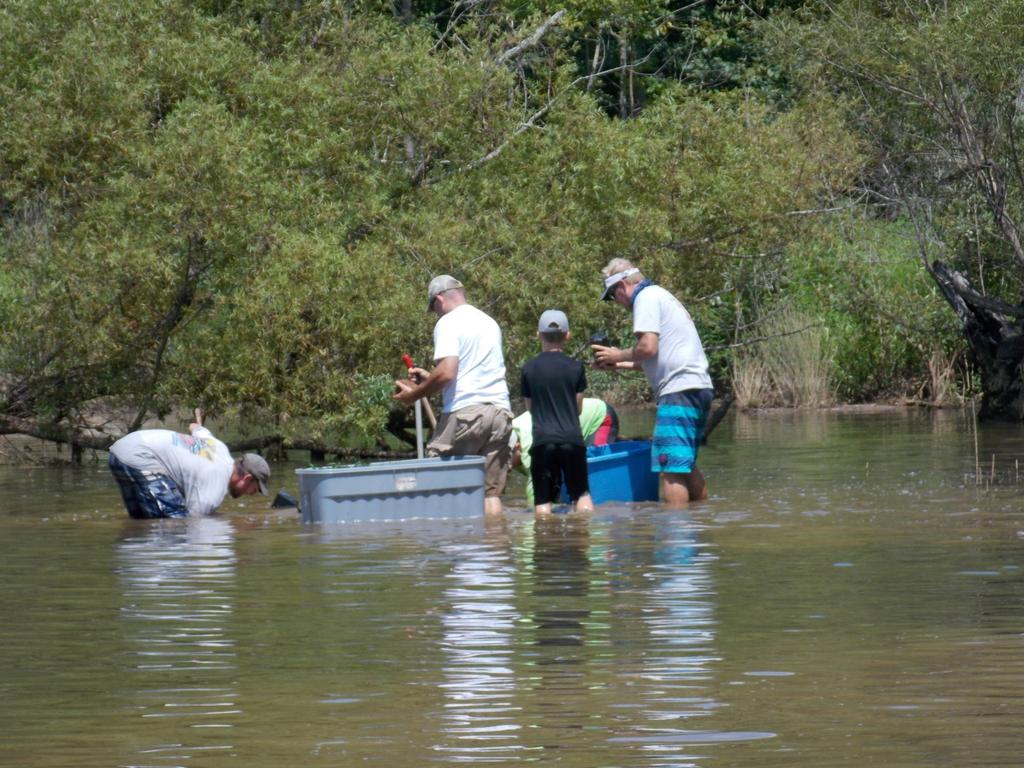
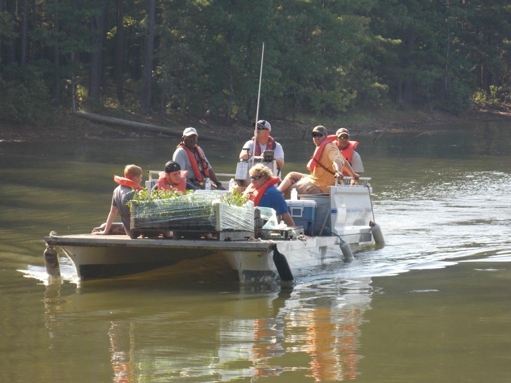
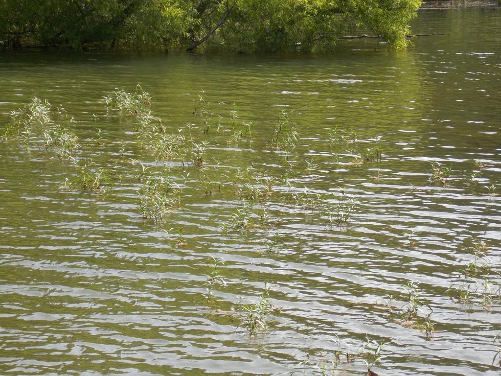
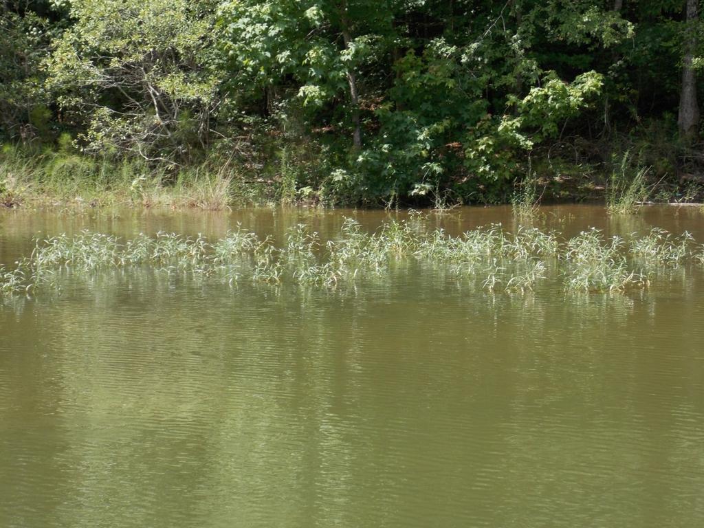
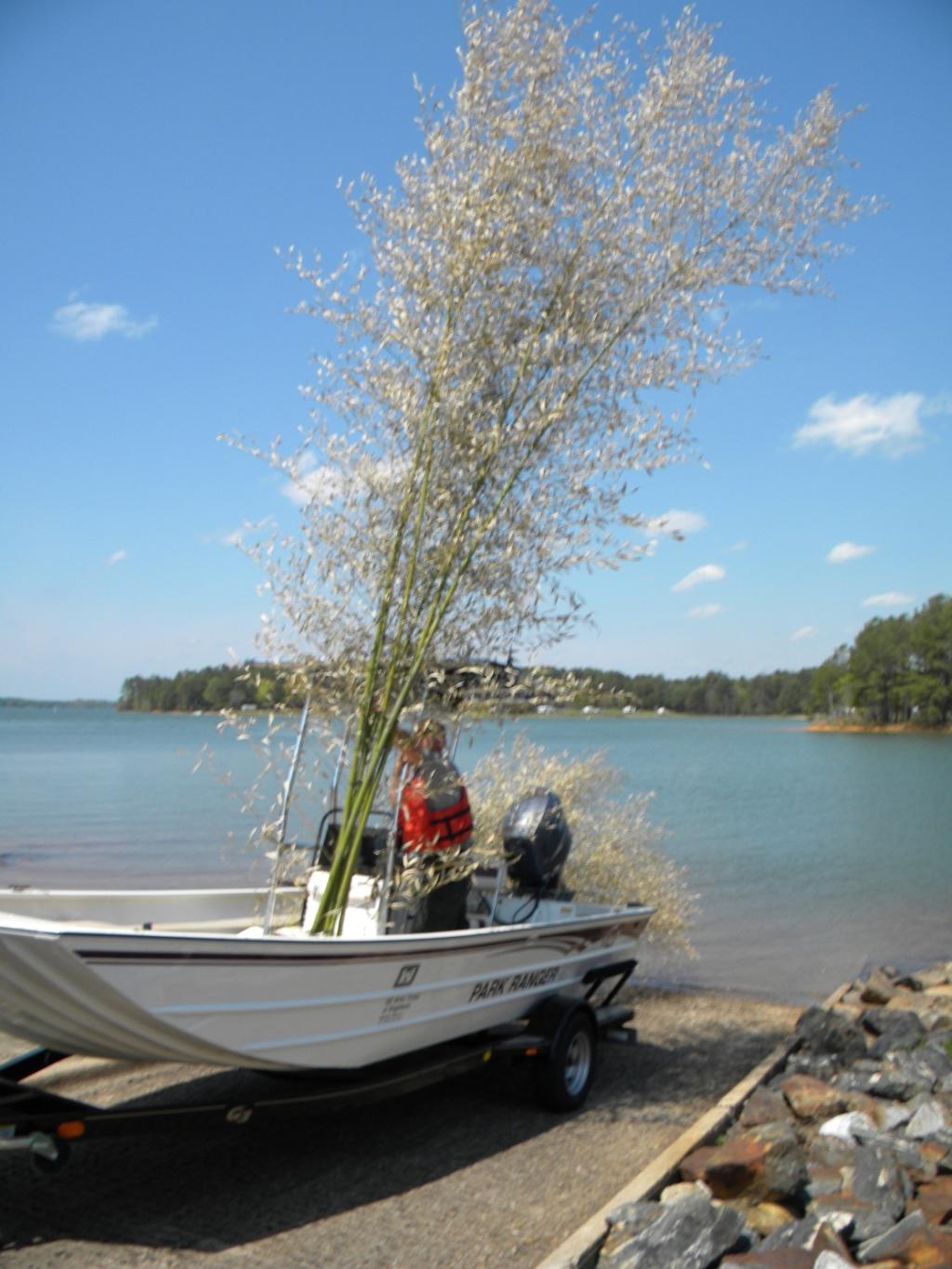
1 A. U.S. Army Corps of Engineers Kevin Parsons, Natural Resources Specialist 500 Resource Management Drive West Point, GA B. Underwater Structure Enhancement for West Point Project West Point Lake, Southern Appalachians Region 3 rd Congressional District of Georgia June 1, 2016 September 30, 2016 Georgia Department of Natural Resources, Georgia BASS Nation, Troup County High FFA C. 1. The purpose of this project is to enhance the underwater structure, or lack thereof, by planting American Water-willow as well as adding artificial habitat and fish attractors to various locations around West Point Lake (WPL). Currently, WPL has limited structure for fish species to utilize. While there is moderate structure around the lake this can be improved upon greatly. The plan for WPL, with the help of the Georgia Department of Natural Resources (GA DNR) and the Georgia BASS Nation (GBN), is to plant 25 American Water-willow sites. American Water-willow is a perennial non-invasive plant that is native to Georgia. It is a rooted plant that grows in shallow water usually from the shoreline out to about five feet deep. It provides great habitat for juvenile and adult fish of many species and can help stabilize shorelines. Once it is established it can spread to other areas from seed or by breaking loose and rooting elsewhere. This will help establish new areas of habitat. Once the America Water-willows are planted, they will be wired down to prevent them from being uprooted until they are established. Several sites have already been planted and around 70% have taken root and are doing well. The GA DNR has planted American Water-willow on several Georgia Power Lakes, which include Lake Oconee and Lake Jackson, and on Lake Richard B. Russell which is a Corp of Engineers lake. GA DNR has had great success on these bodies of water. The second part of this project is to build around 200 fish attractors out of bamboo, five gallon buckets, and concrete with the help of volunteers from Troup County High FFA Organization. Once the attractors are built, they will be taken by boat to designated locations that need structure added to them. Some of these areas are marked with buoys that read Fish Attractor on the side, while other areas need to be marked with new fish
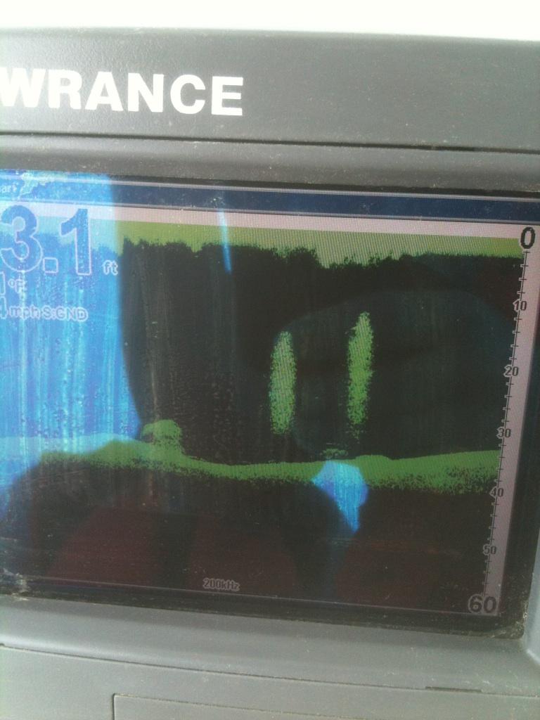
2 attractor buoys. Each area designated will support approximately three to five surface acres at depths around 20 to 30 feet. 2. This project has three main goals. The first goal is to provide fish species with needed habitat that will enhance the fish population. Second, planting Water-willow and installing fish attractors will help entice more fishermen to utilize WPL and help the local economy. The third goal of this project is to have local high school students volunteer which will stimulate students interest in the outdoors and natural resource management and encourages them to consider careers related to natural resources. Several high school bass fishing teams have already volunteered with planting Water-willow on West Point Lake. In addition, the Troup County High FFA has assisted rangers in the construction of artificial habitat. To monitor the sites, down and side scan sonar will be used to check fish numbers around the structures at least once a month for a one year period. Sonar will also be used to determine if additional structure needs to be added to the sites. D. 3. By having local high school students volunteer they will have a better knowledge and understanding of fish behavior and habitat requirements. Students will also be able to fulfill requirements for organizations that they are members of, such as FFA. Since WPL is considered by many to be a fishing lake, the addition of attractors will only encourage more fishermen to visit the area. As a result the local economy will benefit from these fishermen staying in hotels around the area, staying in campgrounds, buying bait and tackle, groceries, fuel, purchasing fishing licenses, and eating at local restaurants. A 2007 study found that WPL attributes $535 million each year to the region s economy and is the biggest tourist attraction in the area. 4. Sites that do not have buoys to mark them will be marked so. This way fishermen and boaters in general, will be aware of underwater structure on WPL. The sites will be monitored to determine if and additional structure is needed on a yearly basis. 5. No special permits are required. 6. The start of this project is June 1, 2016 and is to be completed before September 30, These dates are flexible depending on the allocation of funds and award date. 1. An amount of $ is requested for the purchase of Water-willow plants, buoys, concrete, and buckets. 2. Categories Reservoir Fisheries Habitat Partnership Personnel Staff Partner Contribution Amount Type of Contribution (cash or in-kind) Timeline (anticipated date of expenditures)
3 Volunteers Fringe Travel Equipment* Supplies $6, Cash June 2, 2016 Contractual Other US Army Corps of Engineers Personnel Staff $3, In-kind July 10, 2016 Volunteers Fringe Travel Equipment* Supplies Contractual Other Georgia Department of Natural Resources Personnel $ In-kind July 25, 2016 Staff Volunteers Fringe Travel Equipment* Supplies Contractual Other GA BASS Nation Personnel Staff Volunteers $3, In-kind July 25, 2016 Fringe Travel Equipment* Supplies Contractual Other Troup High FFA Personnel Staff Volunteers $1, In-kind September 15, 2016 Fringe Travel Equipment*

4 Supplies Total $15, An amount of $ is being requested to purchase ten Fish Attractor buoys which will cost approximately $ each, which includes shipping costs, totaling $ An additional $ is needed to purchase 75, 80 lb bags of Quickcrete at $3.29 per bag plus tax. Around $ will be used for fuel for the barge that will be used to take attractors to their site. The remaining balance will be used to purchase additional buckets to the stock of buckets already present. 4. An amount of $ is requested for the purchase of Water willow plants.

5 The yellow pins represent the location of the fish attractor sites.

6 Water-willow planting sites are designated with yellow pins.

7 Water-willow planting sites are designated with yellow pins.
8 West Point Lake Fish Attractor Coordinates Fish Attractor Latitude Longitude Comments MC-01 N 32 57' 00.7" 25.2" Maple Cr., Large structure, natural materials. MC-02 N 32 56' 59.1" 08.9" Maple Cr., Large structure, natural materials. MC-03 N 32 57' 09.4" 52.5" Maple Cr., Large structure, natural materials. MC-04 N 32 57' 34.7" 10.9" Maple Cr., Large structure, natural materials. MC-05 N 32 56' 33.2" 44.2" Maple Cr., Large structure, natural materials. MC-06 N 32 56' 39.6" 47.0" Maple Cr., Large structure, natural materials. BV-01 N 32 57' 12.6" W 85 12' 32.5" Burnt Village, Large structure, natural materials. RC-01 N 33 01' 51.6" 37.3" Main River, Smaller structure, artificial materials. RC-02 N 33 02' 14.2" 00.9" Main River, Smaller structure, artificial materials. RC-03 N 33 02' 44.3" 00.2" Main River, Smaller structure, artificial materials. RC-04 N 33 02' 54.8" W 85 08' 28.4" Main River, Smaller structure, artificial materials. RC-05 N 33 03' 18.0" W 85 07' 21.6" Main River, Smaller structure, artificial materials. RC-06 N 33 03' 27.0" W 85 06' 56.3" Main River, Smaller structure, artificial materials. RC-07 N 33 03' 50.5" W 85 07' 43.8" Main River, Large structure, Unknown materials RC-08 N 33 03' 45.0" W 85 08' 17.9" Smaller structure comprised of artificial materials. WWC-01 N 33 04' 20.9" W 85 08' 34.6" Whitewater cr., Large structure, Unknown materials WWC-02 N 33 03' 38.5" 54.2" Whitewater cr., Smaller structure, artificial materials. RC-09 N 33 01' 37.2" 40.44" Between Pyne Rd. boat ramp and HWY 109. RC-10 N 33 01' 7.56" 44.28" Out from 2nd dock at Pyne Rd park. WC-01 N 33 01' 9.48" 10.68" Wilson Creek. South of beach at Pyne Rd park. WC-02 N 33 00' 40.14" 56.16" Wilson Creek. Near island out from Pyne Rd Park. RC-11 N 33 00' 52.02" 55.26" Out from shoals at Whitetail Ridge Campground RC-12 N 33 00' 14.16" 43.26" Out from Glass Bridge Park. RC-13 N 33 00' 3.96" 33.12" Out from Glass Bridge Park. Southern most part.

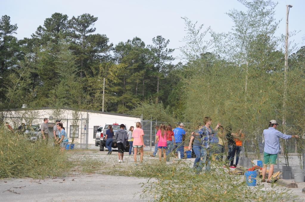
9 EC-01 EC-02 YJ-01 YJ-02 N 32 59' 49.26" N 32 59' 29.58" N 33 04' 30.82" N 33 05' 23.63" 18.96" In Rainbow Creek near Earl Cook Boat ramp " Out from Earl Cook Beach. W 85 05' 06.63" Main Channel of Yellowjacket Creek W 85 03' 59.64" Yellowjacket Creek and Dixie Creek Intersection 4. Below are pictures of the current water willow habitat project currently being done by the Georgia BASS Nation, U.S. Army Corps of Engineers, and the Georgia Department of Natural Resources. We would like to expand on this project for several more years to provide critical shoreline habitat for juvenile fish species.
10
11
12
13

14
Estimated on-the-ground start and end dates: 1 June October 2018
 A. Applicant Information Name of Organization: U.S. Army Corps of Engineers, Carlyle Lake 801 Lake Road, Carlyle, IL 62231 Contact Information: Robert Wilkins, Operations Manager, (618) 594-2484, Robert.Wilkins@usace.army.mil
U.S. Army Corps of Engineers (USACE) P.O. Box 428 Smithville, MO
 P.O. Box 428 Smithville, MO") Applicant Information United States Army Corps of Engineers Kansas City District Principal Contact: Derek Dorsey, Natural Resource Manager U.S. Army Corps of Engineers P.O. Box 428 Smithville, MO 64089
Applicant Information United States Army Corps of Engineers Kansas City District Principal Contact: Derek Dorsey, Natural Resource Manager U.S. Army Corps of Engineers P.O. Box 428 Smithville, MO 64089
DALE HOLLOW LAKE TROOPER ISLAND IMPROVEMENT PROJECT Proposal for Reservoir Fisheries Habitat Partnership (RFHP)
") DALE HOLLOW LAKE TROOPER ISLAND IMPROVEMENT PROJECT Proposal for Reservoir Fisheries Habitat Partnership (RFHP) A. Applicant Information: US Army Corps of Engineers, Dale Hollow Lake POC: Gregg Nivens
DALE HOLLOW LAKE TROOPER ISLAND IMPROVEMENT PROJECT Proposal for Reservoir Fisheries Habitat Partnership (RFHP) A. Applicant Information: US Army Corps of Engineers, Dale Hollow Lake POC: Gregg Nivens
NEVADA DEPARTMENT OF WILDLIFE STATEWIDE FISHERIES MANAGEMENT
 NEVADA DEPARTMENT OF WILDLIFE STATEWIDE FISHERIES MANAGEMENT FEDERAL AID JOB PROGRESS REPORTS F-20-48 2012 RYE PATCH RESERVOIR WESTERN REGION NEVADA DEPARTMENT OF WILDLIFE, FISHERIES DIVISION JOB PROGRESS
JadEco, LLC PO BOX 445 Shannon, IL 61078
 Introduction: With the assistance of Lake Holiday staff and volunteers, we were able to conduct an AC electrofishing survey on May 8, 27. Water temperatures were 2.3 C (8.5 F) and water clarity was decent
Regulations. Grabbling season May 1 July 15; only wooden structures allowed.
 Arkabutla Reservoir 219 REEL FACTS Keith Meals, Arthur Dunn, Stanley Turner Fisheries Biologists keithm@wfp.ms.gov, ArthurD@wfp.ms.gov, StanleyT@wfp.ms.gov General Information: Arkabutla Reservoir is one
Regulations. Grabbling season May 1 July 15; only wooden structures allowed.
 Sardis Reservoir 218 REEL FACTS Keith Meals, Arthur Dunn, Stanley Turner Fisheries Biologists keithm@mdwfp.state.ms.us, ArthurD@mdwfp.state.ms.us, StanleyT@mdwfp.state.ms.us General Information: Sardis
Pickwick Lake 2018 REEL FACTS Trevor Knight Fisheries Biologist (662)
") Pickwick Lake 218 REEL FACTS Trevor Knight Fisheries Biologist trevork@mdwfp.state.ms.us (662) 84-5176 General Information: Covering 43,1 acres, Pickwick Lake, which borders Alabama, Tennessee, and Mississippi,
Pickwick Lake 218 REEL FACTS Trevor Knight Fisheries Biologist trevork@mdwfp.state.ms.us (662) 84-5176 General Information: Covering 43,1 acres, Pickwick Lake, which borders Alabama, Tennessee, and Mississippi,
NEVADA DEPARTMENT OF WILDLIFE STATEWIDE FISHERIES MANAGEMENT
 NEVADA DEPARTMENT OF WILDLIFE STATEWIDE FISHERIES MANAGEMENT FEDERAL AID JOB PROGRESS REPORTS F-2-49 213 RYE PATCH RESERVOIR WESTERN REGION NEVADA DEPARTMENT OF WILDLIFE, FISHERIES DIVISION ANNUAL PROGRESS
NEVADA DEPARTMENT OF WILDLIFE STATEWIDE FISHERIES MANAGEMENT
 NEVADA DEPARTMENT OF WILDLIFE STATEWIDE FISHERIES MANAGEMENT FEDERAL AID JOB PROGRESS REPORTS F-2-52 216 CHIMNEY RESERVOIR WESTERN REGION NEVADA DEPARTMENT OF WILDLIFE, FISHERIES DIVISION JOB PROGRESS
LAKE TANEYCOMO 2012 ANNUAL LAKE REPORT. Shane Bush Fisheries Management Biologist Missouri Department of Conservation Southwest Region
 LAKE TANEYCOMO 12 ANNUAL LAKE REPORT Shane Bush Fisheries Management Biologist Missouri Department of Conservation Southwest Region March 1, 13 EXECUTIVE SUMMARY Lake Taneycomo was formed by the construction
Leech Lake Update 5/20/2009 Walker Area Fisheries Office State Hwy. 371 NW Walker, MN
 Frequency (N) Leech Lake Update 5/20/2009 Walker Area Fisheries Office 07316 State Hwy. 371 NW Walker, MN 56484 218-547-1683 Greetings! This update is part of a series of reports the Minnesota Department
TABLE ROCK LAKE 2014 ANNUAL LAKE REPORT. Shane Bush Fisheries Management Biologist Missouri Department of Conservation Southwest Region
 TABLE ROCK LAKE 14 ANNUAL LAKE REPORT Shane Bush Fisheries Management Biologist Missouri Department of Conservation Southwest Region March 1, 15 EXECUTIVE SUMMARY Table Rock Lake is a 43,1 acre reservoir
Quemahoning Reservoir
 Pennsylvania Fish & Boat Commission Biologist Report Quemahoning Reservoir Somerset County May 2011 Trap Net, Gill Net and Electrofishing Survey Quemahoning Reservoir is an 899 acre impoundment located
Regulations. Grabbling season May 1 July 15; only wooden structures allowed.
 Enid Reservoir 218 REEL FACTS Keith Meals, Arthur Dunn, Stanley Turner Fisheries Biologists keithm@mdwfp.state.ms.us, ArthurD@mdwfp.state.ms.us, StanleyT@mdwfp.state.ms.us General Information: Enid Reservoir
Lake Seminole. and Waters Bordering Georgia and Alabama
 Lake Seminole and Waters Bordering Georgia and Alabama LAKE SEMINOLE Site Description Lake Seminole is a 37,500-acre reservoir located at the juncture of the Florida, Georgia, and Alabama state lines.
Regulations. Grabbling season May 1 July 15; only wooden structures allowed.
 Grenada Reservoir 218 REEL FACTS Keith Meals, Arthur Dunn, Stanley Turner Fisheries Biologists keithm@mdwfp.state.ms.us, ArthurD@mdwfp.state.ms.us, StanleyT@mdwfp.state.ms.us General Information: Grenada
Overview of Recreational Pond Management
 Overview of Recreational Pond Management extension November 13 th 2013 Forrest Wynne State Extension Specialist for Aquaculture Kentucky State University Ponds are built for some of the following purposes:
Previous Stocking Black crappie. Channel catfish. Cutbow. Rainbow trout. Saugeye Black crappie. Channel catfish. Cutbow.
 Runyon Lake FISH SURVEY AND MANAGEMENT DATA Carrie Tucker - Aquatic Biologist (Pueblo) carrie.tucker@state.co.us / 719-561-5312 General Information: Runyon Lake, which is approximately thirty-five acres
Regulations. Grabbling season May 1 July 15; only wooden structures allowed.
 Sardis Reservoir 19 REEL FACTS Keith Meals, Arthur Dunn, Stanley Turner Fisheries Biologists keithm@wfp.ms.gov, ArthurD@wfp.ms.gov, StanleyT@wfp.ms.gov General Information: Sardis Reservoir is one of four
FISHERIES MANAGEMENT. Georgia Freshwater Fisheries. Department of Natural Resources Wildlife Resources Division
 FISHERIES MANAGEMENT Georgia Freshwater Fisheries Fishing in Georgia 1.4 million resident anglers fish in Georgia. Fishing in Georgia generates $1.3 billion in retail sales and a $2.1 billion ripple effect
During the mid-to-late 1980s
 The 2001 Yellow Perch Report by Rick Kubb During the mid-to-late 1980s the yellow perch popula tions in Lake Erie were among the highest on record. Limit catches by fishermen were extremely common during
Lake information report
 Page 1 of 6 Lake information report Name: Saganaga Nearest Town: Grand Marais Primary County: Cook Survey Date: 08/08/2011 Inventory Number: 16063300 walleye stocking. Purchase a walleye stamp. Your voluntary
Busse Reservoir South Lateral Pool Population Survey
 Busse Reservoir South Lateral Pool Survey Located in Elk Grove Village south of Higgins Rd. between RT 53/I-290 and Arlington Heights Rd. Busse Reservoir is comprised of three pools making up a total of
Oregon Department of Fish and Wildlife: Inland Fisheries - Hatchery Management
 Oregon Department of Fish and Wildlife: Inland Fisheries - Hatchery Management Primary Outcome Area: Economy & Jobs Secondary Outcome Area: Healthy Environments Program Contact: Ed Bowles, 503-947-6206
Critical Habitat. Those who contributed to this research are:
 TRADITIONAL ECOLOGICAL KNOWLEDGE PORT MOUTON BAY TRADITIONAL ECOLOGICAL KNOWLEDGE PORT MOUTON BAY Critical Habitat The community of Port Mouton Bay NS has a sound economic base in the lobster fishery.
CARL BLACKWELL LAKE MANAGEMENT PLAN
 CARL BLACKWELL LAKE MANAGEMENT PLAN Background Lake Carl Blackwell impounds Stillwater Creek, 10 miles west of Stillwater in Payne County, Oklahoma (Figure 1). The lake covers 3,370 surface acres and was
2015 Annual Report. February 15, 2016
 2015 Annual Report February 15, 2016 2015 Round Lake Management Commission (RLMC) Annual Report Contents The Round Lake Mgt Commission 2015 Year in Review Huebner Fishery Mgt Foundation Shoreline Restoration
Aquatic Plant Management and Importance to Sport Fisheries
 Aquatic Plant Management and Importance to Sport Fisheries Presentation to Michigan Inland Lakes Convention May 2014 Mike Maceina Professor Emeritus School of Fisheries, Aquaculture, and Aquatic Sciences
Introduction: JadEco, LLC PO BOX 445 Shannon, IL 61078
 Introduction: was contacted to collected data on the fishery for Lake Holiday. AC Electroshocking was conducted at 2 locations on September 28, 2015. Fish population data was collected for a total of 100
NEVADA DEPARTMENT OF WILDLIFE STATEWIDE FISHERIES MANAGEMENT
 NEVADA DEPARTMENT OF WILDLIFE STATEWIDE FISHERIES MANAGEMENT FEDERAL AID JOB PROGRESS REPORTS F-20-52 2016 RYE PATCH RESERVOIR WESTERN REGION NEVADA DEPARTMENT OF WILDLIFE, FISHERIES DIVISION ANNUAL PROGRESS
Tunica Cutoff 2018 REEL FACTS Keith Meals Fisheries Biologist
 Tunica Cutoff 218 REEL FACTS Keith Meals Fisheries Biologist keithm@mdwfp.state.ms.us General Information: Tunica Cutoff was created by the US Army Corps of Engineers (COE) in 1942 when a bend in the Mississippi
Arrowhead Lake Population Survey
 Located in Palos Heights at 135 th St, east of Harlem Ave. Arrowhead Lake is a 13 acre body of water with a maximum depth of 12.6 feet. Fish species found in this lake include largemouth bass, bluegill,
Management Plan for the Obey River Trout Fishery
 Management Plan for the Obey River Trout Fishery 28-214 By: James Travis Scott Jack Swearengin Walter Scott Webb D.W. Young Tennessee Wildlife Resources Agency January 28 Management Plan for the Obey River
SKIATOOK LAKE MANAGEMENT PLAN
 SKIATOOK LAKE MANAGEMENT PLAN Background Skiatook Lake impounds Hominy Creek, 5 miles west of Skiatook in Osage County, Oklahoma (Figure 1). Skiatook Lake covers 10,540 surface acres and was constructed
Michigan Dept. of Natural Resources Status of the Fishery Resource Report Page 1. Weber Lake Cheboygan County, T34N, R3W, Sec.
 Michigan Dept. of Natural Resources 2012-143 Status of the Fishery Resource Report Page 1 Weber Lake Cheboygan County, T34N, R3W, Sec. 31 Neal Godby, Fisheries Biologist Environment Weber Lake is a 28.5-acre
OKLAHOMA BASS TOURNAMENTS 2011 ANNUAL REPORT
 OKLAHOMA BASS TOURNAMENTS 2011 ANNUAL REPORT Report prepared by Andrea Crews Oklahoma Department of Wildlife Conservation 1801 N. Lincoln, Oklahoma City 73105 This program was funded by your fishing license
CITY OF MADISON PROPOSED PROJECT. Wingra Park Shoreline Repair
 CITY OF MADISON PROPOSED PROJECT Wingra Park Shoreline Repair Wingra Park Current Shoreline Wingra Shoreline Wingra Shoreline Wingra Shoreline Wingra Shoreline Wingra Shoreline Concrete Abutment + Wooden
Maple Lake Population Survey
 Maple Lake Survey Located in Willow Springs approximately 1 mile west of Willow Springs Rd. (104 th Ave.) at Wolf Rd. and 95 th St. Constructed in the 1920 s this 60 acre lake drops down to 20.4 feet in
Go Fish Education Center
 Go Fish Education Center December 8, 2011 Jeremy Wixson Go Fish Education Center 1 of every 7 Georgians fish 1 $1.9 billion impact and $1.1 billion in retail sales 2 $116 million generated in state sales
Current Status and Management Recommendations for the Fishery in the Cloverleaf Chain of Lakes
 Current Status and Management Recommendations for the Fishery in the Cloverleaf Chain of Lakes Jason Breeggemann Senior Fisheries Biologist Wisconsin Department of Natural Resources Outline DNR fisheries
About Rend Lake Marina:
 PRICE GREATLY REDUCED TO $1,495,000.00 For Sale: Rend Lake Marina plus 18 Contiguous Waterfront Acres for Development (Approved by the US Corp of Engineers). Rend Lake Marina 8955 West Dam Lane Benton
Pennsylvania Fish & Boat Commission Biologist Report. Wilmore Dam. Cambria County. May 2011 Trap Net, Electrofishing and Hoop Net Survey
 Pennsylvania Fish & Boat Commission Biologist Report Wilmore Dam Cambria County May 2011 Trap Net, Electrofishing and Hoop Net Survey Wilmore Dam is a 195 acre impoundment located in central Cambria County
LAKE TANEYCOMO 2011 ANNUAL LAKE REPORT
 LAKE TANEYCOMO 211 ANNUAL LAKE REPORT Shane Bush Fisheries Management Biologist Missouri Department of Conservation Southwest Region March 1, 212 EXECUTIVE SUMMARY Lake Taneycomo was formed by the construction
Pascagoula River Marsh 2018 REEL FACTS Stephen Brown Fisheries Biologist
 Pascagoula River Marsh 218 REEL FACTS Stephen Brown Fisheries Biologist stephenb@mdwfp.state.ms.us General Information: The Pascagoula River marsh is 25 acres of tidal creeks, canals, bays, and streams
Tampier Lake Population Survey
 Located in Palos Park on 131 st St. between Wolf and Will-Cook Rd. s. Tampier Lake has 131 acres of fishable water, with a maximum depth of 9.4 feet. Walleye, northern pike, largemouth bass and channel
HARBOR INFRASTRUCTURE INVENTORIES Lorain Harbor, Ohio
 HARBOR INFRASTRUCTURE INVENTORIES Lorain Harbor, Ohio Harbor Location: Lorain Harbor is located on the southern shore of Lake Erie in the city of Lorain, OH about 45 miles west of Cleveland, OH. Authority:
NEVADA DEPARTMENT OF WILDLIFE STATEWIDE FISHERIES MANAGEMENT
 NEVADA DEPARTMENT OF WILDLIFE STATEWIDE FISHERIES MANAGEMENT FEDERAL AID JOB PROGRESS REPORTS F-20-52 2016 LAKE TAHOE WESTERN REGION NEVADA DEPARTMENT OF WILDLIFE, FISHERIES DIVISION ANNUAL PROGRESS REPORT
Kemper County Lake 2019 Reel Facts Trevor Knight Fisheries Biologist (662)
") Kemper County Lake 219 Reel Facts Trevor Knight Fisheries Biologist Trevor.Knight@wfp.ms.gov (662) 84-176 General Information: Kemper Lake is a 96 acre impoundment nestled in the hardwood hills of Kemper
Kemper County Lake 219 Reel Facts Trevor Knight Fisheries Biologist Trevor.Knight@wfp.ms.gov (662) 84-176 General Information: Kemper Lake is a 96 acre impoundment nestled in the hardwood hills of Kemper
Lake information report
 Page of 5 Lake information report Name: Whitewater Nearest Town: Hoyt Lakes Primary County: St. Louis Survey Date: 08/3/2007 Inventory Number: 69037600 Public Access Information Ownership Type Description
Crawford Reservoir. FISH SURVEY AND MANAGEMENT INFORMATION Eric Gardunio, Fish Biologist Montrose Service Center
 FISH SURVEY AND MANAGEMENT INFORMATION General Information: Crawford Reservoir is a popular fishery that provides angling opportunity for yellow perch, channel catfish, northern pike, rainbow trout, black
Nicholas Brown. 31 Bennett Rd Wolfeboro NH Application submitted
 Nicholas Brown 31 Bennett Rd Wolfeboro NH 03894 603-856-5454 Nick4634@gmail.com Application submitted 8-12-2017 Description of proposed project A. General Methodology The site located approximately 600
North Carolina Wildlife Resources Commission Agency Overview. Appropriations Subcommittee on Natural and Economic Resources February 22, 2011
 Agency Overview Appropriations Subcommittee on Natural and Economic Resources February 22, 2011 Agency Background Key Funding Elements Agency Board Economic Impacts Background Agency Purpose derived from
Quarry Lakes Fisheries Report EBRPD Fisheries Department. Joe Sullivan Fisheries Resource Analyst Peter Alexander Fisheries Program Manager
 Quarry Lakes Fisheries Report 2011 EBRPD Fisheries Department Joe Sullivan Fisheries Resource Analyst Peter Alexander Fisheries Program Manager Introduction The purpose of this report is to give lake supervisors
ST. LOUIS SECTION PROJECT OF THE YEAR AWARD
 ST. LOUIS SECTION PROJECT OF THE YEAR AWARD Originality and Innovation The St. Louis Harbor Project is located in the Upper Mississippi River between the entrance to the Chain of Rocks Canal at River
An Assessment of the Fish Community in Lake Acworth
 An Assessment of the Fish Community in Lake Acworth By John Damer Fisheries Biologist Georgia Department of Natural Resources Wildlife Resources Division Fisheries Section Calhoun, GA 30701 July 2008 Introduction
Pascagoula River Marsh 2017 REEL FACTS Stephen Brown Fisheries Biologist
 Pascagoula River Marsh 217 REEL FACTS Stephen Brown Fisheries Biologist stephenb@mdwfp.state.ms.us General Information: The Pascagoula River marsh is 25 acres of tidal creeks, canals, bays, and streams
NEVADA DEPARTMENT OF WILDLIFE STATEWIDE FISHERIES MANAGEMENT
 NEVADA DEPARTMENT OF WILDLIFE STATEWIDE FISHERIES MANAGEMENT FEDERAL AID JOB PROGRESS REPORTS F-20-49 2013 SQUAW CREEK RESERVOIR WESTERN REGION Contents NEVADA DEPARTMENT OF WILDLIFE, FISHERIES DIVISION
BASS LAKE PLANNING UNIT Willow Creek Watershed
 Existing Conditions & Uses Overview Reservoir that is a popular summer recreation destination, with substantial residential and recreation development 1,085 acres in Madera County; 149 acres outside and
Ross Barnett Reservoir 2019
 Ross Barnett Reservoir 19 Reel Facts Ryan Jones Fisheries Biologist Ryan.Jones@wfp.ms.gov (1) 89-31 General Information: Ross Barnett Reservoir is a 33, acre impoundment of the Pearl River. It consists
Cedar Bluff District Fisheries Kansas Department of Wildlife, Parks, and Tourism Fisheries Section
 August 2013 Volume 4, Issue 1 Cedar Bluff District Fisheries Kansas Department of Wildlife, Parks, and Tourism Fisheries Section Notes from the Author Inside this Issue: Notes 1 Cedar Bluff Water Release
2016 Field Survey Oneida Lake / Three Mile Bay WMA SLELO-PRISM Early Detection Surveillance
 St. Lawrence Eastern Lake Ontario Partnership for Regional Invasive Species Management 2016 Field Survey Oneida Lake / Three Mile Bay WMA Early Detection Surveillance August 3 rd, 4 th, 5 th, and 8 th,
OKLAHOMA BASS TOURNAMENTS
 OKLAHOMA BASS TOURNAMENTS 2007 ANNUAL REPORT Oklahoma Department of Wildlife Conservation Oklahoma Fishery Research Laboratory 500 E. Constellation, Norman, Ok 73072 This program was funded by your fishing
RHODE ISLAND. Foundation. P.O. Box 1465, Coventry, Rhode Island FAX:
 RHODE ISLAND SALTWATER Foundation P.O. Box 1465, Coventry, Rhode Island 02816 401-826-2121 FAX: 401-826-3546 2013 Southern New England Recreational Fishing Symposium April 2, 2013 Radisson Airport Hotel,
Columbia Lake Dam Removal Project
 Columbia Lake Dam Removal Project The Columbia Lake dam located 1/4 mile upstream of the Paulins Kill River's confluence with the Delaware River in Knowlton Township, Warren County has been proposed for
Ross Barnett Reservoir 2018
 Ross Barnett Reservoir 18 Reel Facts Ryan Jones Fisheries Biologist Ryanj@mdwfp.state.ms.us (61) 89-341 General Information: Ross Barnett Reservoir is a 33, acre impoundment of the Pearl River. It consists
Of the following, which best describes you?
 Summary of Downtown Des Moines Dam Debate April 26 th, 2016 The following are the responses we heard from participants in the Dam Debate cohosted by the Register and the Des Moines Area Metropolitan Planning
Area Fish Stocking. Area Happenings
 Seth Lundgren District Fisheries Biologist Kansas Department of Wildlife, Parks and Tourism 5089 CR 2925 Independence, KS 67301 (620) 331-6820 seth.lundgren@ks.gov Area Happenings It has been a busy fall
Prewitt Reservoir LAST UPDATED: JANUARY 2016 FISH SURVEY AND MANAGEMENT DATA Mandi Brandt - Aquatic Biologist (Brush)
") General Information: is a 2,431 acre water (at full capacity) located on the State Wildlife Area. Anglers can expect quality fishing for walleye, saugeye, crappie, and channel catfish. Wiper can also be
General Information: is a 2,431 acre water (at full capacity) located on the State Wildlife Area. Anglers can expect quality fishing for walleye, saugeye, crappie, and channel catfish. Wiper can also be
Rolling Knolls Pond Population Survey
 Located near the town of Elgin on the west side of Rohrssen Rd. between Illinois Route 58 and U.S.- 20. This small 1.8 acre pond has a maximum depth of 7.5 feet and is occasionally influenced by Poplar
HOT SPRINGS VILLAGE LAKES
 HOT SPRINGS VILLAGE LAKES BILL STAGGS PUBLIC WORKS DIRECTOR BRADLEY J. MEREDITH LAKES ECOLOGY & FISHERIES MANAGER Photos by Bradley J. Meredith and Katy Harmon LAKES IMPROVEMENT PLAN STAFFING CAPITAL IMPROVEMENTS
FINAL Caples Lake Fisheries Management Plan. Version 4.0
 FINAL Caples Lake Fisheries Management Plan Version 4.0 August 15, 2008 Purpose The Caples Lake Fisheries Management Plan (Plan) outlines the stocking plan to reestablish a sport fishery in Caples Lake
Keep it Clean Report 2018
 1 Keep it Clean Report 2018 May 21-25 Lake of the Woods SWCD Danny Gedig, Conservation Corps of MN & IA The Keep it Clean program was started in 2013 in order to preserve and maintain the waters and shorelines
Claytor Lake View of the Claytor Lake dam from Claytor Lake State Park s boat ramp.
 Claytor Lake 2007 Imagine yourself on a waterbody that is more like a wide river than a lake. When you do, you will have a picture of Claytor Lake. Claytor Lake, a 4,475-acre reservoir, stretches northeastward
REEL FACTS. Regulations. Limblines Fishing with limblines and set hooks is prohibited at Lake Washington.
 Lake Washington 19 REEL FACTS Nathan Aycock Fisheries Biologist NathanA@mdwfp.state.ms.us (61) 432-2 General Information: Lake Washington is a 3, acre oxbow lake of the Mississippi River. It is one of
Franklin County Ranch Hunting, Fishing, Recreation, Cattle Hardwoods, Lakes, Ponds, Waterfowl Habitat, Pastures
 Franklin County Ranch Hunting, Fishing, Recreation, Cattle Hardwoods, Lakes, Ponds, Waterfowl Habitat, Pastures +/- 4,335 Contiguous Acres Janet G. Helm Ranch Broker P.O. Box 399 Van Horn, TX 79855 915-828-3532
May 12, Dear Superintendent Kimball:
 May 12, 2013 Superintendent Dan Kimball Everglades National Park National Park Service, U.S. Department of the Interior 40001 State Road 9336 Homestead, FL 33034-6733 Dear Superintendent Kimball: The National
Engbretson Underwater Photography Traits of Ineffective Cribs
 Engbretson Underwater Photography Traits of Ineffective Cribs They sit in water that s too deep (or too shallow if the water s too warm for fish) They sit too deep to receive ample sunlight and support
Bode Lake - South Population Survey
 Bode Lake - South Survey Located in Hoffman Estates on the north side of Bode Rd. 1 mile west of Barrington Rd. Bode Lake is made up of two lakes along Poplar Creek; the larger and deeper Bode Lake South
SOONER LAKE MANAGEMENT PLAN
 SOONER LAKE MANAGEMENT PLAN Background Lake Sooner impounds Greasy Creek, 15 miles south of Ponca City in Noble and Pawnee Counties, Oklahoma (Figure 1). The Grease Creek basin that Sooner Lake impounds
North Carolina Wildlife Resources Commission. Gordon Myers Executive Director North Carolina Wildlife Resources Commission
 Gordon Myers Executive Director North Carolina Wildlife Resources Commission Federal Funding Board Overview Areas of Focus Organizational Review Efforts Economic Impacts Federal Funds: Sport Fish & Wildlife
Coastal Harbors and Waterways, NC (Shallow Draft Navigation) (O&M)
 (O&M)") Coastal Harbors and Waterways, NC (Shallow Draft Navigation) (O&M) Shallow draft coastal harbors include a subsistence harbor at Silver Lake CONGRESSIONAL DISTRICT: NC 3, 7 DATE: 23 April 2018 1. AUTHORIZATION:
Coastal Harbors and Waterways, NC (Shallow Draft Navigation) (O&M) Shallow draft coastal harbors include a subsistence harbor at Silver Lake CONGRESSIONAL DISTRICT: NC 3, 7 DATE: 23 April 2018 1. AUTHORIZATION:
Starry Stonewort (Nitellopsis obtusa) Removal Using Diver Assisted Suction Harvesting
 Removal Using Diver Assisted Suction Harvesting") Starry Stonewort (Nitellopsis obtusa) Removal Using Diver Assisted Suction Harvesting Silver Lake, Washington County, WI Brad Steckart, Aquatic Invasive Species Coordinator for Washington and Waukesha
Starry Stonewort (Nitellopsis obtusa) Removal Using Diver Assisted Suction Harvesting Silver Lake, Washington County, WI Brad Steckart, Aquatic Invasive Species Coordinator for Washington and Waukesha
Wampum Lake Population Survey
 Wampum Lake Survey Located in Thornton on Thornton-Lansing Rd. 1½ mile west of Torrence Ave. Wampum Lake is 35 acres is size and has a maximum depth of 14.1 feet. Northern pike, largemouth bass, bluegill,
Exploring the relationship between native smallmouth bass and invasive mussels in the Huron Erie Corridor
 Exploring the relationship between native smallmouth bass and invasive mussels in the Huron Erie Corridor Nick Popoff Michigan Department of Natural Resources What is a Fishery? Fish Peop le Habitat Fishery
NE Region 2017 Fishing opener report
 NE Region 2017 Fishing opener report New walleye regulation are in effect on on Lake Vermilion allowing more harvest of walleye, with the protected slot limit moved from 18-26 inches to 20-26 inches. The
Reflections on a Decade of Habitat Restoration Efforts in the St. Clair Detroit Rivers System
 Reflections on a Decade of Habitat Restoration Efforts in the St. Clair Detroit Rivers System Jennifer Read University of Michigan Water Center & Ed Roseman US Geological Survey On behalf of the Reef Team
DOWNLOAD OR READ : THE TROUT FISHERMEN PDF EBOOK EPUB MOBI
 DOWNLOAD OR READ : THE TROUT FISHERMEN PDF EBOOK EPUB MOBI Page 1 Page 2 the trout fishermen the trout fishermen pdf the trout fishermen Trout is the common name for a number of species of freshwater fish
Recreational Saltwater Fishing Industry Trends and Economic Impact January 2007
 Document was created exclusively for RISAA and the information contained herein is not to be disclosed without their expressed permission Recreational Saltwater Fishing Industry Trends and Economic Impact
Fall Fishing in the White Mountains By Diane Tilton, AZGFD
 Fall Fishing in the White Mountains By Diane Tilton, AZGFD With the leaves beginning to change colors and a noticeable crispness to the air, fall is almost upon us in the White Mountains. With the cooler
O Malley s Ponds Population Survey
 O Malley s Ponds Survey The newest fishing lake within the Forest Preserves of Cook County, O Malley Ponds were acquired by the District in 2005. Located in Sauk Village at the intersection of Sauk Trail
Guide to McDuffie PFA
 Guide to cuffie P cuffie P is located in Georgia s upper coastal plain near earing. The area includes the public fishing area, a warmwater fish hatchery and the cuffie Environmental Education Center. ajestic
Osprey Point Fort Meade, Florida
 Osprey Point Fort Meade, Florida 99 +/- Acres Private Lake Trophy Bass Fishing Price Reduction! Bill Dance and Roland Martin have filmed on this property highlighting both its sensational fishing and tranquil
Lee E. Harris, Ph.D., P.E. Assoc. Professor of Ocean Engineering. Doug Bowlus and Ashley Naimaster Ocean Engineering Graduate Students
 FLORIDA TECH OCEAN ENGINEERING PROFESSOR LEE HARRIS AND HIS GRADUATE STUDENTS ASSIST WITH POST-HURRICANE IVAN CORAL REEF RESTORATION IN THE CAYMAN ISLANDS Lee E. Harris, Ph.D., P.E. Assoc. Professor of
2014 Lake Shelbyville Eco-Meet
 2014 Lake Shelbyville Eco-Meet 38 th Annual Ecology Meet Information Booklet U.S. ARMY CORPS OF ENGINEERS ST. LOUIS DISTRICT LAKE SHELBYVILLE 1989 State Hwy 16 SHELBYVILLE, IL 62565 (217) 774-3951 ECO-MEET
LOGAN MARTIN RESERVOIR MANAGEMENT REPORT. Prepared by. E. Daniel Catchings District Fisheries Supervisor
 LOGAN MARTIN RESERVOIR MANAGEMENT REPORT 2008 Prepared by E. Daniel Catchings District Fisheries Supervisor Robert O. Andress District Fisheries Biologist Department of Conservation and Natural Resources
Lake Taneycomo Fisheries Management. Shane Bush : Fisheries Management Biologist
 Lake Taneycomo Fisheries Management Shane Bush : Fisheries Management Biologist Lake Taneycomo Empire District Electric Company Impoundment Completed in 1913 2,8 acres 22 miles long Lake Taneycomo Table
Chattahoochee River Restoration
 Chattahoochee River Restoration Restoring the Last Falls of the Chattahoochee River Restoration Supporters Columbus Consolidated Government Columbus Chamber of Commerce Phenix City Russell County Phenix
Green Lake Population Survey
 Located next to the Green Lake Aquatic Center in Calumet City on the north side of 159 th St, east of Torrence Ave. Size can be deceiving; this 5 acre lake is the deepest lake in the District with a maximum
Summary of 2012 DNR and Partners Fisheries Surveys in St. Clair/Lake Erie and Fishery Forecast for 2013
 Summary of 2012 DNR and Partners Fisheries Surveys in St. Clair/Lake Erie and Fishery Forecast for 2013 LE/LSC Citizens Fishery Advisory Committee April 2, 2013 Michael Thomas Fisheries Research Biologist