SALMON RIVERS OF NEWFOUNDLAND East Coast Notre Dame Bay to Conception Bay. from C.H. Palmer s 1928 book of the same name
|
|
|
- Johnathan Lang
- 6 years ago
- Views:
Transcription
1 SALMON RIVERS OF NEWFOUNDLAND East Coast Notre Dame Bay to Conception Bay from C.H. Palmer s 1928 book of the same name Mobilewords Limited 2016
2 Publishing information Library and Archives Canada Cataloguing in Publication Palmer, C. H., author Salmon rivers of Newfoundland. Originally published in 1928 in 1 volume and re-published by Mobilewords Limited in Contents: Volume 4. East coast--notre Dame Bay to Trinity Bay ISBN (v. 4 : PDF) 1. Atlantic salmon fishing--newfoundland and Labrador. 2. Rivers-- Newfoundland and Labrador. I. Title. SH685.P ' C ISBN: Cover: The 1928 edition included a folded, onionskin paper, hand-drawn map of the Island; in 2005 the map was reproduced and personalized with the owner s name. The cartographer probably was a railway or government employee, and is very accurate when compared to later 20 th century maps.
3 SALMON RIVERS OF NEWFOUNDLAND East Coast Notre Dame Bay to Conception Bay Vol. 4 of 6 EXPLOITS RIVER DOG BAY RIVER CAMPBELLTON RIVER GANDER RIVER RAGGED HARBOUR BROOK ANCHOR BROOK DEADMAN S BAY BROOK INDIAN BAY BROOK MIDDLE BROOK GAMBO RIVER TERRA NOVA RIVER NORTH WEST, SOUTH WEST AND SALMON RIVERS 23 other rivers and brooks Introduction Palmer s 1928 SALMON RIVERS OF NEWFOUNDLAND remains popular. Much sought after, in the late 20 th century, original copies were selling for as much as $500. Mobilewords Limited re-published Palmer in 2005, using most of the information, maps and pictures and added a gazetteer of rivers in Labrador which Palmer didn t fish. Palmer fished each river from its mouth to its headwaters, usually by boat, and occasionally, by train. His hand-drawn maps show the pools, falls, steadies, rocks, campgrounds, and other features. Most maps are oriented with the ocean at the bottom ascending up the page as one would go upriver. In this extraction, Palmer s maps are annotated with general geographic information such as tributary names, where the river rises, topographic map references, and a list of pools taken from the map. Some items from 1928, which were left in the 2005 edition, are now removed. Pictures from the 1928 edition, colour images of salmon flies found on the Internet and relevant map sections are included for reference. continued

4 Someone sold the idea to the Newfoundland Government and it was published by a partnership between the government tourism department and the Newfoundland Railway. In some ways it is another in the long history of Newfoundland writing, tracing its roots back to the Discourses of John Mason, Richard Whitbourne and William Vaughan some three centuries earlier, extolling the island for its many natural virtues. The original and re-published Salmon Rivers of Newfoundland included the whole island in one volume. Issued as a collectible in 2005, some purchasers indicated their interest was primarily in the rivers of smaller regions. This volume, then, is one of six extracted from the complete volume, each a separate region as set out here below. West Coast Port aux Basques to Bay of Islands, Vol. 1 West Coast Bay of Islands to Strait of Bell Isle, Vol. 2 East Coast Hare Bay to Exploits Bay, Vol. 3 East Coast Notre Dame Bay to Conception Bay, Vol. 4 South Coast Cape Race to Lawn Bay, Vol. 5 South Coast Fortune Bay to Port aux Basques, Vol. 6
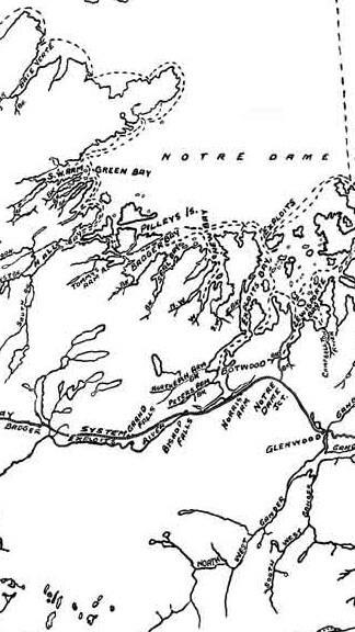
5 EXPLOITS RIVER Location On East Coast, empties into Exploits Bay of Notre Dame Bay. Season Good fishing can be had during July and August. General Remarks This is the largest river in Newfoundland, 200 miles in length. An excellent trip can be had, starting from the mouth of the river, to Red Indian Lake, a few portages being necessary, [which] can be followed to its head, passing on through Lloyd s Lake to King George Fourth Lake. From here a portage of about 5 miles lands one on Victoria Lake and then down Victoria River to Millertown, at the foot of Red Indian Lake. A total distance of approximately 275 miles. Good salmon fishing can be obtained as far as Grand Falls, and above splendid trout and Ouananiche fishing. River boats or canoes are essential for a good fishing trip on the river. Tributaries: Great Rattling Brook 2D/13 Green Woods Brook 2D/13 Sandy Brook 2D/13 Stony Brook 2D/13 Wigwam Brook 2D/13 Middle Brook 2D/13 Junction Brook 12A/16 Noel Paul s Brook 12A/16 Pamehac Brook 12A/16 Black Duck Brook 12A/16 Notes: Many more tributaries are not listed here. Enhancement has created salmon habitat above Grand Falls. Pools: Dam Pool, 12 unnamed pools
6

7 DOG BAY RIVER Location At the bottom of Dog Bay, Notre Dame Bay, on the East Coast. Season July and August are the best months. General Remarks Numerous pools are located on this river as far as Punt Pond and good camping sites are numerous. The river offers good canoeing to head of pond. A nice run of medium-weight (10 lbs.) salmon frequent this river. Notes: Unnamed on 2E/7 Pools: Rapid Pool, Island Pool, Third Pool, Outlet Pool, Narrows Pool, Inlet Pool, 2 Island Pool, Branch Pools, Burnt Brook Pools
8
 and sea-trout fishing. Notes: Now Indian Arm Brook. 2E/2 Pools: Tidal Pools, Dam Pools, Inlet Pool, Outlet Pool")
9 CAMPBELLTON RIVER Location In Lewisport Bay, Notre Dame Bay, on the East Coast. Season July and August. General Remarks This river is 10 miles out the Bay and can be reached by coastal boat S.S. Clyde in an hour, or by motor boat from Lewisport where boats can be hired. This river offers good salmon (medium-sized) and sea-trout fishing. Notes: Now Indian Arm Brook. 2E/2 Pools: Tidal Pools, Dam Pools, Inlet Pool, Outlet Pool
10
11 GANDER RIVER Location On the East Coast, flows into Gander Bay, Notre Dame Bay. Season From 15 th July till close of season 15 th September. General Remarks From Glenwood down the river to the sea, a distance of 25 miles, offers an excellent canoe and fishing trip. There are four narrow ponds or steadies on the Main River. The salmon pools are numerous and good camping sites readily found. Salmon Brook flows into the Main River near Glenwood. This brook also contains some good pools. River boats or canoes are essential. North West River and South West River flow into Gander Lake about 10 miles from Glenwood and during the latter part of the season offer excellent fishing. A large and heavy run of fish frequent this river. Any fish over 30 lbs. in weight have been caught. Tributaries: Bellman s Brook 2E/2 Weir s Brook 2E/2 Island Pond Brook 2E/2 Joe Batts Brook 2E/2 Millers Brook 2E/2 Jonathan s Brook 2E/1 Salmon River 2E/2 Notes: The Gander River rises in the Partridgeberry Hills refers to Northwest Gander River. It and Southwest Gander River are the main feeders of Gander Lake Pools: Forsey Rattle Pool, Long Rattle Pool, Big Shute Pool, Salmon Pool, Long Angle Island Pool, Falls on Salmon Brook Pool
12
 salmon and trout frequent this river.")
13 RAGGED HARBOUR BROOK Location In Ragged Harbour on the East Coast. Season July and August are the best months. General Remarks This river has some fine pools over a distance of about 8 miles to New Pond. A fine run of medium-weight (10 lbs.) salmon and trout frequent this river. Pools: Tidal Pools, Bulrush Pool, Falls Pools, Angle Pool, Branch Pool, Pond Pool
14

15 ANCHOR BROOK Location At the entrance to Sir Charles Hamilton Sound on the East Coast. Season July and August are the best months. General Remarks This is a wide flat brook with numerous pools on the main brook and its tributaries. It is connected by road to Ragged Harbour and Deadman s Bay. The bridge pools are noted as being good pools on this brook. The run of salmon is large, but fish over 10 lbs. are scarce. Notes: Part of the Anchor Brook-Deadman s Brook drainage system. Pools: Tidal Pool, Bridge Pools, Outlet Pool, First Pond Pools, First Feeder Pools, Falls Pool
16

17 DEADMAN S BAY BROOK Location In Deadman s Bay on the East Coast. Season July and August are good months. General Remarks From the sea to Deadman s Pond there are some fine pools, those in the first 2 miles being noted for their good fishing. A fine run of medium fish frequent this brook. Notes: Now Deadman s Brook. Part of the Anchor Brook-Deadman s Brook drainage system. Pools: Tidal Pool, Second Pool, Third Pool, Fourth Pool, Feeder Pool, Outlet Pool
18
 and sea trout frequent this river.")
19 INDIAN BAY BROOK Location At the bottom of Indian Bay, Bonavista Bay, on the East Coast. Season July and August are the best months. General Remarks A nice river and the pools are readily accessible by canoe. A large run of medium-weight salmon (10 lbs.) and sea trout frequent this river. Pools: Tidal Pool, Second Pool, Outlet Pools, Falls Pools, Upper Pools
20

21 MIDDLE BROOK Location In Freshwater Bay, Bonavista Bay, on the East Coast. Season July and August are the best months. General Remarks This river contains some fine salmon pools which are accessible by trails. A heavy run of medium salmon and sea trout frequent the river, and being only 4 miles from Gambo can be fished daily out of there. Pools: Tidal Pools, Butts Pond Pool, Bridge Pool, Steady Pool, Square Pond Pools, Inlet Pool, Outlet Pool
22
23 GAMBO RIVER Location In the bottom of Freshwater Bay, Bonavista Bay, on the East Coast. Season July and August are good months. General Remarks This is a fine large river and fishing can be undertaken with ease as all the pools can be reached by boat from Gambo. A large and heavy run of salmon frequent this river. There is also good sea-trout fishing. Salmon up to 30 lbs. in weight have been caught. Boats or canoes are essential. Gambo being at the river s mouth, and the lower pools being accessible by boat, the angler can stay at Gambo and fish the river daily. Tributaries: Mint Brook Notes: Now Gambo Brook. Flows from Gambo Pond to the sea. 2D/9 Pools: Mosse's Pool, Black Pool, Birchy Shute Pool, Rocky Pool, Middle Shute Pool, Dam Pool, Mint Brook Pool, The Narrows Pool, Triton Brook Pool, Whiteway's Pool, Rocky Brook Pool, Riverhead Pool
24

25 TERRA NOVA RIVER Location On the East Coast, this river flows into the middle arm of Alexander Bay, Bonavista Bay. Season July and August are the best months. General Remarks This is one of the large rivers of the Island and good fishing can be had from its mouth to the falls, a distance of 7 miles. Sea trout can also be caught. Camping sites are numerous. The run of salmon is large, fish up to 30 lbs. in weight having been caught Tributaries: Maccles Brook 2D/9 Pools: Dr. Smith's Pool, Marine's Pool, Winter's Pool, 8 unnamed pools
26

27 NORTH WEST, SOUTH WEST AND SALMON RIVERS, PORT BLANDFORD Location These three rivers are located at the bottom of Clode Sound, Bonavista Bay. Season July and August are good months. General Remarks A sportsman fishing here has 3 rivers, all readily accessible from the railway. Each river offers good salmon and sea-trout fishing over a distance of approximately 5 miles from their respective mouths and can be fished daily from Port Blandford. A fine run of medium-sized (10 lbs.) salmon frequent these rivers. Notes: Now Salmon Brook Pools: North West River Tidal Pool, Bridge Pools, Fourth Pool, Fifth Pool Pools: South West River Steady Pools, Third Pool, Brook Pool
28
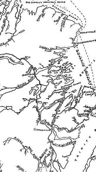
29 23 other rivers and brooks STRAIGHT AND WINDMILL BROOKS [2F/5-2F/6] On what is known as the Straight Shore, at the entrance to Sir Charles Hamilton Sound. Good for medium-sized salmon and sea trout. TRAVERSE BROOK [2D/16] About 10 miles from the bottom of Freshwater Bay, Bonavista Bay. A good brook for salmon and sea trout. NORTH WEST BROOK [2D/9] At the bottom of North West Arm of Alexander Bay, Bonavista Bay. An excellent brook for sea trout. NEWMAN S SOUND RIVER [Saltons Brook, Big Brook, and Minchin Brook all flow into Newman Sound; 2C/12] At the bottom of Newman s Sound, Bonavista Bay. A good river for salmon and sea trout and nice for travelling and fishing. GOOSE BAY BROOK [Now Southwest Brook; 2C/5] At the bottom of Goose Bay, Clode Sound, Bonavista Bay. Good for grilse and sea trout. SOUTHWARD BAY BROOK [Now Southern Bay Brook; 2C/5] At the bottom of Southward Bay, Bonavista Bay. Good for small salmon and sea trout. NORTH WEST, SOUTH WEST, AND SALMON RIVERS [Now Rattling Brook flows into Northwest Arm and Salmon Cove River; 2C/6] On the northwest side of Trinity Bay. The North West River is readily accessible from Port Rexton, the South West River from Trinity, and Salmon River from English Harbour, all stations on the Bonavista Branch of the Newfoundland Railway. They are all good rivers for fishing, Big Pond, Big Rattle and Trepassey Steadies, 3 pools on Salmon River, being well known for their fishing. TROUTY BROOK [2C/6] At Trouty on west side of Trinity Bay. An excellent brook for sea trout. The settlement is at the mouth of the brook. POPE S HARBOUR, RIDER S AND SHOAL HARBOUR RIVERS [2C/4] In Smith Sound, Trinity Bay. All good brooks for sea trout.
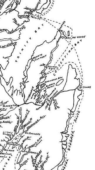
![NORTH WEST BROOK [Now Southwest Arm Brook; flows into Deer Harbour; 1N/13] Bottom of South West Arm, Trinity Bay. Good for salmon and sea trout and contains some splendid fishing pools.](/docs-images/79/79733335/images/30-0.jpg "SALMON COVE RIVER [Now Salmon River; 1N/14] At the bottom of Salmon Cove, Conception Bay. A good river for salmon and trout, with many pools and ponds.")
30 NORTH WEST BROOK [Now Southwest Arm Brook; flows into Deer Harbour; 1N/13] Bottom of South West Arm, Trinity Bay. Good for salmon and sea trout and contains some splendid fishing pools. SALMON COVE RIVER [Now Salmon River; 1N/14] At the bottom of Salmon Cove, Conception Bay. A good river for salmon and trout, with many pools and ponds. SEARSTOWN BROOK [Now Shearstown Brook; 1N/11] At the bottom of Spaniard s Bay, Conception Bay. Good for grilse and sea trout. Settlement on the brook. NORTH AND SOUTH RIVERS, CLARKE S BEACH [1N/11] At the bottom of Port de Grave, Conception Bay. Good for small salmon and sea trout. GOULD S BROOK, AVONDALE BROOK, NORTH AND SOUTH BROOK HOLYROOD AND SEAL COVE BROOK [1N/6] All at the bottom of Conception Bay. All good sea-trout brooks with a few salmon.
31
32
33
ATLANTIC SALMON NEWFOUNDLAND AND LABRADOR, SALMON FISHING AREAS 1-14B. The Fisheries. Newfoundland Region Stock Status Report D2-01
 Fisheries Pêches and Oceans et Océans DFO Science Newfoundland Region Stock Status Report D2-01 ATLANTIC SALMON NEWFOUNDLAND AND LABRADOR, SALMON FISHING AREAS 1-14B Background There are 15 Atlantic salmon
Newfoundland and Labrador Assessment of Atlantic Salmon on Monitored Rivers in 2017
 Newfoundland and Labrador Assessment of Atlantic Salmon on Monitored Rivers in 217 % Conservation Achieved Science advice & the precautionary approach The precautionary approach is a management framework
TIPS (8477)
") Fisheries and Oceans Canada Pêches et Océans Canada Newfoundland and Labrador ANGLER S GUIDE 2016-2017 www.nfl.dfo-mpo.gc.ca Help us conserve and protect our fish stocks. Report poaching activity to Crime
Fisheries and Oceans Canada Pêches et Océans Canada Newfoundland and Labrador ANGLER S GUIDE 2016-2017 www.nfl.dfo-mpo.gc.ca Help us conserve and protect our fish stocks. Report poaching activity to Crime
TIPS (8477)
") Fisheries and Oceans Canada Pêches et Océans Canada Newfoundland and Labrador ANGLER S GUIDE 2012 2013 www.nfl.dfo-mpo.gc.ca Help us conserve and protect our fish stocks. Report poaching activity to Crime
Fisheries and Oceans Canada Pêches et Océans Canada Newfoundland and Labrador ANGLER S GUIDE 2012 2013 www.nfl.dfo-mpo.gc.ca Help us conserve and protect our fish stocks. Report poaching activity to Crime
TIPS (8477)
") Fisheries and Oceans Canada Pêches et Océans Canada Newfoundland and Labrador ANGLER S GUIDE 2014-2015 www.nfl.dfo-mpo.gc.ca Help us conserve and protect our fish stocks. Report poaching activity to Crime
Fisheries and Oceans Canada Pêches et Océans Canada Newfoundland and Labrador ANGLER S GUIDE 2014-2015 www.nfl.dfo-mpo.gc.ca Help us conserve and protect our fish stocks. Report poaching activity to Crime
Highland Region MAP. No. 11 St. Marys River No. 12 West River No. 13 Wallace River No. 14 Toney River No. 15 Northumberland Strait
 Highland Region MAP No. 11 St. Marys River No. 12 West River No. 13 Wallace River No. 14 Toney River No. 15 Northumberland Strait 14 Route: No. 11 St. Marys River Rating: Intermediate Advanced Length:
Newfoundland & Labrador Atlantic Salmon 2002 Stock Status Update
 Fisheries and Oceans Canada Pêches et Océans Canada Newfoundland and Labrador Region Stock Status Update D2-1 (22) Newfoundland & Labrador Atlantic Salmon 22 Stock Status Update Background There are 15
Proposed Electoral Districts
 Proposed Electoral Districts Page Baie Verte Green Bay... 54 Bonavista... 56 Burgeo La Poile... 58 Burin Grand Bank... 60 Cape St. Francis... 62 Cartwright L Anse au Clair... 64 Conception Bay South...
Newfoundland & Labrador Atlantic Salmon 2004 Stock Status Update
 Stock Status Report 24/4 Newfoundland & Labrador Atlantic Salmon 24 Stock Status Update Background There are 15 Atlantic salmon (Salmo salar) management areas, known as Salmon Fishing Areas (SFAs) 1-14B,
Launch A: Experimental Lakes Road The launch site is about 4 km from highway #17. There is a sign on the highway indicating the experimental lakes
 Launch A: Experimental Lakes Road The launch site is about 4 km from highway #17. There is a sign on the highway indicating the experimental lakes road. You have to cross railway tracks on the way to the
Atlantic Pilotage Authority
 Atlantic Pilotage Authority Presentation to Whites Point Rock Quarry Project, Digby, NS. Digby, N.S. June 20, 2007 Captain Patrick Gates Director of Operations Atlantic Pilotage Authority Mandate To establish,
Newfoundland & Labrador Atlantic Salmon Stock Status
 1998 Newfoundland & Labrador Atlantic Salmon Stock Status Background There are more than 200 rivers in Newfoundland and Labrador with anadromous Atlantic salmon populations. Each river is assumed to consist
Canoe Trip # Maps: 63L Amisk Lake 63M Pelican Narrows
 Canoe Trip #51 49 Southeast Arem Deschambault Lake - Pelican Narrows - Wunehikun Bay - Attitti Lake - Belcher Lake - Mukoman Lake - Ohoo Lake - Mukoman River - Sokatisewin Lake - Sandy Bay 170 Kilometers
Canoe Trip # Length of Trip: 225 kilometres Time Required to Complete Trip: 10 to 14 days Number of Portages: 21 to 25
 Canoe Trip #34 34 Brabant Lake - Wapiskau River - Steephill Lake - Reindeer River - Churchill River - Sandy Bay 225 Kilometers - 10 to 14 days - 21 to 25 portages Length of Trip: 225 kilometres Time Required
ESTIMATED RETURNS AND HARVEST OF COLUMBIA RIVER FALL CHINOOK 2000 TO BY JOHN McKERN FISH PASSAGE SOLUTIONS
 ESTIMATED RETURNS AND HARVEST OF COLUMBIA RIVER FALL CHINOOK 2000 TO 2007 BY JOHN McKERN FISH PASSAGE SOLUTIONS ESTIMATED RETURNS AND HARVEST OF COLUMBIA RIVER FALL CHINOOK 2000 TO 2007 This analysis of
Striped Bass and White Hybrid (x) Striped Bass Management and Fishing in Pennsylvania
 Striped Bass Management and Fishing in Pennsylvania") Striped Bass and White Hybrid (x) Striped Bass Management and Fishing in Pennsylvania Prepared by R. Lorantas, D. Kristine and C. Hobbs PFBC Warmwater Unit 2005 (stocking numbers updated after 2005) Goal:
Striped Bass and White Hybrid (x) Striped Bass Management and Fishing in Pennsylvania Prepared by R. Lorantas, D. Kristine and C. Hobbs PFBC Warmwater Unit 2005 (stocking numbers updated after 2005) Goal:
THE Kapisilik River. by Keld Jensen. Quit. Kapisillit The Kapisilik River. Thumbnails
 KAPISILLIT THE Kapisilik River by Keld Jensen Thumbnails 9 3 4 Behind Kapisillit - south of the settlement - a long valley forms the course of the river Kapisillik. Kapisillik runs through seven large
Fisheries & Aquaculture
 Fisheries & Aquaculture Licence # Species Licencee Location Size (Ha) Latitude Longitude Last Updated: November 9, 2015 4 BM, GS, O Mills, Terry Charles Arm 69 49.3483-55.2787 ST - Steelhead Trout 15 BM
SECTION II NM 11/13 NAVIGATION PUBLICATIONS COAST PILOT CORRECTIONS. Chapter 4 Paragraphs 85 to 86; read: (85)
") NAVIGATION PUBLICATIONS COAST PILOT CORRECTIONS COAST PILOT 1 42 Ed 2012 Change No. 13 LAST NM 9/13 Chapter 4 Paragraph 9; read: (9) Round Rock, which uncovers, and The Boring Stone, 3 feet high and bare,
NAVIGATION PUBLICATIONS COAST PILOT CORRECTIONS COAST PILOT 1 42 Ed 2012 Change No. 13 LAST NM 9/13 Chapter 4 Paragraph 9; read: (9) Round Rock, which uncovers, and The Boring Stone, 3 feet high and bare,
Shoal Bay East Thurlow Island
 Shoal Bay East Thurlow Island Jason Zroback jason@landquest.com 1 (604) 414-5577 Jamie Zroback jamie@landquest.com 1 (604) 483-1605 The Source for Oceanfront, Lakefront, Islands, Ranches, Resorts & Land
Detailed maps, and portaging and camping information follow.
 Overview of Bain route. The launch site is at Davidson Lake, just before the Manitoba/Ontario border. You can do a loop if you leave a vehicle at Tulabi Lake (at the canoe route parking lot). The road
Salmon and Migratol~Y Trout of the N,anaimo 'River lind Adjacent Streams (Revised 1,973)
") .. '.' ~! ~j-:-t. ~" I. This s~rie~ includes " unpublished preliminary' reports. ana Glatd rec
.. '.' ~! ~j-:-t. ~" I. This s~rie~ includes " unpublished preliminary' reports. ana Glatd rec
The History of Commercial Fishing in Prince Edward Island
 The Open Suitcase Series Program Description The History of Commercial Fishing in Prince Edward Island This program explores the history of the second largest industry on Prince Edward Island and its origins,
Summer Visitors Play in Martha's Vineyard and Nantucket
 Summer Visitors Play in Martha's Vineyard and Nantucket Welcome to This Is America with VOA Learning English. This week on our program, we tell you about two islands in Massachusetts, in the New England
ATLANTIC SALMON (Salmo salar) STOCK STATUS UPDATE IN NEWFOUNDLAND AND LABRADOR FOR 2014
 STOCK STATUS UPDATE IN NEWFOUNDLAND AND LABRADOR FOR 2014") Canadian Science Advisory Secretariat Science Response 215/23 ATLANTIC SALMON (Salmo salar) STOCK STATUS UPDATE IN NEWFOUNDLAND AND LABRADOR FOR Context The stock assessment of Atlantic ( salar) in the
Canadian Science Advisory Secretariat Science Response 215/23 ATLANTIC SALMON (Salmo salar) STOCK STATUS UPDATE IN NEWFOUNDLAND AND LABRADOR FOR Context The stock assessment of Atlantic ( salar) in the
COUNTRIES THAT CONTRAVENED SCIENTIFIC ADVICE BY HARVESTING MIXED POPULATIONS OF NORTH AMERICAN SALMON IN 2017
 SCIENTIFIC ADVICE The International Council for the Exploration of the Sea (ICES) advises: There is no surplus of multi-sea-winter salmon for a fishery at West Greenland for 2018, 2019, and 2020. ICES
NEWFOUNDLAND AND LABRADOR COAST List of Lights, Buoys and Fog Signals. Focal Height in m. above water. Nominal. Range TRINITY BAY
 NEWFOUNDLAND AND LABRADOR COAST List of s, Buoys and 450.1 Shag Rock light buoy TM1 Melrose Harbour. 48 28 26.3 053 03 32.8 Fl G 4s...... Green spar, marked TM1. Edn 10/11 (N11-061) 450.2 Bill s Shoal
DRIVING TOURS. Grays Harbor County is a fisherman s dream! Fish the bay, ocean, streams, rivers or lakes... the choice is yours!
 Grays County is a fisherman s dream! bay, ocean, streams, rivers or lakes... the choice is yours! Grays offers excellent fresh and saltwater fishing in all seasons. Fish in the open ocean for tuna, halibut,
Removal of natural obstructions to improve Atlantic Salmon and Brook Trout habitat in western NL. 26/02/2015 Version 2.0
 Removal of natural obstructions to improve Atlantic Salmon and Brook Trout habitat in western NL 26/02/2015 Version 2.0 1 Table of Contents List of Tables... 2 Introduction... 3 Methods... 4 Preliminary
Canoe Route. Dogtooth Lake-Highwind Lake-Dryberry Lake- Lake of the Woods-Blindfold Lake
 1 Canoe Route Dogtooth Lake-Highwind Lake-Dryberry Lake- Lake of the Woods-Blindfold Lake This is an interesting and challenging route starting and ending at Rushing River Provincial Park. It passes over
! " # $ % & % & ' ( ) * +
 * +") !" #$%& %& '() *+ EnVision Manistee County Fact Book Manistee County Community Foundation Spring 2005 Natural Environment & Recreation Page 1 Commercial Lodging Many of Manistee County s visitors choose
!" #$%& %& '() *+ EnVision Manistee County Fact Book Manistee County Community Foundation Spring 2005 Natural Environment & Recreation Page 1 Commercial Lodging Many of Manistee County s visitors choose
COUNTRIES THAT CONTRAVENE SCIENTIFIC ADVICE BY HARVESTING MIXED-POPULATIONS OF NORTH AMERICAN SALMON
 SCIENTIFIC ADVICE A Backgrounder from Atlantic Salmon Federation P. O. Box 5200, St. Andrews, NB E5B 3S8 P. O. Box 807, Calais, ME USA 04619 0807 Tel: (506) 529 4581 www.asf.ca State of North American
Tidal energy is produced by the surge of ocean waters during the rise and fall of tides. Tidal energy is a renewable source of energy.
 Encyclopedic Entry For Educator tidal energy For the complete encyclopedic entry with media resources, visit: http://www.connectenergyed.org/education/encyclopedia/tidal-energy/ Tidal energy is produced
13. TIDES Tidal waters
 Water levels vary in tidal and non-tidal waters: sailors should be aware that the depths shown on the charts do not always represent the actual amount of water under the boat. 13.1 Tidal waters In tidal
The Fishery. Newfoundland Region Stock Status Report D2-05
 Fisheries Pêches and Oceans et Océans DFO Science Newfoundland Region Stock Status Report D2-05 ATLANTIC SALMON INSULAR NEWFOUNDLAND, SOUTHWEST COAST, SALMON FISHING AREAS 12-13 Background Salmon Fishing
Designated Trout Stream Additions Arrowhead Creek
 Designated Trout Stream Additions Arrowhead Creek A small reach of Arrowhead Creek was inadvertently left off the list of sections when the stream was originally designated. This designation would fill
Macutagon Creek to Russell s Landing
 Day Trips Macutagon Creek to Russell s Landing Manitouwadge Public Consultation Committee Canoe Route #13 #13 MACUTAGON CREEK TO RUSSELL S LANDING This route is suitable to all levels of paddlers but due
62. Gulkana River, Main Fork, Middle Fork, and West Fork
 62. Gulkana River, Main Fork, Middle Fork, and West Fork The Gulkana, a National Wild and Scenic River, is one of Alaska s most popular whitewater rivers because of its road accessibility and because of
Map Showing NAFO Management Units
 Map Showing NAFO Management Units Biology Are 6 species of seals in Atlantic Canadian waters, all of which occur in Newfoundland Two Arctic Species (Ringed, Bearded) Two temperate (Grey, Harbour) Two migratory
Geography of the Lower Fitzroy and navigation problems
 Geography of the Lower Fitzroy and navigation problems A topographic map of the Fitzroy estuary readily indicates why the Fitzroy River has proved difficult for shipping to negotiate. The river meanders
Breakwater Wharf Encasement Hant s Harbour, Newfoundland
 ABSTRACT Breakwater Wharf Encasement Hant s Harbour, Newfoundland Jamie Downey Memorial University of Newfoundland St. John's, NL, Canada jdowney@mun.ca Hant s Harbour, a small fishing community located
Bay of Fundy Estuary Profile
 s The is a sub-basin of the Bay of Fundy along the northwestern shore of Nova Scotia and at the western end of the Annapolis Valley. The Annapolis River is the major water source flowing into the estuary.
A guide to fisheries regulations ENVIRONMENT CORNWALL SEA FISHERIES COMMITTEE. WaW AGENCY
 A guide to fisheries regulations CORNWALL SEA FISHERIES COMMITTEE ENVIRONMENT WaW AGENCY The Fal Estuary and Coastal Area BASS FACTS Bass grow and mature slowly and may not breed until they are 7 years
The Canoe Trip: Optional Portage Number 1 - Nut Portage: Optional Portage Number 2 - English Bay Portage:
 Canoe Trip #9 9 La Ronge - Iskwatikan Lake - Churchill River - Pelican Narrows - Mirond Lake - Sturgeon-Weir River - Maligne Lake (Kilometre 275 Hanson Lake Road) 245 to 270 Kilometers - 7 to 10 days -
Warm-up # 7 A day 5/17 - B day 5/18 UPDATE YOUR TABLE OF CONTENTS
 Warm-up # 7 A day 5/17 - B day 5/18 UPDATE YOUR TABLE OF CONTENTS Question: List all examples of surface water on Earth. Answer: Rivers and streams, lakes and reservoirs, (ponds) wetlands, estuaries and
lot across from the Barrington Post Office, please do not use Woolen Mill Museum parking if there are more than 1 vehicle.
 BARRINGTON Launch Rating Moderate to difficult depending on your skills. Launch Description This launch is usable at high tide using proper skills to enter and exit your kayak. Put in just above the concrete
STOCK ASSESSMENT OF NEWFOUNDLAND AND LABRADOR ATLANTIC SALMON 2016
 Canadian Science Advisory Secretariat Newfoundland and Labrador Region Science Advisory Report 2017/035 STOCK ASSESSMENT OF NEWFOUNDLAND AND LABRADOR ATLANTIC SALMON 2016 Image: Atlantic Salmon (Salmo
Monitoring for invasive tunicates in Nova Scotia, Canada ( )
") Aquatic Invasions (2011) Volume 6, Issue 4: 391 403 doi: 10.3391/ai.2011.6.4.04 2011 The Author(s). Journal compilation 2011 REABIC Open Access Proceedings of the 3rd International Invasive Sea Squirt
Aquatic Invasions (2011) Volume 6, Issue 4: 391 403 doi: 10.3391/ai.2011.6.4.04 2011 The Author(s). Journal compilation 2011 REABIC Open Access Proceedings of the 3rd International Invasive Sea Squirt
Georgia s Rivers. Ms. Masters 2 nd Grade Stoneview Elementary
 Georgia s Rivers Ms. Masters 2 nd Grade Stoneview Elementary Georgia s 7 Main Rivers Altamaha River Chattahooche River Flint River Ocmulgee River Oconee River Savannah River St. Mary s River Can you spot
Brook Trout Angling in Maine2009 Survey Results
 Maine State Library Maine State Documents Resource Management Documents Inland Fisheries and Wildlife 5-3-2010 Brook Trout Angling in Maine2009 Survey Results Marc Edwards University of Maine Cooperative
SELF GUIDED TOURING ROUTE
 SELF GUIDED TOURING ROUTE Things to see and places to go on the loop from Orbost to Marlo, Cape Conran, Cabbage Tree and back to Orbost (or onwards to Cann River) V6 April 2017 This guide should be read
Montessori for Everyone 2013 Types of Coastlines
 Coast The coast is the part of the land that borders the sea. It is subject to constant change, as the result of the waves and deposits carried by water onto the land. Coastline The coastline is where
Pirate s Haven. Adventures & chalets. January Pirate s Haven 1
 Pirate s Haven Adventures & chalets January 2011 - Pirate s Haven 1 Pirate s Haven Adventures & chalets layout by Hans van Klinken photographs by Hans and Ina van Klinken We offer three four star chalets
Adventure Quest Outfitters is committed to providing outstanding Newfoundland guided hunts, success rates, services, and accommodations.
 Guided Hunting Adventures in the Pristine Wilds of Western Newfoundland, Canada WELCOME TO THE ADVENTURE OF A LIFETIME ABOUT ADVENTURE Adventure Quest Outfitters share your passion for big game hunting
Vocabulary: Headwaters, watershed, tributaries, estuary, replica, point source pollution, nonpoint source pollution, amd river miles.
 From Source To Sea: Lesson Plan Concepts: 1. Understanding the path the Hudson River takes from the headwaters in the Adirondacks to the New York Harbor 2. Identifying the Hudson River watershed area,
SHIPS, SHIPPING AND FISHING
 Cambridge Industriai and Commercial Series General Editor : G. F. BOSWORTH, F.R.G.S. SHIPS, SHIPPING AND FISHING SHIPS, SHIPPING AND FISHING WITH SOME ACCOUNT OF OUR SEAPORTS AND THEIR INDUSTRIES by GEORGE
TICES TO MARINERS 1 TO 46 ANNUAL EDITION 2018 SECTION A AIDS TO NAVIGATION AND MARINE SAFETY
 A5 NAVIGATION SAFETY 10 Routeing of Ships 1 GENERAL 1.1 Rule 10 of the Collision Regulations applies to all ships navigating in or near a routeing system. 1.2 The information on ships' routeing in this
What was the historic coaster fishery like?
 1 of 6 1/30/2012 12:25 PM Home About Topics Contact Us Fishing Calendar Fish ID Tips FAQs Hack Noyes Research Vessel Is it a unique strain long lost from Wisconsin's shoreline? Fisheries Reports Tributaries
The Rare American Atlas
 The Rare American Atlas JEFFERYS, Thomas. The American Atlas: or, A Geographical Description of the Whole Continent of America. Wherein Are Delineated at Large, Its Several Regions, Countries, States,
Orange County MPA Watch Program Quarterly Report (Jan 1 March 31, 2012)
") Orange County MPA Watch Program Quarterly Report (Jan 1 March 31, 2012) What is the OC MPA Watch Program? The Orange County Marine Protected Area (OC MPA) Watch Program enlists volunteers, community groups
Orange County MPA Watch Program Quarterly Report (Jan 1 March 31, 2012) What is the OC MPA Watch Program? The Orange County Marine Protected Area (OC MPA) Watch Program enlists volunteers, community groups
Welcome to Scotland's Marine Tourism and Recreation Survey
 Welcome to Scotland's Marine Tourism and Recreation Survey The way Scotland's seas and coasts are managed is changing. Marine Scotland, the Scottish Government body with responsibility for managing Scotland's
NEVADA DIVISION OF WILDLIFE STATEWIDE FISHERIES MANAGEMENT FEDERAL AID JOB PROGRESS REPORTS F YELLOWSTONE CUTTHROAT TROUT EASTERN REGION
 NEVADA DIVISION OF WILDLIFE STATEWIDE FISHERIES MANAGEMENT FEDERAL AID JOB PROGRESS REPORTS F-20-48 2012 YELLOWSTONE CUTTHROAT TROUT EASTERN REGION NEVADA DEPARTMENT OF WILDLIFE, FISHERIES DIVISION ANNUAL
6TH PELLETIER BROOK LAKE T15 R9, Aroostook Co. U.S.G.S. Gardner Pond, Maine (7 1/2 )
") 6TH PELLETIER BROOK LAKE T15 R9, Aroostook Co. U.S.G.S. Gardner Pond, Maine (7 1/2 ) Fishes Brook trout Minnows Blacknose dace Pearl dace Physical Characteristics Area - 27 acres Average depth - 2 feet
6TH PELLETIER BROOK LAKE T15 R9, Aroostook Co. U.S.G.S. Gardner Pond, Maine (7 1/2 ) Fishes Brook trout Minnows Blacknose dace Pearl dace Physical Characteristics Area - 27 acres Average depth - 2 feet
Orange County MARINE PROTECTED AREAS
 Orange County MARINE PROTECTED AREAS Orange County Coastkeeper QUARTERLY REPORT 1/1/ 2013 3/30/12 2013 WHAT IS THE OC MPA WATCH PROGRAM? The Orange County Marine Protected Area (OC MPA) Watch Program enlists
Sections of the Marine Mammals Regulations Specific to Narwhal, Beluga, and Walrus
 Sections of the Marine Mammals Regulations Specific to Narwhal, Beluga, and Walrus 4. (1) Subject to subsections (2) and 32(1), the Minister may, on application and payment of the fee set out in column
2 History & Geography. 2.1 Geography The Delmarva Peninsula
 2 History & Geography 2.1 Geography 2.1.1 The Delmarva Peninsula The Delmarva Peninsula is a large peninsula on the east coast that contains land within the three states of Delaware, Maryland, and Virginia.
Chapter I: Marine Resources
 NOTE TO READERS: This is a draft of the Kennebunk Comprehensive Plan. The Comprehensive Plan provides us with a description of the town today in a range of categories, and identifies issues and recommendations
TRAPLINE VC34 Land Use Before the La Grande Complex
 SUMMARY OF TRAPLINE LAND USE BEFORE THE LA GRANDE PROJECT TRAPLINE VC34 Land Use Before the La Grande Complex Trapline Background Information The trapline VC34 is located at more than 175 km east of Eastmain,
Kayak Launch Sites in the Bellingham Area
 revised: Feb. 5, 2017 Page 1 of 5 Arranged Roughly North to South NOTE: if you want to see location on a map just cut and paste the Latitude and Longitude into your browser and a map with the location
The Economic Importance of Recreational River Use to the City of Calgary
 The Economic Importance of Recreational River Use to the City of Calgary Prepared by: Calgary River Users Alliance May 20, 2016 The Economic Importance of Recreational River Use to the City of Calgary
Draw a picture of a water source. Don t forget to include yourself in the picture!
 Name Date Draw a picture of a water source. Don t forget to include yourself in the picture! My water source is Students describe the characteristics of a water source: stream, river, lake, pond, ocean,
VIEWS IN "ENGLAND'S OLDEST COLONY"
 11 VIEWS IN NEWFOUNDLAND "ENGLAND'S OLDEST COLONY" Showing some of its magnificent rivers, teeming with trout and salmon, its Barrens, alive with caribou, grouse, snipe, wild duck, etc., etc., charming
Summer Steelhead Surveys North Fork Trinity River Trinity County, California
 KRIS edition Summer Steelhead Surveys North Fork Trinity River Trinity County, California 1978-1997 By Loren Everest Fishery Biologist Weaverville Ranger District Shasta-Trinity National Forests October
DOWNLOAD OR READ : THE TROUT FISHERMEN PDF EBOOK EPUB MOBI
 DOWNLOAD OR READ : THE TROUT FISHERMEN PDF EBOOK EPUB MOBI Page 1 Page 2 the trout fishermen the trout fishermen pdf the trout fishermen Trout is the common name for a number of species of freshwater fish
NOT FOR REPRODUCTION. Underwater Technology Used to Bring Closure to Families of Drowning Victims. by Gene Ralston and Junior Pinksen
 Underwater Technology Used to Bring Closure to Families of Drowning Victims by Gene Ralston and Junior Pinksen (L-R): Junior Pinksen, Sandy Ralston, Gene Ralston. Editor s note: Gene and Sandy Ralston
October 29, 2017 File: 677
 Gabriola Streamkeepers (GSK) Stream surveys These are summaries only, not master copies, of Gabriola Streamkeeper field reports and surveys. Surveys are categorized here as following types: B F M Q T W
Mamele awt Aboriginal Education Centre
 The Four Ladies (2,3) Lesson Plan - 1 Hour Materials Needed: The 4 Ladies Kit Introduction: 1. Introduce Yourself Introduce yourself (name, title, where you are from, who you are as an Aboriginal Person)
2010 Kemp Lake Angling and Lake Infrastructure Improvement Proposal
 2010 Kemp Lake Angling and Lake Infrastructure Improvement Proposal Prepared for: Capital Regional District Juan de Fuca Electoral Area Community Parks and Recreation #2-6868 West Coast Road P.O. Box 283,
RECREATION. in the St. Paul District. Your safety is our concern ALWAYS wear a LIFE VEST
 RECREATION in the St. Paul District Your safety is our concern ALWAYS wear a LIFE VEST Cross La RECREATION in the St. Paul District CANADA NORTH DAKOTA Lake of the Woods Homme Lake Devils Lake Red River
KOOCANUSA KOKANEE ENUMERATION (2003) Prepared by: W. T. Westover Fisheries Biologist
 Prepared by: W. T. Westover Fisheries Biologist") KOOCANUSA KOKANEE ENUMERATION (2003) Prepared by: W. T. Westover Fisheries Biologist Ministry of Water, Land and Air Protection 205 Industrial Road G, Cranbrook, B. C. V1C 7G5 December, 2003 INTRODUCTION
KOOCANUSA KOKANEE ENUMERATION (2003) Prepared by: W. T. Westover Fisheries Biologist Ministry of Water, Land and Air Protection 205 Industrial Road G, Cranbrook, B. C. V1C 7G5 December, 2003 INTRODUCTION
4 th Quarter 2014 Report OC MPA Watch Program Orange County Coastkeeper
 4 th Quarter 2014 Report OC MPA Watch Program Orange County Coastkeeper Intro January 1 st, 2012 was the implementation date for the South Coast MPAs from Point Conception to the Mexican border. The Orange
DOWNLOAD OR READ : TROUT FISHING FOR THE BEGINNER PDF EBOOK EPUB MOBI
 DOWNLOAD OR READ : TROUT FISHING FOR THE BEGINNER PDF EBOOK EPUB MOBI Page 1 Page 2 trout fishing for the beginner trout fishing for the pdf trout fishing for the beginner Fishing the warmest part of the
For more information or permission to reprint slides, please contact Donna Milligan at 1
 For more information or permission to reprint slides, please contact Donna Milligan at milligan@vims.edu 1 For more information or permission to reprint slides, please contact Donna Milligan at milligan@vims.edu
Orange County MARINE PROTECTED AREAS 2 nd Quarter 2016 Report
 Orange County MARINE PROTECTED AREAS 2 nd Quarter 2016 Report Page 1 of 7 WHAT IS THE OC MPA WATCH PROGRAM? The Orange County Marine Protected Area (OC MPA) Watch Program enlists volunteers, community
Goulding/Goulden: From Wimborne to Greenspond. Presentation by Bill Goulding to Wessex Society of Newfoundland January 12, 2011
 Goulding/Goulden: From Wimborne to Greenspond Presentation by Bill Goulding to Wessex Society of Newfoundland January 12, 2011 Wimborne Minister... Grand Falls - Windsor Greenspond Man Point Cove
Narrows West. Lots For Sale Overview
 Lots For Sale Overview Spring/Summer Sales Book 2017 My family has been living at the Lake Manitoba Narrows for approximately 100 years. One of my grandfathers settled on the west shore of the Narrows
Creating land trusts require compromise. Birds I View
 Northeast Avalon Times February 2016 Northeast Avalon Times February 2016 Creating land trusts require compromise Birds I View The productive dogberry crops are attracting a variety of late winter birds
Developing Back Bay. Pre-Handout. Scope and Background
 Developing Back Bay Pre-Handout Scope and Background This is your third project and substantially different from the first two. It is actually a large scale planning project and as such, it is open ended.
An Example of Adaptive Ship Construction: Examining the Vinta in Its Geographic Context
 Jacob Bradt Anthro1218 Museum Project: Pt. III An Example of Adaptive Ship Construction: Examining the Vinta in Its Geographic Context To analyze the construction of the Peabody Museum s model of a vinta,
Quay County, New Mexico 160 deeded acres; (MOL) $420,000
 $420,000") Quay County, New Mexico 160 deeded acres; (MOL) $420,000 Turn your steers out and watch them gain! FARMING House Ranch offers 60 acres of water rights This region of New Mexico just east of Tucumcaro
Quay County, New Mexico 160 deeded acres; (MOL) $420,000 Turn your steers out and watch them gain! FARMING House Ranch offers 60 acres of water rights This region of New Mexico just east of Tucumcaro
Upstreampaddle 25.South arm of the Brunswick River, Simpson s Creek drains the freshwater swamp lands of Tyagarah Nature Reserve, 750 hectares. Furthe
 Upstreampaddle 24 The Brunswick River is a shorter length river on the coastal plain of Northern New South Wales. The areas of interest to canoeists are: the reach from the town of Mullumbimby down to
Bicycle Newfoundland and Labrador Annual Report from President - Kevin Flynn April 1, March 31, 2018
 Bicycle Newfoundland and Labrador Annual Report from President - Kevin Flynn April 1, 2017 - March 31, 2018 MEMBERSHIP I would like to acknowledge Bicycle Newfoundland and Labrador (BNL) members for having
Your web browser (Safari 7) is out of date. For more security, comfort and the best experience on this site: Update your browser Ignore
 is out of date. For more security, comfort and the best experience on this site: Update your browser Ignore") Your web browser (Safari 7) is out of date. For more security, comfort and the best experience on this site: Update your browser Ignore TIDAL ENERGY For the complete encyclopedic entry with media resources,
Your web browser (Safari 7) is out of date. For more security, comfort and the best experience on this site: Update your browser Ignore TIDAL ENERGY For the complete encyclopedic entry with media resources,
Orange County MPA Watch M o n i t o r i n g H u m a n U s a g e
 Orange County MPA Watch M o n i t o r i n g H u m a n U s a g e WHAT IS AN MPA? Marine Protected Areas (MPAs) are discrete geographic marine or estuarine areas designed to protect or conserve marine life
Florida s Circumnavigational Saltwater Paddling Trail (CT)
") Florida s Circumnavigational Saltwater Paddling Trail (CT) Doug Alderson, Assistant Bureau Chief Florida Office of Greenways and Trails Division of Recreation and Parks CT Trail History Late 1980s Idea
Florida s Circumnavigational Saltwater Paddling Trail (CT) Doug Alderson, Assistant Bureau Chief Florida Office of Greenways and Trails Division of Recreation and Parks CT Trail History Late 1980s Idea
Figure 4, Photo mosaic taken on February 14 about an hour before sunset near low tide.
 The Impact on Great South Bay of the Breach at Old Inlet Charles N. Flagg and Roger Flood School of Marine and Atmospheric Sciences, Stony Brook University Since the last report was issued on January 31
La Rance tidal power plant in La Rance, France. Tidal and Wave Energy
 La Rance tidal power plant in La Rance, France Tidal and Wave Energy Tides Tides are caused by the pull of the moon. Tides involve the rise and fall of sea levels. Around the coast of Ireland, the sea
2018 PYC Our Crew Was Here Contest
 2018 PYC Our Crew Was Here Contest Rules : Check off the locations visited, by boat, in 2018.The PYC vessel with the most locations checked off, for 2018, wins. Picture at Salt Cod Café Orrs Island Picture
Figure 1, Chart showing the location of the Breach at Old Inlet and sensors deployed in Great South Bay.
 The Impact on Great South Bay of the Breach at Old Inlet Charles N. Flagg and Roger Flood School of Marine and Atmospheric Sciences, Stony Brook University The Great South Bay project (http://po.msrc.sunysb.edu/gsb/)
Have homework out for me to check Need notes from yesterday Teaching Point: Understanding the terms of MAIN IDEA
 1. Unpack/ Use the Restroom 2. Sharpen 2 pencils 3. Write down homework 4. Show me your agenda 5. GET ALL READING MATERIALS 6. Work on Math Muscle 7. Work on i-ready when finished 8. Global Read Aloud