Project Completion Abstract Fish Passage Activity ( Engineering Activities)
|
|
|
- Flora Henderson
- 6 years ago
- Views:
Transcription
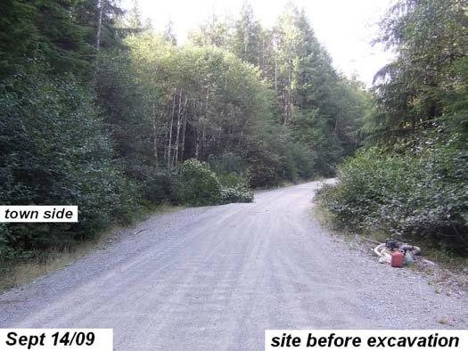
1 Project Completion Abstract Fish Passage Activity ( Engineering Activities) SUBMIT COMPLETED FORM TO DISTRICT MANAGER AND FIA ADMINISTRATOR AFTER PROJECT COMPLETION SECTION A GENERAL INFORMATION Recipient: (name & division) _BC Timber Sales Forest Region / District: Coast / South Island Watershed Name / Operating Area: Doobah / Nitnaht Road Type: ( check only one) ο Forest Service Road X Road Permit Road (pre-1995) ο Non-status road Road Name (formal): Roseander Main Road File / Ref. No.: R7655 Project Location: (road km): _ UTM Coordinates: (attach a key map): Zone 10 E N Stream Name / Stream Classification / Fish Species: _Doobah Trib / s-3 / Act Co Cm St Check one (article 5.2): X Conventional bridge/culvert OR ο Proprietary system or Non-conventional bridge / culvert FIA File No.: / FIA Investment Schedule No.: COTSA FIA Project No.: Priority Stream Fish Passage Restoration Project: ( check if applicable) ο Modifications to a Structure or Stream Channel ο Structural Repairs to a Major Culvert or Bridge ο Culvert Removal & Stream Channel Works X Culvert Removal & Major Culvert or Bridge Installation ο New or Replacement Bridge ο Structural Repairs to Bridge X New or Replacement Major Culvert ο Structural Repairs to Major Culvert PROJECT PRIORITY DETERMINATION Reasonable investment (pre-2008/09) in: X site plans ο designs ο pre-purchased materials Watershed Group Ranking: San Juan 1 Parker assessment (pre-2008/09) score: N/A ο Other Rationale: (attach justification) Fish Barrier New Method Crossing Name: Doobah Trib MFR Site No. / Structure No.: N/A /N/A Project Completion Date: Nov. 1,2009 1
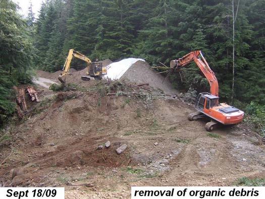
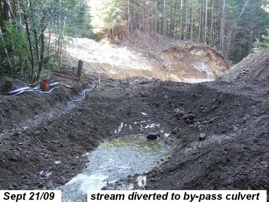
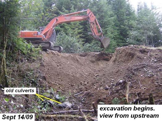
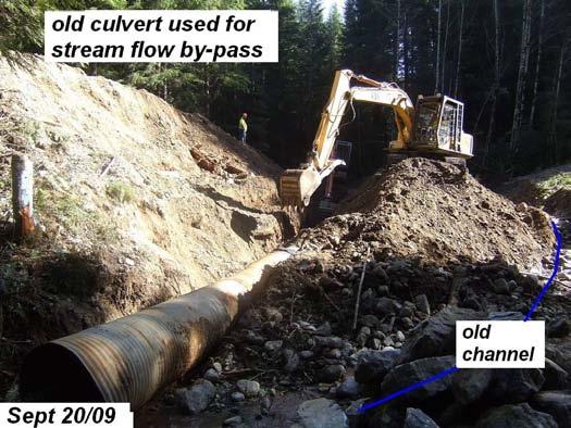
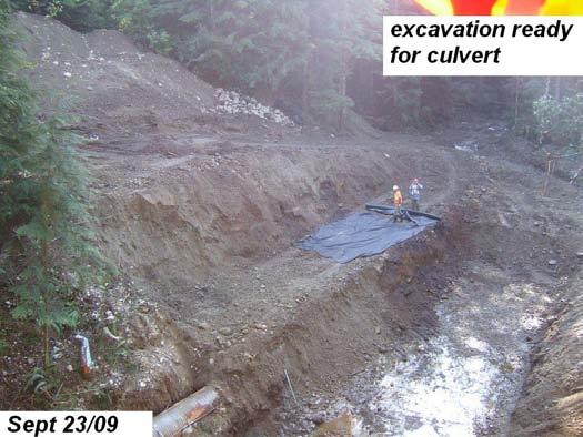
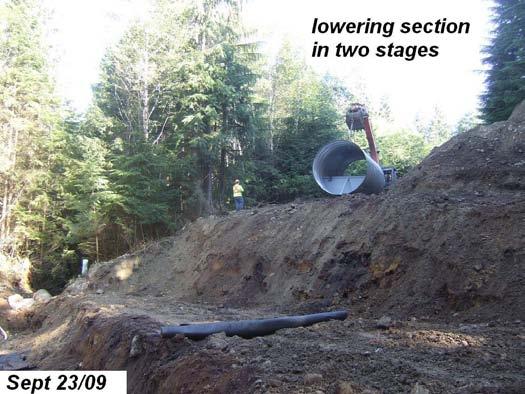
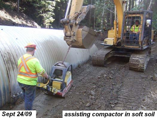
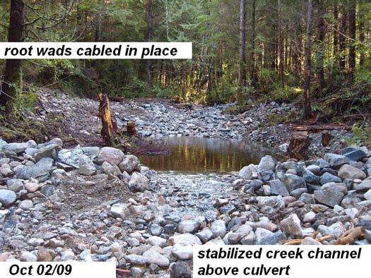
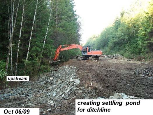
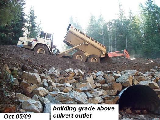
2 Nitinat Area - 15 km Rosander M/L - Culvert Replacement (COTSA ) September - October 2009 Objectives 1. Replacement of twin 900mm x 22 meter culverts that acted as a fish passage barrier with a single 3300mm x 25meter embedded culvert with six baffles, installed on a 4.0 % gradient. 2. Extension of the natural stream bed into the culvert with back fill to baffle height (1.32 m) for spawning & fish passage substrate. 3. Identification and definition of channel above and below crossing to ensure proper functioning of new culvert. Stabilization of channel above crossing. FIA Investment Schedule # COTSA Project Number: Fiscal year: 2009/2010 Author Noel Phillips, RFT Proponent/Implementing Partners BC Timber Sales Star Contracting Co. Ltd. Stonecroft Project Engineering Ltd. M. C. Wright & Associates Noel Phillips BRAT Expediting Fisheries and Oceans Canada Watershed / Stream Nitinat Lake/ Doobah Lake tributary Watershed Code: SANJWSD UTM (NAD83) Coordinates Zone:10 Easting: Northing: Location and Access This site is 13 km by air from the head of Nitinat Lake and 58km by air from Port Alberni. The D crossing is situated at 15 km on Rosander M/L which is accessed by way of the Port Alberni / Franklin / Nitinat Mainlines. Introduction and Rationale The unnamed tributary that eventually drains into Doobah Lake is considered highly valuable habitat for fish. Chinook (Oncorhynchus tshawytscha), coho (O. kisutch) and chum salmon (O. keta) as well as rainbow (and steelhead) (O. mykiss) and coastal cutthroat trout (O. clarki) species (MOE, 2009) Resident cut-throat trout were captured during this project. Doobah Lake is part of the greater Nitinat Lake fish and recreation area. There is 1 km+ of potential rearing channel above this culvert site that was previously inaccessible to fish. The previous twin 900 mm culverts (assessed in January 2009) were deemed a fish passage barrier in the S3-classified channel (Robert et al., 2009). Funding from the Forest Investment Account (FIA), administered through BC Timber Sales, was provided to upgrade the crossing. StoneCroft Project Engineering designed, prescribed and supervised the installation of the 3300mm x 25meter replacement culvert set at 4.0% gradient. M.C.Wright & Associates and Noel Phillips of BRAT Expediting provided environmental and construction monitoring for works conducted by Star Contracting Co. Ltd. in Sept. /October The culvert replacement project was intended to create year-round access to fish habitat above the crossing and to extend the natural stream bed into the culvert by backfilling the CMP to 1.32m with gravel of approved size for spawning and rearing use by fish. In order to ensure the new culvert would function as intended, the channel transition, into and out of the new culvert was reestablished and reconnected into this stream. Additionally, 75m of upstream channel stabilization was performed to ensure channel location into the culvert. 2
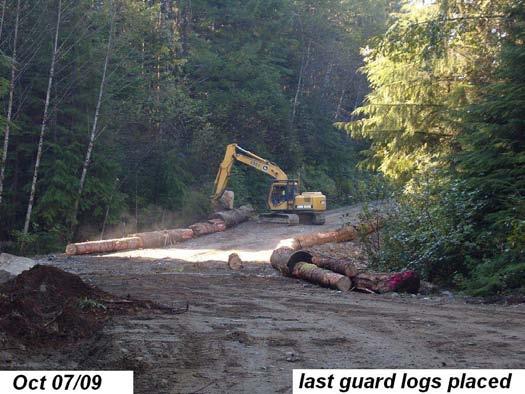
3 Installation and Construction The culvert replacement project included: The installation and armoring of the new 3300mm x 25 meter circular metal pipe (CMP) culvert. The use of approximately 30 loads of riprap from 3 quarries, north and south of the project to armor the culvert inlet, outlet and fill slopes. An additional 6 loads of rip rap for upstream channel stabilization. The removal and replacement of approx M 3 of the existing gravel fill. This included handling about 800M 3 of the fill material twice during excavation to elevate for loading out. An additional 300 M 3 of quarried rock to stabilize the road surface and complete final elevation design over a distance of 100+ m. Excavation and placement of correct creek gravel for filling the culvert to design elevation, for salmon spawning and rearing. The definition of channel banks over approximately 100 m (total) to ensure flows function correctly with new culvert. Expansion of banks and creation of pools upstream and at culvert intake and discharge to dissipate energy of flows and promote bank stability. General re-establishment of flows from the upper drainage through the culvert to 30m below the outlet. Environmental and Construction Monitoring On site monitoring was conducted by Noel Phillips of BRAT Expediting following the Sediment and Drainage Management Plan for this project, created by MC Wright & Assoc. and the Stonecroft engineered culvert design. Fish salvage was conducted by MC Wright & Associates. Environmental protective measures utilized throughout construction included inspection of machines for hydraulic leaks, spill kits, the dewatering of the culvert site during embedment with the use of trash pumps, and the preservation of riparian vegetation along channel banks. Expected Outputs The expected outputs for the culvert replacement project include the year-round access for fish to the upper channel habitat. Fish utilization is expected to improve, particularly above the crossing, now that the barrier has been removed and bed material in the culvert matches the channel bed. Costing Summary BCTS Budgeted Total $ 91, Contracted Labor and Materials $ 111, Environmental Monitoring and $ 38, Engineering Culvert Design and Installation BCTS Total Cost $ 150, For Further Information, Contact: Noel Phillips, RFT T.C. Hwy Chemainus, BC - V0R 1K4 brat@xplornet.com Michael Wright B.Sc. R.P. Bio M.C. Wright and Associates 2231 Neil Drive Nanaimo, BC - V9R 6T mike.wright@mcwrightonline.com References Ministry of Environment Fisheries Inventory FISS Fish Distributions Report. Website: fidq/main.do Robert, C. B., R.A. Petch, I.T. Anderton, and T.R. Strelioff Final Completion Report: Fish Passage & Culvert Assessment (PD09TC1062), SW Vancouver Island, B.C. Consultant s report prepared for BCTS Wright M. C. & Associates Sediment and Drainage Management Plan: Culvert Replacement near Doobah Lake Prepared for BCTS, August, Stonecroft Project Engineering Design # DOO-0014 Option #1 Prepared for BCTS, July 25,2009 3
4 4
5 5
6 6
Fish Passage Culvert Assessment for Cahilty Creek Watershed FIA Project #
 Fish Passage Culvert Assessment for Cahilty Creek Watershed FIA Project # 4602004 Prepared for Weyerhaeuser Company Ltd. Jason Ladyman R.P.F. 1550 Mission Flats Road PO Box 40 Kamloops BC V2C 5K3 Prepared
FINAL REPORT. Yonkers Creek Migration Barrier Removal Project Wonderstump Road Del Norte County. Submitted By:
 FINAL REPORT Yonkers Creek Migration Barrier Removal Project Wonderstump Road Del Norte County Submitted By: Del Norte County Community Development Department Yonkers Creek Migration Barrier Removal Project
Firth Creek Habitat Enhancement Project 1993
 Firth Creek Habitat Enhancement Project 1993 A. R. Langston December 1993 PWFWCP Report No. 77 The Peace/Williston Fish & Wildlife Compensation Program is a cooperative venture of BC Hydro and the provincial
COA-F17-F-1343 YEAR END REPORT
 DAVE MARSHALL SALMON RESERVE RESTORATION, MAINTENANCE, AND UPGRADES YEAR END REPORT Prepared for: Fish and Wildlife Compensation Program Prepared by: Edith Tobe, RPBio, Executive Director Box 1791, Squamish,
Fish Passage Culvert Inspection (FPCI) Nicklen Creek Watershed
 Nicklen Creek Watershed") Fish Passage Culvert Inspection (FPCI) Nicklen Creek Watershed FPCI Sites funded by FIA Prepared for: Tolko Industries Ltd., Okanagan Regional Woodlands & British Columbia Timber Sales, Okanagan-Shuswap
Fish Passage Culvert Inspection (FPCI) Nicklen Creek Watershed FPCI Sites funded by FIA Prepared for: Tolko Industries Ltd., Okanagan Regional Woodlands & British Columbia Timber Sales, Okanagan-Shuswap
Prescription to Restore Stream 11 (Orphan Channel) in the Burman River Watershed, March 2007
 in the Burman River Watershed, March 2007") Burman Watershed Funding Source: Land Based Investment Program Of the Forest Investment Account Investment #: COTFL196551 Project #; 6551001 Prescription to Restore Stream 11 (Orphan Channel) in the Burman
Burman Watershed Funding Source: Land Based Investment Program Of the Forest Investment Account Investment #: COTFL196551 Project #; 6551001 Prescription to Restore Stream 11 (Orphan Channel) in the Burman
Project Report for Marsh Creek and Albion River Instream Fish Barrier Removal Flynn Creek Road, CR 135, M.P. 8.1 and 8.3
 Project Report for Marsh Creek and Albion River Instream Fish Barrier Removal Flynn Creek Road, CR 135, M.P. 8.1 and 8.3 Project Title: Marsh Creek and Albion River Instream Fish Barrier Removal, Flynn
STREAM CLASSIFICATION AND MAPPING. Prepared For. MacMillan Bloedel Ltd. Menzies Bay Division BOX 6000, Campbell River V9W 5E1.
 STREAM CLASSIFICATION AND MAPPING OF STREAMS IN MENZIES AND OYSTER BAY Prepared For MacMillan Bloedel Ltd. Menzies Bay Division BOX 6000, Campbell River V9W 5E1 September 1998 a a North Island Biological
FISH PASSAGE IMPROVEMENT in California s Watersheds. Assessments & Recommendations by the Fish Passage Forum
 FISH PASSAGE IMPROVEMENT in California s Watersheds Assessments & Recommendations by the Fish Passage Forum FISH PASSAGE IMPROVEMENT in California s Watersheds The mission of the Fish Passage Forum is
Five Counties Salmonid Conservation Program - Fish Passage Design Workshop. February 2013
 Program - Aquatic Organisms and Stream Crossings Ecological Connectivity A watershed is a network of channels that drain a common boundary. Channel characteristics formed by interaction of precipitation,
Steelhead Society of BC. Thompson River Watershed Restoration and Enhancement Project #4 Nicola River Bank Stabilization and Enhancement Project
 Steelhead Society of BC Presents: Thompson River Watershed Restoration and Enhancement Project #4 Nicola River Bank Stabilization and Enhancement Project Application for Funding December 2013 1.0 BACKGROUND
Fish Passage Culvert Inspection (FPCI) 12 Sites on TFL 18 (FIA ) 1 Site on FL #A18688 (Thuya Creek) (FIA )
 12 Sites on TFL 18 (FIA ) 1 Site on FL #A18688 (Thuya Creek) (FIA )") Fish Passage Culvert Inspection (FPCI) 12 Sites on TFL 18 (FIA 444603) 1 Site on FL #A18688 (Thuya Creek) (FIA 450502) Prepared for: Canadian Forest Products Ltd. Vavenby Division Prepared by: Doug Wahl,
Fish Passage Culvert Inspection (FPCI) 12 Sites on TFL 18 (FIA 444603) 1 Site on FL #A18688 (Thuya Creek) (FIA 450502) Prepared for: Canadian Forest Products Ltd. Vavenby Division Prepared by: Doug Wahl,
Sub-watershed Summaries
 Project Description The Salmon Drift Creek Watershed Council (SDCWC) has focused their efforts in the Salmon River estuary for the past few years. The multifaceted partnership effort is nearing completion
STEELHEAD SURVEYS IN OMAK CREEK
 STEELHEAD SURVEYS IN OMAK CREEK 2002 Annual Report Prepared by Chris Fisher John Arterburn Colville Confederated Tribes Fish and Wildlife Department P.O. Box 150 Nespelem, WA 99155 Prepared for Project
Annual Report for Fiscal Year and Future Plans for the Tillamook Bay Watershed Council
 Annual Report for Fiscal Year 2012-2013 and Future Plans for the Tillamook Bay Watershed Council A report prepared for the Tillamook County Board of Commissioners August 2013 Table of Contents: Recently
Aquatic Organism Passage at Road-Stream Crossings CHUCK KEEPORTS FOREST HYDROLOGIST ALLEGHENY NATIONAL FOREST WARREN, PENNSYLVANIA
 Aquatic Organism Passage at Road-Stream Crossings CHUCK KEEPORTS FOREST HYDROLOGIST ALLEGHENY NATIONAL FOREST WARREN, PENNSYLVANIA TOPICS COVERED Aquatic Organism Passage (AOP) Benefits of AOP Crossings
FSOC Upstream Fish Passage Guidance Document
 FSOC Upstream Fish Passage Guidance Document STEP 1: Identify species and life stages in need of fish passage STEP 2: Identify fishway options and species applicability STEP 3 Fish passage criteria review
Eastern Brook Trout Joint Venture Annual Report The Nature Conservancy 2013
 Eastern Brook Trout Joint Venture Annual Report The Nature Conservancy 2013 2013 Annual Performance Report Enhancing Connectivity in the Ash-Black Rock Sub-basin of the West Branch Narraguagus River. Project
P.O. Box 65 Hancock, Michigan USA fax
 This PDF file is a digital version of a chapter in the 2005 GWS Conference Proceedings. Please cite as follows: Harmon, David, ed. 2006. People, Places, and Parks: Proceedings of the 2005 George Wright
Assessment of Elizabeth Lake as a Potential Candidate for Stocking
 Assessment of Elizabeth Lake as a Potential Candidate for Stocking Region 1, Nanaimo West Coast Planning Unit Ministry of Water, Land and Air Protection Prepared by: Laura Cassin Scott Silvestri 2002 1.0
Mid-Columbia Fisheries Enhancement Group Annual Report Fiscal Year 06: July 1, 2005 June 30, 2006
 Mid-Columbia Fisheries Enhancement Group Annual Report Fiscal Year 06: July 1, 2005 June 30, 2006 Mission Statement The mission of the Mid-Columbia Fisheries Enhancement Group is to restore self-sustaining
Lakelse Sockeye Recovery Program
 Lakelse Sockeye Recovery Program The Ninth Annual BC Interior Stewardship Workshop May 7 th and 8 th, 2013 DFO North Coast Resource Restoration Unit Presentation Overview History/background Stock and habitat
HEC 26 Aquatic Organism Passage Design Manual Evolution & Application
 HEC 26 Aquatic Organism Passage Design Manual Evolution & Application Sven Leon, P.E., Hydraulics Engineer Federal Highway Administration 2015 Alaska Fish Passage Meeting October 13 14, 2015 VTRC, Juneau,
The Calawah River System
 The Calawah River System The Calawah River is the largest tributary of the Bogachiel River and is formed by the confluence of the north and south forks of the Calawah. The two forks of the Calawah, CALAWAH
OKANAGAN RIVER RESTORATION INITIATIVE - FAQ
 OKANAGAN RIVER RESTORATION INITIATIVE - FAQ Initiative background: The health of the q awsitk w (Okanagan River) has been severely impacted by the channelization works that occurred in the mid-1950 s.
Executive Summary. Map 1. The Santa Clara River watershed with topography.
 Santa Clara River Steelhead Trout: Assessment and Recovery Opportunities December 2005 Prepared By: Matt Stoecker and Elise Kelley, Ph.D. University of California, Santa Barbara Prepared For: The Santa
(Revised February,2005) CULVERTS, BRIDGES, AND FORDS
 CULVERTS, BRIDGES, AND FORDS") GUIDE TO STREAM CROSSINGS (Revised February,2005) CULVERTS, BRIDGES, AND FORDS Culverts, bridges, and fords are all methods used to cross-streams. Culverts are the most common stream crossing structure.
GUIDE TO STREAM CROSSINGS (Revised February,2005) CULVERTS, BRIDGES, AND FORDS Culverts, bridges, and fords are all methods used to cross-streams. Culverts are the most common stream crossing structure.
Newaukum Watershed Culvert Assessment
 Newaukum Watershed Culvert Assessment Water Resource Inventory Area 23 Lewis County Conservation District Final Report By: Kelly Verd and Nikki Wilson July 2002 Funded by: Chehalis Fisheries Restoration
Gales Creek Fish Passage Assessment and Prioritization
 Gales Creek Fish Passage Assessment and Prioritization Washington County, Oregon Authors: Stephen Cruise, Environmental Resource Specialist Janet Oatney, Sr. Environmental Resource Specialist Washington
Lagoon Spawning Bed Rehabilitation
 Lagoon Spawning Bed Rehabilitation September 2011 Bowen Island B.C. Rebuilding the Spawning bed in the freshwater Lagoon at the Public Causeway, Crippen Regional Park Page 2 of 13 Bowen Island Lagoon Spawning
STREAM SURVEY File form No..
 scanned for KRIS THE RESOURCES AGENCY OF CALIFORNIA California Department of Fish and Game STREAM SURVEY File form No.. Date: September 4, 1969. NAME: North Fork Schooner Gulch Creek COUNTY: Mendocino.
South Fork Chehalis Watershed Culvert Assessment
 South Fork Chehalis Watershed Culvert Assessment Water Resource Inventory Area 23 Lewis County Conservation District Final Report By: Kelly Verd and Nikki Wilson March 2003 Funded by: The Washington State
Stream Assessment Cut-block: For: Island Timberlands Limited Partnership, Cameron Operation
 Stream Assessment Cut-block: 171214 For: Island Timberlands Limited Partnership, Cameron Operation Tony Norris Area Engineer Island Timberlands Cameron Operation Port Alberni D.G. Rigets E.I.A. CTech.
Abundance of Steelhead and Coho Salmon in the Lagunitas Creek Drainage, Marin County, California
 scanned for KRIS Abundance of Steelhead and Coho Salmon in the Lagunitas Creek Drainage, Marin County, California Prepared for: Marin Municipal Water District 220 Nellen Drive Corte Madera, California
SELBY CREEK SILVERADO TRAIL CULVERT FISH PASSAGE ASSESSMENT
 SELBY CREEK SILVERADO TRAIL CULVERT FISH PASSAGE ASSESSMENT NAPA COUNTY, CALIFORNIA PREPARED BY NAPA COUNTY RESOURCE CONSERVATION DISTRICT 1303 JEFFERSON ST. SUITE 500B NAPA, CALIFORNIA 94559 WWW.NAPARCD.ORG
Cheakamus River IR 11 Floodplain Restoration Final Report Project Number 13.CMS.01
 Cheakamus River IR 11 Floodplain Restoration Final Report Project Number 13.CMS.01 Prepared by: Squamish River Watershed Society Box 1791 Squamish, B.C. V08B 0B3 With financial support of: BC Hydro Fish
Terms and Conditions for Changes In and About A Stream Specified by MOE Habitat Officers, Cariboo Region
 Terms and Conditions for Changes In and About A Stream Specified by MOE Habitat Officers, Cariboo Region Section 42 (1) of the Water Regulation gives authority to a Habitat Officer to add specific conditions
Interim Guidance Fish Presence Absence
 Interim Guidance Fish Presence Absence Source: Forest Practices Act Guidance for Division 635 of the forest practices act dealing with stream classification when no fish surveys have been done (referenced
East Kitsap Peninsula WRIA 15 Salmon Habitat Restoration Strategy Summary
 East Kitsap Peninsula WRIA 15 Salmon Habitat Restoration Strategy Summary I. Specificity and Focus of the Strategy Strategic Planning Area The planning area for the East Kitsap Peninsula Salmon Habitat
Salmon and Migratol~Y Trout of the N,anaimo 'River lind Adjacent Streams (Revised 1,973)
") .. '.' ~! ~j-:-t. ~" I. This s~rie~ includes " unpublished preliminary' reports. ana Glatd rec
.. '.' ~! ~j-:-t. ~" I. This s~rie~ includes " unpublished preliminary' reports. ana Glatd rec
10 is bounded by wetlands between RM 1.8 and 3.1 on the south shore and more are scattered
 The Ozette System The Ozette watershed is made up of several lakes and large streams that combine to a total drainage area of 88.4 square miles. The most significant feature of the Ozette watershed is
Fish Passage at Road Crossings Assessment Boise National Forest FY 2004
 Culvert Inventory Summary 2004 - Boise National Forest Fish Passage at Road Crossings Assessment Boise National Forest FY 2004 Feather River at Road #135 Crossing By Michael S. Kellett, Fishery Biologist
1.Mill Creek Watershed Summary Description and Land Use
 1.Mill Creek Watershed Summary Description and Land Use Table xxx: Mill Creek Watershed Overview Watershed Size 31,435 acres/49.1 sq miles/ 127.1 sq km Elevation Range 5,594 feet [4,967-10,561] Stream
Kootenai River Habitat Restoration Program. Kootenai Tribe of Idaho - January 27, 2014 Presentation for Kootenai Valley Resource Initiative
 Kootenai River Habitat Restoration Program Kootenai Tribe of Idaho - January 27, 2014 Presentation for Kootenai Valley Resource Initiative Decline of native species Kootenai River White Sturgeon ENDANGERED
OVERVIEW OF MID-COLUMBIA FISHERIES ENHANCEMENT GROUP
 Mid-Columbia Fisheries Enhancement Group MISSION STATEMENT The Mid-Columbia Fisheries Enhancement Group is a non-profit organization dedicated to restoring selfsustaining salmon and steelhead populations
State of San Francisco Bay 2011 Appendix O Steelhead Trout Production as an Indicator of Watershed Health
 State of San Francisco Bay 2011 Appendix O Steelhead Trout Production as an Indicator of Watershed Health Gordon Becker and Katherine Smetak, Center for Ecosystem Management and Restoration 290 Introduction
Terms and Conditions for Changes In and About A Stream Specified by MWLAP Habitat Officers, Cariboo Region
 Terms and Conditions for Changes In and About A Stream Specified by MWLAP Habitat Officers, Cariboo Region Section 42 (1) of the Water Regulation gives authority to a Habitat Officer to add specific conditions
Kasaan to Goose Creek Road Project Project Description U.S. Army Corps of Engineers Permit The following table presents the mile point of the culverte
 Kasaan to Goose Creek Road Project Project Description U.S. Army Corps of Engineers Permit The following table presents the mile point of the culverted open water crossings, name of water crossing if known,
Union Pacific Railroad
 Input Questions: 404/401 Pre Application Meeting, December 18, 2013, Portland, Oregon 1. What is the project purpose and need? The purpose of the project is to improve the efficiency and average velocity
Benchmark Statement Respecting the Fish, Fish Habitat and Fisheries of Fish and Little Fish Lake, within the Taseko River Watershed.
 Benchmark Statement Respecting the Fish, Fish Habitat and Fisheries of Fish and Little Fish Lake, within the Taseko River Watershed. Information Supporting the Environmental Assessment of the Prosperity
Washington State Fish Passage Barrier Removal Projects. Casey Kramer, PE WSDOT State Hydraulics Engineer
 Washington State Fish Passage Barrier Removal Projects Casey Kramer, PE WSDOT State Hydraulics Engineer 2014 National Hydraulic Engineering Conference Iowa City, IA August 20 th, 2014 WSDOT Fish Passage
R & E Grant Application Biennium
 R & E Grant Application 15-17 Biennium Project #: 15-053 Elk River Hatchery Maintenance Project Information R&E Project Request: Total Project: Start Date: End Date: Organization: $116,262 $139,300 8/8/2016
Coquitlam Water Use Plan
 Coquitlam Water Use Plan Assessment of Fisheries Access to Streams Tributary To Coquitlam Reservoir COQMON#1 Study Period: September 1, 2006 May 31, 2007 Report Date: January 2008 Scott Ducharme Aquatec
MINISTRY OF ENVIRONMENT ENVIRONMENTAL STEWARDSHIP DIVISION FISH AND WILDLIFE BRANCH. Horsefly River Angling Management Plan
 MINISTRY OF ENVIRONMENT ENVIRONMENTAL STEWARDSHIP DIVISION FISH AND WILDLIFE BRANCH Horsefly River Angling Management Plan January 30 th, 2006 Area/Fishery Description The Horsefly River watershed provides
APPENDIX B: CATALOG OF COASTAL MENDOCINO COUNTY CULVERTS LOCATED ON FISH-BEARING STREAM REACHES
 APPENDIX B: CATALOG OF COASTAL MENDOCINO COUNTY CULVERTS LOCATED ON FISH-BEARING STREAM REACHES NOTE: This catalog contains two pages for each culvert included inventoried. The first page consists of location
APPENDIX B: CATALOG OF HUMBOLDT COUNTY CULVERTS LOCATED ON FISH-BEARING STREAM REACHES
 APPENDIX B: CATALOG OF HUMBOLDT COUNTY CULVERTS LOCATED ON FISH-BEARING STREAM REACHES NOTE: This catalog contains a single page for each culvert included in the inventory. Generally, they are ordered
CUSHMAN RESERVOIRS. Skokomish Watershed Monitoring Conference - Public Meeting Florian Leischner 9/17/2015
 CUSHMAN RESERVOIRS Skokomish Watershed Monitoring Conference - Public Meeting Florian Leischner 9/17/2015 CUSHMAN RESERVOIRS MONITORING Management and monitoring of Tacoma Power reservoirs Lake Cushman
Stevens Creek Corridor
 O F F I C E O F T H E D I R E C T O R O F P U B L I C W O R K S Stevens Creek Corridor Creek Restoration Project Volume Three Project Update: Creek Photos, Before & After BY GAIL SEEDS - PROJECT MANAGER,
SALMON FACTS. Chinook Salmon. Oncorhynchus tshawytscha
 SALMON FACTS Chinook Salmon Oncorhynchus tshawytscha Other names: king, tyee, blackmouth (immature) Average size: 10-15 lbs, up to 135 lbs Fall spawner; fall, spring, and summer runs Chinook salmon are
MCCAW REACH RESTORATION
 Final Report MCCAW REACH FISH RESTORATION PHASE B Jack McCaw Inland Empire Action Coalition http://www.wwccd.net/ Phone: 509-956-3777 Hours: 8:00-4:30 Walla Walla County Conservation District Snake River
Massachusetts Stream Crossing Case Studies
 Massachusetts Stream Crossing Case Studies Amy Singler Associate Director, River Restoration Program Carrie Banks River Continuity Coordinator Case Studies: Public Benefits: Movement of goods and people
Judd Lake Adult Sockeye Salmon Data Report 2012
 Judd Lake Adult Sockeye Salmon Data Report 2012 Prepared by: Nathan Weber, Biologist July 2013 The Judd Lake Project was made possible through a State of Alaska Designated Legislative Grant. This page
Results of the Kloiya River Resistivity Counter 2010
 Results of the Kloiya River Resistivity Counter 2010 Skeena Fisheries Report SK 157 Dean Peard 1 August 2010 1 Ministry of Environment Skeena Region Fish & Wildlife Branch Executive Summary A Logie 2100C
Oregon Department of Transportation (ODOT) Culvert Repair Fish Passage Pilot Programmatic Agreement Final ODFW Report
 Culvert Repair Fish Passage Pilot Programmatic Agreement Final ODFW Report") Oregon Department of Transportation (ODOT) Culvert Repair Fish Passage Pilot Programmatic Agreement 2014-17 Final ODFW Report Prepared by Pete Baki June 27, 2018 Table of Contents 1 Background 4 Culvert
Oregon Department of Transportation (ODOT) Culvert Repair Fish Passage Pilot Programmatic Agreement 2014-17 Final ODFW Report Prepared by Pete Baki June 27, 2018 Table of Contents 1 Background 4 Culvert
Assessment of Baseline Geomorphic Features at. Proposed Stream Crossings On The Proposed County Road 595. Marquette County, Michigan
 Assessment of Baseline Geomorphic Features at Proposed Stream Crossings On The Proposed County Road 595 Marquette County, Michigan Prepared for: Kennecott Eagle Minerals Company Marquette, Michigan Prepared
PRE- PROPOSAL FORM - Lewis River Aquatic Fund
 PRE- PROPOSAL FORM - Lewis River Aquatic Fund 1. Applicant organization. USDA Forest Service Gifford Pinchot National Forest 2. Organization purpose Resource management agency 3. Project manager (name,
Okanagan Sockeye Reintroduction
 Okanagan Sockeye Reintroduction Backgrounder Elders accounts, and other forms of Traditional Ecological Knowledge (TEK) tell us that many species of salmon once came into the Okanagan Valley and tell us
Packwood Hydroelectric Project Barrier Analysis December 12, 2006
 Packwood Hydroelectric Project Barrier Analysis December 12, 2006 Study Area Natural barriers to upstream fish passage on Lake Creek at RM 1.03 and RM 1.95 Snyder Creek culvert under the Project tailrace
Identifying Areas with Potential to Contain High Value Fish Habitat (HVFH) June 2007
 June 2007") Identifying Areas with Potential to Contain High Value Fish Habitat (HVFH) June 2007 1 High Value Fish Habitat INTENT: To apply added precautionary protection to those special areas deemed of high value
Identifying Areas with Potential to Contain High Value Fish Habitat (HVFH) June 2007 1 High Value Fish Habitat INTENT: To apply added precautionary protection to those special areas deemed of high value
Ecology of Place: What salmon need Eric Beamer Skagit River System Cooperative. November 2010
 Ecology of Place: What salmon need Eric Beamer Skagit River System Cooperative November 2010 Acknowledgements NOAA Fisheries NW Fisheries Science Center Tim Beechie George Pess Correigh Greene Talk overview
Creation of Fish and Wildlife Habitat on the Closed Salmon Harbour Mine in Minto, NB
 Creation of Fish and Wildlife Habitat on the Closed Salmon Harbour Mine in Minto, NB M. Coleman 1, R. Rutherford 2, RA Currie 3 1 NB Power 2 Thaumas Environmental Consultants Ltd 3 RA Currie Ltd. Location
Study Update Fish Distribution and Species Composition
 Study Update Fish Distribution and Species Composition Goals and Study Area Gain a better understanding of fish species composition and abundance in waters associated with the Packwood Lake Hydroelectric
Stream Crossings I: Engineering and Design Approaches to Provide Fish Passage at Culvert Slipline Projects in Connecticut
 University of Massachusetts - Amherst ScholarWorks@UMass Amherst International Conference on Engineering and Ecohydrology for Fish Passage International Conference on Engineering and Ecohydrology for Fish
Kispiox River Steelhead: Summary of Current Data and Status Review, James S. Baxter 1
 Kispiox River Steelhead: Summary of Current Data and Status Review, 1997 James S. Baxter 1 British Columbia Ministry of Environment, Lands, and Parks Fisheries Branch Skeena Region Box 5000 Smithers, B.C.
APPENDIX D: North Fork Nooksack Sub-basin Report
 APPENDIX D: North Fork Nooksack Sub-basin Report WHATCOM COUNTY FISH PASSAGE ASSESSMENT SUBBASIN REPORT NORTH FORK NOOKSACK RIVER Description of Sub-basin The North Fork Nooksack River originates at an
Fish Habitat Restoration and Monitoring in Southeast Washington. Andy Hill Eco Logical Research, Inc.
 Fish Habitat Restoration and Monitoring in Southeast Washington Andy Hill Eco Logical Research, Inc. Fish Habitat Restoration and Monitoring in Southeast Washington Talk overview: Restoration projects
Climate Change Adaptation and Stream Restoration. Jack Williams;
 Climate Change Adaptation and Stream Restoration Jack Williams; jwilliams@tu.org 1 Goals for this presentation Develop strategies for adapting streams to climate impacts by Thinking like a watershed Understanding
R & E Grant Application 15 Biennium
 R & E Grant Application 15 Biennium Project #: 15-026 Project Information R&E Project Request: Total Project: Start Date: End Date: Organization: Cedar Creek Hatchery Raceway and Pump Replacement $500,000.00
2012 Bring Back the Natives Awarded Projects
 2012 Bring Back the Natives Awarded Projects EZG # Organization Project Title Project Description Location Description Total Award Amount Grantee Non- Federal Match 31904 Sanctuary Forest, Inc. Mattole
Steelhead Sport Fishing Regulations Proposals Vancouver Island Region for April 1, 2007
 Steelhead Sport Fishing Regulations Proposals Vancouver Island Region for April 1, 2007 Sport fishing regulations governing steelhead fishing have changed many times over the past 30 years. Generally the
Shovelnose Creek Off-Channel Complex Berm Repair
 Shovelnose Creek Off-Channel Complex Berm Repair Recent high discharge events have put valuable off-channel salmonid rearing and spawning habitat at risk in the upper Squamish River. This document is a
Packwood Lake Intake Screen Velocity Test Report for Energy Northwest's Packwood Lake Hydroelectric Project FERC No Lewis County, Washington
 for Energy Northwest's Packwood Lake Hydroelectric Project FERC No. 2244 Lewis County, Washington Submitted to P.O. Box 968 Richland, Washington 99352-0968 Submitted by EES Consulting 1155 North State
DEADWOOD CREEK FISH PASSAGE IMPROVEMENT PROJECT
 DEADWOOD CREEK FISH PASSAGE IMPROVEMENT PROJECT Coho Salmon in Deadwood Creek Project Area - November 2, 2004 FINAL REPORT National Fish and Wildlife Foundation Project #2002-0368-014 CA Department of
Southern Oregon Coastal Cutthroat Trout
 Species Management Unit Description Southern Oregon Coastal Cutthroat Trout The Southern Oregon Coastal Cutthroat Trout SMU includes all populations of cutthroat trout inhabiting ocean tributary streams
PROJECT TO INSTALL LARGE WOOD HABITAT STRUCTURES IN THE CARMEL RIVER USING CALIFORNIA DEPARTMENT OF FISH AND GAME GRANT FUNDS
 PROJECT TO INSTALL LARGE WOOD HABITAT STRUCTURES IN THE CARMEL RIVER USING CALIFORNIA DEPARTMENT OF FISH AND GAME GRANT FUNDS The Monterey Peninsula Water Management District (MPWMD), in cooperation with
1998 Willow Creek Downstream Migrant Trap Report. Draft. Prepared By: C. A. Walker. Lower Trinity Ranger District. Six Rivers National Forest
 1998 Willow Creek Downstream Migrant Trap Report Draft Prepared By: C. A. Walker Lower Trinity Ranger District Six Rivers National Forest September 1998 Executive Summary The downstream migrant trap was
OREGON DEPARTMENT OF FISH AND WILDLIFE ROGUE FISH DISTRICT REPORT
 OREGON DEPARTMENT OF FISH AND WILDLIFE ROGUE FISH DISTRICT REPORT TITLE: Upper Rogue Smolt Trapping Project, 1999 STREAM: Big Butte, Little Butte, South Fork Big Butte, Slate and West Fork Evans Creeks
Fish Tech Weekly Outline January 14-18
 Fish Tech Weekly Outline January 14-18 TOPICS: salmon, trout, and char in Southeast Alaska salmonid identification overview salmonid life cycle and stages salmonid freshwater and marine distribution/residence
The Blue Heron Slough Conservation Bank
 1 The Blue Heron Slough Conservation Bank CONSERVATION BANKING July 19-23, 2010 CASE STUDY SERIES The Blue Heron Slough Conservation Bank (Washington) I. OVERVIEW & BACKGROUND: Location: Snohomish River
For next Thurs: Jackson et al Historical overfishing and the recent collapse of coastal ecosystems. Science 293:
 For next Thurs: Jackson et al. 2001. Historical overfishing and the recent collapse of coastal ecosystems. Science 293: 629-637. Resource: means of supplying a want or deficiency, from French resourdre
Culvert Design for Low and High Gradient Streams in the Midwest. Dale Higgins, Hydrologist Chequamegon-Nicolet National Forest
 Culvert Design for Low and High Gradient Streams in the Midwest Dale Higgins, Hydrologist Chequamegon-Nicolet National Forest Overview Culvert Design Considerations Hydraulic Terms Culvert Impacts Low
Redd Dewatering and Juvenile Salmonid Stranding in the Lower Feather River,
 Redd Dewatering and Juvenile Salmonid Stranding in the Lower Feather River, 2005-2006 Interim Report for NOAA Fisheries Prepared by: California Department of Water Resources Division of Environmental Services
Tuolumne River Gravel Introduction
 Tuolumne River Gravel Introduction 2000 2003 Tuolumne River La Grange Gravel Addition, Phase II Course Sediment Replenishment Program Tuolumne River Salmonid Habitat Improvement Project River Mile 49.9
JAP Additional Information Sheet
 JAP Additional Information Sheet Block 15: Purpose and Need The USACE purpose of the project is to provide a safe and reliable whitewater park for the recreational public in a city park, which will provide
1 INTRODUCTION AND SUMMARY
 December 10, 2012 Pacific Booker Minerals 1702 1166 Alberni Street Vancouver, British Columbia V6E 3Z3 Erik Tornquist Executive VP and COO Dear Mr. Erik Tornquist: 1 INTRODUCTION AND SUMMARY This letter
Downstream Migrant Trapping in Russian River Mainstem, Tributaries, and Estuary
 Downstream Migrant Trapping in Russian River Mainstem, Tributaries, and Estuary Introduction In September 2008, the National Marine Fisheries Service issued the Russian River Biological Opinion, which
Don Pedro Project Relicensing
 Don Pedro Project Relicensing M ODESTO I RRIGATION D ISTRICT TURLOCK I RRIGATION D ISTRICT FERC PROJECT N O. 2299 Resident Fish in Don Pedro Reservoir Don Pedro Reservoir Fish Stocking (1971-Present) CDFG
1.Warm Springs Creek (Anaconda) Watershed Description and Land Use
 Watershed Description and Land Use") 1.Warm Springs (Anaconda) Watershed Description and Land Use Table xxx: Warm Springs Watershed Overview Watershed Size 92,288 acres/144.2 sq miles/373.6 sq km Elevation Range 5,781 feet [4,800-10,581]
1.Warm Springs (Anaconda) Watershed Description and Land Use Table xxx: Warm Springs Watershed Overview Watershed Size 92,288 acres/144.2 sq miles/373.6 sq km Elevation Range 5,781 feet [4,800-10,581]
Ecology of Columbia River redband trout (Oncorhynchus mykiss gairdneri) in high desert streams
 in high desert streams") Ecology of Columbia River redband trout (Oncorhynchus mykiss gairdneri) in high desert streams Dry Creek October 2012 Chris A. Walser Ph.D., Professor of Biology Department of Biology and Environmental
Ecology of Columbia River redband trout (Oncorhynchus mykiss gairdneri) in high desert streams Dry Creek October 2012 Chris A. Walser Ph.D., Professor of Biology Department of Biology and Environmental
3. The qualification raised by the ISRP is addressed in #2 above and in the work area submittal and review by the ISRP as addressed in #1.
 Please find attached a response from The Confederated Tribes of the Warm Springs Reservation of Oregon (CTWSRO) for Project # 2008-301-00, Habitat Restoration Planning, Design and Implementation within