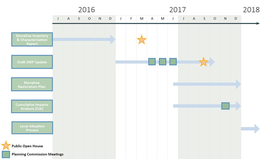
Klickitat County Shoreline Master Program Update. Open House March 15, 2017
|
|
|
- Katrina Davidson
- 5 years ago
- Views:
Transcription
1 Klickitat County Shoreline Master Program Update Open House March 15, 2017

2 Agenda 6:00 6:10 Welcome 6:10 6:40 Presentation SMP Update Process Shoreline Analysis review 6:40 8:00 Open House
3 Topics SMP Process SMP Update and Key Issues Shoreline Inventory and Characterization Next Steps
4 What is an SMP? A comprehensive shoreline land-use plan that includes policies and regulations for the use and development of the shoreline
5 Shoreline Management Act (SMA) Purpose: Balance Shoreline Priorities 1. Preferred uses Water dependent Water enjoyment Single Family Development 2. Promote public access 3. Protection of natural environment
6 An SMP will not: Retroactively apply to past actions. Require modifications to existing land uses or developments. Alter ongoing agricultural activities
7 Shoreline Master Program Includes Goals Policies Shoreline designations Regulations
8 Regulatory Content Public Access Shoreline Uses and Modifications Vegetation Conservation In-water Activities Upland Activities


9 Determine Preliminary Jurisdiction WE ARE HERE Inventory & Analysis We are here SMP - Environment Designations - Goals - Policies - Regulations Cumulative Impacts Analysis Local Adoption Open House Open House Restoration Plan Ecology Review and Adoption
10
11 Waters Shoreline Jurisdiction Streams & rivers with mean annual flow of 20 cfs or greater Lakes 20 acres or larger Shorelands Upland areas 200 feet from OHWM Associated wetlands (within 100-year floodplain or with hydrologic connection) FEMA floodway and up to 200 feet landward of the floodway when within the 100 year floodplain.
12 Shoreline Jurisdiction Bowman Creek Major Creek, West Fork Buck Creek Mill Creek Camas Ditch and Outlet Creek Mill Pond Cave Creek Paterson Slough Chamberlain Lake Rattlesnake Creek Columbia River* Rowland Lake Dead Canyon Creek Snyder Canyon Creek Dry Creek Summit Creek Frasier Creek Swale Creek Gilmer Creek Trout Creek Holmes Creek Trout Lake Creek* Horsethief Lake White Creek Klickitat River* White Salmon River* Little Klickitat River Little White Salmon River Major Creek
13 Shoreline Inventory & Analysis Report Develops current understanding of existing conditions (= baseline) Assesses existing shoreline functions Assesses current land use and identifies likely future changes
14 How is it used? Background for SMP policies and regulations Supports Shoreline Designations Precursor to Restoration Plan Provides management recommendations It is not a regulatory document
15 Elements: Shoreline Inventory Current Land Use Habitats and Species Zoning Shoreline Modifications Land Ownership Water Quality Impairments Public Access Channel Migration Zones (TBD) Land Cover Floodplains and Wetlands Surface Water System Geologic Units Soils Geological Hazards


16 Shoreline Characterization Resources Sources Shoreline Inventory County Data Watershed Assessments Salmon Recovery Plans Government Reports Scientific Literature Local knowledge
17 Shoreline Characterization Assessment Units Used to facilitate description of existing conditions Reaches Developed for informational purposes and not as regulatory boundaries Although reach scale analysis does help develop future environment designations

18 Shoreline Inventory Map Folio
19 Report Contents Background Ecosystem context Shoreline inventory review Analysis of functions Land Use Analysis

20 White Salmon River Watershed White Salmon River Trout Lake Creek Cave Creek Dry Creek Little White Salmon River Rattlesnake Creek Gilmer Creek Buck Creek Major Creek


21 White Salmon River Watershed Existing Land Uses Agriculture Government land Forest Resources Residential (Trout Lake, BZ Corner, Husum) Public Access USFS sites at Husum and BZ Corner Former Northwestern Lake (WDFW)


22 White Salmon River Watershed Other Conditions Wild and Scenic designation between Gilmer and Buck Creeks Condit Dam removal Restoration Opportunities Fish passage and habitat improvement upstream of former Condit Dam Improve baseflow and water quality input

23 Klickitat River Watershed Klickitat River Little Klickitat River Bowman Creek Camas Ditch and Outlet Creek Mill Pond Dead Canyon Creek Frasier Creek Holmes Creek Mill Creek Summit Creek Swale Creek Snyder Canyon Creek Trout Creek White Creek


24 Klickitat River Watershed Existing Land Uses Predominantly zoned Open Space Some Agriculture and Resource Lands Residential (Klickitat, Lyle, and outside Goldendale) Public Access Klickitat River Trail (31 miles) Six WDFW Water Access sites, including three concrete boat ramps Extensive public lands

25 Klickitat River Watershed Other Conditions Wild and Scenic designation on lower 11 miles Conboy Lake National Wildlife Refuge Old mill site at lower Snyder Canyon Creek Restoration Opportunities Streambank revegetation for temperature control Improve in-stream flow Improve fish habitat and remove barriers


26 Columbia River Columbia River Lake Umatilla Rowland Lake Chamberlain Lake Horsethief Lake Paterson Slough

")
27 Columbia River Existing Land Uses Industrial and transportation uses Open space, Agriculture, and Rural Residential Unincorporated urban areas (Lyle, Wishram, Dallesport, Alderdale, Roosevelt) Public Access Rowland Lake and Doug s Beach Park State Parks Corps of Engineer managed sites Sailboard and Marina Parks (Port of Klickitat) Informal access points


28 Columbia River Other Conditions National Scenic Area John Day Dam, The Dalles Dam, Bingen Harbor Restoration Opportunities Riparian Revegetation Habitat enhancement Limited by dams, armoring and dredging
29 Contact Information Mo-chi Lindblad Planning Director Klickitat County (509) Website
Mid-Columbia Fisheries Enhancement Group Annual Report Fiscal Year 06: July 1, 2005 June 30, 2006
 Mid-Columbia Fisheries Enhancement Group Annual Report Fiscal Year 06: July 1, 2005 June 30, 2006 Mission Statement The mission of the Mid-Columbia Fisheries Enhancement Group is to restore self-sustaining
TESTIMONY OF THE COLUMBIA RIVER TREATY TRIBES BEFORE PACIFIC FISHERIES MANAGEMENT COUNCIL
 Agenda Item E.2.f Supplemental Tribal Report April 2012 TESTIMONY OF THE COLUMBIA RIVER TREATY TRIBES BEFORE PACIFIC FISHERIES MANAGEMENT COUNCIL April 2, 2012 Seattle, WA Good day Mr. Chairman and members
OVERVIEW OF MID-COLUMBIA FISHERIES ENHANCEMENT GROUP
 Mid-Columbia Fisheries Enhancement Group MISSION STATEMENT The Mid-Columbia Fisheries Enhancement Group is a non-profit organization dedicated to restoring selfsustaining salmon and steelhead populations
3. The qualification raised by the ISRP is addressed in #2 above and in the work area submittal and review by the ISRP as addressed in #1.
 Please find attached a response from The Confederated Tribes of the Warm Springs Reservation of Oregon (CTWSRO) for Project # 2008-301-00, Habitat Restoration Planning, Design and Implementation within
The Calawah River System
 The Calawah River System The Calawah River is the largest tributary of the Bogachiel River and is formed by the confluence of the north and south forks of the Calawah. The two forks of the Calawah, CALAWAH
Trout Unlimited Comments on the Scope of Environmental Impact Statement for the Constitution Pipeline Project, Docket No. PF12-9
 October 9, 2012 Kimberly D. Bose, Secretary Federal Energy Regulatory Commission 888 First Street, NE, Room 1A Washington, DC 20426 RE: Trout Unlimited Comments on the Scope of Environmental Impact Statement
FISH PASSAGE IMPROVEMENT in California s Watersheds. Assessments & Recommendations by the Fish Passage Forum
 FISH PASSAGE IMPROVEMENT in California s Watersheds Assessments & Recommendations by the Fish Passage Forum FISH PASSAGE IMPROVEMENT in California s Watersheds The mission of the Fish Passage Forum is
Oregon Estuaries defined: (Goal 16)
") Bob Bailey, Manager, Oregon Coastal Management Program Oregon Estuaries defined: (Goal 16) includes estuarine water, tidelands, tidal marshes, and submerged lands. Estuaries extend upstream to the head
Bob Bailey, Manager, Oregon Coastal Management Program Oregon Estuaries defined: (Goal 16) includes estuarine water, tidelands, tidal marshes, and submerged lands. Estuaries extend upstream to the head
FINAL REPORT. Yonkers Creek Migration Barrier Removal Project Wonderstump Road Del Norte County. Submitted By:
 FINAL REPORT Yonkers Creek Migration Barrier Removal Project Wonderstump Road Del Norte County Submitted By: Del Norte County Community Development Department Yonkers Creek Migration Barrier Removal Project
Puget Sound Nearshore Ecosystem Restoration Project Restore America s Estuaries Conference 2012 Tampa, FL
 Restore America s Estuaries Conference 2012 Tampa, FL presented by: Theresa Mitchell, WA Dept. of Fish & Wildlife Nearshore General Investigation Change Analysis: Comparison of historical and current
Analysis Data Sources
 Page Technical Appendix D 1 SMP Analysis Data Sources the set bathymetry levee riprap mine lakebath_arc FloodHazardD ata.mdb\flood HazardZoneCo mponents\fhcl evee FloodHazardD ata.mdb\flood HazardZoneCo
P.O. Box 65 Hancock, Michigan USA fax
 This PDF file is a digital version of a chapter in the 2005 GWS Conference Proceedings. Please cite as follows: Harmon, David, ed. 2006. People, Places, and Parks: Proceedings of the 2005 George Wright
Revised Draft WRIA 20 Inventory and Characterization Report (ICR)
") Revised Draft WRIA 20 Inventory and Characterization Report (ICR) Prepared by Miranda Wecker and Rebekah Gentry UW Olympic Natural Resources Center June 30, 2011 1 P a g e Table of Contents Introduction
Revised Draft WRIA 20 Inventory and Characterization Report (ICR) Prepared by Miranda Wecker and Rebekah Gentry UW Olympic Natural Resources Center June 30, 2011 1 P a g e Table of Contents Introduction
Funding Habitat Restoration Projects for Salmon Recovery in the Snake River Region SRFB Grant Round Version: 2/19/16
 2016 SRFB Grant Round Version: 2/19/16 Funding Habitat Restoration Projects for Salmon Recovery in the Snake River Region The Project Funding Process Presented by the Snake River Salmon Recovery Lead Entity
INDIANA REGIONAL GENERAL CONDITIONS FOR THE STATE OF INDIANA
 INDIANA REGIONAL GENERAL CONDITIONS FOR THE STATE OF INDIANA These regional conditions are in addition to but do not supersede the requirements in the Federal Register (Volume 82 No. 4 of January 6, 2017).
MCCAW REACH RESTORATION
 Final Report MCCAW REACH FISH RESTORATION PHASE B Jack McCaw Inland Empire Action Coalition http://www.wwccd.net/ Phone: 509-956-3777 Hours: 8:00-4:30 Walla Walla County Conservation District Snake River
WRIA 20 Inventory and Characterization Report (ICR)
") WRIA 20 Inventory and Characterization Report (ICR) Prepared by Miranda Wecker and Rebekah Gentry UW Olympic Natural Resources Center Revised June 6, 2011 Table of Contents Introduction Introduction...
WRIA 20 Inventory and Characterization Report (ICR) Prepared by Miranda Wecker and Rebekah Gentry UW Olympic Natural Resources Center Revised June 6, 2011 Table of Contents Introduction Introduction...
1.Mill Creek Watershed Summary Description and Land Use
 1.Mill Creek Watershed Summary Description and Land Use Table xxx: Mill Creek Watershed Overview Watershed Size 31,435 acres/49.1 sq miles/ 127.1 sq km Elevation Range 5,594 feet [4,967-10,561] Stream
Public Notice. Corps File No. LRE Date: March 19, 2017 Expires: March 18, 2022
 US Army Corps of Engineers Detroit District Public Notice Corps File No. LRE-2016-00006-100 Date: March 19, 2017 Expires: March 18, 2022 PUBLIC NOTICE ANNOUNCING REGIONAL CONDITIONS AND WATER QUALITY CERTIFICATIONS
Washington State Fish Passage Barrier Removal Projects. Casey Kramer, PE WSDOT State Hydraulics Engineer
 Washington State Fish Passage Barrier Removal Projects Casey Kramer, PE WSDOT State Hydraulics Engineer 2014 National Hydraulic Engineering Conference Iowa City, IA August 20 th, 2014 WSDOT Fish Passage
Chagrin River TMDL Appendices. Appendix F
 Appendix F The following are excerpts from the Eastern Brook Trout Joint Venture s Conservation Strategy (Working Draft v.6), Conserving the Eastern Brook Trout: Strategies for Action Found at: http://www.easternbrooktrout.org/constrategy.html
Environmental Review and Permitting for Wild Trout
 Environmental Review and Permitting for Wild Trout Tom Shervinskie Wild Trout Summit Watershed Analysis Section August 26, 2017 Division of Environmental Services The mission of the Pennsylvania Fish and
Columbia Lake Dam Removal Project
 Columbia Lake Dam Removal Project The Columbia Lake dam located 1/4 mile upstream of the Paulins Kill River's confluence with the Delaware River in Knowlton Township, Warren County has been proposed for
PROTECTING LAND & RESTORING RIVERS FOR SALMON & STEELHEAD
 PROTECTING LAND & RESTORING RIVERS FOR SALMON & STEELHEAD Whychus Creek at Camp Polk Meadow Preserve. Photo: Russ McMillan Top photo: Deschutes River Conservancy 1 Photo: Byron Dudley A Unique Collaboration
COLUMBIA LAKE DAM REMOVAL PROJECT
 COLUMBIA LAKE DAM REMOVAL PROJECT Major Goals of the Columbia Lake Dam Removal: Reconnect 10 miles of the Paulins Kill River to the Delaware River, restoring natural flow regime and sediment transport.
Information for File # SEW
 Information for File #2014-02744-SEW Applicant: Minnesota Department of Transportation (MnDOT), District 3; c/o Mr. Robert Nibbe Corps Contact: Sarah Wingert, U.S. Army Corps of Engineers, 180 5 th Street
What is a River Basin Restoration Priority? 1. Criteria for Selecting a Targeted Local Watershed (TLW) 2. Hiwassee River Basin Overview 3
 2. Hiwassee River Basin Overview 3") Hiwassee River Basin Restoration Priorities 2008 TABLE OF CONTENTS Introduction 1 What is a River Basin Restoration Priority? 1 Criteria for Selecting a Targeted Local Watershed (TLW) 2 Hiwassee River
Hiwassee River Basin Restoration Priorities 2008 TABLE OF CONTENTS Introduction 1 What is a River Basin Restoration Priority? 1 Criteria for Selecting a Targeted Local Watershed (TLW) 2 Hiwassee River
The Blue Heron Slough Conservation Bank
 1 The Blue Heron Slough Conservation Bank CONSERVATION BANKING July 19-23, 2010 CASE STUDY SERIES The Blue Heron Slough Conservation Bank (Washington) I. OVERVIEW & BACKGROUND: Location: Snohomish River
Clallam County Shoreline Master Program Update. Draft Public Land/Access Inventory Emphasis on Shoreline Public Access
 Clallam County Shoreline Master Program Update Draft Public Land/Access Inventory Emphasis on Shoreline Public Access Outline Public Lands Public Shoreline Access Inventory Marine Shoreline Freshwater
ADOPT-A-STREAM WATERSHED APPROACH COMMUNITY-BASED STEWARDSHIP. Nova Scotia Salmon Association March 2005
 ADOPT-A-STREAM A WATERSHED APPROACH TO COMMUNITY-BASED STEWARDSHIP Nova Scotia Salmon Association March 2005 This manual is a revised and updated version of the 1994 Adopt-a-Stream manual that was prepared
Pend Oreille County Shoreline Master Program User Guide April Funded through a grant from the Washington State Department of Ecology
 Pend Oreille County Shoreline Master Program User Guide April 2016 Funded through a grant from the Washington State Department of Ecology TABLE OF CONTENTS 1 Shoreline Master Program Overview 1 2 Frequently
1.Warm Springs Creek (Anaconda) Watershed Description and Land Use
 Watershed Description and Land Use") 1.Warm Springs (Anaconda) Watershed Description and Land Use Table xxx: Warm Springs Watershed Overview Watershed Size 92,288 acres/144.2 sq miles/373.6 sq km Elevation Range 5,781 feet [4,800-10,581]
1.Warm Springs (Anaconda) Watershed Description and Land Use Table xxx: Warm Springs Watershed Overview Watershed Size 92,288 acres/144.2 sq miles/373.6 sq km Elevation Range 5,781 feet [4,800-10,581]
Columbia Lake Dam Removal Project
 Columbia Lake Dam Removal Project Major Goals of the Columbia Lake Dam Removal: Reconnect 10 miles of the Paulins Kill River to the Delaware River, restoring natural flow regime and sediment transport.
ELK RIVER WATERSHED ACTION PLAN
 ELK RIVER WATERSHED ACTION PLAN Prepared for The Elk River Watershed Council Prepared by Chris Massingill Mainstream Contracting South Coast Watershed Council September 2001 South Coast Watershed Council
Sub-watershed Summaries
 Project Description The Salmon Drift Creek Watershed Council (SDCWC) has focused their efforts in the Salmon River estuary for the past few years. The multifaceted partnership effort is nearing completion
What happens to Oregon s tidal wetlands with sea level rise?
 What happens to Oregon s tidal wetlands with sea level rise? Laura Brophy Estuary Technical Group Institute for Applied Ecology Corvallis, OR Laura@appliedeco.org Project maps future tidal wetlands, predicts
PROJECT TO INSTALL LARGE WOOD HABITAT STRUCTURES IN THE CARMEL RIVER USING CALIFORNIA DEPARTMENT OF FISH AND GAME GRANT FUNDS
 PROJECT TO INSTALL LARGE WOOD HABITAT STRUCTURES IN THE CARMEL RIVER USING CALIFORNIA DEPARTMENT OF FISH AND GAME GRANT FUNDS The Monterey Peninsula Water Management District (MPWMD), in cooperation with
Illinois Lake Management Association Conference March 23, 2018 By Trent Thomas Illinois Department of Natural Resources Division of Fisheries
 Illinois Lake Management Association Conference March 23, 2018 By Trent Thomas Illinois Department of Natural Resources Division of Fisheries Sources of Habitat Impairment Sedimentation Channelization
Water in the Deschutes Who needs it?
 Water in the Deschutes Who needs it? Rivers and streams over appropriation and flow alteration. Junior water right holders production agriculture. The Cities long-term supply for growing populations. Climate
6. FRESHWATER REACH SUMMARY
 6. FRESHWATER REACH SUMMARY This chapter describes the freshwater shorelines that are within the jurisdiction of the County s SMP (in WRIAs 18, 19, and a portion of 17, excluding incorporated areas) (see
Western native Trout Status report
 Bull trout (Salvelinus confluentus) Data: Draft Recovery Plan, USFWS, 2002; FR Final Critical Habitat Rule - 2005 Partners: ID, MT, OR, WA, NV, FWS, FS, BLM, NPS, Tribes, AK, Canada Species Status review:
LIFE HISTORY DIVERSITY AND RESILIENCE
 LIFE HISTORY DIVERSITY AND RESILIENCE SPRING CHINOOK IN THE WILLAMETTE RIVER BASIN Kirk Schroeder Brian Cannon Luke Whitman Paul Olmsted Oregon Department of Fish and Wildlife Corvallis Research Lab Thanks
MUCKLESHOOT INDIAN TRIBE Fisheries Division nd Avenue SE Auburn, Washington Phone: (253) Fax: (253)
 Fax: (253)") MUCKLESHOOT INDIAN TRIBE Fisheries Division 39015-172nd Avenue SE Auburn, Washington 98092-9763 Phone: (253) 939-3311 Fax: (253) 931-0752 U.S. Army Corps of Engineers Regulatory Branch Attn: Karen Urelius
MUCKLESHOOT INDIAN TRIBE Fisheries Division 39015-172nd Avenue SE Auburn, Washington 98092-9763 Phone: (253) 939-3311 Fax: (253) 931-0752 U.S. Army Corps of Engineers Regulatory Branch Attn: Karen Urelius
Big Spring Creek Habitat Enhancement and Fishery Management Plans
 Big Spring Creek Habitat Enhancement and Fishery Management Plans November 5, 2012 Big Spring Events and Activities Center Newville, PA Charlie McGarrell Regional Habitat Biologist Pennsylvania Fish and
A Comparison of Western Watershed Councils. Presentation Prepared by Jeff Salt, Great Salt Lakekeeper
 A Comparison of Western Watershed Councils Presentation Prepared by Jeff Salt, Great Salt Lakekeeper Presentation Overview Introduction Jordan River Watershed Council Lower Boise Watershed Council Clackamas
Aquatic Organism Passage at Road-Stream Crossings CHUCK KEEPORTS FOREST HYDROLOGIST ALLEGHENY NATIONAL FOREST WARREN, PENNSYLVANIA
 Aquatic Organism Passage at Road-Stream Crossings CHUCK KEEPORTS FOREST HYDROLOGIST ALLEGHENY NATIONAL FOREST WARREN, PENNSYLVANIA TOPICS COVERED Aquatic Organism Passage (AOP) Benefits of AOP Crossings
Table xxx: Listed and Suspected Impairments for Willow Creek 2010 Reach Impairment Pollutant Impaired Uses
 1. (Fairmont) Watershed Summary Description and Land Use Table xxx: (Fairmont) Watershed Overview Watershed Size 18,331 acres/28.7 sq miles/74.3 sq km Elevation Range 2,615 feet [4,980-7,595] Stream Miles
Restoring the Kootenai: A Tribal Approach to Restoration of a Large River in Idaho
 Restoring the Kootenai: A Tribal Approach to Restoration of a Large River in Idaho Susan Ireland, Kootenai Tribe of Idaho Future of our Salmon Conference Technical Session August 2016 Healthy Floodplains,
Wild Fish Conservancy Watertype Assessment Project Summary West Sound Watersheds Phase II October 2014
 Wild Fish Conservancy Watertype Assessment Project Summary West Sound Watersheds Phase II http://www.wildfishconservancy.org/maps October 2014 Water typing is the state-sanctioned process of mapping the
Ned Currence, Nooksack Indian Tribe
 Ned Currence, Nooksack Indian Tribe Problem Status Distribution Habitat Hatcheries Harvest 25000 20000 Natural-Origin Spawners 15000 10000 22500 5000 0 Historic catch Spawners (2011-2015) Problem Status
BLM Cottonwood Field Office ATTN: Draft RMP/EIS 1 Butte Drive Cottonwood, ID Submitted Via to:
 Kevin Colburn National Stewardship Director American Whitewater 1035 Van Buren St. Missoula, MT 59802 406-543-1802 Kevin@amwhitewater.org BLM Cottonwood Field Office ATTN: Draft RMP/EIS 1 Butte Drive Cottonwood,
JAP Additional Information Sheet
 JAP Additional Information Sheet Block 15: Purpose and Need The USACE purpose of the project is to provide a safe and reliable whitewater park for the recreational public in a city park, which will provide
Little Kern Golden Trout Status:
 Little Kern Golden Trout Status: The Little Kern Golden trout (LKGT) was proposed for federal listing as Threatened under the Endangered Species Act (ESA) on September 1, 1977 by the U. S. Fish and Wildlife
Executive Summary. Map 1. The Santa Clara River watershed with topography.
 Santa Clara River Steelhead Trout: Assessment and Recovery Opportunities December 2005 Prepared By: Matt Stoecker and Elise Kelley, Ph.D. University of California, Santa Barbara Prepared For: The Santa
Future of the Lower White Salmon River Public Meeting Summary
 Future of the Lower White Salmon River Public Meeting Summary Saturday, May 17, 2014 9 a.m. Noon Husum Fire Hall Notification and attendance: About 45 people attended the meeting, which had been publicized
Wednesday, October 02, :26 AM John Thompson FW: Channel Migration Zone (CMZ) information for CAO updates
 information for CAO updates") Jessi Roberts From: Sent: To: Subject: Categories: Wednesday, October 02, 2013 11:26 AM John Thompson FW: Channel Migration Zone (CMZ) information for CAO updates CAR Update John, here s what Commerce
Jessi Roberts From: Sent: To: Subject: Categories: Wednesday, October 02, 2013 11:26 AM John Thompson FW: Channel Migration Zone (CMZ) information for CAO updates CAR Update John, here s what Commerce
PRE- PROPOSAL FORM - Lewis River Aquatic Fund
 PRE- PROPOSAL FORM - Lewis River Aquatic Fund 1. Applicant organization. USDA Forest Service Gifford Pinchot National Forest 2. Organization purpose Resource management agency 3. Project manager (name,
City of Burnaby Environmental Review Committee (ERC) Guide for Applicants
 Guide for Applicants") City of Burnaby Environmental Review Committee (ERC) Guide for Applicants 2017-2018 This Guide summarizes the ERC process for project review including applications for a relaxation (variance) to the development
City of Burnaby Environmental Review Committee (ERC) Guide for Applicants 2017-2018 This Guide summarizes the ERC process for project review including applications for a relaxation (variance) to the development
Puget Sound Shorelines. Waves and coastal processes. Puget Sound shorelines: Effects of beach armoring
 Puget Sound Shorelines Puget Sound shorelines: Effects of beach armoring Waves and coastal processes Factors affecting wave energy hitting the coast Processes transporting sediment along coastlines What
Gold Action #1: Instream and Floodplain Habitat Restoration
 Gold Action #1: Instream and Floodplain Habitat Restoration Action Type: Recovery Threat addressed: Severity: Significant Spawning/egg incubation, Pre/post spawning migrations, Juvenile rearing Action
Draft Central Valley Salmon and Steelhead Recovery Plan
 Draft Central Valley Salmon and Steelhead Recovery Plan for Sacramento River winter-run Chinook salmon Central Valley spring-run Chinook Salmon Central Valley Steelhead National Marine Fisheries Service
Sustaining the Raritan River Watershed
 Sustaining the Raritan River Watershed 8 th Annual Sustainable Raritan River Conference June 10, 2016 Rick Lathrop Department of Ecology, Evolution & Natural Resources Rutgers School of Environmental and
10 is bounded by wetlands between RM 1.8 and 3.1 on the south shore and more are scattered
 The Ozette System The Ozette watershed is made up of several lakes and large streams that combine to a total drainage area of 88.4 square miles. The most significant feature of the Ozette watershed is
Advancing Fish Passage in the Menomonee River Watershed
 University of Massachusetts - Amherst ScholarWorks@UMass Amherst International Conference on Engineering and Ecohydrology for Fish Passage International Conference on Engineering and Ecohydrology for Fish
Wild Virginia and Heartwood first raised this issue at the May 19, 2014 public meeting.
 June 13, 2014 Karen Stevens Pat Sheridan, District Ranger Warm Springs Ranger District 422 Forestry Road Hot Springs, VA 24445 karenlstevens@fs.fed.us psheridan@fs.fed.us re: Lower Cowpasture Restoration
Michigan Department of Natural Resources Status of the Fishery Resource Report Page 1
 Michigan Department of Natural Resources 2008-59 Status of the Fishery Resource Report Page 1 Bowens Manistee County, (T24N R16W Sec. 11, 12, 13, 14, 15, 24, and 30). Last surveyed 2008 Mark A. Tonello
Rhode Island Department of Environmental Management Division of Fish and Wildlife American Shad Habitat Plan for the Pawcatuck River
 Rhode Island Department of Environmental Management Division of Fish and Wildlife American Shad Habitat Plan for the Pawcatuck River Prepared by: Phil Edwards, Rhode Island Department of Environmental
Rebirth of the Pigeon River: Song of the Morning Dam Removal Project
 Major funding for this project was provided by: Michigan Department of Natural Resources Aquatic Habitat Grant Program $293,000 Golden Lotus, Inc. $100,000 Great Lakes Fishery Trust $46,000 Pigeon River
X.B WETLANDS ROGUE RIVER ESTUARY
 X.B WETLANDS ROGUE RIVER ESTUARY The Rogue River has a drainage area of 5,100 square miles, yet the estuary of the Rogue River is one of the smallest in Oregon, measuring approximately 1,880 acres during
Kasaan to Goose Creek Road Project Project Description U.S. Army Corps of Engineers Permit The following table presents the mile point of the culverte
 Kasaan to Goose Creek Road Project Project Description U.S. Army Corps of Engineers Permit The following table presents the mile point of the culverted open water crossings, name of water crossing if known,
Muskegon River Management Plan
 Muskegon River Management Plan River Management Plan 04, February, 2003 Richard P. O Neal Introduction This Plan is a companion document to the Muskegon River Watershed Assessment (O Neal 1997). The river
Implementing the New Fisheries Protection Provisions under the Fisheries Act
 Implementing the New Fisheries Protection Provisions under the Fisheries Act Discussion Paper Fisheries and Oceans Canada April 2013 Contents 1. Introduction 2. Managing Threats to Canada s Fisheries 3.
Cat Island Chain Restoration
 Cat Island Chain Restoration 1820s Fox River Military Road Map to Fort Howard 1845 Chart of Green Bay & Fox River Cat Island Chain - 1938 Cat Island Brown County Aerial Photography, 1938 Historic Western
Mountain Snake Province
 Rolling Provincial Review: Implementation 2001-2003 Province 253 Columbia Basin Fish & Wildlife Authority Province FY 2001-2003 Spending Summaries NPCC Recommendations and BPA Spending by Project Category,
Yakima/Klickitat Fisheries Project
 Yakima/Klickitat Fisheries Project Lower Yakima River Supplementation and Research Project Operations and Maintenance Annual Report 2002-2003 March 2004 DOE/BP-00006677-1 This Document should be cited
2 nd Steelhead Summit. October 27 & 28, 2016 in San Luis Obispo, CA
 + 2 nd Steelhead Summit October 27 & 28, 2016 in San Luis Obispo, CA 1 + Session Overview Sponsors: California Trout City of San Luis Obispo Sustainable Conservation California Conservation Corps Cachuma
Pre-Application Document Kaweah Project (FERC Project No. 298)
") TABLE OF CONTENTS Page 3.12 Aesthetic Resources... 3.12-1 3.12.1 Information Sources... 3.12-1 3.12.2 Setting... 3.12-1 3.12.3 Project Facilities... 3.12-2 3.12.4 Previous Visual Resources Assessment...
TABLE OF CONTENTS Page 3.12 Aesthetic Resources... 3.12-1 3.12.1 Information Sources... 3.12-1 3.12.2 Setting... 3.12-1 3.12.3 Project Facilities... 3.12-2 3.12.4 Previous Visual Resources Assessment...
Anadromous Fish Committee Columbia Basin Fish and Wildlife Authority Project Implementation Review Conference
 Anadromous Fish Committee Columbia Basin Fish and Wildlife Authority Project Implementation Review Conference September 21-24, 2004 Red Lion Hotel Richland Hanford House Richland, Washington In April 2004,
FISHERIES MANAGEMENT PLAN FOR DUFFINS CREEK AND CARRUTHERS CREEK JUNE, 2004
 FISHERIES MANAGEMENT PLAN FOR DUFFINS CREEK AND CARRUTHERS CREEK JUNE, 2004 Toronto and Region Conservation 2004 ISBN0-9732764-0-1 www.trca.on.ca 5 Shoreham Drive, Toronto, Ontario M3N 1S4 phone: 416-661-6600
Iowa Department of Natural Resources Iowa Water Trails Grant Program
 Iowa Department of Natural Resources Iowa Water Trails Grant Program Submitted by the City of Story City in conjunction with the Skunk River Paddlers and the Story County Conservation Board Tuesday, January
Nechako white sturgeon are an Endangered Species
 Nechako white sturgeon are an Endangered Species There are likely less than 350 Nechako white sturgeon, and historically there were over 5000 in the Nechako Watershed. Endangered as per the Species at
Overview Open Space and Recreation
 Overview Open Space and Recreation Open Space Plan (2004) Environmental Priority Areas Town Character Priority Areas Recreational Facilities maintained by the Town RSU 21 Recreational Facilities in Kennebunk
Yamhill Soil and Water Conservation District. Yamhill Riparian Restoration Partnership - II (OR)
") 2006 GRANT AWARDS 2006-0123-001 Yamhill Riparian Partnership - II Yamhill Soil and Water Conservation Yamhill Basin Watershed, Yamhill County, Oregon Establish 20 miles of riparian buffer on private lands
2006 GRANT AWARDS 2006-0123-001 Yamhill Riparian Partnership - II Yamhill Soil and Water Conservation Yamhill Basin Watershed, Yamhill County, Oregon Establish 20 miles of riparian buffer on private lands
Assessment of Baseline Geomorphic Features at. Proposed Stream Crossings On The Proposed County Road 595. Marquette County, Michigan
 Assessment of Baseline Geomorphic Features at Proposed Stream Crossings On The Proposed County Road 595 Marquette County, Michigan Prepared for: Kennecott Eagle Minerals Company Marquette, Michigan Prepared
Annual Report for Fiscal Year and Future Plans for the Tillamook Bay Watershed Council
 Annual Report for Fiscal Year 2012-2013 and Future Plans for the Tillamook Bay Watershed Council A report prepared for the Tillamook County Board of Commissioners August 2013 Table of Contents: Recently
April 26, Chairman Rockefeller and members of the Fish and Wildlife Committee. Briefing from Mid-Columbia Regional Fish Enhancement Group (RFEG)
") Joan M. Dukes Chair Oregon Bruce A. Measure Montana James A. Yost Idaho W. Bill Booth Idaho Rhonda Whiting Vice-Chair Montana Bill Bradbury Oregon Tom Karier Washington Phil Rockefeller Washington April
Joan M. Dukes Chair Oregon Bruce A. Measure Montana James A. Yost Idaho W. Bill Booth Idaho Rhonda Whiting Vice-Chair Montana Bill Bradbury Oregon Tom Karier Washington Phil Rockefeller Washington April
Climate Change Adaptation and Stream Restoration. Jack Williams;
 Climate Change Adaptation and Stream Restoration Jack Williams; jwilliams@tu.org 1 Goals for this presentation Develop strategies for adapting streams to climate impacts by Thinking like a watershed Understanding
Searsville Dam Removal
 Searsville Dam Removal A unique opportunity for all Presented by the Beyond Searsville Dam Coalition San Francisquito Creek flows into the San Francisco Bay near the Palo Alto Airport and Golf Course seen
NEVADA DEPARTMENT OF WILDLIFE STATEWIDE FISHERIES MANAGEMENT
 NEVADA DEPARTMENT OF WILDLIFE STATEWIDE FISHERIES MANAGEMENT FEDERAL AID JOB PROGRESS REPORTS F-20-49 2013 LAKE TAHOE WESTERN REGION NEVADA DEPARTMENT OF WILDLIFE, FISHERIES DIVISION ANNUAL PROGRESS REPORT
SECTION 41 Table of Contents
 SECTION 41 Table of Contents 41 San Poil Subbasin Inventory of Existing Programs Terrestrial...2 41.1 Current Management Directions...2 41.2 Existing and Imminent Protections...3 41.3 Inventory of Recent
Lower Farmington River and Salmon Brook Wild and Scenic River Study Study Report and Environmental Assessment November 2011
 National Park Service U.S. Department of the Interior Lower Farmington River and Salmon Brook Wild and Scenic River Study Study Report and Environmental Assessment November 2011 Photo: Wanda Colman Front
Conservation and Restoration Florida s Coastal Marshes: An Overview of MESS. Jeff Beal, Kent Smith, Erin McDevitt, Maria Merrill
 Conservation and Restoration Florida s Coastal Marshes: An Overview of MESS Jeff Beal, Kent Smith, Erin McDevitt, Maria Merrill FWC s MESS: -Marine/Estuarine Subsection -within Aquatic Habitat Conservation
BASS LAKE PLANNING UNIT Willow Creek Watershed
 Existing Conditions & Uses Overview Reservoir that is a popular summer recreation destination, with substantial residential and recreation development 1,085 acres in Madera County; 149 acres outside and
Union Pacific Railroad
 Input Questions: 404/401 Pre Application Meeting, December 18, 2013, Portland, Oregon 1. What is the project purpose and need? The purpose of the project is to improve the efficiency and average velocity
Water Resources Report RKLD Annual Meeting July 30, 2016
 Water Resources Report RKLD Annual Meeting 2016 July 30, 2016 Topics Hydrology Report Indianford Dam trash rack cleanout performance Experimental Project update Review of PAS project Twin floods- 1 to
NATURAL AND CULTURAL RESOURCES DEPARTMENT 6406 Marine Drive TULALIP, WA 98270
 Board of Directors: Melvin Sheldon, Chairman Marie Zackuse - Vice-Chairman Les Parks - Treasurer Bonnie Juneau - Secretary Glen Gobin - Board Member Herman Williams Sr. - Board Member Theresa Sheldon -
11426 Moorage Way P.O. Box 368 LaConner, WA Phone: Fax:
 Skagit River System Cooperative 11426 Moorage Way P.O. Box 368 LaConner, WA 98257-368 Phone: 36-466-7228 Fax: 36-466-447 www.skagitcoop.org BULL TROUT USE OF SWINOMISH RESERVATION WATERS Eric Beamer, Rich
Wild Fish Conservancy Watertype Assessment Project Summary West Sound Watersheds Phase III September 2016
 Wild Fish Conservancy Watertype Assessment Project Summary West Sound Watersheds Phase III http://www.wildfishconservancy.org/maps September 2016 Water typing is the state-sanctioned process of mapping
Mountain Columbia Province
 Rolling Provincial Review: Implementation 2001-2003 Province 229 Columbia Basin Fish & Wildlife Authority Province FY 2001-2003 Spending Summaries NPCC Recommendations and BPA Spending by Project Category,
OREGON DEPARTMENT OF FISH AND WILDLIFE
 OREGON DEPARTMENT OF FISH AND WILDLIFE Ladd Marsh Wildlife Area 1 Benefits for all Oregonians 2 The Mission To protect and enhance Oregon's fish and wildlife and their habitats for use and enjoyment by