Proposed Reclassification of Deer Creek, North Platte River Basin, Wyoming
|
|
|
- Hester Walsh
- 5 years ago
- Views:
Transcription

1 Proposed Reclassification of Deer Creek, North Platte River Basin, Wyoming October 25, 2010 Waterbody: Location: Tributary to: Deer Creek - Mainstem from headwaters downstream to the confluence with the Laramie River Headwaters-NW¼, Section 8, Township 24 North, Range 65 West in Platte County to its confluence with the Laramie River-NE¼, Section 29, Township 26 North, Range 64 West in Goshen County. Laramie River River Basin: North Platte River, HUC Purpose The purpose of this Use Attainability Analysis is to recommend the reclassification of the main stem of Deer Creek from its headwaters downstream to the confluence with the Laramie River from 2AB (supports a coldwater fishery and drinking water) to 2C (supports non-game fisheries, does not support drinking water). The drinking water use designation is a presumptive use that is only assigned by default to waters known to support game fish, but is not presumed to be an attainable use on waters not known to support game fish. Because the use attainability analysis described in this document shows that the stream currently only supports non-game species, it is not logical to continue to designate a drinking water use. Background The Deer Creek watershed is located within the Lower Laramie Sub-basin (USGS HUC ) in the North Platte River Basin. This small and remote watershed lies within Platte and Goshen Counties in eastern Wyoming (Figure 1). Deer Creek is a perennial stream that drains this watershed, flowing approximately 16 miles from its headwaters at 5,060 ft. elevation to its confluence with the Laramie River within the boundary of the Fort Laramie National Historic Site near Fort Laramie, at 4,242 ft. elevation. Land uses include irrigated agriculture, grazing, dryland farming, and some logging in the Laramie Range. Deer Creek is currently classified by the state of Wyoming as 2AB, and is protected as a cold water fishery, for aquatic life other than fish, agricultural, industrial, primary recreational, wildlife and scenic value uses. Justification for Reclassification Section 33 (a) of Chapter 1 of the Wyoming Water Quality Rules and Regulations states that any person at any time may petition the Department of Environmental Quality or the Environmental Quality Council 1
2 Figure 1. Map showing the location of the Lower North Platte Sub-basin within Wyoming (inset map) and the location of Deer Creek (gray shaded area). 2
3 to change the classification, add or remove a designated use or establish site specific criteria on any surface water. This reclassification is based upon Section 33 (b) of Chapter 1 of the Wyoming Water Quality Rules and Regulations which allows that the Water Quality Administrator may lower a classification, remove a designated use which is not an existing use or an attainable use, establish ambient-based criteria on effluent dependent waters, or make a recommendation to the Environmental Quality Council to establish sub-categories of a use, or establish site-specific criteria if it can be demonstrated through a Use Attainability Analysis (UAA) that the original classification and/or designated use or water quality criteria are not feasible because: (v) Physical conditions related to the natural features of the water body, such as the lack of a proper substrate, cover, depth, pools, riffles, and the like, unrelated to water quality, preclude attainment of the classification or use The Use Attainability Analysis (UAA) developed by the Goshen County Conservation Districts (see Appendix A) for Deer Creek and the Letter of Support from the Wyoming Game and Fish Department (see Appendix B) satisfactorily demonstrate, by citing both physical and biological evidence, that the main stem of Deer Creek from its headwaters downstream to its confluence with the Laramie River should be reclassified from a coldwater fishery (2AB) to a non-game fishery (2C). The Goshen County Conservation District UAA identifies natural habitat features in Deer Creek as not suitable for a lotic coldwater game fishery. Specifically, the homogenous silt-sand streambed and high water temperatures restrict the establishment of a coldwater fishery. Indeed, streambeds composed of silt and sand are provide unsuitable refuge and spawning substrates for these fishes, and limit algal and macroinvertebrate production. Lastly, Rahel and Hubert (1991) found that the fish communities in the nearby Horse Creek watershed are naturally stratified; with coldwater fish occurring above 6500 ft. elevation, and warm water assemblages below. The requirements for reclassification outlined in Section 33 (b)(v) are satisfied by the above description of the habitat and fish community within Deer Creek. Section 2 (viii) of Chapter 1 of the Wyoming Water Quality Rules and Regulations defines cold water game fishes as either burbot (Genus Lota), grayling (Genus Thymallus), trout, salmon and char (Genus Salmo, Oncorhynchus and Salvelinus), and whitefish (Genus Prosopium); whereas in Section 2 (lv), warm water game fishes are defined as bass (Genus Micropterus and Ambloplites), catfish and bullheads (Genus Ameiurus, Ictalurus, Noturus and Pylodictus), crappie (Genus Pomoxis), yellow perch (Genus Perca ), sunfish (Genus Lepomis), walleye and sauger (Genus Stizostedion), pike (Genus Esox), sturgeon (Genus Scaphirhynchus) and freshwater drum (Genus Aplodinotus). There are currently no Wyoming Game and Fish Department records of either coldwater or warm water game fish collections in Deer Creek; however, WGFD recently (2006) collected non-game species, including fathead minnow, brassy minnow, central stoneroller, common carp, white sucker, and creek chub. WDEQ agrees with this proposed reclassification based on the Goshen County UAA and the recommendations of the WGFD (see Appendix B). Implementation This document represents a preliminary determination by the administrator of the Water Quality Division to change the classification of Deer Creek. After consideration of public comments, the Administrator shall publish a final determination which will be submitted to EPA for approval under the Federal Clean Water Act. The revised classification shall become effective upon EPA approval or 90 days after submittal, whichever comes first. 3
4 Public Participation Persons wishing to comment on these findings or planned implementation may submit written comments to Richard Thorp, Water Quality Division, Department of Environmental Quality, Herschler Bldg. 4W, Cheyenne, WY 82002, on or before November 30, Copies of the Use Attainability Analysis are available from the Department of Environmental Quality, 122 West 25th Street, Herschler Building-4W, Cheyenne, WY or can be downloaded from the agency s website ( Persons may request a hard copy of the document by contacting Richard Thorp at , fax at , rthorp@wyo.gov. RT/LP/rm/
5 Appendix A UAA Submitted by Goshen County Conservation Districts for Deer Creek 5
6 6
7 7
8 8
9 9
10 10
11 11
12 12
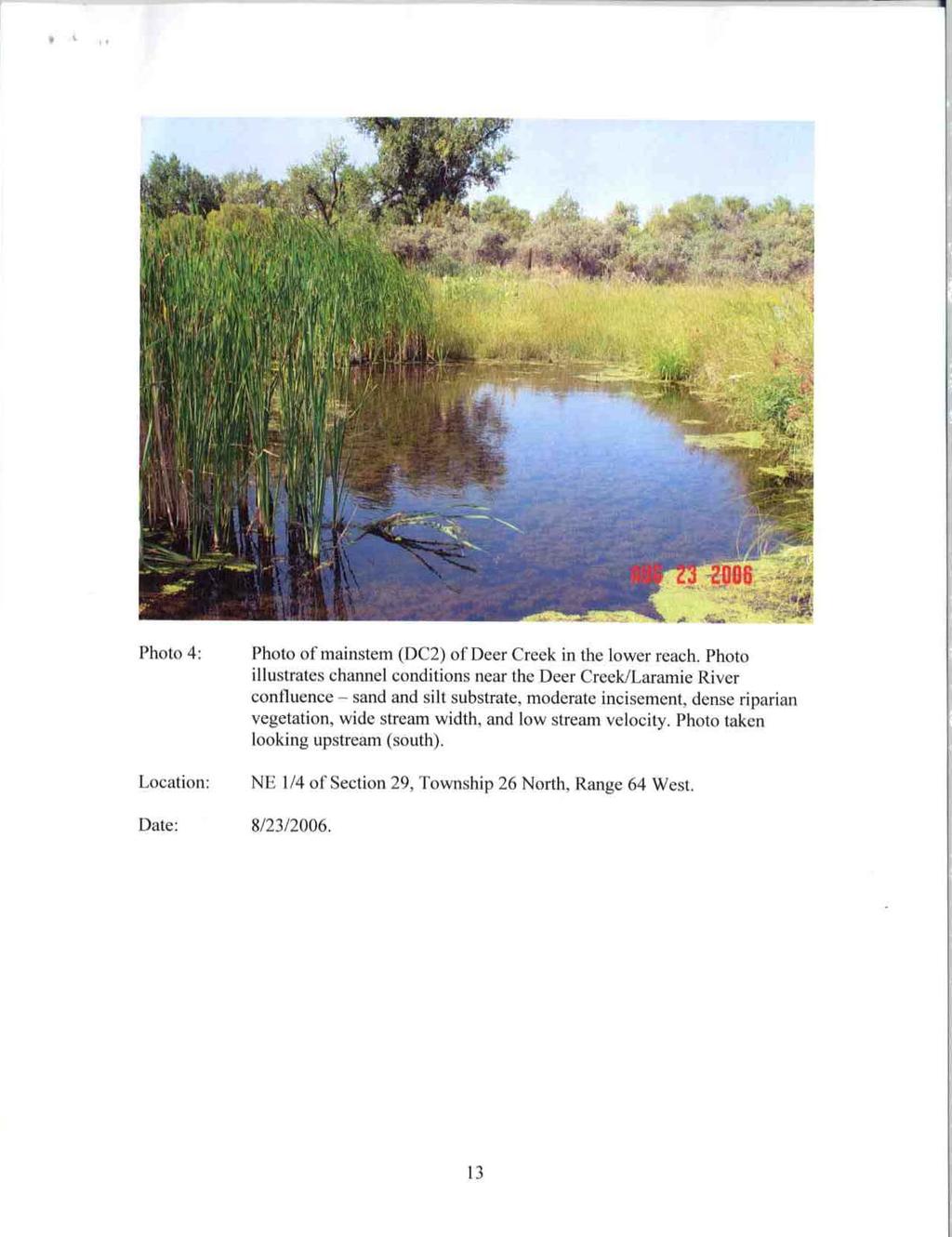
13 13
14 14
15 15
16 16
17 17
18 18
19 19
20 20
21 21
22 22
23 23
24 24
25 25
26 26
27 Appendix B Wyoming Game and Fish Department Letter of Support 27
28 28
29 29
30 30
Proposed Reclassification of Cherry Creek, North Platte River Basin, Wyoming. October 25, 2010
 Proposed Reclassification of Cherry Creek, North Platte River Basin, Wyoming October 25, 2010 Waterbody: Location: Tributary to: Cherry Creek - Mainstem from headwaters downstream to the confluence with
Proposed Reclassification of Horse Creek, North Platte River Basin in Goshen County, Wyoming
 Proposed Reclassification of Horse Creek, North Platte River Basin in Goshen County, Wyoming October 25, 2010 Waterbody: Location: Tributary to: Horse Creek - Mainstem from the confluence with Stinking
Proposed Reclassification of Muskrat Creek, North Platte River Basin in Goshen County, Wyoming
 Proposed Reclassification of Muskrat Creek, North Platte River Basin in Goshen County, Wyoming October 25, 2010 Waterbody: Muskrat Creek - Mainstem of Muskrat Creek from its headwaters downstream to its
Department of Environmental Quality
 Department of Environmental Quality To protect, conserve, and enhance the Quality of Wyoming s environment for the benefit of current and future generations Dave Freudenthal, Governor John Corra, Director
Thunder Bay River Assessment Appendix. Appendix 2
 Appendix 2 Known past and present fish distributions in the River system. Distribution of fishes were compiled from Bailey et al. (2003) and from records located at the Michigan Department of Natural Resources
Alberta Conservation Association 2017/18 Project Summary Report
 Alberta Conservation Association 2017/18 Project Summary Report Project Name: Abundance, Distribution, Spawning, and Thermal Habitat of Westslope Cutthroat Trout and Bull Trout in the Stimson Creek Watershed
Columbia Lake Dam Removal Project
 Columbia Lake Dam Removal Project The Columbia Lake dam located 1/4 mile upstream of the Paulins Kill River's confluence with the Delaware River in Knowlton Township, Warren County has been proposed for
Name That Fish : Identify living things using an existing classification key, and explain the rationale used.
 Outcome: 6-1-04: Identify living things using an existing classification key, and explain the rationale used. Materials: writing utensil Teacher Instructions: 1. Make a class set of pages 2-4. 2. Instruct
Tahquamenon River Assessment Appendix
 DNR DEPARTMENT OF NATURAL RESOURCES MICHIGAN STATE OF MICHIGAN DEPARTMENT OF NATURAL RESOURCES SR45 Appendix February 2008 Tahquamenon River Assessment Appendix James R. Waybrant and Troy G. Zorn www.michigan.gov/dnr/
HURON RIVER WATERSHED
 Brown bullhead (Ameiurus nebulosus) feeding - larger streams and rivers, lakes and impoundments - clear cool water with little clayey silt - moderate amounts of aquatic vegetation - sand, gravel, or muck
Conewago Creek Initiative
 Conewago Creek Initiative The Conewago Creek Revisited Fish Survey Report A compilation of historic fish survey data from 197, 1973, 7, 1, and 15 for three locations along the Conewago Creek Prepared by
Conewago Creek Initiative. Fish Survey Report for the Conewago Creek
 Conewago Creek Initiative Fish Survey Report for the Conewago Creek A compilation of historic fish survey data from 97, 973, 7, for three locations along the Conewago Creek Prepared by Kristen Kyler for
Lower Dolores River Corridor Planning Meeting Jim White Colorado Division of Wildlife
 Lower Dolores River Corridor Planning Meeting Jim White Colorado Division of Wildlife Objectives Overview of cold and warm water fishes in the Dolores River including: Flow and Fish Management Distribution
feeding - clear moderate-sized shallow streams with moderate vegetation spawning - nests in gravel, sand, or hard rock substrate
 orthern longear sunfish (Lepomis peltastes) feeding - clear moderate-sized shallow streams with moderate vegetation - rocky substrates - little to no current spawning - nests in gravel, sand, or hard rock
Swift Current Creek Watershed
 Swift Current Creek Watershed Watershed Boundary Gross drainage area 3939 km 2 973,343 acres Gross creek length 230 km 143 miles Primary water source for 20 000 people Major source of water base recreation
Minnesota Department of Natural Resources Division of Fish and Wildlife Section of Fisheries. Stream Survey Report. Three Mile Creek 2011
 Minnesota Department of Natural Resources Division of Fish and Wildlife Section of Fisheries Stream Survey Report Three Mile Creek 2011 By Joseph D. Stewig Montrose Area Fisheries Office TABLE OF CONTENTS
Trip Report: Eagle Creek, Arizona
 Trip Report: Eagle Creek, Arizona 15-17 June 2009 Participants: Abraham Karam, Brian Kesner, and Mike Childs Native Fish Lab Marsh & Associates, LLC 5016 South Ash Avenue Suite 108 Tempe, Arizona 85282
6TH PELLETIER BROOK LAKE T15 R9, Aroostook Co. U.S.G.S. Gardner Pond, Maine (7 1/2 )
") 6TH PELLETIER BROOK LAKE T15 R9, Aroostook Co. U.S.G.S. Gardner Pond, Maine (7 1/2 ) Fishes Brook trout Minnows Blacknose dace Pearl dace Physical Characteristics Area - 27 acres Average depth - 2 feet
6TH PELLETIER BROOK LAKE T15 R9, Aroostook Co. U.S.G.S. Gardner Pond, Maine (7 1/2 ) Fishes Brook trout Minnows Blacknose dace Pearl dace Physical Characteristics Area - 27 acres Average depth - 2 feet
SUMMARY REPORT FOR LAKE ST. MALO FISHERIES ASSESSMENT. Prepared for the St. Malo and District Wildlife Association
 SUMMARY REPORT FOR LAKE ST. MALO FISHERIES ASSESSMENT Prepared for the St. Malo and District Wildlife Association Presented by August 25, 2014 Study dates thus far: Date Tasks February 16 Fishing derby;
STUDY PERFORMANCE REPORT
 STUDY PERFORMANCE REPORT State: Michigan Project No.: F-81-R-6 Study No.: 230695 Title: Northern Lake Huron, coolwater fish community assessment. Period Covered: October 1, 2004 to September 30, 2005 Study
FISHES OF THE KNIFE LAKE WATERSHED IN KANABEC AND MILLE LACS COUNTIES OF MINNESOTA. Konrad Schmidt, Vice-President
 Conservation Biology Research Grants Program Division of Ecological Services Minnesota Department of Natural Resources FISHES OF THE KNIFE LAKE WATERSHED IN KANABEC AND MILLE LACS COUNTIES OF MINNESOTA
ASSESSMENT OF WHITE PERCH IN LAKE WINNIPESAUKEE, TUFTONBORO (2016) Anadromous and Inland Fisheries Operational Management Investigations
 Anadromous and Inland Fisheries Operational Management Investigations") ASSESSMENT OF WHITE PERCH IN LAKE WINNIPESAUKEE, TUFTONBORO (2016) STATE: GRANT: GRANT TITLE: JOB 9: New Hampshire F-50-R-33 Anadromous and Inland Fisheries Operational Management Investigations Warmwater
ASSESSMENT OF WHITE PERCH IN LAKE WINNIPESAUKEE, TUFTONBORO (2016) STATE: GRANT: GRANT TITLE: JOB 9: New Hampshire F-50-R-33 Anadromous and Inland Fisheries Operational Management Investigations Warmwater
NEVADA DEPARTMENT OF WILDLIFE STATEWIDE FISHERIES MANAGEMENT
 NEVADA DEPARTMENT OF WILDLIFE STATEWIDE FISHERIES MANAGEMENT FEDERAL AID JOB PROGRESS REPORTS F-20-52 2016 EAST FORK AND MAIN STEM CARSON RIVER WESTERN REGION NEVADA DEPARTMENT OF WILDLIFE, FISHERIES DIVISION
Report prepared for: Prepared by: January 2002 BEAK Ref
 AQUATIC ENVIRONMENTAL STUDY KANATA WEST CONCEPT PLAN Report prepared for: ROBINSON CONSULTANTS Prepared by: BEAK INTERNATIONAL INCORPORATED 14 Abacus Road Brampton, Ontario L6T 5B7 January 2002 BEAK Ref.
Tittabawassee River Assessment. Miles. Gladwin Smallwood Impoundment. Harrison. Clare. Midland. Mt. Pleasant. St. Louis. Saginaw.
 Warmouth Lepomis gulosus feeding - clear lakes and impoundments and very low-gradient streams - abundant aquatic vegetation - silt-free water - mucky substrate often covered with organic debris spawning
Appendix L Fish Habitat Assemblage Data
 Appendix L Fish Habitat Assemblage Data Appendix L Fish Habitat Assemblage Data Introduction The following section details the native and nonnative fish assemblages and instream aquatic habitat types
EVALUATION OF THE FISH COMMUNITY AND GAME FISH POPULATIONS IN SUGAR CREEK (MONTGOMERY AND PARKE COUNTIES)
") EVALUATION OF THE FISH COMMUNITY AND GAME FISH POPULATIONS IN SUGAR CREEK (MONTGOMERY AND PARKE COUNTIES) 2000 Fish Management Report Douglas C. Keller Fisheries Biologist FISHERIES SECTION INDIANA DEPARTMENT
EVALUATION OF THE FISH COMMUNITY AND GAME FISH POPULATIONS IN SUGAR CREEK (MONTGOMERY AND PARKE COUNTIES) 2000 Fish Management Report Douglas C. Keller Fisheries Biologist FISHERIES SECTION INDIANA DEPARTMENT
Appendix 2. Miscellaneous Historical Creel Data. References
 Appendix 2 Miscellaneous Historical Creel Data This appendix contains miscellaneous creel data from 1928-1964 for the Kalamazoo River and tributaries. Angler hours, catch by species, total catch, catch
Indiana Administrative Code Page IAC Aquaculture permit Authority: IC Affected: IC Sec. 17. (a) A person must not
 A person must not") Indiana Administrative Code Page 71 312 IAC 9-10-17 Aquaculture permit Affected: IC 14-22-27 Sec. 17. (a) A person must not import, raise, sell, or transport fish into or within Indiana without an aquaculture
Indiana Administrative Code Page 71 312 IAC 9-10-17 Aquaculture permit Affected: IC 14-22-27 Sec. 17. (a) A person must not import, raise, sell, or transport fish into or within Indiana without an aquaculture
Review of Fish and Fish Habitat Information from the Bearberry Creek Drainage. Alberta Conservation Association Activity Report.
 Review of Fish and Fish Habitat Information from the Bearberry Creek Drainage. Alberta Conservation Kevin Fitzsimmons 1 2005 1 Alberta Conservation Association, Box 1420, Cochrane, Alberta, Canada, T4C
Water Habitat Model. Outcome: Materials: Teacher Instructions: : Identify the components of an animal habitat..
 Water Habitat Model Outcome: 4-1-03: Identify the components of an animal habitat.. Materials: Shoe boxes (1 per student) Art supplies: Glue and/or tape Paint and brushes for the background Plasticine/clay
First Nations Fish Habitat Program Discussion Workbook
 First Nations Fish Habitat Program Discussion Workbook The First Nations Fish Habitat Program is a joint initiative of the Centre for Indigenous Environmental Resources (CIER) and The Southern Chiefs Organization
EXECUTIVE SUMMARY. Manistique River Assessment
 EXECUTIVE SUMMARY This is one in a series of River Assessments being prepared by the Michigan Department of Natural Resources, Fisheries Division for Michigan rivers. This report describes the physical
Michigan Department of Natural Resources Status of the Fishery Resource Report Page 1
 Michigan Department of Natural Resources 2008-59 Status of the Fishery Resource Report Page 1 Bowens Manistee County, (T24N R16W Sec. 11, 12, 13, 14, 15, 24, and 30). Last surveyed 2008 Mark A. Tonello
BA1 BA2 BA3 BA4 BA5 BA6 CP1 CP2 CP3 CP4 CP5 CP6
 Table 1: Results of fish collections within or adjacent to the Boyne Secondary Plan Area conducted by C. Portt and Associates. Station locations are provided in Figure 1. Stations BA1-BA6 were collected
Full Project Proposal
 PROJECT NAME: FIELD OFFICE: Full Project Proposal NFPP Phase I - Ferson-Otter Creek Dam Removal/Modification Project, Fox River Watershed, Illinois Carterville NFWCO PROJECT COORDINATOR: Nate Caswell FONS
EXECUTIVE SUMMARY. Muskegon River Watershed Assessment
 EXECUTIVE SUMMARY This assessment for the Muskegon River watershed is one of a series being prepared by Michigan Department of Natural Resources, Fisheries Division, for river basins in Michigan. This
Lake St. Clair Fish Community and Fishery
 Lake St. Clair Fish Community and Fishery Megan Belore Ontario Ministry of Natural Resources and Forestry Mike Thomas Michigan Department of Natural Resources Fish Community Fish Community Mixture of warm
Columbia Lake Dam Removal Project
 Columbia Lake Dam Removal Project Major Goals of the Columbia Lake Dam Removal: Reconnect 10 miles of the Paulins Kill River to the Delaware River, restoring natural flow regime and sediment transport.
GRANT F-48-R. Investigations and Management of New Jersey s Freshwater Fisheries Resources FINAL REPORT JOB I-5
 GRANT F-48-R Investigations and Management of New Jersey s Freshwater Fisheries Resources FINAL REPORT JOB I-5 American Shad Restoration in the Raritan River January 2013 New Jersey Department of Environmental
LAKE SURVEY REPORT DRAFT VERSION PRELIMINARY DATA (AS OF 08/24/2018) Fisheries Management. DOW Number: Survey ID Date: 08/21/2018
 Fisheries Management. DOW Number: Survey ID Date: 08/21/2018") Fisheries Management DRAFT VERSION PRELIMINARY DATA (AS OF 8//8) Lake Name: Sisseton Survey Type: Standard Survey DOW Number: 6-- Survey ID Date: 8//8 Lake Identification Alternate Lake Name: Primary Lake
Fisheries Management DRAFT VERSION PRELIMINARY DATA (AS OF 8//8) Lake Name: Sisseton Survey Type: Standard Survey DOW Number: 6-- Survey ID Date: 8//8 Lake Identification Alternate Lake Name: Primary Lake
COLUMBIA LAKE DAM REMOVAL PROJECT
 COLUMBIA LAKE DAM REMOVAL PROJECT Major Goals of the Columbia Lake Dam Removal: Reconnect 10 miles of the Paulins Kill River to the Delaware River, restoring natural flow regime and sediment transport.
MINNESOTA DEPARTMENT OF NATURAL RESOURCES DIVISION OF FISHERIES AND WILDLIFE. Gamefish Assessment Report
 Minnesota DNR F-29-R(P) Area F312 February 1, 2013 MINNESOTA DEPARTMENT OF NATURAL RESOURCES DIVISION OF FISHERIES AND WILDLIFE Gamefish Assessment Report Spring Gamefish Assessment on the Mississippi
4.14 Aquatic Life and Essential Fish Habitat
 Alternative D Alternative D would have virtually identical impacts on WHPAs as discussed for Alternative A. The Alternative D footprint overlaps no private wells and is within 150 feet of 18 private wells.
NEVADA DEPARTMENT OF WILDLIFE STATEWIDE FISHERIES MANAGEMENT
 NEVADA DEPARTMENT OF WILDLIFE STATEWIDE FISHERIES MANAGEMENT FEDERAL AID JOB PROGRESS REPORTS F-20-52 2016 LAKE TAHOE WESTERN REGION NEVADA DEPARTMENT OF WILDLIFE, FISHERIES DIVISION ANNUAL PROGRESS REPORT
Chapter 5: Survey Reports
 Manual of Fisheries Survey Methods II: with periodic updates : Survey Reports James C. Schneider and J. W. Merna Suggested citation: Schneider, James C. and J. W. Merna. 2000. Survey reports. in Schneider,
APPENDIX 3. Distribution Maps of Fish Species
 APPENDIX 3 Distribution Maps of Fish Species This appendix contains maps of known past and present fish distributions within the Manistique River watershed. The distributions of fish species were compiled
My Key to Manitoba Fish
 My Key to Manitoba Fish Outcome: 6-1-03: Develop a system to classify common objects or living things into groups and subgroups, and explain the reasoning used in the system s development. Materials: large
MISSISSIPPI LEGISLATURE REGULAR SESSION 2007
 MISSISSIPPI LEGISLATURE REGULAR SESSION 2007 By: Representative Robinson (84th) To: Wildlife, Fisheries and Parks HOUSE BILL NO. 911 (As Sent to Governor) 1 2 3 4 5 6 7 8 9 10 11 12 13 14 15 16 17 18 19
North Park Ranch for Sale North Park Ranch for Sale. Double M Ranch Jackson County, CO
 Double M Ranch Jackson County, CO Professionally Developed Trout Fishery and Recreational Ranch Over 2 miles of trophy fishing on the Michigan River One hour from Steamboat Springs Resort Recreational
Table xxx: Listed and Suspected Impairments for Willow Creek 2010 Reach Impairment Pollutant Impaired Uses
 1. (Fairmont) Watershed Summary Description and Land Use Table xxx: (Fairmont) Watershed Overview Watershed Size 18,331 acres/28.7 sq miles/74.3 sq km Elevation Range 2,615 feet [4,980-7,595] Stream Miles
Minnesota Department of Natural Resources Division of Fish and Wildlife Section of Fisheries. Stream Survey Report. Luxemburg Creek.
 Minnesota F-29-R(P)-24 Area 315 Study 3 March 2016 Minnesota Department of Natural Resources Division of Fish and Wildlife Section of Fisheries Stream Survey Report Luxemburg Creek 2015 Mark Pelham Sauk
Trout Unlimited Comments on the Scope of Environmental Impact Statement for the Constitution Pipeline Project, Docket No. PF12-9
 October 9, 2012 Kimberly D. Bose, Secretary Federal Energy Regulatory Commission 888 First Street, NE, Room 1A Washington, DC 20426 RE: Trout Unlimited Comments on the Scope of Environmental Impact Statement
1.Mill Creek Watershed Summary Description and Land Use
 1.Mill Creek Watershed Summary Description and Land Use Table xxx: Mill Creek Watershed Overview Watershed Size 31,435 acres/49.1 sq miles/ 127.1 sq km Elevation Range 5,594 feet [4,967-10,561] Stream
American Currents Spring 1993 Vol 19 No 1
 -22- PUTTING BACK THE PIECES by Konrad Schmidt, St. Paul, Minnesota The Knife River meanders some 25 miles through small farms and woodlands in east central Minnesota before joining the Snake River near
Executive Summary. Map 1. The Santa Clara River watershed with topography.
 Santa Clara River Steelhead Trout: Assessment and Recovery Opportunities December 2005 Prepared By: Matt Stoecker and Elise Kelley, Ph.D. University of California, Santa Barbara Prepared For: The Santa
Alberta Conservation Association 2009/10 Project Summary Report. Project Name: Crowsnest Drainage Sport Fish Population Assessment Phase 1
 Alberta Conservation Association 2009/10 Project Summary Report Project : Crowsnest Drainage Sport Fish Population Assessment Phase 1 Fisheries Program Manager: Peter Aku Project Leader: Jason Blackburn
Funding Habitat Restoration Projects for Salmon Recovery in the Snake River Region SRFB Grant Round Version: 2/19/16
 2016 SRFB Grant Round Version: 2/19/16 Funding Habitat Restoration Projects for Salmon Recovery in the Snake River Region The Project Funding Process Presented by the Snake River Salmon Recovery Lead Entity
1.Warm Springs Creek (Anaconda) Watershed Description and Land Use
 Watershed Description and Land Use") 1.Warm Springs (Anaconda) Watershed Description and Land Use Table xxx: Warm Springs Watershed Overview Watershed Size 92,288 acres/144.2 sq miles/373.6 sq km Elevation Range 5,781 feet [4,800-10,581]
1.Warm Springs (Anaconda) Watershed Description and Land Use Table xxx: Warm Springs Watershed Overview Watershed Size 92,288 acres/144.2 sq miles/373.6 sq km Elevation Range 5,781 feet [4,800-10,581]
Fish faunal changes in Otsego Lake s Shadow Brook watershed following application of best management practices
 Fish faunal changes in Otsego Lake s Shadow Brook watershed following application of best management practices Ryan J. Reynolds 1, Joseph C. Lydon 2 and John R. Foster 3 Abstract: This study was conducted
STREAM SURVEY File form No..
 scanned for KRIS THE RESOURCES AGENCY OF CALIFORNIA California Department of Fish and Game STREAM SURVEY File form No.. Date: September 4, 1969. NAME: North Fork Schooner Gulch Creek COUNTY: Mendocino.
Amendment to a Biological Assessment/Evaluation completed for the Coon Creek Land Disposal completed December Grand Valley Ranger District
 Amendment to a Biological Assessment/Evaluation completed for the Coon Creek Land Disposal completed December 2007 Grand Valley Ranger District Grand Mesa, Uncompahgre, Gunnison National Forests Prepared
Lake Superior. Ontonagon River Assessment. Ontonagon. Rockland. Victoria Dam. Bergland. Bergland. Dam. Bruce Crossing Agate Falls. Kenton Lower.
 Sand shiner otropis stramineus feeding - sand and gravel substrate - shallow pools in medium size streams, lakes, and impoundments - clear water and low gradient - rooted aquatic vegetation preferred -
WFC 50 California s Wild Vertebrates Jan. 11, Inland Waters (Lakes and Streams) Lisa Thompson
 Lisa Thompson") Inland Waters: Lakes and Streams WFC 50 11 January 2011 Lisa Thompson Fisheries Extension Specialist Wildlife, Fish, & Conservation Biology Department University of California, Davis Take home messages
Inland Waters: Lakes and Streams WFC 50 11 January 2011 Lisa Thompson Fisheries Extension Specialist Wildlife, Fish, & Conservation Biology Department University of California, Davis Take home messages
Flint River Assessment Appendix
 14 Appendix 3 Distribution Maps of Fish Species This appendix contains maps of past and known present fish distributions within the River watershed. The distributions of fish species were compiled from
Project Name: Distribution of Sport Fish in the Waterton River Tailwater, 2014
 Alberta Conservation Association (ACA) Date: 2014-2015 Project Name: Distribution of Sport Fish in the Waterton River Tailwater, 2014 Fisheries Program Manager: Peter Aku Project Leader: Jason Blackburn
Certification Page Regular and Emergency Rules
 Certification Page Regular and Emergency Rules Revised June 2013 Emergency Rules (After completing all of Sections 1 and 2, proceed to Section 5 below) Regular Rules 1. General Information a. Agency/Board
Fisheries Survey of White Rapids Flowage, Marinette County Wisconsin during Waterbody Identification Code
 Fisheries Survey of White Rapids Flowage, Marinette County Wisconsin during 25 Waterbody Identification Code 6343 Michael Donofrio Fisheries Supervisor Wisconsin Department of Natural Resources Peshtigo,
Black crappie (Pomoxis nigromaculatus)
") Black crappie (Pomoxis nigromaculatus) feeding - larger clear non-silty low-gradient rivers; also in lakes and impoundments - clean hard sand or muck substrate - associated with submerged aquatic vegetation
Black crappie (Pomoxis nigromaculatus) feeding - larger clear non-silty low-gradient rivers; also in lakes and impoundments - clean hard sand or muck substrate - associated with submerged aquatic vegetation
Feb 22, Supplemental Reclassification of Streams in the Catawba and Yadkin River Basins to Trout Waters
 Feb 22, 2010 Mr. Jeff Manning Supervisor, Classifications and Standards Unit Division of Water Quality North Carolina Department of Environment and Natural Resources 1617 Mail Service Center Re: Supplemental
5B. Management of invasive species in the Cosumnes and Mokelumne River Basins
 5B. Management of invasive species in the Cosumnes and Mokelumne River Basins Cosumnes River The Cosumnes River basin has a number of distinct habitat types that require different management strategies
Refined Designated Uses for the Chesapeake Bay and Tidal Tributaries
 A-1 appendixa Refined Designated Uses for the Chesapeake Bay and Tidal Tributaries BACKGROUND Federal water quality standards regulations establish that states must specify appropriate water uses to be
Pohatcong Creek - FIBI033
 DELAWARE RIVER Pohatcong Creek - FIBI033 Drainage Area of FIBI033: 9.8 Square Miles Surface Water Quality Classification of FIBI033: FW2-TM Washington #S "! 3 1 % P ohatcong Creek FIBI033 "! 57 Merri l
NEVADA DEPARTMENT OF WILDLIFE STATEWIDE FISHERIES MANAGEMENT
 NEVADA DEPARTMENT OF WILDLIFE STATEWIDE FISHERIES MANAGEMENT FEDERAL AID JOB PROGRESS REPORTS F-20-48 2012 LAKE TAHOE WESTERN REGION Contents NEVADA DEPARTMENT OF WILDLIFE, FISHERIES DIVISION ANNUAL PROGRESS
STEELHEAD SURVEYS IN OMAK CREEK
 STEELHEAD SURVEYS IN OMAK CREEK 2002 Annual Report Prepared by Chris Fisher John Arterburn Colville Confederated Tribes Fish and Wildlife Department P.O. Box 150 Nespelem, WA 99155 Prepared for Project
EXECUTIVE SUMMARY FISH COMMUNITY AND HABITAT EXISTING CONDITIONS REPORT
 EXECUTIVE SUMMARY FISH COMMUNITY AND HABITAT EXISTING CONDITIONS REPORT First Mining Gold (First Mining) has completed a comprehensive Fish Community and Habitat Existing Conditions Report which has utilized
Fisheries Review with Respect to Stormwater Management for Milton/Navan Road Property
 Fax: 613.935.6295 Mr. Jean-Luc Rivard 3223701 CANADA INC. 98 rue Lois Gatineau, QC J8Y 3R7 July 23, 2014 Re.: Fisheries Review with Respect to Stormwater Management for Milton/Navan Road Property Mr. Rivard:
DOWNLOAD OR READ : TROUT STREAMS OF WESTERN NEW YORK PDF EBOOK EPUB MOBI
 DOWNLOAD OR READ : TROUT STREAMS OF WESTERN NEW YORK PDF EBOOK EPUB MOBI Page 1 Page 2 trout streams of western new york trout streams of western pdf trout streams of western new york Interior Redband
ADOPT-A-STREAM WATERSHED APPROACH COMMUNITY-BASED STEWARDSHIP. Nova Scotia Salmon Association March 2005
 ADOPT-A-STREAM A WATERSHED APPROACH TO COMMUNITY-BASED STEWARDSHIP Nova Scotia Salmon Association March 2005 This manual is a revised and updated version of the 1994 Adopt-a-Stream manual that was prepared
Fish Community. Fish Habitat, Streams and Rivers
 Clear, Ston(e)y and White Lake Plan Fish Community The lakes support a cool/warm water fishery including muskellunge, walleye, largemouth and smallmouth bass, yellow perch, pumpkinseed, rockbass, blue
Target Fish Communities and the MA Water Policy
 Target Fish Communities and the MA Water Policy Todd Richards MA Division of Fisheries and Wildlife Todd.Richards@state.ma.us MA Water Policy (2004) Principle: Protect Fish and Wildlife Habitat Recommendation:
BIG TWIN LAKE Kalkaska County (T28N, R05W, Section 18, and T28N, R06W, Section 13) Surveyed May 1999
 Surveyed May 1999") Michigan Department of Natural Resources Status of the Fishery Resource Report No. 2001-1, Year 2001 BIG TWIN LAKE Kalkaska County (T28N, R05W, Section 18, and T28N, R06W, Section 13) Surveyed May 1999
Michigan Department of Natural Resources Status of the Fishery Resource Report No. 2001-1, Year 2001 BIG TWIN LAKE Kalkaska County (T28N, R05W, Section 18, and T28N, R06W, Section 13) Surveyed May 1999
Bode Lake - South Population Survey
 Bode Lake - South Survey Located in Hoffman Estates on the north side of Bode Rd. 1 mile west of Barrington Rd. Bode Lake is made up of two lakes along Poplar Creek; the larger and deeper Bode Lake South
LAKE DIANE Hillsdale County (T8-9S, R3W, Sections 34, 3, 4) Surveyed May Jeffrey J. Braunscheidel
 Surveyed May Jeffrey J. Braunscheidel") Michigan Department of Natural Resources Status of the Fishery Resource Report No. 2003-4, 2003 LAKE DIANE Hillsdale County (T8-9S, R3W, Sections 34, 3, 4) Surveyed May 2001 Jeffrey J. Braunscheidel Environment
Michigan Department of Natural Resources Status of the Fishery Resource Report No. 2003-4, 2003 LAKE DIANE Hillsdale County (T8-9S, R3W, Sections 34, 3, 4) Surveyed May 2001 Jeffrey J. Braunscheidel Environment
Quemahoning Reservoir
 Pennsylvania Fish & Boat Commission Biologist Report Quemahoning Reservoir Somerset County May 2011 Trap Net, Gill Net and Electrofishing Survey Quemahoning Reservoir is an 899 acre impoundment located
WYOMING GAME AND FISH DEPARTMENT
 1 March 1, 2013 WYOMING GAME AND FISH DEPARTMENT 5400 Bishop Blvd. Cheyenne, WY 82006 Phone: (307) 777-4600 Fax: (307) 777-4699 wgfd.wyo.gov GOVERNOR MATTHEW H. MEAD DIRECTOR SCOTT TALBOTT COMMISSIONERS
Ontonagon River Assessment
 Urban/Industrial.1% Open water 4.5% Wetland 15.% Barren.6% Agriculture 5.4% Grassland.2% Forest 74.2% Figure 19. Percent land use in the Ontonagon River watershed. Michigan data from Michigan 1992 NLCD
feeding - downstream sections of large rivers, lakes, and impoundments
 River Assessment Appendix Shorthead redhorse (Moxostoma macrolepidotum) feeding - downstream sections of large rivers, lakes, and impoundments - rocky substrates - swift water near riffles - clear to slightly
REC 6 FISHERIES HABITAT EVALUATION
 REC 6 FISHERIES HABITAT EVALUATION 1.0 EXECUTIVE SUMMARY Analysis of fisheries habitat for recreational angling opportunities was completed by reviewing the results of the CAWG 1, Characterize Stream and
NEVADA DEPARTMENT OF WILDLIFE STATEWIDE FISHERIES MANAGEMENT FEDERAL AID JOB PROGRESS REPORTS F LAHONTAN CUTTHROAT TROUT EASTERN REGION
 NEVADA DEPARTMENT OF WILDLIFE STATEWIDE FISHERIES MANAGEMENT FEDERAL AID JOB PROGRESS REPORTS F-20-50 2014 LAHONTAN CUTTHROAT TROUT EASTERN REGION NEVADA DEPARTMENT OF WILDLIFE, FISHERIES DIVISION ANNUAL
STUDY PERFORMANCE REPORT
 STUDY PERFORMANCE REPORT State: Michigan Project No.: F-81-R-5 Study No.: 230466 Title: Fish community status in Saginaw Bay, Lake Huron Period Covered: October 1, 2003 to September 30, 2004 Study Objective:
Environmental Review and Permitting for Wild Trout
 Environmental Review and Permitting for Wild Trout Tom Shervinskie Wild Trout Summit Watershed Analysis Section August 26, 2017 Division of Environmental Services The mission of the Pennsylvania Fish and
Preakness Brook - FIBI098
 Preakness Brook - FIBI098 Preakn ess B rook Preakness " ( FIBI098 Naachtpunkt Brook 202 80 IBI Ratings FIBI Sampling Location Excellent Small Streams (1st and 2nd Order) Good Fair Large Streams (3rd Order
Habitat Hideout. Chapter 1 Lesson 5
 Chapter 1 Lesson 5 Habitat Hideout Living in the fast lane can be exciting, but it takes a lot of energy. Fish seek places where they can rest, find food, and evade predators. 1:5-B Chapter 1 Lesson 5
Study Update Tailrace Slough Use by Anadromous Salmonids
 Study Update Tailrace Slough Use by Anadromous Salmonids Goals and Objectives Identify what anadromous salmonids use the tailrace slough by: Life Stage (Juvenile, migrating and spawning adults) Timing
NEVADA DEPARTMENT OF WILDLIFE STATEWIDE FISHERIES MANAGEMENT
 NEVADA DEPARTMENT OF WILDLIFE STATEWIDE FISHERIES MANAGEMENT FEDERAL AID JOB PROGRESS REPORTS F-20-49 2013 LAKE TAHOE WESTERN REGION NEVADA DEPARTMENT OF WILDLIFE, FISHERIES DIVISION ANNUAL PROGRESS REPORT
Investigating reproduction and abundance of bighead carp (Hypophthalmichthys nobilis) and silver carp (H. molitrix) in the Greenup pool, Ohio River
 and silver carp (H. molitrix) in the Greenup pool, Ohio River") Investigating reproduction and abundance of bighead carp (Hypophthalmichthys nobilis) and silver carp (H. molitrix) in the Greenup pool, Ohio River Nathan Fleshman Dr. Thomas Jones Photo: USGS Photo: USGS
Investigating reproduction and abundance of bighead carp (Hypophthalmichthys nobilis) and silver carp (H. molitrix) in the Greenup pool, Ohio River Nathan Fleshman Dr. Thomas Jones Photo: USGS Photo: USGS
Fish Survey of Arctic Lake (ID # ), Scott County, Minnesota in 2012
, Scott County, Minnesota in 2012") Snapping Turtle from Arctic Lake, September 2012 Fish Survey of Arctic Lake (ID #70-0085), Scott County, Minnesota in 2012 Survey Dates: September 18-20, 2012 MnDNR Permit Number: 18362 Prepared for: Shakopee
Snapping Turtle from Arctic Lake, September 2012 Fish Survey of Arctic Lake (ID #70-0085), Scott County, Minnesota in 2012 Survey Dates: September 18-20, 2012 MnDNR Permit Number: 18362 Prepared for: Shakopee
DOLORES RIVER NATIVE FISH HABITAT RECOMMENDATIONS AND ALTERNATIVES TO WILD AND SCENIC DESIGNATION
 DOLORES RIVER NATIVE FISH HABITAT RECOMMENDATIONS AND ALTERNATIVES TO WILD AND SCENIC DESIGNATION Prepared by: Colorado Department of Natural Resources Southwest Aquatic Section-DOW Southwest Wildlife
Advancing Fish Passage in the Menomonee River Watershed
 University of Massachusetts - Amherst ScholarWorks@UMass Amherst International Conference on Engineering and Ecohydrology for Fish Passage International Conference on Engineering and Ecohydrology for Fish