Twinning Hwy 11/17 Thunder Bay to Nipigon
|
|
|
- Ira Owen
- 5 years ago
- Views:
Transcription
1 Twinning Hwy 11/17 Thunder Bay to Nipigon 55 th Annual Engineering and Technology Conference Lakehead Chapter PEO November 4, 2016 Presented by: Bruce Caldwell, P. Eng., MBA Manager Program Planning Ministry of Transportation 1
2 Outline History Decision to Four-laning Highway 11/17 Present Day Status and Highlights Challenges Benefits 2

3 History of Highway 11/17 Highway 11/17 between Thunder Bay and Nipigon forms a strategic link in the Trans-Canada Highway System. Trans-continental, regional and local traffic rely heavily on this 100 km section of highway. There is no alternate route in the Province, connecting eastern Canada to western Canada.

4 History of Highway 11/17 Road between Nipigon and Port Arthur/Fort William was completed in Nipigon River Bridge on Highway 17 was officially opened on Sept. 24, Highway 11 between Nipigon and Geraldton was officially opened on Sept. 7, Highway 17 linked to Sault Ste. Marie in 1961.

5 History of Highway 11/

6 Four-laning Highway 11/17 Closure of the Trans- Canada system would have an immediate impact on the economy of the region as well as the trans-continental movement of goods and people in Canada. The potential risk of such a closure was first brought to light in the early 1970s when a load limit was placed on the original Nipigon River bridge. Between Mackenzie and Birch Beach

7 Four-laning Highway 11/17 Since then, MTO has identified the potential risk of closure at a number of bridge sites along this section of Highway 11/17. During the 1970s & 1980s, the public expressed the need to four-lane Highway 11/17 between Nipigon & Shabaqua, due to the absence of an alternate route when weather, collisions and construction caused closure of the route. Crystal Beach
8 Four-laning Highway 11/17 In late 1989, the government announced an accelerated program for highway improvements in northern Ontario. This included the four-laning of Highway 11/17 between Thunder Bay and Nipigon. With this announcement, commitments were made to identify a four-lane corridor and five separate studies were undertaken between: Balsam Street and Highway 527 Highway 527 and Mackenzie Station Road Mackenzie Station Road and Welch Creek Welch Creek and the Township of Red Rock west boundary The Township of Red Rock west boundary and the junction of Highways 11 and 17 (Nipigon)
9 Four-laning Highway 11/17 These studies were carried out in accordance with the Provincial Highways Class Environmental Assessment. Extensive public consultation was under taken As many as four Public Information Centres were held for each project In 1993 construction of four-lanes between Balsam St. and Hodder Ave. began.
10 Four-laning Highway 11/17 In 1994, four-laning was deemed premature, following a reassessment of costs and priorities. In 1996 planning studies were completed to the point of being able to designate and protect the right-of-way for future four-laning. Designation occurred in Over the years the MTO continued to make improvements to the existing highway including adding turning lanes and building passing and truck climbing lanes. Interest in four-laning was renewed in early 2000 s, and in May 2009 the Ontario Government committed to the construction of two projects, commencing in 2010.
11 Ministry of Transportation
12 TIME PASSES 12
13 TIME PASSES PRESENT DAY 13
14 14
15 What s Finished? Completed (30.2 km): Hodder Avenue easterly to Highway 527 (3.8 km), including a full interchange at Hodder and realignment to the Terry Fox Rest Area. This project was completed in fall [ ] Mackenzie Station Road to Birch Beach Road (13.4 km-new alignment), including new bridges over the Mackenzie River. This project opened to traffic in summer [ ] Highway 527 to Mackenzie Station Road (13km). This project opened to traffic in the fall [ ] 15


16 Mackenzie River Bridges Mackenzie River Fall 2010

17 2013 Ontario Concrete Awards Ministry of Transportation Two Awards for the Hodder Interchange: Material Development & Innovation Precast Concrete Structural Design Innovation Precast Concrete 17
18 18
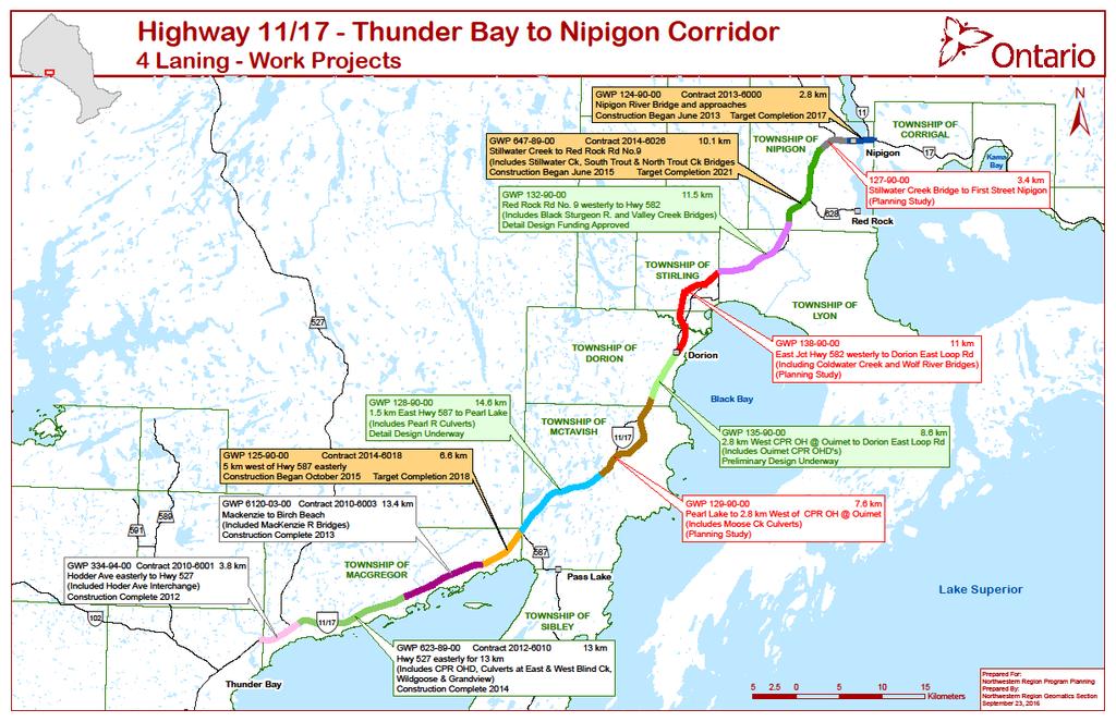
19 What s Under Construction? Construction Underway (19.5 km): Nipigon River Bridge and approaches from First Street to Highway 11/Highway 17 intersection (2.8 km) (Construction started in summer 2013). [ ] Red Rock Road No. 9 to Stillwater Creek Bridge (10.1 km) (Utility Relocations started in 2013, construction started in 2015). [ ] Birch Beach Road to Highway 587 at Pass Lake (6.6 km) Design-Build (Construction started in 2015). [ ] 19

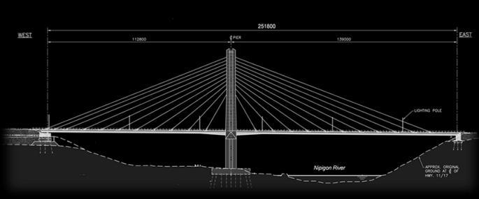
20 Nipigon River Bridge 20

21 Ministry of Transportation Nipigon Bridge Failure Jan 10, 2016 Provincial Management October 29, Highways
22 Nipigon Bridge Failure Full information about the Nipigon River Bridge failure and the subsequent investigation reports can be found at: 22

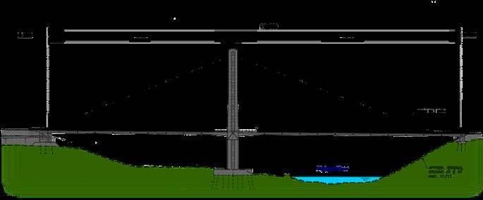
23 Nipigon Bridge Original Design Ministry of Transportation 23

24 Nipigon Bridge Immediate Fix Jan 11,

25 Nipigon Bridge Temporary Repair Feb 19 25

26 Nipigon Bridge Permanent Retrofit Ministry of Transportation 26

27 Nipigon Bridge Looking Downstream 27

28 Nipigon Bridge Looking Eastwards Ministry of Transportation 28

29 Nipigon Bridge Drone s Eye View Ministry of Transportation 29
30 30
31 What s in Design? Design Underway (34.7 km): Highway 587 to Pearl Creek (14.6 km) (Construction expected to start in 2018*). [ ] Red Rock Road No. 9 westerly to Hwy 582 (11.5 km) including Black Sturgeon River and Valley Creek Bridges. (Construction expected to start in 2018*). [ ] CPR Overhead at Ouimet to Dorion East Loop (8.6 km), including new bridges for the CPR overhead on new alignment (Construction expected to start in 2018*). [ ] * The timing of projects in this list is subject to change based on funding, planning, design, environmental approval, property acquisition and construction requirements 31


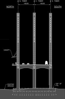
32 Ouimet CPR Overpass Note concept sketches are from Planning and Preliminary Design Study, and are subject to refinement during value engineering analysis and detailed design. 32
33 33
34 What s Left? Planning Study (22 km): Pearl to Ouimet (7.6 km) (Construction expected to start in 2020*). [ ] Dorion to Hwy 582 (11 km) (Construction expected to start in 2020*). [ ] Stillwater Creek Bridge to First Street Nipigon (3.4 km) (Construction expected to start in 2020*). [ ] * The timing of projects in this list is subject to change based on funding, planning, design, environmental approval, property acquisition and construction requirements 34

35 Challenges Utilities Major Hydro Transmission towers parallel the existing highway throughout Many steel towers require relocation with significant costs Property Property acquisition can take up to 18 months Fisheries Sensitive fish habitat is present throughout Highway 11/17 - Fall 2010

36 Challenges Foundations Swamps Long Preload Settlement Times Rock Cuts Rock Blasting at Pearl Lake


37 Challenges Archaeology Significant Paleo Indian site was discovered near the banks of the Mackenzie River. This site is considered rare and complex.


38 Challenges Artifacts are estimated to be between 7000 and 9000 years old. Significant quantities of all tool types have been found. Salvage of archaeological artifacts is a requirement of the Ontario Heritage Act.
39 Benefits Four-laning continues to: Improve driver comfort and safety Eliminate head-on collisions Provide a parallel road that will serve as an emergency alternate route in the event of a natural disaster or structural loss Generate construction jobs Support economic growth in Northern Ontario
40 Questions?
Trans-Canada Highway 1 RW Bruhn Bridge Replacement
 Trans-Canada Highway 1 RW Bruhn Bridge Replacement May 2016 RW Bruhn Bridge Project Objectives Improve safety, traffic flow and movement of goods Improve safety for pedestrians and cyclists Replace the
Welcome to the McKenzie Interchange Project Open House!
 Welcome to the McKenzie Interchange Project Open House! Purpose of Open House To provide you with information regarding the project and for you to have the opportunity to share your input on design concepts.
WELCOME TO OPEN HOUSE # 1 June 14, 2017
 Langstaff Road Weston Road to Highway 7 Class Environmental Assessment Study WELCOME TO OPEN HOUSE # 1 June 14, 2017 Please sign in and join our mailing list Purpose of Open House #1 & Study Area York
Design Criteria. Design Criteria
 F Design Criteria Design Criteria Ministry of Transportation Ministère des Transports DESIGN CRITERIA Page: 1 of 13 WORK PROJECT NO. N/A GO Bloomington Station TYPE OF PROJECT LOCATION Bloomington Road
Rebuilding Highway 7 Town Centre Boulevard to Sciberras Road
 Rebuilding Highway 7 Town Centre Boulevard to Sciberras Road Project Status Update Presentation to City of Markham Development Services Committee October 22, 2013 Presentation Outline Background Status
List of Display Boards
 List of Display Boards Welcome Introduction Municipal Class Environmental Assessment (EA) Process Need and Justification for an Interchange Alternatives for Evaluation Vertical and Horizontal Alignments
McKenzie Interchange Project Fall 2015 Engagement. Appendix 2: Engagement Materials and Feedback Form
 Fall 2015 Engagement Appendix 2: Engagement Materials and Feedback Form Welcome to the McKenzie Interchange Project Open House! Purpose of Open House To provide you with information regarding the project
Transportation Master Plan Advisory Task Force
 Transportation Master Plan Advisory Task Force Network Alternatives & Phasing Strategy February 2016 BACKGROUND Table of Contents BACKGROUND Purpose & Introduction 2 Linking the TMP to Key Council Approved
Highway 1 Kamloops to Alberta Four-Laning Program
 Highway 1 Kamloops to Alberta Four-Laning Program COMMUNITY ENGAGEMENT DISCUSSION GUIDE AND FEEDBACK FORM February 7 March 1, 2013 www.bchwy1.ca 1 FEEDBACK FORM INSIDE HOW INPUT WILL BE CONSIDERED FAST
Changes to Traffic Circulation with Centrerunning
 Changes to Traffic Circulation with Centrerunning BRT A B C A B C At signalized intersections, traffic will be able to cross the BRT lanes and make right or left turns. At unsignalized minor streets and
COUNTY ROAD 22 HORSESHOE VALLEY ROAD. Municipal Class Environmental Assessment. simcoe.ca
 OCTOBER 2014 Municipal Class Environmental Assessment COUNTY ROAD 22 HORSESHOE VALLEY ROAD Project A Truck Climbing Lanes Project B Intersection Improvements simcoe.ca CORPORATE COMMUNICATIONS DEPARTMENT
Alberta Highway 881. Corridor Management Plan. Session Forum 1 - Highways. Tri-Party Transportation Conference Moving Alberta Into the Future
 Tri-Party Transportation Conference Moving Alberta Into the Future Alberta Highway 881 Corridor Management Plan Lac La Biche to Anzac Session Forum 1 - Highways March 2017 INTRODUCTION + 241 km long, 2
APPENDIX 2 LAKESHORE ROAD TRANSPORTATION REVIEW STUDY EXECUTIVE SUMMARY
 APPENDIX 2 LAKESHORE ROAD TRANSPORTATION REVIEW STUDY EXECUTIVE SUMMARY Appendix 2 City of Mississauga Lakeshore Road FINAL REPORT Transportation Review Study December 2010 EXECUTIVE SUMMARY Study Purpose
Iowa Highway 58 Corridor Improvement Study
 1 Iowa Highway 58 Corridor Improvement Study Public Informational Meeting May 6, 2014 2 Welcome and Introductions Randy Lorenzen, City of Cedar Falls Engineer 3 Outline of Presentation Review of Project
WELCOME PTH 59N - PTH 101 INTERCHANGE FUNCTIONAL DESIGN STUDY PUBLIC INFORMATION SESSION MONDAY, JUNE 13, :00 P.M. - 8:00 P.M.
 WELCOME - PTH 1 INTERCHANGE FUNCTIONAL DESIGN STUDY PUBLIC INFORMATION SESSION MONDAY, JUNE 13, 11 4:00 P.M. - 8:00 P.M. PROJECT STUDY AREA 1 Wenzel Street PR 2 Pritchard Farm Farm Road Road McGregor Farm
Casablanca Boulevard & GO Station Access
 Casablanca Boulevard & GO Station Access Class Environmental Assessment STAKEHOLDER WORKSHOP Thursday September 27th, 2018 5:30PM 8:00PM 1 WORKSHOP PURPOSE Provide an overview of the Design Alternatives
Municipal Class EA To Address Traffic Congestion On The Ontario Street Corridor (Grand Bend) Public Information Meeting June 4, 2018
 Public Information Meeting June 4, 2018") Municipal Class EA To Address Traffic Congestion On The Ontario Street Corridor (Grand Bend) Public Information Meeting June 4, 2018 Background Agenda Traffic Study Update Class EA Alternatives Bridge
Municipal Class EA To Address Traffic Congestion On The Ontario Street Corridor (Grand Bend) Public Information Meeting June 4, 2018 Background Agenda Traffic Study Update Class EA Alternatives Bridge
Implementation Report # False Creek Bridges
 Implementation Report #1 2013-04-24 False Creek Bridges ECONOMY PEOPLE ENVIRONMENT Intro Council Requested Report Back Topics Progress on Planning for Broadway Subway False Creek Bridges Local Transit
Decision on North Waterloo Routing
 Next Steps Decision on North Waterloo Routing Two route variations remain in north Waterloo. The final preferred route will include only one of the two variations. Please consider these two variations
McKenzie Interchange Project Spring 2016 Comment Period. Appendix 1: Display Boards and Feedback Form
 McKenzie Interchange Project Spring 2016 Comment Period Appendix 1: Display Boards and Feedback Form August 2016 Welcome to the McKenzie Interchange Project Information Session! Purpose of this Information
WEST AND SOUTH WEST RING ROAD DOWNSTREAM TRAFFIC IMPACTS
 Page 1 of 9 EXECUTIVE SUMMARY Alberta Transportation ( AT ) is preparing to construct the final sections of the Calgary Ring Road. This includes the South West Ring Road ( SWRR ) (from Lott Creek Blvd
FY STATEWIDE TRANSPORTATION IMPROVEMENT PROGRAM New Jersey Department of Transportation Projects
 ROUTE/ Project ID No. TIP No. Electrical Load Center Replacement - North 04324 04324 This project will provide for the betterment of the existing highway lighting facilities located along Routes 3, 17
2. THAT the Mayor and Corporate Officer be authorized to execute all documents related to this matter.
 COUNCIL REPORT Report No. PRC 016-2016 EXECUTIVE COMMITTEE Date: March 2, 2016 File No: 6240-01 To: From: Subject: Mayor and Council Heidi Enns, General Manager, Parks, Recreation and Culture BikeBC Program
B741 TEMPORARY CONCRETE BARRIERS - OPSS 741
 B741 TEMPORARY S - OPSS 741 741.1 GENERAL Temporary concrete barriers (TCBs) are precast units that are installed with interlocking devices connecting consecutive sections. The following types of connections
7th Street Bridge Project. Public Presentation February 24, :30pm-8pm
 7th Street Bridge Project Public Presentation February 24, 2014 6:30pm-8pm Public Meeting Agenda Welcome and introductions Judith Buethe Opening remarks - David Leamon, PE/Hans Strandgaard, PE Project
Welcome to the Open House
 Leslie Street Between 19 th Avenue and Stouffville Road Addendum to Class Environmental Assessment Study Welcome to the Open House Please sign in at the front desk. March 28, 2017 Richmond Green Sports
Peterborough Council on Aging
 Peterborough Council on Aging Discussion paper series #4, 2015 Transportation Transportation, including accessible and affordable public transport is a key factor influencing active aging. in particular,
Mandan Commission Meeting August 2, 2016 Mandan City Hall
 Mandan-Bismarck Corridor Improvement Study Mandan Commission Meeting August 2, 2016 Mandan City Hall 2014 HDR, Inc., all rights reserved. Mandan Corridors Study Schedule 2015 2016 Study Kick Off August
CHAPTER THREE MOBILITY
 CHAPTER THREE MOBILITY 70 MAJOR THOROUGHFARES Operations. The City of Ames is served by a combination of federal, state and local highways/streets that are interlinked in creating a regional and inter-city
Paul Huston, P.E., Design-Build Coordinator Chuck Gonderinger, HDR Engineering. Minnesota Department of Transportation (the Department)
") To: From: Paul Huston, P.E., Design-Build Coordinator Chuck Gonderinger, HDR Engineering Date: March 20, 2001 Subject: Roadway Geometric Design Criteria Project: TH 14/218 Design-Build Project, SP 7408-29,
To: From: Paul Huston, P.E., Design-Build Coordinator Chuck Gonderinger, HDR Engineering Date: March 20, 2001 Subject: Roadway Geometric Design Criteria Project: TH 14/218 Design-Build Project, SP 7408-29,
B741 - TEMPORARY CONCRETE BARRIERS - OPSS 741
 B741 - - OPSS 741 741.1 GENERAL Temporary concrete barrier (TCB) is a portable barrier system consisting of freestanding precast concrete segments that are positively connected together to form a continuous
HIGHWAY 11 CORRIDOR STUDY
 HIGHWAY 11 CORRIDOR STUDY Executive Summary August 2016 Roseau County?æA@?çA@ Warroad Lake of the Woods Roseau Roosevelt Badger?ÄA@ Greenbush Legend N Hwy 11 Study Area Figure 1: Corridor Study Limits
2015 Data review. Capturing Ready Lane NEXUS vehicles
 2015 Data review Capturing Ready Lane NEXUS vehicles Problem: NEXUS users make up the majority of traffic using the Ready Lane, but they are currently considered either standard traffic or Ready Lane traffic.
Chapter 4 Route Window C3 Hyde Park and Park Lane shafts. Transport for London
 Chapter 4 Route Window C3 Hyde Park and Park Lane shafts Transport for London HYDE PARK AND PARK LANE SHAFTS 4 Route Window C3 Hyde Park and Park Lane shafts Introduction 4.1 In this route window, which
CITY OF KINGSTON REPORT TO COUNCIL. Report No.:
 CITY OF KINGSTON REPORT TO COUNCIL Report No.: 13-072 TO: FROM: RESOURCE STAFF: Mayor and Members of Council Jim Keech, President and CEO, Utilities Kingston Mark Van Buren, Director of Engineering DATE
CITY OF SASKATOON COUNCIL POLICY
 ORIGIN/AUTHORITY Clause 1, Report No. 1-1980 and Clause 4, Report No. 22-1990 of the Works and Utilities Committee; Clause 6, Report No. 17-2004 of the Planning and Operations Committee; and Clause D5,
QUEEN ELIZABETH WAY / MARTINDALE ROAD BRIDGE DEMOLITION DETOUR ANALYSIS
 QUEEN ELIZABETH WAY / MARTINDALE ROAD BRIDGE DEMOLITION DETOUR ANALYSIS Fabio Saccon, P.Eng Area Traffic Manager Bernard James Engineer in Training Martin Sneep Senior Project Manager Lance Dutchak Traffic
York Region Population and Employment Growth
 March 1, 2016 1 York Region Population and Employment Growth York Region needs to comply with The Provincial Growth Plan and new forecasts introduced to 2036 and 2041 2 Regional Official Plan Review York
Corridor Studies. LA 415 and LA 73
 Corridor Studies LA 415 and LA 73 Project Approach for Both Corridors 1. Data Collection 2. Data Summary 3. Traffic Analysis 4. Micro-Simulation modeling 5. Generation of alternatives 6. Modeling alternatives
Windsor Regional Construction Traffic Management System
 Author s Identification Mr. Roger Browne, M.A.Sc., P. Eng. Senior Project Engineer - Advanced Traffic Management Section Ministry of Transportation of Ontario 6th Floor, Building D 1201 Wilson Ave Downsview,
County Road 2 Long Sault Improvements EA Study Schedule C Municipal Class Environmental Assessment. Environmental Study Report
 Study Schedule C Municipal Class Environmental Assessment Prepared By: BT Engineering 100 Craig Henry Drive, Suite 201 Ottawa, ON K2G 5W3 (613) 228-4813 (855) 228-4813 Toll free Executive Summary Executive
City of Waterloo Complete Streets Policy
 City of Waterloo Complete Streets Policy Chris Hodgson P. Eng City of Waterloo Complete Streets Forum 2011 April 28-29 Toronto Waterloo context: Current population Major employers Universities and student
Cincinnati Dayton Rd Widening
 Cincinnati Dayton Rd Widening Project Overview Widening of Cincinnati Dayton Rd to four lanes - providing a center turn lane and an additional northbound lane Realignment of Station Rd Widening of bridge
YELLOWHEAD TRAIL / 149 STREET INTERCHANGE
 YELLOWHEAD TRAIL / 149 STREET INTERCHANGE WELCOME Today we are introducing the concept planning project for a new gradeseparated interchange at Yellowhead Trail and 149 Street PURPOSE Provide information
Safety Improvements of Fijian Jetties. Authors Tim Morrison MWH Christchurch, NZ Nigel Beatson MWH Nelson, NZ Mandar Panvelkar MWH Sydney
 Safety Improvements of Fijian Jetties Authors Tim Morrison MWH Christchurch, NZ Nigel Beatson MWH Nelson, NZ Mandar Panvelkar MWH Sydney Poor construction materials and practices and lack of maintenance
MnPASS System Today and the Future
 MnPASS System Today and the Future April 2010 By Nick Thompson Minnesota Department of Transportation Topics Minnesota s Current and Future MnPASS High Occupancy Toll Systems Overview of the MnPASS System
PROJECT OBJECTIVES. Improve vehicle capacity for the intersection. Improve pedestrian and bicycle access
 COMMUNITY MEETING Project Update March 15, 2010 Purcellville, Virginia OVERVIEW Project need / objectives Project recap Design elements Proposed improvements Summary of project benefits / next steps PROJECT
(centre) Destination Ontario; and (right) Great Lakes Waterfront Trail (GLWT)/ Simon Wilson/ Waterfront Regeneration Trust..
 Destination Ontario; and (right) Great Lakes Waterfront Trail (GLWT)/ Simon Wilson/ Waterfront Regeneration Trust..") Province-wide Cycling Network Study Report April 2018 Cover page photo sources: Current page photo source: (left) Destination Ontario; (centre) Destination Ontario; and (right) Great Lakes Waterfront Trail
Province-wide Cycling Network Study Report April 2018 Cover page photo sources: Current page photo source: (left) Destination Ontario; (centre) Destination Ontario; and (right) Great Lakes Waterfront Trail
Using Computer Modelling to Identify Road Safety Risks Vecovski, P. 1, Mak, J. 1, Brisbane, G. 1
 Vecovski, P. 1, Mak, J. 1, Brisbane, G. 1 1 NSW, Roads & Traffic Authority Abstract Road safety practitioners have traditionally relied on current road standards and past experiences to manage road safety
US 20 Feasibility Study. Village Board Meeting. Shales Parkway to IL Route 390 IL Route 390 Extension (North Ave to US 20)
") US 20 Feasibility Study Shales Parkway to IL Route 390 IL Route 390 Extension (North Ave to US 20) Village Board Meeting Bartlett Village Hall February 16, 2016 1 Background 1991 IDOT Study Recommendations
US 20 Feasibility Study Shales Parkway to IL Route 390 IL Route 390 Extension (North Ave to US 20) Village Board Meeting Bartlett Village Hall February 16, 2016 1 Background 1991 IDOT Study Recommendations
Attached for your reference please find project updates on ongoing VDOT construction projects in Southampton County.
 SOUTHAMPTON COUNTY BOARD OF SUPERVISORS Regular Session i July 25, 2016 6. HIGHWAY MATTERS A. PLAN PROJECT UPDATES Attached for your reference please find project updates on ongoing VDOT construction projects
Pine Hills Road Pedestrian/Bicycle Safety Study Board of County Commissioners Work Session
 Pine Hills Road Pedestrian/Bicycle Safety Study Board of County Commissioners Work Session February 20, 2018 Meeting Agenda Study Overview Existing Conditions Access Management Potential Gateway Features
section 4 Existing Conditions, Issues, and Options
 section 4 Existing Conditions, Issues, and Options 4.0 Existing Conditions, Issues, and Options This section analyzes each segment of the corridor on a street to street basis. Each segment is discussed
Union Pacific Railroad
 Input Questions: 404/401 Pre Application Meeting, December 18, 2013, Portland, Oregon 1. What is the project purpose and need? The purpose of the project is to improve the efficiency and average velocity
91
 90 91 92 93 94 95 96 97 98 99 100 101 102 103 104 105 106 As previously depicted in Exhibit 4-J, vehicular accidents are shown along Forrester Road. The contributing factors may be due to its current two
PLACEMENT OF SIGNS RECOMMENDED PRACTICES SUB-SECTION
 Page 1 of 6 RECOMMENDED PRACTICES PART SECTION SUB-SECTION HIGHWAY SIGNS GENERAL General Proper positioning of signs is an important element in the overall control of traffic within a roadway network.
ICBC invests $738,000 to make Surrey, White Rock and Delta roads safer
 For release: Immediately Page: 1 of 5 Date: April 2, 2012 Ref #: 2012-11 Media contacts: Karon Trenaman, 604-527-8766 ICBC invests $738,000 to make Surrey, White Rock and Delta roads safer You ve likely
8 PROPOSED ROUNDABOUT DUFFERIN STREET AND KING VAUGHAN ROAD INTERSECTION CITY OF VAUGHAN
 8 PROPOSED ROUNDABOUT DUFFERIN STREET AND KING VAUGHAN ROAD INTERSECTION CITY OF VAUGHAN The Transportation Services Committee recommends the adoption of the recommendation contained in the following report
Request for Decision. Ontario Municipal Commuter Cycling Program Grant. Resolution. Presented: Tuesday, Feb 13, 2018
 Presented To: City Council Request for Decision Ontario Municipal Commuter Cycling Program Grant Presented: Tuesday, Feb 13, 2018 Report Date Wednesday, Jan 24, 2018 Type: Presentations Resolution Resolution
Trans Canada Trail Véloroute Voyageur Cycling Route WAYFINDING SIGNAGE PLAN for Low to Moderate Volume Highways
 Trans Canada Trail Véloroute Voyageur Cycling Route WAYFINDING SIGNAGE PLAN for Low to Moderate Volume Highways Roadway Trail Section: Markstay-Warren, St. Charles, French River and West Nipissing Road
Public Meeting. I-35 Corridor from John Kilpatrick Turnpike North to Waterloo Road October 26, 6:00pm Edmond Community Center Auditorium
 Public Meeting I-35 Corridor from John Kilpatrick Turnpike North to Waterloo Road October 26, 2017 @ 6:00pm Edmond Community Center Auditorium Before we get started Please turn off or mute any electronic
Thu 10 Aug. Overall this day, we elected to avoid the 401 and the heavy freeway traffic and take a more sedate route using secondary highways.
 Thu 10 Aug Ottawa ON - Barrie ON 434 KM 0900 Depart Mess Enroute Carleton Place Tims 51km +30 min 0930 Arrive Fuel, coffee, reform from possible Ottawa traffic 1000 Depart Tims Enroute Tims Madoc - 146
APPENDIX L. Design Criteria
 APPENDIX L Design Criteria DRAFT PRELIMINARY DESIGN CRITERIA Page 1 of 18 APPROVALS MANAGER, ENGINEERING CITY OF HAMILTON MANAGER, ENGINEERING REGION OF HALTON DATE This Design Criteria for the New East-West
APPENDIX G: INTERSECTION NEEDS AT OKEECHOBEE BOULEVARD
 APPENDIX G: INTERSECTION NEEDS AT OKEECHOBEE BOULEVARD INTERSECTION NEEDS AT SR 7 and OKEECHOBEE BOULEVARD SR 7 Extension Project Development and Environment (PD&E) Study From Okeechobee Boulevard (SR
MnDOT. City of Zumbrota. Goodhue County
 MnDOT City of Zumbrota Goodhue County Downtown Zumbrota about 1908 MHS Photograph Collection, Postcard ca. 1925 MHS Photograph Collection, Postcard ca. 1908 MN 58 Subarea Study Guides short- through long-term
2017 Temporary traffic control guidelines for pedestrians. v.2
 2017 Temporary traffic control guidelines for pedestrians v.2 Temporary Traffic Control Guidelines for Pedestrians (2017) The safety and mobility of pedestrians, cyclists and motorists must be considered
Route 7 Corridor Study
 Route 7 Corridor Study Executive Summary Study Area The following report analyzes a segment of the Virginia State Route 7 corridor. The corridor study area, spanning over 5 miles in length, is a multi
Frequently Asked Questions (FAQ)
") Frequently Asked s (FAQ) Study Process... 2 Rapid Transit Service and Operations... 5 Public Consultation... 8 Business Impacts... 8 Design and Property Impacts... 9 Construction Impacts...12 Traffic,
Frequently Asked s (FAQ) Study Process... 2 Rapid Transit Service and Operations... 5 Public Consultation... 8 Business Impacts... 8 Design and Property Impacts... 9 Construction Impacts...12 Traffic,
City of Sammamish. Welcome. Issaquah-Fall City Road Improvements Project Phase I Design: 242nd Avenue SE to Klahanie Drive SE
 Welcome Welcome to the third community meeting for the Issaquah-Fall City Road Improvements Project. AGENDA 6:00 p.m. Welcome and sign-in 6:10 p.m. Presentation 6:50 p.m. Open house Learn about the roadway
Transportation Master Plan Advisory Task Force
 Transportation Master Plan Advisory Task Force Draft Network Alternatives January 2016 INTRODUCTION Table of Contents Purpose 2 Linking major initiatives to key council approved plans 2 Disclaimer for
Hospital Link Project Project Update September 2017
 Hospital Link Project Project Update September 2017 General The project provides a link from Riverside Drive and the Transitway to the Hospital Link Road. Construction is well underway. Read on for important
AIRPORT ROAD ENVIRONMENTAL ASSESSMENT
 WELCOME TO PUBLIC INFORMATION CENTRE #1 AIRPORT ROAD ENVIRONMENTAL ASSESSMENT From Braydon Boulevard/Stonecrest Drive to Countryside Drive November 23, 2017 6:30 PM 8:30 PM Please sign in and fill out
May 10, 2013 Meredith Cruz, (561) Palm Beach County Traffic Report May 10 through May 17, 2013
 Palm Beach County Traffic Report May 10 through May 17, 2013") May 10, 2013 Meredith Cruz, (561) 641-6440 mcruz@corradino.com Palm Beach County Traffic Report May 10 through May 17, 2013 Palm Beach County Palm Beach County traffic will be affected this week by ongoing
May 10, 2013 Meredith Cruz, (561) 641-6440 mcruz@corradino.com Palm Beach County Traffic Report May 10 through May 17, 2013 Palm Beach County Palm Beach County traffic will be affected this week by ongoing
Southwest Bus Rapid Transit (SW BRT) Functional Planning Study - Executive Summary January 19 LPT ATTACHMENT 2.
 Functional Planning Study - Executive Summary January 19 LPT ATTACHMENT 2.") Southwest Bus Rapid Transit (SW BRT) Functional Planning Study - Executive Summary 2011 January 19 1 of 19 Introduction This executive summary presents the results of the Southwest Bus Rapid Transit (SW
Southwest Bus Rapid Transit (SW BRT) Functional Planning Study - Executive Summary 2011 January 19 1 of 19 Introduction This executive summary presents the results of the Southwest Bus Rapid Transit (SW
Sustainable Mobility in Greater Sudbury NeORA Conference September 25, 2012
 Sustainable Mobility in Greater Sudbury NeORA Conference September 25, 2012 Presented by: David Shelsted, MBA, P.Eng., Director of Roads & Transportation Services The City s Transportation Network Approximately
INNER LOOP EAST. AIA Rochester Annual Meeting November 13, 2013 TRANSFORMATION PROJECT. Bret Garwood, NBD Erik Frisch, DES
 INNER LOOP EAST TRANSFORMATION PROJECT AIA Rochester Annual Meeting November 13, 2013 Bret Garwood, NBD Erik Frisch, DES Why? We are building a city that encourages walking, biking and enjoying the outdoor
5. WOODROFFE AVENUE BUS-ONLY LANES BASELINE STATION TO FALLOWFIELD PARK & RIDE CONSULTANT APPOINTMENTS CONTRACTS NOS. ETL , 6001 AND 6002
 5. WOODROFFE AVENUE BUS-ONLY LANES BASELINE STATION TO FALLOWFIELD PARK & RIDE CONSULTANT APPOINTMENTS CONTRACTS NOS. ETL 99-6000, 6001 AND 6002 COMMITTEE RECOMMENDATIONS That Council approve: 1. The award
7.0 FREEWAYS CONGESTION HOT SPOT PROBLEM & IMPROVEMENT PROJECT ANALYSIS & DEFINITION
 7.0 FREEWAYS CONGESTION HOT SPOT PROBLEM & IMPROVEMENT PROJECT ANALYSIS & DEFINITION 7.1 INTRODUCTION & METHODOLOGY FEASIBILITY REPORT Congestion hot spot problem locations have been assessed using the
CHIEF PEGUIS TRAIL EXTENSION WEST
 1 PRELIMINARY DESIGN OF THE CHIEF PEGUIS TRAIL EXTENSION WEST Public Information Session June 6, 2017 Welcome 1 Thank you for attending today s public information session. The following boards provide
Managing Our Legacy Together
 TO: FROM: Chair and Members Engineering and Public Works Committee Craig Douglas, P.Eng. Manager of Engineering Services DATE: January 22, 2014 SUBJECT: Proposed Georgian Bay Cycling Route REPORT NO: PW-1-2014-2
Executive Summary June 2015
 Executive Summary June 2015 Highway 112 Corridor Study Benton and Washington Counties Executive Summary June 2015 Prepared by Transportation Planning and Policy Division Arkansas State Highway and Transportation
Hurontario-Main Light Rail Transit (LRT) Project
 Project") Hurontario-Main Light Rail Transit (LRT) Project Credit Reserve Association Annual General Meeting Fausto Natarelli Director, Hurontario-Main LRT Jamie Robinson Communications & Community Relations June
Hurontario-Main Light Rail Transit (LRT) Project Credit Reserve Association Annual General Meeting Fausto Natarelli Director, Hurontario-Main LRT Jamie Robinson Communications & Community Relations June
APPENDIX I-A Kings County Regional Transportation Plan. Appendix A Page A-1 STATE ROUTES
 APPENDIX I-A STATE ROUTES Interstate 5 SR 33 SR 41 SR 43 SR 137 SR 198 SR 269 (See under City of Avenal) (See Figure 4-2 and 4-3 for Rural and Urban Functional Classifications) Appendix A Page A-1 INTERSTATE
Transportation Investment Act Gwinnett County. Charlotte J. Nash, Chairman Gwinnett County Board of Commissioners
 Transportation Investment Act Gwinnett County Charlotte J. Nash, Chairman Gwinnett County Board of Commissioners April 25, 2012 Transportation Investment Act Gwinnett County Gwinnett County Transportation
PRESENTATION WILL BEGIN AT APPROXIMATELY 6:05 P.M. I-90 EXIT 406 INTERCHANGE MODIFICATION STUDY AND ENVIRONMENTAL ASSESSMENT MARKET
 PRESENTATION WILL BEGIN AT APPROXIMATELY 6:05 P.M. MARKET I-90 EXIT 406 INTERCHANGE MODIFICATION STUDY AND ENVIRONMENTAL ASSESSMENT JANUARY 23, 2017 Public Meeting & Open House #2 TODAY S MEETING Purpose:
County of Simcoe Transportation Master Plan
 FINAL REPORT County of Simcoe July 2008 PREPARED FOR: County of Simcoe County Administration Centre 1110 Highway #26 Midhurst, ON L0L 1X0 PREPARED BY: Earth Tech Canada Inc. 105 Commerce Valley Drive West
Welcome to the Public Meeting. Red Hill Business Park South Transportation Master Plan Addendum. December 4, :00 p.m. to 8:00 p.m.
 Welcome Welcome to the Transportation Master Plan Addendum December 4, 2012 6:00 p.m. to 8:00 p.m. Please sign-in Background PIC#1 Public Information Centre #1 (PIC#1) was held on June 25, 2012. Feedback
Niagara Region Transportation Master Plan. Subarea Analysis Summary
 Table of Contents 1. Subarea Analysis... 1 2. Subarea #1: QEW Glendale Avenue Highway 405... 1 3. Subarea #2: West St. Catharines... 3 4. Subarea #3: Port Robinson... 4 5. Subarea #4: Welland... 6 6. Subarea
JANUARY 2017 STUDY UPDATE. Logan City, Cache Co., CMPO
 JANUARY 2017 STUDY UPDATE Logan City, Cache Co., CMPO Purpose of the presentation To provide an update on the status of the Study To present the Study Purpose and Need To present the results of Level 1
Alberta Infrastructure HIGHWAY GEOMETRIC DESIGN GUIDE AUGUST 1999
 Alberta Infrastructure HIGHWAY GEOMETRIC DESIGN GUIDE AUGUST 1999,1'(; A ACCELERATION Data on acceleration from stop D-29 Effects of grade D-35 Intersections D-97, D-99 Lanes D-97, F-5, F-7, F-15, F-21,
Route 245 over Broad Run. The recently replaced bridge links The Plains and other communities in northern Fauquier to Interstate 66.
 28 VIRGINIA DEPARTMENT OF TRANSPORTATION \\ CULPEPER DISTRICT Route 245 over Broad Run. The recently replaced bridge links The Plains and other communities in northern Fauquier to Interstate 66. PROJECT
EXECUTIVE SUMMARY OF CALEDON TRANSPORTATION NEEDS STUDY
 EXECUTIVE SUMMARY OF CALEDON TRANSPORTATION NEEDS STUDY The Caledon Transportation Needs Study has been undertaken as a joint project by the Town of Caledon and the Region of Peel to determine the existing
FY STATEWIDE TRANSPORTATION IMPROVEMENT PROGRAM New Jersey Department of Transportation Projects
 Barclay Street Viaduct NS9807 NS9807 This project will provide for the rehabilitation of the Barclay Street Viaduct, from Route 19 to Marshall Street, in order to increase the weight load of the structure.
DESIGN BULLETIN #66/2010
 DESIGN BULLETIN #66/2010 Highway Geometric Design Guide Chapter B, Climbing Lane Warrants for Two Lane Undivided and Four Lane Divided Highways - Revised Summary This Design Bulletin is being issued as
Appendix G. Alternative Solutions Details. Krosno Creek Flood Reduction Project PROJECT FILE REPORT CITY OF PICKERING
 Krosno Creek Flood Reduction Project PROJECT FILE REPORT CITY OF PICKERING Appendix G Alternative Solutions Details TMIG THE MUNICIPAL INFRASTRUCTURE GROUP LTD Krosno Creek Flood Reduction Project PROJECT
Application to AASHTO to recognize six suggested relocations of U.S. Bicycle Route 1 in the Northern Virginia District.
 September 7 th, 2007 Application to AASHTO to recognize six suggested relocations of U.S. Bicycle Route 1 in the Northern Virginia District. Acting District Administrator Mr. Morteza Salehi has endorsed
Date: February 18, 2015 Page: 1 of 9. ICBC invests $1.195 million to improve Surrey, Delta & White Rock roads
 News release Date: February 18, 2015 Page: 1 of 9 Media contacts: Lindsay Olsen, 604-982-4759 ICBC invests $1.195 million to improve Surrey, Delta & White Rock roads You may have noticed the new pedestrian
CTH M HIGHWAY PROJECT CTH Q to STH 113
 CTH M HIGHWAY PROJECT CTH Q to STH 113 PUBLIC INFORMATIONAL MEETING #3 Wednesday, May 25, 2005 Town of Westport Administration Building 5387 Mary Lake Road 6:00 p.m. to 8:00 p.m. PUBLIC INFORMATIONAL MEETING
Chapter 5 Future Transportation
 Chapter 5 Future Transportation The Future Land Use Plan identifies the desired land use designations. The land uses desired for Crozet depend, in large part, on the success of the transportation system,
Basalt Creek Transportation Refinement Plan Recommendations
 Basalt Creek Transportation Refinement Plan Recommendations Introduction The Basalt Creek transportation planning effort analyzed future transportation conditions and evaluated alternative strategies for