TREATING RIVERS RIGHT & EXAMPLES OF BEST USE OF WOOD IN RESTORATION
|
|
|
- Kellie Thomas
- 5 years ago
- Views:
Transcription
1 TREATING RIVERS RIGHT & EXAMPLES OF BEST USE OF WOOD IN RESTORATION James Mac Cartney, TU River Restoration Specialist John Braico, MD, NY Council Resource Mgr Grassroots Trustee 1
2 Great Trout Streams are no accident! Natural Streams and Rivers are: - self sustaining carpenters of their own edifices & - creators of all aquatic habitat 2
3 Natural Steams key concepts Unimpeded natural processes generate stable stream patterns or types (A-G,1-6)according to the laws of physics while interacting with the landscape Consequence: complex physical systems formed are perfectly suited to all the life found there (i.e, they evolved to fit!) 3
4 Common Types of Trout Streams (grossly simplified!) Hi Gradient (4-10%): torrents (A) Medium Gradient (2-4%) (B) step pools, riffle/run dominant (B) (2-4%), G (gullies), D Low-Medium gradient(< 2%): classic riffle/pool (C), ( F ), braided (D) Low gradient (<< 2%): highly meandering (spring creeks, meadow) (E) (protect) 4
, gravelly glides, BHR = 1 (all essential features) Ample Habitat ( abundant LWD & larger rocks")
5 What s a good trout stream? Stable Form: low W/D, stable banks, short steep riffles & deep runs, deep flat pools (or step pools), gravelly glides, BHR = 1 (all essential features) Ample Habitat ( abundant LWD & larger rocks bank/bed) => Roughness (& is not embedded with sand) For fish of all stages & sizes For insect life -- For flow diversity/scour/deposition Good riparian zone (>1 Wbkfl, 2-3x ) rooted banks, canopy, energy inputs from leaves, source of LWD recruitment, easily accessed flood plain for sediment deposition, energy control, flood attenuation, ground water Healthy Water: Cold clean consistent flows, + chemistry 5

6 Healthy Mountain Stream great trout water note: roughness, riparian zone 6
 riffle run pool")
7 Starting Upstream (mod gradient B ) riffle run pool glide 7
8 Stable Streams have: Intact watersheds, full access to fxnl floodplain & consistent flow patterns Hardly change at all when monitored over many decades Even when subjected to massive flows Changes in width is measured in fractions of inches/ major flood event! (Not in feet or yards!) 8
 6 days")
9 Stable reference E. Br. Ausable (glide, riffle, run) 6 days post Irene 9

10 E. Br. Ausable (Irene + 6) 10
11 Restoration is NOT: Patching an ailing stream system Plugging in a device to meet a local fisheries objective or just shoring up a failing bank, NOT: Just improving the fishing Just stabilizing banks Just reducing flood impacts Just creating pools NB: Streams are unforgiving only fools rush in! 11
12 Instead: Restoration Aims to Return a disturbed stream system (reach level) to healthy functioning condition modeled after nature & natural stream processes: With Stable channel size & form W, D, A, meander pattern, profile, roughness/substrate With good connection to a fxnl floodplain With a healthy riparian zone (50 min or more) With overall -- Healthy biologic, geomorphic, hydraulic & water quality functional status 12
13 Stream Restoration an evolution from Keyholes to Systems Biologists adult habitat fixes ( s) Classic habitat devices ( 50/50 at best) Engrs move water from pt A->pt B ( s) Trapezoidal channels to contain & transport water Geomorphologists: maintain stability while moving sediments (1980 s early 2000 s) Rosgen & others Functional Integrated Systems ( 05 now): Meet all functions: Form, Processes & Biologic needs 13
14 2012 Functional Restoration EPA underpinning by lower levels + dynamic interplay between: Level 5 Biologic Fxns (fish,bugs,micro) Level 4 Physio-Chemical Fxns (WQ) Level 3 Geomorphic (transport Sed & LWD) Level 2 Hydraulic Fxns (water in channel) Level 1 Hydrologic Fxns (water to channel) underpinned by: Climate, Geology & land use 14
15 So Restoration Requires: Finding out what s going on? Accurate Analysis Accurate Diagnosis Simple screening more complex What is driving it? Why? Where it s heading? worsening, shifting, or recovery Answers give best options to recover stability help fishery (including limiting factor analysis) 15
16 Streams provide optimal habitat All life stages of fish: egg, alevin, fry, YOY, adult Riffle, run, pool, glide, backwater, shallows, LWD All life stages of invertebrates: insect, crustacea (egg, larval, nymphal, adult) Riffle, run, pool, glide, backwater, shallows, LWD, detritus, leafy inputs For best outcomes, include everything 16
17 Key objectives in geomorphic restoration Right size (W, D, W/D, Area) Full connection to floodplain (low bank at or near floodplain/bkfl elevation) Min FPr width: B = 2x W C = 4x W E= 20x W Right slopes: riffles, runs, pools, glides Able to transport all bedload (input = output) Good hyporrhehic zone, not embedded Good bed & bank roughness Riparian buffer: ideally 6x Wbkfl (not less 50 ) 17
18 Modeling after nature: reference reach Match valley & stream types Use measured ratios related to bankfull width from the reference reach applied to the disturbed stream Ensure that restored channel handles bankfull flows & bedload in = bedload out Use native materials 18
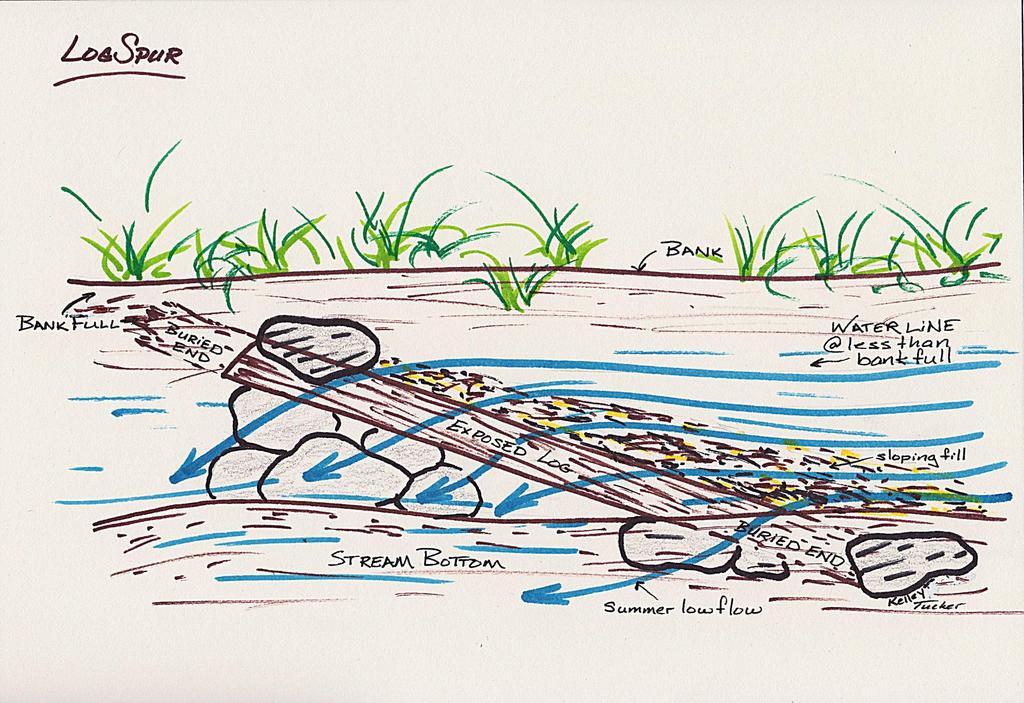
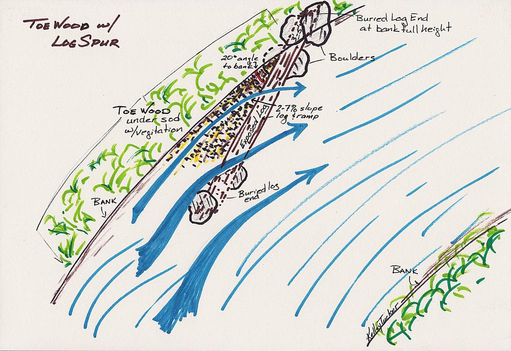
19 Use of wood in restoration/habitat Roughening banks & riparian zone Sediment deposition & Scour Flow deflection (Log Vanes) Disrupt helical flows (Log Jams, Toe Wood) Habitat fish & bugs Toe Wood, Log Jams Narrowing over- wide channels (Toe Wood, Root wads, Log vanes) 19
20 Log Vanes Designed to roll energy away from bank & so stop erosion (typical use on bends) degree angle to bank, extending 1/3 of channel width, pointing upstream & sloping 6-8 deg from bankfull to thalweg Cheap, local materials, simple to install, durable Construction sequence 20

21 1 st bend: lay out 3 log vanes to deflect energy from bank, deepen + habitat 21

22 Trench in 4-6% grade & 25 degr 22

23 Tack on filter fabric to anchored vane 23

24 Tips & butts anchored & braced 24

25 Add river cobble to fill in ramp face 25

26 3 completed vanes: check current shifts, where would trout lie? 26
27 27
28 28
29 Root Wads 15 log with 10 root fan & DBH set in deep trench on footer log, with root fan perpendicular to flow, anchored & buried so much of root fan is submerged all flows No longer recommended for bank stabilization Best current uses: To roughen margins (2007 USFS) To narrow channel (2008 USFWS) As part of Toe Wood Structure (2008 Rosgen) 29

30 Battenkill VT: dimension, pattern, profile, riparian zone all OK. Deficit: boundary roughness Solution: anchored LWD 5X Trout population 30

31 Anchored Rootwad Battenkill VT 31
32 Rootwads to narrow a low flow channel & improve sinuosity Use alternate sides at 45 deg angle pointing upstream Half entrench log & root fan into bed extending back to ~.5 bankfull at bank Brace & anchor with boulders Problems none to date Yield very good to excellent (Irene tested!) Cheap! 32

33 Adding root wads for habitat & improving w/d ratio in over wide habitat poor reach (rock anchors) 33
")
34 Just upstream 43 rootwads added to alternate sides (trout # 3X or more) 34
35 Toe Wood Structure Remarkably effective on eroding bends Great instant habitat trout, bugs, all fish Low cost ~ $40 - $50/ LF if free local materials Very durable (even to large flood events) Placed low, kept wet, good access to a bankfull bench to reduce local flood energy on bank Looks natural Caveats follow specs, lots of ballast, revegetate, consider log vanes at both ends 35

36 Bends 1 & 4: adding 1140 of Toe Wood Structure in front of bank 36

37 Logs laid 10 on center with footers, braces & rock ballast 37

38 Next: skidder hauls in tree tops 38

39 Then hay or coir mat laid on tree tops/brush _I_ to bank, then gravel or soil 39

40 Then live willow poles, coir mat, more soil 40

41 2nd TWS: Roughness, narrowing => bank resiliency, Habitat, sediment transport, reconnect to flood plain 41

42 2 nd & 3 rd Toe Wood Structures 42

43 2 weeks post 2 nd flood 1140 intact 43

44 2 nd TWS post 10 floods 44
Geomorphic Stream Classification A Classification of Natural Rivers, Rosgen, D.L.
 Geomorphic Stream Classification A Classification of Natural Rivers, Rosgen, D.L. Why is Stream Classification Physical stream channel evolution Essential? Similar stream types manifest similar patterns
Cross-Vane Plan View FIN-UP Habitat Consultants, Inc. 220 Illinois Avenue Manitou Springs, CO (719) P.
 P.") STREAM CHANNEL STRUCTURE DRAWINGS ISIONS W (Channel Width) (Varies) Thalweg & Flow Direction Individually Placed Footer Rocks 5' to 6' by 2' thick (Min. 2 rows of footer rocks placed tightly together with
STREAM CHANNEL STRUCTURE DRAWINGS ISIONS W (Channel Width) (Varies) Thalweg & Flow Direction Individually Placed Footer Rocks 5' to 6' by 2' thick (Min. 2 rows of footer rocks placed tightly together with
Habitat Conditions, Design Strategies,
 Habitat Conditions, Design Strategies, Coho on Cedar Ck. five years after analog-based stream restoration work. and Stream Classification In river work, computer modeling is an insidious procedure in which
Rehabilitation of Grimes Creek, a Stream Impacted in the Past by Bucket-lined Dredge Gold Mining, Boise River Drainage, July 2008 to August 2011.
 Rehabilitation of Grimes Creek, a Stream Impacted in the Past by Bucket-lined Dredge Gold Mining, Boise River Drainage, July 2008 to August 2011. Pam Harrington TU,1020 W. Main Street Suite 440, Boise,
Culvert Design for Low and High Gradient Streams in the Midwest. Dale Higgins, Hydrologist Chequamegon-Nicolet National Forest
 Culvert Design for Low and High Gradient Streams in the Midwest Dale Higgins, Hydrologist Chequamegon-Nicolet National Forest Overview Culvert Design Considerations Hydraulic Terms Culvert Impacts Low
Hydraulic Modeling of Stream Enhancement Methods
 Hydraulic Modeling of Stream Enhancement Methods Matthew J. Curry John J. Levitsky Abstract Development within watersheds increases the amounts of runoff causing stream erosion and degradation of stream
Mid-Columbia Fisheries Enhancement Group Annual Report Fiscal Year 06: July 1, 2005 June 30, 2006
 Mid-Columbia Fisheries Enhancement Group Annual Report Fiscal Year 06: July 1, 2005 June 30, 2006 Mission Statement The mission of the Mid-Columbia Fisheries Enhancement Group is to restore self-sustaining
Stream Assessment. Date. Data Collected by. Location. Name of Stream and River Basin. Stream Order. Streambank Materials. Streambank Vegetation
 Stream Assessment Date Data Collected by Location Name of Stream and River Basin Stream Order Streambank Materials Streambank Vegetation Floodplain Soils Floodplain Vegetation Valley Type Valley Constraints
HARRY AND LAURA NOHR CHAPTER OF TROUT UNLIMITED
 HARRY AND LAURA NOHR CHAPTER OF TROUT UNLIMITED BLUE RIVER HABITAT IMPROVEMENT PROJECT 2017 Report Prepared by the Project Committee Harry and Laura Nohr Chapter of Trout Unlimited 1 Sponsorship and Partners
MCCAW REACH RESTORATION
 Final Report MCCAW REACH FISH RESTORATION PHASE B Jack McCaw Inland Empire Action Coalition http://www.wwccd.net/ Phone: 509-956-3777 Hours: 8:00-4:30 Walla Walla County Conservation District Snake River
Climate Change Adaptation and Stream Restoration. Jack Williams;
 Climate Change Adaptation and Stream Restoration Jack Williams; jwilliams@tu.org 1 Goals for this presentation Develop strategies for adapting streams to climate impacts by Thinking like a watershed Understanding
Fish Habitat Restoration and Monitoring in Southeast Washington. Andy Hill Eco Logical Research, Inc.
 Fish Habitat Restoration and Monitoring in Southeast Washington Andy Hill Eco Logical Research, Inc. Fish Habitat Restoration and Monitoring in Southeast Washington Talk overview: Restoration projects
Minnesota Department of Natural Resources Division of Fish and Wildlife Section of Fisheries. Stream Survey Report. Luxemburg Creek.
 Minnesota F-29-R(P)-24 Area 315 Study 3 March 2016 Minnesota Department of Natural Resources Division of Fish and Wildlife Section of Fisheries Stream Survey Report Luxemburg Creek 2015 Mark Pelham Sauk
Aquatic Organism Passage at Road-Stream Crossings CHUCK KEEPORTS FOREST HYDROLOGIST ALLEGHENY NATIONAL FOREST WARREN, PENNSYLVANIA
 Aquatic Organism Passage at Road-Stream Crossings CHUCK KEEPORTS FOREST HYDROLOGIST ALLEGHENY NATIONAL FOREST WARREN, PENNSYLVANIA TOPICS COVERED Aquatic Organism Passage (AOP) Benefits of AOP Crossings
Steelhead Society of BC. Thompson River Watershed Restoration and Enhancement Project #4 Nicola River Bank Stabilization and Enhancement Project
 Steelhead Society of BC Presents: Thompson River Watershed Restoration and Enhancement Project #4 Nicola River Bank Stabilization and Enhancement Project Application for Funding December 2013 1.0 BACKGROUND
PROJECT TO INSTALL LARGE WOOD HABITAT STRUCTURES IN THE CARMEL RIVER USING CALIFORNIA DEPARTMENT OF FISH AND GAME GRANT FUNDS
 PROJECT TO INSTALL LARGE WOOD HABITAT STRUCTURES IN THE CARMEL RIVER USING CALIFORNIA DEPARTMENT OF FISH AND GAME GRANT FUNDS The Monterey Peninsula Water Management District (MPWMD), in cooperation with
Big Spring Creek Habitat Enhancement and Fishery Management Plans
 Big Spring Creek Habitat Enhancement and Fishery Management Plans November 5, 2012 Big Spring Events and Activities Center Newville, PA Charlie McGarrell Regional Habitat Biologist Pennsylvania Fish and
Stevens Creek Corridor
 O F F I C E O F T H E D I R E C T O R O F P U B L I C W O R K S Stevens Creek Corridor Creek Restoration Project Volume Three Project Update: Creek Photos, Before & After BY GAIL SEEDS - PROJECT MANAGER,
Illinois Lake Management Association Conference March 23, 2018 By Trent Thomas Illinois Department of Natural Resources Division of Fisheries
 Illinois Lake Management Association Conference March 23, 2018 By Trent Thomas Illinois Department of Natural Resources Division of Fisheries Sources of Habitat Impairment Sedimentation Channelization
Management of headwater streams in the White Mountain National Forest
 Management of headwater streams in the White Mountain National Forest White Mountain National Forest Weeks Act of 1911 authorized the federal government to purchase lands east of the Mississippi River
Kootenai River Habitat Restoration Program. Kootenai Tribe of Idaho - January 27, 2014 Presentation for Kootenai Valley Resource Initiative
 Kootenai River Habitat Restoration Program Kootenai Tribe of Idaho - January 27, 2014 Presentation for Kootenai Valley Resource Initiative Decline of native species Kootenai River White Sturgeon ENDANGERED
Minnesota Department of Natural Resources Division of Fish and Wildlife Section of Fisheries. Stream Survey Report. Three Mile Creek 2011
 Minnesota Department of Natural Resources Division of Fish and Wildlife Section of Fisheries Stream Survey Report Three Mile Creek 2011 By Joseph D. Stewig Montrose Area Fisheries Office TABLE OF CONTENTS
(Revised February,2005) CULVERTS, BRIDGES, AND FORDS
 CULVERTS, BRIDGES, AND FORDS") GUIDE TO STREAM CROSSINGS (Revised February,2005) CULVERTS, BRIDGES, AND FORDS Culverts, bridges, and fords are all methods used to cross-streams. Culverts are the most common stream crossing structure.
GUIDE TO STREAM CROSSINGS (Revised February,2005) CULVERTS, BRIDGES, AND FORDS Culverts, bridges, and fords are all methods used to cross-streams. Culverts are the most common stream crossing structure.
Report prepared for: Prepared by: January 2002 BEAK Ref
 AQUATIC ENVIRONMENTAL STUDY KANATA WEST CONCEPT PLAN Report prepared for: ROBINSON CONSULTANTS Prepared by: BEAK INTERNATIONAL INCORPORATED 14 Abacus Road Brampton, Ontario L6T 5B7 January 2002 BEAK Ref.
Ecology of Place: What salmon need Eric Beamer Skagit River System Cooperative. November 2010
 Ecology of Place: What salmon need Eric Beamer Skagit River System Cooperative November 2010 Acknowledgements NOAA Fisheries NW Fisheries Science Center Tim Beechie George Pess Correigh Greene Talk overview
Quantifying Performance of Stream Simulation Culverts in the Chehalis Basin, WA
 Quantifying Performance of Stream Simulation Culverts in the Chehalis Basin, WA AUTHORS: Joe Richards, Environmental Science Associates Jane Atha, Washington Department of Fish & Wildlife Colin Thorne,
Understanding the Impacts of Culvert Performance on Stream Health
 Understanding the Impacts of Culvert Performance on Stream Health Kristin Thomas Aquatic Ecologist Michigan Trout Unlimited Transportation and the Environment Conference 12/5/2018 Importance of adequately
Restoring the Kootenai: A Tribal Approach to Restoration of a Large River in Idaho
 Restoring the Kootenai: A Tribal Approach to Restoration of a Large River in Idaho Susan Ireland, Kootenai Tribe of Idaho Future of our Salmon Conference Technical Session August 2016 Healthy Floodplains,
Presented by Fred Halterman, URS Jennie Agerton, URS
 Presented by Fred Halterman, URS Jennie Agerton, URS What is Eco Friendly Culvert Design? Culvert design that: Maintains connectivity for aquatic organism migration Maintains connectivity for gene flow
Trout Unlimited Comments on the Scope of Environmental Impact Statement for the Constitution Pipeline Project, Docket No. PF12-9
 October 9, 2012 Kimberly D. Bose, Secretary Federal Energy Regulatory Commission 888 First Street, NE, Room 1A Washington, DC 20426 RE: Trout Unlimited Comments on the Scope of Environmental Impact Statement
Simulating Streams Through Culverts in Mat-Su, Alaska
 Simulating Streams Through Culverts in Mat-Su, Alaska Project Managers Bill Rice, P.E., USFWS Hydrologist Mary Price, USFWS Fishery Biologist The Team Approach US Fish and Wildlife Service Bill Rice, P.E.,
Biological Survey of Allagash Stream
 F i"shery Interim Summary Report Series No. 07-04 Biological Survey of Allagash Stream By Forrest R. Bonney Caring for Maine's Outdoor Future September, 2007 Maine Department of Inland Fisheries and Wildlife
Nechako white sturgeon are an Endangered Species
 Nechako white sturgeon are an Endangered Species There are likely less than 350 Nechako white sturgeon, and historically there were over 5000 in the Nechako Watershed. Endangered as per the Species at
Study No. 18. Mystic Lake, Montana. PPL Montana 45 Basin Creek Road Butte, Montana 59701
 Study No. 18 Evaluation of the Current Fish Population and Habitat in West Rosebud Creek Downstream from Emerald Lake Mystic Lake Hydroelectric Project FERC No. 2301 Mystic Lake, Montana PPL Montana 45
River Medway Upper Medway Fly Fishers
 River Medway Upper Medway Fly Fishers An Advisory Visit by the Wild Trout Trust April 2015 1 1. Introduction This report is the output of a site meeting and walk-over survey of a 2-km stretch of the River
Low Gradient Velocity Control Short Term Steep Gradient Channel Lining Medium-Long Term Outlet Control Soil Treatment Permanent [1]
![Low Gradient Velocity Control Short Term Steep Gradient Channel Lining Medium-Long Term Outlet Control Soil Treatment Permanent [1]](/thumbs/80/80811988.jpg "Low Gradient Velocity Control Short Term Steep Gradient Channel Lining Medium-Long Term Outlet Control Soil Treatment Permanent [1]") Check Dams DRAINAGE CONTROL TECHNIQUE Low Gradient Velocity Control Short Term Steep Gradient Channel Lining Medium-Long Term Outlet Control Soil Treatment Permanent [1] [1] Though not generally considered
Check Dams DRAINAGE CONTROL TECHNIQUE Low Gradient Velocity Control Short Term Steep Gradient Channel Lining Medium-Long Term Outlet Control Soil Treatment Permanent [1] [1] Though not generally considered
STUDY PERFORMANCE REPORT
 STUDY PERFORMANCE REPORT State: Michigan Project No.: F-80-R-4 Study No.: 702 Title: Effects of sediment traps on Michigan river channels Period Covered: October 1, 2002 to September 30, 2003 Study Objectives:
HEC 26 Aquatic Organism Passage Design Manual Evolution & Application
 HEC 26 Aquatic Organism Passage Design Manual Evolution & Application Sven Leon, P.E., Hydraulics Engineer Federal Highway Administration 2015 Alaska Fish Passage Meeting October 13 14, 2015 VTRC, Juneau,
3. The qualification raised by the ISRP is addressed in #2 above and in the work area submittal and review by the ISRP as addressed in #1.
 Please find attached a response from The Confederated Tribes of the Warm Springs Reservation of Oregon (CTWSRO) for Project # 2008-301-00, Habitat Restoration Planning, Design and Implementation within
Don Pedro Project Relicensing
 Don Pedro Project Relicensing M ODESTO I RRIGATION D ISTRICT TURLOCK I RRIGATION D ISTRICT FERC PROJECT N O. 2299 Resident Fish in Don Pedro Reservoir Don Pedro Reservoir Fish Stocking (1971-Present) CDFG
Joe Rathbun Michigan DEQ Water Resources Division Nonpoint Source Unit * Thanks to The Nature Conservancy
 Joe Rathbun Michigan DEQ Water Resources Division Nonpoint Source Unit rathbunj@mi.gov * Thanks to The Nature Conservancy Road-stream intersections = 67,511 Culverts = 60,700 Bridges = 6,811 Perched Piping
Added Introduction: Comparing highway design and stream design
 Added Introduction: Comparing highway design and stream design Highway width is sized for the traffic, the width expanding as volume and speed increase. The ROW width is also designed to handle the speed
LONGITUDINAL FIELD METHODOLOGY FOR THE ASSESSMENT OF TMDL SEDIMENT AND HABITAT IMPAIRMENTS
 LONGITUDINAL FIELD METHODOLOGY FOR THE ASSESSMENT OF TMDL SEDIMENT AND HABITAT IMPAIRMENTS Montana Department of Environmental Quality 1520 East Sixth Avenue Helena, Montana 59620 June 2007 TABLE OF CONTENTS
Chutes Part 2: Synthetic linings
 s Part 2: Synthetic linings DRAINAGE CONTROL TECHNIQUE Low Gradient Velocity Control Short Term Steep Gradient Channel Lining Medium-Long Term Outlet Control [1] Soil Treatment Permanent [2] [1] s can
Cornwell brook Cornwell Manor
 Cornwell brook Cornwell Manor An Advisory Visit by the Wild Trout Trust February 2014 1 1. Introduction This report is the output of a Wild Trout Trust visit to a tributary of the Cornwell Brook at Cornwell
2012 SOUTH RIVER FISH COMMUNITIES AND PHYSICAL HABITAT ASSESSMENT, FRANKLIN COUNTY, MASSACHUSETTS
 2012 SOUTH RIVER FISH COMMUNITIES AND PHYSICAL HABITAT ASSESSMENT, FRANKLIN COUNTY, MASSACHUSETTS Prepared by Michael B. Cole, Ph.D. ABR, Inc. Environmental Research & Services Greenfield, MA For Deerfield
Fish Habitat Design, Operation and Reclamation Worksheets for
 Fish Habitat Design, Operation and Reclaation Worksheets for Appendix A Project Location Worksheet Applicant Nae: Strea Nae: Watershed Nae: Fish Habitat Suitability Classification Water Quality Zone Operation
Understanding Types and Benefits of Fish Habitat
 Understanding Types and Benefits of Fish Habitat Leonard Dane Fisheries Biologist Deuchler Environmental, Inc. ILMA POD April 14, 2015 Wauconda, IL Importance of Fish Habitat What is fish habitat? those
Five Counties Salmonid Conservation Program - Fish Passage Design Workshop. February 2013
 Program - Aquatic Organisms and Stream Crossings Ecological Connectivity A watershed is a network of channels that drain a common boundary. Channel characteristics formed by interaction of precipitation,
USDI Bureau of Land Management Roseburg, Oregon District. Larry Standley Hydrologist Cory Sipher Fisheries Biologist Rick Shockey District Engineer
 USDI Bureau of Land Management Roseburg, Oregon District Larry Standley Hydrologist Cory Sipher Fisheries Biologist Rick Shockey District Engineer 1 Introduction Background why model buoyancy? The buoyant
Habitat Development: Habitat Boulders Lawson Pier Foreshore Enhancement
 Habitat Development: Habitat Boulders Improve the existing habitat by stabilising beach sediments. Increase biodiversity by creating new habitats and colonisation opportunities. Loose cobble is unstable;
Delaware Basin Stream Management Program
 Delaware Basin Stream Management Program A partnership between NYCDEP and Delaware County Soil & Water Conservation District 2015 Update Delaware Basin - Topics 2015 Project Updates Restoration Projects
JAP Additional Information Sheet
 JAP Additional Information Sheet Block 15: Purpose and Need The USACE purpose of the project is to provide a safe and reliable whitewater park for the recreational public in a city park, which will provide
Brook Trout Life Cycle and Habitat
 Brook Trout Life Cycle and Habitat Directions: 1. As you watch this slide show, watch for vocabulary terms we learned today. The first time they appear, you will see them in RED! (not redd!) 2. At the
South Platte River Happy Meadows Reach 22 River Restoration Plan March 2010
 South Platte River Happy Meadows Reach 22 River Restoration Plan March 200 The following document describes the treatments to be implemented on the South Platte River in the area known as Happy Meadows.
Sub-watershed Summaries
 Project Description The Salmon Drift Creek Watershed Council (SDCWC) has focused their efforts in the Salmon River estuary for the past few years. The multifaceted partnership effort is nearing completion
Preakness Brook - FIBI098
 Preakness Brook - FIBI098 Preakn ess B rook Preakness " ( FIBI098 Naachtpunkt Brook 202 80 IBI Ratings FIBI Sampling Location Excellent Small Streams (1st and 2nd Order) Good Fair Large Streams (3rd Order
Assessment of Baseline Geomorphic Features at. Proposed Stream Crossings On The Proposed County Road 595. Marquette County, Michigan
 Assessment of Baseline Geomorphic Features at Proposed Stream Crossings On The Proposed County Road 595 Marquette County, Michigan Prepared for: Kennecott Eagle Minerals Company Marquette, Michigan Prepared
FINAL REPORT. Yonkers Creek Migration Barrier Removal Project Wonderstump Road Del Norte County. Submitted By:
 FINAL REPORT Yonkers Creek Migration Barrier Removal Project Wonderstump Road Del Norte County Submitted By: Del Norte County Community Development Department Yonkers Creek Migration Barrier Removal Project
FACT SHEET MCGREGOR LAKE RESTORATION HABITAT PROJECT POOL 10, UPPER MISSISSIPPI RIVER, WISCONSIN ENVIRONMENTAL MANAGEMENT PROGRAM
 FACT SHEET MCGREGOR LAKE RESTORATION HABITAT PROJECT POOL 10, UPPER MISSISSIPPI RIVER, WISCONSIN ENVIRONMENTAL MANAGEMENT PROGRAM LOCATION McGregor Lake is located within a mid-river island in Pool 10
PRE- PROPOSAL FORM - 1. Applicant organization. USDA Forest Service Gifford Pinchot National Forest & WDFW Region 5
 PRE- PROPOSAL FORM - 1. Applicant organization. USDA Forest Service Gifford Pinchot National Forest & WDFW Region 5 2. Organization purpose USFS-Resource management agency WDFW-Fish and Wildlife management
Identifying Areas with Potential to Contain High Value Fish Habitat (HVFH) June 2007
 June 2007") Identifying Areas with Potential to Contain High Value Fish Habitat (HVFH) June 2007 1 High Value Fish Habitat INTENT: To apply added precautionary protection to those special areas deemed of high value
Identifying Areas with Potential to Contain High Value Fish Habitat (HVFH) June 2007 1 High Value Fish Habitat INTENT: To apply added precautionary protection to those special areas deemed of high value
Massachusetts Stream Crossing Case Studies
 Massachusetts Stream Crossing Case Studies Amy Singler Associate Director, River Restoration Program Carrie Banks River Continuity Coordinator Case Studies: Public Benefits: Movement of goods and people
Draft report on one day visit to Brampton Bryan, R. Teme
 Dr Nick Giles & Associates, 50 Lake Road, Verwood, Dorset, BH31 6BX. Telephone 01202 824245 Fax 01202 828056 email nickgiles@cix.co.uk Consultants : Freshwater Fisheries, Conservation & Wetland Ecology
At Home on the Elbow River. -Ours to share-
 At Home on the Elbow River -Ours to share- Living in the shed You are part of the Elbow River Watershed. The Elbow River and its tributaries drain over 1,200 km² of land. The source of the Elbow River
Estuarine Shoreline Stabilization
 Estuarine Shoreline Stabilization Property Owner s Guide to Determining the Most Appropriate Stabilization Method Estuarine shorelines are dynamic features that experience continued erosion. Land is lost
FISH PASSAGE IMPROVEMENT in California s Watersheds. Assessments & Recommendations by the Fish Passage Forum
 FISH PASSAGE IMPROVEMENT in California s Watersheds Assessments & Recommendations by the Fish Passage Forum FISH PASSAGE IMPROVEMENT in California s Watersheds The mission of the Fish Passage Forum is
Packwood Hydroelectric Project Barrier Analysis December 12, 2006
 Packwood Hydroelectric Project Barrier Analysis December 12, 2006 Study Area Natural barriers to upstream fish passage on Lake Creek at RM 1.03 and RM 1.95 Snyder Creek culvert under the Project tailrace
DRAFT. Stonybrook Creek Watershed
 DRAFT Stonybrook Creek Watershed A Strategic Plan for Eliminating Barriers to Steelhead Migration June 4, 2010 Prepared by: PO Box 4477, Arcata, CA 95518 mlove@h2odesigns.com / (707) 476 8938 Prepared
OKANAGAN RIVER RESTORATION INITIATIVE - FAQ
 OKANAGAN RIVER RESTORATION INITIATIVE - FAQ Initiative background: The health of the q awsitk w (Okanagan River) has been severely impacted by the channelization works that occurred in the mid-1950 s.
Incorporating Geomorphic Processes and Sediment Dynamics into Salmonid Habitat Restoration Design
 Salmonid Restoration Federation 35 th Annual Salmonid Restoration Conference Davis, CA Incorporating Geomorphic Processes and Sediment Dynamics into Salmonid Habitat Restoration Design Concurrent Session:
Overview of the Trinity River
 Overview of the Trinity River The Trinity River The Trinity River begins in the rugged Trinity Alps in northwestern California. On its journey, it tumbles through steep canyons and meanders through broad
Juvenile Steelhead and Stream Habitat Conditions Steelhead and Coho Salmon Life History Prepared by: DW ALLEY & Associates, Fishery Consultant
 Juvenile Steelhead and Stream Habitat Conditions Steelhead and Coho Salmon Life History Prepared by: DW ALLEY & Associates, Fishery Consultant I-1. Steelhead and Coho Salmon Ecology Migration. Adult steelhead
Mountain Columbia Province
 Rolling Provincial Review: Implementation 2001-2003 Province 229 Columbia Basin Fish & Wildlife Authority Province FY 2001-2003 Spending Summaries NPCC Recommendations and BPA Spending by Project Category,
APPENDIX B HYDRAULIC DESIGN DATA FOR CULVERTS
 TM 5-820-4/AFM 88-5, Chap 4 APPENDIX B HYDRAULIC DESIGN DATA FOR CULVERTS B-1. General. a. This appendix presents diagrams, charts, coefficients and related information useful in design of culverts. The
HURON RIVER WATERSHED
 Brown bullhead (Ameiurus nebulosus) feeding - larger streams and rivers, lakes and impoundments - clear cool water with little clayey silt - moderate amounts of aquatic vegetation - sand, gravel, or muck
Minnesota Department of Natural Resources Division of Fish and Wildlife Section of Fisheries. Fairhaven Creek 2000
 Minnesota F-29-R(P)-17 Area 340 Study 3 April 2001 Minnesota Department of Natural Resources Division of Fish and Wildlife Section of Fisheries Stream Survey Report Fairhaven Creek 2000 By Eric R. Altena
FISHERIES BLUE MOUNTAINS ADAPTATION PARTNERSHIP
 FISHERIES A warming climate, by itself, substantially affects the hydrology of watersheds in the Blue Mountains. Among the key hydrologic changes projected under all scenarios for the 2040s and beyond
Rock Ramp Design Guidelines. David Mooney MS Chris Holmquist-Johnson MS Drew Baird Ph.D. P.E. Kent Collins P.E.
 Rock Ramp Design Guidelines David Mooney MS Chris Holmquist-Johnson MS Drew Baird Ph.D. P.E. Kent Collins P.E. Rock Ramp Design Guidelines OUTLINE Local and System Interactions with Rock Ramps Ramp Geometry
Native Suckers of the Chuska Mountains and Defiance Plateau GLENN SELBY-FISH BIOLOGIST
 Native Suckers of the Chuska Mountains and Defiance Plateau GLENN SELBY-FISH BIOLOGIST Native Species on the Chuska Mts and Defiance Plateau Speckled Dace Bluehead sucker Zuni bluehead sucker Native Suckers
Suitable Applications Check dams may be appropriate in the following situations: To promote sedimentation behind the dam.
 Categories EC Erosion Control SE Sediment Control TC Tracking Control WE Wind Erosion Control Non-Stormwater NS Management Control Waste Management and WM Materials Pollution Control Legend: Primary Category
STEELHEAD SURVEYS IN OMAK CREEK
 STEELHEAD SURVEYS IN OMAK CREEK 2002 Annual Report Prepared by Chris Fisher John Arterburn Colville Confederated Tribes Fish and Wildlife Department P.O. Box 150 Nespelem, WA 99155 Prepared for Project
Ecology of stream-rearing salmon and trout Part II
 Ecology of stream-rearing salmon and trout Part II Individual Feeding territory Habitat use Growth Movement Survival Population Population Abundance Density Variation Movement Individual Relationship between
Overview of typical compensation measures and results of the monitoring campaign on the Upper Rhine at two HPPs
 Overview of typical compensation measures and results of the monitoring campaign on the Upper Rhine at two HPPs / FIThydro, Augsburg / Jochen Ulrich Overview Upper Rhine HPP Rheinfelden and Ryburg-Schwörstadt
River Restoration: Culvers Island weir removals and river naturalisation project.
 River Restoration: Culvers Island weir removals and river naturalisation project. Background Chalk streams are an incredibly rare habitat on a global scale, and owing to their international importance,
Blakely Island, N Thatcher Bay. Restoration Recommendation: Rank Score (total score)
") Soft Shore Protection/Structure Removal Blueprint for San Juan County Forage Fish Beaches Appendix 2: Recommendations for sites scoring below the top ten, sorted by island (east to west) Blakely Island,
Soft Shore Protection/Structure Removal Blueprint for San Juan County Forage Fish Beaches Appendix 2: Recommendations for sites scoring below the top ten, sorted by island (east to west) Blakely Island,
Study Update Tailrace Slough Use by Anadromous Salmonids
 Study Update Tailrace Slough Use by Anadromous Salmonids Goals and Objectives Identify what anadromous salmonids use the tailrace slough by: Life Stage (Juvenile, migrating and spawning adults) Timing
Lewis River Bull Trout Habitat Restoration Project Identification Assessment
 Lewis River Bull Trout Habitat Restoration Project Identification Assessment Jamie Lamperth 1, Bryce Michaelis 2, and Abi Groskopf 3 1 Washington Department of Fish and Wildlife, Fish Ecology and Life
Reconnecting Waters; Reconnecting Roads
 Reconnecting Waters; Reconnecting Roads Laura MacFarland, Great Lakes Stream Restoration Manager Wisconsin Lakes Convention Stevens Point, WI April 19, 2018 www.tu.org Overview Reconnecting Waters; Reconnecting
Historical Disturbances
 MINNESOTA DEPARTMENT OF NATURAL RESOURCES The Science(s) behind Managing Stream Fishery Resources Lake Superior Area Office, Section of Fisheries Historical Disturbances Thaddeus Surber, 1923: Because
Water surface slope extending up to 20 channel widths up and downstream of crossing.
 Site Evaluations Site Information Site Location: Mt ood NF, Forest Road 7 Year Installed: Pre-987 Lat/Long: 8 W Watershed rea (mi ): N Stream Slope (ft/ft) : Channel Type: Step-pool ankfull Width (ft):
Data Report : Russian River Basin Steelhead and Coho Salmon Monitoring Program Pilot Study
 Data Report 1999-1: Russian River Basin Steelhead and Coho Salmon Monitoring Program Pilot Study Sonoma County Water Agency 215 West College Avenue Santa Rosa, California 951 Prepared by David Cook Senior
Fraser River. FISH SURVEY AND MANAGEMENT INFORMATION Jon Ewert - Aquatic Biologist (Hot Sulphur Springs)
") Fraser River FISH SURVEY AND MANAGEMENT INFORMATION Jon Ewert - Aquatic Biologist (Hot Sulphur Springs) General Information: The Fraser River is a highly diverse river offering many transitions in habitat
Fraser River FISH SURVEY AND MANAGEMENT INFORMATION Jon Ewert - Aquatic Biologist (Hot Sulphur Springs) General Information: The Fraser River is a highly diverse river offering many transitions in habitat
APPENDIX C VEGETATED EMERGENCY SPILLWAY. VERSION 1.0 March 1, 2011
 APPENDIX C VEGETATED EMERGENCY SPILLWAY VERSION 1.0 March 1, 2011 [NOTE: Could use a better photo more clearly showing the emergency spillway in the context of the dam.] SECTION C-1: DESCRIPTION OF PRACTICE
CALIFORNIA SALMONID STREAM HABITAT RESTORATION MANUAL APPENDIX IX-A CULVERT CRITERIA FOR FISH PASSAGE INTRODUCTION
 APPENDIX IX-A STATE OF CALIFORNIA RESOURCES AGENCY DEPARTMENT OF FISH AND GAME CULVERT CRITERIA FOR FISH PASSAGE For habitat protection, ecological connectivity should be a goal of stream-road crossing
Minnesota Department of Natural Resources Division of Fish and Wildlife Section of Fisheries. Stream Survey Report. Cold Spring Creek.
 Minnesota F-29-R(P)-24 Area 315 Study 3 March 2013 Minnesota Department of Natural Resources Division of Fish and Wildlife Section of Fisheries Stream Survey Report Cold Spring Creek 2012 Mark Pelham Montrose
Beaver Brook - FIBI047 Hope
 Beaver Brook - FIBI047.-,80 Silve r Lake Mud dy Br ook % Hope Honey Run Beaver Brook FIBI047 #S #S FIBI Sampling Location Small Streams (1st and 2nd Order) Large Streams (3rd Order and Above) N 0 1 2 3
Fish Friendly Crossings- Examples from Nash Stream
 Fish Friendly Crossings- Examples from Nash Stream Maggie Machinist- North Regional Forester, Division of Forests and Lands. Nash Stream Nash Stream Forest is 40,000 acres, owned and managed by NH Division
Identifying and Executing Stream Projects Kristin Thomas, Aquatic Ecologist MITU
 Identifying and Executing Stream Projects Kristin Thomas, Aquatic Ecologist MITU Introduction 1. Methods for Identifying Projects 2. Methods in Action 3. The Partnership Paradigm 2 River Stewards Program
Great Lakes Stream Crossing Inventory Instructions
 Great Lakes Stream Crossing Inventory Instructions This document is a guide to completing the Stream Crossing Data Sheet (2/28/11 version). Careful attention to this guidance will ensure consistent crossing