Delaware Basin Stream Management Program
|
|
|
- Theresa Alexander
- 5 years ago
- Views:
Transcription


1 Delaware Basin Stream Management Program A partnership between NYCDEP and Delaware County Soil & Water Conservation District 2015 Update
2 Delaware Basin - Topics 2015 Project Updates Restoration Projects SMIP Projects CSBI Projects 2016 Project Updates Restoration Projects CSBI Projects CREP Projects Local Flood Analysis (LFA) Updates 2
 through the Department of Watershed Affairs matched with DEP funds ($170 K) to stabilize slopes contributing")
 exceeded WRDA funding so")
3 Third Brook Third Brook stream bed instability and hill slope failures Third Brook hill slope failures were identified in the Third Brook Watershed Management Plan ACOE WRDA funded ($510 K) through the Department of Watershed Affairs matched with DEP funds ($170 K) to stabilize slopes contributing sediment and woody debris to Third Brook above the Village of Walton Goal was to reduce stress on slope toe, halt head cuts and bed degradation upstream, and reduce sediment deposition downstream in the village Originally projected costs to address all slopes (1-9) exceeded WRDA funding so project was segmented

4 Third Brook Sites 8 & 9 Original work took place in 2014 Spring 2015 rains resulted in flanking of EWP structure and stream bank failure Some ACOE funds remained from 2014 construction and were available for emergency repair work on these slopes DCSWCD also requested additional funds from DEP to facilitate the emergency work
 along the toe of slope Total length: 1,145.")
5 Third Brook - Sites 8 & 9 Design DCSWCD requested design assistance from Milone & MacBroom through DEP The project was in part an emergency repair with additional funds provided to install boulder riffle structures and revetment (rip-rap) along the toe of slope Total length: 1,145.5 ft Total Cost: $807,638 (2014 & 2015)

6 Third Brook Sites 8 & 9 Construction


7 Gulf Brook Streambank SMIP Located in the Town of Andes Bank erosion along a town road due to channel incision caused by the 2007 flood The project was awarded a SMIP grant in 2011, design postponed to 2014 due to Hurricane Irene in 2011 and EWP projects Project designed by DCSWCD 7

8 Gulf Brook Streambank SMIP Installation of pinned, stacked rock wall on right bank Installation of grade control structures downstream of wall Project completed in September 2015 at a cost of $71,102 8


9 Holiday Brook Restoration SMIP Located in the Town of Andes Stream bank instability exacerbated by unstable stream bed 9


10 Holiday Brook Restoration SMIP Installation of rip-rap to stabilize right Installation bank, of up grade stream control of culvert Installation structures (hardened of hardened riffles riffles) upstream and for grade control upstream and downstream of culvert downstream of culvert Project completed in September 2015 at a cost of $39,110


11 Delhi River Walk Hoyt Park SMIP grant for River Walk Design - $39,750 SMIP grant for completion of River Walk - $60,537 Improve stream riparian buffer Stabilize stream bank Remove invasive Japanese Knotweed 11


12 Delhi Boat Launch Hoyt Park SMIP grant for boat launch $61,200 Improve access for recreational activities: Boating Tubing Kayaking Fishing Village of Delhi was also awarded funding by: CWC Stormwater Retrofit Program $94,000 DOS Local Waterfront Revitalization Program $107,666 OPRHP Recreational Trails Grant Program $163,862 12
 and local contributions from the Town of Walton")

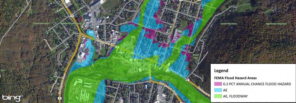
13 Walton Green Space Project Located f at the site of the former Walton Reporter building Goal is to allow conveyance of flood waters from Delaware Street back to West Branch Delaware River Walton Senator Bonacic grant ($100 K) and local contributions from the Town of Walton ($20,678), Village of Walton($33,295), and Delaware County ($17,685) for purchase and removal of Walton Reporter building Stream Management Program contributed $20,000 for floodplain grading and installation of stormwater infiltration trench Walton Greene Space $20,000 to complete final grading


14 Walton Gravel Study SMIP Walton High School Environmental Science students completed crosssectional surveys and pebble counts at eight stream sites in the Village of Walton from Determine if stream channel is aggrading, degrading, or in equilibrium Presented results to Walton Flood Commission on November 5, 2015 Elevation BRANDOW'S & BREAKEY'S 11/21/2013 5/21/2013 6/3/ /5/2015 Feet on the Cam Line
 2600 $2,414 Walton Greene Space $20,000 to complete final grading Walton Delhi:")


15 2015 CSBI Projects Project f Bank Length (feet) Amount Hamden: Terry Clove Native Planting 460 $5,690 Andes: Beech Hill Knotweed Control (year 3) 2600 $2,414 Walton Greene Space $20,000 to complete final grading Walton Delhi: Little Delaware Trib Post IS Control Native Planting 650 $4,762 New Kingston: Thomson Hollow IS Control 600 $730 New Kingston: Thomson Hollow Native Planting 680 $2,987 Walton: County Route 22 East Brook Native Planting 1420 $15,200 SUNY Delhi Outdoor Education Center Planting 375 $375 Roxbury Elementary School Planting 60 $43 Walton Third Brook Student Planting 720 $357 Walton Knotweed pull Delaware Avenue 4H 90 - Delhi Hoyt Park Knotweed pull and clean-up 325 -

")
16 2015 CSBI Projects Terry Clove Town of Hamden Total length: 460 feet Buffer width: 25 feet Acres: 0.32 Potted plants: 300 Herbaceous plugs: 428 Live stakes: 220 Little Delaware Tributary Town of Delhi Total length: 650 feet Buffer width: 15 feet (both sides) Acres: 0.21 Potted plants: 175 Herbaceous plugs: 448 Live stakes: 300
17 2015 SMIP Grants Awarded 2015 SMIP Grant Awards - approved by PAC on September 10, 2015 Recipient Type Project Stream Amount Village of Delhi River Walk West Branch $60,534 Delaware County DPW Streambank stabilization East Brook $285,522 Village of Walton Streambank stabilization West Branch $398,545 Town of Bovina Culvert replacement Little Delaware trib $268,188 Town of Tompkins Culvert design Carrol Hollow $30,000 Town of Hamden Streambank stabilization East Brook $66,366 Town of Walton Stream bed stabilization Beers Brook $31,645 Town of Middletown Culvert design Platte Kill trib $30,000 Town of Stamford Streambank stabilization Town Brook $31,527 Village of Hobart Streambank stabilization Grant Brook $22,910 Total $1,225,239 Delaware County SWCD also leveraged matching funds from the DEC WQIP for: Miller Avenue Culvert Replacement in Bovina $182,856 South Street Streambank Stabilization in Walton $763,732
18 Total SMIP Grants Awarded Project Type Number of Projects Streambank Restoration 10 Stormwater 3 Recreation 8 Education 1 Infrastructure 9 Flood Hazard Mitigation 4 Total Number of Projects 35 Total SMIP Funding Awarded $2,809,384.96

19 More Restoration Project Located in the Town of Hamden Site identified in WBDR Stream Management Plan as lacking adequate riparian buffer Gradual bar formation and down valley meander migration has resulted in over widened condition Project goals: Project site establish stable stream channel that maintains proper sediment transport establish riparian buffer for long term stability of reach 19


20 More Restoration Project - Tasks Determined hydrology and verified using multiple sources Identified bankfull indicators in April 2015 event and calibrated hydraulic model of bankfull to indicators Calculated cross-sectional area Calculated range for alignment geometry Determined potential alignments Obtained landowner agreements Working on cropland CREP facilitation Coordinating with the Farm Easement Program Planned to be constructed in
21 Other Projects 2016 SCMP Project # Projects Status 1 More Project in Hamden In Design 2 Little Delaware in Bovina 60% Design - SHPO archeology 3 Hamden Boat Launch Redesign for avoidance on archeology sensitive area 4 Walton Boat Launch Redesign for avoidance on archeology sensitive area 5 Walton Water St Floodplain Concept Design 6 Fleischmanns Site 4 Floodplain Designed (Buy-out on hold) 2016 CSBI Projects # Projects Status 1 Oliver Farm in Meredith Designed 2 Depot Street in Fleischmanns Designed 3 Willow Drive in Middletown In Design 2016 Ag Projects # Projects Status 1 Steve Boyd in Walton 60% Design 2 Laura Phoenix in Hamden 30% Design 3 Willard Frisbee in Delhi Concept Design
22 LFA Updates Delaware Basin Local Flood Analysis (LFA) Updates


23 Walton LFA Status of Implementation LFA completed for West Branch Delaware River in April 2015 Village of Walton has applied to CWC for funding to complete two feasibility studies that are associated with Water Street floodplain restoration: 1. CWC has approved funding for feasibility study for relocation of cell tower 2. CWC is reviewing funding application to complete feasibility study for relocation of underground infrastructure The Walton Flood Commission meets monthly to continue work on implementation of projects and review tributary analyses

24 Water Street Floodplain Restoration

25 Walton Tributary Analyses

26 East Brook Analysis

27 Status of Other LFAs Walton Flood Commission WBDR complete, tributaries underway (East Brook, West Brook, Third Brook) East Branch Flood Commission Fleischmanns & Clovesville nearing completion, awaiting draft report Arkville consultant evaluating alternatives Delhi Flood Commission Delhi & Fraser consultant completing hydraulic analysis Andes Flood Commission contract executed with consultant Hamden Flood Commission entering contract with consultant
 865-5223 www.catskillstreams.org/lfa")
28 Contact Information Nate Hendricks Project Manager NYCDEP Stream Management Program 71 Smith Avenue Kingston, NY (845) Graydon Dutcher Stream Program Coordinator DCSWCD 44 West Street, Suite 1 Walton, NY (607)
Culvert Design for Low and High Gradient Streams in the Midwest. Dale Higgins, Hydrologist Chequamegon-Nicolet National Forest
 Culvert Design for Low and High Gradient Streams in the Midwest Dale Higgins, Hydrologist Chequamegon-Nicolet National Forest Overview Culvert Design Considerations Hydraulic Terms Culvert Impacts Low
Aquatic Organism Passage at Road-Stream Crossings CHUCK KEEPORTS FOREST HYDROLOGIST ALLEGHENY NATIONAL FOREST WARREN, PENNSYLVANIA
 Aquatic Organism Passage at Road-Stream Crossings CHUCK KEEPORTS FOREST HYDROLOGIST ALLEGHENY NATIONAL FOREST WARREN, PENNSYLVANIA TOPICS COVERED Aquatic Organism Passage (AOP) Benefits of AOP Crossings
Geomorphic Stream Classification A Classification of Natural Rivers, Rosgen, D.L.
 Geomorphic Stream Classification A Classification of Natural Rivers, Rosgen, D.L. Why is Stream Classification Physical stream channel evolution Essential? Similar stream types manifest similar patterns
MCCAW REACH RESTORATION
 Final Report MCCAW REACH FISH RESTORATION PHASE B Jack McCaw Inland Empire Action Coalition http://www.wwccd.net/ Phone: 509-956-3777 Hours: 8:00-4:30 Walla Walla County Conservation District Snake River
PROJECT TO INSTALL LARGE WOOD HABITAT STRUCTURES IN THE CARMEL RIVER USING CALIFORNIA DEPARTMENT OF FISH AND GAME GRANT FUNDS
 PROJECT TO INSTALL LARGE WOOD HABITAT STRUCTURES IN THE CARMEL RIVER USING CALIFORNIA DEPARTMENT OF FISH AND GAME GRANT FUNDS The Monterey Peninsula Water Management District (MPWMD), in cooperation with
Conserving the Forests, Lakes and Streams of Northeast Michigan
 4241 Old US 27 South, Suite 2, Gaylord, Michigan 49735 (989) 448-2293 www.huronpines.org info@huronpines.org Prioritized Restoration Projects in the AuSable River Watershed Summer 2015 Update from Huron
Hydraulic Modeling of Stream Enhancement Methods
 Hydraulic Modeling of Stream Enhancement Methods Matthew J. Curry John J. Levitsky Abstract Development within watersheds increases the amounts of runoff causing stream erosion and degradation of stream
Mid-Columbia Fisheries Enhancement Group Annual Report Fiscal Year 06: July 1, 2005 June 30, 2006
 Mid-Columbia Fisheries Enhancement Group Annual Report Fiscal Year 06: July 1, 2005 June 30, 2006 Mission Statement The mission of the Mid-Columbia Fisheries Enhancement Group is to restore self-sustaining
Management of headwater streams in the White Mountain National Forest
 Management of headwater streams in the White Mountain National Forest White Mountain National Forest Weeks Act of 1911 authorized the federal government to purchase lands east of the Mississippi River
RESTORING THE CONNECTION BETWEEN CREEK AND LAKE: FRESH WATER ESTUARINE CREATION IN MISSISSAUGA
 RESTORING THE CONNECTION BETWEEN CREEK AND LAKE: FRESH WATER ESTUARINE CREATION IN MISSISSAUGA Jeff Doucette, Kenneth Dion and Sally-Beth Betts 6 th International Conference on Natural Channel Systems
APPENDIX J HYDROLOGY AND WATER QUALITY
 APPENDIX J HYDROLOGY AND WATER QUALITY J-1 Technical Report on Airport Drainage, Northern Sector Airport and Ordinance Creek Watershed / Preliminary Creek Constructed Natural Channel Culvert J-2 Preliminary
Kootenai River Habitat Restoration Program. Kootenai Tribe of Idaho - January 27, 2014 Presentation for Kootenai Valley Resource Initiative
 Kootenai River Habitat Restoration Program Kootenai Tribe of Idaho - January 27, 2014 Presentation for Kootenai Valley Resource Initiative Decline of native species Kootenai River White Sturgeon ENDANGERED
Trout Unlimited Comments on the Scope of Environmental Impact Statement for the Constitution Pipeline Project, Docket No. PF12-9
 October 9, 2012 Kimberly D. Bose, Secretary Federal Energy Regulatory Commission 888 First Street, NE, Room 1A Washington, DC 20426 RE: Trout Unlimited Comments on the Scope of Environmental Impact Statement
Suitable Applications Check dams may be appropriate in the following situations: To promote sedimentation behind the dam.
 Categories EC Erosion Control SE Sediment Control TC Tracking Control WE Wind Erosion Control Non-Stormwater NS Management Control Waste Management and WM Materials Pollution Control Legend: Primary Category
Hydrologic, Hydraulic and Geomorphic Technical Memorandum
 Appendix A Hydrologic, Hydraulic and Geomorphic Technical Memorandum 01054/8410233/14/Rohner_Alt_Analysis_Report Rohner Creek Flood Control, Habitat and Seismic Improvement Project Alternatives Analysis
Presented by Fred Halterman, URS Jennie Agerton, URS
 Presented by Fred Halterman, URS Jennie Agerton, URS What is Eco Friendly Culvert Design? Culvert design that: Maintains connectivity for aquatic organism migration Maintains connectivity for gene flow
The Spey Catchment Initiative
 The Spey Catchment Initiative Introducing the Spey Catchment Initiative The Spey Catchment Initiative is a new project which aims to help deliver the objectives of the River Spey Catchment Management Plan
Joe Rathbun Michigan DEQ Water Resources Division Nonpoint Source Unit * Thanks to The Nature Conservancy
 Joe Rathbun Michigan DEQ Water Resources Division Nonpoint Source Unit rathbunj@mi.gov * Thanks to The Nature Conservancy Road-stream intersections = 67,511 Culverts = 60,700 Bridges = 6,811 Perched Piping
Big Spring Creek Habitat Enhancement and Fishery Management Plans
 Big Spring Creek Habitat Enhancement and Fishery Management Plans November 5, 2012 Big Spring Events and Activities Center Newville, PA Charlie McGarrell Regional Habitat Biologist Pennsylvania Fish and
Report prepared for: Prepared by: January 2002 BEAK Ref
 AQUATIC ENVIRONMENTAL STUDY KANATA WEST CONCEPT PLAN Report prepared for: ROBINSON CONSULTANTS Prepared by: BEAK INTERNATIONAL INCORPORATED 14 Abacus Road Brampton, Ontario L6T 5B7 January 2002 BEAK Ref.
Steelhead Society of BC. Thompson River Watershed Restoration and Enhancement Project #4 Nicola River Bank Stabilization and Enhancement Project
 Steelhead Society of BC Presents: Thompson River Watershed Restoration and Enhancement Project #4 Nicola River Bank Stabilization and Enhancement Project Application for Funding December 2013 1.0 BACKGROUND
Stream Assessment. Date. Data Collected by. Location. Name of Stream and River Basin. Stream Order. Streambank Materials. Streambank Vegetation
 Stream Assessment Date Data Collected by Location Name of Stream and River Basin Stream Order Streambank Materials Streambank Vegetation Floodplain Soils Floodplain Vegetation Valley Type Valley Constraints
CATSKILL WATERSHED CORPORATION Board of Directors Meeting MINUTES May 1, 1 p.m.
 CATSKILL WATERSHED CORPORATION Board of Directors Meeting MINUTES @ 1 p.m. I. Call to Order II. III. Pledge of Allegiance: Led by Mark McCarthy. Roll Call of Directors Members Present: Arthur Merrill,
CALIFORNIA SALMONID STREAM HABITAT RESTORATION MANUAL APPENDIX IX-A CULVERT CRITERIA FOR FISH PASSAGE INTRODUCTION
 APPENDIX IX-A STATE OF CALIFORNIA RESOURCES AGENCY DEPARTMENT OF FISH AND GAME CULVERT CRITERIA FOR FISH PASSAGE For habitat protection, ecological connectivity should be a goal of stream-road crossing
Illinois Lake Management Association Conference March 23, 2018 By Trent Thomas Illinois Department of Natural Resources Division of Fisheries
 Illinois Lake Management Association Conference March 23, 2018 By Trent Thomas Illinois Department of Natural Resources Division of Fisheries Sources of Habitat Impairment Sedimentation Channelization
Building Coastal Resiliency at Plymouth Long Beach
 Building Coastal Resiliency at Plymouth Long Beach Department of Marine and Environmental Affairs March 30, 2017 Introducing Green Infrastructure for Coastal Resiliency Plymouth Long Beach & Warren s Cove
Fish Friendly Crossings- Examples from Nash Stream
 Fish Friendly Crossings- Examples from Nash Stream Maggie Machinist- North Regional Forester, Division of Forests and Lands. Nash Stream Nash Stream Forest is 40,000 acres, owned and managed by NH Division
(Revised February,2005) CULVERTS, BRIDGES, AND FORDS
 CULVERTS, BRIDGES, AND FORDS") GUIDE TO STREAM CROSSINGS (Revised February,2005) CULVERTS, BRIDGES, AND FORDS Culverts, bridges, and fords are all methods used to cross-streams. Culverts are the most common stream crossing structure.
GUIDE TO STREAM CROSSINGS (Revised February,2005) CULVERTS, BRIDGES, AND FORDS Culverts, bridges, and fords are all methods used to cross-streams. Culverts are the most common stream crossing structure.
Rehabilitation of Grimes Creek, a Stream Impacted in the Past by Bucket-lined Dredge Gold Mining, Boise River Drainage, July 2008 to August 2011.
 Rehabilitation of Grimes Creek, a Stream Impacted in the Past by Bucket-lined Dredge Gold Mining, Boise River Drainage, July 2008 to August 2011. Pam Harrington TU,1020 W. Main Street Suite 440, Boise,
Stevens Creek Corridor
 O F F I C E O F T H E D I R E C T O R O F P U B L I C W O R K S Stevens Creek Corridor Creek Restoration Project Volume Three Project Update: Creek Photos, Before & After BY GAIL SEEDS - PROJECT MANAGER,
Incorporating Geomorphic Processes and Sediment Dynamics into Salmonid Habitat Restoration Design
 Salmonid Restoration Federation 35 th Annual Salmonid Restoration Conference Davis, CA Incorporating Geomorphic Processes and Sediment Dynamics into Salmonid Habitat Restoration Design Concurrent Session:
FINAL REPORT. Yonkers Creek Migration Barrier Removal Project Wonderstump Road Del Norte County. Submitted By:
 FINAL REPORT Yonkers Creek Migration Barrier Removal Project Wonderstump Road Del Norte County Submitted By: Del Norte County Community Development Department Yonkers Creek Migration Barrier Removal Project
Blakely Island, N Thatcher Bay. Restoration Recommendation: Rank Score (total score)
") Soft Shore Protection/Structure Removal Blueprint for San Juan County Forage Fish Beaches Appendix 2: Recommendations for sites scoring below the top ten, sorted by island (east to west) Blakely Island,
Soft Shore Protection/Structure Removal Blueprint for San Juan County Forage Fish Beaches Appendix 2: Recommendations for sites scoring below the top ten, sorted by island (east to west) Blakely Island,
OVERVIEW OF MID-COLUMBIA FISHERIES ENHANCEMENT GROUP
 Mid-Columbia Fisheries Enhancement Group MISSION STATEMENT The Mid-Columbia Fisheries Enhancement Group is a non-profit organization dedicated to restoring selfsustaining salmon and steelhead populations
Simulating Streams Through Culverts in Mat-Su, Alaska
 Simulating Streams Through Culverts in Mat-Su, Alaska Project Managers Bill Rice, P.E., USFWS Hydrologist Mary Price, USFWS Fishery Biologist The Team Approach US Fish and Wildlife Service Bill Rice, P.E.,
Habitat Conditions, Design Strategies,
 Habitat Conditions, Design Strategies, Coho on Cedar Ck. five years after analog-based stream restoration work. and Stream Classification In river work, computer modeling is an insidious procedure in which
Total Suspended Solids, Stable Flow, and Wet Weather Event Monitoring in the Bass River Watershed. December The Cadmus Group, Inc.
 Total Suspended Solids, Stable Flow, and Wet Weather Event Monitoring in the Bass River Watershed December 2004 The Cadmus Group, Inc. Grand Valley State University Annis Water Resources Institute Submitted
HEC 26 Aquatic Organism Passage Design Manual Evolution & Application
 HEC 26 Aquatic Organism Passage Design Manual Evolution & Application Sven Leon, P.E., Hydraulics Engineer Federal Highway Administration 2015 Alaska Fish Passage Meeting October 13 14, 2015 VTRC, Juneau,
FISHERIES BLUE MOUNTAINS ADAPTATION PARTNERSHIP
 FISHERIES A warming climate, by itself, substantially affects the hydrology of watersheds in the Blue Mountains. Among the key hydrologic changes projected under all scenarios for the 2040s and beyond
Advancing Fish Passage in the Menomonee River Watershed
 University of Massachusetts - Amherst ScholarWorks@UMass Amherst International Conference on Engineering and Ecohydrology for Fish Passage International Conference on Engineering and Ecohydrology for Fish
Assessment of Baseline Geomorphic Features at. Proposed Stream Crossings On The Proposed County Road 595. Marquette County, Michigan
 Assessment of Baseline Geomorphic Features at Proposed Stream Crossings On The Proposed County Road 595 Marquette County, Michigan Prepared for: Kennecott Eagle Minerals Company Marquette, Michigan Prepared
What is a River Basin Restoration Priority? 1. Criteria for Selecting a Targeted Local Watershed (TLW) 2. Hiwassee River Basin Overview 3
 2. Hiwassee River Basin Overview 3") Hiwassee River Basin Restoration Priorities 2008 TABLE OF CONTENTS Introduction 1 What is a River Basin Restoration Priority? 1 Criteria for Selecting a Targeted Local Watershed (TLW) 2 Hiwassee River
Hiwassee River Basin Restoration Priorities 2008 TABLE OF CONTENTS Introduction 1 What is a River Basin Restoration Priority? 1 Criteria for Selecting a Targeted Local Watershed (TLW) 2 Hiwassee River
TREATING RIVERS RIGHT & EXAMPLES OF BEST USE OF WOOD IN RESTORATION
 TREATING RIVERS RIGHT & EXAMPLES OF BEST USE OF WOOD IN RESTORATION James Mac Cartney, TU River Restoration Specialist John Braico, MD, NY Council Resource Mgr Grassroots Trustee 1 Great Trout Streams
Table VI-Proj SITE-SPECIFIC MANAGEMENT MEASURES FOR THE ROOT RIVER WATERSHED
 00216268.DOC 300-1104 MGH/JEB/pk 01/31/14, 02/04/14 Table VI-Proj SITE-SPECIFIC MANAGEMENT MEASURES FOR THE ROOT RIVER WATERSHED LRC-01 Habitat Hoods Creek entire length Village of Mt. Various Reiterate
Added Introduction: Comparing highway design and stream design
 Added Introduction: Comparing highway design and stream design Highway width is sized for the traffic, the width expanding as volume and speed increase. The ROW width is also designed to handle the speed
Great Lakes Stream Crossing Inventory Instructions
 Great Lakes Stream Crossing Inventory Instructions This document is a guide to completing the Stream Crossing Data Sheet (2/28/11 version). Careful attention to this guidance will ensure consistent crossing
OPPORTUNITIES & CONSTRAINTS
 OPPORTUNITIES & CONSTRAINTS Grand Rapids Restoration August 2012 We have inherited the past; we can create the future Unknown TABLE OF CONTENTS ES-1 ES-1...... BACKGROUND CONCEPTUAL PLAN ES-2... OPPORTUNITIES
Restoring the Iconicc Lower Cache River
 Restoring the Iconicc Lower Cache River A new chapter holds promise of revitalizing cherished waters and woods The story of conservation in the lower Cache River and surrounding Big Woods of eastern Arkansas
COLUMBIA LAKE DAM REMOVAL PROJECT
 COLUMBIA LAKE DAM REMOVAL PROJECT Major Goals of the Columbia Lake Dam Removal: Reconnect 10 miles of the Paulins Kill River to the Delaware River, restoring natural flow regime and sediment transport.
Cornwell brook Cornwell Manor
 Cornwell brook Cornwell Manor An Advisory Visit by the Wild Trout Trust February 2014 1 1. Introduction This report is the output of a Wild Trout Trust visit to a tributary of the Cornwell Brook at Cornwell
USING A LABYRINTH WEIR TO INCREASE HYDRAULIC CAPACITY. Dustin Mortensen, P.E. 1 Jake Eckersley, P.E. 1
 USING A LABYRINTH WEIR TO INCREASE HYDRAULIC CAPACITY Dustin Mortensen, P.E. 1 Jake Eckersley, P.E. 1 Plum Creek Floodwater Retarding Structure No. 6 is located in an area of Kyle, Texas, that is currently
Introduction to Check Dams
 Introduction to Check Dams Kabul, Afghanistan February 2011 3 This watershed rehabilitation and restoration training was prepared by the U.S. Department of Agriculture (USDA) team of Jon Fripp (Civil Engineer
HARRY AND LAURA NOHR CHAPTER OF TROUT UNLIMITED
 HARRY AND LAURA NOHR CHAPTER OF TROUT UNLIMITED BLUE RIVER HABITAT IMPROVEMENT PROJECT 2017 Report Prepared by the Project Committee Harry and Laura Nohr Chapter of Trout Unlimited 1 Sponsorship and Partners
OFFICE OF STRUCTURES MANUAL FOR HYDROLOGIC AND HYDRAULIC DESIGN CHAPTER 13 CULVERTS APRIL 2011
 OFFICE OF STRUCTURES MANUAL FOR HYDROLOGIC AND HYDRAULIC DESIGN CHAPTER 13 CULVERTS APRIL 2011 APRIL 2011 Chapter 13 Culverts Table of Contents Foreword.3 13.1 Introduction.. 4 13.2 Policy 6 13.3 Passage
Little Traverse Bay Watershed Road/Stream Crossing Inventory
 Little Traverse Bay Watershed Road/Stream Crossing Inventory Completed by Tip of the Mitt Watershed Council with support from: Petoskey-Harbor Springs Area Community Foundation s Little Traverse Bay Protection
Kasaan to Goose Creek Road Project Project Description U.S. Army Corps of Engineers Permit The following table presents the mile point of the culverte
 Kasaan to Goose Creek Road Project Project Description U.S. Army Corps of Engineers Permit The following table presents the mile point of the culverted open water crossings, name of water crossing if known,
USDI Bureau of Land Management Roseburg, Oregon District. Larry Standley Hydrologist Cory Sipher Fisheries Biologist Rick Shockey District Engineer
 USDI Bureau of Land Management Roseburg, Oregon District Larry Standley Hydrologist Cory Sipher Fisheries Biologist Rick Shockey District Engineer 1 Introduction Background why model buoyancy? The buoyant
Salmon Run G.C. Hole 3: Tributary & Wetland Restoration
 Salmon Run G.C. Hole 3: Tributary & Wetland Restoration Preliminary Project Design December 23, 2014 Prepared By: Curry Soil and Water Conservation District & Swanson Ecological Services, LLC Project Location:
Saugus River Watershed Smelt Spawning Habitat Assessment
 Saugus River Watershed Smelt Spawning Habitat Assessment Final Report December 2012 Prepared by: Joan LeBlanc, Executive Director Saugus River Watershed Council In Partnership with: National Park Service
CATSKILL WATERSHED CORPORATION Board of Directors Meeting MINUTES February 6, 1:00 p.m.
 CATSKILL WATERSHED CORPORATION Board of Directors Meeting MINUTES @ 1:00 p.m. I. Call to Order II. III. Pledge of Allegiance: Led by David Warne Roll Call of Directors Michael Triolo requested -a moment
APPENDIX C VEGETATED EMERGENCY SPILLWAY. VERSION 1.0 March 1, 2011
 APPENDIX C VEGETATED EMERGENCY SPILLWAY VERSION 1.0 March 1, 2011 [NOTE: Could use a better photo more clearly showing the emergency spillway in the context of the dam.] SECTION C-1: DESCRIPTION OF PRACTICE
LONGITUDINAL FIELD METHODOLOGY FOR THE ASSESSMENT OF TMDL SEDIMENT AND HABITAT IMPAIRMENTS
 LONGITUDINAL FIELD METHODOLOGY FOR THE ASSESSMENT OF TMDL SEDIMENT AND HABITAT IMPAIRMENTS Montana Department of Environmental Quality 1520 East Sixth Avenue Helena, Montana 59620 June 2007 TABLE OF CONTENTS
Minnesota Department of Natural Resources Division of Fish and Wildlife Section of Fisheries. Stream Survey Report. Three Mile Creek 2011
 Minnesota Department of Natural Resources Division of Fish and Wildlife Section of Fisheries Stream Survey Report Three Mile Creek 2011 By Joseph D. Stewig Montrose Area Fisheries Office TABLE OF CONTENTS
Follow this and additional works at:
 University of Massachusetts Amherst ScholarWorks@UMass Amherst International Conference on Engineering and Ecohydrology for Fish Passage International Conference on Engineering and Ecohydrology for Fish
Ecology - when it comes to river restoration design, so what? Field Trip Guide to Dunham Creek, Blackfoot River Watershed
 Center for Riverine Science and Stream Re-naturalization Fifth Annual Conference Ecology - when it comes to river restoration design, so what? Field Trip Guide to Dunham Creek, Blackfoot River Watershed
APPENDIX C ESTIMATING SCOUR IN BOTTOMLESS ARCH CULVERTS
 OFFICE OF STRUCTURES MANUAL FOR HYDROLOGIC AND HYDRAULIC DESIGN CHAPTER 11, EVALUATING SCOUR AT BRIDGES APPENDIX C ESTIMATING SCOUR IN BOTTOMLESS ARCH CULVERTS APRIL 2011 APPENDIX C ESTIMATING SCOUR IN
Chadbourne Dam Repair and Fish Barrier
 Chadbourne Dam Repair and Fish Barrier Final Report for the Western Native Trout Initiative Prepared by: Carol Endicott Yellowstone Cutthroat Trout Conservation Biologist Montana Fish, Wildlife & Parks
DRAFT. Stonybrook Creek Watershed
 DRAFT Stonybrook Creek Watershed A Strategic Plan for Eliminating Barriers to Steelhead Migration June 4, 2010 Prepared by: PO Box 4477, Arcata, CA 95518 mlove@h2odesigns.com / (707) 476 8938 Prepared
GRAND RAPIDS RESTORATION GRAND RAPIDS REVITALIZATION
 GRAND RAPIDS RESTORATION RETURNING THE RAPIDS TO THE GRAND WHY IS THIS PLACE CALLED GRAND RAPIDS? We have been asking for over 100- years, where are the rapids? WHY IS THIS PLACE CALLED GRAND RAPIDS? compare
Minnesota Department of Natural Resources Division of Fish and Wildlife Section of Fisheries. Stream Survey Report. Cold Spring Creek.
 Minnesota F-29-R(P)-24 Area 315 Study 3 March 2013 Minnesota Department of Natural Resources Division of Fish and Wildlife Section of Fisheries Stream Survey Report Cold Spring Creek 2012 Mark Pelham Montrose
Waikanae River Environmental Strategy. 12. Arapawaiti/Otaihanga Reach
 74 Waikanae River Environmental Strategy 12. Arapawaiti/Otaihanga Reach Figure 12: Arapawaiti/Otaihanga Reach 75 PART C: Protecting and Improving the River Corridor / Arapawaiti/Otaihanga Reach Waikanae
Fish Passage Assessment of Private Stream Crossings on Lower Stonybrook Creek
 Fish Passage Assessment of Private Stream Crossings on Lower Stonybrook Creek Prepared by: Michael Love & Associates In cooperation with: Center for Ecosystem Management and Restoration Funded by: Coastal
Rock Ramp Design Guidelines. David Mooney MS Chris Holmquist-Johnson MS Drew Baird Ph.D. P.E. Kent Collins P.E.
 Rock Ramp Design Guidelines David Mooney MS Chris Holmquist-Johnson MS Drew Baird Ph.D. P.E. Kent Collins P.E. Rock Ramp Design Guidelines OUTLINE Local and System Interactions with Rock Ramps Ramp Geometry
The Calawah River System
 The Calawah River System The Calawah River is the largest tributary of the Bogachiel River and is formed by the confluence of the north and south forks of the Calawah. The two forks of the Calawah, CALAWAH
RLRC COMMUNITIES EAST GRAND FORKS AREA CHARACTER THE RED LAKE RIVER & THE RED RIVER OF THE NORTH CONFLUENCE EAGLE POINT BOAT LAUNCH DESIGN
 AREA CHARACTER THE RED LAKE RIVER & THE RED RIVER OF THE NORTH CONFLUENCE EAGLE POINT BOAT LAUNCH DESIGN DESIGN DETAILS 135 AREA CHARACTER East Grand Forks a city of 7,501 people is located across the
South Fork Chehalis Watershed Culvert Assessment
 South Fork Chehalis Watershed Culvert Assessment Water Resource Inventory Area 23 Lewis County Conservation District Final Report By: Kelly Verd and Nikki Wilson March 2003 Funded by: The Washington State
Northwest Michigan Stream Connectivity
 Northwest Michigan Stream Connectivity Restoring Aquatic Ecosystems in the Upper Great Lakes CONSERVATION RESOURCE ALLIANCE Beaver Island 5 3 Iron Ore Creek Maple River Cheboygan Black River Petoskey Charlevoix
1.Mill Creek Watershed Summary Description and Land Use
 1.Mill Creek Watershed Summary Description and Land Use Table xxx: Mill Creek Watershed Overview Watershed Size 31,435 acres/49.1 sq miles/ 127.1 sq km Elevation Range 5,594 feet [4,967-10,561] Stream
HYDROLOGIC AND HYDRAULIC REPORT PROPOSED CULVERT STRUCTURES SR 194, SECTION 10
 HYDROLOGIC AND HYDRAULIC REPORT PROPOSED CULVERT STRUCTURES SR 194, SECTION 10 RACETRACK ROAD CULVERT OVER THE SPRING RUN & GREEN SPRINGS ROAD CULVERT OVER AN UNNAMED TRIBUTARY TO SPRING RUN BERWICK TOWNSHIP
OKANAGAN RIVER RESTORATION INITIATIVE - FAQ
 OKANAGAN RIVER RESTORATION INITIATIVE - FAQ Initiative background: The health of the q awsitk w (Okanagan River) has been severely impacted by the channelization works that occurred in the mid-1950 s.
STEELHEAD SURVEYS IN OMAK CREEK
 STEELHEAD SURVEYS IN OMAK CREEK 2002 Annual Report Prepared by Chris Fisher John Arterburn Colville Confederated Tribes Fish and Wildlife Department P.O. Box 150 Nespelem, WA 99155 Prepared for Project
Restoring the Kootenai: A Tribal Approach to Restoration of a Large River in Idaho
 Restoring the Kootenai: A Tribal Approach to Restoration of a Large River in Idaho Susan Ireland, Kootenai Tribe of Idaho Future of our Salmon Conference Technical Session August 2016 Healthy Floodplains,
Massachusetts Stream Crossing Case Studies
 Massachusetts Stream Crossing Case Studies Amy Singler Associate Director, River Restoration Program Carrie Banks River Continuity Coordinator Case Studies: Public Benefits: Movement of goods and people
Environmental Review and Permitting for Wild Trout
 Environmental Review and Permitting for Wild Trout Tom Shervinskie Wild Trout Summit Watershed Analysis Section August 26, 2017 Division of Environmental Services The mission of the Pennsylvania Fish and
Cross-Vane Plan View FIN-UP Habitat Consultants, Inc. 220 Illinois Avenue Manitou Springs, CO (719) P.
 P.") STREAM CHANNEL STRUCTURE DRAWINGS ISIONS W (Channel Width) (Varies) Thalweg & Flow Direction Individually Placed Footer Rocks 5' to 6' by 2' thick (Min. 2 rows of footer rocks placed tightly together with
STREAM CHANNEL STRUCTURE DRAWINGS ISIONS W (Channel Width) (Varies) Thalweg & Flow Direction Individually Placed Footer Rocks 5' to 6' by 2' thick (Min. 2 rows of footer rocks placed tightly together with
Columbia Lake Dam Removal Project
 Columbia Lake Dam Removal Project Major Goals of the Columbia Lake Dam Removal: Reconnect 10 miles of the Paulins Kill River to the Delaware River, restoring natural flow regime and sediment transport.
COA-F17-F-1343 YEAR END REPORT
 DAVE MARSHALL SALMON RESERVE RESTORATION, MAINTENANCE, AND UPGRADES YEAR END REPORT Prepared for: Fish and Wildlife Compensation Program Prepared by: Edith Tobe, RPBio, Executive Director Box 1791, Squamish,
River Medway Upper Medway Fly Fishers
 River Medway Upper Medway Fly Fishers An Advisory Visit by the Wild Trout Trust April 2015 1 1. Introduction This report is the output of a site meeting and walk-over survey of a 2-km stretch of the River
Appendix J: Q1-Highway 35 Route Construction Plan
 PSC REF#:150055 Wisconsin CPCN Appendix J Appendix J: Q1-Highway 35 Route Construction Plan Public Service Commission of Wisconsin RECEIVED: 06/29/11, 8:51:24 AM Hampton Rochester La Crosse 345 kv Transmission
Shovelnose Creek Off-Channel Complex Berm Repair
 Shovelnose Creek Off-Channel Complex Berm Repair Recent high discharge events have put valuable off-channel salmonid rearing and spawning habitat at risk in the upper Squamish River. This document is a
Site Tour, August 24, Fish Science - Big Lake Coho Salmon Migration and Habitat Use
 Matanuska-Susitna Basin Salmon Habitat Partnership Site Tour, August 24, 2015 Part 1 of Tour Big Lake watershed Fish Science - Big Lake Coho Salmon Migration and Habitat Use Presenter: Jon Gerken (U.S.
Waseca SWCD Newsletter
 Waseca SWCD Newsletter www.wasecaswcd.org In 2018, Waseca Soil and Water Conservation District celebrated 70 years serving Waseca County Landowners. A great many practices are still continuing and benefiting
ROAD OCCUPANCY PERMIT APPLICATION # Damascus Township, 60 Conklin Hill Road, Damascus, PA Tel Fax
 Instructions: For a driveway access permit, fill in sections 1, 2, 3 and 4, and the appropriate drawings and sign. For a Utility access, fill in sections 1, 2, 3 and 5, and figures 1 and 3. Prepare a detailed
Fish Habitat Design, Operation and Reclamation Worksheets for
 Fish Habitat Design, Operation and Reclaation Worksheets for Appendix A Project Location Worksheet Applicant Nae: Strea Nae: Watershed Nae: Fish Habitat Suitability Classification Water Quality Zone Operation
P.O. Box 65 Hancock, Michigan USA fax
 This PDF file is a digital version of a chapter in the 2005 GWS Conference Proceedings. Please cite as follows: Harmon, David, ed. 2006. People, Places, and Parks: Proceedings of the 2005 George Wright
Summary of HEC 18, Evaluating Scour at Bridges FHWA NHI Should really follow HEC 18, but this summary will get you the main points.
 Summary of HEC 18, Evaluating Scour at Bridges FHWA NHI 01-001 Should really follow HEC 18, but this summary will get you the main points. 1: Determine scour analysis variables 2: Analyze long-term bed
Lake Merwin and Swift Creek Reservoir Tributaries. Bull Trout Limiting Factors Analysis
 Lake Merwin and Swift Creek Reservoir Tributaries Bull Trout Limiting Factors Analysis Study Objectives Answer Key? s Do other tributaries to Swift Creek Reservoir and Lake Merwin not known to support
THREATENED, ENDANGERED, AND SENSITIVE SPECIES 2010 ANNUAL REPORT
 LICENSE ARTICLE 410 THREATENED, ENDANGERED, AND SENSITIVE SPECIES 2010 ANNUAL REPORT REPORTING PERIOD JANUARY 1 DECEMBER 31, 2010 BAKER RIVER HYDROELECTRIC PROJECT FERC No. 2150 Puget Sound Energy Bellevue,
Climate Change Adaptation and Stream Restoration. Jack Williams;
 Climate Change Adaptation and Stream Restoration Jack Williams; jwilliams@tu.org 1 Goals for this presentation Develop strategies for adapting streams to climate impacts by Thinking like a watershed Understanding
Mill Creek/Rose Valley Watershed General Information Presented by Dr. Mel Zimmerman Lycoming College CWI
 Mill Creek/Rose Valley Watershed General Information Watershed Concerns Rose Valley Lake Areas of Interest Biodiversity of Interest in Rose Valley Lake Rose Valley Lake Bird Area Fishes of Rose Valley