Plan Peoria AZ Public Workshop #1 April Day # Green, Red, or Yellow Category: (Public Safety, Transportation, Parks and Recreation, Natural Envi
|
|
|
- Diane Melton
- 5 years ago
- Views:
Transcription
1
2
3
4
5
6

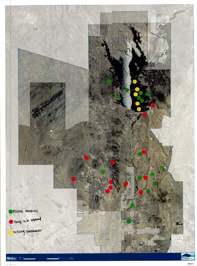
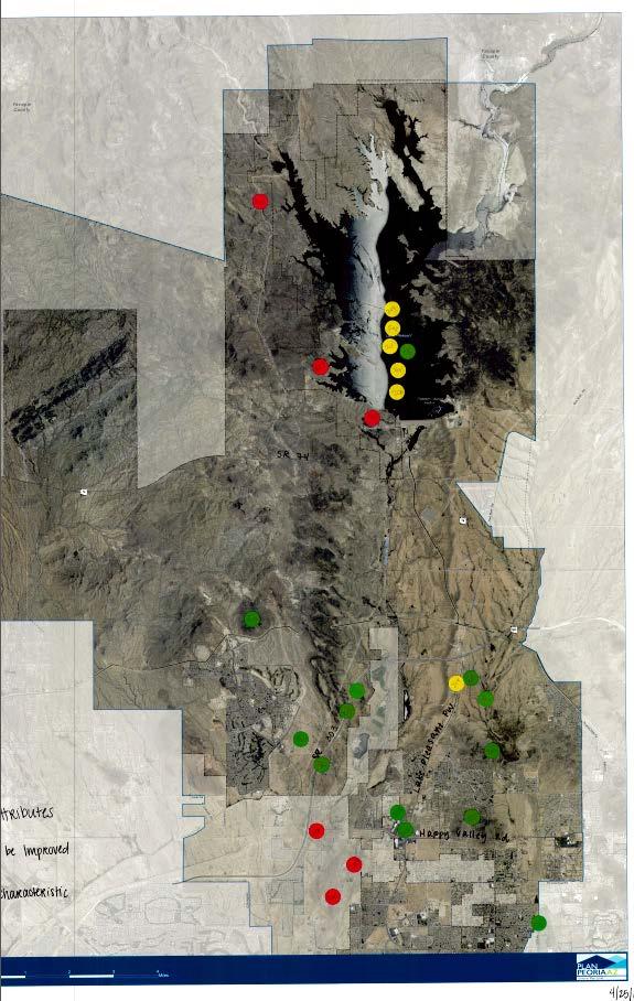
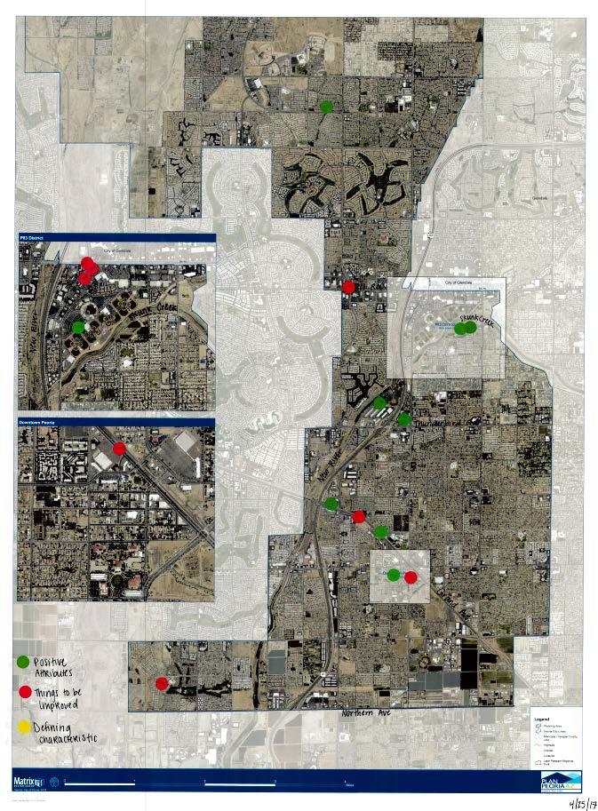
7 Plan Peoria AZ Public Workshop #1 April Day # Green, Red, or Yellow Category: (Public Safety, Transportation, Parks and Recreation, Natural Environment, Land Use, Economic Development) Mapping Exercise Results Comment Monday 4 G PS Public safety building Tuesday 107 R PS Blight along Grand Avenue Tuesday 108 R PS Crime coming up from Glendale Wednesday 708 R PS 91st - unsafe - needs to be incorporated Monday 5 G T 303 Monday 56 G T Transportation corridors Monday 3 G T 101 Monday 70 G T Lake Pleasant Parkway recent improvements from 303 south into Peoria Tuesday 213 G T good transportation. Opportunity for development Tuesday 252 G T opportunity for growth on Grand Tuesday 253 G T improve Grand Monday 9 Monday 57 Monday 60 Monday 63 Monday 160 Monday 161 Monday 162 Monday 168 Monday 169 Monday 183 Tuesday 103 Tuesday 104 Tuesday 105 Tuesday 251 Tuesday 254 Wednesday 601 R T Traffic at 83rd by stadium R T Traffic congestion on Vistancia R T Road to Canyon Raceway R T No exit out west side of Vistancia R R R T T T Don't leave older part of Peoria behind, Central area of Peoria - sidewalks are insufficient. Need traffic calming in these areas. Don't leave older part of Peoria behind, Central area of Peoria - sidewalks are insufficient. Need traffic calming in these areas. Don't leave older part of Peoria behind, Central area of Peoria - sidewalks are insufficient. Need traffic calming in these areas. R T Traffic. Hard to get around R T Traffic awful here R T Grand traffic is bad. Especially when getting into Sun City R T Bottle neck at intersection R T Bottle neck at intersection R T Bottle neck at intersection R T traffic on Grand Avenue is a barrier R T Bottle necking. Traffic bad here R T Bell and 91st - traffic is a disaster
8 Wednesday 617 Wednesday 618 Wednesday 632 Wednesday 702 Wednesday 709 Monday 15 Monday 81 Monday 156 Monday 157 Monday 158 Monday 159 Monday 165 Monday 172 Monday 173 Tuesday 202 Tuesday 203 Tuesday 209 Tuesday 210 Tuesday 215 Tuesday 216 Tuesday 255 Tuesday 256 Tuesday 257 Tuesday 258 Tuesday 259 Tuesday 507 Wednesday 606 R T traffic issues R T traffic is bad R T loop - east bound access to 101 is bad R T Happy Valley to the 303 traffic back up. Sync lights R T Jomax needs a bike lane and widening both ways G PR Community Center G PR Community Park 3 - Plan for Expansion G PR Trail system on Rio is positive - all along through Skunk Creek G PR Rio is an asset G PR Rio is an asset G PR Peoria rec center does amazing job G PR love canal system G PR Park is positive step in right direction G PR scenic area G PR hiking G PR bike trails G PR hiking and trails G PR sunrise mountain hiking G PR new community park three and amenities G PR lake pleasant recreation activities G PR Rio Vista is one of the best things in Peoria G PR Rec center in Rio Vista is great G PR Opened bike area at Skunk Creek G PR bike trails G PR access to library G PR regional park G PR New River Trail
9 Wednesday 633 Wednesday 705 Wednesday 712 Wednesday 715 Tuesday 67 Tuesday 80 Tuesday 82 Tuesday 84 Tuesday 214 Tuesday 214 Tuesday 704 Monday 52 Monday 55 Monday 58 Monday 61 Monday 69 Monday 71 Monday 72 Monday 75 Monday 707 Monday 710 Monday 711 Monday 713 Monday 1 Monday 62 Monday 65 Monday 71 G PR Trail system and park at Rio Vista G PR Maricopa Trail miles through the city G PR Trail system on Rio is positive - all along through Skunk Creek G PR great camping area R PR need hiking trails R PR protection of cultural / historical sites R PR major art and cultural center somewhere along major arts center like Mesa R PR Preserving cultural heritage and sites Y PR New Community Park Three Y PR Lake Pleasant (camping, boating, picnics) rec Y PR trail system G NE Lake Pleasant G NE Natural beauty of mountains G NE Lake Pleasant G NE West Wing Park hiking G NE Lake Pleasant G NE Lake Pleasant G NE Lake Pleasant promotes Peoria - fishing and boating G NE Lake Pleasant recreation G NE Keep natural environment G NE Keep natural environment G NE Leverage Lake Pleasant G NE Lake Pleasant
10 Monday 76 Tuesday 204 Tuesday 211 Tuesday 212 Tuesday 504 Wednesday 703 Monday 11 Monday 78 Monday 79 Monday 153 Monday 154 Tuesday 106 Tuesday 506 Wednesday 631 Wednesday 714 Monday 7 Monday 8 Monday 53 Monday 54 Monday 155 Monday 164 Tuesday 501 Wednesday 607 Wednesday 625 Wednesday 627 Wednesday 628 Wednesday 629 G LU redevelopment in downtown Peoria G LU commercial growth G LU Leverage amenities along 303 G LU Peoria schools positive G LU Schools are positive G LU Peoria Stadium or entertainment opportunities G LU Vistancia open land zoned commercial G LU Nice area in Old Town. The rest should look like this G LU 303 corridor leverage for future growth R LU Northern Parkway needs to be watched -> make sure right development R LU need redevelopment in downtown Peoria R LU overcrowding of schools R LU overcrowding of schools R LU Grand Ave - Commercial needs improvement R LU downtown needs love but is a defining characteristic of Peoria R LU Develop around Lake Pleasant R LU Develop field before developing any further north R LU State land area is clogging development and don't pay taxed. Needs to be annexed R LU No rhyme or reason to development here R LU Liberty HS overcrowded R LU 91st and Peoria - empty lots. Trailers. Unattractive
11 Wednesday 706 Monday 2 Monday 6 Monday 10 Monday 59 Monday 64 Monday 77 Monday 151 Monday 163 Monday 180 Monday 181 Tuesday 110 Tuesday 201 Tuesday 208 Tuesday 505 Tuesday 508 Wednesday 602 Wednesday 604 Wednesday 605 Wednesday 611 Wednesday 612 Wednesday 613 Wednesday 614 Wednesday 615 Wednesday 620 Wednesday 621 Wednesday 701 R LU No over housing in the area G EC Peoria Stadium G EC Arrowhead G EC Distillery G EC Canyon Raceway G EC Scorpion Bay and restaurant G EC Opportunity for a world class resort - while it's affordable G EC Fun activity for families- baseball stadium G PR Sports complex is positive. Great community G EC Rio Vista great G EC Sports complex great. Creates traction G EC Redevelopment opportunities in downtown G EC shopping G EC sufficient shopping - expand, more restaurants G EC 303 Economic Development G EC 303 Economic Development and housing G EC Peoria sports complex G EC Spring training at Sports complex G EC broadway theater G EC Opportunity for economic development. entertainment i.e. movie theater G EC Nice center. Good mix of housing and restaurants. Unique. Walkable. Well done. G EC Distillery. Lots of opportunity here G EC sports complex is great G EC Distillery. Lots of opportunity here G EC good dining G EC opportunity with P83 G EC 99th and Lake Pleasant
12 Monday 12 Monday 13 Monday 14 Monday 16 Monday 68 Monday 73 Monday 74 Monday 182 Tuesday 109 Tuesday 217 Wednesday 616 Wednesday 622 Wednesday 623 Wednesday 624 Wednesday 626 Wednesday 630 R EC Vacant R EC Vacant R EC Historical society needs redevelopment R EC can't keep businesses open R EC Need more schools up north R EC need more restaraunts, hotel, shopping R EC need more restaraunts, hotel, shopping R EC Dam river and make a river walk with boutiques, cafes, spray misters. Create traction R EC Infrastructure needs improvement in downtown R EC hotel/lodging needed at Lake Pleasant R EC more local dining - not chains R EC too many big boxes on Grand Ave. This particular one is run down R EC run down R EC needs better development R EC no big boxes here - half built R EC vacant big boxes
Rock Spring Kick-Off Meeting 09/01/15 Walter Johnson High School Break Out Table Summaries. Rock Spring Break Out Table Comments. Table 1: Strengths:
 Rock Spring Break Out Table Comments Table 1: Strengths: Trees, open areas 1 Medical Care, Offices Parking at Medical important Mall access Good access to emergency services/police/ambulance/fire Weaknesses:
Comments The Plan for Port Whitby
 Comments The Plan for Port Whitby April 24th, 2013 Community Meeting #2 Summary Report Prepared by GLPi April 29th, 2013 1 Introduction The purpose of the Port Whitby Secondary Plan Update, Community Improvement
Cherry Creek Transportation and Land Use Forum September 25, 2013 Meeting Summary
 Cherry Creek Transportation and Land Use Forum September 25, 2013 Meeting Summary I. LEAD-IN TO SMALL GROUP DISCUSSION, POLLING AND STEERING COMMITTEE/TECHNICAL TASK FORCE DISCUSSION The meeting began
Cottage Grove Road Activity Centers Plan
 Cottage Grove Road Activity Centers Plan Cottage Grove Road January 31, 2107 Kick Off Meeting Input Cottage Grove Road Corridor Visioning Exercise What would you like to see in 20 years? 10 Years? A vision
Areas for Redevelopment or New Development:
 Small Group Exercise Summary Areas for Redevelopment or New Development: 1. Downtown a. Job Resource Center b. Community Activities / Activities to draw youth & millennials c. Need for additional parking
REDEVELOPMENT OPPORTUNITY! FOR SALE
 SALE PRICE: Contact Agent LOT SIZE: 0.31 Acres BUILDING SIZE: 2,830 SF YEAR BUILT: 1906 ZONING: CBD Central Business District CROSS STREETS: 2nd Street South PROPERTY OVERVIEW This offering is for the
Irondale on the Move Public Outreach Summary to Date. July 8, 2015
 Irondale on the Move Public Outreach Summary to Date July 8, 2015 Visioning Survey Results 467 Total Responses What do you consider to be the top two strengths of the City of Irondale from your perspective?
Property Owner Survey Results
 Property Owner Survey Results 1. What are the most positive aspects of the Golden Mile? (check all that apply) Response Response Existing mix of businesses 50.0% 20 Good access to major roads 85.0% 34
Bikeway action plan. Bicycle Friendly Community Workshop March 5, 2007 Rochester, MN
 Bikeway action plan Summary The was held on March 5, 2007 at the Rochester Mayo Civic Center. The workshop was hosted by Rochester-Olmsted County Planning Department in collaboration with the League of
Perryville Transit Oriented Development & Greenway Plan
 A Partnership of the Town of Perryville and WILMAPCO Perryville Transit Oriented Development & Greenway Plan Why plan for TOD and Greenways? Identify strategies to enhance community character in Perryville
Provide Employee Parking
 Parking Objectives Provide Employee Parking 1. Provide safe, convenient paid parking for employees 2. Reduce employee use of downtown on-street parking Parking Objectives Manage Delivery Truck Access 1.
64% UNSAFE and. Where can features be added to improve the street for bicyclists?
 BICYCLING Where can features be added to improve the street for bicyclists? Due to its proximity to neighborhoods, downtown and the waterfront, many people bike Niagara Street to get to where they need
The Bike Buzz in Richland. November 2017 Carl Berkowitz
 The Bike Buzz in Richland November 2017 Carl Berkowitz Richland has been growing by leaps and bounds with lots of new homes and roads throughout the community. Recognizing all the growth in the Queensgate
Charrette #1 Keypad Polling Results. June 27, 2012
 Charrette #1 Results June 2, 2012 1. My affiliation with Opelika Road is (Choose all that apply) 1 2 Business owner Property owner 12 4 Business owner Property owner 2 1 2 2 Nearby resident Business patron
Tuesday, September 25 th Mount Holly Municipal Complex 400 East Central Avenue 5:30pm to 7:30pm. Activity Stations o Where do you Live?
 Meeting Information Overview The public workshop for the Mount Holly Comprehensive Bicycle Plan occurred on September 25, 2018. The drop-in workshop allowed attendees to participate in a series of interactive
DES MOINES AREA MPO. Presentation to Iowa Commercial Real Estate Association. April 6, 2017
 DES MOINES AREA MPO Presentation to Iowa Commercial Real Estate Association April 6, 2017 Presentation Outline MPO Overview Trends We re Watching Plans, Projects, Initiatives, Regional Transportation Priorities
COWETA HIGH SCHOOL AND EAST HIGHWAY 51
 COWETA HIGH SCHOOL AND EAST HIGHWAY 51 Lack of sidewalks along Ben Lumpkin Rd. Lack of crosswalks and ramps at intersection. Hwy 51 is wide to cross as a pedestrian. No ADA compliance or connection to
COMMUNITY CHOICES EVENTS High Schools. February 13-22, 2014
 COMMUNITY CHOICES EVENTS High Schools February 13-22, 2014 In February 2014, the City held a series of events to gain public input on the Arvada Comprehensive Plan Update. Outreach included engaging approximately
Austin Avenue Bridges Project. Public Meeting Summary
 Austin Avenue Bridges Project Public Meeting Summary June 29, 2016 Red Table Safety and Connectivity Notes: 1. Would like to see forensic report evaluations 2. What is the lifespan? 3. Extend safety considerations
East Burke Transportation, Safety and Capacity Improvements
 East Burke Transportation, Safety and Capacity Improvements The purpose of this project is to increase mobility and improve safety for pedestrians, cyclists, and motor vehicles along VT Route 114 in the
CASE STUDY WALKABLE WASHINGTON WHO WE ARE & WHAT WE DO CITY OF BOTHELL DOWNTOWN REVITALIZATION PLAN BOTHELL, WA
 LKABLE SHNGTON Transformation towards walkability is taking place all over the state of Washington. From urban, suburban and small town initiatives, the program showcases the effects of a renewed focus
Table #6 VISION CHARACTERISTICS
 Table #6 VISION White Flint is a place to live, work, play, shop, and walk with sufficient density to encourage quality redevelopment. Vibrant streets and consistent streetscapes are important. CHARACTERISTICS
Appendix. 108 Gehl Studio
 6 Appendix 18 19 How People Walk: Overview How People Bike: Overview Pockets of great walkability... Broadway & 11th Weekday Few people biking Broadway & 11th, Weekday 1 9 8 7 6 275 Peds/ average per hour
APPENDIX 1 QUESTIONNAIRE RESULTS
 APPENDIX 1 QUESTIONNAIRE RESULTS NORTHERN BERKS REGION PLANNING QUESTIONNAIRE 1. From 1990 to 2000, the population of the Northern Berks Region grew from 11,810 to 13,372, a 13.2% increase. In the future,
Perryville TOD and Greenway Plan
 Perryville TOD and Greenway Plan Greenway Glossary Pathway: A bicycle and pedestrian path separated from motorized vehicular traffic by an open space, barrier or curb. Multi-use paths may be within the
DATE: June 22, General Release SUBMITTED BY: LAND DEVELOPMENT SERVICES. RE: City Centre Survey Results
 DATE: June 22, 2018 TO: General Release SUBMITTED BY: LAND DEVELOPMENT SERVICES RE: City Centre Survey Results The following is a summary of preliminary findings for the Community Identity and Vision survey.
ALPHARETTA, GA FOR LEASE
 PROPERTY HIGHLIGHTS Approximately 18,283 SF two-story office building Up to 9,427 SF available for lease 6,377 RSF total contiguous space available (suite 200/210) Offered for lease at $15.50/SF full service
o n - m o t o r i z e d transportation is an overlooked element that can greatly enhance the overall quality of life for the community s residents.
 N o n - m o t o r i z e d transportation is an overlooked element that can greatly enhance the overall quality of life for the community s residents. 84 Transportation CHAPTER 11 INTRODUCTION Transportation
Centennial Neighbourhoods Transportation Management Plan Summary of Phase 1 Consultation. Overview of Issues
 1 Centennial Neighbourhoods Transportation Management Plan Summary of Phase 1 Consultation The Centennial Neighbourhoods Transportation Management Plan (CNTMP) is being undertaken to support the Secondary
50 Avenue S.W. Corridor Study Glenmore Aquatic Centre Drop-In Event
 Project overview The City of Calgary is conducting a transportation corridor study of 5 Avenue S.W., between Crowchild Trail and 4A Street S.W. In 29, it was reclassified as a Parkway under the Calgary
HELM RANCH ROUND 2 - COMMUNITY WORKSHOP AND OPEN HOUSE SUMMARY
 HELM RANCH ROUND 2 - COMMUNITY WORKSHOP AND OPEN HOUSE SUMMARY Tarpey Elementary School, Clovis, CA October 15, 2014 6:30pm-8:30pm OVERVIEW On Wednesday, October 15, 2014, staff from the City of Clovis
CMAQ DETAILED PROJECT LISTING REPORT ( FY 2002 )
") Fiscal Year = 'By Fiscal Year' and Status Selection Criteria = 'All' and State = '' 7/16/2003 $40,173,660 $40,575,179 101 $1,245,000 Demand Management Trip Reduction Prog Travel Reduction Pro Telwork Outreach
Fiscal Year = 'By Fiscal Year' and Status Selection Criteria = 'All' and State = '' 7/16/2003 $40,173,660 $40,575,179 101 $1,245,000 Demand Management Trip Reduction Prog Travel Reduction Pro Telwork Outreach
What do you like about the Woodland District? What brings you here? (places, activities, etc.)
") What do you like about the Woodland District? What brings you here? (places, activities, etc.) Group Dave Response/Notes Services/shopping/banking/med Transit ical Nice streets tree lined Access to I 5
What do you like about the Woodland District? What brings you here? (places, activities, etc.) Group Dave Response/Notes Services/shopping/banking/med Transit ical Nice streets tree lined Access to I 5
Appendix C: Online Survey Comments
 Appendix C: Online Survey Comments Ideas Eagle Transit TDP Update Online Survey Comments It would be nice to be able to ride the bus to and from work to save gas and wear and tear. I would just like to
Coachella Fiesta de la Salud #3 Summary
 Coachella Fiesta de la Salud #3 Summary Community Health and Wellness General Plan Element Public Workshop T h u r s d a y, September 20, 2012 Project Overview The City of Coachella is updating their General
Safe Streets. City of Lake Forest Park. March 21, 2017
 Safe Streets City of Lake Forest Park March 21, 2017 1 01 WELCOME 2 Agenda WELCOME WHAT IS THIS PROJECT? CONTEXT DRAFT CITYWIDE PROJECTS EXERCISE INTRODUCTION 3 02 WHAT IS THIS PROJECT? 4 WHAT IS THIS
CONNECTING PEOPLE TO PLACES
 CONNECTING PEOPLE TO PLACES 82 EAST BENCH MASTER PLAN 07 Introduction The East Bench transportation system is a collection of slow moving, treelined residential streets and major arteries that are the
FEDERAL FISCAL YEAR 2020 TAP PUBLIC COMMENTS
 FEDERAL FISCAL YEAR 2020 TAP PUBLIC COMMENTS Ankeny High Trestle Trail Extension Yes 14 No 1 High Trestle Trail is our St. Louis Arch. Close that gap. Yes, extend it! The High Trestle Trail is already
General Plan Community Meeting Summary Ward 3 Santiago Elementary School 2212 North Baker Street Thursday, March 31, :00 p.m. to 8:00 p.m.
 PARTICIPANTS General Plan Community Meeting Summary Ward 3 Santiago Elementary School 2212 North Baker Street Thursday, March 31, 2016 6:00 p.m. to 8:00 p.m. A General Plan community meeting was held on
MOUNT CLEMENS, MICHIGAN
 Prepared For: Mount Clemens Downtown Development Authority Downtown District Plan MOUNT CLEMENS, MICHIGAN Prepared By: Michigan State University Practicum Josh Croff Emily Gehle Justin Habalewsky Daniel
Comprehensive Bicycle Master Plan 2014 ITE-IMSA Spring Conference March 6, 2014
 Comprehensive Bicycle Master Plan 2014 ITE-IMSA Spring Conference March 6, 2014 Street Transportation Department Inventory of Bikeways (October 7, 2013) 22 bike bridges 20 bike tunnels 420 miles of bike
WELCOME. Thank you for joining us at the Second Public Workshop for the Carlsbad Pedestrian Master Plan. We look forward to receiving your feedback.
 City of Carlsbad Pedestrian Master Plan: WELCOME WELCOME Please Sign In Provide Input at Flip Charts Review Boards Presentation of Draft Plan Thank you for joining us at the Second Public Workshop for
PARADISE VALLEY TRAIL GUIDE
 PARADISE VALLEY TRAIL GUIDE 4949 East Lincoln Drive Paradise Valley, AZ 85253 (480) 627-3200 omnihotels.com/montelucia omnihotels.com/montelucia HIKE, RUN & RIDE IN PARADISE VALLEY The beautiful weather
SPON GENERAL PLAN UPDATE COMMITTEE MEETING Saturday, February 24, 2018
 Saturday, February 24, 2018 Santa Ana Heights Fire Station Community Room 20401 SW Acacia St, NB 92660 (Acacia at Mesa) AGENDA 2:00 Welcome and Introductions (Dennis Baker) 2:10 Updates (Dorothy Kraus)
Bicycle Lanes Planning, Design, Funding South Mountain Partnership Trails Workshop Roy Gothie PennDOT Statewide Bicycle Pedestrian Coordinator
 Bicycle Lanes Planning, Design, Funding 2018 South Mountain Partnership Trails Workshop Roy Gothie PennDOT Statewide Bicycle Pedestrian Coordinator Policy Changes: BOP Bicycle Policy Changes The OLD Way
Tonight is for you. Learn everything you can. Share all your ideas.
 Strathcona Neighbourhood Renewal Draft Concept Design Tonight is for you. Learn everything you can. Share all your ideas. What is Neighbourhood Renewal? Creating a design with you for your neighbourhood.
Transportation & Land Use. Workshop: March 6, 2013
 Marpole Community Plan Transportation & Land Use Workshop: March 6, 2013 Overview 1 Community Plan 2 Transportation 2040 & Community Plans 3 4 Overview 1 Community Plan 2 Transportation 2040 & Community
April 28, 2011 NYU Wagner Capstone: Rye YMCA
 April 28, 2011 NYU Wagner Capstone: Rye YMCA Slide 1 CAPSTONE OVERVIEW April 28, 2011 NYU Wagner Capstone: Rye YMCA Slide 2 WHY COMPLETE STREETS April 28, 2011 NYU Wagner Capstone: Rye YMCA Slide 3 April
Public Feedback Comments Appendix G. Appendix G. Public Feedback Comments. Virginia Beach Bikeways and Trails Plan 2011 Page G-1
 Public Feedback Comments Virginia Beach Bikeways and Trails Plan 2011 Page G-1 This is a complete collection to date of responses to the feedback survey which was used at public open houses in December
Transportation Assessment
 Transportation Assessment Midtown Open House February 10, 2018 Overview Midtown in Focus Overview & Purpose of Today Transportation Assessment overview Summary of Transportation work to date Review & Analysis
Summaries from the Concentric Circle Exercises 10 Neighborhood Forums held in April and May 2018 Various locations around Town
 Summaries from the Concentric Circle Exercises 10 Neighborhood Forums held in April and May 2018 Various locations around Town A Concentric Circle exercise was conducted at all 10 neighborhood meetings.
Cottonwood Heights HAWK Pedestrian Crossing on Fort Union Blvd. Project Type Capital Improvement
 Cottonwood Heights HAWK Pedestrian Crossing on Fort Union Blvd. At West Side of Mountview Park Entrance (Approx. 1600 East) $ 206,800 $ 192,800 Install a HAWK Pedestrian Crossing System on Fort Union Boulevard,
2016 I-30 CROSSING ARKANSAS BOULEVARD KEY IDEAS OF PLAN B:
 KEY IDEAS OF PLAN B: Transportation shall support all parts of the cities and improve the quality of life downtown. There is no need to shorten commuting time at rush hour by a few minutes at the risk
Building a Liveable Ottawa 2031 Backgrounder 5: Barrhaven/Riverside South/Leitrim
 Building a Liveable Ottawa 2031 Backgrounder 5: Barrhaven/Riverside South/Leitrim Wards 3 and 22 Official Plan Transportation Master Plan Cycling Plan Pedestrian Plan October 2013 ottawa.ca/liveableottawa
Sistrunk Corridor DOTMOCRACY SUMMARY
 DOTMOCRACY SUMMARY The TOUCH initiative is a true collaborative working with multi- sector community organizations and agencies to reduce tobacco use and exposure to secondhand smoke, improve access to
AIA Sectional Cross Country Championships Thursday, November 1, 2018
 AIA Sectional Cross Country Championships Thursday, November 1, 2018 Location: Rose Mofford Sports Complex 9833 N 25 th Ave Phoenix, AZ 85021 From the I-17 : Take the Dunlap Exit (#207). Turn east onto
Public Meeting #1 January 30, 2018
 Public Meeting #1 January 30, 2018 Meeting Outline Mayor s Introduction Presentation Q&A Group Activities Wrap-up Presentation Outline Introduction Existing Conditions Market Assessment Break-out Setup
Merrick and Memorial Neighborhood Study 5/14/2014 Public Meeting
 Merrick and Memorial Neighborhood Study 5/14/2014 Public Meeting Study Area April 9 Public Meeting Comments Summary Pedestrian Safety - A Walking Neighborhood Pedestrian traffic is very difficult A need
Roads and Vehicular Traffic Design Principles. Roads and Vehicular Traffic Recommendations
 CIRCULATION AND PARKING roads and vehicular traffic The Campus Master Plan updates the campus transportation network through a multi-modal approach that encourages walking and biking while improving vehicular
APPENDIX A. Outreach Summary
 APPENDIX A Outreach Summary COUNTYWIDE TRANSPORTATION PLAN Summary of Public Outreach and Engagement To gather an understanding of the transportation issues and priorities throughout the county, and inform
PART III Neighborhood Priority Lists INTRODUCTION
 City of South Lake Tahoe General Plan Policy Document PART III s INTRODUCTION South Lake Tahoe is made up of a series of unique and distinct neighborhoods. The General Plan public outreach program focused
ROUTE 81 CORRIDOR STUDY DESIGN CONCEPTS
 RT 81 Corridor Study CLINTON ROUTE 81 CORRIDOR STUDY DESIGN CONCEPTS View north on High Street, with potential improvements to the streetscape Draft Recommendations November 8 th, 2018 TOWN OF CLINTON
Clarkson Walkability Audit: Results and Recommendations Summary
 Clarkson Walkability Audit: Results and Recommendations Summary The following document was prepared by the Region of Peel and includes a summary of comments made by participants during our breakout discussion
BORDER ECONOMIC FORUM
 TRIPLE-A BASEBALL BORDER ECONOMIC FORUM BACKGROUND How did Triple-A Baseball get here? 2010 2011 2012 2013 1 BACKGROUND How did Triple-A Baseball get here? Portland Beavers rumored for sale, Foster/Hunt
SUMMARY OF TRANSPORTATION INVESTMENTS
 Santa Cruz County 2016 Measure D: Transportation Improvement Expenditure Plan - Approved by over 2/3 of Santa Cruz County voters on November 8, 2016 - Overview Measure D, the 2016 Transportation Improvement
Presentation Comments and Questions
 Presentation Comments and Questions The community had a number of questions regarding the master plan process and operational issues in and around the MARC rail station areas. The bullet points below are
Q1 Are you a Palisades resident?
 Q1 Are you a Palisades resident? 95.24% 0.68% If no, on what street do yo... 4.08% If no, on what street do you live? (please supply your street name and municipality) 95.24% 140 0.68% 1 4.08% 6 # If no,
COASTAL RAIL TRAIL ROSE CREEK BIKEWAY PROJECT COMMUNITY WORKSHOP #2 AUGUST 15, 2013
 COASTAL RAIL TRAIL ROSE CREEK BIKEWAY PROJECT COMMUNITY WORKSHOP #2 AUGUST 15, 2013 CHRIS CARTERETTE, AICP PROJECT MANAGER Chris.Carterette@sandag.org Direct: 619-699.7319 REGIONAL PLANNING BACKGROUND
Berkeley SOSIP. My Focus
 Page 1 of 8 Berkeley SOSIP Produced by the Preservation Institute My Focus Overview My Focus The Key Change Berkeley Way/Shattuck Berkeley Way Sidewalk In my opinion, the most exciting thing about the
MEETINGS & CONFERENCES
 MEETINGS & CONFERENCES EXPERIENCE THE SOUL OF THE MOUNTAINS. BE WELCOMED BY A LEGENDARY VALLEY. FIND NEW INSPIRATION AMIDST CENTURY-OLD TREES AND STUNNING GRANITE MOUNTAIN PEAKS. THE SQUAW VALLEY ALPINE
Ride Share Month Events Successful! Valley Metro and Governor Jan Brewer declared
 T h e b l u e S k y V i e w A p u b l i c a t i o n o f v a l l e y m e t r o b u s i n e s s s e r v i c e s Spring 2010 Ride Share Month Events Successful! Valley Metro and Governor Jan Brewer declared
UNIVERSITY AVENUE CORRIDOR REDESIGN. January 8, 2017 PUBLIC OPEN HOUSE
 January 8, 2017 PUBLIC OPEN HOUSE COLLABORATIVE COMMUNITY-BASED DESIGN IS THE FOUNDATION TO A SUCCESSFUL PROJECT AGENDA FOR TONIGHT 1 INTRODUCTIONS 2 WHY ARE WE HERE PROJECT NEED 3 SCHEDULE & GOALS 4 OPEN
TRANSPORTATION COMMISSION Agenda Staff Report
 TRANSPORTATION COMMISSION Agenda Staff Report Agenda Item No. 5.a DATE: JULY 31, 2014 TO: FROM: SUBJECT: TRANSPORTATION COMMISSION COMMUNITY DEVELOPMENT DEPARTMENT - PLANNING DRAFT OLYMPIC CORRIDOR PREFERRED
Vision: Traditional hamlet with an attractive business/pedestrian friendly main street connected to adjacent walkable neighborhoods
 N D. Focus Area II Vision: Traditional hamlet with an attractive business/pedestrian friendly main street connected to adjacent walkable neighborhoods Transit Road Focus Area II is located in the Hamlet
Use this guide to learn more about walkability and how you can make your community safer to walk
 Walkability Guide Do You Enjoy Walking In Your Community? Use this guide to learn more about walkability and how you can make your community safer to walk 2 About This Guide Circulate San Diego believes
Project Narrative. Albuquerque, NM. July 31, 2015
 Project Narrative Albuquerque, NM July 31, 2015 1 Project Identification As the first bus rapid transit (BRT) project in New Mexico, the Albuquerque Rapid Transit (ART) line will run through the heart
Northside Livable Centers Study
 Northside Livable Centers Study Advisory Committee Meeting #2 Preferred Conceptual Plan March 2, 2010 AGENDA FOR ADVISORY COMMUNITY WORKSHOP #1 Project Overview and Timeline Planning Area Overview Workshop
SAFE ROUTES TO SCHOOL
 SAFE ROUTES TO SCHOOL Edgewood Elementary School Existing Conditions and ACTION PLAN > Oak Creek - Franklin Joint School District Table of Contents CONTEXT Enrollment Boundaries Enrollment
San Bernardino County Non-Motorized Transportation Plan - Chapter 5
 City of Yucaipa Population 51,476 City Overview Yucaipa is located in the eastern portion of the San Bernardino Valley area, at the foot of the San Bernardino Mountains, between the Cities of Redlands
What are the Qualities that make Newark a Bicycle Friendly Community? What are aspects that make Newark less Bicycle Friendly?
 What are the Qualities that make Newark a Bicycle Friendly Community? Many stores are within biking distance (1) Lots of bike lanes and new trail Existing bike routes (2) Designated bike lanes on Del ave.
City of Charlottesville Bicycle and Pedestrian Master Plan Update
 City of Charlottesville Bicycle and Pedestrian Master Plan Update September 17, 2014 I. Welcome and meeting overview II. Project status update III. Network overview IV. Break-out groups Pedestrian Network
162 RESIDENTS ATTENDED 2 DAYS OF WORKSHOPS 15 TABLE DISCUSSIONS WHAT WE HEARD. Oakridge Municipal Town Centre Workshops PLANNING PROGRAM
 OAKRIDGE MTC WORKSHOP 2017 CAMBIE CORRIDOR Phase 3 STEP 3: 3: October June 2017 CAMBIE CORRIDOR PLANNING PROGRAM 2 DAYS OF WORKSHOPS 15 TABLE DISCUSSIONS 162 RESIDENTS ATTENDED WHAT WE HEARD Oakridge Municipal
Corpus Christi Metropolitan Transportation Plan Fiscal Year Introduction:
 Introduction: The Safe, Accountable, Flexible, Efficient Transportation Equity Act: A Legacy for Users (SAFETEA-LU) has continued the efforts started through the Intermodal Surface Transportation Efficiency
What are the greatest challenges for the Route 9 Corridor? Number of responses received by category
 12 All Responses Unemployment Construction Lack of activities Lack of businesses Sanitation/Maintenance Joblessness Accidents on Route and Memorial Drive Joblessness Homeless Construction Making friends
Ski Canada Ski Test 2013 Itinerary
 Sunday, March 3 rd Ski Canada Ski Test 2013 Itinerary 6:30pm 7:30pm Welcome Meeting for Manufacturer s & Reps @ Griz Bar Welcome packages, lift passes, explanation of weeks events Welcome Meeting for Testers
Encouragement. Chapter 4. Education Encouragement Enforcement Engineering & Facilities Evaluation & Planning. Encouragement Chapter 4
 Encouragement Education Encouragement Enforcement Engineering & Facilities Evaluation & Planning Photo above: Children show off their ribbons at the Tour de Virginia Beach. Virginia Beach Bikeways and
Chapter 5. Complete Streets and Walkable Communities.
 Chapter 5. Complete Streets and Walkable Communities. 5.1 Description of Complete Streets. Cities throughout the world, and specifically the United States, are coming to embrace a new transportation and
Executive Summary Route 30 Corridor Master Plan
 Route Corridor Master Plan Project Overview The Route Corridor Master Plan is a coordinated multimodal transportation and land use plan for the entire stretch of Route through East Whiteland Township,
Route 7 Corridor Study
 Route 7 Corridor Study Executive Summary Study Area The following report analyzes a segment of the Virginia State Route 7 corridor. The corridor study area, spanning over 5 miles in length, is a multi
CAMPUS MASTER PLAN UPDATE
 FLORIDA INTERNATIONAL UNIVERSITY CAMPUS MASTER PLAN UPDATE 2010-2020 Work Session #2 FOCUS GROUP 6 2 Group 6 Transportation Typical items to be discussed at each Focus Group Provide overview of Campus
City of Jonestown Transportation Capital Improvement Plan
 City of Jonestown Transportation Capital Improvement Plan 2016-2021 T h e p u r p o s e o f t h i s d o c u m e n t i s t o i d e n t i f y a n d p r i o r i t i z e t r a n s p o r t a t i o n i m p r
CITY OF BLOOMINGTON COMPLETE STREETS POLICY
 CITY OF BLOOMINGTON COMPLETE STREETS POLICY POLICY OBJECTIVE: The City of Bloomington will enhance safety, mobility, accessibility and convenience for transportation network users of all ages and abilities,
Front and Myrtle Improvement Project
 Front and Myrtle Improvement Project MAKING BOISE THE MOST LIVABLE CITY IN THE COUNTRY DOWNTOWN: Our unique and vibrant urban neighborhood GUIDING PRINCIPLES: Innovation Celebration Transportation Downtown
Sustainable Mobility in Greater Sudbury NeORA Conference September 25, 2012
 Sustainable Mobility in Greater Sudbury NeORA Conference September 25, 2012 Presented by: David Shelsted, MBA, P.Eng., Director of Roads & Transportation Services The City s Transportation Network Approximately
EXECUTIVE SUMMARY. Vision
 Vision Walking and bicycling in Salt Lake City will be safe, convenient, comfortable, and viable transportation options that connect people to places, foster recreational and economic development opportunities,
Bicycle Pedestrian Master Plan Pre Bid Meeting Portsmouth, NH August 15, 2013
 Bicycle Pedestrian Master Plan Pre Bid Meeting Portsmouth, NH August 15, 2013 2005 Master Plan GOAL: Provide for safe and convenient bicycle and pedestrian circulation throughout the City. Develop a city
City of San Bernardino
 City of San Bernardino Population 204,800 City Overview The City of San Bernardino is the largest City and the county seat of San Bernardino County, California. The City encompasses approximately 81 square
Trails that Transform: The Economic Impact of Bicycle Tourism
 Trails that Transform: The Economic Impact of Bicycle Tourism September 2016 Economic Growth Summit Alta Planning + Design Nation s leading team of bicycle, pedestrian, greenways, and trails planning and
Overview: Phase 3 Draft Development and Circulation Plans, White Bear Station
 Overview: Phase 3 Draft Development and Circulation Plans, White Bear Station This overview explains how to get more involved and provides information on the Phase 3 draft circulation and development plans
Hennepin County Bicycle and Pedestrian Planning
 Hennepin County Bicycle and Pedestrian Planning 1 Value of bicycle and sidewalk systems Safety Livability Mobility Health Personal Finances Economic Sustainability Clean Air Recreation Parking and congestion